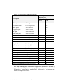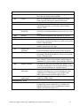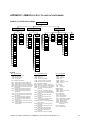
1
ABMI Remote Sensing Group August 2011 ABMI PHOTO-PLOT INTERPRETATION MANUAL Alberta Biodiversity Monitoring Institute Remote Sensing Group Version 2.4.1 August 2011 Castilla, Hird, Maynes, McDermid – ABMI Photo-Plot Interpretation Manual, v2.4.1 ABMI Remote Sensing Group August 2011 About this document Title Purpose Filename Authors Document history Current version. Changes to previous version. Date Status Target readership General readership Correct reference Copyright notice ABMI Photo-Plot Interpretation Manual To provide guidance, in particular specifications and standards, to interpreters working in ABMI photo-plots. ABMI_photoplot_InterpManual_v240_sent20110431.pdf Guillermo Castilla, Jennifer Hird, Bryce Maynes, and Greg McDermid V20081103 First version, based largely on AVI. V20081217 2nd version incorporating recommendations from the ad hoc working group (ABMI, ASRD and Timberline), and further streamlined and put into the format of AVI Chapter 4 (depletions). V20090107 incorporating feedback from Jim Schieck (ABMI) V20090119 (version 2.1.1) incorporating further feedback. This version was the one used for the 1st pilot. V20090401(version 2.1.2) incorporating feedback from ABMI Workshop participants (ABMI, ASRD, Timberline, GreenLink), and used for 2nd pilot. V20090924, incorporating feedback and evaluation of the 2nd pilot. V20091021, incorporating feedback from ABMI. This was the version used for the 3rd pilot. V20100426 (V2.3.0), final adjustments made based on 3rd 8plot pilot. V20100616 (V2.3.1), minor editorial changes, some additional adjustments to criteria/standards. This was the version used for the 54 plot contract of FY 2010-11. V20110429 (V2.4.0), Change of minimum width (now at 20 m) and size constraints (removal of the 5 ha constraint); addition of a unified wetland classification system; additional emphasis on use of compound infrastructure types; and revised standards for anthropogenic corridors. V20110831, (2.4.1) Minor editorial changes 2011/08/31 Final Draft, used for operational-level photo-plot mapping within the ABMI Persons involved in ABMI photo-plot-mapping Public Castilla G, Hird J, Maynes B, McDermid GJ (2011) ABMI Photo-Plot Interpretation Manual, Version 2.4.1 A few paragraphs of this document are partial verbatim reproductions of ASRD’s AVI interpretation standards 2.1.1. Appendix on Data entry tools provided by his author Doug Crane (ASRD) Castilla, Hird, Maynes, McDermid – ABMI Photo-Plot Interpretation Manual, v2.4.1 ABMI Remote Sensing Group August 2011 TABLE OF CONTENTS 1 Introduction ...................................................................................................................... 5 1.1 Objectives ................................................................................................................... 5 1.2 Background................................................................................................................. 5 1.2.1 Image Data ...................................................................................................... 6 1.2.2 Ancillary Data ................................................................................................... 7 1.2.3 Alberta’s Vegetation Inventories: A Starting Point ........................................... 8 1.2.4 Separation between Landcover, Landuse and Infrastructure .......................... 8 1.2.5 Simultaneous use of Polygon, Line and Multi-point Features .......................... 9 1.2.6 Periodic Updating ............................................................................................ 9 2 Photo Interpretation Procedures ................................................................................. 10 2.1 Steps Prior to Photo Interpretation ........................................................................... 10 2.1.1 Preparation .................................................................................................... 10 2.1.2 Interpreter Field Plots .................................................................................... 11 2.1.3 Air Calls ......................................................................................................... 12 2.1.4 Other Plot Data .............................................................................................. 12 2.2 Age Interpretation Procedure.................................................................................... 12 2.3 General Interpretation Procedure ............................................................................. 12 2.3.1 General Directions ......................................................................................... 12 2.3.2 Digitization Guidelines ................................................................................... 13 2.3.3 Delineation Sequence .................................................................................... 15 2.3.4 Feature Attribution ......................................................................................... 16 3 Standards ....................................................................................................................... 18 3.1 General aspects........................................................................................................ 18 3.1.1 Feature Representation ................................................................................. 18 3.1.2 Minimum Mapping Units (MMU) .................................................................... 19 3.1.3 Spatial Accuracy ............................................................................................ 19 3.1.4 Data Format and Submission ........................................................................ 20 3.1.5 Metadata ........................................................................................................ 20 3.1.6 Linkage to NFI ............................................................................................... 20 3.2 Standards Audited for Quality Assurance ................................................................. 20 3.2.1 Topology ........................................................................................................ 20 3.2.2 Size Constraints ............................................................................................. 21 3.2.3 Spatial Constraints ......................................................................................... 21 3.2.4 Adjacency constraints .................................................................................... 22 3.2.5 Feature Representation ................................................................................. 22 3.2.6 Attribute Completeness, Consistency and Accuracy ..................................... 22 4 Specifications and Guidelines ..................................................................................... 23 4.1 Air Photo Acquisition................................................................................................. 23 4.2 Interpretation............................................................................................................. 23 Castilla, Hird, Maynes, McDermid – ABMI Photo-Plot Interpretation Manual, v2.4.1 ABMI Remote Sensing Group August 2011 4.2.1 Treed Features .............................................................................................. 23 4.2.1.1 Shelterbelts .................................................................................................... 27 4.2.2 Non-Treed Vegetation ................................................................................... 27 4.2.3 Non-Vegetated Cover .................................................................................... 28 4.2.4 Wetlands ........................................................................................................ 31 4.2.5 Infrastructures ................................................................................................ 37 4.2.5.1 General specifications for infrastructures ...................................................... 42 4.2.5.2 Compound infrastructures ............................................................................. 44 4.2.5.3 Linear infrastructures .................................................................................. 45 4.2.6.3 Cities and Towns ........................................................................................ 45 4.2.7 Linear Features .............................................................................................. 46 4.2.7.1 Use of Line Representation ........................................................................... 47 4.2.7.2 Anthropogenic Corridors ................................................................................ 48 4.2.7.3 Watercourses ................................................................................................. 50 4.2.8 Use of Multi-Point Representation ................................................................. 51 4.2.9 Guidelines on Specific Attributes ................................................................... 53 4.2.9.1 Moisture Regime ............................................................................................ 53 4.2.9.2 Management Status ....................................................................................... 55 4.2.9.3 Observations .................................................................................................. 56 4.2.9.4 White Area upland type (WAUL_TY) ............................................................. 56 4.2.9.5 Modifiers ........................................................................................................ 57 4.2.9.6 Hydrodynamic and Nutrient Regimes ............................................................ 59 4.2.9.7 Landcover ...................................................................................................... 59 4.2.9.8 Landuse ......................................................................................................... 59 4.2.10 Metadata Completion ................................................................................... 60 5 Quality Control ............................................................................................................... 61 6 References ..................................................................................................................... 63 APPENDIX 1: ABMI Photo-Plot Classification Schemes .............................................. 64 APPENDIX 2: ABMI Data Entry Utilities .......................................................................... 67 APPENDIX 3: ABMI Quality Control Tools ..................................................................... 71 Index .................................................................................................................................. 81 Castilla, Hird, Maynes, McDermid – ABMI Photo-Plot Interpretation Manual, v2.4.1 1 INTRODUCTION Inventories provide the basis for biodiversity monitoring by offering a baseline on which future comparisons, as well as change and trend analyses are done. ABMI requires a mapping protocol for preparing inventories with information on habitat and human use characteristics for each of the 1,656 3 by 7 km rectangles (called photo-plots) within which ABMI terrestrial field plots are located. A mapping protocol is the set of standards (the required levels of detail and accuracy for features1), specifications (the processes, methods or rules for achieving the standards) and guidelines (explanations or suggestions on how to interpret or implement the above) that dictate how the mapping activity should be performed. The ultimate goal of the protocol is to ensure that the needs of the users are met and that the data are collected and stored in a consistent manner, greatly facilitating data use and exchanges among the users. This manual describes in detail the ABMI Photo-Plot Protocol (ABMI3P). 1.1 Objectives The goal of the ABMI3P is to define the production process of the ABMI photo-plot inventory, including standards, specifications and guidelines. Specific objectives are: • Identify, define and capture the external boundaries of the different types of natural and anthropogenic features that occur within the 3 by 7 km photo-plots; or, when size or width of the features is small, identify their location using a more abstracted representation (points or lines). • Characterize each identified feature by a set of attributes. • Maintain metadata records about the capture process for each photo-plot. 1.2 Background The ABMI3P follows a baseline-monitoring approach wherein initial maps are created using softcopy interpretation of recent air-photos, reusing existing information where possible (in particular, the Alberta Vegetation Inventory – AVI – and the Grassland Vegetation Inventory – GVI). These maps are then used as a baseline for future monitoring of the spatial distribution of habitat types and anthropogenic features within each photo-plot. In 2008, ABMI entered in an agreement with a group of researchers from the University of Calgary (hereafter the Remote Sensing Group, or RSG) to develop ABMI’s remote sensing component, manage its implementation, and identify, design and conduct research to efficiently monitor habitat and human footprint (i.e., the amount of land base transformed by humans to serve their needs) across the Province. The RSG initially proposed a series of modifications to AVI standards (Alberta Sustainable Resource Development, 2005), based on similar monitoring programs implemented 1 The term feature is used throughout this document to refer to both entities on the ground and their digital representation. Castilla, Hird, Maynes, McDermid – ABMI Photo-Plot Interpretation Manual, v2.4.1 5 in other regions. Subsequently, a working group composed of key personnel from Alberta Sustainable Resource Development (ASRD) and forest resource inventory companies was established to review the proposed modifications. The recommendations of this working group were addressed, and the protocol tested in a pilot study comprising two photo-plots and carried out by certified interpreters from two companies (Greenlink Forestry Incorporated and TECO Natural Resource Group Ltd.) in winter 2009. After the successful completion of the winter 2009 pilot, the results were evaluated and a new batch of recommendations was prepared. The latter resulted in a subsequent version of the protocol (2.1.2), which was tested in a 16-plot pilot in spring 2009 that involved the same two companies. As a result of this second pilot, a new version (2.2) of the ABMI3P incorporating recommendations and feedback from the contractors and intended to address issues that arose during the spring 2009 pilot. This new version also included, for the first time, a formal Quality Control (QC) process as well as a new, preliminary set of GIS-based QC Tools. Version 2.2 of the ABMI3P was then tested in a third, 8-plot pilot undertaken over the late fall and winter of 2009-2010, this time focused on grassland and mountain areas. Based on the results of this pilot and further recommendations from the contractors who worked on it, an operationally-ready version of the ABMI3P was produced (version 2.3.1). This version was employed in a 54-plot contract that spanned fall 2010 to spring 2011. The current protocol (version 2.4.1) again reflects additional refinements that resulted from the previous 54-plot contract, focused mainly on addressing remaining ambiguities in the mapping of anthropogenic features and increasing efficiency. In particular: 1) the minimum mapping width for linear features was increased from 10 m to 20 m (the original standard the AVI; the reason for this change is that 10 m increased considerably the amount of linework, and in some cases, created problems to correctly represented some ground features such as cutblocks that often got fragmented into pieces smaller than the minimum size for upland polygons); 2) the 5 ha minimum mapping size constraints were removed (to enable easier polygon delineation, particularly in forested areas); 3) a greater emphasis is placed on the use of compound infrastructure types as opposed to the separate delineation of individual infrastructures; and, 4) a unified wetland coding/classification system is introduced, replacing the separate Green Area and White Area systems. The new system is based on the Alberta Wetland Inventory classification, with additional codes and modifiers for capturing White Area seasonalities and alkalinity 1.2.1 Image Data ABMI photo-plot inventory is done through softcopy interpretation of aerial photography, wherein a human analyst visualizes the air-photos in a stereo-viewing monitor, digitizes features on the screen, and estimates the values of the relevant attributes for each delineated feature. Management-level inventories in Alberta are normally done using medium-scale aerial film (1:15 000 or 1:20 000). However, in the case of ABMI photo-plots, the scale chosen as a reference was 1:30 000, since softcopy photogrammetry enables the use of smaller aerial photo scales, reducing the cost per km2 of the imagery. In particular, this scale enables capture of the entire photo-plot using a single flight line and only 5 overlapping frames. Sun angle concerns and leaf phenology limit the period when aerial photography can be taken to the months of May through September. The ABMI’s 1,656 sites are stratified into five panels for data acquisition purposes, each consisting of 36 clusters of 9 sites each; the plan is to acquire one panel per year. Panel A Castilla, Hird, Maynes, McDermid – ABMI Photo-Plot Interpretation Manual, v2.4.1 6 photography was captured by Land Data Technologies Inc. during summer 2008 using a conventional photogrammetric colour film (Agfa X100). The camera used was the Zeiss/Jena LMK, with lens number 7385826/C (focal length 152.141 mm). Digital imagery from an airborne multispectral sensor (Infrared + RGB) will be used to capture other panel photography (e.g. Panel B was acquired with a Vexcel Ultracam Lp at 40 cm spatial resolution). 1.2.2 Ancillary Data The interpreter is entitled to use any reliable pre-existing information that he/she might have access to from previous spatially-coincident works. Ancillary data (described only briefly in this document) that may be provided by ABMI through Alberta Sustainable Resource Development (ASRD) may include but are not limited to, clipped (to the photo-plot extent) portions of AVI or GVI coverages, AGRASID coverage, roads, pipelines, powerlines, seismic cutlines, hydrography, and Digital Elevation Models (25 m grid). All these data are provided in the same projection used for the final product (UTM zone 11 or 12, datum NAD83). A brief description of some of these items follows. • Alberta Vegetation Inventory (AVI): an air photo-based digital inventory identifying the type, extent and conditions of vegetation across Alberta’s Green Area. Its purpose is to provide assistance to the decision-making process for forest management planning, forest protection, wildlife habitat conservation, and integrated resource management activities (Alberta Sustainable Resource Development, 2005) • Grassland Vegetation Inventory (GVI): an air photo-based digital, biophysically-based inventory of vegetation and human footprint across Alberta’s White Area. As part of the Alberta Government’s Land Use Framework initiative, the GVI forms a portion of the Base Data Component, as a means of upgrading spatial information in support of land managers and effective decision-making (Alberta Sustainable Resource Development, 2010). • Agricultural Region of Alberta Soil Inventory Database (AGRASID): a digital database describing the soil landscape over Alberta’s agricultural areas, comprised of soil landscape polygons (compiled at a scale of 1:100,000), and land systems polygons (rolled up from the soil landscape polygons to a scale of 1:250,000) (CAESA, 2001). This database is the result of the compilation of multiple soil surveys, and is intended to provide information on soil and landscapes within a uniform standard. The Soil Landscape Model symbols (the portion of the AGRASID database relevant to ABMI photo-plot mapping) are a combination of soil information (e.g. reflecting the dominant/co-dominant and significant soils found in the polygon) and landscape information (e.g. reflecting morphology, genesis, relief, slope and surface forms). • Alberta Government Base Layers: a series of vector-based Geographic Information System (GIS) layers or coverages may be provided by ASRD in support of photo-plot mapping. These may include: Castilla, Hird, Maynes, McDermid – ABMI Photo-Plot Interpretation Manual, v2.4.1 7 o Roads: Major and minor road ways (paved, gravel, unimproved roads, and truck trails) o Railways: Railway tracks, both abandoned and active o Cutlines: Narrow straight strips of cleared terrain resulting from seismic exploration, many of them later used for vehicular (ATV, snowmobile) access o Trails: curvilinear strips of cleared terrain that are used mainly for recreation. This layer includes hiking trails and trap lines. o Pipelines: Narrow corridors containing underground pipelines for transmission of petrochemical fluids. o Powerlines: Corridors containing poles, towers and lines for transmitting electricity. o Hydrography: A line layer containing streams, rivers, canals, ditches, aqueducts, etc., as well as a polygon layer containing lakes, ponds, reservoirs, lagoons, etc. 1.2.3 Alberta’s Vegetation Inventories: A Starting Point AVI (Alberta Vegetation Inventory) was developed to map vegetation in a manner that would meet the basic needs of most forest managers, including wildlife biologists. Various users were expected to enhance the inventory as required in order to better suit their needs. For example, wildlife habitat maps can be created from the AVI vegetation polygons following sampling to collect auxiliary information on understory vegetation and other attributes of interest to wildlife managers. This is one of the three reasons why the ABMI3P standards are similar to AVI’s. Another reason is that this similarity allows for the reuse of valuable existing AVI information, which will in turn decrease the production cost of the new information. And last, but not least, both Albertan users and producers are familiar with AVI. Therefore, designing a protocol that resembles AVI will facilitate the interpretation of ABMI map products. The reason ABMI does not use AVI products directly is that they exhibit different levels of detail and up-to-dateness in different parts of the Province, and are available only for parts of the Green Area. For the White Area, a different inventory (the GVI – Grassland Vegetation Inventory) is available, which also incorporates requirements from wildlife experts. An alternative to the chosen solution would have been to use AVI for the Green Area and GVI for the White Area. However, ABMI needs a single protocol that can be applied consistently and efficiently throughout the Province. 1.2.4 Separation between Landcover, Landuse and Infrastructure An important difference between the AVI (and GVI) and the ABMI3P, is that the ABMI3P makes a clear distinction between landcover and landuse. Each ABMI landcover class is a descriptor of the biophysical cover of the terrain encompassed within a delineated feature (e.g. ‘herbaceous’), or when the terrain has no cover, a descriptor of the terrain itself (e.g., ‘moraine’). In contrast, ABMI landuse classes refer to the activity that takes place periodically in the feature (e.g. growing and harvesting annual crops), or when there is no permanent or periodic activity, the (initial) purpose of the feature. An example of the latter is a seismic cutline, whose main landuse class is TRGP (Transportation of Goods, People and Equipment). Since the seismic survey took place only once, the landuse of this feature is better described by its purpose, which was to transport the exploration machinery from one survey node to the next. A feature can have up to two different landuses (e.g., the above cutline could have also a second landuse: RCOA – Castilla, Hird, Maynes, McDermid – ABMI Photo-Plot Interpretation Manual, v2.4.1 8 Recreation Outdoor Active, if there are signs that it is being used for hunting or by off-road vehicles such as ATVs). Since this activity/purpose-based concept of landuse does not allow for the description of infrastructures as landuse classes, a third classification scheme, infrastructure, was created to allow for the storage of information on the type of infrastructure some of the features represent, such as roads, parking lots, pipelines, transmission lines, wellheads, silos, or houses. Since in general there is no one-to-one correspondence between landcover type, landuse type and infrastructure type for a given feature, the ABMI3P allows for the storage of this information in separate attributes. The three classification schemes – landcover, landuse and infrastructure – can be found in Appendix 1 of this document. 1.2.5 Simultaneous use of Polygon, Line and Multi-point Features Another important difference with AVI is that the ABMI3P takes advantage of modern GIS technology and by-passes the size limitations of polygon representation by enabling the capture of too narrow or too small features through the use of a more abstracted representation, namely multipart lines and multi-points, which can be used to represent features such as seismic cutlines and dugouts, respectively. This is one of the reasons why the chosen format to store the data is the File Geodatabase (FGDB), a relatively new spatial data format released by ESRI (the Microsoft of the GIS world) that is a de facto industry standard in North America. The ABMI FGDB consists of 5 feature classes (i.e., collections of geographic features with the same geometry type): ABMI_PPLOT – a polygon feature class that act as a container and summary for the rest – it comprises the core and buffer boundaries of the photo--plot. It also includes a time stamp to differentiate between the ongoing compilation and future ones (updates and/or remaps), as well as metadata for the ABMI photo-plot. ABMI_POLYGON – a polygon feature class contains all polygon features. ABMI_POINT – a multi-point feature class containing points related to polygons. ABMI_LINE – a multipart polyline feature class that contains all line features. ABMI_RSFIELD – a point feature class containing points related to field verification of the photo-plot interpretation. NB. Not yet implemented in this version. There is one separate table per feature class, and one record per feature in the table. Except for ABMI_PPLOT and ABMI_RSFIELD, all the tables look similar, meaning that most of their attributes are the same, although there are a few specific attributes that only exist in one or two tables. Each attribute has a predefined format and domain (set of valid values). The domains are used to enforce data integrity and thus help Quality Control (QC). 1.2.6 Periodic Updating The ABMI3P is compatible with a baseline-monitoring approach that progresses sequentially in three steps: 1. Establish an initial baseline information source with new map products derived from softcopy interpretation of airborne imagery, using existing inventories as ancillary data where possible. Castilla, Hird, Maynes, McDermid – ABMI Photo-Plot Interpretation Manual, v2.4.1 9 2. Update the baseline information at time T=+5yr through change analysis of high resolution satellite imagery. 3. Re-map the baseline information at time T=+10yr using new airborne imagery. If the standards have changed, the baseline information is modified to allow tracking of real changes. The original feature boundaries are also maintained whenever possible during updates to facilitate the tracking process. 2 PHOTO INTERPRETATION PROCEDURES ABMI3P is a mapping protocol based on softcopy interpretation that is designed to enable simple data entry and validation using the tools and structures found in ArcMap (the most popular commercial GIS package) and its File Geodatabases (FGDB, the data format chosen to store the data). Softcopy interpretation requires that the information in the photo be assessed in a logical, systematic and objective manner so that the standards are achieved. This section (Section 2) describes the steps to be taken before/during this process. 2.1 Steps Prior to Photo Interpretation 2.1.1 Preparation • Gather base information (e.g. access layer, hydrography layer) and other reference materials including existing AVI or GVI maps, and if available, previously-interpreted photos and available ground plot data related to the area to be interpreted. As a general rule, existing vegetation and other GIS base layers will be provided as part of the materials of the photo-interpretation contract. • Have the aerotriangulated digital aerial photos ready to use in your ArcMap compatible softcopy system. Again, the digital images and the aerotriangulation support files will also be provided as part of the materials of the photo-interpretation contract. • Have the corresponding instance of the ABMI_PPLOT feature class (ABMI photo-plot frame, dimensions 3x7 km, along with a 100-meter buffer for linework extension) and the other feature classes (ABMI_POLYGON, ABMI_POINT and ABMI_LINE) loaded in ArcMap (an empty FGDB will be provided for each photo-plot). • If an existing AVI coverage less than 10 years old is available, its geometry (not the attributes) can be copied to the ABMI FGDB as the initial ABMI_POLYGON feature class, which will be subsequently edited. An exception to this is the case when, after visual inspection, it is found that more than half of the AVI outlines would need to be modified to register correctly with the observed features in the image. In this case, the AVI coverage will still be used as reference information, but its outlines will not be used as an initial template. Castilla, Hird, Maynes, McDermid – ABMI Photo-Plot Interpretation Manual, v2.4.1 10 • If aGVI coverage exists, the linework of those GVI polygons that would be relevant under ABMI standards can be reused, always making sure that the standards on minimum size and difference between adjacent polygons (see Sections 3.2.2 and 3.2.4) are observed. • In the case of lines, the geometry of those features from the access and hydrography layers narrower than 20m can be copied to the ABMI FGDB as the initial ABMI_LINE feature class, providing this delineation conforms to ABMI standards. • Have handy the latest version (version no. indicated in the contract) of this interpretation manual and other ABMI documents that can be used as reference, such as the ABMI Photo-Plot Data Model and the QC Manual. It is highly recommended that the person doing the interpretation has read these documents prior to starting work in the photo-plot, especially this Manual. In particular, interpreters must have in mind at all times the list of standards provided in section 3.2. 2.1.2 Interpreter Field Plots [NB. Not applicable unless specified in contract] There are four main external sources of field data on current photo-plot conditions: ground plots established by ABMI field crews, air calls, and past plots and surveys. Each will be discussed in turn. • Ideally, after the interpreters have reviewed available information, they should make field visits so as to become familiar with the area and to collect detailed vegetation data from sample plots. Familiarity with local vegetation conditions will enable them to substantially improve the quality of their work [NB. This and the bullets below are AVI requirements; it is unlikely that ABMI will implement them due to financial constraints]. • Ground-truth plot locations are normally determined using a GPS (global positioning system) device. They are stored as points in the ABMI_RSFIELD feature class. • Depending on the complexity of landcover, a minimum of 4 field plots should be established within each photo-plot. More plots can be measured if the interpreter wants further confirmation of the vegetation or other conditions present. Normally such plots are distributed fairly evenly across the vegetated portion of each photo-plot so that the variation in vegetation cover can be sampled. • Field plot data consists of records of vegetation species composition and height for any locations visited, increment cores of selected dominant trees, as well as presence, extent, height and density of understory vegetation. A description of the vegetation seen while travelling to/from each plot is also recorded in the notes. Castilla, Hird, Maynes, McDermid – ABMI Photo-Plot Interpretation Manual, v2.4.1 11 • Before trespassing on any land except Alberta Crown land not under a disposition, field crews must obtain access permission from landowners, managers or disposition holders. 2.1.3 Air Calls [NB. Not applicable unless specified in contract] Air calls (i.e., descriptions of vegetation obtained by flying over an area to be interpreted) are also a valuable source of information to interpreters. Descriptions obtained from flights over the photo-plot should be recorded in written or tape-recorded notes [NB. This section should be developed more in future, as to give instructions to ABMI field crews to take digital pictures during flights to field locations –the most likely source of ‘ground truth’]. 2.1.4 Other Plot Data [NB. Not applicable unless specified in contract] Ground data from other sources can also provide valuable assistance to interpreters. Generally this source includes temporary and permanent sample plots (PSP), as well as various surveys such as those done to assess regeneration success. Data and information including tree species, height and density can be obtained from these sources. This information can be included in the ABMI_RSFIELD feature class. 2.2 Age Interpretation Procedure • The age of even-aged forest stands will be roughly estimated (i.e., ‘interpreted’) using the best available information and the interpreter experience. • Digital files for all of the recent forest fires are listed on the Historical Spatial Wildfire Data from Forest Protection Division’s external web site. Use the most current version of this data to assist in estimating tree stand age. • If age can be estimated, record the approximate year of origin of the feature in the “ORIGIN_YR” field. 2.3 General Interpretation Procedure 2.3.1 General Directions The following is the procedure for completing the ABMI photo-plot interpretation: • Interpret the photos to ABMI3P standards and specifications (described in following sections) using your ArcMap-compatible softcopy environment of choice, and with the help of the ancillary information you gathered prior to commencing the interpretation. Castilla, Hird, Maynes, McDermid – ABMI Photo-Plot Interpretation Manual, v2.4.1 12 • Interpretation coverage must extend 100 m past photo-plot true border (buffer area already included as a ring polygon in the ABMI_PPLOT feature class). Attribution of polygons within the buffer whose boundary does not traverse the true frame (represented by the ABMI_PPLOT subtype 1 – core) of the photo-plot is not required. • The use of the ABMI data entry interface for ArcMap (provided as part of the contract materials) is mandatory, since it completely precludes the occurrence of typing errors during attribution (a.k.a classification). For details regarding the provided Data Entry Utilities, see Appendix 2. • Ensure all applicable feature attributes are properly completed. Attributes and their domains (range or list of valid values) are fully described in the ABMI Data Model document (version 2.4.1). 2.3.2 Digitization Guidelines The interpretation process is divided in two stages: stratification, where features are delineated, and classification (a.k.a attribution), where the relevant attributes of each delineated feature are filled. Stratification of the photo-plot is based upon biophysical criteria that can be recognized and differentiated into homogeneous units by softcopy interpretation of the provided imagery. The following guidelines are suggested: • The digitization sequence should be: polygons first, then points, then lines. • Feature digitization should NOT take place at visualization scales finer than 1:2 000 or coarser than 1:5 000. • Outlines should appear sufficiently generalized at the 1:20 000 scale, hence convoluted polygon boundaries and spurs close to the minimum mapping width for non-linear polygons (20 m) are to be avoided*. Furthermore, the interpreter should strive not to add superfluous vertices (not changing the bearing, or giving a wiggly appearance) to the outline. As a guideline, there should not be consecutive vertices in an outline that are less than 5 m apart on the ground. *NB: This minimum mapping width refers to the mean width of linear features such as rivers or anthropogenic corridors (e.g., roads, railways) – any such features < 20 m wide in average are to be represented as lines. There however some exceptions for features > 20 m wide where the width along a small section of the feature can go down to 10m. See Sections 4.2.6 and 4.2.7 for further details on delineating linear features. • Artificial bridging of detached parts is discouraged, and is not allowed when the length (not width) of the bridge is greater than 20m. • If an existing AVI or GVI coverage of reasonable quality is available, its geometry can be copied to the ABMI_POLYGON feature class to save time in the digitization. In this case, the original AVI/GVI outlines can be left untouched, editing them only: Castilla, Hird, Maynes, McDermid – ABMI Photo-Plot Interpretation Manual, v2.4.1 13 1) when errors are found; or when changes on the ground have significantly altered the feature; 2) when the feature needs to be split into separate features or aggregated to some neighbours to make it coherent with the ABMI3P; or 3) in general, where modifying the outline is necessary to meet ABMI3P standards. • The ABMI3P follows the “What You See is What You Map” principle. That is, we only inventory what is visible in the image. For example, an AVI polygon representing old cutblock with mature lodgepole pine trees surrounded by similar trees, where there is no visible trace of the clearcut area, cannot be retained in the ABMI FGDB. A fully reclaimed wellpad would be another example, or a wellhead appearing in the government database that is not visible on the image. • The geometry of the access and hydrography layers can be reused for the ABMI_LINE feature class when they correspond to features narrower than 20m, providing that the existing delineation conforms to ABMI3P standards. When it does not conform, the delineation has to be modified accordingly. In all cases, each individual line must be assigned, possibly as a subpart, to the correct type of feature. That is, there cannot be ABMI_LINE features that contain subparts of different type (e.g., a cutline segment and a pipeline segment). Conversely, a subpart cannot share vertices or nodes with other subparts of the same feature; i.e., a subpart has to be a line or group of lines disconnected from other subparts of the feature. • Branching hydrography and transportation features from the provincial layers must be split into separate features only when: 1) the width of a child branch is less than half the width of the parent branch (for rivers and streams) , or if there is a ≥ 5 m difference between the width of parent and child branches (for roads); or, 2) the water seasonality modifier (e.g., streams) or the surface type modifier (e.g., roads) differ between the child and the parent branches. • An isolated line (i.e. not connected to other line features) less than 50 m in length should not be captured. Conversely, a discontinuous linear feature (i.e., a line having some portions not visible in the image) can be delineated as a continuous line if the gaps are less than 20 m in length. • When digitizing narrow (< 20 m) features as lines, the imaginary centerline of the feature should be used as reference. An exception to this is when there are line features that run closely in parallel (e.g., a narrow road flanked by a pipeline). In this case, the lines representing the different features must lie 5 m apart (and hence the pipeline may be shown a few meters off its actual location if it is closer than 5 m to the road centerline). Castilla, Hird, Maynes, McDermid – ABMI Photo-Plot Interpretation Manual, v2.4.1 14 • Finally, in the case of multi-points (see section 3.1), each point should be placed close to the centroid of the feature represented by the point. 2.3.3 Delineation Sequence Stratification should be done in a methodical way so as to achieve consistent results. The interpreter should begin by looking over the full photograph to obtain a general impression of the features found within. Stratification should then proceed one type of feature at a time, beginning with the most obvious and easily recognized and working toward the most difficult to classify, from the known to the unknown. Reliable ancillary spatial information (in general, information provided within the contracts) may be displayed as an overlay to guide digitization. The following sequence is suggested: 1) Linear features ≥ 20 m wide (represented by polygons) a. Access features (roads, pipelines, powerlines) b. Aquatic features (both man-made -channels, and natural –rivers) 2) Developed land (represented by polygons) a. Clearings (e.g. wellsites, landings) b. Industrial features c. Agricultural features d. Settlement features 3) Non-vegetated undeveloped areas (represented by polygons) a. Lakes, reservoirs b. Fresh cutblocks c. Rock or exposed land d. Ice and snow 4) Vegetated areas (represented by polygons) a. Non-forested areas i. Bryophytes, grass and other forbs ii. Shrubs iii. Non-treed wetlands iv. Cutblocks v. Combinations of these which may include some trees that don’t cover a large enough area to meet he minimum polygon size or exist at too low a density (<6% crown closure) to be classified as part of a stand b. Forested areas vi. Non-productive areas (including treed wetlands) vii. Old cutblocks viii. Pure conifer stands ix. Pure hardwood stands x. Mixedwood stands Castilla, Hird, Maynes, McDermid – ABMI Photo-Plot Interpretation Manual, v2.4.1 15 5) Small (<0.5 ha) pockets of anthropogenic, wetland or aquatic types in a polygon of different type (represented as multi-points) a. Isolated small man-made features (e.g., scattered cabins in a forest) b. Small aquatic features (e.g. ponds in the prairies) c. Pockets of wetland (e.g., small bogs in a boreal forest) 6) Linear features < 20 m wide (represented by lines) b. Access features (narrow roads, railroads; also includes seismic cutlines) c. Aquatic features (both man-made, e.g., canals, and natural, e.g., small streams) d. Treed features in non-forest polygons (isolated shelterbelts, narrow stretches of riparian vegetation) 2.3.4 Feature Attribution The ABMI Data Model (fully described in a germane document) contains over 90 attributes that enable interpreters to capture a wealth of information about the delineated features. The values of attributes for a given feature are stored as a single record in the corresponding feature class (point, line or polygon) attribute table, allowing users to easily exploit the database. Many of these attributes are computed automatically based on the values of other attributes. For example, the landcover class to which a feature belongs is assigned by a script based on the values of the vegetation attributes, or when vegetation is absent, on the value of the non-vegetated type (NV_TYPE) attribute. Many attributes are only applicable in special situations, and not all of them apply simultaneously. As a result, interpreters usually need to fill only 5 to 15 attributes per feature, depending on whether it is non-vegetated or vegetated, and on whether or not it represents an infrastructure. A list of attributes that can be completed by the interpreter is provided in Table 1. To facilitate navigation through the long list of attributes during data capture, a Field Display Utility has been created that groups attributes into logical categories (e.g. treed overstory, treed understory, non-vegetated, landuse, wetland) that can be easily browsed and edited by interpreters as needed. The attributes that should be filled depends on the nature of the feature, which is reflected in the attribute groups available in the Field Display Utility. In addition to the Field Display Utility, the ABMI FGDB takes full advantage of the ability of the FGDB to constrain data entry through the use of Domains (sets of pre-specified valid values for each attribute). This way, the majority of non-numerical attributes are entered using drop-down menus, which prevent the occurrence of typos during feature attribution. Appendix 2 describes the utilities created by ASRD’s Doug Crane to facilitate attribution, which include the ability to copy and paste between features, and which are customizable. Table 1. List of attributes that can be completed by the interpreter; additional descriptions and specifications are also found in the ABMI Data Model document. Field Name Description Field Name Description Field Name Description MOIST_REG STATUS Moisture Regime Management Status SP4 Species 4 NTW_HT NTW Height SP4_PER Species 4 Percent NWOOD_ TYPE Nonwoody Type Castilla, Hird, Maynes, McDermid – ABMI Photo-Plot Interpretation Manual, v2.4.1 16 OBS Observations SP5 Species 5 NWOOD_ PER Nonwoody Percent NV_TYPE NonVeg Type SP5_PER Species 5 Percent MOD1 Modifier1 USITE_HT U Site Height MOD1_PER UORIGIN UORIGIN _YR U Origin U Origin Year MOD1_YR Modifier1 Percent Modifier1 Year MOD2 Modifier2 UDENSITY U Density MOD2_PER Modifier2 Percent USP1 U Species 1 MOD2_YR Modifier2 Year USP1_PER U Species 1 Percent MOD3 Modifier3 WIDTH * NonVeg Percent Line Width PER_PT ‡ Percent Area NV_PER AVG_WIDTH ‡ SIZE_VAR ‡ STAND_STRU Average Width Size Variation Stand Structure ORIGIN Origin USP2 U Species 2 MOD3_PER Modifier3 Percent ORIGIN_YR Origin Year USP2_PER U Species 2 Percent MOD3_YR Modifier3 Year DENSITY Density Class USP3 U Species 3 SITE_HT Site Height USP3_PER U Species 3 Percent LU1_ LEVEL2 LU1_ LEVEL2 SP1 Species 1 USP4 U Species 4 INFRA_TY Infrastructure Type SP1_PER Species 1 Percent USP4_PER U Species 4 Percent WAUL_TY † White Area upland site type SP2 Species 2 USP5 U Species 5 SOIL_TY † AGRASID 3.0 soil symbol SP2_PER Species 2 Percent USP5_PER U Species 5 Percent WTLD_TY Wetland Type SP3 Species 3 NTW_TY NTW Type NUTR_REG Nutrient Regime Species 3 NTW_PER NTW Percent HYDR_REG Percent * Only available for features in the ABMI_LINE feature class ‡ Only available for features in the ABMI_POINT feature class † Only available for features in the ABMI_POLYGON feature class SP3_PER Castilla, Hird, Maynes, McDermid – ABMI Photo-Plot Interpretation Manual, v2.4.1 Landuse1 Level2 Landuse2 Level2 Hydrodynamic Regime 17 3 STANDARDS 3.1 General aspects 3.1.1 Feature Representation The type of representation chosen for a given feature will depend on size and width the feature. The most common one is the polygon, which represents a contiguous area having a relatively homogeneous cover that differs in some relevant respect from the surroundings. A polygon may contain a single cover type, or contain regions with a different cover type than the main one reported for the polygon. Regions inside a polygon belonging to a cover type other than the polygon’s may be represented in three different ways: • As individual polygons (ABMI_POLYGON feature class), if they exceed the Minimum Mapping Unit (MMU) size constraint (either 0.5 or 2 ha, depending on the land-cover of the region and that of the surrounding polygon; see Section 3.1.2 for details). • As multi-points (ABMI_POINT), if they are smaller than the MMU size and represent anthropogenic, wetland or aquatic features. A multi-point feature is a set of points located within the same polygon that represent either individual occurrences of a given cover type different than that of the encompassing polygon (e.g., small ponds in a forest), or individual infrastructures of the same type within the polygon (e.g., several wellheads scattered across an agricultural field). All points within a multi-point feature share the same attribute values. For example, a multi-point feature could be a set of small (< 0.5 ha each) bogs (of the same type) within an upland forest polygon. Instead of delineating individually each bog, the interpreter simply needs to place a point in the centre of each bog and then fill a single record in the attribute table. Note that that a multi-point feature may consist of a single point. Note also that a polygon may contain up to 3 different multi-point features. The use of multi-point features is restricted to: 1) aquatic, wetland or anthropogenic features occurring within natural or semi-natural vegetated land; and 2) aquatic or wetland features within anthropogenic features (including agriculture, settlements and industrial areas). The multi-point representation has been included because at a small extra cost, it allows bypassing the limits that the minimum polygon size imposes on the capture of the above type of features that are very relevant for ABMI. • As multipart lines (ABMI_LINE), if they are elongated and narrower than 20 m (e.g., seismic cutlines, transmission lines, gravel roads). A multipart line feature is a set of (not necessarily interconnected) lines that share the same attribute values. Note that unlike multi-point features, multipart lines are not spatially constrained within a single polygon. For example, if all the seismic cutlines in a photo-plot have the same width and age/status, they all could be included into a single multipart line feature, and therefore they would Castilla, Hird, Maynes, McDermid – ABMI Photo-Plot Interpretation Manual, v2.4.1 18 only require a single record in the associated table. Also, note that when a polygon is dissected by linear features, the net area occupied by its main cover type can be computed after interpretation through a series of automated spatial analysis steps (the same applies to cases where the polygon also contains some multi-point features). Finally, it should be noted that a single linear entity may require representation by different line features. Such would be the case of a road network where the main sectors are paved but it contains branches that are gravel: the gravel roads should constitute a separate feature. Minimum length for isolated linear features is 50 m, and maximum gap length is < 20 m; thus features with gaps of 20 m or more must be segregated into separate parts. Finally, note that the use of line features is restricted to 1) narrow (< 20 m) antropogenic features outside urban or industrial areas; 2) wetland or aquatic elongated (< 20 m width and > 50 m length) features occurring within forest land or within natural or semi-natural vegetated land; 3) isolated lines of shrubs/trees > 50 m length or linear aquatic features occurring within agricultural land; and 4) linear aquatic features traversing settlements or industrial areas. If none of the above applies, the regions with a different cover type cannot be explicitly represented and information on them is indirectly included through the attributes of the encompassing polygon (e.g., percent area occupied by this cover type within the polygon). 3.1.2 Minimum Mapping Units (MMU) Interpreters are asked to delineate polygons such that significant and observable differences exist between them and their neighbours. Polygons are delineated to minimum polygon sizes of (A) 0.5 ha, or (B) 2 ha, according to the following criteria: A. 0.5 ha minimum if one of the following occurs: - wetland or aquatic features within larger anthropogenic features (e.g. settled areas) or natural or semi-natural lands - anthropogenic features within natural or semi-natural lands - treed vegetation within agricultural land B. 2 ha minimum for all other situations 3.1.3 Spatial Accuracy The level of precision required for the outlines of the ABMI_POLYGON feature class is 0.5 mm at a scale of 1:20 000 (ground distance of 10 m). That is, the visible boundary of the feature in the ortho-photo must lie within 10 m from the digitized outline (NB. This applies only to hard boundaries, i.e., boundaries corresponding to clear edges in the image; soft boundaries are assessed indirectly and have a larger tolerance). In the case of the ABMI_LINE feature class, the Castilla, Hird, Maynes, McDermid – ABMI Photo-Plot Interpretation Manual, v2.4.1 19 reference is the imaginary medial axis of the feature (but see the exception noted in Section2.3.2); and in the case of ABMI_POINT, it is the centroid of the feature (that is, each individual point should be within 10 m of the actual centroid of the ground feature it represents). 3.1.4 Data Format and Submission The contractor will be provided with an empty ESRI File Geodatabase (FGDB) that will be populated during the interpretation and that must be returned complete and internally audited. All features must be in the NAD83 UTM projection, Zone 11 or 12 North, depending on the location of the photo-plot. The list of attributes and other details can be found in the ABMI Photo-plot Data Model document (version 2.4.0). 3.1.5 Metadata The attributes of the ABMI_PPLOT feature class within the FGDB provide a container for metadata regarding the imagery, interpretation and QC of the ABMI photo-plot to which it corresponds (e.g. image type, acquisition date, interpretation company, etc.). An attribute identifying whether the photo-plot is within the Green or White Areas, or is transitional between the two, is also included. The contractor must fill in all relevant attributes before submitting the photo-plot. See Section 4.2.10 for further details. 3.1.6 Linkage to NFI The contractor shall take into account that the ABMI photo-plot compilation will be used by the Government of Alberta to extract a 2 km by 2 km photo-plot for National Forest Inventory (NFI) purposes. In the past, NFI photo-plot inventories were derived from AVI. This means that interpreters should strive for the preservation of AVI polygons within the central 2 km by 2 km portion of ABMI photo-plots, changing them only when the outline is misaligned more than 10 m from the true (observable in the photo) boundary, or when landcover/landuse changes have significantly altered the boundary, or when the value of attributes in the polygon advise to split/aggregate it to make it compliant with ABMI3P standards. 3.2 Standards Audited for Quality Assurance The following is a list of specific standards that will be enforced through Quality Control (QC). The procedures to determine compliance to these standards can be found in the ABMI photo-plot QC Manual. 3.2.1 Topology • • • TOPO1. The ABMI_POLYGON feature class cannot have gaps (void space) within the extent of the photo-plot. TOPO2. Polygons cannot overlap. TOPO3. Polygons cannot have detached multi-parts. Castilla, Hird, Maynes, McDermid – ABMI Photo-Plot Interpretation Manual, v2.4.1 20 • • • • • • • TOPO4. The ABMI_POLYGON feature class must be coincident with the ABMI_PPLOT feature class (i.e., the set of polygons must exhaustively cover the buffered photo-plot and not exceed it). TOPO5. Lines must not overlap (i.e., be on top of each other). NB. Lines will treated independently of polygon outlines, so no spatial constraints apply between lines and polygons. TOPO6. Lines must not self-overlap (i.e., a line may not overlap itself). TOPO7. Lines must be contained by the ABMI_PPLOT feature class (i.e., they cannot exceed the buffered photo-plot). TOPO8. Multi-point features must not overlap. TOPO9. Multi-point features must be properly inside a feature from ABMI_POLYGON (meaning that (i) they should not be placed on top of a polygon outline, and (ii) all points within a multipoint feature must lie inside the same polygon). TOPO10. Multi-point features must be contained by the ABMI_PPLOT feature class. 3.2.2 Size Constraints • • • • • • SIZE1. There cannot be polygons smaller than 0.5 ha. SIZE2. There cannot be polygons smaller than 2 ha representing upland non-forested seminatural vegetation within forest or agricultural land, or representing upland vegetated areas within settlements; or, there cannot be forested polygons smaller than 2 ha where one or more of the adjacent polygons is mixed forest or the same type of forest (deciduous or conifer) than the polygon. SIZE3**. There cannot be polygons representing linear entities (e.g. rivers, roads) that are less than 20 m width on average. SIZE4. There cannot be polygons containing some section (such as a protrusion or narrowing) of less than 10 m width. SIZE5. There cannot be bridges (a corridor that artificially connects a pocket of some landcover type with a neighbouring polygon of the same type) longer than 20 m. SIZE6. There cannot be isolated lines that are less than 50 m long. **NB. The SIZE3 criterion from previous versions of the ABMI3P (5 ha) has been removed in the current version of the protocols, in order to better accommodate interpretation in forested areas. 3.2.3 Spatial Constraints • • • • SPAT1. There cannot be lines (from ABMI_LINE) running parallel that at some point are less than 5 m apart (if this occurs, one of them has to be artificially offset). SPAT2. There cannot be points that are less than 10 m apart. SPAT3. The accuracy of hard boundaries (corresponding to clear edges in the image) has to be better than 10m. SPAT4. There cannot be polygons where the density of individual points exceeds 2 points/ha. Castilla, Hird, Maynes, McDermid – ABMI Photo-Plot Interpretation Manual, v2.4.1 21 3.2.4 Adjacency constraints • • ADJA1. There cannot be forested polygons (i.e., DENSITY = A, B, C, or D) of any size where one or more of the adjacent polygons have the same dominant over- and understory species, the SP1_PER and USP1_PER for each have the same value, the under- and overstory crown closures are less than one class apart, the site height and understory height differ between the two by less than 3 m, the moisture regime corresponds to the same upland/lowland situation, and (where relevant) that share the same wetland type. ADJA2. There cannot be adjacent non-forested polygons simultaneously having the same level-3 landcover type, the same level-2 land use type(s), and the same infrastructure type. 3.2.5 Feature Representation • • • • • FEAT1. There cannot be ground features that are easily identifiable in the image and that were not mapped when they should according to the interpretation manual (e.g., a neglected dugout). FEAT2. There cannot be features whose referent on the ground is not visible in, or cannot be inferred from, the image. FEAT3. There cannot be points that (because of the size of the area they represent) could have been mapped as separate polygons. FEAT4. There cannot be lines that (because of the width of the ground feature they represent) could have been mapped as polygons. FEAT5. There cannot be ground features that are represented as both polygon and line or both polygon and point. 3.2.6 Attribute Completeness, Consistency and Accuracy • • • • • • ATTR1. There cannot be orphan (non-attributed) features, except within the photo-plot buffer. ATTR2. There cannot be features with empty attributes that should have been filled. ATTR3. There cannot be inconsistencies in the values of interrelated attributes (e.g. a lake feature with a mesic moisture regime). ATTR4. There cannot be invalid values stored in attribute tables (NB. This is ensured by the FGDB domains and the data entry interface). ATTR5. There cannot be disagreements between the contractor and the auditor of: 1) more than one “class interval” in ordinal attributes (e.g. moisture regime, density); 2) greater than 20% in quantitative attributes (e.g. modifier percentage); 3) more than 3 m in height attributes; 4) and more than 20 years in year attributes (e.g., ORIGIN_YR, UORIGIN_YR, MODx_YR). ATTR6. The value selected for a given categorical attribute by the contractor and the auditor must coincide with at least 80% accuracy (for calculation of this accuracy see the ABMI QC Manual). It should be noted that higher accuracy is expected in species type and percent attributes (e.g., SPx, SPx_PER with a difference of more than 20%), the White Area upland site type attribute (e.g., WAUL_TY), and the infrastructure type (e.g., INFRA_TY) attribute. Castilla, Hird, Maynes, McDermid – ABMI Photo-Plot Interpretation Manual, v2.4.1 22 NB. The Contractor will be provided with a set of automated Quality Control Tools that automatically test compliance to many of these standards. A description of these tools is found in Appendix 3. 4 SPECIFICATIONS AND GUIDELINES In this section, the processes, methods or rules for achieving the standards are described and explained with further detail where necesary. 4.1 Air Photo Acquisition The acquisition of imagery is not part of the interpretation contracts, therefore the photogrammetric flight specs are not treated in this document. In the case of Panel A (some 330 plots acquired in summer 2008) ABMI opted for conventional aerial photography where the film was colour, the scale 1:30 000, the scanning resolution 15 microns, and the ground resolution 0.5 m. Digital imagery from airborne multispectral sensors has been acquired as an alternative to conventional film photography in further acquisitions. For example, Panel B was acquired with a Vexcel Ultracam Lp at 40 cm spatial resolution. 4.2 Interpretation Once the stratification has been completed following the guidelines in Sections 2.3.2 and 2.3.3, attribution can proceed. For a given feature, the list of applicable attributes varies according to the type of cover. In general, treed features require more attributes than non-treed features, and from the former, the more complex the structure and the more diverse species composition, the more attributes that will require completion. The following sections provide specifications and guidelines for mapping and attributing different type of features, as well as details on particular attributes that require further explanation than that provided in the Data Model document. 4.2.1 Treed Features ABMI is interested in information on trees whenever they are present. The following specifications apply: • Any feature where the tree cover exceeds 1% of its area is deemed ‘treed’ and must have information on trees. Treed features must have, at the minimum, a non-empty value in the tree species (SPx) attributes, and a non-null value in the DENSITY attribute. For the required attributes for forested vs. non-forested treed features see the next two bullets. Castilla, Hird, Maynes, McDermid – ABMI Photo-Plot Interpretation Manual, v2.4.1 23 • Non-forested treed features: A feature can be treed and not be classified as forested, providing the DENSITY attribute has as value ‘Z’ (i.e., with crown closure < 6%). In this case, only the SP1 field must contain some information, the others being optional. • Tree density: DENSITY (% ground covered by the vertical projection of tree crowns) is measured using AVI crown closure classes, as per the list provided below (see also the Data Model Document). Note that DENSITY refers to the overall crown closure of the feature. For example, if the feature contains pockets of non-vegetated terrain, the DENSITY attribute should account for these, which may result in an overall DENSITY lower than that within the forested portions of the polygon. § Where crown closure ≥ 1% and < 6%, DENSITY = Z § Where crown closure ≥ 6% and < 30%, DENSITY = A § Where crown closure ≥ 30% and < 50%, DENSITY = B § Where crown closure ≥ 50% and < 70%, DENSITY = C § Where crown closure ≥ 70%, DENSITY = D • Forested features: For forested features (i.e., stands where DENSITY=A, B, C, or D), there are a number of additional attributes that must be filled: • Stand Structure: The vertical structure of the forest (STAND_STRU). It has three nonnull values: (1) single-storied, for stands of even height with only one canopy layer of codominant trees that may or may not be punctuated by scattered dominant trees. This includes stands with a Z-density overstory and an A-, B-, C-, or D-density understory, or stands with an A-, B-, C-, or D-density overstory and a Z-density understory, or no understory (2) multi-layered, for stands containing an A-, B-, C-, or D-density overstory with an A-, B-, C-, or D-density understory of trees that are a minimum of 3 m below the top canopy, as well as any additional possible distinct layers. (3) complex, for stands with multiple vertical indistinct layers. NB1. STAND_STRU must be filled for all forested features (excluding treed features with a Z-density overstory and no understory, or vice versa) NB2. This attribute applies only to tree canopies; the presence of other layers of vegetation - such as shrubs - is not taken into account). • Origin and Year: The feature’s ORIGIN (e.g., natural regeneration, afforestation) and year of origin (ORIGIN_YR) must be filled. NB. If signs harvesting are visible on the image (whether new, or old), the ORIGIN should be HAR (post harvest natural or artificial regeneration). This captures the information that a particular stand was harvested at one point (and that the effects of this are still visible). • Height: The height of the most abundant type of trees present in the overstory – SITE_HT – is measured in metres to the closest integer. Castilla, Hird, Maynes, McDermid – ABMI Photo-Plot Interpretation Manual, v2.4.1 24 NB1. For understory height use USITE_HT; USITE_HT must be ≥ 3 m shorter than SITE_HT. NB2. The secondary height (SEC_HT) attribute present in previous versions has been removed from the ABMI3P due to unresolved ambiguities in its use. • Species composition: Up to five species within the overstory can be identified. Further specifications on tree species identification are provided below. • Species percentage: The percentage of crown closure corresponding to each reported species (SPx_PER), to the nearest 10% must be filled. The sum of all species percentages for an overstory (or understory) species composition must equal 100%. • Understory: If there are visible trees growing under the canopies of larger adjacent trees, similar attributes for species, species percentage, height and crown closure (with the prefix U, e.g., UDENSITY) exist to report on the understory layer. The height of the understory must be ≥ 3 m below the height of the overstory (i.e. ≥ 3 m shorter). As with overstory, if UDENSITY is A, B, C, or D the USP1, USP1_PER, UORIGIN, and UORIGIN_YR must also be filled; however, if UDENSITY is Z, only USP1 must be filled. NB. All these attributes follow the same standards as in AVI, and are explained with further detail in the Data Model document. • Tree Species: A list of the common, naturally-occurring Alberta forest tree species with their corresponding code is given in Table 2. A general tree species identifier cannot be mixed with a more specific species identifier within the same call (e.g. A general pine species ‘P’ cannot be identified alongside a specific pine species, such as Jack pine ‘Pj’, within the same feature). Examples of appropriate combinations within a polygon include: Aw, Pb, Bw Sw, Fb, Fa, Se, Fd Sb, Lt, Lw Pl, Pj, Pa, Pf Over- and understory tree species are to be listed in the attribute table in decreasing order of occurrence based on percent crown closure (e.g. SP1 will represent the most abundant tree species in the overstory, SP2, the second most abundant, etc.). The photo interpreter will decide the sequence in which the tree species are listed in features where two or more species have similar crown closure percentages based on which species he or she estimates has the greater percentage of crown closure. When more than five tree species occur in a stand, the percentage of the canopy represented by each of the additional coniferous or deciduous species is added to one of the first five species as appropriate. Castilla, Hird, Maynes, McDermid – ABMI Photo-Plot Interpretation Manual, v2.4.1 25 Table 2. List of tree species names and symbols. Interpretation and Database Code Tree Species Confirmed species Generalized code White spruce Picea glauca Sw Sw Engelmann spruce Picea engelmannii Se Se Black spruce Picea mariana Sb Sb Lodgepole pine Pinus contorta Pl P Jack pine Pinus banksiana Pj P White-bark pine Pinus albicaulis Pa P Limber pine Pinus flexilis Pf P Ponderosa Pine Pinus ponderosa Py P Balsam fir Abies balsamea Fb Fb Alpine fir Abies lasiocarpa Fa Fa Douglas fir Pseudotsuga menziesii Fd Fd Alpine larch Larix lyallii La Lt Tamarack Larix laricina Lt Lt Western larch Larix occidentalis Lw Lt Trembling aspen Populus tremuloides Aw A Balsam poplar Populus balsamifera Pb A Paper (white) birch Betula papyrifera Bw Bw Manitoba maple Acer negundo Mm Mm Plains cottonwood Populus deltoides Cp A Cn A Narrow-leaf cottonwood Populus angustifolia NB: Some anthropogenic features will require tree attributes to be filled as appropriate. For example, an abandoned pipeline corridor may contain a natural regeneration of young spruce from the forest it dissected, or a farmstead may contain several pockets of trees. Castilla, Hird, Maynes, McDermid – ABMI Photo-Plot Interpretation Manual, v2.4.1 26 4.2.1.1 Shelterbelts Shelterbelts are defined as linear arrangements of trees and/or shrubs (i.e. narrow features < 20 m wide) found in developed regions, and are either planted or the remnants of vegetation clearing within the surrounding area, often serving as a means of local protection against wind and inclement weather. Shelterbelts are a recurring feature within the Province’s White Area, and are important for local wildlife. The following specifications apply for delineating shelterbelts. • For features not representing agricultural fields (e.g. farmsteads, acreages, roads) that have one or more shelterbelts along ≥ 10% of their perimeter and/or contain shelterbelts in their interior: o A modifier, FSB – Shelterbelt, should be used in the MODx attributes to indicate the presence of a shelterbelt(s) along the perimeter of the feature o A MODx_PER should be filled to reflect the percentage of the feature’s perimeter that is flanked by the shelterbelt(s), rather than the percent area covered by the shelterbelt(s). For linear features (either those delineated as a polygon, such as a road corridor, or those delineated as a line, such as a cutline), this means that a shelterbelt flanking one side of the linear feature represents 50% of that feature’s perimeter. Thus, shelterbelts flanking both sides of the feature (e.g. on both sides of a road) should be captured by a MODx_PER value of 100%. NB. This rule also applies to roads < 20 m wide (thus represented as lines) that are flanked by shelterbelts. o Vegetation attributes of the polygon should include the the shelterbelt, as well as other vegetated areas within the feature itself (i.e. shelterbelt vegetation is not attributed separately from other vegetation within the feature when the FSB modifier is used). o Those shelterbelts not located in the perimeter but in the interior are lumped together with other vegetation existing in the feature and captured as a whole in the vegetation attributes that are filled for the feature. • For isolated shelterbelts not included in the above situations (e.g. located between agricultural fields): o The shelterbelt should be delineated as a separate line feature (providing it meets delineation standards; e.g. ≥ 50 m in length), and attributed according to ABMI standards (e.g. species, height, density, etc.). Note: for Z-density stands only SP1 must be identified, and other tree attributes remain optional. 4.2.2 Non-Treed Vegetation The ABMI Data Model includes attributes about non-treed vegetation. This includes attributes about type, height and percent cover of shrubs (NTW_TY, NTW_HT, NTW_PER), and type and percent cover of non-woody vegetation (NWOOD_TY, NWOOD_PER). The following specifications apply: Castilla, Hird, Maynes, McDermid – ABMI Photo-Plot Interpretation Manual, v2.4.1 27 • Non-treed vegetation must cover > 6% of the feature’s area for it to be identified within the attributes of the feature. Thus, the x_PER attributes must have value > 6% where the corresponding attribute are filled. Conversely, if the non-treed vegetation covers less than 6% of the feature, it cannot be reported. NB. The non-vegetated percent attributes have a different meaning than species percent attributes in AVI, since they refer to percent area and not percent of the crown closure as in the SPx_PER fields. • Non-treed woody vegetation: This comprises shrubs in open canopies, gaps with shrubs in closed canopies, larger patches of just shrubs, or a combination of the previous. Shrub type (or species, if identifiable), shrub height, and percent cover must be recorded. General tall and short shrub categories are provided where specific shrub species is not identifiable. NB. Tall vs. Short Shrub: Tall shrub represents shrub cover that is on average > 2 m tall; short shrub represents shrub cover that is on average < 2 m tall. • Non-woody vegetation: This includes forbs, grasses, sedges, bryophytes, mosses, lichens, ferns, and cereals and other annual crops, as well as pastures. Both the vegetation type and percent cover must be recorded. • Non-treed vegetation in forested features: Both non-treed vegetation visible under the forest canopy, and that existing in gaps within the forest canopy must be identified using the non-treed vegetation attributes. The following specifications apply to identifying non-treed vegetation within forested features: o Where DENSITY = D, non-treed vegetation attributes need not be filled, except where gaps within the forest cover exist; in the latter case, any non-treed vegetation within these gaps must be identified. o Where DENSITY = C, non-treed vegetation attributes may be filled for the terrain in between the tree crowns if the interpreter feels it is relevant. o Where DENSITY = A or B, non-treed vegetation attributes must be filled whenever nontreed vegetation is visible within the feature. NB. The density classes in the above three bullets represent the combined density of both overstory and understory. For example, if DENSITY=C and UDENSITY=B, then the overall density of the polygon is D. 4.2.3 Non-Vegetated Cover Features either partially or completely devoid of vegetation can be partially (or completely) described using the NV_TYPE and NV_PER, respectively: type of non-vegetated cover and percent area of the feature occupied by this cover. A list of valid attribute values for NV_TYPE is provided in Table 3. Castilla, Hird, Maynes, McDermid – ABMI Photo-Plot Interpretation Manual, v2.4.1 28 • Non-vegetated type: This includes both terrestrial (e.g. exposed soil, snow) and aquatic (e.g. lakes, reservoirs) covers. Aquatic cover takes precedence over terrestrial covers. The NV_TYPE attribute should be used to identify water features where they exist. If additional non-vegetated covers exist within a feature, the MODx attributes should be used to fill additional covers (e.g. sediments in a river channel). NB. Where the name of a stream, river, lake, reservoir, or other feature is known, the interpreter is asked to include this information in the OBS field. • Non-vegetated percent: This refers to percent area of the feature covered by the nonvegetated surface identified in the non-vegetated type attribute. NB1. The non-vegetated percent attribute has a different meaning than the species percent attributes, since it refers to percent area and not percent of the crown closure as in the SPx_PER fields. NB2. The sum of DENSITY, UDENSITY, NTW_PER, NWOOD_PER, and NV_PER can exceed 100%, as there can be overlap between these covers and both DENSITY and UDENSITY are expressed as ranges. Table 3: ABMI3P non-vegetated type codes, descriptions and definitions. Non-Vegetated Class Type Description Definition* Open Water WL Lake Naturally occurring water body more than 2 meters deep in some portion; boundary of lake is the natural high water mark WS Salt water Naturally occurring, water body containing salt or generally considered to be salty WR River A watercourse at least 20 meters wide, formed when water flows between continuous definable banks; flow may be intermittent or perennial but does not include ephemeral flow where not definable channel and/or banks are present WA Reservoir An artificial water body created by impoundment of water behind an anthropogenic structure such as a dam, berm, dyke, or wall WW Shallow open water Naturally occurring water body less than 2 meters deep WT Stream A watercourse less than 20 meters wide, formed when water flows between continuous definable banks; flow may be intermittent or perennial but does not include ephemeral flow where not definable channel and/or banks are present Castilla, Hird, Maynes, McDermid – ABMI Photo-Plot Interpretation Manual, v2.4.1 29 Snow/Ice SC Snow cover GL Glacier Rock/Rubble BR Bedrock RT Rubble, talus, blockfield MO Moraine Exposed Land BU Burned area RS River sediments LS CC Pond or lake sediments Clearcut (fresh) RM Reservoir margin MU Mudflat sediment ES Exposed soil or substratum ON Other non-vegetated, undeveloped Anthopogenic Covers AS Artificial surface Snow or ice that is not part of a glacier, but is found on the landscape during summer months Mass of perennial snow and ice with definite lateral limits, typically flowing in a particular direction Unfragmented, consolidated rock contiguous with the underlying material (e.g. rock walls, exposed ridges, canyons, cliffs) Fragmented rock, broken away from bedrock surface and moved to its present position by gravity or ice (e.g. scree slopes) Area of debris transported and deposited by a glacier Land showing evidence of recent burning (natural or prescribed); vegetation less than 6% crown cover present at time of interpretation Silt, gravel and sand bars associated with former river channels and present river edges Exposed sediments related to dried-up lakes or ponds Land showing evidence of recent (< 5 yr) full forest harvesting; vegetation less than 6% crown cover present at time of interpretation Land exposed by a drained or fluctuation reservoir; found above "normal" water levels and may contain range of substrates (e.g. gravel, cobbles, fine sediments, bedrock) Flat plain-like area associated with lakes, ponds, rivers, or streams, dominated by fine-textured sediments; can be associated with freshwater or estuarine sources Any exposed soil or substratum not covered by other categories including areas of recent disturbance where vegetation cover is less than6% (e.g. collapse scars, slides, debris torrents, pipeline right-of-ways) Other non-vegetated where other exposed land categories cannot be reliably chosen Anthropogenic surface typically comprising several types of impervious surface materials (e.g. commercial or industrial urban areas with a combination of cement, asphalt, roof material, gravel, etc.) *Generally based on the NFI Land Cover Classification Version 4.0.1 (January 2004) Castilla, Hird, Maynes, McDermid – ABMI Photo-Plot Interpretation Manual, v2.4.1 30 4.2.4 Wetlands Wetlands are defined by the National Wetlands Working Group (1988) as “land that is saturated with water long enough to promote wetland or aquatic processes as indicated by poorly drained soils, hydrophytic vegetation and various kinds of biological activity which are adapted to a wet environment”. While wetlands within Alberta vary considerably in their characteristics, from the very stable, often treed wetlands of the province’s more northern forested region to the seasonally-variable non-treed wetlands of the province’s southern agricultural areas, the ABMI3P employs a comprehensive system for wetland classification that can be applied across Alberta. This system is largely based on that described by the Alberta Wetlands Inventory (AWI; Halsey et al., 2003), which focuses on describing wetlands in Alberta’s Green Area, but also contains elements derived from the Grassland Vegetation Inventory (GVI; Alberta Sustainable Resource Development, 2010) that enable a more appropriate description of the seasonal wetlands found in Alberta’s White Area. The four-letter coding approach employed by the AWI is suitable for adaptation to a province-wide system through the introduction of additional, GVI-based modifiers. Thus, the ABMI3P wetlands classification system is based on four attribute or modifier elements, resulting in a four-character code. These four elements, listed by position in the code, include: 1) a wetland class; 2) a treed vegetation modifier; 3) a wetland complex landform modifier; and, 4) a local landform and non-treed vegetation modifier. A list of the possible values of each element and their descriptions is provided in Table 4. Some values are only to be used in describing wetlands in either the Green or White Areas of Alberta, while others are more widely applicable (NB. The location of a given photo- plot relative to these two areas is stored in the GWAREA_TY attribute, filled as part of the ABMI_PPLOT feature class attributes). The following set of guidelines should be used when delineating and categorizing wetlands: The following minimum mapping units and specifications apply to the delineation of wetland features: • Wetlands surrounded by upland areas (natural, semi-natural, or non-natural) should be delineated as polygons if they are ≥ 0.5 ha in size, and delineated as a multi-point feature if < 0.5 ha in size. • Nested wetlands (e.g. wetland features of one type surrounded by a wetland feature of another type, such as islands of treed bogs in a shrubby fen) should only be delineated if they are ≥ 2 ha in size (e.g. as a polygon). Therefore, nested wetlands are not to be captured if smaller than 2 ha, not even as multi-points. In this case, a note should be made in the OBS field indicating the presence and type of nested wetland features (e.g., “20% BTNN pockets”). • Wetlands in the province’s Green Area are to be classified according to the traditional AWI codes for bogs, fens, marshes, and swamps (e.g. BTXN, FTNR, MONG, STNN); these designations generally assume that open water is not present in the wetland. If open water is present within a delineated wetland feature, the interpreter should use the appropriate method for identifying its presence (i.e., either as a multi-point or polygon if appropriate, or as a nonvegetated surface within the attributes of the wetland feature itself). Castilla, Hird, Maynes, McDermid – ABMI Photo-Plot Interpretation Manual, v2.4.1 31 • Any treed wetlands across the province, or wetland features in the northern portions of Alberta that are surrounded by White Area features (e.g. the agricultural areas around the Peace River region), should also be classified according to the traditional AWI codes. • The seasonal, alkali, and non-vegetated modifiers listed in Table 4 are reserved for describing the non-treed White Area wetlands located in southern Alberta, as these are often best characterized by the seasonality of the standing water they may contain, and the formation of saline deposits or crusts. Since standing/open water is implied by these wetland types (e.g. in a semi-permanent to permanent wetland), additional description of any open water within White Area wetlands is not required either through additional feature delineation, or through the attributes of the wetland feature itself. • Open water features in the White Area that are < 2 m deep and < 10 ha in size should be designated according to their categorization within the auxiliary Hydrography data set provided to interpreters. That is, if a feature is designated as a ‘wetland’ according to this data set, it should be given a ‘semi-permanent to permanent’ wetland code; but if the feature is designated as a standing water body according to the Hydrography data set (e.g., reservoir, lake, lagoon, dugout), it should be given an appropriate open water NV_TYPE code and not classified as a wetland. Open water features in the White Area that are ≥ 2 m deep and > 10 ha in size should be given an open water NV_TYPE and not designated as a wetland. • For some wetland features in the White Area, particularly those surrounded by agriculture, it is often easier to include the small (< 2 ha) shrubby or grassy upland areas directly adjacent to the wetlands themselves as part of the wetland feature delineations since they are not anthropogenic, as is the surrounding agriculture. This is allowed, and it is for this reason that seasonal, shrubby or grassy wetland categories are provided (e.g. SOTS, SOSS). Table 4: Summary of AWI-based four-level classification scheme, with additional descriptions and modifiers to be used in capturing White Area wetlands. Wetland Class Class Description Code Bog Peatland (> 40cm peat); low/stagnant water flow; oligotrophic nutrient regime B Fen Peatland (> 40cm peat); low water flow; mesotrophic nutrient regime F Swamp Green Area: Non-peatland (< 40cm peat); seasonally varying water levels; mesotrophic nutrient regime; treed or shrubby White Area: Stagnant or slow-flowing pool; high nutrient content; usually covered with > 25% shrubs S Castilla, Hird, Maynes, McDermid – ABMI Photo-Plot Interpretation Manual, v2.4.1 32 Green Area: Non-peatland (< 40cm peat); seasonally varying water levels; high water flow; eutrophic nutrient regime; nontreed; does not typically contain standing water White Area: Periodically or permanently flooded; absence of trees; emergent and/or wet-meadow vegetation present; usually high nutrient content; typically dominated by graminoids and covered with ≤ 25% shrubs; may contain temporary to semipermanent standing water Treed Vegetation Modifiers Modifier Description Marsh M Code Forested Closed canopy; >70% tree cover F Wooded Open canopy; > 6% and < 70% tree cover T Open Shrubs, sedges, graminoids, herbs, etc.; < 6% tree cover O Wetland Complex Landform and Seasonality Modifiers Modifier Description Permafrost Presence of perennially frozen subsoil present Pattern of open pools, alternating with elongate, shrubby to Patterning wooded ridges oriented perpendicular to direction of surface present water flow Permafrost or patterning Patterning or permafrost are not present present Code X P N Temporary water Surface water usually retained for only a brief period in early spring, and occasionally for several days after heavy rainstorms; typically dominated by dry wet-meadow or low-prairie vegetation; no alkali/saline (salt) crust present T Seasonal water Surface water persists for more than three weeks in spring, usually disappearing by early July; deepest parts dominated by shallow-marsh zone, usually with peripheral wet-meadow and low-prairie zones; vegetation lush relative to Temporary wetlands; alkali/saline (salt) crust not typically visible S Semi- to Permanent water Marshes and lakes where water persists throughout the year in most years; dominated by deep-marsh and shallow-marsh zones, with peripheral wet-meadow and low-prairie zones, and isolated pockets of fen zones; emergent vegetation such as cattails and bulrushes present; often occur adjacent to open water Q Castilla, Hird, Maynes, McDermid – ABMI Photo-Plot Interpretation Manual, v2.4.1 33 Alkali or saline crust present Surface water retained for variable time periods (from a few weeks to several months); vegetation cover is variable-to-none; distinct alkali/saline (salt) crust is visible Local Landform and Non-Treed Vegetation Modifiers Modifier Description Circular to irregularly shaped lighter-toned areas with sharp Collapse scar boundaries Internal lawns with islands Presence of forested islands surrounded by lower, wetter areas of forested often representing internal lawns peat plateau A Code C R Internal lawns Uniform areas with little microtopography I No internal lawns present Internal lawns not present N Shrub cover Shrubs cover > 25%, and tree cover < 6 S Graminoids dominate; shrub cover < 25%, and tree cover < 6% G Little to no vegetation; < 10% vegetation cover X Graminoid dominated Nonvegetated As outlined in the AWI (Halsey et al., 2003), a number of local restrictions on the combination of the four letter codes exist, reflecting the nature of Albertan wetlands typically encountered within Alberta’s Green Area. The following summarizes these general rules, along with the additional rules guiding the classification of White Area wetlands, based on information provided in the GVI (Alberta Sustainable Resource Development, 2010): • Bogs (Bxxx), fens (Fxxx) and swamps (Sxxx) may be forested (xFxx), wooded (xTxx) or open (xOxx); however, non-peat accumulating wetlands such as marshes (M) or swamps (S), that are either forested (F) or wooded (T) are always designated as swamps (S) E.g. BFxx, FTxx, SFxx, STxx • Marshes (Mxxx) may only be open (xOxx)) (i.e. they cannot be wooded (xTxx) or forested (xFxx)) E.g. MOxx • Patterning (xxPx) is restricted to fens (Fxxx) in Alberta, while regional permafrost (xxXx) is almost exclusively restricted to bogs (Bxxx); fens (Fxxx) can be combined with (xxPx) or (xxNx) but not with (xxXx), whereas bogs (Bxxx) can be combined with (xxXx) or (xxNx), but not with (xxPx) E.g. BxXx, BxNx, FxPx, FxNx Castilla, Hird, Maynes, McDermid – ABMI Photo-Plot Interpretation Manual, v2.4.1 34 • Because patterning (xxPx) and permafrost (xxXx) are restricted to fens (Fxxx) and bogs (Bxxx), all non-peat accumulating wetlands such as swamps (Sxxx) and marshes (Mxxx) are restricted to the ‘no internal lawns’ (xxNx) modifier E.g. MxNx, SxNx • Open wetlands (BOxx, FOxx, MOxx) may be given shrubby (xxxS) or graminoid (xxxG) vegetation modifiers E.g. FOxS, MOxG • Forested to wooded bogs (BFxx, BTxx) and fens (FFxx, FTxx) may be combined with permafrost (and internal lawn/collapse scar) -related modifiers (xxxC), (xxxR), (xxxI), or (xxxN) but not shrubby (xxxS) or graminoid (xxxG) E.g. BFxC, BTxR, FTxN, FTxI • Both temporary (xxTx) and seasonal (xxSx) wetlands (Lentic Temporary and Lentic Seasonal in the GVI classification system), respectively: o Are identified as marshes (Mxxx), if they contain ≤ 25% shrub and are dominated by graminoids (xxxG) o Are identified as swamps (Sxxx), if they contain > 25% shrub (xxxS) o Are open (xOxx), and are not wooded (xTxx) or forested (xFxx) o Do not have permafrost (xxXx), patterning (xxNx), internal lawns (xxxI, xxxR), or collapse scars (xxxC) E.g. MOTG, MOSG • Semi-permanent to permanent (xxQx) wetlands (Lentic Semi-Permanent to Permanent in the GVI classification system): o Are identified as marshes (Mxxx), if they contain ≤ 25% shrub and are dominated by graminoids (xxxG) o Are identified as swamps (Sxxx), if they contain > 25% shrub (xxxS) o Are open (xOxx), and are not wooded (xTxx) or forested (xFxx) o Do not have permafrost (xxXx), patterning (xxNx), internal lawns (xxxI, xxxR), or collapse scars (xxxC) o If forested or wooded, should have the ‘no internal lawns’ modifier (xxxN) E.g. MOQG, SOQS • Alkali (xxAx) wetlands (Lentic Alkali in the GVI classification system): o Are identified as marshes (Mxxx), since they generally contain < 25% shrub o Are open (xOxx), and have variable graminoid (xxxG) to no (xxxX) vegetation o Are not wooded (xTxx) or forested (xFxx) o Do not have permafrost (xxXx), patterning (xxNx), internal lawns (xxxI, xxxR), or collapse scars (xxxC) E.g. MOAG, MOAS, MOAX Table 5 lists the 28 most common wetland classification 4-letter code combinations of the ABMI3P that will be found within Alberta. This list is based on information contained in the AWI (Halsey et al., 2003), as well as the GVI (Alberta Sustainable Resource Development, Castilla, Hird, Maynes, McDermid – ABMI Photo-Plot Interpretation Manual, v2.4.1 35 2010). A list of the valid DENSITY, NUTR_REG, and HYDR_REG codes associated with each wetland class (in particular, for the AWI-based codes), is also provided. The following four-letter codes form the list of valid WTLD_TY attribute values that can be used by the interpreter to classify a wetland. Table 5: Green and White Area wetland type codes and descriptions for the WTLD_TY attribute, along with the associated valid DENSITY, NUTR_REG, and HYDR_REG values for each. Wetland Type BFXC BFXN BTXC BTXN BTNN BTNI BTNR BOXC BOXN FTNN FTNR FTNI FTPN FOPN FONS Description Forested permafrost (e.g. peat plateaus) bog with collapse scars Forested permafrost (e.g. peat plateaus) without collapse scars Wooded permafrost (e.g. peat plateaus) bog with collapse scars Wooded permafrost (e.g. peat plateaus) bog without collapse scars Wooded bog without internal lawns Wooded bog with internal lawns Wooded bog with forested permafrost bog and internal lawns Veneer bogs with collapse scars Veneer bogs without collapse scars Non-patterned, wooded fen with no internal lawns Non-patterned, wooded fen with islands of forested peat plateau and internal lawns Non-patterned, wooded fen with islands of internal lawns Patterned, wooded fen Patterned, open fen Non-patterned, open, shrub-dominated fen Valid Attribute Values DENSITY NUTR_REG HYDR_REG D O STA D O STA A, B, C O STA A, B, C O STA A, B, C O STA A, B, C O STA A, B, C O STA Z O STA Z O STA A, B, C M SLO A, B, C M SLO A, B, C M SLO A, B, C Z M M SLO SLO Z M SLO Castilla, Hird, Maynes, McDermid – ABMI Photo-Plot Interpretation Manual, v2.4.1 36 Non-patterned, open, Z M SLO graminoid-dominated fen Open, graminoidMONG Z E DYN dominated marsh Open, temporary, MOTG* graminoid-dominated Z n/a n/a marsh Open, seasonal graminoidMOSG* Z n/a n/a dominated marsh Open, semi- to permanent, MOQG* graminoid-dominated Z n/a n/a marsh Open, alkali, graminoidMOAG* Z n/a n/a dominated marsh Open, alkali, nonMOAX* Z n/a n/a vegetated marsh Coniferous, forested SFNN D M MOV swamp Coniferous, wooded STNN A, B, C M MOV swamp SONS Deciduous, open swamp Z M MOV Open, temporary, shrubSOTS* Z n/a n/a dominated swamp Open, seasonal, shrubSOSS* Z n/a n/a dominated swamp Open, semi- to permanent, SOQS* Z n/a n/a shrub-dominated swamp *Wetland codes to be used in Alberta’s southern White Areas only; no specific hydrodymanic or nutrient regime is associated with these. FONG NB1. The interpreter’s call on the WTLD_TY attribute should reflect the inferred throughout-theyear conditions of the wetland. NB2. The GVI itself may be used as an auxiliary data set to help the interpreter fill in the WTLD_TY attribute, where it exists. Use of the GVI to identify seasonal White Area wetlands is encouraged, but is left to the discretion of the interpreter. 4.2.5 Infrastructures Infrastructure may be defined as the physical structures, facilities, equipment and/or machinery that support human activities and that are visible in the image. In addition to landcover and landuse, interpreters are asked to identify individual infrastructures within agricultural and natural or semi-natural land (i.e., not within urban or industrial areas), as well as to delineate areas with high density of infrastructure (such as towns and industrial parks) as polygons. The ABMI Castilla, Hird, Maynes, McDermid – ABMI Photo-Plot Interpretation Manual, v2.4.1 37 infrastructure classification scheme comprises two levels: infrastructure class and infrastructure type, which respectively, correspond to the INFRA_CL and INFRA_TY attributes in the ABMI File Geodatabase. The first level includes seven broad classes (agricultural, mining and industrial, urban, transportation, aquatic, buildings, and compound infrastructures). The second level further divides these classes into more specific infrastructure types. Both can be found in Appendix 1 and are described in Table 7 below. Additional specifications follow: Table 7: Description and definition of ABMI infrastructure classification codes. Infrastructure Codes Description Definition Class Type AG Agricultural Infrastructure related to agricultural facilities activities AGFL Feedlot Infrastructure associated with the housing and controlled feeding of livestock AGNU Nursery Infrastructure associated with the cultivation of young tree seedlings, shrubs, etc. for the purpose of future transplanting or reforestation AGSI Silo An enclosed, covered structure built for the storage of grain, fodder or other agricultural products TR Transportation Infrastructure related to the transportation utilities of goods, people, fluids, electricity, equipment, etc. TRRL Railway A road or track for trains, consisting of parallel steel rails supported on wooden crossbeams TRRD Road A roadway constituting an access route for vehicular traffic; surface may be paved (asphalt, concrete), gravel, dirt; had one or more lanes TRRT Road – A roadway in which the two-way traffic is Twinned/Divided separated by a distinct, unpaved section of land (often grass-covered) at least 10 m wide TRPL Pipeline A line of underground or aboveground pipes, of considerable length and capacity, used for conveying fluids (e.g. petrochemicals, water, etc.) TRPW Powerline/ A corridor containing poles, towers and transmission line lines for the transmission of high voltage electricity Castilla, Hird, Maynes, McDermid – ABMI Photo-Plot Interpretation Manual, v2.4.1 38 TRCU Cutline TRTR Trail TRAR Airport runway, airfield strip UB Urban facilities UBPL Parking lot UBGS Green space UBSP Outdoor sport area UBCE Cemetery BU BUIP BUAN BUPL BUST BURS BUOF BUSP Buildings Industrial plant or mill Building for animals Building for plants Storehouse Residential building Office building Indoor sport facility A narrow linear clearing with light usage, may be the result of seismic exploration, or a corridor for minor pipelines; surface may be exposed soil, rock and/or low vegetation A linear clearing constituting a minor vehicular access route, generally without bridges or ditches, surfaced with dirt and/or low vegetation A licensed or unlicensed landing runway facility for aircraft; may be paved or surfaced with grass or gravel; may have lighting Structures and facilities associated with urban landuse A paved (asphalt or cement), flat area constructed for the temporary storage and parking of motor vehicles Vegetated space designated for (passive) public recreational activities (e.g. urban parks, public gardens) Structures and facilities associated with (active) recreation and leisure activities (e.g. golf course, soccer field, horse track, etc.) Infrastructure associated with cemetery grounds (e.g. maintenance/storage buildings, access roads, etc.) Enclosed structures and facilities Buildings associated with industrial processing and manufacturing Buildings constructed for the housing or butchering of animals (e.g. stables, henhouses, abattoirs) Buildings constructed for the cultivation and care of plants (e.g. greenhouses) Buildings used for the storage of goods and products (e.g. storage buildings, warehouses) Buildings constructed for human habitation (e.g. houses, apartment buildings, cabins) Buildings used for professional business purposes, not for human habitation (e.g. law, government offices, etc.) Buildings constructed for indoor recreational activities (e.g. indoor arenas, fitness clubs, etc.) Castilla, Hird, Maynes, McDermid – ABMI Photo-Plot Interpretation Manual, v2.4.1 39 BUCO Commercial building BUFA BUTW Agricultural facility or building Tower BUTK Tank BUOT MIWM MIWL Other types of buildings Unknown building Mining and industrial Windmill Wellhead MICH Chimney/flares MILF Landfill MITL Tailings pile MIRS Rubbly mine spoils Pit (gravel, borrow) Yard or landing BUUK MI MIPT MIYD MIOT AQ AQDA Other mining/industry Aquatic infrastructure Dam Buildings used for commercial and sales purposes, not for human habitation (e.g. shops, malls, etc.) Buildings used for agricultural purposes (e.g. sheds, barns, etc.) A vertical structure erected for the purpose of observation, long-range communication, etc. (E.g. look-out tower, radio tower, etc.) Enclosed structure used for the storage and/or processing of fluids Other building that are not adequately described by the above designations A building or construction that the interpreter is not able to identify Infrastructure associated with mining and industrial activities Generator operated by wind using vanes Infrastructure and/or equipment constructed over a well (e.g. oil, gas, water wells) Infrastructure (usually vertical) constructed for the escape or expulsion of gasses from an industrial or mining facility Infrastructure associated with the disposal of solid waste by burial between layers of dirt Structures and facilities used in the storage of waste materials from industrial processes Discarded overburden or waste rock resulting from mining of ore Surface excavation for the purpose of extracting gravel, sand, etc. Open space used for the storage of mining or industrial materials; may be dirt, gravel, paved (e.g. storage of logs, other solid materials) Other facilities or structures associated with mining and/or industrial activities Infrastructure associated with the control, transportation and/or storage of water Anthropogenic structure constructed on a river or stream for holding back and storing water Castilla, Hird, Maynes, McDermid – ABMI Photo-Plot Interpretation Manual, v2.4.1 40 AQWE Weir AQCL Canal AQCU Culvert AQBR Bridge, Aqueduct AQSW Sewage lagoon AQTP Tailing pond AQDG Dugout AQWT Water tank AQQU Water-filled quarry AQDI Ditch AQSP Spillway AQWC Water-control device A low dam (see AQDA) placed across a river or stream to raise or divert water flow; allows for water flow (i.e. not used for water storage) Anthropogenic watercourse build to convey water for irrigation; has well-maintained reinforced banks Covered anthropogenic structure for conveying water flow under a road, railway or other obstruction, to divert run-off and prevent flooding and erosion Road or walkway constructed for transportation of people, goods, or equipment over terrain (e.g. rivers) ;conduit constructed for carrying large quantities of flowing water above the terrain An artificial depression constructed to contain effluent or water for commercial, industrial or waste water treatment Ponds used for the storage and sedimentation of solid particles from water borne refuse material (tailings) resulting from industrial processes An artificial depression on agricultural land, constructed to catch run-off water for use by livestock An enclosed container, constructed for the storage of water An open excavation from which building stone, rock, sand or gravel was taken, that is partially or wholly filled with water; may also represent abandoned open mining pit Narrow anthropogenic watercourse build to convey or redirect water for irrigation or drainage; does not have well-maintained reinforced banks; may be covered with vegetation Anthropogenic structure build for the passage of superfluous water from a dam; in the form of a paved apron on a dam structure An anthropogenic device on a ditch, canal, river or stream for controlling water flow or level, other than a weir or dam (e.g. sluice gates) Castilla, Hird, Maynes, McDermid – ABMI Photo-Plot Interpretation Manual, v2.4.1 41 AQDK Dock AQRE Reservoir AQOT Other types of aquatic infrastructure Compound infrastructure CIAC Acreage CIFM Farmstead CIRS Other residential CIIN Industrial CIWL Wellsite CICM Commercial CIOT Other compound infrastructure CI A water-side platform used for the loading or unloading of people, goods or equipment onto boats, ships or other watercraft An artificial water body created by impoundment of water behind an anthropogenic structure such as a dam, berm, dyke, or wall Other infrastructure associated with the control, transportation and/or storage of water Dense cluster of infrastructures sharing a common purpose or use (e.g. farmsteads, acreages, industrial plants/facilities) Single-family, isolated residential section of land (e.g. not part of a larger settlement), not associated with farming or agricultural activities (i.e. does not contain farmingrelated infrastructures) Single-family, isolated residential section of land (e.g. not part of a larger settlement), associated with farming or agricultural activities (i.e. shows signs of farming or animal husbandry infrastructure) Other clusters of residential-related infrastructures (e.g. villages, hamlets, ribbon developments, suburbs of adjacent acreages) Industrial compounds or facilities (e.g. oil and gas facilities and plants, surface mining infrastructures, etc.) Operating wellsites containing wellheads, structures, tanks, and other features. Cluster of commercial infrastructures (e.g. malls, commercial parks, etc.) that have no residential component to them Other clusters of related or similar-purpose infrastructures NB. When an infrastructure’s purpose or classification is uncertain, the interprer can use the BUUK code (unknown building). 4.2.5.1 General specifications for infrastructures • INFRA_CL is derived automatically based on the INFRA_TY value. Therefore interpreters are asked to only fill the latter. Castilla, Hird, Maynes, McDermid – ABMI Photo-Plot Interpretation Manual, v2.4.1 42 • Individual infrastructures may be represented as points, lines, or polygon features, depending upon their size, their surroundings, and whether or not they are accompanied by other infrastructures. Further details are provided below. • When there is a large (>0.5 ha) individual infrastructure surrounded by either natural vegetation (e.g. an isolated parking lot in a provincial park) or agriculture (e.g., a feedlot surrounded by farmland), it should be represented as a polygon. • Isolated infrastructures (e.g., a lookout tower, a dugout) that are < 0.5 ha in size and surrounded by natural, semi-natural, or agricultural land are to be captured as ABMI_POINT features. Such features may consist of a single point, if there is only one instance of the infrastructure type within the encompassing polygon, or multiple points, if there are several instances. • ABMI_POINT features representing infrastructures need only be attributed with the infrastructure type (e.g. INFRA_TY), and size (either average width, AVG_WDITH, or percentage of the encompassing polygon, PER_PT). NB. The encompassing polygon should not reflect these infrastructures in its attributes (i.e., if all the infrastructures within a polygon are captured as points, then the INFRA_TY of that polygon should be empty). • Where the density of individual infrastructures of a given type precludes their representation as an ABMI_POINT feature (because there are more than 2 infrastructures of this type per ha), information on their presence should be captured in the INFRA_TY attribute of the encompassing polygon. In this case, the OBS field of the polygon should include information on the density or total number of infrastructures of this type within the polygon, and on the total or percent area they occupy. • Where the above situation occurs in a polygon for more than one infrastructure type, the interpreter will proceed in the same way, this time using the compound infrastructure type (see below) that better represents the different types of infrastructures within the polygon. • Where there are several instances of the same type of infrastructure less that 10 m apart from each other (so that the standard SPAT2 cannot be met), and when their density is less than 2 infrastructures per ha (NB. If it is greater, then we would be in the situation described two bullets above), then they can be captured using a single point placed on the most central infrastructure. In this case, an appropriate type of compound infrastructure should be chosen for this point, and the number of individual infrastructures represented by the point should be noted in the OBS field. An example of this situation would be a 5 ha forest stand containing 5 cabins, where each cabin has at least one neighbouring cabin less than 10 m apart. A point would be place in the most central cabin, and the INFRA_TY would be CIRS (compound infrastructure, residential). Note that if there were 10 or more cabins, we would be in the situation described two bullets above. Castilla, Hird, Maynes, McDermid – ABMI Photo-Plot Interpretation Manual, v2.4.1 43 4.2.5.2 Compound infrastructures Compound infrastructures refer to clusters of inter-related infrastructures that have a common purpose, use or owner. The cluster may be delineated as a single polygon (if it covers an area ≥ 0.5 ha), or as a single point (if they cover an area < 0.5 ha). Thus, the compound infrastructure INFRA_TY values should be used where multiple inter-related infrastructures can be delineated as a single feature. Entities that should be delineated as a compound infrastructures include: farmsteads, acreages, hamlets, villages and small towns; commercial centres (e.g. large shopping centres or malls outside of urban areas); and industrial (oil and gas) or mining facilities, including wellsites with multiple infrastructures. The following specifications should be followed for the delineation and attribution of these features: • No individual infrastructures within the feature should be captured separately, as their presence is implicit in the “compound infrastructure” identification. • The INFRA_TY attribute should be filled with the appropriate compound infrastructure code (e.g. CIAC, CIFM, CIRS, CIIN, CIWL, CICM, or CIOT). • The LU1_LEVEL2 (and LU2_LEVEL2, where relevant) should be filled to reflect the most prevalent use or uses observed for the feature (e.g. RSFD for acreage; RSFD plus one of AGST, AGLV, etc. for farmsteads; RSFD and SESM for hamlets or small towns). • When a compound infrastructure is represented as a polygon, land cover (vegetated surfaces, non-vegetated surfaces) should be identified using relevant treed, non-treed, and nonvegetated attributes (e.g. the entire area may be covered by artificial impervious surfaces; or it may be partially-vegetated as in a farmstead or acreage). • When a compound infrastructure is represented as a single point feature of the ABMI_POINT class (i) landcover attributes need not to be filled; (ii) AVG_WIDTH would refer to the average dimension of each individual infrastructure and not to the size of the area (which is necessarily <0.5 ha); (iii) the point representing the compound infrastructure should be placed on top of the most central infrastructure; and (iv) the total number of individual infrastructures that this single point represents should be noted in the OBS field. Note that even where multi-point delineation standards could be met, if the individual infrastructures are functionally related, they should be captured by a single point. • Where there are several instances of the same type of compound infrastructure within a polygon, they should be included in the same ABMI_POINT feature consisting of as many points as instances of that compound. In this case, the OBS field of that multi-point feature should contain the mean number of individual infrastructures that each single point represents. As example of this situation would be a large agricultural polygon containing several wellsites, where each wellsite is < 0.5 ha and consists of a wellhead and one or more storage tanks. Castilla, Hird, Maynes, McDermid – ABMI Photo-Plot Interpretation Manual, v2.4.1 44 NB. A Note on Wellsites: Wellsites ≥ 0.5 ha in size (i.e. polygon features) do not require that the wellhead and other infrastructures located therein be captured as separate point features. Rather, an appropriate infrastructure type (e.g. MIWL or CIWL) can be used in the wellsite polygon attributes to indicate the presence of a wellhead, and if present, other infrastuctures. However, wellsites < 0.5 ha in size (e.g. as found in the White Area) should be represented using a multipoint feature, and attributed accordingly. 4.2.5.3 Linear infrastructures Linear infrastructures include cutlines, trails, roads, railways, pipelines, and powerlines. The following specifications apply: • Branching linear infrastructures should be split into separate ABMI_LINE features: o if there is a ≥ 5 m difference between the width of parent and child branches; or o in roads, if the surface type differs between the child and the parent branches; or o in cutlines and trails, if the child or parent branch is not maintained or is being reclaimed while the other is not. • The width of those linear infrastructure features represented as lines is measured as follows: o Roads: from edge of gravel (or pavement, dirt, etc.) to the other edge (thus the ditch, if present, is not counted); o Seismic cutlines and trails: from edge of clearing to edge of clearing, or edge of dirt (i.e. visibly worn surface) to edge of dirt, as the case may be. o Railways: from the foot of the gravel slope to the foot of the opposite slope (or the farthermost slope, if there is more than one rail line). o Transmission lines and pipelines: distance between the farthermost apart cables or pipes (or pipe width, if there is only one), if visible or inferable (if not, leave blank); or when the corridor along which the line runs is narrower than 20 m, the width of the corridor. NB. See section 4.2.7.1 below – Anthropogenic corridors – for more detail regarding delineation of these features. 4.2.6.3 Cities and Towns Cities and towns large enough to occupy a large portion (≥ 40%) or all of a photo-plot should be delineated according to the following specifications: Castilla, Hird, Maynes, McDermid – ABMI Photo-Plot Interpretation Manual, v2.4.1 45 • If ≥ 5 ha in size, residential, commercial and industrial areas should be mapped separately and identified using the appropriate type of compound infrastructure (INFRA_TY attribute). • If the city or town does not contain residential, commercial or industrial areas ≥ 5 ha in size (i.e. it is more heterogeneous and mixed, and/or has no clear boundaries between these), it should be mapped as one polygon and identified as CIRS (“Other residential”). In this case, the name of the city or town must be noted in the OBS attribute. • Only the following areas should be segregated as individual features from within the polygon or set of polygons representing the town or city: o Railways. o Twinned/divided highways (see definition of TRRT infrastructure types in Table 7). o Green spaces (e.g. city or provincial parks, golf courses) that are ≥ 2 ha in size; these will be delineated as polygon features. o Aquatic or wetland features (e.g. natural or artificial lakes, rivers, reservoirs, ponds, etc.), with the exception of private and public pools. They can be delineated using multi-points, lines or polygons. • Relevant vegetated and non-vegetated attributes, land use attributes and infrastructure attributes (e.g. INFRA_TY = UBGS for green spaces) should be completed for the above two sets of features. • The name of the municipality should be indicated in the OBS field if it is known. 4.2.7 Linear Features Linear features may be represented as lines or polygons depending on their width. Linear features < 20 metres wide (e.g. streams, railroads, pipelines, cutlines, some roads) are to be delineated as lines belonging to the ABMI_LINE feature class. In contrast, linear features that are ≥ 20 m wide on average (e.g., rivers, highways) are to be delineated as polygons belonging to the ABMI_POLYGON feature class (see Section 3.1.1 for more information on these two classes). The following subsections provide further details on the use of lines for feature representation (Section 4.2.7.1), and on how to deal with specific linear features such as anthropogenic corridors (Section 4.2.7.2) and watercourses (Section 4.2.7.3). NB. A linear feature that is ≥ 20 m wide on average may contain some short sections where the width of the feature is below 20 m. In these cases, it is recommended that the interpreter follow the true boundary of the feature in order to capture the most accurate representation possible. Castilla, Hird, Maynes, McDermid – ABMI Photo-Plot Interpretation Manual, v2.4.1 46 4.2.7.1 Use of Line Representation General restrictions on the use of lines: The use of the ABMI_LINE feature class is confined to linear features < 20 m wide that meet one of the following conditions: • wetland, aquatic or anthropogenic features occurring within forest land or within natural or semi-natural vegetated land (therefore linear features such as animal-made trails should not be mapped); • lines of shrubs/trees or linear aquatic features occurring within agricultural land; or • linear aquatic features traversing settlements or industrial areas. Therefore, streets, hedges, transmision lines and other linear features that are not aquatic, cannot be captured individually as lines when they are located within a urban polygon. Use of lines in the White Area: Due to the abundance of linear features within the White Area , some additional restrictions apply. Narrow linear features should be captured as lines in nonurban regions of the White Area only if: • they are wetland or aquatic in nature and visible, no matter how narrow; • they comprise some type of non-natural surface or structure such as cement, asphalt, laid gravel, etc. and are visible, no matter how narrow; or, • they comprise natural or semi-natural vegetated or non-vegetated surfaces such as grass, dirt, etc., are ≥ 3 m wide, and it can be inferred that they are permanent (e.g. noncultivated boundaries between quarter sections). Therefore, transient linear features such as cattle-made trails and tractor spiderwebs should not be mapped. Reuse of lines from the provincial base layers: The geometry of the access and hydrography layers can be reused for the ABMI_LINE feature class when they correspond to features < 20 m wide, providing that the existing delineation conforms to ABMI3P standards. Branching hydrography and transportation features from the provincial layers must be split into separate features when: • the width of a child branch is less than half the width of the parent branch (for rivers and streams) , or if there is a ≥ 5 m difference between the width of parent and child branches (for roads); or, • the water seasonality modifier (e.g., for streams) or the surface type modifier (e.g., for roads) differ between the child and the parent branches. • in cutlines and trails, if the child or parent branch is not maintained or is being reclaimed while the other is not. Castilla, Hird, Maynes, McDermid – ABMI Photo-Plot Interpretation Manual, v2.4.1 47 Capturing linear feature width: The width of a linear feature is directly captured when this feature is delineated as a polygon. However, line features captured as part of the ABMI_LINE feature class require the WIDTH attribute, which is measured in meters to the closest integer, to be filled in all instances. Guidelines for capturing this attribute are found in Section 4.2.5.3 above. 4.2.7.2 Anthropogenic Corridors Anthropogenic corridors or right-of-ways are linear features that generally contain one ore more linear infrastructures (e.g. roads, pipelines, transmission lines). In order to avoid double-counting and increase efficiency, the cleared area forming the corridor and the infrastructure itself should be considered one and the same. Therefore they should be captured as a single feature whose attributes encapsulate the land cover, land use, and infrastructure present within. NB. Those anthropogenic corridors containing more than one infrastructure should only capture the principal, largest, or most relevant infrastructure as part of that feature’s attributes, while additional infrastructures are delineated (and attributed) as separate ABMI_LINE features. See guidelines for multi-purpose corridors below. The delineation of anthropogenic corridors varies with their widths (e.g. edge of clearing to edge of clearing), and the widths of the infrastructures within. The following specifications should be followed when mapping corridors. • Corridor ≥ 20 m wide: 1) The corridor and the infrastructure contained therein should be delineated as one polygon feature. 2) This feature should be attributed with the appropriate land cover (indicating the vegetated or non-vegetated surface of the corridor itself as well as the nonvegetated and/or artificial surface of the infrastructure), land use, and infrastructure type. 3) Example: a gravel road 12 m wide with grassy strips 4 m wide at each side. It would be a single polygon 20 m wide whose attributes would be: NV_TYPE = AS NV_PER = 60 … NWOOD_TY = HF NWOOD_PER = 40 … MOD1 = SGV MOD1_PER = 60 … LU_LEVEL2 = TRGP … Castilla, Hird, Maynes, McDermid – ABMI Photo-Plot Interpretation Manual, v2.4.1 48 INFRA_TY = TRRD • Corridor < 20 m wide: 1) The corridor and the infrastructure contained therein should be delineated as a single line feature 2) This feature should be attributed with the appropriate land cover (indicating the vegetated or non-vegetated surface of the corridor itself as well as the nonvegetated and/or artificial surface of the infrastructure), land use, infrastructure type, and width 3) If the corridor widens in some sectors (e.g., a borrow pit beside a road), the corridor itself will still be represented as a line, while the widened area should be captured as a polygon only if it is larger than 0.5 ha, or if it represents and anthropogenic feature within semi-natural or natural land, as a multi-point. Attributing Corridors: In all cases, a feature’s landcover should be identified using the appropriate attributes. That is: • Vegetated corridors should have treed and/or non-treed attributes filled as appropriate. • Non-vegetated corridors should have relevant non-vegetated attributes filled. • Corridors with mixed vegetated and non-vegetated surfaces should have both sets of relevant attributes completed, with percentage attributes indicating the percent cover of non-vegetated or non-treed vegetated cover. • Anthropogenic corridors should have MOD1 field filled with the type of surface, since infrastructure surface type is one characteristic that will separate different types of linear infrastructures from one another (e.g. an asphalt vs. a gravel road). NB. The NV_TYPE attribute and a MODx attribute are both to be used to identify the surface type of the infrastructure within a corridor. For example, the NV_TYPE could be ‘artificial surface’, while the MODx attribute would indicate the type of artificial surface (e.g. asphalt, cement, etc.); the associated percentage attributes will have the same value (i.e., the percent of the corridor covered with that artificial surface). Multi-Purpose Corridors: The above specifications also apply to multi-purpose corridors (e.g. those containing more than one infrastructure, such as a road and a pipeline). The corridor itself and the principal, largest, or most relevant infrastructure located therein should be delineated and attributed according to these specifications. However, the delineation and attribution of additional infrastructures within the corridor should meet the following specifications. • If all additional infrastructures are ≥ 20 m in width, and where the space in between them is < 20 m, the infrastructures should be delineated as adjacent polygons that share a Castilla, Hird, Maynes, McDermid – ABMI Photo-Plot Interpretation Manual, v2.4.1 49 common boundary. This common boundary should be placed, in the absence of a visible edge, equidistant to the (imaginary) centerlines of both infrastructures. If the space between these infrastructures is ≥ 20 m, this space should be delineated as a separate polygon. These additional polygons should be attributed with the appropriate land cover (of the infrastructure or the corridor), land use, and infrastructure type. • If all additional infrastructures are < 20 m in width, they should be delineated as ABMI_LINE features, and again, attributed with the appropriate land cover, land use, and infrastructure. Crossings. Where two polygon representing linear infrastructures ≥ 20 m in width cross, one of them must be interrupted, since there cannot be polygon overlap. In this event, precedence (to preserve the continuity of the polygon) is given to roads, then to railways, then to powerlines, and finally, to pipelines. Bridges. When a road or railway ≥ 20 m in width crosses a river or water body through a bridge, the corresponding polygon should be continued even if the bridge is < 10 m wide. If this is the case (bridge < 10 m wide), the outline of the polygon will be artificially offset outwards at the bridge to keep the SIZE4 standard. Note that transmission and pipeline corridors represented as polygons must be interrupted at a river crossing, provided the river is represented also as a polygon and not as a line. NB1. Where an infrastructure is not within a defined, surrounding corridor (e.g. roads in agricultural or grassland areas), it should be delineated as follows. If it is on average ≥ 20 m wide, it should be delineated as a polygon; or, if it is < 20 m wide, it should be delineated as a line feature. In each case, the feature should be attributed correctly with land cover (even if it is just gravel, asphalt, or cement), the most appropriate land use(s), and an infrastructure type. NB2. Twinned or divided highways (e.g. the TransCanada highway) should be treated as one infrastructure feature. They should be delineated as a polygon feature, given the ‘divided highway’ infrastructure type (INFRA_TY = TRRT), and attributed with the land cover of the road surfaces, as well as the separating unpaved section between the two road surfaces. 4.2.7.3 Watercourses The delineation of watercourses will depend on the width of the river or stream channel (i.e., the space bounded by the banks, measured from foot to foot of the banks’ slope) and on whether it is either completely covered by water or contains patches or islands of river sediments or vegetation: • Delineation: o Channels < 20 m wide in average are to be delineated as line features Castilla, Hird, Maynes, McDermid – ABMI Photo-Plot Interpretation Manual, v2.4.1 50 o Channels on average ≥ 20 m wide are to be delineated as polygon features. In this case, if the channel is < 20 m wide in some short sections, it is acceptable to follow the true boundary of the channel (within reason). When the channel is more than 100 m wide (i.e., when it is better referred to as a flood plain) and the wiggly subchannel(s) where water actually runs is(are) ≥ 20 m wide on average, then there will be two polygons: a river polygon and a wider channel polygon. The former will be nested in the latter. If the nested water channel braids, only those branches that are on average ≥ 20 m wide will be delineated, and the rest will be subsumed in the wider channel polygon. If the subchannels are < 20 m wide in average, they cannot be delineated as a nested feature and therefore will be subsumed in the main channel. NB. Avoiding Duplication: Where channels are delineated as polygons, their representation is not to be duplicated by the delineation of an additional linear feature. • Attributing Watercourses: o For both channels mapped as polygons and channels mapped as linear features, the NV_TYPE should be WR (river) or WT (stream), whether or not the predominant cover is water. Note that explicit information on the presence of river sediments in the channel could be given using the MOD1 attribute (see Data Model document). o Vegetation attributes should be used to report on vegetative elements within the channel, and modifiers used to indicate water seasonality and to identify additional surface types (e.g. gravel river sediments) and their percentage cover in the feature. o Where a channel is > 100 m wide and contains nested polygon subchannels, the channel should have have ‘RS’ (river sediments) as NV_TYPE, while the subchannels (the river itslef) will have an appropriate open water NV_TYPE. 4.2.8 Use of Multi-Point Representation The minimum size constraints impose a limit in the amount of spatial heterogeneity that can be captured by polygons in the ABMI compilation. Notwithstanding, the ABMI3P has a provision to bypass this constraint in the case of anthropogenic, aquatic and wetland features: the use of multipoint features, implemented in the ABMI_POINT feature class. Whenever there are features of these three types too small to be represented as individual polygons, the interpreter can create a multi-point feature to capture them. A multi-point feature is a set of points located within a single polygon that represents individual occurrences of one of these three types of ground features. All points within a single multi-point feature share the same attribute values. For example, a multipoint feature could be the set of small lakes <0.5 ha existing in an upland forest polygon. Instead of delineating each lake individually, the interpreter simply needs to place a point in the centre of each lake and then fill a single record in the attribute table. The following specifications apply to the use of multi-point features: Castilla, Hird, Maynes, McDermid – ABMI Photo-Plot Interpretation Manual, v2.4.1 51 • Allowed Uses of Multi-Points: The use of multi-point features is currently restricted to: o aquatic, wetland or anthropogenic features occurring within natural or semi-natural vegetated land, and o aquatic or wetland features within anthropogenic features (including agriculture, settlements and industrial areas). NB. There are specific guidelines for the use of multi-points in capturing infrastructures. See Section 4.2.5.1for more details. • Number of Points per Hectare: A multi-point feature may consist of a single point (and in this case the SIZE_VAR attribute must have value ‘VL’ –very little) or consist of a large number of individual points that must all lie within the same polygon. A polygon may contain up to 3 different multi-point features. However, the total number of points in a polygon, adding up all the individual point features in it, cannot exceed 2 points per hectare. If the actual density of potential instances is greater than this, information on them should be conveyed through the available attributes within the polygon, or through the use of a compound infrastructure where applicable. If this is not possible, the OBS field should be used to make note of this circumstance. • Multiple Multi-Point Features: There can be up to three separate multi-point features per polygon, if it happens to contain instances of the three allowed types. Note that each multi-point feature can only refer to a single infrastructure or landcover type. • Avoiding Double-Counting: The value of the attributes of the encompassing polygon shall not take into account the area in it that corresponds to multi-points (otherwise it would be double-counted; for example, if a 10 ha prairie polygon fully covered by grass contains less than 20 ponds all smaller than 0.5 ha, the ponds would be represented by a multi-point feature, and the polygon’s NV_TYPE attribute must be empty since these water features are already accounted for). • Minimum Size: Each individual point has to represent an area of at least 50 m2 (≈8 m diameter). There is an exception to this: small buildings or infrastructures in natural and semi-natural land, for example, isolated cabins or outhouses. • Width: In the case of infrastructures represented as points, the AVG_WIDTH attribute is deemed to store the width of the infrastructure itself (e.g., a wellhead), and not that of the associated terrain (e.g., a wellpad). • Capturing Area: Only one of either AVG_WIDTH or PER_PT (percent area of the encompassing polygon occupied by the multi-point feature) attributes need to be filled by the interpreter for multi-point features, since one can be derived from the other. • Inappropriate Use: There can be situations in which the spatial arrangement of the aquatic cover is not suited for multi-point representation (see Figure 1). In this case Castilla, Hird, Maynes, McDermid – ABMI Photo-Plot Interpretation Manual, v2.4.1 52 information on water should be conveyed through the NV_x attributes of the encompassing polygon. Figure 1. Example of heterogeneous polygon with both open water and vegetation and where the spatial arrangement of the covers is not suited for multi-point representation. 4.2.9 Guidelines on Specific Attributes 4.2.9.1 Moisture Regime Soil moisture regime is classified with more detail in the ABMI3P than in AVI, comprising nine classes rather than four. The ABMI3P moisture regime classification is based on Beckingham and Archibald (1996), the same system that provided the basis for moisture regime codes in AVI, but reflects ABMI’s need for greater detail in wetland areas. The moisture regime classification system to be employed by interpreters is presented in Table 8. Table 8: Moisture regime codes, descriptions and definitions employed in the ABMI3P. Equivalent Code Description Definition AVI Code VXR Very Xeric Water removed extremely rapidly in relation to d supply; soil moist for negligible period of time following precipitation XRC Xeric Water removed very rapidly in relation to supply; d soil moist for brief periods following precipitation Castilla, Hird, Maynes, McDermid – ABMI Photo-Plot Interpretation Manual, v2.4.1 53 SXR Subxeric Water removed rapidly in relation to supply; soil d moist for short periods following precipitation SMS Submesic Water removed readily in relation to supply; water d available for moderately short periods following precipitation MSC Mesic Water removed somewhat slowly in relation to m supply; soil may remain moist for significant but sometimes short period of the year; available soil moisture reflects climatic inputs SHG Subhygric Water removed slowly enough to keep soil wet for m significant part of the growing season; some temporary seepage and possible mottling below 20 cm HGC* Hygric Water removed slowly enough to keep soil wet for m most of the growing season; permanent seepage and mottling present; possible weak gleying SHD Subhydric Water removed slowly enough to keep the water w table at or near the surface for most of the year; gleying mineral or organic soils; permanent seepage less than 30 cm below the surface HDC Hydric Water removed so slowly that the water table is at w, a or above the soil surface year-round; gleying mineral or organic soils NA Not No soil, or most of soil covered with impervious n/a Applicable material; moisture regime not applicable *The hygric regime is generally considered to correspond to AVI’s mesic moisture regime. Moisture regime is an important attribute for vegetated features, and non-vegetated features that include soil (e.g. a freshly ploughed field). It need not be identified for aquatic features, or nonvegetated features that do not contain soil (e.g. rock/rubble, river sediments, glaciers, etc.). The following guidelines should be used for attributing moisture regime: • MOIST_REG should be filled for features where: o the DENSITY and/or UDENSITY attributes are A, B, C, or D, o or, at least one of NTW_PER or NWOOD_PER is ≥ 30% o or, one or both of DENSITY or UDENSITY is Z (neither are A, B, C, or D), and at least one of NTW_PER or NWOOD_PER is ≥ 30% o or, NV_TYPE is BU, CC, ES, RM, MU, or ON • MOIST_REG should not be filled (i.e., it should be given a value of NA, for ‘Not Applicable’) for features where: Castilla, Hird, Maynes, McDermid – ABMI Photo-Plot Interpretation Manual, v2.4.1 54 o the DENSITY and UDENSITY attributes are <null> or Z (i.e., neither are A, B, C, or D), o and, both NTW_PER and NWOOD_PER are < 30%, o and, NV_TYPE is GL, SC, BR, RT, MO, RS, LS, AS, WL, WS, WR, WA, WW, or WT NB1. The value of MOIST_REG chosen for a given feature, be it a heterogeneous polygon or a line feature traversing different soil types, represents the moisture regime the most frequently found in the feature, according to the interpreter’s judgement. NB2. Upland soils should have the following moisture regimes: very xeric, xeric, subxeric, submesic, mesic, subhygric or hygric; wetland soils should have subhydric or hydric moisture regimes. In other words, only features that are designated as wetlands according to the the WTLD_TY attribute should have subhydric or hydric moisture regimes; any feature not designated as a wetland should not be given one of these lowland moisture regimes. NB3. Moisture regime should always have a non-null value, and should be NA where it is not applicable. 4.2.9.2 Management Status The main intention of the management status (STATUS) attribute is to identify land that demonstrates visual clues that it is being managed for some purpose, versus land that does not show any visible signs of management, or that has been used in the past but is currently abandoned (i.e. is no longer managed). The following guidelines should be observed: • Forest: In forested areas, management status should be used to identify forest stands that o are regenerating (e.g., from harvesting), with the Natural Regeneration (RN) or Artificial Regeneration (RA) codes, or o are not regenerating (after harvest or fire), with the No Regeneration (NR), or o show no current visible signs of silvicultural treatments or previous harvest, such as old-growth forests that are unmanaged, with the Natural Unmanaged Land (NU) code • Non-Forest: In non-forested areas, the following guidelines should be used. o The general management status of In Operation (IO) should be used to designate all areas that are in use and show signs of current human activity (industrial areas, agricultural areas, mining, commercial use, settlements). Castilla, Hird, Maynes, McDermid – ABMI Photo-Plot Interpretation Manual, v2.4.1 55 o Any features that show signs of previous activity, but are not being maintained and/or are abandoned (e.g. a wellhead or wellsite), should be given a managements status of Abandoned (AB). o Another possibility is that the area is Under Construction (UC); e.g., a subdivision or new development under construction at the time of image acquisition, where cleared earth and unfinished infrastructures may be visible. o Finally, the Natural Unmanaged Land (NU) code should be used to designate natural non-forested areas (such as some wetlands) that do not show signs of past or present human activity. NB. The Unknown or Undeterminable (UK) code may be used where none of the above codes can be appropriately used, but should be used only sparingly. 4.2.9.3 Observations All feature classes (polygon, point and line) have an attribute called ‘OBS’ that can be used to report observations or clarifications about some piece of information that could not be recorded using the other attributes. Interpreters are encouraged to use this field whenever they feel some additional information should be added. For instance, when the name of a feature such as a settlement (e.g. town, city), a stream, a river, a lake, etc., is known, the interpreter is asked to put this in the OBS field. 4.2.9.4 White Area upland type (WAUL_TY) The native grassland and prairie of Alberta’s White Area are not as easily characterized by specific vegetative characteristics as the forested Green Area in a softcopy interpretation environment. At the spatial resolution of the air photos used for interpretation, herb and forb species, height, and density are not as reliably identifiable as tree species, height and crown closure. The native grasslands of the White Area are better described using recognizable soil and landscape features, as evidenced by the GVI’s (Grassland Vegetation Inventory) approach. The GVI includes 14 native upland site types that describe native grassland areas in terms of typical landforms, soil chemistry and/or moisture, and soil textures. To capture pertinent information on native grasslands within Alberta’s prairies, the ABMIP3 includes a native grassland soil-based site type attribute: the White Area upland type, WAUL_TY. This attribute is intended to capture the GVI native upland site type present in native grassland polygons within ABMI photo-plots from the White Area and parkland/transition zone.That is, WAUL_TY should not be filled for agricultural or other non-treed anthropogenic polygons, or for forested polygons. The following specifications should be followed when filling this attribute. See the ABMI Photo-Plot Data Model document for more information. • The most current GVI data set, and the native upland site types interepreted therein, should be used as a guide to determine the most appropriate native grassland site type for each relevant ABMI polygon feature within regions covered by GVI. Castilla, Hird, Maynes, McDermid – ABMI Photo-Plot Interpretation Manual, v2.4.1 56 • Relevant ABMI Polygon Features: These include those native grassland polygons: o for which the most common vegetated land cover is non-treed (i.e. tree density is < 6%, and non-treed vegetation, either woody or non-woody, is > 10%), o or for which 50% or more of their area corresponds in the GVI layer to a native upland site type. NB. If an ABMI polygon overlaps with a GVI polygon in which both native upland and nonnative upland (e.g. anthropogenic) or non-upland site types occur (note that a GVI polygon can carry up to four different site types), the spatial distribution of the native upland site type must be carefully considered. The WAUL_TY attribute should not be filled where the inferred spatial distribution of the native upland site type in the GVI layer does not cover at least 50% of the area of the ABMI polygon. • If the interpreter is in agreement with the GVI native upland site type call(s) found in the GVI polygon underlying the ABMI polygon, the site type in the GVI polygon best describing the ABMI polygon, or the GVI site type occupying the most area within the ABMI polygon, should be used to fill the WAUL_TY attribute for this polygon. • If the interpreter is not in agreement with GVI native upland site type call(s) within the relevant GVI polygon, they are encouraged to use the AGRASID and any other ancillary information provided in order to make a more appropriate call. • If GVI does not existfor a particular photo-plot in the White Area or parkland/transition zones, the interpreter is asked to fill WAUL_TY to the best of their ability, using the imagery and information at their disposal, such as AGRASID 3.0. In this situation, the SOIL_TY attribute (AGRASID 3.0 soil landscape model symbol; CAESA, 2001) should also be filled in order to capture important soil information for each relevant ABMI polygon. In cases where the ABMI polygon overlaps with two or more AGRASID polygons, the polygon best representing or covering the most area within a relevant ABMI polygon, should be used in filling this attribute. See the ABMI Photo-Plot Data Model for more information on the SOIL_TY attribute. 4.2.9.5 Modifiers Some features maybe affected by a quality modifying its nature or condition that cannot be captured using the standard attributes. In these cases, there are three sets of three ‘modifier’ fields (MODx, MODx_PER, and MODx_YR) that offer the interpreter an alternative method for entering this information. The MODx fields have a series of possible values that refer either to disturbance agent; silvicultural treatment (only for forested features); surface type (for non-vegetated anthropogenic or natural features); water seasonality (aquatic features); agricultural activity;; geographic context Castilla, Hird, Maynes, McDermid – ABMI Photo-Plot Interpretation Manual, v2.4.1 57 (for alpine and riparian areas); or presence of shelterbelts. A complete description of the valid values of this attribute can be found in the ABMI Photo-Plot Data Model (version 2.4.0). The MODx_PER attribute is used to store the % area of the feature affected or characterized by the condition or treatment that is stored in the modifier field (MODx), and should be filled whenever the corresponding MODx has a non-empty value. The one exception to this is the shelterbelt modifier (see below). The MODx_YR is used to store the year of occurrence if known. The following briefly describes each set of modifiers: • Disturbance Agents: These modifiers should be used when the effects of a natural disturbance are observed in a feature (e.g. burn, windthrow, snow damage, insect attack, disease outbreak, flooding, etc.). This will most often be used for, but is not limited to, forested features. • Treatment: These modifiers should be used to identify the effects of silvicultural treatment performed in a forested feature within less than 5 years of the image acquisition date. They include clearcutting, harvesting, pruning, thinning, prescribed burns, etc. • Surface Type: These modifiers should be used to identify additional non-vegetated surface types (both artificial and natural) where the NV_TYPE attribute is already filled (e.g. a river feature must have NV_TYPE = WR, and modifier may be used to capture the existence of river sediments within the feature, so MODx = SDD), or to indicate the type of surface material used for roads, roofs, and other anthropogenic features. • Agricultural Surface: These modifiers should be used when there is evidence of irrigation, ploughing and/or salinity (e.g. salt deposits) for an agricultural feature. • Open Water Seasonality: These modifiers should be used to identify the seasonality (i.e. permanence) of aquatic features (e.g. rivers, streams, lakes, ponds, etc.), or alkalinity of aquatic or other features (e.g. agricultural features) within both the White and Green Areas, wherever it can be elucidated. This should not be filled for wetland features (i.e., where the WTLD_TY attribute is filled, since the latter includes information on seasonality). • Mountainous Areas: The Alpine modifier (listed under the Locational Context modifiers in the Data Model document) should be used to identify any features or land above the maximum elevation for tree species, where tree cover is < 1% (i.e. above the treeline). These areas may be vegetated, and be dominated by shrubs, herbs, lichens, etc., or be nonvegetated, and be dominated by rock, talus, snow, and/or ice. • Riparian Locations: The riparian modifier (the other modifier listed under the Locational Context modifiers in the Data Model document) should be used to identify all features or land adjacent to flowing water (e.g. a river or stream), whether seasonal or not. This modifier reflects areas that are transitional between aquatic features and the surround upland areas. Castilla, Hird, Maynes, McDermid – ABMI Photo-Plot Interpretation Manual, v2.4.1 58 • Shelterbelts: The shelterbelt (the one modifier listed under the Special Features modifiers in the Data Model document) should be used to identify polygon and line features that have ≥ 10% of their perimeter, edge, or length (for linear features) flanked by or composed of shelterbelts (e.g. a farmstead or acreage, or a shelterbelt or shelterbelts running alongside a road). For these features, the MODx_PER attribute represents the percentage of the perimeter (or length, if the feature is linear) of the feature that is composed of or flanked by shelterbelts. NB. The interpreter should be diligent in using modifiers wherever they apply to polygon, line and/or point features, as they reflect important anthropogenic activities, conditions and natural processes that should be identified within the ABMI3P. Agricultural, water seasonality, alpine, and riparian modifiers are of particular interest, and care should be taken to employ these modifiers wherever they are relevant. 4.2.9.6 Hydrodynamic and Nutrient Regimes The hydrodynamic regime (HYDR_REG) and nutrient regime (NUTR_REG) attributes are used in describing water flow and nutrient supply levels in Green Area (and Green Area type) wetland features. The corresponding codes are taken from the AWI (Alberta Wetlands Inventory) are governed by the rules and guidelines outlined therein (see Halsey et al., 2003), and do not generally apply to White Area wetlands in Alberta’s southern regions (e.g. WTLD_TY = MOQG, SOQS, etc.). Since the HYDR_REG and NUTR_REG attributes typically have one unique valid value (respectively, stagnant, slow, moving, or dynamic; and, oligotrophic, mesotrophic, or eutrophic) per WTLD_TY code, these two attributes will be filled by an automated script, as part of the processing steps carried out by the Field Calculator Tool (see Appendix 3). Therefore, these attributes need not be filled by the interpreter, but will be filled later by script. 4.2.9.7 Landcover ABMI3P landcover classes (Appendix1) are descriptors of the biophysical cover of the terrain encompassed within a delineated feature (e.g. ‘herbaceous’, ‘snow/ice’), or a descriptor of the terrain itself when the terrain has no cover (e.g., ‘moraine’, ‘rock/rubble’). There are three landcover attributes (LC1, LC2 and LC3), each corresponding a hierarchical level of classification (see Appendix 1). They are all filled automatically by a script as a function of the values of several other attributes, so the interpreters need not to make calls on them. This means that except for infrastructures represented as multi-points (e.g. buildings, wellheads), all features must have the attributes on vegetated surfaces and/or non-vegetated surfaces filled as appropriate. Otherwise, the feature cannot be assigned a landcover type. 4.2.9.8 Landuse ABMI landuse classes (see Appendix1, and the Data Model document) refer to the activity that takes place periodically at or on the feature (e.g. growing and harvesting annual crops), or when there is no permanent or periodic activity, the purpose of the feature (e.g. timber harvesting). A feature can have up to two different landuses, and all features must have at least one land use identified (even if it us just ‘no land use’). The calls should be made at the x_LEVEL2 Castilla, Hird, Maynes, McDermid – ABMI Photo-Plot Interpretation Manual, v2.4.1 59 attributes, since the x_LEVEL1 ones are automatically inferred from them. The main categories of land use are: • Agriculture • Fishing • Forestry • Industrial • Mining/Oil and Gas • Protected and Limited Use • Recreation • Residential • Services • Transportation, Transmission and Storage • No land use NB. Within Transportation, Transmission and Storage there is a Level 2 landuse class for the transportation, transmission, and storage of water (TRWT); whereas the transmission of fluids (TRFL) class refers to all fluids with the exception of water (e.g. oil and gas pipelines). 4.2.10 Metadata Completion Table 9 lists the metadata attributes embedded in the ABMI_PPLOT feature class. All attributes but those referring to the sensor/camera specifications (i.e. SENS_NAME, SENS_BANDS), and ground control point RMSE (i.e. IMG_RMSE) should be filled by the contractor before submitting the photo-plot, and by the auditor during the subsequent quality control process. These attributes should be filled for the “core” polygon in the ABMI_PPLOT feature class (i.e. the polygon for which SUBTYPE = CORE). They contain important information that is vital to effective data management and the ABMI archival of photo-plots, and could be important for subsequent analyses (e.g. image date, imaging sensor, etc.). See the ABMI Data Model document for more information on each of these attributes. Table 9. ABMI_PPLOT metadata attributes to be filled by the interpreter and auditor. Attribute Description Format SENS_NAME Name of sensor or camera Text (80 characters) SENS_BANDS Type of film or spectral specs of the camera/sensor Text (80 characters) IMG_DATE Date of acquisition of the imagery Date (YYYYMMDD) IMG_SCALE Scale or pixel size (m) of the ortho-image(s) Text (8 characters) IMG_RMSE RMSE of ground control points used in the ortho-rectification Floating Point (0000.00) IMG_CO INT_NAME Name of the company that acquired the image(s) Name of the person who interpreted this photoplot Text (22 characters) Text (22 characters) Castilla, Hird, Maynes, McDermid – ABMI Photo-Plot Interpretation Manual, v2.4.1 60 INT_CO Interpreter’s affiliation Text (30 characters) INT_DATE Date of completion of the interpretation Area of province where photo-plot is located – Green Area (GA), White Area (WA), or transitional between the two (TR) The ABMI photo-plot mapping protocol version(s) to which the interpretation was done Person in charge of the Quality Control of this photo-plot Date (YYYYMMDD) QC_CO QC company responsible’s affiliation Text (22 characters) QC_DATE Date of completion of theQC Date (YYYYMMDD) GWAREA_TY VERSION QC_NAME Text (2 characters) Text (22 characters) Text (22 characters) 5 QUALITY CONTROL An audit process will validate the accuracy and quality of the inventory information by reviewing both the quality of the interpretation and the compliance to standards. The audits will be performed by a company other than the Contractor (i.e., the individual/company that performed the interpretation) and will consist of two parts: 1) Plot-by-plot semi-automated evaluation This first component comprises the checking, for compliance to standards, of several topology criteria, size constraint criteria, adjacency criteria, and attribution criteria, through semi-automated procedures (i.e., the ABMI QC Tools described in Appendix 3). Because of the semi-automated nature of these evaluations, and because the QC Tools are provided to interpreters beforehand for use in initial internal evaluations, the assessments in this portion of the ABMI QC are carried out in all the photo-plots included in a contract. It is assumed that the interpreter employs the provided QC tools to ensure the consistent, high quality of the photo-plots before they are submitted to an exteral auditor for evaluation, so that relatively few photo-plots will need further correction with regard to the compliance to standards. 2) Sampled plot manual evaluation This second component involves the manual evaluation of size and spatial constraints, feature representation rules, attribute completeness and consistency, and of the interpretation of the photo-plot itself. As these are manual, they will not be performed on every completed photo-plot. Rather, a random sample taken from all photo-plots that comprise a contract, and consisting of at least 25% of them, will be selected for audit by an external auditor. If several separate interpreters have completed photo-plots as part of a contract (i.e. under one contractor), a minimum of one photo-plot per interpreter is included in the selection. If the number of photo-plots required to ensure a minimum of one photo-plot per interpreter exceeds a 25% sample, the former will be used in selecting photo-plots for audit. The photo-plot manual evaluation involves two subcomponents: 1) a photo-plot- Castilla, Hird, Maynes, McDermid – ABMI Photo-Plot Interpretation Manual, v2.4.1 61 wide check of specific criteria, and 2) a thorough evaluation of interpretation quality over a subset of features in each selected photo-plot. Two sets of accuracy scores are calculated as a summary of the audit results, which provide a means of setting objective thresholds for the pass or fail of an audited photo-plot. Each score is calculated separately, and is subject to a separate rejection threshold. For a photo-plot to pass the audit, it must obtain a passing score in each of the two components. For further details on the ABMI quality control procedures, please refer to the ABMI Photo-Plot QC Manual (version 2.4.1). Castilla, Hird, Maynes, McDermid – ABMI Photo-Plot Interpretation Manual, v2.4.1 62 6 REFERENCES CITED Alberta Sustainable Resource Development, 2005. Alberta Vegetation Inventory Interpretation Standards, Version 2.1.1. Resource Information Management Branch. Edmonton, Alberta. 99 pp. Alberta Sustainable Resource Development (ASRD), 2010. Grassland Vegetation Inventory (GVI) Specifications, 5th Edition. Government of Alberta, June 29, 2010. 89 pp.. Beckingham, J., and Archibald, J., 1996. Field guide to ecosites of Northern Alberta. Natural Resources Canada, Canadian Forest Service, Northwest Region, Edmonton, AB. Special Report 5. CAESA Soil Inventory Project Working Group, 2001. AGRASID Version 3.0: Soil Landscapes User’s Manual. Edited by Brierley, J.A., Martin, T. C., and Spiess, D. J. 28 pp. Halsey, L.A., Vitt, D. H., Beilman, D., Crow, S., Mehelcic, S., and Wells, R., 2003. Alberta Wetlands Classification System Version 2.0. Alberta Sustainable Resource Development, Edmonton, Alberta. National Wetlands Working Group, 1988. Wetlands of Canada. Ecological Classification Series No. 24. Sustainable Development Branch, Environment Canada, Ottawa, Ontario and Polyscience Publications Inc., Montreal, Quebec. Castilla, Hird, Maynes, McDermid – ABMI Photo-Plot Interpretation Manual, v2.4.1 63 APPENDIX 1: ABMI PHOTO-PLOT CLASSIFICATION SCHEMES Landcover Classification Scheme VGT (Vegetated Treed) Land Cover VGO (Vegetated, Non-Treed) NVG (Non-Vegetated) VTW VTU VOU VOW NOW NSI NRO NEL NAS BTXC TUFC OUST BOXC OWWL SISC ROBR ELBU ASAS BFXC TUFD OUSS BOXN OWWS SIGL RORT ELRS BTXN TUFM OUHG FOPN OWWR ROMO ELLS BRXN OUHF FONS OWWA ELCC BTNN OUBR FONG OWWW ELRM BTNR SONS OWWT ELMU BTNI SOTS ELES FTPN SOSS ELON FTNN SOQS FTNR MONG FTNI MOTG SFNN MOSG STNN MOQG MOAG MOAX Legend VGT = Vegetated Treed VTU = Vegetated Treed Upland TUFC = Forest conifer TUFD = Forest broadleaf TUFM = Forest mixed VTW = Vegetated Treed Wetland BTXC = Bog, Wooded, permafrost, collapse scar BFXC = Bog, Forested, permafrost, collapse scar BTXN = Bog, Wooded, permafrost, no internal lawns BFXN = Bog, Forested, permafrost, no internal lawns BTNN = Bog, Wooded, permafrost or patterning, no internal lawns BTNR = Bog, Wooded, permafrost or patterning, internal islands of forested peat plateau BTNI = Bog, Wooded, permafrost or patterning, internal lawns FTPN = Fen, Wooded, patterning, no internal lawns FTNN = Fen, Wooded, permafrost or patterning, no internal lawns FTNR = Fen, Wooded, permafrost or patterning, internal islands of forested peat plateau FTNI = Fen, Wooded, permafrost or patterning, internal lawns SFNN = Swamp, Forested, permafrost or patterning, no internal lawns STNN = Swamp, Wooded, permafrost or patterning, no internal lawns VGO = Vegetated Non-Treed VOU = Vegetated Open Upland OUST = Tall shrub OUSS = Short shrub OUHG = Herbaceous grassland OUHF = Herbaceous forbs (non-wetland) OUBR = Bryophyte (moss, non-wetland) VOW = Vegetated Open Wetland BOXC = Bog, Open, permafrost, collapse scar BOXN = Bog, Open, permafrost, no internal lawns FOPN = Fen, Open, patterning, no internal lawns FONS = Fen, Open, permafrost or patterning, shrub cover FONG = Fen, Open, permafrost or patterning, graminoid cover of forested peat plateau SONS = Swamp, Open, permafrost or patterning, shrub cover SOTS = Swamp, Open, temporary, shrubdominated SOSS = Swamp, Open, seasonal, shrubdominated SOQS = Swamp, Open, semi-permanent to permanent, shrub-dominated MONG = Marsh, Open, permafrost or patterning, graminoid cover MOTG = Marsh, Open, temporary, graminoidDominated MOSG = Marsh, Open, seasonal, graminoidDominated MOQG = Marsh, Open, semi-permanent to permanent, graminoid-dominated MOAG = Marsh, Open, alkali, graminoidDominated MOAX = Marsh, Open, alkali, non-vegetated NVG = Non-Vegetated NOW = Open water OWWL = Lakes OWWS = Salt water OWWR = River OWWA = Reservoir OWWW = Shallow open water OWWT = Stream NSI = Snow/Ice SIGL = Glacier SISC = Snow cover NRO= Rock/rubble ROBR = Bedrock RORT = Rubble, talus, blockfied ROMO = Moraine NEL = Exposed land ELBU = Burned area ELRS = River sediments ELCC = Clearcut (fresh) ELES = Exposed soil or substratum ELLS = Pond or lake sediments ELRM = Reservoir margin ELMU = Mudflat sediment ELON = Other non-vegetated, undeveloped NAS = Artificial surface ASAS = Artificial surface Castilla, Hird, Maynes, McDermid – ABMI Photo-Plot Interpretation Manual, v2.4.1 64 Landuse Classification Scheme Land Use AG FO AGCA FOHA FI IN MII PL SE TR RC RS NU INMA MIOG PLNP SEAC TRGP RCOP RSFH NUUD AGCP INGE MIOP PLPP SESM TREL RCOA RSFA AGCF INDT MIPE PLWS SEOF TRFL AGLV PLHS SEHE TRIN AGST PLFN SEED TRST SERE TRWT RSAB SEPR SETR SEDT Legend AG = Agriculture AGCA = Annual crops AGCP = Perennial non-forage crops AGCF = Perennial forage crops AGRL = Livestock/Animal husbandry AGST = Agricultural storage FO = Forestry FOHA = Forest harvesting IN = Industrial INMA = Manufacturing industry INGE = Generation industry INDT = Disposal and treating FI = Fishing MI = Mining MIOG = Oil and gas extraction MIOP = Surface mining MIPE = Peat extraction SE = Services SEAC SESM SEOF SEHE SEED SERE SEPR SETR SEDT = Accommodation = Commercial = Business = Health = Education = Religious = Protection = Transportation = Waste disposal and treatment TR = Transportation, Transmission & Storage TRGP = Transportation of goods, people and equipment TREL = Transmission of electricity TRFL = Transmission of fluids TRIN = Transmission of information TRST = Storage TRWT = Transportation, transmission and storage of water RS = Residential RSFH = Detached family houses RSFA = Attached family houses RSAB = Apartment buildings Castilla, Hird, Maynes, McDermid – ABMI Photo-Plot Interpretation Manual, v2.4.1 RC = Recreation RCOP = Passive outdoor recreation RCOA = Active outdoor recreation NU = No Land Use NUUD = Undeveloped PL = Protected & Limited Use PLNP PLPP PLWS PLHS PLFN = National Park = Provincial Park = Wildlife Sanctuary = Historic Site = Reserve 65 Infrastructure Classification Scheme Infrastructure AG UB TR CI BU MII AQ AGFL UBPL TRRL CIAC BUIP MIWM AQDA AGNU UBGS TRRD CIFM BUAN MIWL AQWE AGSI UBSP TRRT CIRS BUPL MICH AQCL UBCE TRPL CIIN BUST MILF AQCU TRPW CIWL BURS MITL AQBR TRCU CICM BUOF MIRS AQSW TRTR CIOT BUSP MIPT AQTP BUCO MIYD AQDG BUFA MIOT AQWT TRAR Legend UR = Urban Facilities UBPL UBGS UBSP UBCE = Parking lot = Green space = Outdoor sport area = Cemetery AQ = Aquatic Inf rastructure BUTW AQQU BUTK AQDI BUOT AQSP BUUK AQWC AQDK CI = Compound Inf rastructures CIAC CIFM CIRS CIIN CIWL CICM CIOT = Acreage = Farmstead = Other residential = Industrial compound = Wellsite compound = Commercial compound = Other compound infrastructure AQDA = Dam AQWE = Wier BU = Buildings MI = Mining and Industrial AQCL = Canal BUIP = Industrial plant/mill MIWM = Windmill AQCU = Culvert BUAN = Buildings for animals MIWL = Wellhead AQBR = Bridge, aqueduct BUPL = Buildings for plants MICH = Chimney/flares AQSW = Sewage lagoon BUST = Storehouse MILF = Landfill AQTP = Tailings pond BURS = Residential building MITL = Tailings pile AQDG = Dugout BUOF = Office building MIRS = Rubbly mine spoils AQWT = Water tank BUSP = Indoor sport facility MIPT = Pit (gravel, borrow) AQQU = Water-filled quarry BUCO = Commercial building MIYD = Yard or landing AQDI = Ditch BUFA = Agricultural building MIOT = Other mining/industry AQSP = Spillway BUTW = Tower AQWC = Water-control device BUTK = Tank AQDK = Dock BUOT = Other type of building AQRE = Reservoir AQOT = Other aquatic infrastructure BUUK = Unknown building Castilla, Hird, Maynes, McDermid – ABMI Photo-Plot Interpretation Manual, v2.4.1 AQRE AQOT AG = Agricultural Facilities AGFL AGNU AGSI = Feedlot = Nursery = Silo 66 APPENDIX 2: ABMI DATA ENTRY UTILITIES This appendix describes the utilities created by Doug Crane (ASRD) to facilitate attribution, which include the possibility of copying and pasting between features and customizing the application. The purpose of the ABMI Field Display Utility is to provide a set of tools to enable interpreters to easily view and collect ABMI attributes. The utility can be opened by: 1. Adding the ABMI layer or layers that you wish to edit to ArcMap. (Note: only add layers for a single plot, not multiple plots) 2. Starting an Edit session and select the FGDB containing the ABMI layers you will be editing. 3. Selecting a feature you wish to edit attributes for. 4. Selecting the Show Fields option located on the ABMI Edit toolbar Display Attributes The following form will be displayed and the attribute table for the selected feature will be opened if it is currently closed. When the form is initially opened the All option button will be enabled and all fields in the table will be displayed. To restrict the list of fields displayed to one of the available categories simply click on the appropriate option button provided on the form. Note that if you are selecting features from different layers then the order of fields depends on the last option button you selected when previously editing that table. For example, if you select a point and enable the Wetland button you will see the fields associated with wetlands. If you then select a polygon the fields in the polygon attribute table are not automatically changed to wetland but left at what you selected prior to selecting the point. You will have to click on another option button then reselect the Wetland button to update the field display for your polygons. Castilla, Hird, Maynes, McDermid – ABMI Photo-Plot Interpretation Manual, v2.4.1 67 Copy and Paste This function allows you to copy the attributes from one feature to another. You are not restricted to copying attributes within the same feature class but can copy attributes such as from a polygon feature to a multi-point feature. To copy and paste: Copy All Attributes 5. Select the feature containing the attributes you wish to copy. 6. Make sure the Selected option button has been selected. 7. Click on the Copy button to place attributes in buffer. 8. Select the feature/features you wish to copy the attributes to. 9. Click on the Paste button to perform the copy. Copy Selected Attributes This is used if you only wish to copy certain attributes such as modifiers. The set of attributes that are copied are based on the currently selected set of fields that were set using one of Show Fields option buttons. 1. 2. 3. 4. 5. Select the feature containing the attributes you wish to copy. Select the set of fields to copy by clicking on one of the Show Fields option buttons. Click on the Copy button to place attributes in buffer. Select the feature/features you wish to copy the attributes to. Click on the Paste button to perform the copy. Short Names Use this checkbox to set the column names for the table. If you check-off this option then the actual database field names will be displayed for each column. You may wish to use this option if you wish to make the columns as narrow as possible but still wish to determine the fields associated with the column. Uncheck this option to display the full alias name that has been associated with the field. Castilla, Hird, Maynes, McDermid – ABMI Photo-Plot Interpretation Manual, v2.4.1 68 Troubleshooting The application customizes the attribute window by turning columns on or off. If you are having problems with the columns there are several things you may wish to try. Manually Turn-on Fields 1. Right click on the ABMI layer in the ArcMap table of contents and select Properties from the context menu. 2. Click on the Fields tab on the Properties form 3. Click on the Select All button to turn on all the fields. If this does not turn on all the layers then try next: Set Column Width If the column width is set to 0 then you will not see the column even if it is turned on. 1. From the Attribute window select the Options button 2. Click on the Restore Default Column Widths option. This should restore the column widths and display any columns that may have been hidden. Castilla, Hird, Maynes, McDermid – ABMI Photo-Plot Interpretation Manual, v2.4.1 69 Customization The application uses a simple approach to displaying fields in the table window. Using the set of existing fields in an ABMI feature class it creates virtual views of the database by turning on and off selected fields. The order and list of fields that are displayed can be fairly easily changed by modifying the lists of fields the application uses each time one of the option buttons are clicked. You may wish to consult someone who has some experience with VBA to assist you in this task. You can customize the ABMI template as follows: Open the MXT 1. Open ArcMap 2. From the File menu choose Open 3. A dialog box will be displayed to allow you to navigate to the MXT 4. From this dialog choose the Files of type: dropdown box and select the *.mxt file filter. 5. Navigate to the abmi.mxt and select it. Modify frmABMIAttributes 1. From the Tools menu select Macros and Visual Basic Editor to open the VBA editor. 2. Under TemplateProject select the user form named frmABMIAttributes 3. Open the code window for the form and find the routine UserForm_Initialize 4. You will find a number of lists defined in this routine. These contain the names of each field that will be displayed when one of the option buttons is pressed. You can rearrange the order of these lists to change the order of the fields displayed in the table window. 5. You can add a new field to display by copying one of the entries and modifying the field name to the one you wish to add to the table display. Castilla, Hird, Maynes, McDermid – ABMI Photo-Plot Interpretation Manual, v2.4.1 70 APPENDIX 3: ABMI QUALITY CONTROL TOOLS The following describes the set of Quality Control Tools developed by Jennifer Hird, and updated to the current ABMI photo-plot mapping standards (v2.4.1). These tools are intended to provide interpreters with a series of automated procedures that: (i) automatically fill those ABMI attribute fields that can be inferred from the interpreter’s calls (e.g. land cover attributes, wetland hydrodynamic and nutrient regimes, etc.); (ii) test the compliance to a series of required quality standards, and append temporary attribute fields that will hold the output of these quality checks; and (iii) remove the temporary fields. The ABMI Quality Control Toolbar should automatically be loaded when the provided .mxt file is used as a template for an ArcMap session. NB. If you are in an editing session you must save your edits and stop the editing session before using these tools. ABMI Quality Control Toolbar: The picture below shows the ABMI Quality Control Toolbar, which contains 3 separate buttons, one for each of the tasks outlined above. NB. If the toolbar does not appear or was accidentally closed, simply go to View → Toolbars, and click on “ABMI QC Tools”. This should place a checkmark next to “ABMI QC Tools” in the menu, and the toolbar should appear. ABMI Quality Control Toolbar: The Field Calculator tool must be run on a File Geodatabase before the QC Tool can be applied – the QC Tool requires that land cover classes and fields be filled before it can fun properly. ABMI Field Calculator The ABMI Field Calculator Tool uses a series of scripts to automatically fill a number of attribute fields in the ABMI_POLYGON, ABMI_LINE, and ABMI_POINT feature classes of the ABMI photo-plot File Geodatabases (FGDBs) that can be filled on the basis of attributes previously filled by the interpreter. The list of filled fields is shown in Table 1. For more information on each of these attributes, please see the ABMI Data Model document. Castilla, Hird, Maynes, McDermid – ABMI Photo-Plot Interpretation Manual, v2.4.1 71 ABMI Field Calculator Tool: Table 1: Fields filled by the ABMI Field Calculator Tool ABMI_POLYGON Fields: LC1 LC2 LC3 NV_CLASS LU1_LEVEL1 LU2_LEVEL1 INFRA_CL HYDR_REG NUTR_REG ABMI_SITE POLYGON_ID MPT_CNT AREA_NET* PER_POLY ABMI_LINE Fields: LC1 LC2 LC3 NV_CLASS LU1_LEVEL1 LU2_LEVEL1 INFRA_CL HYDR_REG NUTR_REG ABMI_SITE ARC_ID ARC_AREA ABMI_POINT Fields: LC1 LC2 LC3 NV_CLASS LU1_LEVEL1 LU2_LEVEL1 INFRA_CL HYDR_REG NUTR_REG ABMI_SITE POINT_ID POLY_NUM PT_CNT PT_AREA AVG_AREA *Note: AREA_NET is not yet implemented in this tool. Using the ABMI Field Calculator Tool Click the “Field Calculator” button on the ABMI Quality Control Toolbar. A dialog box (shown below) appears. The user must provide the path and name of the File Geodatabase and the ABMI photo-plot identification number (i.e. between 1 and 1656) of the photo-plot to which the tool is to be applied. Castilla, Hird, Maynes, McDermid – ABMI Photo-Plot Interpretation Manual, v2.4.1 72 Click the browse button ( ) on the dialog box. A browse window will appear (see example below). When opened for the first time within the current ArcMap session, the browse window will automatically navigate to the directory and folder in which the first layer or dataset present in the open map document is found. Find the File Geodatabase of interest, select it, and click ‘Select’. NB. The browse window is designed to show only FGDBs for the user’s selection (i.e. it will not show other types of files, including feature classes). If a File Geodatabase is double-clicked the window will appear blank. If this happens, simply go back up one level in the directory. (Double-clicking a FGDB would normally show the feature dataset(s) or feature class(es) present in the File Geodatabse, but because the browse window that appears here is designed to only show FGDBs, these are not shown). Once the File Geodatabase is selected, you should check the box ‘Specify ABMI PhotoPlot ID’ and type the ABMI photo-plot ID into the ‘ID’ text box if the photo-plot ID of the FGDB has never been specified, in order to fill the ID fields in each feature class (e.g. ABMI_ID, etc.). If ABMI_ID, etc. have already been filled by a previous application of the Field Calculator tool, you need not enter this information. However, if you do not enter a photo-plot ID and the FGDB does not have one specified, a message box will prompt you to enter an ID. To run the tool, click ‘Calculate Fields’. The tool will begin processing. It may take from a few seconds to up to a minute to process, so please be patient. The mouse pointer will be displayed as an hourglass icon ( ) while the tool runs. Castilla, Hird, Maynes, McDermid – ABMI Photo-Plot Interpretation Manual, v2.4.1 73 Once the process is complete, a message box (shown below) will pop up, indicating the completion of the field calculation. ABMI Field Calculator Tool Output As described above, the ABMI Field Calculator Tool fills particular fields in the ABMI File Geodatabase. Below is an example of the land cover class, ABMI site ID, and polygon ID fields in the ABMI_POLYGON feature class after they have been filled by the tool. NB. If an attribute table is open while the tool is run, the changes made by the tool to attribute fields will not appear automatically. Close the attribute table and re-open it for the new field values to show. ABMI Quality Control Tool The ABMI Quality Control Tool tests for the compliance to ABMI standards of a completed photo-plot File Geodatabase. It is meant as a tool to help interpreters test the compliance to standards during internal quality control checks before the final File Geodatabase is submitted to the client. The tool checks a subset of the ABMI standards listed in the Standards Audited for Quality Assurance section of the ABMI Photo-Plot Interpretation Manual, and provides output in the form of Castilla, Hird, Maynes, McDermid – ABMI Photo-Plot Interpretation Manual, v2.4.1 74 new fields in the relevant feature class as well as (if the user so chooses) a QC Report – a text file containing the same output. NB. The Quality Control Tool can only be run once the Field Calculator Tool has been applied to a File Geodatabase. Please ensure that the land cover class and other fields are filled properly before running the Quality Control Tool. ABMI Quality Control Tool: Using the ABMI Quality Control Tool Click the “QC Tool” button on the ABMI Quality Control Toolbar. A dialog box appears (shown below). The user must provide: (i) the File Geodatabase in which he/she wishes to check the standards, (ii) the standards he/she wishes to check, (iii) whether a QC Report should be produced (in text file format), and (iv) if so, the location and filename of the report. Click the browse button ( ) on the dialog box. A browse window will appear (see example in previous section). When opened for the first time within the current ArcMap session, the browse window will automatically navigate to the directory and folder in which the first layer or dataset present in the open map document is found. Find the File Geodatabase of interest, select it, and click ‘Select’. NB. When a File Geodatabase is selected, a default path (the same folder as the File Geodatabase) and filename are set for the QC report text file automatically. This can be easily changed by manually editing the text in the QC Report text box, or by clicking the browse button ( ) next to the text box. Next, select the standards to be checked from those provided. A full description of each standard is found in the ABMI Photo-Plot Interpretation Manual, and the ABMI QC Manual. NB. Checks for only 10 quality control criteria/sub-criteria are currently available and implemented in the ABMI Quality Control Tool at this time. More standards will become available for checking in future versions of the tool. In order to output a QC Report, click the check box next to ‘Produce QC Report’. If this box is left unchecked, a report will not be produced. NB. The user will only be able to change/set the path and filename of the QC Report if ‘Produce QC Report’ is selected. Castilla, Hird, Maynes, McDermid – ABMI Photo-Plot Interpretation Manual, v2.4.1 75 Once the the File Geodatabase and standards to be checked are selected, and if appropriate, ‘Produce QC Report’ has been checked and the path and filename of the QC report file are satisfactory, click ‘OK’. This will begin the tool. Progress bars will appear, indicating the progress of the checking of each standard. If the ‘Cancel’ button on a progress bar is clicked while the process is running, the checking of that particular standard is aborted. However, the tool will continue to check the remaining standards. Castilla, Hird, Maynes, McDermid – ABMI Photo-Plot Interpretation Manual, v2.4.1 76 Once the process is complete, a message box (shown below) will appear to indicate the completion of the standards check. ABMI Quality Control Tool Output As described above, the ABMI Quality Control Tool provides two types of output to the user. The first is a set of new fields (in the attribute table of the relevant feature class), indicating which features do not meet each standard. Here, a new field is created for each standard being checked, and contains text for each feature that does not meet the standard. This output is automatic, and not optional with the tool. However, the ABMI Quality Control Toolbar also contains a tool that will remove these fields once the user is finished with them (see following section). Below is an example of the ‘QC_ATTR3A’ field that is created when the ATTR3 standard is checked. NB. The tool inserts the words “Within buffer” within each QC field of those features that are contained completely within the 100m buffer that surrounds each ABMI photoplot. These feature are not checked for these criteria (i.e., they do not need to meet these standards). In this situation, no subsequent action is required for the features in question. The second output produced by the tool is optional for the user, and comprises QC Report text file listing the contents of each of the temporary quality control fields appended to the attribute table. In other words, it provides a written list of the features that do not meet each of Castilla, Hird, Maynes, McDermid – ABMI Photo-Plot Interpretation Manual, v2.4.1 77 the standards checked by the tool. Below is an example of a QC Report text file. It provides the date and time the tool was run, the File Geodatabase in which standards were checked, the standards that were checked, and the list of features (identified by POLYGON_ID, ARC_ID, or POINT_ID) that do not meet each standard. NB. If the path and filename selected for the QC Report text file is the same as one that already exists (this can happen easily when using the default path and filename automatically set by the tool), the tool does not overwrite the existing file. Rather, it appends the new QC Report onto the old one in the same file. If this happens, open the text file, go to the end, and scroll up until you find a time stamp, which is the beginning of the new report. ABMI Remove Quality Control Fields Tool Castilla, Hird, Maynes, McDermid – ABMI Photo-Plot Interpretation Manual, v2.4.1 78 The ABMI Remove Quality Control Fields Tool simply removes the new attribute fields that were created by the ABMI Quality Control tool when the user is finished with them and no longer needs them. ABMI Remove Quality Control Fields Tool: Using the ABMI Remove Quality Control Fields Tool Click on the ‘Remove QC Fields’ button on the ABMI Quality Control Toolbar. A dialog box appears (shown below). The user must provide the File Geodatabase from which Quality Control fields will be deleted, and the fields to be deleted. Click the browse button ( ) on the dialog box. A browse window will appear (see example in the Field Calculator Tool section). When opened for the first time within the current ArcMap session, the browse window will automatically navigate to the directory and folder in which the first layer or dataset present in the open map document is found. Find the File Geodatabase of interest, select it, and click ‘Select’. Next, select the Quality Control fields to be deleted, and click ‘Remove Fields’. Castilla, Hird, Maynes, McDermid – ABMI Photo-Plot Interpretation Manual, v2.4.1 79 Once the selected fields have been removed (this should take only a second or two), a message box (shown below) appears that indicates the removal of the selected fields and lists the fields removed. Castilla, Hird, Maynes, McDermid – ABMI Photo-Plot Interpretation Manual, v2.4.1 80 INDEX ABMI Photo-Plot Protocol. See ABMI3P ABMI_LINE, 11, 14, 17, 21, 71, 72 ABMI_POLYGON, 10, 13, 17, 21, 71, 72, 74 ABMI_PPLOT, 10, 13, 21 ABMI_RSFIELD, 11, 12 ABMI3P, 5, 6, 8, 9, 10, 12, 14, 20, 29, 51, 53, 59 access, 10, 11, 14, 15, 16 aerial photography, 6, 9, 10, 12, 13, 23, 56 age, 12, 18 air calls, 11, 12 Alberta Vegetation Inventory. See AVI alpine, 26, 58 ancillary data, 9 anthropogenic features, 5, 16, 18, 19, 26, 47, 51, 52, 57 aquatic, 16, 18, 19, 29, 31, 38, 42, 47, 51, 52, 57, 58 ArcMap, 10, 12, 13, 67, 69, 70, 71 AVI, 2, 5, 7, 8, 10, 11, 13, 14, 20, 24, 25, 28, 29, 53 branching, 14, 19, 45, 47, 51 bridging, 13, 21 buffer, 10, 13, 22, 68 classification, 9, 13, 32, 38, 42, 53, 59 compound infrastructures, 38 corridors, 21, 26, 38, 45, 46 crown closure, 15, 24, 25, 28, 29, 56 Data Entry Utilities, 13, 67 Data Model, 11, 13, 16, 20, 23, 24, 25, 27, 56, 57, 58, 59, 71 delineation, 11, 14, 15, 27, 44, 45, 50, 51 density, 11, 12, 15, 22, 24, 27, 28, 52, 56, 57 digitization, 13, 15 feature class, 10, 11, 12, 13, 14, 16, 17, 20, 21, 68, 70, 73, 74, 75, 77 FGDB, 10, 14, 16, 20, 22, 71, 73 Field Display Utility, 16, 67 field plots, 11 File Geodatabases. See FGDB forest, 6, 12, 16, 19, 24, 25, 26, 30, 47, 55 forested, 15, 24, 28, 34, 36, 37, 55, 56, 58 Grassland Vegetation Inventory. See GVI Green Area, 8, 17, 22, 36, 56 GVI, 5, 7, 8, 10, 11, 13, 56, 57 height, 11, 12, 22, 24, 25, 27, 28, 56 hydrography, 7, 10, 11, 14, 47 image data. See aerial photography infrastructure, 9, 16, 22, 38, 40, 42, 43, 44, 45, 52 interpretation, 2, 5, 6, 8, 9, 10, 11, 12, 13, 19, 20, 22, 23, 30, 56, 61 irrigation, 41, 58 landcover, 8, 11, 16, 20, 21, 22, 37, 49, 59 landuse, 8, 16, 20, 37, 39, 59 linear, 14, 16, 19, 27, 39, 45, 47, 50, 51, 59 lines, 5, 9, 11, 13, 14, 16, 18, 21, 22, 38, 45, 47 management status, 55 minimum mapping length, 14 Minimum Mapping Unit. See MMU minimum mapping width, 13 MMU, 18, 19 modifier, 14, 27, 31, 47, 57, 58, 59 modifiers, 35, 51, 58, 59, 68 moisture regime, 22, 53, 54, 55 multipart lines, 18, 19 multi-point features, 15, 16, 18, 19, 20, 21, 51, 52, 59, 68 native grassland, 56, 57 native upland site type, 56, 57 NFI, 20, 30 non-treed vegetation, 27, 28 non-vegetated, 16, 28, 29, 30, 44, 47, 49, 58, 59 nutrient regime, 32, 33 open water seasonality, 58 origin, 12, 24 ploughing, 58 points, 5, 11, 13, 18, 21, 22, 51, 52 polygon, 10, 13, 14, 15, 16, 18, 19, 20, 21, 22, 25, 27, 43, 48, 49, 50, 51, 52, 53, 55, 56, 57, 59, 67, 68, 74 protocol. See ABMI3P QC, 6, 11, 20, 62, 71, 75, 76, 77, 78, 79 QC Manual, 11 Quality Control. See QC Castilla, Hird, Maynes, McDermid – ABMI Photo-Plot Interpretation Manual, v2.4.1 81 Quality Control Tools, 23, 71 riparian, 16, 58, 59 salinity, 58 scale, 6, 13, 19, 23 shelterbelts, 16, 27, 58, 59 short shrub, 28 shrubs, 34 shrubs, 19, 24, 27, 28 shrubs, 38 shrubs, 47 shrubs, 58 softcopy. See aerial photography species composition, 11, 23, 25 stand structure, 24 stratification, 13, 15 surveys, 11, 12 tall shrub, 28 tree species, 12, 23, 25, 26, 56, 58 treed, 15, 16, 22, 23, 24, 27, 28, 31, 32, 33, 44, 49, 57 water features, 29, 52 watercourses, 46, 50 wetland features, 18, 19, 51, 52 wetlands, 15, 31, 35, 37, 67 White Area, 8, 27, 47, 56, 57 Castilla, Hird, Maynes, McDermid – ABMI Photo-Plot Interpretation Manual, v2.4.1 82