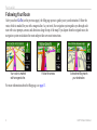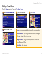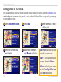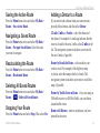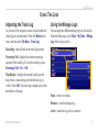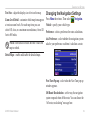
1
GVN 52
owner’s manual
© 2006-2007 Garmin Ltd. or its subsidiaries
Garmin International, Inc.
1200 East 151st Street,
Olathe, Kansas 66062, U.S.A.
Tel. 913/397.8200 or 800/800.1020
Fax 913/397.8282
Garmin (Europe) Ltd.
Liberty House
Hounsdown Business Park,
Southampton, Hampshire, SO40 9RB UK
Tel. +44 (0) 870.8501241 (outside the UK)
0808 2380000 (within the UK)
Fax +44 (0) 870.8501251
Garmin Corporation
No. 68, Jangshu 2nd Road, Shijr,
Taipei County, Taiwan
Tel. 886/2.2642.9199
Fax 886/2.2642.9099
All rights reserved. Except as expressly provided herein, no part of this manual may be reproduced, copied, transmitted, disseminated, downloaded or
stored in any storage medium, for any purpose without the express prior written consent of Garmin. Garmin hereby grants permission to download a
single copy of this manual onto a hard drive or other electronic storage medium to be viewed and to print one copy of this manual or of any revision
hereto, provided that such electronic or printed copy of this manual must contain the complete text of this copyright notice and provided further that any
unauthorized commercial distribution of this manual or any revision hereto is strictly prohibited.
Information in this document is subject to change without notice. Garmin reserves the right to change or improve its products and to make changes in
the content without obligation to notify any person or organization of such changes or improvements. Visit the Garmin Web site (www.garmin.com) for
current updates and supplemental information concerning the use and operation of this and other Garmin products.
Garmin® is a registered trademark of Garmin Ltd. or its subsidiaries and may not be used without the express permission of Garmin.
XM Radio and XM NavTraffic are trademarks of XM Satellite Radio Inc.
August 2007
Part Number 190-00495-12 Rev. B
Printed in Taiwan
Preface
Table of Contents
Warning................................................ iii
Caution.................................................iv
Getting Started............................. 1
Using the Remote Control.....................1
Manual Conventions.............................2
Entering Data........................................2
Find It and Go!............................. 3
Finding a Restaurant . ..........................3
Following Your Route............................4
Where To?.................................... 5
Finding an Address ..............................5
Understanding the Information Page....6
Finding Recently Found Places ...........6
Finding Places in a Different Area.........7
Narrowing Your Search.........................7
GVN 52 Owner’s Manual
My Locations .............................. 8
Adding Stops to Your Route................18
Saving the Active Route......................19
Navigating a Saved Route..................19
Recalculating the Route......................19
Deleting All Saved Routes..................19
Stopping Your Route...........................19
Adding a Detour to a Route................19
Adding Avoidances..............................20
Viewing the Map and Using the
Tools......................................... 13
Using The Logs.......................... 21
Saving Places from the Where To?
Menu...................................................8
Saving Places from the Map.................9
Setting a Home Location.....................10
Finding Saved Places.........................10
Editing Saved Places..........................11
Deleting a Saved Place.......................12
Viewing the Map Page........................13
Trip Computer.....................................14
Turn List..............................................14
GPS Info Page....................................15
Creating and Editing Routes.... 16
Creating a New Saved Route.............16
Editing a Saved Route........................17
Adjusting the Track Log......................21
Using the Mileage Logs......................21
XM Radio, Weather, and
Stocks....................................... 22
Activating Your Subscription...............22
Listening to XM Radio.........................23
Viewing XM Weather...........................26
Viewing Stocks....................................28
Preface
Traffic Information..................... 29
Connecting the Traffic Module............29
Viewing Traffic Events.........................29
Avoiding Traffic....................................30
Severity Color Code............................30
Traffic Symbols...................................31
Changing the Traffic Settings..............31
Adding an FM Traffic Receiver
Subscription......................................32
Changing the Settings.............. 33
Adjusting the Volume..........................33
Changing the General Settings...........33
Changing the Map Settings.................37
Changing the Navigation Settings.......39
Adjusting the Traffic Settings..............40
Viewing Information (About)................40
Restoring the Settings.........................40
ii
Appendix.................................... 41
Using the Remote Control...................41
Updating the Software and Map Data41
Clearing All User Data.........................42
Custom POIs (Points of Interest)........42
Configuring Video Output....................43
Weather Data Warranty......................44
XM Satellite Radio Service Agreement...
45
Software License Agreement..............46
FCC Compliance.................................46
Index........................................... 47
Limited Warranty.................................50
GVN 52 Owner’s Manual
Preface
Warning
This manual uses the term Warning to indicate a potentially hazardous situation, which, if not avoided, could result in death or serious injury.
Failure to avoid the following potentially hazardous situations could
result in an accident or collision resulting in death or serious injury.
When navigating, carefully compare information displayed on the
navigation system to all available navigation sources, including
information from street signs, visual sightings, and maps. For safety,
always resolve any discrepancies or questions before continuing
navigation.
Always operate the vehicle in a safe manner. Do not become distracted
by the navigation system while driving, and always be fully aware of
all driving conditions. Minimize the amount of time spent viewing the
screen of the navigation system while driving and use voice prompts
when possible.
Do not enter destinations, change settings, or access any functions
requiring prolonged use of the navigation system’s controls while
driving. Pull over in a safe and legal manner before attempting such
operations.
Warning: This product, its packaging, and its components contain chemicals known to the State of California to cause cancer, birth defects, or
reproductive harm. This Notice is being provided in accordance with California’s Proposition 65. If you have any questions or would like additional
information, refer to the Garmin Web site at www.garmin.com/prop65.
GVN 52 Owner’s Manualiii
Preface
Caution
This manual uses the term Caution to indicate a potentially hazardous situation, which, if not avoided, may result in minor injury or property damage. It
may also be used without the symbol to alert you to avoid unsafe practices.
Failure to avoid the following potentially hazardous situations may
result in injury or property damage.
The navigation system is designed to provide you with route
suggestions. It does not reflect road closures or road conditions, traffic
congestion, weather conditions, or other factors that may affect safety or
timing while driving.
Use the navigation system only as a navigational aid. Do not attempt
to use the navigation system for any purpose requiring precise
measurement of direction, distance, location, or topography.
The Global Positioning System (GPS) is operated by the United
States government, which is solely responsible for its accuracy and
maintenance. The government’s system is subject to changes which
could affect the accuracy and performance of all GPS equipment,
including the navigation system. Although the navigation system is a
precision navigation device, any navigation device can be misused or
misinterpreted and, therefore, become unsafe.
Important Information
Map Data Information: One of the goals of Garmin is to provide customers with the most complete and accurate cartography that is available to
us at a reasonable cost. We use a combination of governmental and private data sources, which we identify in product literature and copyright messages
displayed to the consumer. Virtually all data sources contain inaccurate or incomplete data to some extent. In some countries, complete and accurate map
information is either not available or is prohibitively expensive.
iv
GVN 52 Owner’s Manual
Getting Started
Getting Started
Using the Remote Control
Your new navigation system comes with a remote control. To use the remote, insert two AAA batteries in the back.
You do not have to aim the remote at a particular location; it should work from anywhere in your vehicle.
(Zoom) In—zooms into the map.
Thumb Stick—highlights options and moves the
map pointer. Press in to select an item on the page.
(Zoom) Out—zooms out of the map.
RF Remote
IN
Menu—opens the Menu page. Press twice to
open the Tools menu. Press three times to open
the Settings menu.
Map—opens the Map page. Press repeatedly to
scroll through the Map, Menu, and XM Music
Player pages.
Back—returns to the previous page and cancels
data entry.
Speak—announces the next turn or the GPS
status.
GVN 52 Owner’s Manual
OUT
ZOOM
MENU
MAP
BACK
SPEAK
PAGE
VOL
1
ABC
2
DEF
3
GHI
4
JKL
5
MNO
6
PQRS
TUV
8
WXYZ
7
0
9
Page ▲ and ▼—scrolls through lists and pages.
Vol + and - —increases and decreases the volume.
Alphanumeric Keys—enters numbers and letters.
To enter letters, press the key repeatedly until the
correct character appears.
(7) and (9)—changes channels in the XM
Music Player.
(0)—plays or stops XM in the XM Music
Player.
If your remote stops working, see page 41.
Getting Started
Manual Conventions
When you are instructed to “press” something, you
should press that button on the remote control.
When you are instructed to “select” something, use
the Thumb Stick on the remote control to move the
highlight (yellow box) to that item on the screen. After
you highlight the object, press the Thumb Stick in to
select it.
Entering Data
Sometimes, you may need to enter letters and numbers
into the navigation system. For example, you may need
to enter the name of a restaurant. To enter letters and
numbers, you can use the on-screen keyboard to select
each letter or number you want to enter. You can also use
the alphanumeric keys on the remote control.
Select to delete
a character.
To select Go To, highlight it.
Then press the Thumb Stick in.
You will see small arrows (>) used in the text. They
indicate that you should select a series of items. For
example, if you see “select Tools > GPS Info > GPS
Settings,” you should select the Tools button, then select
GPS Info, and then select GPS Settings.
Select
Back to exit
this page.
Select 123 to
enter numbers.
Select
to
insert a space.
GVN 52 Owner’s Manual
Find It and Go!
Find It and Go!
Using the remote control, follow the instructions on the next two pages to find a place and go to it!
Finding a Restaurant
➊Select Where To?
➋Select Food, Hotel….
➌ Select Food & Drink.
➍Select a food category.
➎Select a place.
➏Select Go To.
GVN 52 Owner’s Manual
Find It and Go!
Following Your Route
After you select Go To (see the previous page), the Map page opens to guide you to your destination. Follow the
route, which is marked for you with a magenta line. As you travel, the navigation system guides you through each
turn with voice prompts, arrows, and directions along the top of the map. If you depart from the original route, the
navigation system recalculates the route and provides new route instructions.
Your route is marked
with a magenta line.
Follow the arrows.
A checkered flag marks
your destination.
For more information about the Map page, see page 13.
GVN 52 Owner’s Manual
Where to?
Where To?
Finding an Address
➊From the Menu page, select
➋Select a state. Select Search ➌ Enter the address number.
➍Enter the street name. Then
➎Select the street. Select the
Where To? Select Address.
select Done.
All Cities, or select a city.
city, if necessary.
Then select Done.
➏Select the address, if
necessary. Select Go To.
GVN 52 Owner’s Manual
Where to?
Understanding the Information Page
When you find a place, select it in the search results list
to open the item’s Information page.
Finding Recently Found Places
The last 50 places you have found are stored in Recent
Finds. Press Menu to view the Menu page.
➊Select Where To? > Recent Finds.
Information Page
Select Go To to create and follow a route to this place.
Select Advanced to view other options for this place:
•Insert in Current Route—add this place as the next
stop in your route.
•Add As Favorite—add this place to your list of
Favorites. For more information, see page 8.
•Find Near Point—find another place near this place.
•Browse Map—view this place on the map.
➋Select an item from the search results list.
Select Category to display recent finds from a certain
category, such as Food, Hotel….
GVN 52 Owner’s Manual
Where to?
Finding Places in a Different Area
Narrowing Your Search
➊From the search results list, select Near….
➊From the search results list, select Spell.
➋Select one of the search options.
➋Enter part or all of the name. Then select Done.
You can search for locations in a different area, such as a
different city or near your destination.
GVN 52 Owner’s Manual
To narrow your search, you can spell part or all of the
name of the location you are searching for.
My Locations
My Locations
Saving Places from the Where To? Menu
You can save any place you find in the Where To? menu as a Favorite. Then, you can quickly find and go to these
places in the future. After you have found a place you want to save, select it to open the Information page. Then
follow the instructions below.
➊Select Advanced.
➋Select Add As Favorite.
This place is now saved as a Favorite in My Locations. It also appears on the map with a name and symbol. To view a
list of saved places, or to go to a saved place, see page 10.
GVN 52 Owner’s Manual
My Locations
Saving Places from the Map
You can save any place as a Favorite directly from the Map page by browsing the map and selecting the place you
want to save. For more information about browsing the map, see page 13.
Saving Your Current Location
You can save your current location as a Favorite directly from the Map page.
1. Press the Map button to open the Map page.
2. Press the Thumb Stick up, down, right, or left to browse the map.
3. Press the Thumb Stick in to save your current location as a Favorite.
Saving Other Places
Press the Thumb Stick up and then in to
save your current location as a Favorite.
1. Press the Thumb Stick up.
2. Use the Thumb Stick to browse the map and select the place you want to save.
• If you select a labeled place on the map, such as a point of interest, a park, or an
address, the Information page appears. Select Advanced > Add as Favorite to
save this place.
• If you select a place on the map with no label, the navigation system automatically
saves this point in your Favorites and assigns it a name (“001”).
TIP: Check the upper-left corner of the screen. If the screen says “Favorites,” this place is saved as a Favorite.
GVN 52 Owner’s Manual
My Locations
Setting a Home Location
You can set a Home Location for the place you return to most often. Press the Menu button, and select Where To?
➊Select Go Home.
➋Select an option.
➌ Select Save Home.
After you set your Home Location, select Where To? Then select Go Home.
Finding Saved Places
Press the Menu button. Then select Where To?
➋Select Favorites.
➊Select My Locations.
10
➌Select a saved place.
GVN 52 Owner’s Manual
My Locations
Editing Saved Places
Press the Menu button twice. Then select My Data > Favorites.
➊Select Edit/Review Favorites. ➋Select the item you want to edit. ➌Select Edit.
➍Select the item you want to edit.
Name—enter a new name for the location using the on-screen keyboard.
Location—edit the location of the place; you can use the map or enter
new coordinates using the keyboard.
Elevation—enter the elevation of the saved place.
Category—assign this place to a category; select
categories.
to view more
Symbol—select a symbol to be shown on the map for this location.
GVN 52 Owner’s Manual11
My Locations
Deleting a Saved Place
Press the Menu button twice. Then select My Data > Favorites.
➊Select Delete Favorites.
➋Select By Selection.
➌Select a saved location.
➍Select Delete.
By Selection—select each location, and delete it individually.
By Category—select one category to delete all of the locations assigned
to that category.
Delete All—remove all saved places from your Favorites.
12
GVN 52 Owner’s Manual
Viewing the Map and Using the Tools
Viewing the Map and Using the Tools
Viewing the Map Page
Press the Map button on the remote control to view the Map page. You can also select
View Map from the
Menu page. The position icon shows your current location. To zoom in or out on the map, press the In or Out
button. If you want to view another part of the map, use the Thumb Stick, as described below.
Tips for Browsing the Map
•Press the Thumb Stick left, right, up, or down to view
other parts of the map.
•Press the Thumb Stick in to select an object on the
map. The location’s Information page appears; see
page 6 for more information. To go to this location,
select Go To.
•On the Information page, select Advanced > Add as
Favorite to save the location selected by the pointer to
your Favorites. See page 9 for more information.
•When you are finished browsing the map, press the
Back button.
Shows driving directions.
Map Page while Navigating a Route
GVN 52 Owner’s Manual13
Viewing the Map and Using the Tools
Trip Computer
The Trip Computer indicates your current speed and
records helpful statistics about your trip, including your
maximum speed and distance traveled.
Trip Computer, press the Map button
To view the ��������������������������
repeatedly. You can also select Tools > Navigation >
Trip Computer from the Menu page.
Current speed
Current
direction
of travel
Distance to your final
destination
Total
distance
traveled
(odometer)
Select Reset Trip to reset all information on the Trip
Computer. To reset the Maximum Speed, select Reset
Max.
14
Turn List
The Turn List displays a list of turn-by-turn instructions
for your entire route, as well as arrival information.
To display the Turn List, while navigating a route, press
the Map button twice, or select Tools > Navigation >
Turn List from the Menu page.
Direction of this turn
Distance to this turn
Turn directions
Select View All to see all the turns in the route. Select
and
to scroll through the list.
Select a turn to see the turn on a map (the Next Turn
page). Select
and
to scroll through all the
turns in the route. Press the In or Out button to zoom in
or out of the turn on the map.
GVN 52 Owner’s Manual
Viewing the Map and Using the Tools
GPS Info Page
Press the Menu button twice and select Navigation >
GPS Info to view GPS satellite information.
Sky view
GPS Settings
Press Menu three times to open the Settings menu.
Select General > GPS. You can also access the GPS
Settings by selecting the GPS Settings button on the
GPS Info page.
Use Indoors—select Yes to turn the GPS receiver off.
Satellite signal
strength bars
The sky view shows the satellites you are receiving. The
satellite signal strength bars indicate the strength of each
satellite you are receiving. A solid bar indicates the GPS
satellite is ready for use.
Set Position—set your position, if Use Indoors is
enabled. Select your location on the map and then select
OK.
WAAS/EGNOS—disable and enable WAAS/EGNOS.
WAAS and EGNOS are systems of satellites and ground
stations that provide GPS signal corrections, giving you
even better position accuracy. To learn about WAAS and
EGNOS, visit www.garmin.com/aboutGPS/waas.html.
GVN 52 Owner’s Manual15
Creating and Editing Routes
Creating and Editing Routes
Creating a New Saved Route
Press the Menu button twice to open the Tools menu. Select My Data > Routes.
➊Select Create New
➋Select an option, and select ➌Select an option, and select
Saved Route.
Next. Select the starting point.
Next. Select the ending point.
➍To add a stop, select Yes, then ➎Select your preference. .
select Next. Select the point.
16
Then select Next.
➏Select Finish.
GVN 52 Owner’s Manual
Creating and Editing Routes
Editing a Saved Route
Press the Menu button twice. Then select My Data > Routes.
➊Select Edit/Review Routes.
➍Select the item to edit.
➋Select the route to edit.
➌Select Edit.
Rename—enter a new name for the route using the on-screen keyboard.
Edit/Review Points—add, arrange, remove, re-order, and review points
in the route. For more info, see the next page.
Change Preference—change calculation preference to Faster Time,
Shorter Distance, or Off Road.
Delete Route—delete this route.
GVN 52 Owner’s Manual17
Creating and Editing Routes
Adding Stops to Your Route
You can add stops (also called via points or midpoints) to your route as you create it, as described on page 16. You
can also add points to your route when you edit the route, as described below. Follow the steps on the previous page
to begin editing the route.
➊Select Edit/Review Points.
➋Select Add.
➍Search for the point you
➎Add points as necessary.
want to add.
Select Done when finished.
➌Select where you to want to
add the point.
Auto Arrange—arranges the points
to provide the shortest route.
Remove—select the point you want
to remove. Then select Remove.
Re-Order—select the point to move,
and select Move Up or Move Down.
Select Done when finished.
18
GVN 52 Owner’s Manual
Creating and Editing Routes
Saving the Active Route
Press the Menu button twice and select My Data >
Routes > Save Active Route.
Navigating a Saved Route
Press the Menu button twice and select My Data >
Routes > Navigate Saved Route. Select the route
you want to navigate.
Recalculating the Route
Press the Menu button twice and select My Data >
Routes > Recalculate Route.
Deleting All Saved Routes
Press the Menu button twice and select My Data >
Routes >
> Delete All Saved Routes.
Stopping Your Route
Press the Menu button and select Stop. Then select Yes.
Adding �a Detour to a Route
If you need to take a detour from your current route,
press the Menu button, and then select Detour.
1/2 mile, 2 miles, or 5 miles—select the distance of
the detour. For example if a road sign indicates that the
street is closed for the next 2 miles, select 2 miles in the
list. The navigation system recalculates your route for
the next 2 miles, if possible.
Detour by Road(s) In Route—select roads in your
route to avoid. For example, if the highway ramp
is closed, select the ramp in the list of roads. The
navigation system recalculates your route to avoid that
ramp, if possible.
Detour by Traffic Event on Route—if you are using an
FM traffic receiver or XM NavTraffic, you can detour
around traffic events.
Remove All Detours—remove any detours you have
entered for the route.
GVN 52 Owner’s Manual19
Creating and Editing Routes
Adding Avoidances
Press the Menu button three times to open the Settings menu. Select Navigation >
the road type you want to avoid. Select
to view more road types.
Creating Custom Avoids
➊Select Add New Avoid Area. ➋Use the Thumb Stick to
select one corner of the area
you want to avoid.
You can enter specific areas and roads
to avoid in your routes. From the
Avoidance Setup menu, select
two times, and then select Custom
Avoids.
The procedure to the right tells you
how to avoid an area. Avoiding a road
is very similar. When selecting a road
or area to avoid, use the Thumb Stick
to pan the map and select the road
or area to avoid. Use the In and Out
buttons to zoom in and out on the map.
20
> Avoidance Setup. Select
➌Select the second corner of
the area you want to avoid.
➍Press the Thumb Stick in to
save and exit.
GVN 52 Owner’s Manual
Using The Logs
Using The Logs
Adjusting the Track Log
As you travel, the navigator creates a bread crumb trail
(track log) of your movement. Press the Menu button
twice, and then select My Data > Track Log.
Using the Mileage Logs
You can keep four different mileage logs of your travels.
From the Menu page, select Tools > My Data > Mileage
Log. Select a log to edit it.
Recording—turns off and on the track log recorder.
Percentage Full—displays the current percentage
capacity of the track log. To clear the track log, select
Percentage Full > Yes > OK.
Map Display—displays the current track log on the
map. Select a zoom setting at which the track log is
visible. Select OK. Your track log is displayed as a fine
dotted line on the map.
Name—enter a new name.
Distance—reset the mileage log.
Active—make this log active or inactive.
GVN 52 Owner’s Manual
21
XM Radio, Weather, and Stocks
XM Radio, Weather, and Stocks
Activating Your Subscription
If you purchased an optional XM antenna, you must purchase and activate your XM subscription before you can use
the XM features. Make sure your XM antenna is connected. Press the Menu button three times and select About.
➊Select XM.
➋Select Subscribe.
➌Call XM. Then select Next.
➍Select + and - to change the
➎ Select Power Off XM.
If your XM service is not
activated within an hour, you can
refresh the activation signal. Call
XM customer care at 1-800-9859200; or go to www.xmradio.
com /refresh, enter your radio ID
where requested, and refresh the
activation signal.GVN 52 Owner’s Manual
channel. Select Next.
22
XM Radio, Weather, and Stocks
Listening to XM Radio
Note: You must have an XM antenna and a subscription to XM Radio to listen to XM radio. XM Radio is
available only on the U.S. version.
➊Select Tools.
➋Select XM Music Player.
Select
to adjust the volume.
Select
and
Select
and
➌Select Play.
to change Categories. The Category name is listed above the buttons.
to change the Channel within the Category, or press
(7) and
(9).
Select My XM to save or view favorite channels and artists.
Select Browse to select a Category and then a Channel.
Select Play/Stop to turn the XM radio on or off.
GVN 52 Owner’s Manual
23
XM Radio, Weather, and Stocks
Saving Your Favorite Channels as Presets
➊Select My XM.
➌Select Current Channel
to add the channel you are
listening to.
➋Select Add Preset.
➍Select the preset you want to
Saving a Preset
Select a preset button (1–6),
and press and hold the Thumb
Stick in. Keep pressing and
holding until you see a number
appear on the preset button.
The channel you are listening
to is now saved as a preset.
assign to this channel.
Playing a Preset
To play a preset channel,
select a preset button along the
bottom of the XM Radio page.
You can also select Browse >
Presets.
Select Browse by Category to select a different channel.
24
GVN 52 Owner’s Manual
XM Radio, Weather, and Stocks
XM1, 2, and 3
Three sets of presets, XM1, XM2, and XM3, are
provided for you. Within each set of presets, you can
save six favorite channels and as many artists as you
want. For example, Mom can save her favorite channels
and artists using XM1. Then Dad can switch to XM2 and
save his own favorite channels and artists.
To switch between XM1, XM2, and XM3, select My
XM > Change XM Mode. Then select the preset you
want to switch to. The set of presets you are currently
using appears in the top right corner of the screen.
Saving Your Favorite Artists
1.From the XM Radio page, select My XM.
2.Select Add Artist.
3.Select the Current Artist to save the artist you
are listening to. You can also select Browse by
Category to select a different artist.
GVN 52 Owner’s Manual
Scanning for Artists
After you have saved several artists, you can select Scan
to scan the XM Radio for those artists. The navigation
system automatically plays a song by an artist in your
list. When that song is over, it searches for another saved
artist.
➊Select Scan
.
➋Select Artists.
25
XM Radio, Weather, and Stocks
Viewing XM Weather
Press the Menu button twice. Then select
Weather.
Note: You must have an XM antenna and
a subscription to NavTraffic to get traffic and
weather reports.
NOTE: You might have to wait up to 12 minutes
or longer (if receiving a weak XM signal) to
receive the broadcast of weather information.
Getting Current Conditions
3.Select the City. A list of the nearest XM Weather
sources appears. Select any item for more
detailed weather conditions.
4.Select Forecast to jump to the nearest city
forecast page.
Press the Menu button twice and select Weather >
Current Conditions. XM Weather defaults to your
current location.
To select a different city:
1.Select Near > Near Other City.
2.Type the name of the city and select Done.
26
GVN 52 Owner’s Manual
XM Radio, Weather, and Stocks
Viewing Your Forecast
Press the Menu button twice. Then select Weather >
Forecast. XM Weather defaults to your current location.
Select
to view more forecast information. To select
a different city, select Near… and follow the steps in the
previous section.
GVN 52 Owner’s Manual
Checking for County Warnings
Press the Menu button twice. Then select Weather >
County Warnings. This page shows a list of county
warnings in effect, such as storms, tornados, and floods.
Select a warning to view the details. To select a different
city, select Near… and follow the steps in the previous
section.
27
XM Radio, Weather, and Stocks
Viewing Weather on the Map
Press the Menu button twice. Then select Weather
> View On Map. The current weather conditions for
your present location appear on the map. If necessary,
select to zoom out. Select and drag the map to view a
different location.
Select Next to see the forecast for the next day on the
map. For more weather information, position the map
pointer over a weather icon, and then select Review.
28
Viewing Stocks
Press the Menu button twice and select
view current stock prices.
Stocks to
To add a stock, select Add Stock, enter the stock symbol
(abbreviation), and select Done. The stock you added is
now listed.
To delete a stock, select the stock in the list. Then select
Yes.
GVN 52 Owner’s Manual
Traffic Information
Traffic Information
Using an optional FM traffic receiver or XM smart
antenna, the navigation system can receive and use
traffic information. When a traffic message is received,
you can see the event on the map and change your route
to avoid the traffic incident.
For more information about the FM traffic receiver or
XM smart antenna, visit the Garmin Web site
(www.garmin.com). For participating FM subscription
providers and covered cities, refer to www.garmin.com
/fmtraffic. For coverage cities for XM NavTraffic, see
www.xmnavtraffic.com.
This section uses “traffic module” to describe the
external device that receives traffic information. You can
use either an FM traffic receiver (such as the GTM 10) or
an XM smart antenna (such as the GXM 30) to receive
traffic information.
Connecting the Traffic Module
Make sure the traffic module is connected to the
navigation system. Refer to the GVN 52 Installation
Guide for more information.
Viewing Traffic Events
Press the Menu button twice and select Traffic Info.
Select an item in the Traffic Events list to view the
details. Select Near… to view traffic at a different
location.
Traffic symbol
Color
code
Traffic Events List
GVN 52 Owner’s Manual
Traffic
source
(FM or
XM) and
signal
strength
29
Traffic Information
Avoiding Traffic
The Map page displays a
when there is a traffic event on your current route or on the road where you are driving.
When you are following a route, press the Thumb Stick in on the Map page to select the
and avoid traffic.
➊Press the Thumb Stick in.
➋Select an item to avoid.
➌Select Detour Around.
Severity Color Code
The bars to the left of the traffic symbols indicate the severity of the traffic incident:
(Green) = Low severity; traffic is still flowing.
(Yellow) = Medium severity; traffic is a bit congested.
(Red) = High severity; traffic is heavily congested or stopped.
30
GVN 52 Owner’s Manual
Traffic Information
Traffic Symbols
North
American
Symbols
Meaning
International
Symbols
Road Condition
Road Construction
Congestion
Accident
Incident
Information
Changing the Traffic Settings
From the Menu page, select Settings > Traffic.
Subscriptions—view your traffic subscriptions. If you
have an FM traffic receiver connected, select FM Traffic
Subscriptions to view your subscriptions. Select the
subscription to display the expiration date. To add a
subscription, select Add Subscription. See the next page
for information about adding an FM traffic subscription.
If you have an XM smart antenna connected, select
XM Subscriptions to view the software version, your
XM subscriptions, and the antenna’s radio ID. Select
Subscribe to add an XM subscription.
Symbols on Map—change the symbols used to indicate
the type of traffic event. Select Style to use American
or International symbols. Select each symbol to set the
zoom scale at which each symbol appears on the map.
Severity on the Map—select the scale at which the
severity is displayed on the map.
Audio Notification—turn on or off the audio notification
when a traffic incident occurs on the road you are
traveling on or the route you are navigating.
Avoid Traffic—select Yes to avoid a traffic incident
when generating a route.
GVN 52 Owner’s Manual31
Traffic Information
Adding an FM Traffic Receiver Subscription
To add a traffic subscription, press the Menu button three times to open the Settings menu. Select About > FM
Traffic Receiver. Then write down your FM traffic receiver’s unit ID. Go to www.garmin.com/fmtraffic to purchase
a traffic subscription and get a 25-character traffic subscription code.
➊Select Settings.
➋Select Traffic.
➌Select
➎Select Next.
➏Enter the code and
➐Select OK.
32
select Next.
Subscriptions.
➍Select Add
Subscription.
GVN 52 Owner’s Manual
Changing the Settings
Changing the Settings
Adjusting the Volume
Press Menu to open the Menu page. Then select
Volume. Select the
and
to adjust the volume.
Select Mute to silence the audio output.
Select Settings to open the Audio Settings page. See
page 34 for more information.
Select Advanced to adjust the volume levels of the
navigation prompts and XM radio separately.
Changing the General Settings
Press Menu three times to open the Settings menu. Then
select General.
GPS
Press Menu three times. Then select General > GPS.
See page 15.
Changing the Language
Press Menu three times. Then select General >
Language.
GVN 52 Owner’s Manual33
Changing the Settings
Voice Language—change the language for all voice
prompts and messages. Select the voice you want to use
and select OK.
Text Language—select a language for the on-screen
text. Changing the text language does not change the
language of map data or user-entered data.
Two different types of voice languages are available:
text-to-speech and prerecorded.
Speech Rate—select the rate at which prompts are
spoken.
Languages noted with a person’s name and (TTS) are
text-to-speech (TTS) voices: for example, American
English-Jill (TTS) is a text-to-speech voice. The textto-speech voices “read” and “speak” the same words
that are displayed on the screen. The voices have an
extensive vocabulary, and they pronounce the street
names as you approach turns.
Customizing the Keyboard Settings
Press Menu three times. Then select General > Keyboard.
Input Type—select English Only keyboard, or select
Western European to use diacritical characters.
Entry Type—select ABCDEF keyboard, or select
QWERTY.
Languages without a person’s name are prerecorded
voices, which have a limited vocabulary and do not
speak names of locations or streets.
NOTE: If you change the Voice Language, you
must restart to complete this change.
34
GVN 52 Owner’s Manual
Changing the Settings
Customizing the ���������������
Audio Settings
Customizing Proximity Alerts
Guidance—turn on the vocal guidance prompts. Select
Speak Key Only to hear the voice prompts only when
you press the SPEAK key on the remote control.
Changing Your Time Settings
Press Menu three times. Then select General > Audio.
Attention Tone—turn the attention tone on or off that
sounds before voice prompts.
Touch Screen Tone—turn on or off the tone that sounds
each time you select something on the screen.
Keypress Tone—turn on or off the tone that sounds each
time you press a button on the remote.
Speed Adjusted Volume—select how much the volume
increases as your speed increases. Low increases your
volume slightly; High increases your volume the most.
Press Menu three times. Then select General >
Proximity Alerts to adjust the notifications for custom
POIs you have loaded. See pages 41–42.
Press Menu three times. Then select General > Time.
Time Zone—select your time zone.
Time Format—select 12- or 24-hour time format.
Daylight Saving—select Auto, Yes, or No. The Auto
setting automatically adjusts the time for daylight saving,
based on your time zone.
Selecting Units
Press Menu three times. Then select General > Units.
Change units of measure to Statute, Metric, or Custom.
GVN 52 Owner’s Manual35
Changing the Settings
Turning Safe Mode Off and On
Press Menu three times. Then select General > Safe
Mode. When Safe Mode is turned on and the vehicle
is moving, Safe Mode disables all navigation system
functions that require significant operator attention and
could become a distraction while driving.
Changing the Coordinates Settings
Press Menu three times. Then select General >
Coordinates.
Position Format—change the appearance of your
coordinates. Your current position is viewed on the GPS
in the form of coordinates. Because different maps and
charts use different position formats, you can choose the
correct coordinate system for the type of map you are
using.
36
Map Datum—select the map datum to be used by your
GVN 52. If you are navigating and comparing the GPS
coordinates to a map, chart, or other reference, set the
map datum in your GVN 52 to the same datum as the
map to ensure the most accurate navigation.
Setting Audio Mute Polarity
Press Menu three times. Then select General > Audio
Mute Polarity. This is used for muting your radio when
your GVN 52 plays navigation prompts. Select Low or
High, depending on your radio configuration. See your
radio’s instruction manual for more information.
Note: This setting is used only on radios that can
switch to Aux audio based on an external signal.
GVN 52 Owner’s Manual
Changing the Settings
Changing the Map Settings
Press Menu three times. Then select
Map.
Map Detail—adjust the amount of detail shown on the
map. Displaying more detail causes the map to redraw
slowly.
Orientation—change the perspective of the map.
• 2D North Up—display the map in 2 dimensions
(2-D) with North at the top.
•2D Track Up—display the map in 2 dimensions
(2-D) with your direction of travel at the top of the
screen.
•3D Track Up—display the map in 3 dimensions
(3-D), with your direction of travel at the top of the
screen. This is the default map view.
Color Mode—select Day for a bright background.
Select Night for a black background. Select Auto to
automatically switch between the two.
Auto Zoom—disable or enable automatic zooming on the
map for optimal viewing. You can also specify a maximum
Auto Zoom distance, from 120 feet to 300 miles.
Route Color—select the color of the route line.
Dim Roads—dim roads that are not on your route. You
can customize this setting to Never or While Routing.
GVN 52 Owner’s Manual37
Changing the Settings
Map Data Fields—customize the width and contents of the data fields displayed on the map page. Normal is the
default setting. Press Menu three times. Then select
Map >
> Map Data Fields.
➊Select Thin or Wide.
Select Next.
➋Select the type of data ➌Select a data field you
fields to customize.
➍Select the type of data ➎Select the data field
you want to see.
38
layout. Select OK.
want to change.
➏Repeat for each field.
Then select Finish.
1/2, 2/2, 1/3?
1/2 indicates this
is your first choice
out of two choices
for the layout of
the data field. 2/2
means this is your
second choice.
Some types of data
fields allow you
three choices, but
some only provide
one.
GVN 52 Owner’s Manual
Changing the Settings
Text Size—adjust the display size of text on the map.
Zoom Level Detail—customize which map items appear
at various zoom levels. For each map item, you can
select Off, Auto, or a maximum zoom distance, from 120
feet to 800 miles.
Note: More detail increases the time it takes the
map to refresh.
Changing the Navigation Settings
Press Menu three times. Then select
Navigation.
Vehicle—specify your vehicle type.
Preference—select a preference for route calculations.
Ask Preference—select whether the navigation system
asks for your preference each time it calculates a route.
Detail Maps—enable and disable the detailed maps.
Next Turn Pop-up—select when the Next Turn pop-up
window appears.
Off-Route Recalculation—set the way the navigation
system responds when off the route. You can silence the
“off-route, recalculating” message here.
GVN 52 Owner’s Manual39
Changing the Settings
Continuous Auto Routing—enable or disable the
Continuous Auto Routing feature. This feature allows
the navigation system to continually search for a better
route to your destination. Continuous Auto Routing may
be useful if a traffic accident occurs or there are timerestricted turns on the current route. A
is displayed
on the map when a better route than the one you are
currently taking is available. Press the Thumb Stick in
on the Map page to select the
and take the better
route.
Viewing �������������
Information �������
(About)
Press Menu three times. Then select
About.
Software—the unit’s software version, audio version,
and unit ID are listed.
Detail Maps—view information about the preloaded
detailed maps.
FM Traffic Receiver—if you have a FM traffic receiver,
you can view the FM traffic receiver’s unit ID.
Avoidance Setup—see page 20.
XM—if you have an XM smart antenna, you can view
the XM antenna’s radio ID.
Adjusting the Traffic Settings
Restoring the Settings
See page 31.
40
To restore the navigation system to its original settings,
press Menu three times. Then select Restore Defaults >
Yes.
GVN 52 Owner’s Manual
Appendix
Appendix
Using the Remote Control
The remote control uses two AAA batteries. Do not mix
old and new batteries together. If the remote does not
work, install fresh batteries. If this does not correct the
problem, you can re-pair the remote control with the
GVN 52. You must also follow this procedure to use a
replacement remote control.
To pair your remote with the GVN 52:
1.Press and hold the Thumb Stick and the 0 key on
the remote for 10 seconds.
2.Follow the instructions
on the screen; enter the
correct numbers. The
remote control pairs with
the GVN 52.
Updating the Software and Map Data
To update the navigation system software, you must
have an SD card, an SD card reader, and an Internet
connection.
To update the navigation software:
1. Go to www.garmin.com/support/download.jsp.
2. Click Additional Software.
3. Select GVN 52 from the list of products.
2. Click Download next to the navigation system software.
3. Read and agree to the terms. Click Download.
4. Select Save. Then save the update onto an SD card.
5. Insert the SD card into the side of the GVN 52. Make
sure the system is powered on. Your software is updated
automatically.
You can purchase map data updates from Garmin. Check
www.garmin.com/unlock/update.jsp to see if an update
for your map software is available.
GVN 52 Owner’s Manual41
Appendix
Clearing All User Data
You can clear all user data, including all Favorites,
routes, custom POIs, tracks, mileage logs, and your
home location, at one time.
CAUTION: You cannot recover your user data
after it is deleted.
To clear all user data:
1. Select Tools > My Data > Clear All.
2. Select Yes. The navigation system restarts.
Custom POIs (Points of Interest)
You can manually load custom points of interest (POI)
databases, available from various companies on the
Internet. Some custom POI databases contain alert
information for points such as safety cameras and school
zones. The navigation system can notify you when you
approach one of these points.
42
Caution: Garmin is not responsible for the
consequences of using a custom POI database or
the accuracy of the safety camera or other custom
POI database.
After downloading your POI database, use the Garmin
POI Loader to install the POIs onto an SD card. Then,
you can use the SD card to load the POIs into the
navigation system. The POI Loader is available at
www.garmin.com/products/poiloader. Refer to the POI
Loader Help file for more information; press F1 to open
the Help file.
When you insert the SD card into the navigation system,
a message appears on the screen, prompting you to save
the custom POIs to your navigation system. Select Yes.
If you select No, custom POIs do not work.
Note: Each time you load custom POIs to the
navigation system, any other custom POIs already
saved in the system are overwritten.
GVN 52 Owner’s Manual
Appendix
Finding Custom POIs
To view a list of the custom POIs loaded in your
navigation system, select Tools > My Data > Custom
POIs.
Adjusting the Proximity Alerts
To turn on or off the proximity alerts for custom POIs,
press the Menu button three times and select General >
Proximity Alerts.
Audio Notification—turn off or on the alerts that sound
as you approach a custom POI.
Visual Notification—turn off or on the pop-up alerts
that appear as you approach a custom POI.
Continuous Notification—select which alerts (which
types of POIs) you want to be continually notified of.
Deleting All Custom POIs
To delete all custom POIs from your navigation system,
press the Menu button twice and select My Data >
Custom POIs > Delete All. Select Yes to confirm.
Configuring Video Output
You can switch the composite video output mode from
NTSC (National Television System Committee) to PAL
(Phase Alternate Line) by using the switch beside the
SD card slot. Push the switch all the way to the right to
change the composite video mode to PAL (Asian and
North American versions do not have this feature).
nOTE: NTSC is the default setting. Use NTSC
unless your system works exclusively with PAL.
After you change the composite video mode, you must
turn off your vehicle and turn it back on again to reboot
the system before the changes take effect.
GVN 52 Owner’s Manual43
Appendix
Weather Data Warranty
THE WEATHER DATA SOFTWARE PRODUCT IS PROVIDED
“AS IS.” ALL OTHER WARRANTIES, EXPRESSED OR IMPLIED,
INCLUDING ANY WARRANTY OF MERCHANTABILITY OR
FITNESS FOR A PARTICULAR PURPOSE OR OF
NON-INFRINGEMENT ARE HEREBY EXCLUDED.
User Safety
If you use XM Services it is your responsibility to exercise prudent
discretion and observe all safety measures required by law and your
own common sense. You assume the entire risk related to your use of
the Services. XM and Garmin assume no responsibility for accidents
resulting from or associated with use of the Services. Your Radio Service
includes traffic and weather information, and you acknowledge that
such information is not for “safety for life”, but is merely supplemental
and advisory in nature, and therefore cannot be relied upon as safetycritical in connection with any aircraft, sea craft or automobile usage.
This information is provided “as is” and XM and Garmin disclaim
any and all warranties, express and implied, with respect thereto or the
transmission or reception thereof. XM and Garmin further do not warrant
the accuracy, reliability, completeness or timeliness of the traffic and
weather information disclosed on the Radio Service. In no event will XM
and Garmin, their data suppliers, service providers, marketing/distribution,
software or Internet partners or hardware manufacturers be liable to you
or to any third party for any direct, indirect, incidental, consequential,
44
special, exemplary or punitive damages or lost profits resulting from use
of or interruptions in the transmission or reception of the Services.
Limits On Our Responsibility
a) DISCLAIMERS.
EXCEPT AS EXPRESSLY PROVIDED HEREIN, WE MAKE NO
WARRANTY OR REPRESENTATION, EITHER EXPRESS OR
IMPLIED, REGARDING THE RADIO SERVICE. YOUR USE OF
THE SERVICE IS AT YOUR SOLE RISK. THE CONTENT AND
FUNCTIONALITY OF THE SERVICE IS PROVIDED “AS IS”
WITHOUT ANY WARRANTY OF ANY KIND, EXPRESS OR
IMPLIED. ALL SUCH WARRANTIES OR REPRESENTATIONS
(INCLUDING, WITHOUT LIMITATION, THE IMPLIED
WARRANTIES OF MERCHANTABILITY, FITNESS FOR A
PARTICULAR PURPOSE, TITLE AND NON-INFRINGEMENT) ARE
HEREBY DISCLAIMED.
b) LIMITATIONS OF LIABILITY.
WE ARE NOT RESPONSIBLE FOR ANY SPECIAL, INCIDENTAL,
OR CONSEQUENTIAL DAMAGES OR LOSSES RELATING TO
THE USE OF THE RADIO SERVICE, WHETHER BASED ON
NEGLIGENCE OR OTHERWISE. OUR TOTAL LIABILITY TO
YOU AND ANY OTHER PERSONS RECEIVING OUR SERVICES,
REGARDLESS OF THE CAUSE, WILL IN NO EVENT EXCEED
THE AMOUNTS THAT YOU HAVE PAID TO US FOR THE SERVICE
GVN 52 Owner’s Manual
Appendix
THAT YOU RECEIVED DURING THE SIX (6) MONTH PERIOD
IMMEDIATELY PRIOR TO THE SPECIFIC EVENT THAT GAVE RISE
TO THE APPLICABLE DAMAGE OR LOSS. THIS ALLOCATION OF
RISK IS REFLECTED IN OUR PRICES. YOU MAY HAVE GREATER
RIGHTS THAN DESCRIBED ABOVE UNDER YOUR STATE’S
LAWS
This product was developed using DAFIF™, a product of the National
Geospatial-Intelligence Agency.
This product has not been endorsed or otherwise approved by the National
Geospatial-Intelligence Agency, or the United States Department of
Defense (10 U.S.C. 425).
a. Under 10 U.S.C. 456, no civil action may be brought against the
United States on the basis of the content of a navigational aid prepared
or disseminated by either the former Defense Mapping Agency (DMA),
National Imagery and Mapping Agency (NIMA), or the National
Geospatial-Intelligence Agency (NGA).
c. Neither NGA nor its personnel will be liable for any claims, losses, or
damages arising from or connected with the use of this product. The user
agrees to hold harmless the United States National Geospatial-Intelligence
Agency. The user’s sole and exclusive remedy is to stop using the DAFIF
product.
XM Satellite Radio Service Agreement
XM Satellite Radio Inc.
Hardware and required monthly subscription sold separately. Subscription
fee is consumer only. Other fees and taxes, including a one-time activation
fee may apply. All programming fees and weather data subject to change.
XM weather data displays and individual product availability vary by
hardware equipment. Reception of the XM signal may vary depending
on location. Subscriptions subject to Customer Agreement included with
the XM Welcome Kit and available at www.xmradio.com. Available only
in the 48 contiguous United States. XM is a trademark of XM Satellite
Radio Inc.
b. The DAFIF product is provided “as is,” and no warranty, express
or implied, including, but not limited to the implied warranties of
merchantability and fitness for particular purpose or arising by statute or
otherwise in law or from a course of dealing or usage in trade, is made by
NGA as to the accuracy and functioning of the product.
GVN 52 Owner’s Manual45
Appendix
Software License Agreement
BY USING THE GVN 52, YOU AGREE TO BE BOUND BY THE
TERMS AND CONDITIONS OF THE FOLLOWING SOFTWARE
LICENSE AGREEMENT. PLEASE READ THIS AGREEMENT
CAREFULLY.
Garmin grants you a limited license to use the software embedded in this
device (the “Software”) in binary executable form in the normal operation
of the product. Title, ownership rights, and intellectual property rights in
and to the Software remain in Garmin.
You acknowledge that the Software is the property of Garmin and
is protected under the United States of America copyright laws and
international copyright treaties. You further acknowledge that the
structure, organization, and code of the Software are valuable trade secrets
of Garmin and that the Software in source code form remains a valuable
trade secret of Garmin. You agree not to decompile, disassemble, modify,
reverse assemble, reverse engineer, or reduce to human readable form the
Software or any part thereof or create any derivative works based on the
Software. You agree not to export or re-export the Software to any country
in violation of the export control laws of the United States of America.
FCC Compliance
The unit complies with Part 15 of the FCC interference limits for Class B
digital devices FOR HOME OR OFFICE USE. These limits are designed
to provide more reasonable protection against harmful interference
in a residential installation, and are more stringent than “outdoor”
requirements.
This equipment generates, uses, and can radiate radio frequency energy
and may cause harmful interference to radio communications if not
installed and used in accordance with the instructions. However, there is
no guarantee that interference will not occur in a particular installation.
If this equipment does cause harmful interference to radio or television
reception, which can be determined by turning the equipment off and
on, the user is encouraged to try to correct the interference by one of the
following measures:
•Reorient or relocate the receiving antenna.
•Increase the separation between the equipment and the receiver.
•Connect the equipment into an outlet on a circuit different from that to
which the receiver is connected.
•Consult the dealer or an experienced radio/TV technician for help.
Industry Canada Compliance
This Category II radiocommunication device complies
with Industry Canada Standard RSS-310.
46
GVN 52 Owner’s Manual
Index
Index
Symbols
2 dimensional 37
3 dimensional 37
A
adding an XM subscription 22
adding a traffic subscription 32
add as Favorite 6
audio mute polarity 36
audio version 40
auto arrange, route 18
avoidances 20
avoiding traffic 30
B
better route 40
browse the map 13
C
category for saved locations 11
changing settings 33–40
general settings 33
map settings 37
navigation settings 39
restoring the settings 40
volume 33
color mode 37
continuous auto routing 40
coordinates, entering 11
coordinates settings 36
custom avoids 20
custom POIs 42
D
data fields
customizing 38
default settings 40
deleting
all saved routes 19
My Favorites 12
routes 17
saved locations 12
detour, adding 19
driving directions 14
G
E
H
edit/review points 17
editing saved places 11
EGNOS 15
elevation, entering 11
expanding your search 7
F
finding places 5–7
address 5
recent finds 6
restaurant 3
saved places 10
spell the name 5
find near point 6
following your route 4
general settings 33
Go Home 10
GPS info page 15
home location 10
I
input type 34
insert point in current route 6
items to avoid 40
K
keyboard entry type 34
ABCDEF 34
QWERTY 34
keyboard settings 34
L
language 33
license agreement 46
location of saved place,
editing 11
GVN 52 Owner’s Manual47
Index
M
map 13
browse 13
customize 37
orientation 37
update maps 41
zoom 14
map datum 36
metric units 35
midpoints in the route 18
mileage logs 21
My Locations 8–12
Go Home 10
My Favorites 10
Recent finds 6
N
name of a saved place 11, 17
narrowing your search 7
navigating a saved route 19
navigation settings 39
Near button 7
north up 37
48
O
odometer 14
off-route voice 39
original settings 40
P
PAL 43
places
editing 11
finding 5–7
saving 8
position format 36
position icon 13
proximity alert 43
R
re-order points in route 18
recalculating the route 19
recently found places 6
remove all detours 19
remove points from route 18
rename
route 17
saved location 11
reset
max. speed 14
mileage log 21
settings 40
trip computer 14
restoring settings 40
routes 16–20
add point 6
create new 16
detour 19
edit a saved route 17
navigate a saved route 19
save the active route 19
stop 19
routing preferences 39
S
safe mode 36
saved places
deleting 12
editing 11
finding 10
saved routes
adding points to 18
deleting 17, 19
editing 17
navigating 19
saving places you find 8
saving the active route 19
scanning XM Radio 25
set position 15
software license agreement 46
software version 40
speed (Speedometer) 14
spell 7
stops in the route 18
stop navigation 19
symbol for locations 11
GVN 52 Owner’s Manual
Index
T
text language 34
time 35
track log 21
track up 37
traffic
avoid 30
events 29
traffic information 29–32
trip computer 14
turn list 14
U
unit ID
FM traffic receiver 40
software 40
XM 40
use indoors 15
V
vehicle type 39
via points 18
video input 43
viewing the map 13
voice language 34
volume 33
W
Weather Data Warranty 44
Where To? 5–7
X
XM 19, 29, 33
radio ID 40
scanning
25
XM1, XM2, XM3
22
Z
zoom 14
GVN 52 Owner’s Manual49
Limited Warranty
This Garmin product is warranted to be free from defects in materials or
workmanship for one year from the date of purchase. Within this period, Garmin
will at its sole option repair or replace any components that fail in normal use.
Such repairs or replacement will be made at no charge to the customer for parts
or labor, provided that the customer shall be responsible for any transportation
cost. This warranty does not cover failures due to abuse, misuse, accident or
unauthorized alteration or repairs.
THE WARRANTIES AND REMEDIES CONTAINED HEREIN ARE
EXCLUSIVE AND IN LIEU OF ALL OTHER WARRANTIES EXPRESS
OR IMPLIED OR STATUTORY, INCLUDING ANY LIABILITY ARISING
UNDER ANY WARRANTY OF MERCHANTABILITY OR FITNESS FOR A
PARTICULAR PURPOSE, STATUTORY OR OTHERWISE. THIS WARRANTY
GIVES YOU SPECIFIC LEGAL RIGHTS, WHICH MAY VARY FROM STATE
TO STATE.
IN NO EVENT SHALL GARMIN BE LIABLE FOR ANY INCIDENTAL,
SPECIAL, INDIRECT OR CONSEQUENTIAL DAMAGES, WHETHER
RESULTING FROM THE USE, MISUSE, OR INABILITY TO USE THIS
PRODUCT OR FROM DEFECTS IN THE PRODUCT. Some states do not allow
the exclusion of incidental or consequential damages, so the above limitations
may not apply to you.
Garmin retains the exclusive right to repair or replace the unit or software or
offer a full refund of the purchase price at its sole discretion. SUCH REMEDY
SHALL BE YOUR SOLE AND EXCLUSIVE REMEDY FOR ANY BREACH
OF WARRANTY.
To obtain warranty service, contact your local Garmin authorized dealer or call
Garmin Product Support for shipping instructions and an RMA tracking number.
50
The unit should be securely packed with the tracking number clearly written on
the outside of the package. The unit should then be sent, freight charges prepaid,
to any Garmin warranty service station. A copy of the original sales receipt is
required as the proof of purchase for warranty repairs.
Garmin International, Inc.
Tel. 913/397.8200, Fax. 913/397.8282
Garmin (Europe) Ltd.
Tel. 44/0870.8501241, Fax 44/0870.8501251
Online Auction Purchases: Products sold through online auctions are not eligible
for rebates or other special offers from Garmin. Online auction confirmations are
not accepted for warranty verification. To obtain warranty service, an original
or copy of the sales receipt from the original retailer is required. Garmin will
not replace missing components from any package purchased through an online
auction.
International Purchases: A separate warranty is provided by international
distributors for units purchased outside the United States. This warranty is
provided by the local in-country distributor and this distributor provides local
service for your unit. Distributor warranties are only valid in the area of intended
distribution. Units purchased in the United States or Canada must be returned to
the Garmin service center in the United Kingdom, the United States, Canada, or
Taiwan for service.
The GVN 52 has no user-serviceable parts. Should you ever encounter a problem
with your unit, please take it to an authorized Garmin dealer for repairs.
The GVN 52 is fastened shut with screws. Any attempt to open the case to
change or modify the unit in any way will void your warranty and may result in
permanent damage to the equipment.
GVN 52 Owner’s Manual
For the latest free software updates (excluding map data) throughout the life of your
Garmin products, visit the Garmin Web site at www.garmin.com.
© Copyright 2006-2007 Garmin Ltd. or its subsidiaries
Garmin International, Inc.
1200 East 151st Street, Olathe, Kansas 66062, U.S.A.
Garmin (Europe) Ltd.
Liberty House, Hounsdown Business Park, Southampton, Hampshire, SO40 9RB UK.
Garmin Corporation
No. 68, Jangshu 2nd Road, Shijr, Taipei County, Taiwan
www.garmin.com
Part Number 190-00495-12 Rev. B