1
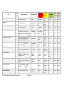
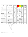
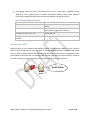
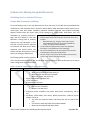
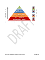
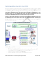
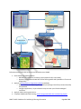
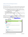
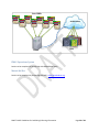
Draft Guidelines for Publishing and Sharing Information Central US Earthquake Consortium (CUSEC), CAPSTONE 2014 Exercise Contents Contents ........................................................................................................................................................ 1 Introduction .................................................................................................................................................. 3 Essential Elements of Information ............................................................................................................ 3 Overview of Technology Capabilities ........................................................................................................ 6 Guidance for Incident Management Information Systems .......................................................................... 8 Sharing from WebEOC .............................................................................................................................. 8 Sharing from EMITS .................................................................................................................................. 9 Guidance for Sharing Geospatial Resources ............................................................................................... 10 Publishing Services with ArcGIS Server ................................................................................................... 10 Prepare Map Document for publishing .............................................................................................. 10 Map Services Folder Structure ............................................................................................................ 11 Map Service Naming Pattern .............................................................................................................. 11 Sharing Content with ArcGIS Online ....................................................................................................... 12 Guidelines for all items ....................................................................................................................... 13 Adding Existing Map Services ............................................................................................................. 14 Publishing Hosted Feature Services .................................................................................................... 14 Symbology ............................................................................................................................................... 18 Publishing and Receiving Alerts from IPAWS .............................................................................................. 21 Guidance for Resource Management Systems ........................................................................................... 24 Mutual Aid Support System .................................................................................................................... 24 EMAC Operations System ....................................................................................................................... 26 Mutual Aid Net........................................................................................................................................ 26 APPENDICES ................................................................................................................................................ 27 CAPSTONE 2014 Ready Document ......................................................................................................... 27 DRAFT CUSEC Guidelines for Publishing & Sharing Information Page 1 of 28 ArcGIS Online for CUSEC Getting Started Document.............................................................................. 27 Situational Awareness Symbology Brief ................................................................................................. 27 vUSA Standardized Items Tags ................................................................................................................ 27 vUSA National Information Sharing Agreement ..................................................................................... 27 NIMS Resource Types ............................................................................................................................. 27 Mission Ready Package (MRP) Resource Types ...................................................................................... 27 NIEM IEPD Data Models.......................................................................................................................... 27 DRAFT CUSEC Guidelines for Publishing & Sharing Information Page 2 of 28 Introduction Capstone 2014 is a multi-year New Madrid Seismic Zone earthquake exercise organized around the Central US Earthquake Consortium (CUSEC). The intent of this document is to provide the CUSEC region with guidance on publishing and sharing geospatial information for the CAPSTONE 2014 Exercise. During this exercise, each CUSEC member state will create and share a predetermined list of Essential Elements of Information (EEI) (see appendix) with the rest of the consortium. The CUSEC Member States and Associate States will publish and share the EEIs for the CAPSTONE 2014 Exercise so that they are accessible to the appropriate users and groups across the consortium. Rather than serve as a definitive standard to meet every expected need, this document is intended to provide practical guidance which can be adapted by individual CUSEC members as is practical within their organizations. By approaching the process of publishing and sharing information in a coordinated, systematic, standardsbased process, CUSEC Member and CUSEC Associate States will be able to more effectively access and use the set of EEIs during the Capstone 2014 disaster planning Figure 1. CUSEC Member States exercise, as well as for other events requiring intra/interstate information sharing and coordination. To improve information sharing during the Capstone 2014 Exercise, it is important that information is published from an organization’s individual technology/information sharing platforms in a consistent manner. Below are series of guidelines, specific to key data publishing platforms, for effectively staging the content that you want to share. Essential Elements of Information The objective of Capstone 2014 is to develop, codify, and share a set of Essential Elements of Information (EEI) for specific operational needs. These EEIs will be the primary information shared during the exercise. The proposed set of 17 EEIs are included in the following table, along with the Feature Type (point, line, or polygon), Required/Minimum Attributes, Responsible ESF, and the definitions for the status indicators (green/yellow/red). DRAFT CUSEC Guidelines for Publishing & Sharing Information Page 3 of 28 Table 1. Draft EEI List EEI Electricity Grid Natural Gas Grid Public Water Grid Road Status (including bridges) Rail network (including bridges) Navigable waterways Feature Type Required Attributes Responsible ESF Status Red Status Yellow 12-Energy No availability Limited availability Available Unknown Inactive Power type, name, location. 12-Energy No availability Limited availability Available Unknown Inactive Power type, name, location. 12-Energy No availability Limited availability Available Unknown Inactive 1-Transportation Major delays or closed Minor delays due to road conditions Passable Unknown Inactive Passable Unknown Inactive Passable Unknown Inactive Open Unknown Inactive Level 3operational/mo nitoring Unknown Inactive Open Unknown Inactive Open Unknown Inactive Open Unknown Inactive Road name, location (e.g. mile marker; lat/long; address; intersection), type (i.e. bridge, broken pavement, sinkhole), distance of closure. Location (e.g. mile marker; lat/long; address; intersection), type (i.e. bridge, broken pavement, sinkhole), distance of closure. 1-Transportation Major delays or closed Location (e.g., river mile; lat/long), Name, type (e.g., debris closure...). 1-Transportation Major delays or closed Airport name, location (lat/long; address). 1-Transportation Closed Name of EOC, address/location, primary phone number, status. 5-Emergency Management Level 1-full activation Name, address/location, primary phone number, POC, Type (e.g., vehicle, personnel, equipment). 5-Emergency Management Closed Name, address/location, primary phone number, POC. ? Closed JRSOI Name, Address, POC, Capacity. 5-Emergency Management Closed Minor delays due to road conditions Minor delays due to road conditions Limited use/emergency use only Area Command Locations Points of Distribution (PODS) Joint Reception, Staging, Onward Movement and Integration (JRSOI) Sites Status Status Unknown Inactive Power type, name, location. Air Transportation Infrastructure Staging Areas Status Green DRAFT CUSEC Guidelines for Publishing & Sharing Information Page 4 of 28 Level 2-partial activation Limited use/emergency use only Limited use/emergency use only Limited use/emergency use only EEI Evacuation Orders Injuries and Fatalities Shelters Private Sector Infrastructure US Geological Survey Data (e.g., Prompt Assessment of Global Earthquakes for Response or PAGER) Communications (Public Safety and General Public) Hospital Status Feature Type Required Attributes Responsible ESF Status Red Status Yellow Status Green Status Status Unknown Inactive None Unknown Inactive No fatality reports Unknown Inactive County name, Incident name, alert type, threat level, area of concern, POC. 5-Emergency Management Mandatory County name, number of reports, time last updated. 8-Public Health and Medical Services Confirmed fatalities/ injuries Voluntary/phase d Fatality/injury confirmation underway Name, address, max capacity, current capacity; NSS and FEMA shelter data required. 6-Mass Care-Emergency Assistance-HousingHuman Services Full or over capacity Open-more than 50% occupancy Open-less than 50% occupancy or Closed Unknown Inactive Retailer name/type, location, POC. Other Not Available Deployed Available Unknown Inactive ? 1000+ Est. Fatalities / $1 billion+ Est. Losses 1-999 Est. Fatalities / $1M$1B Est. Losses 0 Est. Fatalities / < $M Est. Losses Unknown Inactive Normal operations Unknown Inactive Available capacity Unknown Inactive Magnitude, Alert Level, Time, Location (lat/long), Max MMI. County Name, Communications network type, name, owner, location, primary phone number. 2-Communications Emergency communication failed or limited Name, address, max capacity, current capacity, phone number. 8-Public Health and Medical Services Not operational DRAFT CUSEC Guidelines for Publishing & Sharing Information Page 5 of 28 Emergency communication up; commercial failed or limited, including cellular At or above capacity Overview of Technology Capabilities CUSEC Member states, with the exception of Alabama, use WebEOC as their primary Incident Management System (see Table 2. Technology Capabilities of CUSEC Member States). Several states also have licensed versions of WebFusion Server, which enables the ‘fusing’ of Boards from multiple WebEOC servers, thereby enabling the creation of a Board containing the aggregation of EEIs from multiple EOCs (see Figure 2. Overview of System Integration Workflow). Most states currently use ArcGIS Server for the GIS Platform within their operation’s centers to manage geospatial data, and the ArcGIS Viewer for Adobe Flex is the primary choice as a Situational Awareness Viewer. In addition, ArcGIS Online accounts have been provided to the CUSEC States by the National Information Sharing Consortium (NISC) to facilitate information access and sharing throughout CAPSTONE 2014. Table 2. Technology Capabilities of CUSEC Member States STATE INCIDENT MGT SYSTEM GIS PLATFORM ALABAMA EMITS ArcGIS ARKANSAS WebEOC MapTac & Emergio ILLINOIS WebEOC / WebFusion ArcGIS INDIANA WebEOC / WebFusion ArcGIS KENTUCKY WebEOC / WebFusion ArcGIS MISSISSIPPI WebEOC ArcGIS MISSOURI WebEOC ArcGIS TENNESSEE WebEOC / WebFusion ArcGIS DRAFT CUSEC Guidelines for Publishing & Sharing Information SITUATIONAL AWARENESS VIEWER FlexViewer MapTac FlexViewer, Google Earth, Mapper Pro FlexViewer FlexViewer FlexViewer ArcGIS Online FlexViewer Page 6 of 28 Essential Elements of Information (EEIs) Mutual Aid Net EMITS ArcGIS Platform EOC Platform MASS IPAWS Alerting System WebFusion Desktop Publishers ArcGIS Online Desktop / Mobile Viewers COPs Indicates the system is deployed across all/most CUSEC member states Figure 2. Overview of System Integration Workflow DRAFT CUSEC Guidelines for Publishing & Sharing Information Page 7 of 28 Guidance for Incident Management Information Systems Sharing from WebEOC CUSEC member states that use WebEOC as their primary Incident Management System (IMS) will develop a common set of WebEOC Boards to standardize the way they create, report, and share EEIs. One or more WebFusion servers will be setup by Members to fuse Boards from other Consortium Members. The Department of Homeland Security Science and Technology Directorate (DHS S&T) First Responders Group (FRG) will provide training and help to develop workflows to enable the extraction of information from WebFusion Boards, joining the information to appropriate geographic context (if location elements exist), and publishing the data as a Map Service (i.e., an ArcGIS map service) to ArcGIS Online (AGOL). ArcGIS Online Figure 3. WebEOC - WebFusion Workflow Once CUSEC members agree upon sharing common EEIs on one or more WebEOC common boards (WebEOC-CBs), members will connect their WebEOC instance to a regional WebFusion hub, and agree on the terms of information sharing. 1. States will push their WebEOC-CBs to the regional WebFusion hub, creating a fused board containing each state’s data. 2. WebEOC hub server will be configured to run a scheduled task, executed at a user-defined interval, which extracts the fused boards and saves it as a CSV file. 3. The CSV file will be converted to a dynamic, web accessible format (e.g., KML Links, Map Service). The exact workflow will depend on the spatial capabilities of either the individual states (assuming that the WebFusion board can accommodate the information from each participating board in the native structure) or the spatial capabilities of the State with the lowest level of capabilities (assuming the fusion board is structured based on the lowest common denominator of the participating boards). 4. Once a Map Service is published, it will be registered with ArcGIS Online and shared with the appropriate groups; See workflow for ArcGIS Online. (Access controlled using ArcGIS Online user/group security). DRAFT CUSEC Guidelines for Publishing & Sharing Information Page 8 of 28 5. Participating states and other permitted entities will be issued login credentials to the WebFusion server, allowing them to consume information shared by other CUSEC members from within a WebEOC Board (access controlled by WebEOC user/group security). Table 3. WebEOC Mapping Workflows Spatial Capabilities in WebEOC EOC Mapper SQL Server w/ attributes for Lat/long Other ‘clean’ geographic data (e.g., attributes for addresses, county name, etc.) No geographic data / or mixed with other attributes Possible Workflow Register and/or Publish existing Map Service to ArcGIS Online. Develop query layer using data from WebEOC Board, publish directly as Map Service, KML, etc. Use script to geocode data, and then publish as Map Service, KML, etc. TBD Sharing from EMITS Alabama EMA uses the Emergency Management Incident Tracking System (EMITS) to track incidents. EMITS is currently equipped to track the status of spatially-defined EEIs and is integrated with ArcGIS Server in order to publish Map Services that are consumed in the state’s emergency management COP. The workflow to share EEIs with surrounding CUSEC members will setting up an ArcGIS Server outside of the state’s firewall and registering and/or publishing existing services to ArcGIS Online. ArcGIS Online EMITS ArcGIS Server DRAFT CUSEC Guidelines for Publishing & Sharing Information Page 9 of 28 Guidance for Sharing Geospatial Resources Publishing Services with ArcGIS Server Prepare Map Document for publishing For ArcGIS desktop users, the map document will form the basis of the Map Service published with ArcGIS Server, and ultimately what is shared on ArcGIS Online. Map documents should contain one or more layers, each with proper metadata, important attributes exposed, and standard symbology applied. ArcGIS Online will import many of the settings (e.g., visible fields, field aliases, etc.) and metadata (e.g., summary, description, A Checklist for Publishing Map Services tags) that are defined in the map Remove layers that should not be part of the final service, this includes: document. Taking steps to properly - Basemap layers (e.g., imagery, street maps, terrain). prepare the map document in this - Avoid publishing layers that are already available as a step will minimize the time required service, in order to avoid redundancy. to document the Map Service when Create a feature template for the layers to be published (essentially, a stored definition of its symbology). registered with ArcGIS Online, and Fill out the metadata items for the map document, and the provide valuable information to users individual layers within the map document. directly accessing the Map Service. Run the ‘Analyze’ utility in the Service Editor and correct any errors or high severity warnings that arise. The following table contains elements of the overall map document, as well as individual layers contained in the map document, that require either configuration or documentation: Table 4. Properties of Map Documents and Map Layers Document Properties Map document Map name, summary, description What is the purpose of the Map Service? When was the map document created? Who’s the author, the authority? Apply standardized Tags/Keywords List of map layers Properties for each layer Layer Layer name, summary, description, and so on How current is the data? Where is the data from? Properties (name, metadata, map scales, data source, transparency, and so on) Attributes: Visible fields, alias names, display expressions, read-only versus update, and so on Just show the important fields, hide those that are for internal use only Use aliases to make the fields more understandable. Must keep the ObjectID and Shape fields DRAFT CUSEC Guidelines for Publishing & Sharing Information Page 10 of 28 Use layer definitions to hide data that isn’t relevant (e.g., outdated/archival data) Symbology Recommendation: Use MASAS / ERS as suggested starting point (See Appendix: Situational Awareness Symbology Assessment). Labeling Editing properties Attachments to features Identify and pop-up properties Time-aware properties This table was adapted from Esri Map Services Folder Structure Organize Map Services into a logical folder structure. Keep folder names short, descriptive and easy to understand. Table 5. Proposed Folder Naming Structure Folder Name Folder contains Map Services related to... Events Facilities Hazards Operational Planning Reference Transportation Utilities Weather Current or past emergency events; e.g., for an earthquake event this may include the location of the epicenter, impacted areas, etc. Facilities that a) may be impacted during a disaster; e.g., schools, power facilities; or b) facilities that serve important functions during a disaster event; e.g., hospitals, police stations. Potentially hazardous areas (e.g., fault lines, flood zones) Operational data including real-time or near real-time sensors (e.g., seismic, flood, video) or other dynamically generated data representing on-the-ground condition, such as fire perimeters, flooded areas, etc. Locations of staging sites, evacuation areas and routes. Other geospatial reference data that may be useful, including administrative boundaries, populations density, Transportation networks, bridges, traffic. Utility networks, including electric, gas, and telecommunication lines Weather data Map Service Naming Pattern Map Service names should not contain spaces or special characters, and their length must be less than 120 characters. A single Map Service name may contain multiple elements of information, beyond a descriptive name. These elements provide additional information to the end-user, examples are provided here: Position Element Description, example 1 Event Name 2 Date Referencing the name of the current, past or future (for planning exercises) event. Optional. Example: NMSZ Date associated with the layer, formatted in YYYY_MM_DD (note, uses DRAFT CUSEC Guidelines for Publishing & Sharing Information Page 11 of 28 Position Element 3 Base Name 4 Originator 5 Scale 6 Projections Description, example underscore, not hyphen). This element is optional, however if the date is used then the year must be specified while the month and date are optional. Example: 2014_07_26 Required element containing a descriptive name of the data. Example: EarthquakeEpicenter Optional element defining the originator of the data, using standard well-known acronym. Example: USGS. Optional reference scale indicating the scale that the Map Service is intended for use, using K to denote scales in the thousands or M to denote millions. Example: 24K Optional element for identifying the projected coordinate system applied to the Map Service. Use SP to denote state plane, WM for Web Mercator. Example: ‘/Events/NMSZ_EarthquakeEpicenter_2013_07_USGS_24K’ Folder name / event name _ description _ date _ originator_scale Sharing Content with ArcGIS Online Member states will publish content to their AGOL Organizational accounts (more on sharing below), and CUSEC will publish and share relevant content to support of the member states. Adherence to the following guidelines when registering your Organization’s content on ArcGIS Online will increase the value of the information you post. Publishers and Administrators should be aware that using certain Map Services on ArcGIS Online, including Feature Service Storage, consumes credits (see Table 6. What Uses Credits?), which every AGOL Organization has a finite amount before needing to purchase more. For this reason, it’s important to be deliberate before you publish a new Map Service. Consider whether the service is already available elsewhere (i.e., avoid redundancy!), if creating the Map Services involves geocoding a large number of addresses that you could otherwise geocode separately in ArcGIS Desktop, and ensure that the Map Services is documented sufficiently to be useful for its intended purpose. Table 6. What Uses Credits? ArcGIS Online Feature Credits Used Map Tile Generation Feature Services Storage Tile and Data Storage Geocoding Simple Routes Optimized Routes Drive-Times (Service Areas) Closest Facilities Multi-Vehicle Routes (VRP) Demographic and Lifestyle Maps 1 credit per 1,000 tiles generated 2.4 credits per 10 MB stored per month 1.2 credits per 1 GB stored per month 40 credits per 1,000 geocodes 0.04 credits per simple route 0.5 credits per optimized route 0.5 credits per drive-time 0.5 credits per closest facilities route 2 credits per multi-vehicle route 10 credits per 1,000 map requests DRAFT CUSEC Guidelines for Publishing & Sharing Information Page 12 of 28 Data Enrichment Infographics Reports Spatial Analysis 10 credits per 1,000 data variables (attributes) 10 credits per 1,000 views 10 credits per report 1 credit per 1,000 features See Esri’s Service Credits Estimator to calculate expected credit usage based on your Organization uses ArcGIS Online: http://www.esri.com/software/arcgis/arcgisonline/credits/estimator. Guidelines for all items Titles should be simple and easily understandable, aligned with the EEI’s identified for CUSEC exercise. Metadata, including Summary, Description, and Access Use/Constraints sections should be completed. (ArcGIS Online will automatically apply what was registered on ArcGIS Server, so you can skip this step if it’s already complete). Refer to vUSA Metadata Standards in the Virtual USA National Information Sharing Agreement v.2.0 (see appendix) for further guidance. Tags should be used to capture other important elements that users may search for. Refer to the vUSA-NISC tagging standard document in the Appendix for more details. Here are some suggestions: o The tag ‘CUSEC’ should be included for all resources o Jurisdiction (city, state) o Domain (e.g. Emergency Management, Law enforcement, GIS clearinghouse, Fire, Mutual Aid etc.) o Resource Provider (Emergency Support Functions (ESFs)) Provider of Data (may be ESF or other). o Hazard type (e.g., event_earthquake, event_hurricane) o Event Incident Name (e.g., Capstone 2014, NMSZ) (Optional) o Originating Agency Name (name of publishing agency – custodial owner of data, e.g., KYEM) o Custodial owner, other group names, keywords Avoid publishing content that is already posted elsewhere (reuse where possible to avoid unnecessary redundancy), instead Share items with the appropriate groups (identified below). Enable sharing, and share with appropriate groups Create AGOL WebMaps that group relevant Map Services together o Pop Up windows should be configured to enable easy information queries DRAFT CUSEC Guidelines for Publishing & Sharing Information Page 13 of 28 Adding Existing Map Services To leverage your existing in-house resources, we recommend registering your Organization’s existing Map Services, and other content related to the Capstone 2014 exercise. Doing so makes these services more readily discoverable by your own Organization, as well as for other CUSEC members. In the My Content section, select the option. Select the on the web option from the first drop down list. Select the ArcGIS Server web service option. Copy and paste the Map Service URL. Add the appropiate Title using the naming standards outlined in this document. Tag the new item appropriately. Publishing Hosted Feature Services The ability to publish hosted feature services is one of the most useful functions of the ArcGIS Online platform. This enables you to quickly stand up high-availability cloud-based services, which you can use to augment your existing ArcGIS infrastructure, or create redundant copies in the event that your network is compromised. You can also create feature services modeled on a template from another Organization, promoting better standardization. Publishing a Feature Service from an Existing File In the My Content section, select the option. Select the Shapefile, or a CSV file (note: CSV files must contain Addresses or Latitude/Longitude) that you want to publish. DRAFT CUSEC Guidelines for Publishing & Sharing Information Page 14 of 28 Name the file, and apply he appropriate tags. Creating a Hosted Feature Service from an Existing Feature Service or Template In the My Content section, select the option. Select an existing feature service from items in your content, your organizations items or from a URL. Select the layers to include in your hosted Map Service. Publishing Hosted Feature Services from ArcGIS Desktop In order to complete this section you will need the following: ArcGIS Desktop version 10.0 or later. An ArcGIS Online organization account. Publisher or Administrator rights with your ArcGIS Online organization. DRAFT CUSEC Guidelines for Publishing & Sharing Information Page 15 of 28 Publish a Hosted Feature Service in ArcGIS Online Review the ‘Prepare Map Document for publishing’ section above for information about properly staging the map. Publish the feature service: In ArcMap, click the File menu and choose Sign In. Enter your ArcGIS Online user name and password and click Sign In. Click File again, choose Share As, and select ‘Service…’ Select ‘Publish a service.’ Select the ArcGIS Online Organization connection from the ‘Choose a connection’ list. Enter the Map Service Name; refer to the Map Service Naming Pattern section for guidance. The Service Editor will open to the Parameters section; The recommendation is to leave the default number of records returned by the server as ‘1000’; however this can be increased (to ensure that all of the records are displayed even at small scales, compromising Map Service speed) or decreased (to make the Map Service more responsive, potentially compromising access to all features) as necessary. Under the Capabilities section, ensure that ‘Tiled Mapping’ is unchecked and that Feature Access is checked. (Note: Generating Cached/Tiled Map Services can consume a large number of your Organization’s credits; avoid enabling this capability unless the situation DRAFT CUSEC Guidelines for Publishing & Sharing Information Page 16 of 28 requires it). In the Feature Access section under Capabilities, check off which Operations you want to enable for the service. Ensure that the Item Description section is completely filled out. Set the groups that you want to share the service with (see DRAFT CUSEC Guidelines for Publishing & Sharing Information Page 17 of 28 ArcGIS Online Group-level Sharing section for guidance). Select the Severe Warnings. Select button at the top of the Service Editor, and correct any Errors or to publish the Feature Service to your ArcGIS Online Organization. Symbology To enable better interoperability of information among CUSEC Member States, the GIS/IT Working Group recommends that each agency, to the extent that they are able, adhere to consistent conventions for symbology. For example, the status variables for each EEI should follow the green-yellow-red convention (see Error! Reference source not found.). The status of a particular EEI may be represented at one or more geographic scales, e.g., from statewide, county, town, or a specific point location. For polygon features, which are best suited for small scales such as state or county level, we recommend that polygons are used to represent the jurisdiction. Polygons should follow the green-yellow-red color combination. It is recommended that a transparency of at least 40% be applied to the polygons so that the basemap is legible. For local features at a large scale such as a neighborhood, or specific address, it is recommended that Members use [INSERT SYMBOLOGY SET HERE - this needs to be determined by the GIS/IT Working group]. See DRAFT CUSEC Guidelines for Publishing & Sharing Information Page 18 of 28 Situational Awareness Symbology Brief for more information and a side by side analysis of symbology sets available for use. ArcGIS Online Group-level Sharing ArcGIS Online provides a sharing model based on users and groups that the users explicitly share the content with. By default, items posted on ArcGIS Online are private and only accessible to the user that added the item. CUSEC will establish four separate groups for member states to share content with, according to the following four-tier system: Tier I: The base tier contains the Incident Management Teams group. Depending on the needs of the CAPSTONE-14 exercise, other operations-oriented private groups can be added to Tier I, however, the Incident Management group is currently a catch-all. Membership and Contributions will be restricted to CUSEC participants, content posted here will only be viewable to CUSEC members. This tier includes the most unfiltered information for operational purposes, of which some of it will be vetted and shared to Tier II. Tier II: This tier, open to anyone within the Organization, is for sharing information to the State Emergency Operation Centers. Membership and Contributions will be restricted to CUSEC participants, content posted here will only be viewable to CUSEC members. Members of this group will vet and approve appropriate content and share it to Tier III. Tier III: Like Tier II, this tier is open to all CUSEC members, but focused on executive-level members of the incident response group. Membership and Contributions will be restricted to selected CUSEC participants, content posted here will only be viewable to those members. Tier IV: This is a Citizens Group for sharing content with the general populace. Membership and Contributions to the group will be restricted to CUSEC participants, though the content posted here will be viewable to everyone. In addition to the CUSEC groups identified above, member states can create their own private groups for sharing content internally within their Organization or with other selected AGOL users, for example CUSEC associate states. Associate member states will have the option to participate in the CUSEC-ArcGIS Online sharing model if they meet one of the following criteria: 1) have their own AGOL for Organizations subscription, 2) purchase a AGOL for Organizations subscription from the NISC, or 3) request access to a user account on the NISC AGOL Organization. DRAFT CUSEC Guidelines for Publishing & Sharing Information Page 19 of 28 More Information Filtering Tier III: Executives Tier II: State EOCs Less Tier I: Incident Management Teams ArcGIS Online Group Tier IV: Citizens Figure 4. Proposed CUSEG Information Sharing Hierarchy DRAFT CUSEC Guidelines for Publishing & Sharing Information Page 20 of 28 Publishing and Receiving Alerts from IPAWS The Capstone 2014 Exercise will be kicked-off by an Integrated Public Alert and Warning System (IPAWS) alert propagated using the Emergency Alert System (EAS). IPAWS is a system that integrates the nation’s alert and warning infrastructure through the Common Alerting Protocol (CAP). IPAWS alerts can be converted into a geospatial format by using custom programs (provided by DHS/G&H as well as other third-party vendors). For the CAPSTONE 2014 exercise, the IPAWS Test Development Lab (TDL) environment will be used for all alerts during to enable testing and operational usage. The goal for the CAPSTONE 2014 exercise is to be able to visualize alerts and warnings originating from the National Emergency Alerting System (EAS) as well from individual Collaborative Operating Group (COGs) in CUSEC Member states native geospatial applications. Alerts can be sent to pre-assigned COG ID’s of the CUSEC Member states. IPAWS Notification Workflow Incident is first reported in WebEOC. The incident invokes the need to send an alert. An alert is originated from various COTS solutions (e.g. WebEOC IPAWS plugin, On the Go Alerting iPad App et al). Incident information is sent to the IPAWS aggregator. Incident is displayed in CUSEC member’s AGOL Organization Accounts. DRAFT CUSEC Guidelines for Publishing & Sharing Information Page 21 of 28 WebEOC On the Go Alerting IPAWS Aggregator ArcGIS Online On the Go Alerting CUSEC COPs Follow these steps to be able to receive and send alerts over IPAWS: 1. Select IPAWS compatible software. o DHS S&T will provide the necessary scripts (requires PHP 5.4 and JAVA) o Optional: Download the IPAWS On-The-Go Alerting mobile APP (available on iTunes and Google Play) 2. Apply for a Memorandum of Agreement (MOA) with FEMA. o Obtain Collaborative Operating Group (COG) ID and Digital Certificate, Password and Zip File Password o Configure application / scripts selected in step one with your COG ID and digital certificate. 3. Apply for Public Alerting permissions. 4. Complete IPAWS web-based training, IS-247a Integrated Public Alert and Warning System. DRAFT CUSEC Guidelines for Publishing & Sharing Information Page 22 of 28 For more information, see the How to Sign Up for Integrated Public Alert and Warning System (IPAWS) - Fact Sheet. DRAFT CUSEC Guidelines for Publishing & Sharing Information Page 23 of 28 Guidance for Resource Management Systems Mutual Aid Support System CUSEC members will receive training on how to use and Mutual Aid Support System (MASS), including how to upload Mission Ready Packages (MRPs) by the Kentucky Division of Emergency Management (KYEM). Upon completion of the MASS training, each state will be given access to MASS in order to: Establish an Enterprise consisting of Organizations, Sites, Personnel, Buildings, and Positions. Each state should spend the appropriate amount of time to make sure the step above is thoroughly completed as it will save time when creating MRPs. Establish an Equipment Inventory. Create Mission Ready Packages, a combination of personnel and equipment necessary to properly respond to a mutual aid request. DHS S&T will provide a MASS user manual and a web-based training to accomplish the tasks above. Training user manuals, video tutorials and related materials for how to use MASS and how to use the MRP geospatial tools can be found here. The training center provides a self-guided training experience to any Capstone 2014 participant that is unable to attend the training webinars. If you need assistance accessing these documents or videos please contact [email protected]. DRAFT CUSEC Guidelines for Publishing & Sharing Information Page 24 of 28 The CUSEC states have agreed to publish a baseline set of MRPs to MASS including the following: Search and Rescue - USAR-caliber, - Technical Rescue Teams, - Non-technical SAR Incident Management Teams - Type III, Type II, Type I EOC Management Team EMAC A-Team Building Inspection Teams Bridge Inspection Team HAZMAT Team Medical Strike Team - Ambulance, - Field Hospital Water Rescue Team - Swift water - Standard Communications Strike Team Debris Removal Team Law Enforcement Strike Team Law Enforcement Crowd Control Team Homeland Response Force (National Guard) CERFP (National Guard) Civil Support Team (National Guard) Rotary-wing Air (National Guard) After states upload and create MRPs in MASS, KYEM will publish a feature service to the CUSEC AGOL organization using the appropriate publication guidance in this document. The MRPs will then be consumed by each state in their native environment. DRAFT CUSEC Guidelines for Publishing & Sharing Information Page 25 of 28 State MRPs ArcGIS Online MASS COPs EMAC Operations System Section to be completed in partnership with NEMA/EMAC team. Mutual Aid Net Section to be completed in partnership with IAFC. www.Mutualaidnet.org DRAFT CUSEC Guidelines for Publishing & Sharing Information Page 26 of 28 APPENDICES CAPSTONE 2014 Ready Document Available here: http://184.73.165.29/downloads/CAPSTONE%20READY.docx Situational Awareness Symbology Brief Available here: http://184.73.165.29/downloads/Capstone%202014%20Symbology%20Brief.docx vUSA Standardized Items Tags [Available upon request from the NISC] vUSA National Information Sharing Agreement Available here: https://vusa.us/resources.html NIMS Resource Types Available here: https://www.rkb.us Mission Ready Package (MRP) Resource Types See the list of MRP types provided by the CUSEC Board for use. See www.emacweb.org for more info. NIEM IEPD Data Models A NIEM IEPD is under development DRAFT CUSEC Guidelines for Publishing & Sharing Information Page 27 of 28 DRAFT CUSEC Guidelines for Publishing & Sharing Information Page 28 of 28