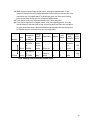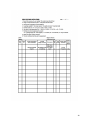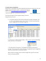
1
Perennial Pepperweed
(Lepidium latifolium)
Control Handbook
For municipalities, nonprofit organizations, and others who will lead the effort to
identify and control pepperweed in their given jurisdiction.
By
Elizabeth Duff and Peter Phippen
Sections by Lou Wagner of Mass Audubon and
Sarah Janson of U.S. Fish and Wildlife Service,
Parker River national Wildlife Refuge
Special thanks to the Massachusetts Bays National Estuary
Program for financial support.
2
Contents
Description of Pepperweed .......................................................................................................................... 1
Prioritizing Pepperweed Treatment ............................................................................................................. 3
Field Mapping Perennial Pepperweed .......................................................................................................... 6
GIS and the Pepperweed Project ................................................................................................................ 17
Permitting for Pepperweed Removal ......................................................................................................... 19
Pulling Pepperweed How-To’s .................................................................................................................... 21
Herbicide Overview..................................................................................................................................... 23
Getting Landowner Permissions: ................................................................................................................ 26
Organizing Landowner Permissions: ........................................................................................................... 27
Coordinating Treatment ............................................................................................................................. 30
Outreach Materials ..................................................................................................................................... 31
Appendix A: Mapping Tools ........................................................................................................................ 33
Using a GARMIN Etrex Global Positioning System (GPS) Unit ............................................................... 34
Foot Mapping Materials Checklist ......................................................................................................... 36
Boat Mapping Materials Checklist ......................................................................................................... 37
Invasive Weed Mapping Form ............................................................................................................... 38
Mapping on Computer Instructions ....................................................................................................... 40
Appendix B: Permits and Landowner Permission Materials ....................................................................... 48
Sample Face to Face Permission Dialogue ............................................................................................. 49
Sample Phone Dialogue ......................................................................................................................... 50
Permission Letter (Conservation Commission Permission Received).................................................... 51
Permission Letter (Conservation Commission Permission Pending) ..................................................... 52
Permission Form .................................................................................................................................... 53
RDA Permitting Form Example............................................................................................................... 54
Appendix C: Pulling Materials ..................................................................................................................... 58
Tips for Pulling Pepperweed .................................................................................................................. 59
Photo Release Form ............................................................................................................................... 60
Appendix D: Outreach and Planning Materials........................................................................................... 61
Perennial Pepperweed and Herbicide—Frequently Asked Questions .................................................. 62
Pepperweed Timetable .......................................................................................................................... 63
Perennial Pepperweed ID Sheet ............................................................................................................ 66
Introduction to the handbook:
Since 2006, Mass Audubon, the U.S Fish and Wildlife Service, the Massachusetts Bays Estuary
Program, and the Newburyport Gulf of Maine Institute team have battled pepperweed in the
Great Marsh Region. This effective partnership has attracted numerous additional
organizations, and hundreds of volunteers each year. While there is much work to be done,
this handbook passes on many lessons learned for battling pepperweed, and/or other invasive
species. We hope that this is of use to others for effectively controlling pepperweed in other
regions in Massachusetts, and preventing its spread to new areas.
John Halloran (Gulf of Maine Institute) with Liz Duff (Massachusetts Audubon Society)
4
Description of Pepperweed
Perennial pepperweed (Lepidium latifolium) is native to Eurasia. In the 1930’s the plant was introduced
to the United States through a shipment of sugar beet seeds. Since that time, pepperweed has become
a serious problem on the west coast infiltrating roadsides, riversides and pasture lands. Pepperweed is
present in all states west of the Rocky Mountains.
Although pepperweed was first recorded in Peabody, Massachusetts in 1924 and Norton, Connecticut in
1933, it has only recently been observed spreading rapidly in Massachusetts and Connecticut. In New
England, infestations of Lepidium latifolium are mainly found near the coast and on coastal islands.
Stands often occur at the upper edges of salt marshes above the high tide line, frequently forming dense
stands. It also occurs along highways, where it grows in disturbed areas near roads. In 2006,
pepperweed was confirmed in New Hampshire.
Pepperweed is classified as a noxious, invasive weed in 15 states, including Massachusetts and
Connecticut. Without the natural checks on its growth which exist for pepperweed in its native habitat,
the plant has been growing and spreading at an alarming pace in the United States. Pepperweed has the
potential to encroach on native plant communities and reduce fish and wildlife habitat. A patch of
pepperweed can grow into a dense, monoculture stand after only a few seasons. These stands are thick
enough to shut out all light to the soil beneath them and dominate water and nutrient supplies which
prevents the growth of native species. Pepperweed stands compete against native salt marsh vegetation
Perennial pepperweed is able to spread both vegetatively by rhizomes and by seed. The root structure
of pepperweed is extensive, penetrating at least 60 cm into the soil. Root fragments as small as 2.5 cm
are able to re-sprout and grow into multi-stemmed plants. Pepperweed is a prolific producer of seeds
which can float though water ways and distribute on the marsh surface. Beginning in June and July,
pepperweed produces white, four petalled flowers which grow in dense clusters (Figure 1). During
winter months, seeds typically drop and pale stems taper to a fine tip (Figure 2).
Figure 1 Perennial pepperweed in bloom
Figure 2 Winter pepperweed
1
Means of Spread, and Spread Rates:
“As an invasive species, pepperweed is of particular concern, because it can spread quite rapidly.
Pepperweed can spread through seed and root fragments, as well as vegetatively. While it can spread
vegetatively only a few meters, its seeds are transported in the tides. Based on our mapping efforts we
have been able to calculate the spread rates. In a typical salt marsh it can spread 200+ meters per year
(Figure 3). This typically occurs along the upland edge of a marsh. In areas adjacent to rapidly flowing
rivers, it has been seen to spread close to a mile per year. In low salinity regions, pepperweed can be
found along creek-banks, as well as along the upland edge. Harvest of salt marsh hay in this region also
creates the potential for human-caused transport for hundreds or thousands of miles.”1
2-3 meters
per year
(Forman Orth,
2005)
200 meters
per year
Vegetative spread from a
patch of pepperweed.
Spread rate of pepperweed
seed along the upper edge
of a salt marsh.
1 mile per
Spread upstream in rapidly
year per year incoming tides in a river.
Tens,
Pepperweed may be
Hundreds and harvested and spread to
thousands of new locations as people
miles
harvest and transport salt
marsh hay .
Table 1 Estimated pepperweed spread rates
Figure 3 200 Meters/Year spread rate in Rowley.
In rapid currents, pepperweed can spread
dramatically. Approximately 1 mile/year
spread rate was noticed along the Merrimack
River. As tidal waters flow upstream in the
Merrimack River, pepperweed has spread
inland with it. Pepperweed was first spotted at
Joppa Flats in Newburyport in 2001. It was
found 3.8 miles upstream four years later.
Figure 4 1 mile/year spread rate
1
Duff, E.B. (2010). Perennial Pepperweed (Lepidium latifolum) Plan of Attack. Wenham, MA.
2
Prioritizing Pepperweed Treatment
If your region is infested with pepperweed, and you are choosing to battle it, you will need to make
choices about which sites you will treat, and what method of control you will use. No matter what
method you use, if pepperweed is growing in a wetland area, you must get permission from the
conservation commission in order to reduce it.
Effectiveness
Issues
Time to treat
1000 square foot
patch of
pepperweed
Spraying Herbicide (.05%
Escort applied with a
backpack sprayer.)
.5 hours
Pulling (and incinerating)
10 hours
Preventing spread Effectively removes
of pepperweed
seeds and plant parts
from the environment.
Also kills roots which
may prevent resprout.
Effectively removes seeds and plant parts from
the environment.
Reducing/
Controlling
pepperweed
“In wetland habitats, repeated pulling of shoots
to remove much of the rhizome was effective
at stabilizing or eradicating whole, well defined
populations. This treatment was most effective
if continued for two or more growing
seasons.”2 One site eradicated by pulling.
Significantly reduces
pepperweed. (95-99%.)
Needs many years of
follow-up work.
Table 2 Effectiveness Issues
Consider your resources, time availability, potential volunteer sources, landowners, etc. when
developing your strategy for treatment. After several years of working to control pepperweed, we have
developed the following strategies:
Strategies
Strategy A:- Work to eradicate pepperweed in areas with few infestations.
Strategy B: Work to prevent spread to pristine areas, and agricultural lands.
Strategy C: Work to control in areas of rapid spread such as along highway corridors, and rivers.
Strategy D, Work to control pepperweed on and near protected conservation lands.
Strategy E: Use herbicide in places that are inaccessible to volunteers, are heavily infested, or are
important to wipe out completely.
2
Forman Orth, J., M. Gammon, F. Abdul Basir, D. Tsirelson, S. Stevenson, S. Speak, R. Kesseli. Natural history,
distribution and management of Lepidium latifolium (Brassicaceae) in New England. Rhodora108: 103-118.
3
Strategy F: Pull pepperweed in patches that are accessible to volunteers, are small enough to effectively
pull, and/or have been designated “pull only” by landowners.
Setting Priorities: If your region is highly infested with pepperweed, you may need to decide which
infestations warrant your attention first. You will also need to decide which areas to treat with
herbicide, which to pull, and which to use both methods. Mapping your region may help you assess the
extent of its spread, and help you set priorities. In the Great Marsh Region, we found large areas of the
marsh free of pepperweed. This helped us focus on preventing the spread to these clear areas,
particularly when one or two patches were adjacent to them. Our neighbors to the north in New
Hampshire had only two or three patches in the whole state. Their funding helped support mapping and
control efforts on the border of Massachusetts, with the intent of preventing its spread north. When
developing a strategy, consider
1. Potential vectors for spread such as:
a. Roadways
b. River Currents
c. Tidal currents (flowing both in and out)
d. Human transport such as collecting mulch from salt marshes.
2. Which infestations are near areas clear of pepperweed, or are the outermost front of
pepperweed spread.
3. To prevent threats to horses and agricultural land keep it out of pasture land. Take a look at
maps to see where agricultural land is adjacent to salt marsh.
4. Consider potential partners in your battle against pepperweed. You may want to prioritize
treatment based on the interests of other conservation groups in your region.
5. Where pepperweed is near fast moving currents, it may spread the fastest. Work to reduce
it in these regions.
6. If you have licensed herbicide applicators working with you, set them on the densest,
biggest patches.
7. Send volunteer pullers to patches where they can see they are making a difference. It is
satisfying to pull a patch completely, particularly when it is adjacent to a clear area. It can
be overwhelming to be pulling pepperweed in a site that goes on endlessly. Be sure you
have landowner permission to pull!
Pulling Strategy:
In Massachusetts volunteers may typically pull pepperweed from late May through the end of June.
This is the season before the plant goes to seed. Volunteers need to pull at safely accessible sites,
preferably where they can see their efforts are making a difference. Pulling may control pepperweed at
low density sites, as well as increase the number of sites treatable by herbicide. Pulled sites should be
rechecked and re-pulled 1-2 times in the months following the initial pulls.
4
Pulling Strategy: (cont’d)
1. Extend the herbicide treatment season by pulling at selected sites and revisiting later in
the season to spray. See Appendix D for a Pepperweed Timetable regarding optimal
spraying time in Massachusetts.
2. Pull in areas easily accessible to volunteers.
3. Pull in areas where proper disposal of materials is possible.3
Mapping Strategy:
1. Boat map or car map unmapped areas particularly those in priority areas.
2. Foot map areas that are infested, and are high priority for treatment.
3. Work to get partners to map regions adjacent to yours.
Planning Tool:
When developing your pepperweed plan, check Appendix D for a Pepperweed Timetable. This
timetable contains information about when pepperweed is likely to bloom, and go to seed in
Massachusetts. It also includes suggested times to complete mapping, pulling, spraying and outreach
activities.
3
Duff, E.B. (2010). Perennial Pepperweed (Lepidium latifolum) Plan of Attack. Wenham, MA.
5
Field Mapping Perennial Pepperweed
a. Introduction/Where to Look:
Perennial Pepperweed typically grows along the upland edge
of salt marshes (Figure 5) and where beach grass grows in
sandy beaches. Its seeds are transported by the tides, but
the plant itself usually does not grow where it is flooded
daily. There are exceptions to this rule, however. In lower
salinity or brackish marshes (0-15 ppt) check for
pepperweed along creekbanks (Figure 6). It can also be
found along creekbanks, in tidally restricted marshes, where
culverts or openings under bridges are too small to allow
normal tidal flow, or where elevation of the creekbanks has
been raised.
Also look for pepperweed in the same places that
marsh elder (Iva frutescens) grows. Pepperweed dies
back, each year, and leaves a standing dead stalk, that
can be recognized even in the winter time (Figure 7).
This allows mapping to occur even in winter months,
when treatment is not possible. You might even want to
get out the cross country skis, and enjoy your mapping
activities on the upland edge of the marsh! Pepperweed
is not confined to salt marshes, it also grows in the
upland, and can travel down roadsides.
Pepperweed
Figure 5 Look for pepperweed along
the upper edge of salt marshes.
Pepperweed
Figure 6 Look for pepperweed along
creekbanks in brackish or tidally
restricted marshes.
Pepperweed
Figure 7 Dead remnants of pepperweed are
visible even in winter months.
6
Pepperweed can easily be distinguished
from marsh elder. Pepperweed has an
alternate branching pattern, while marsh
elder twigs grow in pairs, in “opposite”
formation.
In your initial mapping ventures we suggest you check a map and drive along roads that intersect salt
marshes, and record the pepperweed you find (Figure 8).
Figure 8 Initial map of pepperweed in Ipswich in 2006, done by driving to roads that intersect
with the marsh. (Green is free of pepperweed)
Please note: Recording where you have mapped and found pepperweed free is as important as
recording where you have found it.
b. Mapping Preparation/Materials:
1. Check a tide chart to find out what the tides will be. Plan on boat mapping between 2.5
hours before high tide and 2.5 hours after the high tide to have the best visibility above the
marsh platform, and the most water to travel in. For drier mapping, and better passage,
plan on foot mapping around the hours of a low tide. Mapping from the car can be done at
any tide other than a marsh flooding tide. You can look up tides in your region online at
http://www.boatma.com/tides/.
2. Optional: Take a look on Google Earth to view the area that you plan to map. You can use
the measuring tool to get a sense of how many miles you may go to estimate how long it will
take to walk an area.
3. If possible, line up other people to map with you. If you have more than one car you may be
able to park at the beginning and end, and not have to backtrack. Be sure you bring both
sets of car keys with you!
4. If you are alone, look for sections where you can do a loop and end back where you started.
5. Notice whether or not “No Trespassing” signs are posted, and call the landowner to ask
permission if you see signs.
7
6.
7.
A
B
C
Figure 9 Google Earth can help you plan your mapping trips. The pink line shows a
place that two people may want to do together, parking at point A, and Point B.
Orange line is a loop that one person can easily map alone, parking at point C. The
Google Earth measuring tool shown as a yellow line indicates one stretch of the
journey is .35 miles distance.
6. Prepare Landowner permission letters and forms for your investigation (Appendix B). People
may ask what you are doing as you traipse across the marsh. This is a great opportunity to
educate citizens, and to ask them for permission to treat pepperweed. When you take a break
from mapping, you may find time to talk to landowners. Be ready! See Appendix D for
background materials to provide to the inquisitive landowners. These include a Perennial
Pepperweed ID Sheet, a Laminated ID card, and Herbicide FAQs.
7. Recharge your batteries for the GPS unit, and for your camera.
8. Review how to use your GPS unit. See Appendix A for instructions on Using a GARMIN Etrex
Global Positioning System (GPS) Unit, as an example.
9. Check the weather, you want to map when there is good visibility.
10. For mapping on foot: See Appendix A for packing checklist.
8
c. Information to record: See Appendix A for an “Invasive Weed Mapping Form”
Cover Page: It is important to record the date you are mapping, as well as who is doing the mapping, and
number of hours you are mapping, along with contact information. Often volunteer time is used as match
for pepperweed control funding. Keeping track of the number of volunteers, and time contributed is
important in this regard. Record the region surveyed, and any landowners that you talked to while
mapping.
Data Page: We record “accuracy”. This is read on a Garmin GPS unit before you “mark” your waypoint.
Aim for accuracy to be less than 20 feet. A citizen science website, Citsci.org will not accept accuracy
greater than 50 meters.
1. “Pepperweed Patch ID” is a name you give each site. For simplicity’s sake, do the following
a. Keep the Patch ID short.
b. Make it easier to find the day’s work when downloading your data points by giving that
day’s Patch ID the same unique beginning number or letter.
c. Make sure it is easy to tell which recorded points are marking pepperweed , and which are
indicating that “no pepperweed” is present.
d. End the patch ID with the last two digits year, so it is easy to tell what year it was mapped.
e. Note whether pepperweed is present or not! We use “np” to indicate no pepperweed is
present. “P” indicates pepperweed is present (Table 3).
Accuracy
Patch
ID
Location
Description/ GPS
Coordinates
Parking/
Safety
Concerns
Call for
permission to
park.
Dimensio
ns
Densit
y
How
much?
Comments/
Other
invasives
ID %
Confidenc
e
15
Anp11
1
Lat: 42.789021°
Long:- 70.813398
No
Pepperwe
ed
0
0
0
100%
18
Ap111
Lat: 42.799311°
Long: -70.813398
High traffic
4m x 8m
C
C
Phragmites
present
95%
11
Ap211
Lat: 42.800542
Long: -70.814040
Park at boat
ramp
10m x 20
m
D
E
None
100%
Table 3 Suggested Patch ID: 1st letter A/B/C= mapping day, 2nd letter p/np= pepperweed/no pepperweed,
3rd letter=patch number, 4th =year
2. The arrow above indicates the “No pepperweed” region extends until the first pepperweed point
“Ap111”. The next mapping day, the Patch ID should start with “B”, so points are easier to
distinguish when downloading from the GPS unit.
3. GPS Coordinates: Set your GPS to record in “Decimal Degrees”.
To do this, turn on your GPS Unit. On the Garmin eTrex Legend® and eTrex Vista®, the on button
is the lower one on the right side of the unit. Click on the top button on the right side until you
9
4.
5.
6.
7.
see the menu screen. Click on “Setup” and then on “Units”. In the area that says “Position
Format” click on “hddd.dddd”. The decimal degree format is the easiest to record, and to type. It
is also the format used by the citizen science website “CitSci.org”
Parking/Safety Concerns: Is parking available? How many spaces? Any safety concerns? (Poison
Ivy, Barking dogs) Describe briefly. Consider whether it would be possible to bring a group here
to pull pepperweed, or preferable to send someone to administer herbicide.
Dimensions: Estimate the patch size (length and width, diameter). Ideally use meters in your
estimate. Record this in the box.
Density: How dense is the pepperweed within the patch? Use this scale: A = <25%, B = 25-50%, C
= 50-75% or D = 75-100%
How Much pepperweed is present? Use this scale: A = a garbage-bagful, B = a few bagfuls, C = a
truckload, D = 2-3 truckloads, E = many truckloads
8. Comments/Other Invasives: Record any comments in this box. Oftentimes you will find
pepperweed growing in the spaces between Phragmites australis, another invasive species which
grows along the upland edge of salt marshes (Figure 10). Look closely, Pepperweed can also grow
within a Phragmites patch. As many people are working on Phragmites control in Massachusetts,
it is important to alert land managers to the potential issue of increased pepperweed spread due
to Phragmites control.
9. ID % Confidence: You may or may not be 100% sure of your identification, especially if you are
mapping from a distance. Record percent confidence that the patch is (or isn’t) pepperweed.
10
Phragmites
Phragmites
Pepperweed
Pepperweed
Figure 10 Pepperweed often grows in the spaces between Phragmites australis patches.
Control of Phragmites may open room for pepperweed to spread.
11
d. Mapping Procedure:
1. Scan or walk along the upland edge of the marsh, looking for pepperweed. If you started at a point
where no pepperweed was found, you can indicate later on a map there was “no pepperweed” by
drawing a green line from your starting point to the place where you first encounter pepperweed.
2. If you find a small patch of pepperweed mark it with one point.
3. If you find a large patch of pepper weed, mark the beginning point, fill in the rest of the data, and
then walk to the end of the patch and mark the end point. On your data sheet draw a double
headed arrow between the two data points to indicate they are connected and are one large patch
(Table 4).
Accuracy
Patch
ID
Location/GPS
Coordinates
Parking/Safety
Concerns
cP11
1
N 42.68736°
W: -70.8009
Island –Hard
to access
50 m x 1m
B
cP21
1
N 42.68763
W -70.79994
Ditto
Same as
above
B
19 feet
15 feet
Dimensions
Density
How
Much?
Comments/
Other
invasives
ID %
Confidence
D
Need
permissio
n to
access
100%
D
None
100%
Table 4 Mapping form with double headed arrow
4. When you return from the field, download your data points to a digital map. See Appendix A
“Mapping on Computer Instructions” for details for downloading points from Garmin eTrex Legend®
GPS units, and using Google Earth to communicate your findings. Be sure to compare your data
sheet to your downloaded points to make sure all data has been transferred.
e. Methods of Mapping:
1. By Car: Using a map, find the areas in a town where roads cross or are adjacent to salt marsh. Drive
to these places looking for pepperweed. Slow down, or stop in areas where you see marsh elder. This
plant grows in the same conditions that pepperweed is found. Bring binoculars, GPS unit, Data Sheet,
and a map to record what you find. Scan along the upland edge of a marsh. Remember, safety first
when on the road!
12
2. On Foot: Mapping on foot is time consuming, but can be done year-round. Learn to look for
pepperweed in all of its stages and forms: tall dead stalks, short rosettes, individual stems, gone to seed,
etc. Look for pepperweed along the upland edges of marshes. You may want to start in areas where
you have previously mapped by boat, or car, to see how far an infestation goes. Be sure to record
where you travelled that was pepperweed free, as well as areas that are infested.
Figure 11 Learn to recognize pepperweed in all of its forms.
13
3. Boat mapping: Boat mapping allows you to cover a lot of ground in a short amount of time. Make
sure there is more than one person available to go with you. One person will steer the boat, the
other(s) will look for and record pepperweed. Be sure to check the tides. You can only go so far up
narrow creeks. Strategize your mapping time based on what creeks you want to access at the highest
point of the tide. Be sure to bring binoculars! With binoculars, you should be able to view a couple
hundred meters from the boat. We often start boat mapping in late July and continue into early
September when the pepperweed has mostly gone to seed. It is typically growing about waist high at
this time. We have found that some harbormasters are willing to donate their boats and their time to
help with mapping efforts. Don’t forget to include the value of the boat and captain, when you are
documenting match.
Suggestion: Before mapping in a boat, revisit a site known to be infested with pepperweed. Take a
look at the pepperweed from a distance of a couple hundred meters, using your binoculars, to train your
team’s eyes to the search image you are looking for. If possible, view pepperweed in different stages:
in blossom, and gone to seed, since you will be looking for it in all of its forms and colors.
Scan along the upland edge of the salt marsh or shoreline looking for pepperweed. If you are in a
brackish or freshwater system, also scan along the creek banks.
4. Kayak or Canoe Mapping: Kayaking or canoeing may allow you to access points that are inaccessible
via powerboat. On high spring tides, you may be able to actually go across a salt marsh, and not be
confined to the creeks. In areas with lots of docks and marinas, you may be able to fit underneath ramps
to the floats, and view the shoreline in places a boat could not access. Some kayak rental groups may
donate their kayaks and this may be used for match in grants.
To ensure better accuracy: Bring a map of the area you are covering, and a red pen. When you map
points from a boat that you have discovered through binocular viewing, you may be hundreds of meters
away from the waypoint you are recording on the GPS. Draw on the map the spot you are recording.
When you download these data points from your GPS unit, they will probably show up in the middle of
the water. Remember to edit these points by dragging them to the shore where you saw them, and
note the new coordinates. Record this more accurate waypoint on a new data sheet.
Pay attention to:
Note the area that you covered when mapping.
Note what areas you cannot see from a boat, and will need to go back on foot.
If you think something is pepperweed, but are not sure, you may want to land and get out of the
boat to check it out, or revisit the area at a later date on foot.
Note where “No Trespassing” signs are posted. You will need to get permission to walk these
areas on foot.
If you think you see pepperweed, ask your partner(s) in the boat to confirm the spot you are
viewing. More eyes will lead to better accuracy.
14
Figure 12 Is that brown stuff pepperweed? Take a look in your binoculars. You might want to
go ashore to find out. This spot in Gloucester was confirmed in the summer of 2010.
15
Mapping Pepperweed Dos and Don’ts
Please remember that much of our region’s salt marshes are private property.
Don’ts
1. When mapping pepperweed, make sure that you are not walking onto land marked “no
trespassing” unless you have permission from the owner, or caretaker of the land.
DO’s
1. It is better that you are mapping with a partner, to ensure your safety in the marsh.
2. If possible, bring a cell phone, GPS unit, and camera.
3. Wear your name tag and uniform that identifies you as a ___________ (your organization)
representative. If you are working with other volunteers, encourage them to dress in a way that
encourages trust. Perennial Pepperweed t-shirts might be an option.
4. Carry the pepperweed ID card, to show interested citizens who ask you about your work. If they
have time, and interest, show them how to recognize the pepperweed.
5. Carry pepperweed permission-to-treat forms (Appendix B) with you. You may find that you
have the time to talk to property owners and to ask for permission to treat.
6. If you are asked to leave the property, do so immediately, without question.
7. Look for pepperweed in the regions where you see marsh elder. This is primarily the upland
edge of the marsh. It may also be along ditches, and raised areas of the marsh.
8. Minimize your impact on the marsh. If possible, with a partner, park on both ends of a marsh
section so you only need to walk one way in the marsh.
16
GIS and the Pepperweed Project
A Geographic Information System (GIS) is a computer system that captures, stores, analyzes, manages,
and presents data that are linked to location.4 For a pepperweed control project, GIS can help to record
and locate pepperweed stands, keep track of treatment and plant response and organize landowner
permission and status. It is also a tool to share pepperweed locations, treatment types and generally
communicate project information with partners, funders, regulators and anyone interested in the
project. This chapter is written to give a few tips to a GIS user for organizing incoming pepperweed data
and landowner information. Please find an experienced GIS user to develop your data and maps.
Data Management with GIS
Pepperweed stand location information can come into your office in many ways: latitude and longitude
coordinates, hand-drawn location on maps or aerial photographs, KML files exported from Google Earth,
shapefiles sent from other GIS users, or verbal descriptions from on-the-ground mappers. However you
receive the locations is very useful to keep all the data in one place—like a GIS shapefile or Geo
database. Helpful information to keep track of in the Attributes Table along with actual stand location
includes:
Point Identification Code
Approximate stand size (m2)
Town where stand is found
Nearest road or other general location identification
Person(s) doing the mapping
Year mapped
Treatment (for each year)
Other comments, site considerations
The Office of Geographical Information: MassGIS webpage (http://www.mass.gov/mgis/) is a great
source of base layer information including topographical maps, aerial imagery, landowner and parcel
information, and town boundaries. This information is available for free and can usually be downloaded
directly from their website.
The Assessors’ Parcels layer available from the MassGIS webpage is very useful for managing
information about landowner permissions. This layer is available for many, but not all, towns in
Massachusetts. By adding your Pepperweed locations layer to the Assessors’ Parcel layer, you can
generate a list of which landowners you need to contact for permission. By adding additional columns
to the Assessors’ Parcel Attributes Table, you can track landowner response to your request for
permission to treat.
4
http://en.wikipedia.org/wiki/Geographic_information_system. Accessed Feb. 22, 2011.
17
Integrating Google Earth and GIS data
A very useful tool is the “Export/Import Data to/from KML” tool available through XTools Pro. Similar
tools may be available from other sources. This tool enables you to share data with users of Google
Earth. Google Earth is a free program which is available on the web (www.google.com/earth). Since not
all offices and people involved in pepperweed mapping and control have access to GIS programs and
tools, sharing information back and forth through Google Earth and a GIS system helps work through
this hurdle.
18
Permitting for Pepperweed Removal
Under the Massachusetts Wetland Protection Act (WPA), the Commonwealth of Massachusetts
regulates all impacts to wetlands. If your pepperweed control project is within a wetland, you must talk
to the Conservation Agent in the town to find out how to proceed. Wetlands include ponds, streams,
salt marshes, coastal banks, tidal zones and many other habitats. Impacts which are regulated include
paving, planting, building and vegetation clearing. Since pepperweed control involves removing
vegetation usually from a wetland habitat, the WPA and its regulation apply. The Commonwealth
delegates permitting authority to each town and its Conservation Commissions. Towns also have their
own bylaws to protect wetland resources. Hopefully this chapter will help you get started in the
permitting process for a pepperweed removal project.
The best first step in this process is to talk to the town’s Conservation Agent. This person can usually be
identified through the town’s website or a call to the town offices. Explain the project, goals and
methods to the Agent for his or her recommendation on navigating the permitting process in that town.
Size, scope, location and methods (i.e. mechanical versus chemical control) will factor into the
permitting path the Agent deems appropriate.
Often you will submit a Request for Determination of Applicability (RDA) to the Commission. This
document asks the Commission to determine that the rules of the WPA do not apply to the control of
pepperweed or other invasive species. The rationale is that removing invasive plants will improve and
restore the wetland habitat and function. Also the work will be gentle on the habitat and not harm
landscape features. The RDA requires filling out MA DEP WPA Form 1 and submitting maps of the area
affected, landowner permission and any other supplemental information you think is important to
describe your project. Some towns require notification of abutters within one hundred feet of the
property boundary line, other towns do not. If necessary the Assessor’s Office in town can generate an
official list of abutters for your project. You will be asked to present your request at a Conservation
Commission public hearing and hopefully a determination can be made at that time. The Commission
may issue a continuance if more information is required. Usually an RDA will allow three years of work
on a site. It can often be renewed with another request to the Commission. See Appendix B for a
completed “RDA Permitting Form Example”.
An alternative to the RDA is a Notice of Intent (NOI). The Commission may feel that this higher level of
permitting applies to the project. You must fill out MA DEP WPA Form 3 for an NOI. In addition to the
requirements for an RDA, the NOI will require identification and notification of abutters to the
properties where work will occur. It also requires an Order of Condition, with a $75 fee, be attached to
the landowner’s deed. This assures that the work will be completed and environmental safeguards will
be met. NOIs usually permit the work to be completed within 10 years.
Whether you submit an RDA or NOI, it is a good idea to notify landowners in advance of the public
hearing so they can be involved in the process, ask questions, and show their support for the project.
19
In several towns on the North Shore, we have been able to get Town-wide or Area-wide permission from
the Conservation Commission. For this type of permission, we are able to designate an area where
pepperweed may grow and get permission from the Commission to treat pepperweed where and when
we find it. Treatment is pending permission from the landowner and either notification to the Agent
before treatment or a report at the end of the year. See Appendix B for materials such as sample
dialogues, cover letters, and permission form for gaining landowner permissions. This type of
permitting is very helpful for controlling invasive species because it can be difficult to inventory an entire
town before treatment season begins or the plant can spread quickly.
“My personal experience with Conservation Agents and Commissions has been very good and
fruitful. In 5 of the 6 towns I approached, I obtained RDAs for mechanical and chemical
pepperweed control. In the sixth town, the Commission granted written permission for the
work without formal application paperwork. The Commissions have been supportive and
welcoming of the concept of combating invasives in their jurisdiction. As each town is unique
and independent, do discuss your plans with the Agent to develop a roadmap for your permit.”5
5
Janson, S. (2011) Interview.
20
Pulling Pepperweed How-To’s
a. Introduction: Pulling pepperweed is a great feel good activity that is perfectly timed with the
end of the school year. Students have finished their MCAS testing, and are aching to be outside.
Teachers are looking for a hands-on project that will keep their students busy. Many schools
are involved in pulling pepperweed, and have made it an annual June event. Follow up pulls
may be done by summer campers, interns, or by citizen volunteers. Some local businesses help
coordinate community service for their staff.
b. Preparing to pull pepperweed.
1. Make sure you have the landowner’s permission to pull pepperweed. This is especially
true for places where you are bringing a group of volunteers. If you have a large group, be
sure to do advance scouting and preparation, to ensure you have plenty of pepperweed for
the group to pull during their allotted time.
2. Make sure you have enough 3 mil contractor grade garbage bags for all the pepperweed you
are pulling (Figure 13). Flimsy bags can create new pepperweed infestations. Do not make
the pepperweed problem expand due to poor planning.
3. Make sure you know where the pepperweed you are pulling will be disposed of. Check with
town officials, or schools conservation groups in the town to find out if you can use their
dumpster. Make sure that the materials put in a dumpster will be incinerated.
4. Make sure you have a way of transporting bags of pepperweed to its disposal site.
5. Do NOT put pepperweed materials in a compost. Stems and roots may easily resprout. You
can do more harm than good this way.
6. Plan to re-pull sites you are pulling: Set a schedule to revisit each pull site 1-2x a month for
the next couple of months to repull anything that your group has missed.
7. If you are working with minors such as a school group, check to see whether participants
have photo release forms signed for their school trips. Remind teachers to bring first aid
kits, cell phone, and any medicine (inhalers, or epipens) their students may need.
c. Document before and after Conditions: Choose some easy to replicate locations to take photo
shots from before and after pulling. Set up wooden stakes or use other recognizable
landmarks. Document these locations, with a GPS unit. Return to these sites monthly.
d. Demonstrating effective pulling techniques. Make sure you demonstrate to your volunteers
how to recognize pepperweed, including rosettes, and how to distinguish it from other plants.
Review the “tips for pulling pepperweed” with your group. Show them how to pull slowly from
the base to get as much root out as possible (Figure 12). Ask for certain volunteers to be the
“clean-up crew” adept at recognizing even the rosettes, and willing to pull them out.
e. Ensuring proper bagging and disposal: Volunteers will follow your lead, so make sure you
demonstrate- do not overfill the bags. Make sure bags are double knotted at the top so nothing
escapes (Figure 14). Double bag if you see stems have poked holes in your bags. Make sure all
bags are removed from the site and disposed of properly.
f. Tips for Pulling Pepperweed: Share the “Tips for Pulling Pepperweed” (Appendix C) flier with
your volunteers.
g. Sample Photo Release form: Have adult volunteers sign the “Photo Release Form” (Appendix C)
21
Figure 12 Pull as much root as possible
Figure 13 Use 3 mil contractor grade garbage
bags.
Figure 14 Make sure there is no way for
pepperweed to escape from the bags. Double
bag if stems poke through the first bag.
22
Herbicide Overview
Introduction
Herbicides are a class of pesticides used to kill plants. They are an effective tool for the control of
perennial pepperweed. However, care must be taken to ensure that the proper herbicides are used and
that they are used in a safe and effective manner. When not used properly, herbicides may cause
environmental harm and pose a health and safety threat to the person applying the herbicides and the
general public. Herbicides are regulated at the federal and state level, and may be regulated by
municipalities. In Massachusetts, you must be licensed as a pesticide applicator in order to apply
pesticides on land you do not own. Licensing requires passing an exam and demonstrating proof of
liability insurance. Licensed pesticide applicators are required to report all pesticide use each year to
the Massachusetts Department of Agricultural Resources and must renew their applicators license
annually. Full information on licensing and Massachusetts pesticide laws and regulations can be found
at the Massachusetts Department of Food and Agriculture website at:
http://www.mass.gov/agr/pesticides/index.htm
In Massachusetts, the application of herbicides in or near wetlands requires review and approval by the
municipal conservation commission under the Massachusetts Wetlands Protection Act. Review by the
Massachusetts Department of Environmental Protection may also be necessary. Anyone proposing the
use of herbicides in or near wetlands should contact their local conservation commission to determine
permitting requirements. Permitting requirements may vary depending on the size and scope of the
proposed project. Pesticide applications in areas where rare, threatened, or endangered species are
known or believed to be present will require review by the Massachusetts Natural Heritage and
Endangered Species Program.
Not all herbicides are licensed for use in wetlands. To be used in wetlands, herbicides must be
registered for aquatic use by the U. S. Environmental Protection Agency and the Massachusetts
Pesticide Bureau. Every herbicide formulation has a label approved by the U. S. Environmental
Protection Agency. The label identifies mandatory safety precautions, including necessary personal
protective equipment to be worn by the herbicide applicator when making the application, and
restrictions on public entry into the area where the herbicide has been applied. The label also specifies
the manners in which the herbicide may be applied and the amount of herbicide to be used in treating
various species or classes of plants.
Active Ingredients
Active ingredients are the portion of a herbicide that kills plants. The concentration of active ingredient
in commercially available herbicide formulations can vary greatly, from less than 1% to more than 50%.
Herbicides with very low concentrations of active ingredient are often ready to use direct from the
container without dilution. Herbicides with higher concentrations of active ingredients typically require
dilution when applied as a spray or mist. The herbicide label will provide specific instructions for each
herbicide product.
23
Herbicides with the following active ingredients have been found to be effective against perennial
pepperweed:
Active Ingredient
Glyphosate
Name Brand
Rodeo
Aquamaster
Metsulfuronmethyl
Escort
Impact
Aquatic use?
Broad Spectrum (kills
most plants)
Yes
Kills broad leaved
plants.
Not approved for aquatic use.
Should not be used below
mean high tide.
Table 1 Suggested Herbicide for Pepperweed Control
Herbicide Needs
Applicator License and insurance.
Equipment necessary & costs for mixing and applying an herbicide like Escort:
Chemical Gloves--about $2.50/pair (high quality elbow length nitrile gloves are $7.45 each at
Forestry Suppliers)
Goggle/Eye Protection-$5.00/pair
Scale--$50.00 (like Ohaus Pocket Scale from Forestry Suppliers--to measure out 0.33 oz Escort
powder to mix with 10 gallons of water)
Graduated cylinder--about $15
35 gallon Barrel --$75 (for mixing and transporting herbicide mix)
Hand Pump, $11.95 for "Plastic Syphon Pump" from Forestry Suppliers
Backpack sprayer--$700 (perhaps the Solo model 433 Motorized Backpack Sprayer) Hand
operated backpack sprayers can be purchased for between $80 and $200. The more expensive
ones are recommended if frequent use is expected as they are more durable and reliable.
Escort-- $200/16 oz. (One bottle lasted us years) This herbicide is for use above the mean high
tide line.
Induce surfactant--$36/gallon (also lasts a long time)
Total Equipment Cost: about $865
Total Chemical Cost: $236
Personal gear while spraying:
Long sleeved shirts, long pants, hat, boots/sturdy shoes
24
Documentation, Record Keeping, and Signage
Some form of monitoring or documenting the effectiveness of herbicide treatments is needed to assess
the success of pepperweed control projects. Monitoring and documentation can range from relatively
simple protocols, such as digital camera images of the pepperweed stand before and after treatment, to
more intensive monitoring involving the establishment of monitoring plots and the recording of detailed
information on the species present within the plots, the percent cover of each species or class of
species, and the relative vigor of various species within the plots. For most perennial pepperweed
control, digital images taken before the herbicide treatment and the following growing season, along
with an estimate of the size of the pepperweed stand will be sufficient.
Several records of pepperweed control efforts should be maintained. These should include records of
work performed, the date of project control activities, and detailed information on herbicide
applications, including the name of the product applied, the EPA registration number and the amount of
the herbicide used, the method and date of application, and weather conditions at the time of
application.
Signage may be needed to warn the public to avoid areas where herbicides have recently been applied.
The pesticide label includes information on how long entry to an area treated with herbicides should be
avoided. There are specific requirements for signage and notification when pesticide applications are
made in certain areas, such as schools and child care centers. Herbicide applicators should consult the
Massachusetts pesticide regulations, which can be viewed at
http://www.mass.gov/agr/pesticides/index.htm.
Timing
There is a small seasonal window of opportunity for treating pepperweed. Herbicide is most effective
when the plants are in bloom. It is important to treat before plants have gone to seed. In
Massachusetts this is typically late June-early July. This timing varies from year to year, and also from
site to site. Well-drained sites seem to blossom and go to seed earlier than more flooded ones. Check
herbicide labels regarding the window of time to leave before and after rain events. This is typically at
least 4-6 hours. Spray when leaves are dry. Wait until dew has dried, and avoid spraying if
thunderstorms are predicted. Reentry to the site for people and animals is listed on the label. For
Escort it is 4 hours.
25
Getting Landowner Permissions:
You will need landowner permission to treat pepperweed. If possible, map pepperweed in late summer,
fall, winter and spring and begin working to get landowner permission before the treatment season in
June and July. If a property is marked with “no trespassing” signs, be sure to get landowner permission
first to map the area. We have found that in the Great Marsh Region, citizens are generally aware
about the problem of invasive species, and are grateful that we are working to solve the problem.
Most conservation commissions we have worked with ask for signed permission letters. We have been
successful in some towns in getting blanket permission to treat pepperweed from the conservation
commission. This is the most efficient way of staying ahead of a rapidly spreading invasive species.
Knowing that pepperweed can spread 200 meters or more along the upland edge of a salt marsh in just
one season, It is a good idea to ask permission, not only for the areas currently infested with
pepperweed, but also neighboring properties. We have done mailings, phone calling, and face to face
discussions to obtain permission. There are advantages and disadvantages to each of these. Assess
your priorities, and time availability to help you decide how to proceed. A combination phone call with
letter or email follow-up may be most time effective. Note whether property owners own more than
one parcel. You may be able to cover a lot of ground with a few targeted landowners. See Appendix B
for sample dialogues with landowners, permission letters, and permission slips. You may want to print
and carry copies of informational materials to help you answer landowner’s questions. See Appendix C
for additional outreach material such as the Perennial Pepperweed Identification Sheet, the Herbicide
FAQs, and an example of a pepperweed Laminated ID card.
26
Organizing Landowner Permissions:
a. Introduction: Once you have mapped pepperweed, you need to find out who owns the property
it is growing on, in order to get permission to treat it. Although you can go door to door
knocking, you may want to make phone calls, or send letters, in order to reach more people at
once. In many cities you can find out property owners on line.
b. Locating Landowners:
1. Accessing Parcel maps. Many towns have parcel maps and landowner information on line.
Go on line and search for “Assessors Maps” and indicate the town you are searching for.
2. Click on “Tax Maps”. You may need to click on an “index map” to see all the regions of the
town.
3. Click on a region of the town that you know is infested with pepperweed. You may need to
“unblock” to allow the tax map to download.
4. Print the map.
5. On your computer, zoom in to read the map. It is likely that the tax map you are looking at is
shown “zoomed in” and the parcel numbers are too small to read. Zoom in closer to read
the parcel numbers.
6. In pencil, record parcel numbers on your printed map.
7. Look up parcels on line.
1. Click on property assessments.
2. Type in the parcel number. (You can also look up landowners name if you type in
the address.)
3. Record name and address of the landowner on your printed map.
8. Transfer this information to your electronic map.
a. Copy the map into PowerPoint: Click on “Print screen” on your computer, and open
up PowerPoint and click on “Paste”. Click on “Picture Tools” and crop your photo.
b. Click on “Insert” Text Box and type in large font the parcel number on top of the
image in PowerPoint. In large font (18 or more) record parcel number, landowner,
and address.
c. To keep these labels together with the image click on each label, (hold down the
control button to click on more) and click on the map image then click on picture
tools and click on “group”
d. Color code your map- drawing on where pepperweed infestations have been
mapped. Yellow is pepperweed. Green= clear of pepperweed.
9. Look up landowner phone numbers. You may be able to do this on line. To try it out, go to
http://www.whitepages.com/ and type in the name and town of the person you are looking
up. Keep track of landowner phone numbers in an excel file. If you have space, record the
phone number on your map(s).
c. Keeping Track of Landowner Permissions:
1. Create an excel file to keep track of all of this information. (sample format below)
27
2. Update your excel file and maps as permissions come in. Suggested color code: Green = ok to
pull and use herbicide, Orange = Pull Only. Red = Do not treat.
3. Assess your progress: Use the maps and excel files to assess what additional permissions you
need, and what areas you are cleared for treatment. Share this information with your
teammates and strategize your plan for attack.
Color
Code
Responses
Region
(Assign if
multiple
regions in
town)
JNR
Blue is
need
to take
action
on
Green is
yes for all
Owner
Owner's
Mailing
Address
Joe
Smith
P.O. Box
00
Ipswich,
MA 01938
Yellow
=verbal
yes,
need
written
Owner'
s Town
Ipswich
Orange
= pull
only
Red
=no
Phone #
E
mail
9785551212
Site
ID
15C_
060
Site
Address
1 Pond
St
Pepp
erweed
?
Yes
Permission
Yes
Permission
Date
Comments
3/15/2008
Call before
coming.
They want
to put dogs
inside.
Table 2
Things to include:
Parcel Maps: If you have access to GIS, you may be able to get parcel maps for some towns. This can
help sort out whose property pepperweed is growing on. You can click on each parcel, and find out the
parcel number, and street address. With this information you can look up the owners name on line.
Suggestion: Get permission from property owners between infestations, and at least 200 meters
upstream and downstream of current infestations. Pepperweed spreads rapidly. It is better to get
advance permission, and not need it, than need permission and not have it. We have seen pepperweed
spread up to a mile in a year in rapidly flowing currents. In places like this- particularly adjacent to clear
areas- you may want a much wider window of permission.
Electronic Layers can help you figure out where pepperweed is, and who owns the land.
Figure 15 Google Earth with yellow
thumbtacks showing pepperweed and green
polygon of “clear” area.
28
Figure 16 GIS parcel maps overlaid with
mapped pepperweed
Figure 18 combines parcels with an aerial view.
The numbers were added in PowerPoint and
color-coding done with “WordArt”. Next priority
would be to contact the property owners at 439
Main Street to ask for permission, and to
contact all the other “blue” households to ask
permission, in case pepperweed has spread
since last year.
Figure 17 Click on a parcel to find out
parcel number and address.
Figure 18 Color code to communicate permission status.
29
Coordinating Treatment
If you have multiple people treating pepperweed mechanically or chemically, be sure to coordinate your
efforts. It can be disenheartening to drive an hour to treat a site only to find it was pulled the week
before. In the days immediately following an herbicide application one cannot tell whether or not a site
has previously been sprayed. We suggest:
1. Group individual sites into “regions”.
2. Assign regions to individuals or groups who will be responsible for treating them.
3. Utilize mapping tools such as Google Maps, and Google Earth to communicate about sites that
have been treated.
4. Keep track of your time spent, and volunteer time spent, travel time, chemicals used, etc. to use
as match.
5. Report into a coordinator who keeps track of regions treated.
6. Put flags and signs in areas that you have treated, to raise awareness.
30
Outreach Materials
In the Great Marsh Region, We have developed a number
of materials designed to educate citizens about
pepperweed. This includes a Perennial Pepperweed ID
Sheet, Laminated ID cards (Figure 18), and roadside signs.
Each of these tools is useful for raising awareness about
invasive species, and helping to identify pepperweed. See
Appendix D for more information about these materials.
Figure 18 Laminated ID cards are useful
tools for educating local citizens.
Roadside Signs
To help raise awareness, we designed a coroplast sign to inform local citizens about our control efforts.
Some people collect old dead washed up grasses from the wrackline salt marshes to use as mulch in
their gardens. This has the potential of spreading pepperweed seeds to new locations, if the site is
infested with pepperweed. Suggestion: Post signs adjacent to where you are pulling or spraying
pepperweed. This not only helps raise awareness about the project, but supports an informed local
citizenry (Figure 19). We have found most landowners quick to give permission to treat pepperweed in
towns where we have posted these signs. Coroplast Signs can be designed on line at:
http://www.dynamic7.com/ .
Figure 19 Roadside signs help raise awareness.
31
32
Appendix A: Mapping Tools
Using a GARMIN Etrex Global Positioning System (GPS) Unit. ............................................................... 34
Foot Mapping Materials Checklist ......................................................................................................... 36
Boat Mapping Materials Checklist ......................................................................................................... 37
Invasive Weed Mapping Form ................................................................................................................ 38
Mapping on Computer Instructions........................................................................................................ 40
33
Using a GARMIN Etrex Global Positioning System (GPS) Unit
Refer to your user manual if you have a different type of GPS unit.
2. Turn the unit on using the lower button on the right side of the GPS Unit.
3. When first turning on your GPS unit, stand outside where you can see the sky.
This will help your GPS unit acquire satellites. The more satellites it acquires,
the more accurate it will be.
4. Click on the top button on the right side until you can see a menu page that
includes “Satellite”.
5. The button on the front of the GPS unit acts like a joy stick. Click on “Satellite”
and you will read at the top “Location” _#_ft. That number represents how
accurate the GPS unit is reading. The more satellites you acquire, the lower this
number will be. Ideally, your number will be lower than 20 feet.
6. To the right of this, you will see the coordinates for your position. If it is
reading in decimal degrees your number will be in this formation:
N42.67639°
W070.81796°
If your GPS unit is not reading in that formation, known as “decimal degrees”,
toggle back to the menu screen and click on “Setup” and then click on “Units”
and where it says “Position Format” make sure it reads hddd.dddd°. If your GPS
unit is more accurate than a Garmin, there may be more decimal points. That is
fine!
Decimal degrees is the easiest format to write down, and type in. It is also the
format that the Citizen Science Website CitSci.org uses.
7. On your data sheet record “Accuracy” and the number of feet shown on your
GPS unit.
8. Record your coordinates.
9. Toggle back to the screen with a menu, and use the joy stick button (on the
front) to go to and click on “Mark”
10. Toggle to the top of the screen (Your curser will be at the bottom, so the
easiest way to do this is to go down with one click, which actually takes you to
the top immediately.) Click and you will get letters and numbers, This is where
you type in a code for the site you are recording.
11. If you are just starting out (in the year 2011) and there is no pepperweed
present, record ANP111. A is the letter you will use on your first day mapping.
NP stands for No pepperweed. 1 is the first no pepperweed found. “11”
represents the year 2011. When you start typing letters, the numbers
disappear, to get them back click on the upward facing arrow just above the
letters x and y.
12. Once you have typed in your code, click on “ok”.
13. To save your waypoint: Toggle down and click on “ok” once more or your
point will not be saved.
34
14. Walk along the upland edge of the marsh, looking for pepperweed. If you
started at a point where no pepperweed was found, you can indicate later on a
map there was “no pepperweed” by drawing a green line from your starting
point to the place where you first encounter pepperweed.
15. If you find a small patch of pepperweed mark it with one point.
16. If you find a large patch of pepper weed, mark the beginning point, fill in the
rest of the data, and then walk to the end of the patch and mark the end point.
On your data sheet draw a double headed arrow between the two data points
to indicate they are connected and are one large patch.
Accuracy
19 feet
Patch
ID
Location
Description/
GPS
Coordinates
N
42.68736°
W: cP111 70.8009
Parking/
Safety
Concerns
Islandhard to
access.
Dimensions
50m x 1m
Density
B
N 42.68763
WSame as
15 feet cP211 70.79994
ditto
above
B
Fig. 8 Mapping form with double headed arrow.
How
much?
D
D
Comments/
Other
invasives
ID %
Confidence
Need
permissio
n to
access
100
%
None
100
%
35
Foot Mapping Materials Checklist
Filled water bottles (More than one!)
Sunscreen
Insect Repellent
Pencils/pens
Pepperweed ID cards to share (Appendix D)
Landowner Permission forms and letters (Appendix B)
Pepperweed mapping forms
Camera (with recharged batteries)
GPS Unit (with recharged batteries)
Binoculars
Clip board
Hat
Waterproof boots
Extra layers of clothes, depending on weather. We suggest long pants and sleeves
due to insects.
Snack/lunch
First Aid Kit
Extra batteries
Sunglasses
Invasive Weed Mapping Forms (Appendix A)
36
Boat Mapping Materials Checklist
Recharge your batteries for the GPS
unit, and for your camera.
Make sure you have enough fuel for
your trip.
Map of the area you are mapping.
Red pen for marking on map.
Sunglasses
Water bottles (More than one!)
Sunscreen
Insect repellent
Pencils/pens for data sheet.
Pepperweed ID cards
Landowner Permission Letters
(Appendix B)
Personal flotation device
Standard boat safety gear
Invasive Weed Mapping Forms
(Appendix A)
Clipboard
GPS Unit (with charged batteries)
Camera (with charged batteries) and
case
Binoculars (one for each participant)
Hat with a brim
Water sandals or shoes
Extra layers of clothes, (wind breaker,
sweatshirt)
Long pants and sleeves due to insects.
Snack/lunch
Cell phone
Extra batteries
37
Invasive Weed Mapping Form
38
39
Mapping on Computer Instructions
(EXAMPLE – your equipment may differ)
Introduction:
Once you have collected data points in the field, transferring them to a map will help
communication and planning. If you are using a Garmin GPS unit, the following instructions
will assist you in downloading your points, and transferring them onto an electronic map. The
programs involved are fairly user friendly, and are free. They include DNR Garmin, and Google
Earth. These instructions will explain the following procedures needed to use Google Earth to
map data gathered on GPS units and by hand.
Instructions include how to:
1. Download points (from Garmin GPS units) using the DNR Garmin program.
2. Transfer points to Google Earth
3. Edit the appearance of your points and create paths and areas
4. Organize, share and save your work.
1. Downloading Points onto your computer:
The fastest way to transfer points from a GPS unit to your computer is to download them.
Current models of GPS units work with USB cables but need another program to allow the
transfer of information.
DNR Garmin is a free program that allows you to transfer information in a Garmin GPS unit to
various Geographic Information System (GIS) packages, as well as to “Google Earth”, a free,
easy to share web-based mapping program.
Steps:
a. If you do not have the “DNR Garmin” program on your computer already, go to:
http://www.dnr.state.mn.us/mis/gis/tools/arcview/extensions/DNRGarmin/DNRGarmin
.html and scroll down until you see “Download Program”. Read through the various
versions. You may want to choose the most recent version to download, but check to
see if it is compatible with programs already loaded onto your computer. Follow the
instructions to download, and install this program. This will allow you to transfer from
Garmin GPS handheld receivers and various GIS software packages as well as with
Google Earth.
b. Turn your GPS unit on. (Make sure batteries are charged so it will go on!)
c. Connect the USB cord from your GPS unit to your computer.
40
d. Start DNR Garmin program by clicking on the icon (Figure 1).
DNR Garmin icon
This appears.
Figure 1 DNR Garmin Program
e. Click on “Waypoint” and as a dropdown menu appears, click on “Download.”
f. All of the waypoints on your GPS will appear, and you need to look for the ones you
want. It will tell you how many records you received. Click “OK” to acknowledge this
information and to move on.
You may get the following error message:
GPS on com port 1 failed to initialize. Check the following:
1. Your GPS is turned on
2. The proper port number is set
3. You have the latest driver installed for your GPS (USB Only)
4. You have the latest firmware installed on your GPS.
If you get this error message, first make sure that the GPS unit is on. Next, set the port
by clicking on the GPS tab and then choosing “Set port” and “USB” as the dropdown
menus appear. Then click OK.
41
Your points should then download and you should get something that looks like Figure
2. You will probably want to click and drag on the lower right hand corner, to allow you
to view all the information contained (Figure 3).
Figure 2 Waypoints downloaded to DNR Garmin
Figure3 DNR Garmin Expanded View.
Mapping Suggestion: When mapping, make the initial part of your code the same
number, so the points you are downloading will be found all in one group, rather than
interspersed throughout.
g. In the Garmin program, select the lines of data which you wish to download.
42
2. Transfer Points to Google Earth:
Google Earth is a free program that you can download that allows you to map points, lines, and
polygons, and to share these via email. If you do not yet have this
program, go to http://www.google.com/earth/index.html click on
“Download Google Earth” and follow the instructions.
Figure 4 Google Earth Icon
If you have the program on your computer already, click on the
Google Earth Icon to start it.
a. In the Garmin program, select the lines of data which you wish to download. Click
on “File”; on the drop down menu, click on “Save To” and on the next Drop down,
click on “Google Earth” and “My Places” (Figure 5).
Figure 5
b. It will ask you to “Define the Output Shape”. Click on “Point” if you are downloading
points, and click on “OK” (Figure 6).
Figure 6
c. This will transfer all of the points. If this happens successfully you will get the
message “File was successfully saved to My Places. To update My Places in Google Earth
right-click on the My Places icon and select REVERT.”
When you get this message, Click OK, and Go to Google Earth, right-click on the My
Places icon and select REVERT.
43
It will ask “Do you want to revert to “My Places”, and lose any edits you have made?
Click “Yes.” The map will now show thumbtacks in all the places that you just
downloaded once you zoom in to the correct area (Figure 7).
d. Check the points against your data sheet to make sure all the points on your data
sheet are transferred to Google Earth. Sometimes mappers forget to hit “ok” twice
when using the Garmin GPS unit, and the waypoint may not be stored in its memory.
Figure 72 Google Earth- Zoomed in to regions mapped
3. Edit the appearance of your points and create paths and areas
a. Resizing Thumbtacks
You may want to change the size of the thumbtacks if they are taking up too much space
visually.
To do this: Right click on a thumb tack, and scroll down to “Properties”. Click on the “Style,
Color” tab, and change the Icon Scale to .5.
b. Changing Color of Thumbtacks
You may also change the color of the tack. We suggest you change the thumbtacks to
green to indicate spots where no pepperweed is growing. The colors they offer do not all
work. Experiment to see what is visually useful.
c. Enter points by hand on Google Earth. If some of your points are not downloaded to
Google Earth, enter them in by hand.
(1) To do this if you know the coordinates:
a. Click on the thumbtack icon.
b. Type in the Latitude and Longitude (in decimal degrees)
44
c. Name your Placemark
d. Click on “Style, Color” tab, and change the icon size to .5. If it is a spot marking
where no pepperweed is, change the color to green.
e. Click ok, to lock the point in place.
(2) To do this visually:
a. Click on the thumbtack icon.
b. Drag the thumbtack to the desired location.
c. Click OK
d. Drawing Lines: Connect Points by hand
When mapping large infestations of pepperweed, we often mark the beginning and end
points of a patch. The pepperweed typically grows along the upper edge of a marsh. To
indicate a line on the marsh, we draw a double pointed arrow between the two points.
When you are editing your downloaded data, please do the following:
Figure 8 Line icon
(1) Click on the line icon (Figure 8)
(2) If it is a short, straight line, click near the first thumbtack, and then click again
at the second thumbtack.
(3) Click on Style and Color. Change the Color to match the color of the
thumbtacks. Yellow for pepperweed, green for no pepperweed.
(4) Change the width of the line to 3,
or 5, depending on how wide the
patch of pepperweed is. We
want the line to be visible when
we zoom out.
(5) If the line is long and not straight,
click several times along the path
that the pepperweed follows
Figure 9 Lines drawn on map
(Figure 9). Then make color and
size changes as indicated above.
(6) Optional: Once you have the line in place, you can put one tack in the
midpoint of the line to be a marker for the patch, and remove the two
endpoints. This allows you to count that as “one patch” rather than more
than one.
45
(7) If your patch is a polygon, rather than a line, you can use the polygon tool to
indicate its location. You can also use the polygon tool to indicate areas that
you have mapped that are free of pepperweed. Click on the polygon tool, and
then click a series of points to outline the area, and click OK.
Figure 3 Polygon icon
The green area below is clear
of pepperweed as of 2010
(Figure 11).
Figure 4 Green polygon and green lines were clear of
pepperweed in 2010.
4. Organize, share, and save your work:
a. Organize: Make a folder by right clicking on “My Places” and then “Add” and
“Folder” (left click). Give the folder a name. This might be the town or region you
mapped in, and the date. Be sure the “Allow this folder to be expanded” is checked.
You could put the mapper name in the description if you like.
b. Save: Drag and drop all of the points, lines, and polygons into that folder. Drag the
points to a space below the desired folder. The folder will not be highlighted, but
you can check to see if the point is there by opening the folder (click +) and noticing
that the points have been indented.
46
If you have more than one person working on this, save this in a shared folder, and
then delete from “My Places” on your own computer.
Warning: When we had the file saved in more than one place, we ran into the
problem of having multiple thumbtacks representing the same place. Always save
the master copy under the same name on your own computer.
c.
Delete or move points out of folders:
(1) To delete, click on the item listed under My Places that you wish to
delete. Right click, and choose delete from the drop down menu.
(2) Too move, click on the item in the folder and drag it to the area below
the desired folder.
d. Share: If you are working in partnership with others, Email that folder to the lead to
make sure you have your work in more than one place.
To do so, right click on the folder that all of your points are in and drag and click
on “email”. Hopefully you have outlook or gmail, as those are the two choices
they give you. Click on the type of email you have and type in the email address
you choose. Click “send”, and it is on its way.
47
Appendix B: Permits and Landowner Permission Materials
Sample Face to Face Permission Dialogue .............................................................................................. 49
Sample Phone Dialogue .......................................................................................................................... 50
Permission Letter (Conservation Commission Permission Received)..................................................... 51
Permission Letter (Conservation Commission Permission Pending) ...................................................... 52
Permission Form ..................................................................................................................................... 53
RDA Permitting Form Example ............................................................................................................... 54
48
Sample Face to Face Permission Dialogue
Hi. How are you today?
My name is _____________ and I’m working with ___________ on an invasive species control
project. We are working to control perennial pepperweed, which is a recent plant invader to
this region. Have you heard of pepperweed? (Wait for a response.)
We are particularly concerned about pepperweed because it is spreading quite rapidly. Its
seeds are transported in with the tides, and it can be found hundreds of yards from its source.
We have been mapping in your neighborhood, and believe there is pepperweed growing on or
near your property.
Last spring we presented a plan to the (______________Town’s Name Here) conservation
commission, and got permission to treat pepperweed anywhere we find it, as long as we have
landowner permission. Are you the landowner here? (if yes ask for permission, if they are a
tenant, ask for contact info for the landowner.)
Today I am collecting signatures to allow treatment. Would you be willing to sign a permission
form? It would be great if you could grant us permission to use both herbicide and to pull by
hand.
Responses:
(Yes) Great. Please check the first box and sign here, with your address.
(No to herbicide) Would you be willing for us to treat it manually (pulling) or to commit to
treating it yourself?
(Questions About herbicide): Answer them to the best of your ability. Write down the
questions you don’t know the answer to. Refer them to a contact for herbicide questions.
(No): Can you tell me what you are concerned about? (Try to answer their concerns, and/or
ask if they are willing to pull or mow the pepperweed on their land, or would be open to
volunteers pulling on it. Take this opportunity to help educate landowners, rather than
confront.)
Thank you very much!
49
Sample Phone Dialogue
Hi, ________________
My name is _____________ and I’m working with __________in an effort to control an invasive
species in the region called perennial pepperweed.
We have been mapping in your neighborhood, and believe there is pepperweed growing on or
near your property. Have you heard of perennial pepperweed? (Wait for a response.)
The pepperweed is a problem, not only in our salt marshes, but also in agricultural land. It is
thought to be toxic to horses. This plant is a particularly difficult invader, as the seeds are
spread by the tides, so it can be found hundreds of yards from an original patch. We are
particularly concerned about pepperweed in your neighborhood
because…_____________________ (Look at a map and be prepared with a reason*) We are
working to control pepperweed and are looking for your help.
We have gone to the conservation commission in ________________(Name of their town here)
and have gotten permission to treat the pepperweed. We have their permission to proceed, as
long as we have landowner permission.
I’m calling today to ask you and your neighbors for permission.
The outbreak in your area is very large. The most effective means to control it is to use
herbicide. Would you be willing to grant permission to herbicide treatment?
Responses:
(Yes) Great. I can send you a permission letter via email right now. Can you give me your email
address? ____________________________________
Please fax a signed copy ______________________.
Or mail to __________________________________
(Questions): Answer them to the best of your ability. Write down the answers you don’t know
the answer to.
(No) Can you tell me what you are concerned about? (Try to answer their concerns, and/or ask if they
are willing to pull or mow the pepperweed on their land, or would be open to volunteers pulling on it.)
Thank you very much!
*(Please tailor this to each region) Example: Controlling pepperweed on Eagle Hill Road will
help prevent spread to other sites in Plum Island Sound.
50
Permission Letter (Conservation Commission Permission Received)
(Edit and Copy this onto your letterhead)
Dear Landowner,
My name is ______________ and I am an _____________ (title) for ___________________
(Your organization). _____________(Your organization or partnership) has initiated an effort to
map and control perennial pepperweed, a non-native invasive plant, in ____________ (Your
region). The goal of the Perennial Pepperweed Program is to control the spread and possibly
eradicate pepperweed in _____________ (Your region).
During surveys in ______ (year(s)), we noticed pepperweed growing in the salt marsh and road
sides on or near your property. We believe controlling pepperweed in this area key to stopping
the spread of pepperweed in _________(Your region). We have seen that pepperweed
spreads quite rapidly with the tide. Acting now will help protect clear land, and reduce the
impact in areas already exposed to it.
I am writing to ask your permission to treat any pepperweed which may be growing on your
property. We have permission from the Conservation Commission in ________ (town) for our
control plan which will use both herbicide application and hand pulling to kill and remove the
plant. The plan requires several years of follow-up surveys and treatments to ensure full
control. To proceed with this plan, we need your permission.
Because the pepperweed in the region is at great risk of spreading, we have written several
grants with the hope of receiving funding to expand our control efforts in Ipswich. With
funding, we hope to be able to treat Pepperweed on your property. Please fill out the
permission slip indicating how you would like to participate in this project. Thank you for your
assistance and please feel free to contact me or stop by with any questions.
Sincerely,
Your Name
Your Title
Your Address
51
Permission Letter (Conservation Commission Permission Pending)
(Edit and Copy this onto your letterhead)
Dear Landowner,
My name is ____________ and I am an ____________(Title) for ___________________(Your
Organization). __________________ (Your organization), has initiated an effort to map and
control perennial pepperweed, a non-native invasive plant, in ______ (region). The goal of the
Perennial Pepperweed Program is to control the spread and possibly eradicate pepperweed in
______(region).
During surveys ___________(when) we noticed pepperweed growing on or near your property.
We believe controlling pepperweed in this area is key to stopping the spread of Pepperweed in
___________ (region). We have seen that pepperweed spreads quite rapidly with the tide.
Acting now will help protect clear land, and reduce the impact in areas already exposed to
pepperweed.
I am writing to ask your permission to treat any pepperweed which may be growing on your
property. We will seek permission from the Conservation Commission in __________ (town)
for our control plan which will use both herbicide application and hand pulling to kill and
remove the plant. The plan requires several years of follow-up surveys and treatments to
ensure full control. To proceed with this plan, we need your permission. The permitting
process may take several months to complete, thus we are now working to collect permissions
in preparation for the conservation commission approval.
Because the pepperweed in the region is at great risk of spreading, we have written several
grants with the hope of receiving funding to expand our control efforts in _________(town).
With funding, we hope to be able to treat pepperweed on your property is Please fill out the
permission slip and return it to me as soon as possible. Thank you for your assistance and
please feel free to contact me or stop by with any questions.
Sincerely
Your Name
Your Title
Your Address
52
Permission Form
(You may want to put this on your letterhead
Mail or email permission slips to land owners for signatures.)
Date:__________________
I _____________________________ (owners name),
___ Give _____________(Your organization) and their partners permission to control perennial
pepperweed on my property using herbicides and other mechanical methods such as
pulling and removing plant material.
___ Give _____________(Your organization) and their partners permission to control perennial
pepperweed on my property using only mechanical methods. I do not approve of the use
of herbicides on my property.
___ Would like more information about the perennial pepperweed. Please contact me at
phone/email below.
___ Do not give _____________(Your organization) permission to enter my property.
Signature: ____________________________________________________________
Phone or Email: _______________________________________________________
Address: _____________________________________________________________
Please return this form to:
Your Name
Your Address
53
RDA Permitting Form Example
54
55
56
57
Appendix C: Pulling Materials
Tips for Pulling Pepperweed ................................................................................................................... 59
Photo Release Form ................................................................................................................................ 60
58
Tips for Pulling Pepperweed
Recommended Equipment:
Work or Garden Gloves, ___ Hat ____Water ___Camera with charged batteries
Contractor Garbage Bags (3 mil. 42 Gallon bags) Do not use flimsy, small bags. You risk
spreading pepperweed. ____ Photo release forms if you have a group pulling.
Pull between June and August. By June Pepperweed will be tall enough to pull. After August
Pepperweed goes to seed and we don’t want to make the problem worse by spreading mature
seeds around the landscape.
o
Pull slowly and smoothly from the base of the plant. This prevents stems from breaking and
leaving lots of root in the ground. It can help to bunch all the stems of a large plant together and
pull all at once.
o
Remove as much root as possible. This will deplete pepperweed’s nutrient and energy store,
significantly reducing its ability to resprout this year or next. Roots can reach up to 2 feet
underground. Even though we probably can’t get it all out, the more we remove the better.
o
Disturb the soil as little as possible. Keep the native plant community intact so they can take
over the empty space. Disturbed soil is an invitation for invasive plants to move in!
o
Pull out the rosettes, too. Learn to identify all stages of pepperweed growth and remove every
pepperweed plant you see.
o
Repull and double check. Deal a double blow a few weeks later in the summer by pulling out
any stragglers or resprouting stems. Pull the same site next summer, too. Research in New
England shows that two summers with two pulls each significantly reduces or even eliminates
pepperweed at a site (Orth, et al., 2006).
Safe Pepperweed Disposal Methods
If fresh pepperweed stems are left on the soil, they can re-root and re-sprout!
Use one of these techniques and say goodbye to pepperweed forever.
o
Dispose to city dumpsters where you know the city will transfer the pepperweed to an
incinerator.
o
Dry pepperweed for 5-7 days in the sun or open air (ex: driveway or parking lot). Now the
stems are good and dead and can be burned or composted. (Orth, et al 2006)
o
One month in a garbage bag. You can put the Pepperweed in a thick garbage bag and leave it to
rot for at least 1 month. The Pepperweed will be dead when it is slimy or partially decomposed.
(Perron, 2008)
References
Perron, C. (2008). Best Management Practices for Roadside Invasive Plants. New Hampshire Department of
Transportation. http://www.nh.gov/dot/bureaus/environment/documents.htm
Orth, J. F., Gammon, M., Abdul-Basir, F., Stevenson, R. D., Tsirelson, D., Ebersole, J., et al. (2006). Natural history,
distribution, and management of Lepidium latifolium (brassicaceae) in New England. Rhodora, 108(934),
103-118.
59
Photo Release Form
Date__________________________
Group_________________________
Consent for Photography, Filming, Video/Audio Taping, World Wide Web & Televising
I hereby give to _________________________(Your organization) my assent for
photographing, filming, video/audio taping, use on the world wide web based pages and/or
direct transmission of television signals, and release to _____________________(Your
organization) all rights of any kind included in any media products in which I/my child
appear(s).
This is a full release of all claims whatsoever I or my heirs, executors, administrators or assigns
now or hereafter have against __________________________ (Your organization) or its
employees, as regards any use that may be made by them of said photographic reproductions,
films, video/audio tapes, world wide web based pages or direct transmission of television
signals.
I understand that it is the purpose of _________________________(Your organization) to use
the material in a legitimate manner and for educational or charitable purposes that are not
intended to cause any harm or undue embarrassment.
I have read this entire document and understand its contents, and I willingly agree to the above
conditions.
Name
(Please Print)
Signature
Name
(Please Print)
60
Signature
Appendix D: Outreach and Planning Materials
Perennial Pepperweed and Herbicide—Frequently Asked Questions ................................................... 62
Pepperweed Timetable ........................................................................................................................... 63
Perennial Pepperweed ID Sheet ............................................................................................................. 66
61
Perennial Pepperweed and Herbicide—Frequently Asked Questions
1. What is Pepperweed and why is it a problem?
Perennial Pepperweed (Lepidium latifolium) is a non-native invasive species. It is
invading New England salt marshes and spreading rapidly. Pepperweed does not
have any checks on its growth in its new environment so it is spreading quickly in the
salt marsh ecosystem. We are trying to control pepperweed to protect the valuable
salt marsh ecosystem and all the plants and animals which use it.
2. Why do we want to use herbicide on Pepperweed?
We have two proven control techniques to remove and reduce pepperweed. We can
hand pull pepperweed and dry it or use herbicide to kill the plant and roots. Sites
chosen for herbicide treatment tend to be larger, denser or more remote. In some
sites, we see great results from pulling; in others there is little change.
3. What herbicide do you use? What safety measures do you take?
We use a 0.03% solution of Escort applied to individual plants by certified
Massachusetts Pesticide Applicators. Escort has proven very effect in controlling
pepperweed with only 10% growing back the next year.
Our applicators work within Massachusetts pesticide regulations, target the
pepperweed (avoiding native vegetation), and apply during calm wind conditions.
4. Is it safe for me, my children and my pets to be in the area?
The pesticide applicators target only pepperweed plants so other vegetation and
objects are avoided. Do not enter the pepperweed patch for 4 hours after spraying.
The pesticide is drawn into the plant through the leaves and is moved down to the
roots. The other vegetation and soil are unharmed by the herbicide.
62
Pepperweed Timetable
(Expected in Massachusetts)
Jan
Week #
1
2 3
Feb
4
1
Outreach
Planning
2
3
March
4
1
2
x
3
April
4
1
2
3
4
x
Meeting/Grant
writing
Mapping on
Foot
x
x
x
x
x
x
x
x
Mapping By
Boat
Permitting
x
x
x
x
x
x
x
x
x
x
x
x
x
x
x
x
Landowner
Permission
x
x
x
x
x
x
x
x
x
x
x
x
x
x
x
x
63
May
June
Outreach
July
August
Train Train x
Week #
1
2
3
4
1
2
3
4
1
2
3
4
1
2
3
4
Pepperweed
growing
x
x
x
x
x
x
x
x
x
x
x
x
x
x
x
x
x
x
x
x
x
x
x
x
x
x
x
x
x
x
x
x
x
x
x
x
x
x
Greenheads
Flowers
developing
x
x
Seeds
developing
Seeds dropping
Pepperweed
Pulling/weed
whacking
x
x
x
x
x
x
x
Pulling Recheck
Herbicide Use:
Non Rainy Days
needed.
x
x
x
x
x
x
x
x
Extended
Herbicide use
x
x
(late-flowering
sites, or
pretreated sites)
Mapping on
Foot
Mapping By
Boat
64
x
x
x
x
x
x
x
x
x
x
x
x
x
x
x
x
x
x
x
x
x
x
x
x
Sept
Week #
1
2
3
October
4
1
2
3
November
4
1
2
3
Reporting
4
1
2
3
4
Reporting
Outreach
x
Pepperweed
growing
x
x
x
Flowers
developing
x
x
x
Seeds
developing
x
x
x
x
Seeds dropping
x
x
x
x
Pepperweed
Pulling/weed
whacking
Pulling Recheck
December
x
x
x
x
Repull sites
x
x
Mapping on
Foot
x
x
Mapping By
Boat
x
x
x
x
Herbicide Use
Extended
Herbicide use
65
Perennial Pepperweed ID Sheet
66