1
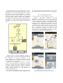
EasyTracker: An Android application for capturing mobility behavior
Alexandros Doulamis
Nikos Pelekis
Yannis Theodoridis
Dept. of Informatics
University of Piraeus
Piraeus, Greece
[email protected]
Dept. of Statistics & Insurance Sci.
University of Piraeus
Piraeus, Greece
[email protected]
Dept. of Informatics
University of Piraeus
Piraeus, Greece
[email protected]
Abstract — This paper presents EasyTracker, a mobile
application developed for the Android O/S that enable the
storage, analysis and map visualization of routes of mobile
users. Furthermore, it enable users to manually annotate part
of their routes with labels describing their activity and
behavior (e.g. “home having breakfast”, “travelling by car to
work”, etc.). Of equal importance, the application encapsulates
several state-of-the-art line simplification algorithms for
compressing the trajectories drawn from collected GPS
records, as well as segmenting trajectories into homogeneous
parts in order to facilitate automatic auditing of the user’s
manual annotation.
Keywords - EasyTracker; GPS data; trajectory; path; track;
privacy; compression; segmentation; Android OS
I.
INTRODUCTION
Nowadays, the number of users possessing and using
smartphones equipped by a GPS receiver increases rapidly,
while their interest for mobile applications that enable the
storage, analysis and visualization of the collected spacetime information is apparent.
There are already plenty of such general-purpose
applications, including “My Tracks” [1], AndAndo” [2],
“GPS Tracker” [3] and “EveryTrail” [4]. Apart from these,
there are a great number of applications developed for
specific groups of users. A few examples include
“Runkeeper” [5], “Endomondo Sports Tracker” [6] and
“Sports Tracker” [7] that support functionality mainly
focusing on sports/fitness. All of these have as main function
to store and display a route on a map (usually, Google
Maps), also extracting simple statistics, such as average
speed, distance travelled, etc.
In this paper, we present “EasyTracker” for Android O/S.
The core of EasyTracker is threefold. At first, EasyTracker
collects space-time points of user’s movement using a GPS
receiver, thus creating and visualizing a path (or trajectory)
followed by the user. In contrast to similar applications, the
collected path, to be stored in a server’s database, is sanitized
by filtering out locations that lie inside user-defined areas of
interest – sensitive areas where the user does not allow to be
tracked (e.g. around home, a hospital, etc.). This way,
EasyTracker provides end users with personalized privacy
functionality [8].
The second key functionality is that EasyTracker allows
a user to annotate parts of her track with labels and therefore
to describe her current activity (e.g. “stopped at café A”,
“driving towards office”) [9]. Such feature can turn out to be
very useful for automatic fill-in of surveys performed in
transportation science or for researchers working on activity
recognition who are usually restricted to use manually
processed surveys.
Third,
EasyTracker
encapsulates
state-of-the-art
algorithms that process in an online fashion the received
stream of GPS recordings and transforms it into meaningful
tracks, ready to be stored into a trajectory database [10] for
further analysis. Specifically, EasyTracker includes line
simplification methods that compress the incoming stream of
timestamped locations (thus reducing the storage cost),
which are then partitioned into homogeneous portions
according to some spatio-temporal criteria using a state-ofthe-art segmentation method [11]. According to this
segmentation, the track is split into portions (i.e. sub-tracks),
which can be labeled by tags that describe the corresponding
spatio-temporal behavior of the user (e.g. STOPPED, when
the speed is very low). This is important as it facilitates the
user (or some auditing algorithm) to compare her manual
annotations with the classified sub-tracks as provided by the
segmentation algorithm. The big picture that illustrates these
novel features of EasyTracker is depicted in Fig. 1.
The rest of the paper is organized as follows. Section II
presents related work. In section III, the various features of
EasyTracker are explained in more detail. Subsequently, we
provide a general overview of EasyTracker’s architecture
(section IV) and describe the challenges to develop for
different devices (section V). Section VI concludes and
proposes improvements for future work.
II.
RELATED WORK
The number of existing applications that make use of the
information captured by a GPS receiver is significant. To
obtain a better overview, we present the most successful
applications, by classifying them in different categories.
In the general-purpose category, which targets to people
who simply like to track and visualize their routes, Google’s
“MyTracks” [1] is the most famous application for Android
O/S. We have to note that this application is a relatively
simple tracker with no advanced features, however it has
more than 5 million downloads. Other similar applications
in the same category include “AndAndo” [2], “EveryTrail”
[4], which has more advanced features by allowing users to
add pictures or points of interest and create guides, and
“OruxMaps” [12], which allows utilizing various kinds of
maps.
also argue that the supported functionality is by far richer
than the functionality provided by current commercial apps.
III.
EASYTRACKER IN ACTION
A. Basic functionality enhanced with privacy filters
Common to all similar applications, the main
functionality of EasyTracker is to record a track and
visualize it in real time on a user-selected map. Thereby it
stores the geographical coordinates on a local database and it
is able to calculate useful statistics (total distance travelled,
average speed, etc.). Using the device orientation sensor, the
real heading can be calculated and displayed on a map and
on a built-in compass. The user has also the options to take
photos or set places (point of interests - POI) and associate
them to geographical coordinates, create notations to each
part of a track, view a stored track on a map or export a
saved track in a geographical file following one of many
well-known data formats like GPX, KML and CSV.
Figure 2: Screenshots of EasyTracker. Left: recording a new track, Right:
displaying a recorded track
Figure 1: The big picture of EasyTracker
Another category is about applications focusing on
sports/fitness. Here we find many specialized features like
the computation of calories consumption or the
measurement of heart rate utilizing internal or external
sensors; “RunKeeper” [5], “Endomondo Sports Tracker” [6]
and “runtastic” [13], to name a few.
Third, there exist applications designed to track lost
devices or devices that belong to another person (assuming
permission is granted). For instance, tracking a smartphone
is feasible nowadays with the assistance of GPS and
wireless networks. Applications of this type are, for
example, “Wheres My Droid” [14], “GPS Tracking Pro”
[15] and “GPS Tracker” [3].
We classify EasyTracker in the first category, since it
does not focus to a specific target group or application. We
Figure 3: Privacy filter of EasyTracker.
Left: Showing privacy area while recording a track;
Right: Setting privacy regions and respective levels of privacy
An important feature of EasyTracker is its ability to
choose among various maps (Google Maps, Open Street
Map and Microsoft Bing Maps), also the possibility to use
offline maps. The latter is very important when the user is
currently in an area that has no network or a bad connection.
Fig. 2 illustrates two screenshots of the application.
Departing from the features that are more or less
available in many other similar applications, to protect users’
privacy the application allows registering user-defined areas
inside where recording is not permitted. Such an area is
defined by a point (either set manually by providing exact
coordinates or by touching on the map) along with a desired
radius around this point and a characteristic name (e.g. home,
work, mam’s house). The user can specify up to five privacy
locations using a radius which is limited from 15 meter till
300 kilometers. Fig. 3 depicts screenshots of this privacy
filter.
B. Compressing incoming GPS feed
One of the differences between conventional GPSTrackers and EasyTracker is the exploitation of several
state-of-art algorithms which are responsible to decide
which GPS recordings to be saved in the stored trajectory so
as to minimize the mobile device’s storage cost.
EasyTracker incorporates four spatiotemporal compression
techniques for this purpose: algorithms to save a track to a
local data base: Minimal Time / Minimal Distance Method,
which is a component part of the Android SDK [16], Before
Opening Window (BOPW) [17], Normal Opening Window
(NOPW) [17] and Threshold Algorithm [18]. (The detailed
presentation of the above methods is omitted due to space
limitations.)
To demonstrate the results of compression achieved by
the above methods, we use the path illustrated in Fig. 4.
minimal time is set to 5 sec and minimal distance is set to
12 meters, the application checks every 5 sec whether the
user is 12 meters away from the previously stored point. If
yes, the point will be saved. Otherwise, it is omitted.
This method is very sensitive to the threshold values
chosen by the user. To demonstrate this, we recorded the
test path twice by varying the threshold values. For the first
track it is 3 sec and 10 meters while for the second it is 10
sec and 80 meters. Fig. 5 illustrates the results. It is obvious
that the larger the values the less the coordinates stored,
which affects the quality of the stored track. On the other
hand, if we choose small values to avoid this problem we
store many (perhaps redundant) points. The ‘optimal’ values
of course depend on the mode of movement (walking,
running, driving, etc.) and may be difficult to be known in
advance by the user.
Figure 5: Compressed tracks with Minimal time/distance method.
Left: Minimal Time = 3 sec / Minimal Distance = 10 m;
Right: Minimal Time = 10 sec / Minimal Distance = 80 m
Figure 6: Recorded tracks with the BOPW-algorithm.
Left: ED = 8 m; Right: ED = 15 m
Figure 7: Recorded tracks with the Threshold-method.
Left: threshold = 8 m; Right: threshold = 15 m
Figure 4: A test path for the comparison of compression techniques.
The Minimal Time / Minimal Distance Method [16] is
the simplest method to save coordinates. The user sets two
parameters: a value for the “minimal time” and a value for
the “minimal distance”. The first value determines when to
check the second value. If the second value is exceeded,
then the incoming coordinate will be saved. For example, if
The two methods proposed in [17], Before Opening
Window (BOPW) and Normal Opening Window (NOPW),
achieve a very good compression rate. The user gives as
parameter a distance threshold (Euclidean Distance - ED)
which is a bound on how much the original path can deviate
from the compressed one. However, a high ED value may
lead to loss of data which are crucial to represent well the
sketch of the movement, so the tradeoff between
compression and quality is still under question. In Fig. 6 we
record the test path using the BOPW algorithm with
different ED values.
In the first path (ED = 8 meters) the tracker stored only a
few geographical coordinates without losing any remarkable
information. On the contrary, in the right path (ED = 15
meters) the path is actually destroyed since only two points
(start and end point) are stored.
Different from the previous ones, the Threshold Method
[18] relies on the speed of the user; to achieve good results
the speed has to be constant. In Fig. 7 we recorded the
sample track twice (in the first the threshold was set to 8
meters while in the second it was 15 meters) and in both
cases the speed was constant at 30 km/h. As with the
previous techniques, we notice that also this cannot avoid a
loss in representativeness when the threshold is set to a high
value.
IV.
THE ARCHITECTURE OF EASYTRACKER
As already mentioned, the main features of EasyTracker
include the recording and storage of a track and the
visualization of a stored track on a map.
A. Recording a track
Only a few steps are required to record a track. As it is
illustrated in Fig. 9, the application at first verifies the GPS
signal. If it is available, the tracker starts storing the
coordinates. Whether a location is stored is the decision of
the compression method enabled by the user. Each time a set
of coordinates are stored into the database, the application
uses the TSA algorithm to segment, if necessary, the track
and calculates various useful statistics (total distance of the
track, average speed, etc.).
C. Manual annotation vs. automatic segmentation
EasyTracker allows the user to annotate parts of the track
with labels in order to describe her current activity (e.g.
“stopped at Acropolis museum”, “walking towards
Parthenon”) [9]. This way we allow the automatic annotation
of user’s activities, including her stops and movements. In
detail, the user has the option to select an annotation
tag/label which is attached to a specific part of the track, or
to type a smart text of her choice (Fig 8).
Figure 9: Recording and storing coordinates
B. Storing track data
We decided to store information in a local database in
order to avoid requiring Internet connection. For this
purpose, we make use of the Sqlite data base which is
embedded on the Android SDK [19]. The database is a
simple schema that contains the main information of a track,
the GPS coordinates it derives from, as well as the statistics
described above. Accompanying places (POIs) and pictures
are also stored in the database.
Figure 8: Selecting movement mode.
An important feature of EasyTracker is the usage of the
Trajectory Segmentation Algorithm (TSA), proposed in
[11]. TSA partitions tracks into homogeneous portions
according to their speed pattern. This segmentation splits the
track into portions (i.e. sub-tracks) where each of them can
be labeled by a tag that describes the corresponding speed
range (e.g. WALKING, assuming the speed pattern is in a
predefined range). This is important as it facilitates the user
to compare her manual annotations with the classified subtracks as given by the segmentation algorithm.
Figure 10: Visualizing information of a point (left), calculating distance
of two points (right)
C. Visualizing and exporting a track
EasyTracker has the function to display a recorded track
on a map, so that the user can analyze her stored track. In
particular, the user has the option to study each stored point
closer, calculate the distance between two different
geographical points, get more information about a stored
place or view a picture taken at this point (Fig. 10).
It is also feasible to export a stored track to a file format
appropriate for further processing (e.g. the general purpose
CSV, KML for visualizing the track in Google Earth, GPX
for GPS use).
V.
A DEVELOPER’S DISCUSSION
One of the major advantages of Android O/S is the
compatibility to many different devices and screen
resolutions. But it is exactly this that increases the degree of
complexity for the software developer. On the following two
sub-sections we discuss this challenge.
A. Devices with different displays
As already mentioned, there are several devices that
support Android. Except the various kind of sensors which
differs from device to device and the different hardware
performances, one of the biggest variances has to do with
the display screen, which is not only the size, but also the
screen density. Therefore, Android uses dpi (dots per inch)
instead of pixels [20]. Nevertheless, the developer should
make extra effort, especialy if graphics are used (Fig. 11).
Figure 11: EasyTracker’s main menu in different displays.
Left: 800x480 (high-dpi); Right: 240x380 (low-dpi)
B. Orientation-depentent devices
To make the work as user-friendly as possible, Android
has decided to support different device orientations. This
means that the application adapts to the current orientation
of the device, so the user can choose the desired orientation
depending on the circumstances. Frequently, this change
takes effect automatically by the O/S, but sometimes the
developer has to do it manually. To solve this, several
layouts for each orientation (mostly horizontal or vertical)
should be developed, see e.g. Fig. 12.
Figure 12: Display Track pre-menu in different orientations. Left:
vertical (portrait), right: horizontal (landscape)
VI.
CONCLUSION AND FUTURE WORK
In this paper, we presented EasyTracker, a mobile
application developed for the Android O/S that enables the
storage, analysis and map visualization of routes of mobile
users. In comparison with related applications, EasyTracker
provides novel functionality at three levels: (i) it enables
users to manually annotate part of their routes with labels
describing their activity and behavior, (ii) it encapsulates
several state-of-the-art trajectory compression algorithms
for a tradeoff between storage cost and quality of
movement’s representation, and (iii) it automatically
segments tracks according to a state-of-the-art trajectory
segmentation algorithm in order to facilitate automatic
auditing of the user’s manual annotation. As a fourth
(preliminary) contribution, it enables users to protect their
privacy by defining sensitive areas where recording is not
permitted.
This type of applications can be used in several fields,
from route planning and resources administration (e.g.
carpooling) to entertainment and social networking (e.g.
next generation location-based social networks).
Challenges for future work include the extension of TSA
algorithm in order to recognize for each track segment the
activities of the user in such a way as to enable the
automatic validation and auditing of the user’s annotation,
an energy saving policy since our application is used in
devices with limited energy resources, a possibility to detect
user’s position in non GPS-available areas (e.g. in indoors
environments or in subsurface regions) without loosing in
accuracy and a hybrid local – in the cloud storage schema
that would make it ready for social networking applications.
ACKNOWLEDGMENT
This work was partially supported by the European FP7
Open-FET project DATASIM “Data Science for Simulating
the Era of Electric Vehicles” (URL: http://www.datasimfp7.eu/).
REFERENCES
[1]
[2]
[3]
[4]
[5]
[6]
[7]
[8]
[9]
[10]
[11]
[12]
[13]
[14]
[15]
[16]
[17]
[18]
[19]
[20]
Google MyTrack. URL:
http://www.google.com/mobile/mytracks/ (accessed: 1 Jun.
2012)
Javi Pacheco, AndAndo. URL:
https://play.google.com/store/apps/details?id=com.javielinux.
andando (accessed: 1 Jun. 2012)
InstaMapper LLC, GPS Tracker. URL:
http://www.instamapper.com/ (accessed: 1 Jun. 2012)
GlobalMotion Media, Inc, EveryTrail. URL:
http://www.everytrail.com/ (accessed: 1 Jun. 2012)
FitnessKeeper, Inc, RunKeeper. URL: http://runkeeper.com/
(accessed: 1 Jun. 2012)
Endomondo, Sports Tracker. URL:
http://www.endomondo.com (accessed: 1 Jun. 2012)
Sports Tracking Technology Ltd, Sports Tracker. URL:
http://www.sports-tracker.com/ (accessed: 1 Jun. 2012)
N. Pelekis, A. Gkoulalas-Divanis, M. Vodas, D. Kopanaki,
and Y. Theodoridis. Privacy-Aware Querying over Sensitive
Trajectory Data, Proceedings of the ACM Conference on
Information and Knowledge Management (CIKM), 2011.
C. Parent, S. Spaccapietra, C. Renso, G. Andrienko, N.
Andrienko, V. Bogorny, M. L. Damiani, A. GkoulalasDivanis, J. Macedo, N. Pelekis, Y. Theodoridis, and Z. Yan,
“Semantic Trajectories Modeling and Analysis" ACM
Computing Surveys, to appear.
N. Pelekis, E. Frentzos, N. Giatrakos, and Y. Theodoridis.
HERMES: Aggregative LBS via a Trajectory DB Engine,
Proceedings of the ACM SIGMOD Conference, 2008.
C. Panagiotakis, N. Pelekis, I. Kopanakis, E. Ramasso, and Y.
Theodoridis. Segmentation and Sampling of Moving Object
Trajectories based on Representativeness, IEEE Transactions
on Knowledge and Data Engineering, 2011.
Jose Vasquez, OruxMaps. URL: http://www.oruxmaps.com
(accessed: 1 Jun. 2012)
Runtastic. URL: http://www.runtastic.com/ (accessed: 1 Jun.
2012)
Alienman Tech, Wheres My Droid. URL:
http://wheresmydroid.com/ (accessed: 1 Jun. 2012)
GPS Tracking Pro. URL:
https://play.google.com/store/apps/details?id=com.fsp.android
.c (accessed: 1 Jun. 2012)
Android developers, Location Manager. URL:
http://developer.android.com/reference/android/location/Locat
ionManager.html (accessed: 1 Jun. 2012)
N. Meratnia and R. A. de By. Spatiotemporal Compression
Techniques for Moving Point Objects, Proceedings of the
Extending Database Technology Conference (EDBT), 2004.
M. Potamias, K. Patroumpas, and T. Sellis. Sampling
Trajectory Streams with Spatiotemporal Criteria, Proceedings
of the Scientific and Statistical Database Management
Conference (SSDBM), 2006.
Android developers, SQLite Database. URL:
http://developer.android.com/reference/android/database/sqlit
e/SQLiteDatabase.html (accessed: 1 Jun. 2012)
Android developers, Supporting Multiple Screens. URL:
http://developer.android.com/guide/practices/screens_support.
html (accessed: 1 Jun. 2012)