1
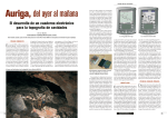
Hellenic Speleological Society
O-167
Title: Advances in computer-aided cave survey data acquisition; the Auriga Palm OS freeware for underground and field use
Section: Cave Surveying
Author: Luc Le Blanc, President, Société québécoise de spéléologie
Address: 5980, rue Saint-André, Montréal, Québec, CANADA, H2S 2K4, Contact: +1 514 277-7897 or [email protected], Web site: www.speleo.qc.ca/
Auriga, Keywords: Auriga, Cave surveying, Software, Cave electronics
470
Abstract
The underground use of the Auriga software drastically improves the
cave surveying process. By trading their traditional paper notebook for a
Palm OS PDA (Personal Digital Assistant, i.e. handheld computer) running Auriga for the input of the numerical survey data, cave surveyors
benefit from features targeted at yielding better cave maps faster. Survey
blunders are rapidly spotted, thanks to the real-time display (as new survey shots are input) of the topographical path of the cave, the display of
passage walls and lists of poorly-closed loops and orphan survey shots.
Also featured are sketching aids such as a user-configurable map grid, the
display of station coordinates using the sketching paper’s grid and the display of projected length of survey shots. Cave survey data can be viewed
in both graphical and tabular forms, with color cave maps or computed
coordinates lists. Supporting the use of geographic locations, either input
manually or through a serial link with a GPS, Auriga lets cave explorers
immediately know how close they are getting to other known cave passages or surveyed surface features. Auriga’s user-friendliness relies on a
wealth of user-customizable options as well as a smart user interface well
adapted to small PDA screens, even when used underground through the
window of a protective case. Acquired survey data can be transmitted via
IR to other PDAs, while a software “conduit” handles the bidirectional
exchange of data between the PDA and popular PC cave survey software.
Already in use in various countries, Auriga undergoes a rapid development, with several new releases a year. Upcoming features include loop
closure, blunder detection, electronic links with automated survey devices
and, ultimately, the ability to sketch passages walls and features directly
on the PDA screen. Auriga is available for free, in 3 languages (English,
French and Spanish), and comes with a comprehensive user manual and
online help.
Mots-clés: Auriga, Topographie de grottes, Logiciel, Électronique
souterraine
Résumé
L’utilisation d’Auriga sous terre améliore considérablement le processus de topographie des grottes. En remplaçant leur traditionnel carnet
de papier par un ANP (Assistant Numérique Personnel ou ordinateur de
poche) Palm OS exécutant Auriga pour la saisie des données numériques
de topographie, les topographes bénéficient de fonctionnalités destinées
à produire de meilleures topographies plus rapidement. La détection des
erreurs est facilitée grâce à un affichage en temps réel (au gré des visées)
du cheminement topographique de la grotte et des dimensions de galeries
ainsi que des erreurs de fermeture de boucle et des visées orphelines. Le
logiciel offre également des outils d’aide au dessin tels une grille graphique configurable, l’affichage des coordonnées des stations à l’échelle du
carnet et l’affichage en continu de la longueur projetée des visées. Les
données topographiques peuvent être revues tant en modes graphique
que tabulaire, avec une topographie en couleur ou une liste des visées
et des coordonnées calculées. Supportant l’utilisation de localisations
géographiques, acquises manuellement ou par un GPS connecté via un
lien sériel, Auriga permet aux explorateurs de se situer immédiatement
par rapport aux galeries déjà topographiées ou aux phénomènes de surface relevés. La convivialité d’Auriga repose sur un éventail d’options
et une interface intelligente bien adaptée au petit écran des ANP, même
lorsqu’utilisés sous terre à travers la fenêtre d’un étui protecteur. Les données acquises peuvent être transmises par faisceau infrarouge entre les
21-28 August 2005, Kalamos, Hellas
ANP, tandis qu’un «conduit» logiciel permet l’échange bidirectionnel
des données entre l’ANP et plusieurs logiciels de topographie de grottes
sur PC. Déjà utilisé dans divers pays, Auriga connaît un développement
rapide, avec plusieurs nouvelles versions par année. Parmi les fonctionnalités à venir figurent la fermeture des boucles, la détection des erreurs
grossières, des liens électroniques avec des dispositifs d’acquisition de
données automatiques et, ultimement, le dessin des galeries directement
sur l’écran de l’ANP. Auriga est disponible gratuitement, en trois langues
(français, anglais et espagnol), accompagné d’un manuel d’utilisation et
d’aide en ligne.
Text
Much has changed over the last 20 years in the field of cave surveying.
Most cave surveyors process their numeric data with PC-based programs,
while the number of hand-drawn surveys is ever decreasing, thanks to
sophisticated drawing programs and the availability of scanners to digitize
notebook sketches.
By contrast, the input of survey data has changed very little over that
period: the vast majority of cave surveyors still use a measuring tape, a
compass and a sighting inclinometer and jot down their measurements
into a waterproof paper notebook.
But the times are changing, thanks to the availability of Auriga, a cave
survey freeware that runs on Palm OS handheld computers.
Originally created in 1997 by Martin Melzer to help tune his compass/
clinometer electronic sensor box prototype, the Auriga project became
dormant around 1998. Luc Le Blanc resumed the software development in
2002, aiming at designing the perfect electronic replacement of the classical survey notebook. Auriga is now a user-friendly almost full-fledged
cave survey software, albeit with a strong input interface designed to be
used underground.
With universality in mind, pretty much everything is user-customizable:
•naming format and auto-incrementation scheme of survey stations;
• map units (length, angle, and slope 0 reference);
• handling of reverse headings and slopes (backsights);
• handling of passage dimensions;
• handling of unsaved data;
• handling of duplicate shots;
• hardware button use;
• various automated behaviors.
Auriga’s target is to suit the needs to survey a complex cave system
with several simultaneous teams, possibly with different instruments (e.g.
metric tape in small passages and Topofil in collectors) using different
measurement units (e.g. a Topofil counting in centimetres) and bearing
different calibrations. Of course, all this data must support easy merging
once back at camp.
Mixing instruments thanks to sessions
The ability to mix heterogeneous data is made possible with the use of
sessions, a concept already present in several Windows/Mac OS cave sur-
Hellenic Speleological Society
vey software. Each survey shot belongs to a session, i.e. an abstract time
period (its actual duration is left up to the user) during which survey shots
are taken. Each survey session consists of two sets of instruments, calibrations, measurement units, and some default settings. The data read from
the instruments can then be input “as is” into Auriga; the surveyor is not
bothered by the broken end of his metric tape, the magnetic deviation, or
the compass shift; the session takes care of these. When computations are
performed, Auriga simply uses the proper session settings to interpret the
survey data, without ever altering the original input data. In this respect,
Auriga is as faithful as a paper notebook.
Tight storage
Despite an effort to squeeze as much survey information as possible
into the meager 54 bytes used for each survey shot record in the Auriga
cave databases, limits are few. Length, heading, slopes, reverse headings
and slopes and passage dimensions are each stored with two-decimal precision as 16-bit integers, i.e. in hundredths of units. Survey shot length is
thus “limited” to 655.33 meters (or feet, depending on user choice), an
uncommon span in caves. Since survey data is stored in input units, no
rounding error due to meters-feet conversion can occur when presenting
the original data. In addition to basic survey data, a note of up to 255
characters (bytes) can be appended to each survey shot and session record,
and to the cave database as a whole. Auriga cave databases can hold up to
a maximum of 16 384 records (one per survey shot or session), a Palm OS
limit. This limit can be pushed several folds by combining cave databases
into networks.
Managing passages
Survey stations can be named with up to 8 characters, with user control
over the permitted character set (numeric, alphanumeric, punctuation, etc.)
The user can choose between a 4.4 format (e.g. “2.6”, “A31.74”) and an
8-character free format (e.g. “Cascade”, “X24-46b”.) The 4.4 format allows the use of series, a concept inspired by Toporobot. A series is simply
a suite of survey stations and shots sharing a common root (like “A2.0”,
“A2.2” and “A2.31b”) which can be acted upon collectively. As series are
usually, and appropriately, made equivalent to passages, their use allows
users to selectively hide passages from a crowded cave map, distinctively
colorize them in the map, exclude surface shots from total cave development, select the projection direction of a passage in the projected crosssection cave map view, or just navigate between passages when reviewing
survey shots. The sole prerequisite to manage survey shots as a series is
to have a “series-beginning survey shot”, i.e. a virtual survey shot linking the series-beginning virtual station to the rest of the cave (or to itself,
starting a new disconnected leg.) The series-beginning station must bear
the smallest station number within the series (e.g. station 2.3 cannot be the
beginning station of series 2 if there exists a physical station 2.1.) Since
series-beginning shots are virtual (zero-length) shots, the unused shot data
storage space in their database record can instead hold a geographic location (like the UTM co-ordinates of the cave entrance) or an absolute XYZ
co-ordinate - a convenient feature when working with cave subsets.
For those not familiar to the series concept or for compatibility with
software that ignore it, most series benefits have been extended to sessions, offering an alternate way to manage passages.
Sharing the data
If several teams are let loose surveying a cave, conflicts are to be expected (…) with regard to station names or session numbers. To circumvent these, Auriga offers various maintenance functions to rename or shift
stations names or series numbers, renumber or merge sessions, or move
survey shots to another session. Ideally, teams should harmonize their data
before merging it, in order to minimize tedious subsequent clean-ups.
Two mechanisms allow sharing survey data between teams: infrared
(IR) beaming and the Palm HotSync process.
IR beaming is the common device-to-device Palm OS data sharing
mode. Auriga can send a whole cave database, or a subset of it, to another
device. In the latter case, every survey shot sent is accompanied by its
corresponding session, so as to make the beamed data complete by itself.
If the cave database does not already exist on the target device, it is created and filled with the beamed data. Otherwise, a record-by-record merge
process is triggered. Similar but different survey shot or session records
are duplicated and logged into a text memo for subsequent clean-up by
the user. Otherwise, if the beamed records contain a note or other survey
data that records on the target device do not have, while start/end survey
stations are the same, records on the target device are simply updated with
this additional information.
The HotSync process takes place on the target PC (or Mac) through a
conduit launched by the HotSync Manager, a software component shipping with every Palm OS device. This process of synchronizing the Auriga cave databases with those present on the PC is a more complex process
than IR beaming because it runs between heterogeneous databases (Auriga and non-Auriga) and it is a bidirectional process (insertions, deletions
and modifications must be reflected on both sides.)
It is highly unlikely that another PC cave survey software would have
its internal data format match Auriga databases field for field. Some software recognize series, some don’t; and the same goes for reverse measurements, mixed direct and reverse shots, mixed measurement units, passage
dimensions, etc. Thus, in order to transfer the Auriga survey data to the
desktop software, the conduit may have to adapt this data to a format the
target software can understand. This can mean merging the session calibration with shot data, removing series-beginning virtual shots, inverting
reverse shots to make them all forward, etc. In the process, some information could be lost. To prevent this information loss, the conduit performs
a two-phase sync: the Auriga data received through the HotSync manager
is first stored into a mirror XML database on the PC before being adapted
for the target software. This way, if the survey data is modified via the
PC software, thus requiring a transfer back to Auriga (data consistency
between the PC and the Palm must be maintained if further Auriga surveying is to take place in that cave), the conduit can fetch from the mirror
database the previously dropped data and re-attach it back to the synced
records before writing them into the Auriga database. Note that this latter step of fully synchronizing both databases is not yet implemented. Of
course, the extent of this data removal and recovery depends on the target
software, some being more restrictive than others. The Auriga conduit
structure supports both the usual single user mode and a multiple user
mode where several users can collectively sync their data with the same
cave database; this choice is made within Auriga when creating a new
cave database.
The current Auriga conduit, developed by Christian Chénier, allows
the bi-directional exchange of survey data with Visual Topo and Compass,
but support for other desktop cave survey software will be added based
on demand.
Surveying with Auriga
Auriga can be used as:
• an electronic notebook to store numeric survey data and instantly
view the cave map while in the cave;
• a scientific calculator to convert survey shots into Cartesian coordinates while at camp;
• an input device to transfer survey data from the paper notebook to
the PC without wasting battery power.
14th International Congress of Speleology
471
Hellenic Speleological Society
The most common use for Auriga is to input survey data while in the
cave. But carrying a Palm underground? Once you accept that you must
treat a device as fragile as a Palm (compasses are also fragile) with proper
care, it is no problem. In easier caves, wrapping the Palm in a Ziploc bag
and carrying it inside the survey notebook (still required for sketching)
may be sufficient. Otherwise, Aquacase makes, for US$ 25, a watertight
soft case with a write-through film on the front. Screwed into the cover
of a regular survey binder, the setup allows for simultaneous input of numeric data into the Palm and sketching on the usual waterproof paper.
This setup was used for my own field testing, and Auriga was improved
accordingly to ease data input, up to the point where the usual stylus is not
required for most tasks: a field-aware self-adaptive custom alphanumeric
keypad with finger-tappable keys was developed for navigation between
fields and survey data input.
A configurable input Assistant further increases the user-friendliness
of the whole input process by automatically creating survey shots based
on the previous one, auto-incrementing station names (with both digits
and letters), popping-up the custom keypad when necessary, incrementally computing new survey shots, displaying the revised cave map. Everything is done to prevent mishaps that could result in data loss.
472
Computing the cave
Auriga performs, automatically and on demand, all the computations
required in order to display the cave map and essential statistics. In order
to handle every possible survey shot arrangement and to pave the way for
a future loop closure algorithm, a full-blown non-oriented graph is internally constructed to represent survey stations (nodes) and survey shots
(arcs) between them. An iterative algorithm scans in alternating directions
the list of survey shots in the cave database to compute XYZ Cartesian
station locations relative to the origin.
Any station can be manually selected as the Cartesian origin (0,0,0) of
the cave, or as a point with a known fixed offset from this absolute origin.
If the cave does not have a determined origin, the computation process
chooses the first survey station (sorted in alphanumeric order) as the origin and assumes a zero offset. It is also possible to assign a pre-determined
XYZ co-ordinate to a series-beginning or virtual survey shot (presumably
computed somewhere else), thus allowing the computation of “real” coordinates from a cave subset that does not include the cave origin.
Likewise, any virtual station owning a geographic location (UTM,
with or without altitude) can be manually selected as the geographic reference for the cave; after which any other survey station displayed in the
cave map can be queried for its geographic location!
Viewing the cave
Auriga offers a graphical display of the cave map display, with full
pan and zoom capability and the ability to graphically poke stations for
information, XYZ coordinates or geographic location. The line plot can be
displayed in top view or S-N, W-E, extended and projected profile views.
One convenient feature is the ability to get the orientation of a passage,
the inclination of a slope, or the distance between two points by simply
dragging the stylus on the screen. Orientation angles obtained through this
feature are automatically copied to the clipboard to allow quick pasting
into the projection angle selection dialog.
The cave map is probably the most compelling feature to use Auriga
underground: surveying with Auriga allows cavers to see the cave map
while the cave is being surveyed. Not only can survey errors be detected
faster, but it can orient the exploration process: by knowing right away
where the cave is heading to, surveyors can decide which way to take or
which passage to survey in priority. If a junction is expected, Auriga can
let cavers know how close they are from the other passage and eventually
21-28 August 2005, Kalamos, Hellas
keep hope… Actually, Auriga could become an incentive to survey while
exploring, a good practice in every respect!
Auriga also supports cave networks, where several caves can be
logically linked and geographically positioned on a common display.
This feature turns out to be very convenient not only to simultaneously
view closely located caves but also to display caves so large (in terms of
number of survey shots) that they had to be split into several sub-caves
(ex. Lechuguilla or Wind Cave.)
A recent addition is the Sketch to Scale dialog where survey station
coordinates are displayed according to the selected map scale and the
paper grid size, making the in-cave use of the ruler and protractor a thing
of the past.
What’s next?
The rising activity in the field of electronic data acquisition has
allowed Auriga to re-activate its serial link with sensing devices, starting with the compass/clinometer Revolution module from True North
Technology - others should come soon. Survey data can be fetched from
electronic devices and fed to the data input form in a fully assisted fashion.
This should give Auriga a great boost: cavers may be reluctant to bring
a Palm underground just to add features to their classic notebook, but
the prospect of an affordable electronic cave surveying process may well
become irresistible. Furthermore, with the recent addition of GPS support,
the tracking of the current surface location against a “moving map” of the
cave underneath is just months away!
The next feature to be implemented should be a loop closure algorithm
along with blunder (gross errors) detection. This will improve the detection and correction of survey errors while in the cave.
The ultimate future addition to Auriga will be the ability to sketch the
cave walls directly onto the Palm screen. This may sound like a heresy
to purists, but a full screen of drawing space for every survey shot, in
scale with the surveyor’s own visual perception, would possibly lead to
better sketches. This feature would definitely render the paper notebook
useless, while allowing cavers to come back to the surface with an almost
finished cave map. But the complexities of this feature, with regards to
curve handling, storage and conduit syncing could be the topic of an
article by itself.
Trying Auriga
The software can be downloaded from the Auriga homepage, along
with sample caves and a complete user manual. Do read the manual at
least once. Auriga is not complicated, but complex; the manual should
give you a good understanding of the underlying concepts and may help
you discover features that are not immediately obvious in the user interface.
If you do not have access to a Palm OS device, you can nonetheless
try the software under a free Windows-based emulator. Get the details in
the Auriga homepage.
Acknowledgements
Martin Melzer, for starting the Auriga project and thus providing the
initial proof of concept that convinced me to jump into this adventure
Christian Chénier, friend, fellow caver and fine beta tester, for his most
precious advice on concepts, strategies and user interface, and for writing
the data exchange conduit
Annick Normandin, my wife, for her understanding towards all this
time spent since 2002