1
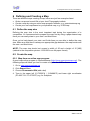
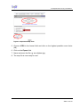
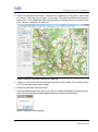
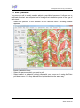
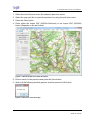
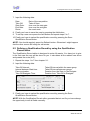
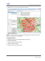
Air Navigation Race
Scoring & Visualisation Software
User manual
V0.2
Air Navigation Race Scoring & Visualization
Table of contents
1
2
3
4
5
Introduction .................................................................................................................. 3
Installing the ANR Software ........................................................................................ 3
Getting Started ............................................................................................................. 4
Managing Competitions............................................................................................... 5
Maps.............................................................................................................................. 5
5.1
Map import (map and world file) ............................................................................. 6
5.2
Online map import .................................................................................................. 7
6
Defining and Creating a Map ....................................................................................... 8
6.1
Define the map size ................................................................................................ 8
6.2
Create the map....................................................................................................... 8
6.3
Create the world file.............................................................................................. 10
7
Parcours ..................................................................................................................... 13
7.1
Generate Parcours with the parcours generator ................................................... 13
7.2
Edit a parcours ..................................................................................................... 15
7.3
Generate Parcours with dxf import ....................................................................... 16
8
Participants & Crews ................................................................................................. 18
8.1
Add participants.................................................................................................... 18
8.2
Edit participants .................................................................................................... 19
8.3
Add crews ............................................................................................................ 19
8.4
Edit crews............................................................................................................. 20
9
Qualification Rounds ................................................................................................. 20
9.1
Defining a Qualification Round ............................................................................. 21
9.2
Defining a Qualification Round by using the Qualification Round editor ................ 22
9.3
How to delete a crew ............................................................................................ 23
9.4
How to modify a crew ........................................................................................... 23
9.5
Binding trackers.................................................................................................... 23
9.6
Create a Starting list ............................................................................................. 23
10 Results ........................................................................................................................ 23
10.1 Import of logger files (gac format) ......................................................................... 23
10.2 Add penalties ....................................................................................................... 24
10.3 Modify penalties ................................................................................................... 25
10.4 Delete penalties.................................................................................................... 25
10.5 Individual results................................................................................................... 25
10.6 Ranking list........................................................................................................... 25
11 Trackers ...................................................................................................................... 25
12 Visualization ............................................................................................................... 25
13 Change History........................................................................................................... 28
ANR User manual
17.10.2012
Maurice Ducret, ANR Chairman
Seite 2 von 28
Air Navigation Race Scoring & Visualization
1 Introduction
The ANR User manual will help you to get familiar with the ANR software and finally
to set up an ANR competition. It may be used as short reference guide or as trainings
handbook. To use it as trainings handbook just follow the chapters in ascending
sequence.
Originally the ANR software was developed by students during several semester
works at the Gewerblich Industriellen Berufsschule in Bern (GIBB) it’s a technical
university located in Berne.
The ANR software as it is today is developed by Luc Baumann. Luc is software
engineer and he’s the designer of ANR live which he had developed when he was a
student at GIBB.
2 Installing the ANR Software
Before installing the ANR Software make sure you’ve already installed at least
Framework 4.0 and Google Earth Plugin Tool. The Links to download these
programmes are listed below:
•
•
Framework 4.0: http://msdn.microsoft.com/en-us/netframework/aa569263
GE Plugin:
http://www.google.com/earth/explore/products/plugin.html
You can either start the ANR software direct from the server by left click or download
the start file to your computer by right click on the file (save to). The ANR software
you may download or start by using the following link:
•
ANR Scoring & Visualisation Software:
http://code.google.com/p/anrl/downloads/detail?name=ANRL-ClientStarter.exe&can=2&q
ANR User manual
17.10.2012
Maurice Ducret, ANR Chairman
Seite 3 von 28
Air Navigation Race Scoring & Visualization
3 Getting Started
The ANR Scoring & Visualization software is ease of use designed. Means for setting
up and scoring a competition you can simply follow the overhead menus from left to
right to bring it to success.
After you’ve started the ANR Scoring & Visualization software you have to create an
own user account. This allows you to manage your own competitions (maps,
parcours, participants, crews, qualification rounds and rankings).
1. Click on the server menu and choose Connect.
Figure 3-1 Server menu
2. Use the default ANRL Server (46.163.65.74) and type in your e-mail and
Password, then click Register.
Figure 3-2 Server menu Register
NOTE: You’re free to use any Username & Password you want. You have to
Register only once (the first time you’re using the ANR Scoring & Visualization
software), for the next logins just use the Login button after you typed in your
personal Username & Password.
ANR User manual
17.10.2012
Maurice Ducret, ANR Chairman
Seite 4 von 28
Air Navigation Race Scoring & Visualization
4 Managing Competitions
In the Competition Menu you have the option either to create a new competition or to
select an existing competition. Each competition acts like a data folder which
contains the competition related maps, parcours, participants, crews, qualification
rounds, rankings and finally the visualization.
Figure 4-1 Competition menu
To use or edit a competition you may either choose an already created competition
or you can build up a new one.
5 Maps
In the maps menu you are able to edit and manage your maps within a competition.
There are different ways how to implement a map:
• Implementing a geo referenced map and the corresponding world file.
• Implementing a map by using the online map import.
ANR User manual
17.10.2012
Maurice Ducret, ANR Chairman
Seite 5 von 28
Air Navigation Race Scoring & Visualization
5.1 Map import (map and world file)
1. Click on the Maps menu.
2. Click the New button.
3. Click the Select Map button and choose the map file you would like to import e.g.
schipkau.jpg.
4. Click the Select World File button and choose the corresponding world file for the
imported map e.g. schipkau.jgw.
Figure 5-1 Maps menu
5. To finish the map import you have to name and to save it. Just Click in the name
folder and define a name then press the Save button.
6. The map is now ready for generating parcours!
ANR User manual
17.10.2012
Maurice Ducret, ANR Chairman
Seite 6 von 28
Air Navigation Race Scoring & Visualization
5.2 Online map import
1. Click on the Maps-Menu and select “Map import from Maps”. It may take some
time because of the connection with Google Maps.
2. Enlarge your Window until you can see the whole map selection.
3. Insert a name in the “name”-Field.
4. Change the selected map by clicking with the RIGHT mouse button. Change the
zoom level by using your mouse wheel or the slide bar on the left. To save the
Map you need to enter a name and use zoom level 11.
5. Save the map and use it to generate a parcour!
ANR User manual
17.10.2012
Maurice Ducret, ANR Chairman
Seite 7 von 28
Air Navigation Race Scoring & Visualization
6 Defining and Creating a Map
There are different ways creating a map, below are just few examples listed:
•
•
•
Order a map and a world file at your local Topography institute
Create a map by using an online map program software, e.g. openstreetmap.org
Create your own map based on your personal map, e.g. ICAO map
6.1 Define the map size
Defining the map size is the most important task during the organization of a
competition. It’s recommended to prepare the map first by using a paper based map
there you can easily draw in your start- and finish-lines.
Once you’ve had placed your start- and finish-lines you are able to define the map
size. Make sure that there is always an appropriate gap between the map border and
the start- and finish-lines.
NOTE: The map size should not exceed a width of 20 and a height of 15 [NM]
(related to the competition printout 1:200’000 to an A4 paper format).
6.2 Create the map
6.2.1 Map from an online map program
A good map online program is Openstreetmap (http://www.openstreetmap.org/). The
following steps will show you how to create a map for the ANR software.
1. Go to www.openstreetmap.org
2. Click Export Menu
3. Choose Osmarender Bild (add a dot)
4. Type in the upper left (51.72522°N / 13.54989°E) and lower right coordinates
(51.46871°N / 13.97706°E) e.g. for Schipkau:
ANR User manual
17.10.2012
Maurice Ducret, ANR Chairman
Seite 8 von 28
Air Navigation Race Scoring & Visualization
Figure 6-1 Openstreet Map form
5. Choose JPEG in the format field and click on the highest possible zoom factor
(12).
6. Click on the Export field.
7. Name and save the file e.g. as schipkau.jpg.
8. The map file is now ready for use!
ANR User manual
17.10.2012
Maurice Ducret, ANR Chairman
Seite 9 von 28
Air Navigation Race Scoring & Visualization
6.3 Create the world file
A world file is a plain text computer data file used by geographic information systems
to georeference raster map images.
Small-scale rectangular raster image maps can have an associated world file for GIS
map software which describes the location, scale and rotation of the map. These
world files are six-line files with decimal numbers on each line.
You may either create a world file by your own calculating all the necessary
parameters (not usermanual part) or by using an online world file calculator, e.g. the
tool provided at freegeographytools: http://freegeographytools.com/2009/onlineworldfile-calculator
1. Before creating a world file you should know following parameters of the map:
•
•
•
•
Upper left corner coordinates [X.XXXXX°N / X.XXXXX°E]
Lower right corner coordinates [X.XXXXX°N / X.XXXXX°E]
Pixel width: [pixels]
Pixel height [pixels]
2. Open the freegeographytools link: (http://freegeographytools.com/2009/onlineworldfile-calculator)
3. Click the following Link: World File Calculator
ANR User manual
17.10.2012
Maurice Ducret, ANR Chairman
Seite 10 von 28
Air Navigation Race Scoring & Visualization
4. Type in the given map parameters.
E.g. for the Schipkau map:
Make sure that you choose the right “wind direction” (N, E). After you’ve had type
in all the parameters you have to press the Calc Button. The world file results will
appear in the world file window.
5. Create on your desktop or in a directory a new txt file.
Press the right mouse button, choose New and then click Text Document.
ANR User manual
17.10.2012
Maurice Ducret, ANR Chairman
Seite 11 von 28
Air Navigation Race Scoring & Visualization
6. Copy and paste the given parameters from the world file calculator into the txt file.
7. Rename the txt file. First save and close the txt file, then Rename it with a name
you like, e.g. schipkau. The file extension must be renamed as *.jgw file.
8. The world file is now ready for use!
ANR User manual
17.10.2012
Maurice Ducret, ANR Chairman
Seite 12 von 28
Air Navigation Race Scoring & Visualization
7 Parcours
The Parcours menu allows you to generate, edit and import parcours on a defined
map. Finally the Competition Map of each qualification round will be created with the
Parcours menu.
7.1 Generate Parcours with the parcours generator
1. Select generate parcours in the submenu of the Parcours menu. Following
window appears:
Figure 7-1 Parcours generator
2. Select the map you like to add a parcours on it with the pull down menu.
3. Press the Clear button.
ANR User manual
17.10.2012
Maurice Ducret, ANR Chairman
Seite 13 von 28
Air Navigation Race Scoring & Visualization
4. Press the Add start line button. Create a line (defined by two points, each point
you have to click by your mouse) on the map. The start line defines all parcours
start points. Then create the parcours direction by clicking with your mouse a third
time. Here an example of a start line:
Figure 7-2 Parcours generator defining of a start line
5. Toggle or choose the Parcours length and the Corridor width. The Corridor count
is for the moment just a place holder.
6. Press the Generate Parcour button.
7. If the pre-defined parcours fits for you give it a name and press the Save button.
Wait until the following window appears and then press the OK button:
Figure 7-3 Parcours save message
ANR User manual
17.10.2012
Maurice Ducret, ANR Chairman
Seite 14 von 28
Air Navigation Race Scoring & Visualization
7.2 Edit a parcours
The parcours edit is mostly used to adjust a pre-defined parcours. It allows you to
reallocate the start- and endpoint and to change the intersection points of the legs of
each track.
1. Select edit parcours in the submenu of the Parcours menu. Following window
appears:
Figure 7-4 Parcours editor
2. Select the parcours which you want to edit.
3. Select a start- or endpoint (circles) either with your mouse or by using the Point
pull-down menu. You may also edit the leg intersections the same way.
ANR User manual
17.10.2012
Maurice Ducret, ANR Chairman
Seite 15 von 28
Air Navigation Race Scoring & Visualization
4. You may drag the circle (start- or endpoints) with your mouse or directly toggle in
the coordinates you want:
Figure 7-5 Parcours edit menu startpoint movement
5. If the edited parcours fits for you give it a name and press the Save button. Wait
until the following window appears and then press the OK button:
Figure 7-6 Parcours save message
7.3 Generate Parcours with dxf import
Another option is to create a parcours by using a CAD-System e.g. AutoCAD. The
advantage of the CAD is that you have the possibility to draw the parcours legs as
you want.
ANR User manual
17.10.2012
Maurice Ducret, ANR Chairman
Seite 16 von 28
Air Navigation Race Scoring & Visualization
1. Select from the Parcours menu the submenu parcours import.
2. Select the map you like to import the parcours by using the pull down menu.
3. Press the Clear button.
4. Press either the Import DXF (WGS84 Switched) or the Import DXF (WGS84)
button (Depends on the dxf format).
Figure 7-7 Generate parcours with dxf import
5. Enter a name for the parcours and press the Save button.
6. Wait until the following window appears and then press the OK button:
Figure 7-8 Parcours save message
ANR User manual
17.10.2012
Maurice Ducret, ANR Chairman
Seite 17 von 28
Air Navigation Race Scoring & Visualization
8 Participants & Crews
In this section you’ll learn to add and edit participants and to build up and edit crews
out of it. Finally you’re able to generate the Participants list (pdf format).
8.1 Add participants
1. Click on the Participants menu. Following entry mask will appear:
Figure 8-1 Participants menu
2. To add a new participant press the New button.
3. Enter the Name and Firstname of the participant into the fields.
4. Finally you have to add a photo. Press Add Picture and select the photo of the
participant.
5. Press Save button.
NOTE: You have always to add a photo otherwise you’re not able to save the
participant.
ANR User manual
17.10.2012
Maurice Ducret, ANR Chairman
Seite 18 von 28
Air Navigation Race Scoring & Visualization
8.2 Edit participants
1. By clicking on the participant you would like to edit the entry fields will be
activated. You’re able to change the First name, Name and the Photo of the
participant.
2. After editing the participant you have to save your entries by pressing the Save
button.
8.3 Add crews
1. Click on the Crews menu. Following entry mask will appear:
Figure 8-2 Crews menu
2. To add a crew press the New button.
3. Enter the requested data into the entry fields:
ID:
CNumber:
Color:
AC:
Nationality:
ANR User manual
reserved for the ANR software and will be automatically created
Competition number used for the hole competition
Color used for the visualization later on
Type of Aircraft
Crew Nationality
17.10.2012
Maurice Ducret, ANR Chairman
Seite 19 von 28
Air Navigation Race Scoring & Visualization
4. Select the pilot and the navigator by clicking on the listed names and press either
the Add Pilot or Add Navigator button.
5. Press Save button.
8.4 Edit crews
1. By clicking on the crew you would like to edit the entry fields will be activated.
You’re able to change the CNumber, Color, AC, Nationality, Pilot and Navigator.
2. After editing the crew you have to save your entries by pressing the Save button.
Figure 8-3 Crews menu editing
NOTE: You should regularly press the Refresh button. Otherwise it might happen
that the other menus still using the old entries.
9 Qualification Rounds
The Qualification Rounds menu allows you to manage the qualification rounds within
a Competition. You may create all the qualification rounds before a competition
event. If you do so you’re well prepared during the competition and fast to adapt or
change something in the individual qualification round if needed.
ANR User manual
17.10.2012
Maurice Ducret, ANR Chairman
Seite 20 von 28
Air Navigation Race Scoring & Visualization
9.1 Defining a Qualification Round
1. Press the New Qualification Round button.
2. Enter the requested data into the entry fields and select the parcours which you
like to use:
ID:
reserved for the ANR software and will be automatically created
Name: Name for the Qualification round, e.g. first qualiround
Parcour: Select the parcours
3. Define the Take-off line by entering the WGS84 coordinates. The Take-off line is
definded as a line 90 degrees to the runway heading in use. Normally placed in
the middle or at the end of the runway.
4. To implement the crews which should participate press the New button.
Figure 9-1 Qualification Rounds menu
5. The Start ID will be given automatically but you’re free to change it as you like.
6. Select the crew you want from the pull down menu.
ANR User manual
17.10.2012
Maurice Ducret, ANR Chairman
Seite 21 von 28
Air Navigation Race Scoring & Visualization
7. Input the following data:
Date:
Take Off:
Start Gate:
End Gate:
Route:
Date of the competition
Take-off time
time over the start gate
time over the end gate
the used route
8. Finally you have to save the crew by pressing the Add button.
9. To set up a new crew press the Add button and repeat steps 5 to 7.
10. Finally you have to upload the qualification round by pressing the Save
Qualification Round button.
NOTE: You should regularly press the Refresh button. Otherwise it might happen
that the other menus still using the old entries.
9.2 Defining a Qualification Round by using the Qualification
Round editor
The Qualification Round editor is designed to make life easier. You have just to give
in the first crew the rest will be done for you. It calculates all the related crew times
and presets the route (A-D).
1. Repeat the steps 1 to 7 from chapter 9.1.
2. Input the following data:
Take-Off Interval:
Interval between Start time:
Parcour duration:
Take Off-Startgate-Time:
Take-Off interval within the same group
Take-Off interval between groups
Duration from the Start- to the Endgate
Duration from Take-Off to Startgate
Figure 9-2 Qualification Round editor
3. Finally you have to upload the qualification round by pressing the Save
Qualification Round button.
NOTE: With the Qualification Round editor generated data is not fix you have always
the opportunity to edit all fields manually.
ANR User manual
17.10.2012
Maurice Ducret, ANR Chairman
Seite 22 von 28
Air Navigation Race Scoring & Visualization
9.3 How to delete a crew
1. You may delete a crew by clicking on it in the overview area and then click on the
Delete button.
2. Finally you have to upload the qualification round by pressing the Save
Qualification Round button.
9.4 How to modify a crew
1. You may modify a crew by clicking on it in the overview area.
2. Change the entries which you want.
3. Press the Modify button.
4. Upload the qualification round by pressing the Save Qualification Round button.
9.5 Binding trackers
Binding trackers is used to connect a tracker to a specific crew. It’s just needed for
ANR Live otherwise you can leave it.
1. Click on the crew in the overview area which you want connect with a tracker.
2. Set a Tick to the tracker you want in the Tracker(s) pull down menu.
3. Upload the qualification round by pressing the Save Qualification Round button.
9.6 Create a Starting list
To generate the Starting list per qualification round just press the Export Startlist To
PDF button and save the file.
10 Results
With the Results menu you’ll be able to import the logger data (*.gac format) and it
will do the scoring for you. You can judge the results and when necessary you’ll be
able to add, edit or delete the scoring entries.
The Results menu generates for you the Ranking list and the Individual Results per
Qualification round.
10.1 Import of logger files (gac format)
1. Select the Qualification round for the scoring from the pull down menu.
2. Select the crew you want to score by clicking on it.
3. Press the Upload GAC-File button.
4. Choose the *.gac file from the crew you want to score.
5. During the upload two message windows appear. Please confirm them.
6. Press the Refresh button and choose the Qualification round again.
ANR User manual
17.10.2012
Maurice Ducret, ANR Chairman
Seite 23 von 28
Air Navigation Race Scoring & Visualization
7. Repeat step 1 to 6 for each crew you want to score.
Figure 10-1 Results menu
NOTE: It’s important that you always press the Refresh button after a new entry! It’s
used for a proper server communication.
10.2 Add penalties
1. Select the crew you like to add penalties by clicking on it.
2. Press the New button.
3. Toggle in the points and the reason.
4. Press the Add/Save button.
5. Press the Save List to Server button.
ANR User manual
17.10.2012
Maurice Ducret, ANR Chairman
Seite 24 von 28
Air Navigation Race Scoring & Visualization
10.3 Modify penalties
1. Select the crew you like to modify penalties by clicking on it.
2. Click on the penalty you would like to modify.
3. Change the points and if necessary the reason.
4. Press the Add/Save button.
5. Press the Save List to Server button.
10.4 Delete penalties
1. Select the crew you like to delete penalties by clicking on it.
2. Click on the penalty which you like to delete.
3. Press the Delete from List button.
4. Press the Add/Save button.
5. Press the Save List to Server button.
10.5 Individual results
To generate the Individual results per qualification round just press the Export
Results to PDF button and save the file.
10.6 Ranking list
To generate the Ranking list per qualification round just press the Export Toplist to
PDF button and save the file.
11 Trackers
The Trackers menu is used for manage the trackers. You can name the trackers and
bind them to specific crews. The trackers menu works at the moment in beta modus
and is still under development.
12 Visualization
The Visualization menu is used for investigate a specific log or for presentation
purpose. You have the opportunity to present just one or more crews by adding a tick
to the crew you want to see.
1. Choose the Visualisation menu.
2. Select the qualification round (Q-Round) you like to see by choosing via the push
down menu.
3. Select the crew or crews you like to see by adding a tick.
ANR User manual
17.10.2012
Maurice Ducret, ANR Chairman
Seite 25 von 28
Air Navigation Race Scoring & Visualization
Figure 12-1 Visualization menu
4. To view the crew log(s) in different positions press the Start Google Earth button.
The crew log and the used parcour automatically appear in the Google Earth
window. The navigation and handling is the same as in Google Earth.
Figure 12-2 Viewing the Crew log's by using Google Earth
ANR User manual
17.10.2012
Maurice Ducret, ANR Chairman
Seite 26 von 28
Air Navigation Race Scoring & Visualization
If you would like to see the ranking you have just to press the Show Ranking button.
Later on the same button is used to show the online ranking during a qualification
round.
ANR User manual
17.10.2012
Maurice Ducret, ANR Chairman
Seite 27 von 28
Air Navigation Race Scoring & Visualization
13 Change History
Version Author
0.1
Maurice Ducret
0.2
Maurice Ducret
ANR User manual
First edition
Following Chapters added:
8 Participants & Crews
9 Qualification Rounds
10 Results
11 Trackers
12 Visualization
17.10.2012
Maurice Ducret, ANR Chairman
Seite 28 von 28