1
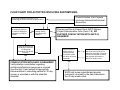
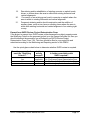
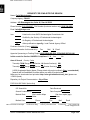
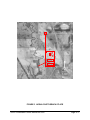
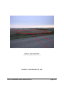
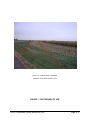
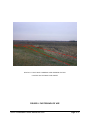
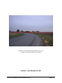
SECTION 3: ARCHAEOLOGICAL RESOURCES
Table of Contents:
Section 3
Flow chart for activities involving earthmoving
Introduction
Projects not normally requiring SHPO review
Quick-look chart for determining if SHPO consultation is
necessary using the qualifying criteria
Quick-look chart for determining whether SHPO review is required
3.2
3.3
3.3
3.5
3.7
Appendices
A The Archaeological Site File Search
B Preparing a Submittal for Review
C Example Submittal for SHPO Review
SHPO Consultation User’s Manual 04.2005
Page 3.1
FLOW CHART FOR ACTIVITIES INVOLVING EARTHMOVING
Are there any standing structures or nonarchaeological resources within the project APE?
Consult Section 2 for Projects
Involving Architectural/historical
Resources
Yes
No
Does the action meet
the Qualifying Criterion
#1 or #2 for categorical
exemption from SHPO
review?
No
No
Is the action an
exempt activity
according to the
PMOU?
Yes
Yes
Does the action meet
Qualifying Criterion #3
for categorical
exemption from SHPO
Review?
Yes
No
CONSULTATION WITH SHPO IS REQUIRED!
Verify whether consultation regarding
architectural/historical resources is required
(see Section 2) and submit all appropriate
documentation to consulting parties for 30-day
review, in accordance with the submittal
checklist.
Prepare and file an Exempt from SHPO Review,
Project Determination Form (Form 1.B). NO
FURTHER CONSULTATION WITH SHPO IS
REQUIRED!
Did you receive a
30-day notice of
receipt via email
from SHPO within
one week of project
submittal?
No
Your submittal was incomplete
and will be returned to you for
additional information. Carefully
review your submittal checklist
and resubmit information to
SHPO for 30-day review.
Yes
SHPO will review submittal and provide
comments via email by the date indicated in
the 30-day email notice.
SECTION 3: ARCHAEOLOGICAL RESOURCES
INTRODUCTION
The guidance in this section is applicable to projects involving earthmoving that could
disturb archaeological deposits, features, ruins, and/or cultural landscapes. Section 3
will discuss the criteria for categorical exemption of certain earthmoving activities not
normally requiring SHPO review and how to apply them. It will cover a list of activities
that have been categorically exempted from SHPO review, the appropriate procedures
for coordinating consultation with the SHPO on non-exempt activities, and the
documentation standards that have been established for SHPO consultation.
PROJECTS NOT NORMALLY REQUIRING SHPO REVIEW
Some earthmoving projects have greater potential to adversely affect significant
archaeological properties than do others. For instance, the construction of a new fiveacre sewage treatment plant on a ‘raw land’ alluvial terrace has much greater potential
to encounter a significant prehistoric site than would a similar project located in an
upland area that had been profoundly disturbed by a previous highway project.
Qualifying Criteria:
The following is a list of qualifying criteria. These are the first questions you should ask
to determine whether SHPO consultation is required. If either Criteria 1 or 2 and
Criterion 3 are met document the determination in the file using the Exempt Project
Determination Form and you are done. No SHPO consultation regarding archaeological
resources is required. However, it may still be necessary to complete consultation with
SHPO regarding Architectural/Historical resources that may be involved (please see
Section 2).
1. The Area of Potential Effect (APE) has been intensively surveyed after 1989
and determined by the federal agency not to contain historic properties, and
this finding was accepted by the SHPO. (Please note that an activity can be
excluded from SHPO review under Criterion 1 only if Criterion 3 also applies).
It is assumed that archaeological surveys performed after 1989 employed
techniques that are consistent with current standards. Most of the archaeological
survey coverage for the State of Iowa has been digitized and placed on the I-Sites
geographical information system database (GIS) maintained by the University of
Iowa Office of the State Archaeologist (OSA) in Iowa City.
Because of the sensitivity of the information, I-Sites offer two levels of on-line
accessibility. The public access site contains basic information that identifies the
number of reported archaeological sites by township section. Site and survey
locations are not provided. The professional access site is available only to
professionals who are registered with the OSA. This side of I-Sites not only
identifies site and survey locations, but also provides links to other archaeological
databases.
SHPO Consultation User’s Manual 04.2005
Page 3.3
Information regarding past survey work may also be obtained by those with a
demonstrated need-to-know by consulting the records at SHPO and at the OSA.
We ask that patrons contact us in advance to ensure that SHPO staff will be able to
assist in accessing the requested files.
2. If the APE has been profoundly disturbed. (Please note that an activity can be
excluded from SHPO review under Criterion 2 only if Criterion 3 also applies).
One misconception frequently held by project proponents is that since a land parcel
has been cultivated - sometimes for decades - it has been previously disturbed and
therefore no significant archaeological deposits could possibly remain. While the
land may have been subject to past agricultural disturbance, it may not have been
profound. In other words, the potential for significant archaeological deposits
remains.
‘Profound disturbance’ occurs when a past activity or activities have physically
altered the three-dimensional Area of Potential Effects (APE) in its entirety to the
point where there is no potential for an archaeologically significant property to
remain.
One must remember that the project APE is three-dimensional, and while there may
be no apparent signs of a site located at the surface, intact deposits and features
may be present well-below the modern land surface and still within the APE. In
Iowa, prehistoric archaeological sites have been discovered at depths from 20 to 25
feet below surface - and deeper.
In order to cite exclusion from SHPO review under Criterion 2, profound disturbance
of the entire APE must be demonstrated through archival sources.
3. The project will NOT involve buildings, districts, objects, structures, sites, or
landscapes in the APE that are more than 50 years old. (Please note that an
activity cannot be categorically excluded under Criterion 3 alone, but must also meet
the conditions of either Criteria 1 or 2).
An OSA archaeological site file search is strongly recommended as a first step for all
projects that involve earthmoving (see Appendix 3.A, and Appendix 3.B, Figures 11
and 12).
If, in the absence of other types of properties that are 50 years in age or older, an
OSA search reveals the presence of an unevaluated archaeological site in or
immediately adjacent to the project APE, then exemptions under criteria 1 and 2 do
not apply.
If, on the other hand, an archaeological site (in the absence of other types of
unevaluated properties that are 50 years in age or older) was identified and
SHPO Consultation User’s Manual 04.2005
Page 3.4
evaluated as Not National Register Eligible by a survey conducted after 1989 that
completely covered the current APE and SHPO concurred with the findings of the
survey and the National Register evaluation; or, the site, and the whole of the
current APE, were profoundly disturbed by a previous earthmoving event, then
Criterion 1 and 2 would apply.
Please remember that the OSA site file search only reports the existence of reported
archaeological sites. So, a negative search does not necessarily mean that there
are none present and that the project is automatically exempted from SHPO review.
There are many archaeological sites in the state that have never been reported and
do not appear in the State’s inventory, but are known to local collectors and
historians. Additionally, the absence of archaeological sites in the State’s inventory
for any given parcel of land may merely indicate that the area in question has never
been systematically surveyed for archaeological resources.
It must be remembered that the project proponents are not only responsible for
identifying known sites, but any sites that might be present within the APE that are
presently unknown. Information on the eligibility of an archaeological site can be
obtained by contacting the SHPO Inventory Coordinator (see Appendix 1.B). Please
note that the site National Register eligibility recommendations on the completed
Iowa Archaeological Site forms does not reflect whether the SHPO concurred with
those recommendations. The National Register archaeological site status database
maintained by the SHPO is the only source that contains the records of SHPO
findings.
Finally, one must remain vigilant of the undertaking’s potential to cause indirect
effects to other types of properties such as buildings and districts. For instance, a
project that proposes the construction of apartments on an infill lot in a large city
may be exempt from SHPO’s archaeological review but it may still require review
from its Architectural Historian particularly if the activity will take place within the
boundaries of an historic district or adjacent to an individually eligible or listed
property.
If you have difficulty in applying the criteria or have any questions concerning them,
contact either the review staff at SHPO or the Environmental Review Officers at
IDED or DNR for assistance.
Use the quick-glance chart below to determine if SHPO consultation is necessary using
the qualifying criteria.
Does
Does the activity qualify
criteria 3
Is further consultation with
for exemption under
apply?
SHPO required?
Criteria 1 or 2?
No
Yes
Yes
No
No
Yes
Yes
Yes
*No
* Assumes the absence of other types of historic properties.
SHPO Consultation User’s Manual 04.2005
Page 3.5
Exempt Activities:
If the undertaking does not meet the qualifying criteria above, but is included in the
exempt activity list below, the project will have little potential to affect a property, even if
historic properties are present. If any of the following are met, document the
determination in the file using the Exempt Project Determination Form and you are
done. No SHPO consultation regarding archaeological resources is required. However,
it may still be necessary to complete consultation with SHPO regarding
Architectural/Historical resources that may be involved (please see Section 2).
The following activities are considered exempt from further review by the SHPO
archaeologist because they have limited potential to affect historic properties:
1.
2.
3.
4.
5.
6.
7.
8.
9.
10.
11.
12.
13.
14.
15.
16.
17.
18.
Photoscopic pictures and video of water and/or sewer pipe.
Re-lining of water and/or sewer pipe.
Point repairs of water and/or sewer pipe.
Hydrant replacements
Manhole cover replacements.
New/replacement service lines and related appurtenances involving boring
or slit trenches up to 6” (inches) in width.
Equipment replacement, purchase, removal, and/or installation.
Disturbance confined to the current footprint of the compound such as
buildings, water treatment plants, and/or sewer treatment plants.
Directional boring of utility lines without sending or receiving pits.
Connecting pits relating to directional boring for utility lines no bigger than
10 feet by 10 feet.
Parallel water and/or sewer mains installed within 5 feet of the original
(existing) routes and if no known National Register of Historic Placeslisted or eligible sites or historic districts are within the Area of Potential
Effects.
Wells in existing well fields.
Geotechnical borings and environmental monitoring wells if no recorded
sites are in the vicinity.
Replacement of concrete or asphalt sidewalks.
Replacement (demolition) of water towers less than 50 years old on the
same building parcel less than 1 acre in size when the new tower is not
over a 10% increase in capacity or 20 feet in height as compared to the
existing water tower.
Utility upgrades without land disturbance.
Parking lot rehabilitation or construction of less than one acre in size,
located on row-cropped agricultural land provided that any ground
disturbance activities will be confined to the plowzone, which generally
extends 10 to 12 inches below surface.
Overhead power line and telecommunication cable replacement.
SHPO Consultation User’s Manual 04.2005
Page 3.6
19.
20.
21.
Resurfacing and/or rehabilitation of existing concrete or asphalt roads,
drives, or entries where the area is within both existing horizontal and
vertical alignments.
Conversion of an existing gravel road to concrete or asphalt where the
area is within to existing horizontal and vertical alignment.
Pavement widening and/or should construction and the addition of
auxiliary lanes, such as turn lanes or climbing lanes where the area is
within both existing horizontal and vertical alignment of an existing rightor-way.
Exempt from SHPO Review, Project Determination Form:
If the project is exempt from SHPO review, either because the subject property meets
the Qualifying Criteria or the proposed project is on the Exempt Activities list, then you
should document the exemption on an Exempt from SHPO Review Project
Determination Form (Form 1.B). This form should be filed in your project file and
submitted according to the Monitoring and Reporting section of the PMOU.
Use the quick-glance chart below to determine whether SHPO review is required.
Does the proposed action
meet the “Qualifying
Criteria”?
Is the
activity
exempt?
Is further consultation with
SHPO required?
Yes
No
No
Not
applicable
Yes
No
No. File Exempt Project Determination Form.
No. File Exempt Project Determination Form.
Yes. Submit appropriate information to SHPO.
SHPO Consultation User’s Manual 04.2005
Page 3.7
APPENDIX 3.A: THE ARCHAEOLOGICAL SITE FILE
SEARCH
The OSA is charged with the responsibility of maintaining the files on all reported
archaeological sites located in the State of Iowa. The OSA also maintains I-Sites, which
is the on-line version of the State Archaeological Site files.
Because of the sensitivity of the information, I-Sites offer two levels of on-line
accessibility. The public access site contains basic information that identifies the
number of reported archaeological sites by township section. Site and survey locations
are not provided. The professional access site is available only to professionals who
are registered with the OSA. This side of I-Sites not only identifies site and survey
locations, but also provides links to other archaeological databases.
An archaeological site file search, performed by OSA staff, provides professional-level
access to site specific information on a need-to-know basis, which goes beyond what is
available through the public access version of I-Sites. This service is available to
project proponents at a nominal fee. This information is also available by visiting the
OSA Offices in Iowa City or the SHPO in Des Moines.
An archaeological site file search is strongly recommended as a first step for all
projects that involve earthmoving.
An OSA site file search can be requested by contacting Ms. Colleen Eck at (319) 3840735, or by email at [email protected].
You will be asked to complete an OSA site file search request form, attach a project
location map, and submit it to the Site File Coordinator for processing. The following is
an example of a completed OSA site file search request form with the attached project
location map.
SHPO Consultation User’s Manual 04.2005
Page 3A.3
REQUEST FOR IOWA SITE FILE SEARCH
Name: Farfel Mittelschmerz________________________________________________
Company/Agency: FUNCO
Address: 423 Eisenaugen Ave, Suite 45, Zoar IA 55555
Phone Number:(319) 334-9087 FAX Number (business number only):(319) 334-9088
Email [email protected]
Listed on the Iowa SHPO Archaeological Consultants List
I am:
Certified by the Society of Professional Archaeologists
On Registry of Professional Archaeologists
X
Other qualifications (specify): Lead Federal Agency Official
Purchase Order No. (if any): 4930554
Provide Information for this search by:
Fax
Mail
X
Email
Agencies Sponsoring or Funding Project: HUD CDBG WS-0001 / EPA-DNR SRF-05-0001
Is this search for Section 106/NEPA Compliance? X
Area of Search
Yes
No
County: Cedar
Township: T83N Range:R11W Section: 18 Quarter Section(s): SW
Township: T83N Range:R11W Section: 19 Quarter Section(s) W ½
USGS Quadrangle Map(s) Name (Please attach with project outlined): Zoar (see attached)
[search will be conducted for sites within one mile of project area]
Maps may be downloaded and printed at http://cairo.gis.iastate.edu/new_site/ (please use
1:24000 quads)
Repository for Project Documentation: City of Zoar
FOR OSA USE ONLY (below line)
ISF Search No.
Date Received
Search Conducted by:
Date Completed:
Material Sent:
Method Sent:
Office of the State Archaeologist
Site Location Maps
Other
Phone
(minutes)
700 Clinton St. Bldg.
Site form copies (pgs)
Letter
Fax
(pages)
Mail
(ounces)
Iowa City, Iowa 52242-1030
SHPO Consultation User’s Manual 04.2005
Email
319/384-0732
FAX 319/384-0768
E-mail: [email protected]
Page 3A.4
Zoar Consolidated Wastewater Treatment Project
Project
Area
Zoar Quad
____________________________________________________________________
Upon completion of the search, the OSA will issue the results in the form of a dated
letter and print out(s) of the relevant site/survey location maps and site file database
entries. The site file search covers an area that extends one-mile in diameter around
the project location. If sites fall within the project area of potential effects they are
identified on the map. If sites fall outside of the APE but within the search perimeter
their locations are withheld and the pertinent township section is shaded and the
number of sites in that section indicated. The database printout lists information (site
number, cultural affiliation, site type, site area) for all of the sites identified by the
search.
SHPO Consultation User’s Manual 04.2005
Page 3A.5
Please remember that the OSA site file search only reports the existence of reported
archaeological sites. So, a negative search does not necessarily mean that there are
none present and that the project is automatically exempted from SHPO review under
Criterion 3 (above).
Information on the eligibility of an archaeological site can be obtained by contacting the
SHPO Inventory Coordinator (see Appendix 1.B). Please note that the site National
Register eligibility recommendations on the completed Iowa Archaeological Site forms
does not reflect whether the SHPO concurred with those recommendations. The
National Register archaeological site status database maintained by the SHPO is the
only source that contains the records of SHPO findings.
There are many archaeological sites in the state that have never been reported and do
not appear in the State’s inventory, but are known to local collectors and historians.
Additionally, the absence of archaeological sites in the State’s inventory for any given
parcel of land may merely indicate that the area in question has never been
systematically surveyed for archaeological resources.
Finally, the site information obtained through the OSA is considered confidential and is
protected under federal (16 U.S.C. §470w-3) and state laws [IC§22.7(.21)]. It must be
withheld from public access and redacted from all official publications such as public
notices, environmental assessments (EA), environmental impact statements (EIS),
findings of no significant impacts (FONSI), and records of determinations (ROD).
Transfer of this information to parties other than the Responsible Entity, agency official
or SHPO must first be approved by the State Archaeologist.
SHPO Consultation User’s Manual 04.2005
Page 3A.6
APPENDIX 3.B: PREPARING A SUBMITTAL FOR REVIEW
Standardization of project submittals is an essential component of fulfilling our goal to
stream-line the SHPO review process. Providing SHPO staff with complete and
relevant information in a timely manner ensures a comprehensive review, quick turnaround, and hopefully will eliminate - or at least minimize, the number of problems that
can occur on a project down the road.
The discussion below details all of the documents necessary when compiling a project
submittal for SHPO’s archaeological review.
1. COVER LETTER (Figures 1A-C).
All submittals should be made under a cover letter prepared by the Responsible Entity
or an official for the lead federal agency. The letter should include clear and concise
descriptions of the undertaking’s scope and of the project’s area of potential effects. If
the undertaking is co-sponsored by more than one federal agency, this should also be
noted. The other agencies should be identified and details of their actions provided.
Remember, by agreeing to take the lead in section 106 compliance, the lead federal
agency is legally bound to fulfill the compliance obligations of the other agencies. For
instance if the HUD applicant takes the lead on a project in which the community is
receiving a CDGG grant for the creation of a new sewage treatment plant, a DNR SRF
loan for a new force main, and a 404 wetland permit from the Corps of Engineers, then
the CDBG applicant is responsible for the entire combined APE, and not just that
portion tied to the sewage treatment plant.
2. REQUEST FOR SHPO COMMENT ON PROJECT FORM (Figure 2).
The central document in all HUD and EPA/SRF project submittals is the REQUEST
FOR SHPO COMMENT ON PROJECT form (Figure 1). A copy of this form and
instructions on its completion can be downloaded at:
http://www.iowahistory.org/preservation/review_compliance/review_compliance.html
The REQUEST form was originally designed specifically for HUD projects. However,
other agencies, despite the HUD references, have adopted it for their own use. SHPO
staff is now developing agency-specific versions of this form.
Accompanying the REQUEST form are the various attachments that support the
Responsible Entity’s stated determination of effect. These include, but are not limited to
the following: project maps, project plans, aerial and site overview photographs, the
results of historic properties investigations, and site inventory forms. The form calls for
specific, basic documentation; however, the submitter may include other documents
that he/she judges to be pertinent to SHPO’s review such as historic maps, Sanborn
Fire Insurance maps, historic photographs and the like.
When completing the REQUEST form, be sure to do the following:
SHPO Consultation User’s Manual 04.2005
Page 3B.3
1) Indicate whether the submittal relates to a new project or one that is already on
file with the SHPO. In the case of the latter, always be sure to include SHPO’s
review and compliance number.
2) Complete all of the lines a-g in section I, and all of the appropriate check boxes in
Section II.
3) Number of acres in the project APE. The acre is the standard unit of
measurement for the horizontal dimension of the project APE. This information
also allows SHPO to calculate the landmass subject to reconnaissance and
intensive survey, and SHPO review at any point or interval in time. Many
engineering and GIS programs can calculate area automatically and accurately.
There are also metric conversion programs available on line. If these options are
not available, the calculation of acreage is relatively simple to perform (total
square footage ÷ 43, 560 = acres). In instances where the total project APE is
less than 1-acre in size it is acceptable to defined it on the REQUEST form as
<1acre. Failure to identify the APE acreage on the REQUEST for will result in
SHPO’s return of the project submittal without further review.
4) Legal location: Section, Township, and Range. Identification of the project’s legal
location is necessary so that the SHPO can enter and track the project location in
the departmental database, hardcopy reference maps, and GIS data layers. This
information can be obtained online at: www.ortho.gis.iastate.edu. In the past
SHPO has received legal descriptions of land parcels in lieu of the section,
township, and range. This only presents a problem if the section, township, and
range are not included within the description. It also slows SHPO’s project login
process when it is not identified on the REQUEST form leaving the 106
Coordinator to search through the rest of the submittal. Failure to identify the
legal location on the REQUEST form will result in SHPO’s return of the project
submittal without further review.
5) Check the box identifying the appropriate agency determination in Section III.
DO NOT CHECK MORE THAN ONE DETERMINATION OF EFFECT.
Submittals stating more than one determination will be returned to the sender.
Remember, SHPO’s 30-day review and comment period begins when it has
received a request to review an agency’s determination of effect. SHPO is under
no time obligation if a determination has not been sent or if conflicting
determinations are provided.
6) The form must be signed by the Responsible Entity or an official from the lead
federal agency. Be sure to type or print the name and title below the signature
line.
2. SUPPORTING DOCUMENTS FOR PROJECTS INVOLVING EARTHMOVING.
A. Project location map (Figure 3). The Iowa SHPO and OSA use the 7.5 minute
series of USGS Topographic quadrangle maps (Quads) as their base of
reference. Most of Iowa’s archaeological site and survey information has been
plotted on either hardcopy or electronic versions of these maps. The USGS
quads also provide very useful information regarding local relief and landforms,
SHPO Consultation User’s Manual 04.2005
Page 3B.4
drainage, and landuse that always contributes to SHPO review. Copies of these
maps can be downloaded at: www.ortho.gis.iastate.edu.
Quad maps included in a SHPO submittal should be at a scale of no greater than
1:24,000 and the project area of potential effects should be clearly identified. If
more than one sheet is required, please locate match lines so that they can be
easily reassembled by SHPO staff. Please use clean copies and DO NOT USE
MAPS FROM OSA SITE FILE SEARCH. Oftentimes, the maps produced by the
OSA site file search are ‘busy’ with survey data, and so, do not provide a clear
field for identifying the APE. Make sure the Quad name is identified and an
arrow indicating ‘north’ is included.
B. Site Plan (Figures 4a-b). Site plans provide SHPO with a visual reference of a
project’s components, their scope, and their spatial arrangement. Obviously, the
more detailed the plan the more thorough SHPO’s review. In most cases a
general schematic of the proposed facility footprint or facility upgrade will suffice.
However, there may be instances where more detailed plans such as blue prints
will be necessary.
C. Photographs. (Figures 5-10). Aerial photographs are an excellent source on
current landuse and condition. High resolution aerial photographs for the entire
state of Iowa are now available on line at www.ortho.gis.iastate.edu (Figure 5).
Aerial photos submitted for SHPO review should be clear with resolution no
greater than 10m pixels. The area of potential effects should be clearly marked.
If more than one sheet is required, please locate match lines so that they can be
easily reassembled by SHPO staff. Be sure to include a North Arrow.
Site overview photographs provide SHPO staff with ground-level views of the
project APE. For projects involving 5 acres or less, two photographs depicting
representative views of the APE should be sufficient. More may be necessary on
projects in excess of 5 acres, projects where dense vegetation is present, or
projects whose APE encompasses multiple landforms.
No Polaroid photographs will be accepted. Also, all photographs must clearly
show their content. Color and digital photographs are acceptable. Digital
photographs shall be of an appropriate resolution and brightness. Please use an
appropriate camera (2 or 3 megapixel minimum – 4 megapixel preferred) and
appropriate printing resolution (300 dpi or higher preferred). Photographs should
be printed at an appropriate scale to clearly see the content of the photo, and
should measure at least 3 x 5 inches. Grainy, dark/light, blue, and blurry
photographs will be returned along with your entire submittal.
Captions should be written on the backs of each photograph describing the
subject matter and view orientation. For instance: “Location of proposed south
sewage lagoon looking southeast from corner of 76th Street & HWY 7”. The
SHPO Consultation User’s Manual 04.2005
Page 3B.5
position from which photograph was taken and the view orientation should also
be indicated on the site plan.
D. Descriptions of the proposed disturbance and present condition of the APE. The
cover letter or an attachment should provide a detailed description of the
intended earthmoving activities and of the current condition of the project APE.
Former landuse practices may be discernable from present-day condition of the
APE.
The APE is three-dimensional, and so, has both vertical and horizontal aspects.
Description of earthmoving should detail the maximum width and depth to be
achieved and the manner by which it is to be performed (i.e., backhoe, bulldozer,
trencher, etc).
E. OSA Site File Search, Phase IA, or Phase I survey results (Figures 11-13). An
OSA site file search is recommended as a first step in identifying historic
properties in the project APE on all projects. And in the majority of cases, this is
what should be included in the SHPO review submittal. The OSA site file search
is described in greater detail above.
A Phase Ia survey, also referred to as reconnaissance-level survey, typically
involves more background research and less field work. A landuse history of the
APE is developed through consultation of archival sources, such as property
abstracts, assessor’s records, county and local histories, historic maps and
photographs, census records, informant interviews, etc. The consulting
archaeologist may also arrange for a brief visit to the construction site in order to
make a visual assessment of the property condition. Limited subsurface
sampling may be performed to evaluate soil conditions and degree of erosion or
to confirm suspected disturbances. The results are presented in report form
along with the consulting archaeologist’s recommendations regarding the need
for additional study.
Phase I survey, referred to as an intensive-level survey, is much more involved
with the focus placed on more field work. Like the Phase Ia survey, the project
archaeologist is expected to perform preliminary archival research before
entering the field in order to identify known or potential site locations. Once this
has been accomplished, the field work can begin. Sampling strategies in the
field vary depending on the condition of the land at the time of survey, potential
for deeply-buried archaeological deposits, and the resources that are identified.
Again, the results are presented in report form along with the consulting
archaeologist’s recommendations regarding the need for additional study. If an
archaeological site(s) is identified and evaluated as ineligible for the National
Register eligibility at the Phase I level of investigation, then the Principal
Investigator must state the basis of their recommendation. Similarly, if the site is
recommended as potentially eligible or eligible, the Principal Investigator must
SHPO Consultation User’s Manual 04.2005
Page 3B.6
state the basis of their recommendation with reference to the appropriate
National Register Criteria.
There may be instance when the Phase Ia or Phase I - conducted prior to SHPO
consultation, is more advantageous to the project schedule. While SHPO does
not typically object to preemptive action in this regard, we do advise caution.
In these instances it is absolutely vital that the project APE and scope have been
finalized and that they have been accurately related to the consulting
archaeologist so that his/her survey will provide adequate coverage of the entire
project APE. If the project area has not been adequately surveyed, or the scope
or APE are changed after the survey has been performed, then it may be
necessary for the project archaeologist to return to the field and perform
supplemental survey, which means additional cost – and time – to the project.
SHPO archaeologists evaluate the sufficiency of archival review, field work, and
reporting based upon standards established in the Guidelines for Archaeological
Investigations in Iowa (Kaufmann 1999). Therefore, it is essential that the
archaeological consultant is familiar with these standards and that any departure
from them is first discussed with the SHPO archaeologist and then justified in the
final report. Failure to do this will result in the rejection of the final report.
F. Architectural/historical properties. If the project also involves impacts to
architectural and/or historical properties, then the appropriate documentation will
need to be included as part of the review submittal. Please refer to Section 2.
DO NOT SUBMIT ARCHAEOLOGICAL ANDARCHITECTURAL/HISTORICAL
DOCUMENTS SEPARATELY. This only slows processing and increases the risk
of misplacement or loss.
G. Other Documents (Figure 14). Be sure to include copies of any other document
that might relevant to SHPO’s review. If more than one federal agency is
sponsoring the project and a lead federal agency has been designated, include a
copy of the lead federal agency agreement.
The completeness of project submittals will be monitored by SHPO’s Section 106
Coordinator at the time of project log in. Incomplete submittals will be returned without
review to the sender along with a copy of SHPO’s Submittal Checklist identifying all
deficiencies in the project documentation. In these instances, SHPO’s 30-day review
and comment period is not invoked and therefore the email notification of the 30-day
comment period will not be sent.
SHPO Consultation User’s Manual 04.2005
Page 3B.7
APPENDIX 3.C: EXAMPLE SUBMITTAL FOR SHPO REVIEW
SHPO Consultation User’s Manual 04.2005
Page 3C.3
FIGURE 1A. COVER LETTER (PAGE 1)
SHPO Consultation User’s Manual 04.2005
Page 3C.4
FIGURE 1B. COVER LETTER PAGE 2
SHPO Consultation User’s Manual 04.2005
Page 3C.5
FIGURE 1B. COVER LETTER (PAGE 3)
SHPO Consultation User’s Manual 04.2005
Page 3C.6
PLEASE NOTE: The Request for SHPO Comment on a HUD Project form has been
revised slightly since this example was made.
FIGURE 2. REQUEST FOR SHPO COMMENT ON PROJECT FORM
SHPO Consultation User’s Manual 04.2005
Page 3C.7
Lift Station
Forcemain
Treatment
Facility
Outfall
N
Lagoons
Zoar Quad
1:24,000
FIGURE 3. 7.5 MIN U.S.G.S. QUAD MAP WITH APE DELINIATED.
SHPO Consultation User’s Manual 04.2005
Page 3C.8
Zoar Consolidated Wastewater Project
Property Line
Lift
Station
Existing Feeder Line
Existing Feeder Line
88th Avenue
Overhead Electric
Force Main
79th Street
N
0
100 Ft
200 Ft
ACME Engineering, Inc.
(Your Sludge is Our Bread & Butter)
Rube Goldberg, President
FIGURE 4A. SITE PLAN
SHPO Consultation User’s Manual 04.2005
Page 3C.9
Zoar Consolidated Wastewater Project
Manhole
Out fall
Lagoon
Cell
#1
Grinding
Station
Borrow Area
&
Construction
Staging
&
Storage
Lagoon
Cell
#2
Force
Main
Water
& Electric
Buried
Chemical
Treatment
Building
Holding
Tank
#2
In
In
Water
Buried
(12 Inch)
Electric
Overhead
Holding
Tank
#1
N
ACME Engineering, Inc.
(Your Sludge is Our Bread & Butter)
Rube Goldberg, President
0
1,000 Ft.
2,000 Ft
3,000 Ft
4,000 Ft
FIGURE 4B. SITE PLAN
SHPO Consultation User’s Manual 04.2005
Page 3C.2
N
FIGURE 5. AERIAL PHOTOGRAPH OF APE
SHPO Consultation User’s Manual 04.2005
Page 3C.3
PHOTO #1: LIFT STATION SITE
LOOKING NORTH FROM 88TH AVE
FIGURE 6. PHOTOGRAPH OF APE
SHPO Consultation User’s Manual 04.2005
Page 3C.4
PHOTO #2: FORCE MAIN CORRIDOR
LOOKING SOUTH FROM 88TH AVE
FIGURE 7. PHOTOGRAPH OF APE
SHPO Consultation User’s Manual 04.2005
Page 3C.5
PHOTO #3: FORCE MAIN CORRIDOR AND GRINDER STATION
LOOKING SOUTH FROM 79TH STREET
FIGURE 8. PHOTOGRAPH OF APE
SHPO Consultation User’s Manual 04.2005
Page 3C.6
PHOTO #4: WASTEWATER TREATMENT PLANT SITE
LOOKING SOUTHEAST FROM 79TH STREET
FIGURE 9. PHOTOGRAPH OF APE
SHPO Consultation User’s Manual 04.2005
Page 3C.7
PHOTO #6: LAGOON SITE
LOOKING WEST FROM 79TH STREET
FIGURE 10. PHOTOGRAPH OF APE
SHPO Consultation User’s Manual 04.2005
Page 3C.8
FIGURE 11. RESULTS OF OSA SITE FILE SEARCH (LETTER)
SHPO Consultation User’s Manual 04.2005
Page 3C.9
13CD34
13CD35
13CD36
13CD37
FIGURE 12. RESULTS OF OSA SITE FILE SEARCH (MAP)
SHPO Consultation User’s Manual 04.2005
Page 3C.10
FIGURE 13. PHASE I ARCHAEOLOGICAL SURVEY REPORT
SHPO Consultation User’s Manual 04.2005
Page 3C.11
FIGURE 14. LEAD FEDERAL AGENCY DESIGNATION FORM
SHPO Consultation User’s Manual 04.2005
Page 3C.12