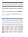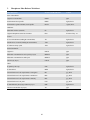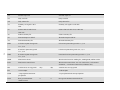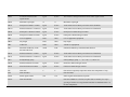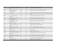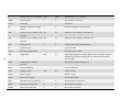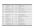
1
Environmental Policy Integrated Climate Model WinEPIC Interface Manual Ver. 0810 September 2013 Environmental Policy-Integrated Climate model (EPIC) and WinEPIC Blackland Research and Extension Center Texas A&M AgriLife 720 East Blackland Road Temple, Texas WinEPIC Development Team: Dr. Tom Gerik Co-project leader, quality control and beta testing Dr. Wyatte Harman Co-project leader, quality control and beta testing Dr. Jimmy Williams Larry Francis John Greiner Melanie Magre Avery Meinardus Evelyn Steglich Robin Taylor Author of EPIC Visual Basic programming Visual Basic programming Database maintenance, beta testing, guide development EPIC programming support Model validation, website maintenance, guide development WinEPIC 0810 Interface Manual revision i Disclaimer Warning: copyright law and international treaties protect this computer program. Unauthorized reproduction or distribution of this program, or any portion of it, may result in severe civil and criminal penalties and will be prosecuted to the full extent of the law. Information presented is based upon best estimates available at the time prepared. The Texas A&M University System makes no warranty, expressed or implied, or assumes any legal liability or responsibility for the accuracy, completeness or usefulness of any information. ii Model Objective: Assess the effect of soil erosion on productivity; Predict the effects of management decisions on soil, water, nutrient and pesticide movements; Predict the combined impact of changes to soil, water, and nutrient flux and pesticide fate on water quality and crop yields for areas with homogeneous soils and management. Model Operation: Daily time step. Long term simulations (1-4,000 years). Soil, weather, tillage and crop parameter data supplied with model. Soil profile can be divided into 3-15 layers. Choice of actual weather or weather generated from long term averages. Homogeneous areas up to large fields or small watersheds. Model Components: Weather Soil temperature Evapotranspiration Snow melt Surface runoff Return flow Percolation Lateral subsurface flow Water erosion Wind erosion Nitrogen leaching N & P loss in runoff Organic N & P transport by sediment N & P immobilization and uptake N & P mineralization Denitrification Mineral P cycling; N fixation Tillage practices Crop rotations Crop growth & yield for over 100 crops Plant environment control Fertilization Pesticide fate & transport Liming Drainage Irrigation Furrow diking Feed yards Lagoons Waste management Economic accounting iii EPIC Overview: The original function of EPIC was to estimate soil erosion by water under different crop and land management practices, a function reflected its original name: Erosion Productivity Impact Calculator. The development of the field-scale EPIC model was initiated in 1981 to support assessments of soil erosion impacts on soil productivity for soil, climate, and cropping practices representative of a broad spectrum of U.S. agricultural production regions. The first major application of EPIC was a national analysis performed in support of the 1985 Resources Conservation Act (RCA) assessment. The model has continuously evolved since that time and has been used in a wide range of field, regional, and national studies both in the U.S. and in other countries. The range of EPIC applications has also expanded greatly over that time including: Irrigation studies; Climate change effects on crop yields; Nutrient cycling and nutrient loss studies; Wind and water erosion studies; Soil carbon sequestration studies; Economic and environmental studies. EPIC is a process-based computer model that simulates the physico-chemical processes that occur in soil and water under agricultural management. It is designed to simulate a field, farm or small watershed that is homogenous with respect to climate, soil, landuse, and topography – termed a Hydrologic Landuse Unit (HLU). The area modeled may be of any size consistent with required HLU resolution. EPIC operates solely in time; there is no explicitly spatial component. Output from the model includes files giving the water, nutrient, and pesticide flux in the HLU at time scales from daily to annual. The growth of crop plants is simulated depending on the availability of nutrients and water and subject to ambient temperature and sunlight. The crop and land management methods used by growers can be simulated in considerable detail. The model can be subdivided into nine separate components defined as weather, hydrology, erosion, nutrients, soil temperature, plant growth, plant environment control, tillage, and economic budgets (Williams 1990). It is a field-scale model that is designed to simulate drainage areas that are characterized by homogeneous weather, soil, landscape, crop rotation, and management system parameters. It operates on a continuous basis using a daily time step and can perform long-term simulations for hundreds and even thousands of years. A wide range of crop rotations and other vegetative systems can be simulated with the generic crop growth routine used in EPIC. An extensive array of tillage systems and other management practices can also be simulated with the model. Seven options are provided to simulate water erosion and five options are available to simulate potential evapotranspiration (PET). Detailed discussions of the EPIC components and functions are given in Williams et al. (1984), Williams (1990), Sharply & Williams (1990), and Williams (1995). iv I. Introduction WinEPIC is a Windows® -compliant user-friendly interface for the EPIC (Environmental Policy Integrated Climate) crop simulation model (Williams et al. 1989). It combines many features of the CroPMan (Crop Production and Management) model (Gerik & Harman 2001). WinEPIC is designed to be a comprehensive user's simulation model for analyses of cultural practices and cropping systems on production, soil quality, water quality, water and wind erosion, and profits (Gerik et al. 2004). WinEPIC was developed with a focus on research applications in which multiple runs need to be made efficiently. This is in contrast to CroPMan in which single or a limited number of comparisons are executed and displayed using graphic displays for convenient interpretation by the user. The WinEPIC interface allows the user to: Provide minimal input data to run EPIC; Customize specific EPIC input variables. The following diagram shows the flow of information in WinEPIC: Definitions: EPIC Projects, Scenarios & Runs A project is a study designed to model and explore an idea or concept regarding the impact of agricultural management practice(s), geography (location and/or topography), or climate on crop yield, environmental impact, and/or economics of the agricultural enterprise. It will involve the manipulation of one or more variables (e.g. presence or absence of a management practice or constant versus increasing atmospheric CO2). Each model execution with a defined set of input data is a scenario. A scenario may be run standalone or as a member of a batch run. A scenario is therefore a single specific model 1 configuration within a project or study which will typically consist of one or more runs of one or more scenarios. The following examples illustrate the flexibility of EPIC to simulate the environmental impact of agriculture: An EPIC project may involve the same crop and land management scenario applied to several separate parcels of land (a field, farm, or small watershed), each with different soil and/or weather input in a series of runs; An EPIC project may involve a variety of management scenarios applied in a series of runs to the same parcel of land having the same soil and weather files; An EPIC project may be created for a virtual or real parcel of land subjected to the same scenario (management practices, soil, and weather kept constant), while the geographic characteristics (latitude, longitude, altitude, slope, or aspect) of the site are varied in a series of runs. 2 II. WinEPIC Main Menu On launching WinEPIC, the Main Menu screen presents the basic functions of WinEPIC. Three buttons and two menu items are used to setup, create and run one or more EPIC model runs: Create Runs, Run Batches, Data/Setup, Change Database & Change Units To exit the program, press the Exit button in the lower right corner of the window. All other windows have a Back button to bring you back to the previous screen and ultimately to this window. Create Runs is used to set up and save new sets of simulation criteria into a specific scenario. Run Batches allows the user to manage the saved scenarios and select scenario(s) to run. Data/Setup is used to select and specify parameters for a project. Change Database is used to select the user database for the current session. Change Units selects English or metric units for the model. 3 A. Data/Setup Data/Setup is used to tailor WinEPIC with specific information as to the location, to modify the user’s information including user IDs, farms, fields, zones, soils, cropping systems, weather, fertilizers and pesticides. Also, it can be used to modify control data, selected crop physiology characteristics, prices, and costs. Click Data/Setup on the Main Menu screen to access the Data/Setup screen: The buttons and menus in Data/Setup allow the following functions: Entry of information about User IDs and their farming units. Entry of information specific to the user’s geographic location (address, telephone number, latitude, longitude, etc.) Selection of soils, cropping systems, fertilizers, pesticides and other program parameters. Editing/adding control files and setting years of simulation. Editing of lime, fuel, labor, fertilizer and pesticide costs, grain and forage prices and machinery prices. Addition of custom cropping systems to the default set of cropping systems furnished with the program. Editing/adding crop budgets and equipment items. 1. UserID’s The purpose of the User ID database is to identify the location and other pertinent data associated with each WinEPIC project. The information entered here is used to label all input and output files. The User ID database will be reviewed as if the user were creating a new User ID rather than using the default User ID already present in the program. To begin managing the User ID database, select User ID’s on the Data/Setup screen and then click Add User ID to access the User ID Add screen. Stored users are obtained with the drop down menu Select a User ID: 4 There are two parts to this feature— User ID data and Run Unit data. The User ID database contains general information about each user, such as name, address, phone numbers, etc. Also included is information on the run units (farm, site, zone) used in a WinEPIC run. Consequently, all run units are linked to a specific User ID. There may be multiple records for a User ID Run Units, e.g. several farms and several fields and/or zones within each farm. Some of the database options discussed below will not appear until a name is selected from the drop down menu on the Add User ID screen. However, once the User ID name is selected, the user may proceed with additional options to maintain the User ID database. The User ID options include Add User ID, Edit User ID, and Delete User ID and the Run Unit options include Add a Run Unit and Edit a Run Unit. NOTE: Immediately after a new User ID has been added, the program will use it as the default User ID and the user may view this new User ID on the User ID Add screen. a. AddingaUserID Enter the general User ID information for a new User ID. The “last name” field is a required entry meaning a name must be entered to add a User ID. Each User ID must be unique; if the user enters a User ID’s “first name” and “last name” that already exist in the database, the user will be prompted to change the entry. After all of the User ID data are entered, click Save and either Yes or No to add additional User ID s. 5 b. EditingaUserID The user must click successive buttons to edit the User ID information: After selecting the User ID on the Add User ID screen, click Edit User ID. If the user makes changes to any of the fields or attempts any other operation including editing any of the run unit data, the user will be prompted to save these changes. Note: Editing the User ID information in no way changes the associated run unit information. To change the User ID for the associated run units, edit the User ID. DO NOT delete the User ID and add another one; this will cause all of the associated run unit information to be deleted. c. DeletingaUserID If Delete User ID is chosen, the user will be notified that if the current User ID is deleted, all of the User ID data (both input and output) and associated run units will be deleted. Each User ID is assigned a unique ID when first entered. This ID is used once and cannot be re-assigned. This ID is also saved with each of the respective owners’ run units; and therefore, will be used to delete the run units along with the associated User ID information if the user continues. After the initial User ID information has been added and saved, the WinEPIC program will automatically return to the Adding a User ID screen and load the User ID that was last added. If an alternative User ID exists, scroll to select another User ID to make additions or deletions. Until a new or existing User ID is selected, the database options will not appear. If desired, the user may Add a Run Unit and/or Edit a Run Unit in Run Unit Options, after the User ID has been selected. d. Addingarununit A run unit may be added by clicking Run Unit Options and then Add a Run Unit. This allows the user to add a new run unit or to make changes to any existing run unit, if applicable, and to save it as a new one. To add the first run unit, click “Unlock form to add new Run Unit” and simply fill the form with the necessary or required fields. To add successive run units or add additional run units by modifying an existing run unit, select the appropriate bullet, i.e. "Select a Run Unit to Modify” or “Unlock form to add new Run Unit”. After entering the data to create a new run unit or edit an existing run unit, click Site Data. Here, the user will establish the type of irrigation regimen used on the field (whether the irrigation 6 amount is fixed or flexible), the flexible irrigation interval time, and various other parameters. If the field is not irrigated, set the irrigation code to dryland and no irrigations will occur. Caution: If flexible irrigation is selected and the crop budget contains irrigation amounts also, they will be replaced with the flexible amounts needed to fill the soil profile on the exact days indicated for irrigation applications in the crop budget. After the site data has been set, click Back and Save to complete the operation. e. EditingorDeletingarununit Edit a Run Unit is the default mode of operation of this screen. If the user makes changes to any of the fields or attempts any other operation (including editing any of the User ID information), the user will be prompted to save these changes. To edit a run unit, click Edit a Run Unit, select the farm and field from the drop down menus, change the entries as desired and click Save. To delete a run unit, select the farm and site to delete and click Delete Run Unit. 7 2. CropData Selecting Crop Data on the Data/Setup screen is used to edit parameters by category for all of the crops included in WinEPIC. The user may enter a new value or reset the parameter to the default value. It should be noted that the seed cost and yield price can be revised in this section. 3. CroppingSystems Cropping systems are defined as unique combinations of the rotation (crop order), as well as the type, timing, rate and method for each operation associated with the rotation. Cropping systems may be defined for a single crop or up to 4 crops in a rotation. Cropping systems may be combined to create longer rotations. The user may either select or add cropping systems for the specific location by clicking Cropping Systems on the Data/Setup screen. Click Select cropping systems for this location to select one, many or all cropping systems from the entire list for use in the WinEPIC program. 8 Alternatively, by clicking Add a cropping system the user may create a new cropping system from various combinations of three components: irrigation method, tillage type and up to 4 crops. 4. .ControlTableEditor Control Table Editor on the Data/Setup screen is used to manage the control records. Within the control table editor, the starting year of the simulation, as well as the duration of the simulation are set. Automatic irrigation and fertilization parameters among numerous other control parameters are also set within the control table, including the auto irrigation trigger. In order to make scenarios using different years of simulation or irrigation strategies, several control tables must be created. The control table will 9 determine when and under what circumstances the scenarios will be run. Control Table Editor has three buttons: Add New Record, Add New Record Using Existing Record or Edit Record. Upon selection, the user may add or change the parameter values in the Current column. For convenience, the default value is listed in the Default column. a. AddNewControlRecord Click Add New Record to add a new control record and a new number will be assigned automatically as the record number. Type a name (up to eight-characters) in the Enter New Control Record field. The user may enter values in each of the cells in the Current column or click Set All to Default to automatically enter the default values for all of the parameters on the current page, i.e. if only a few of the parameters are different from the values in the default control file, this will quickly add the default values into the Current values column and those few parameters can be entered individually. Entries can be cancelled or saved by clicking the appropriate button. Upon saving the record, a message stating, “A New Record has been Added” will appear. The start date of the simulation in the control table must be identical to (or later than) the initial date of the weather history. Otherwise, all weather will be generated as a random process. Also, a start date past the date of weather history will initiate generated weather. For a weather history with varying dates like this, the user may consider setting up multiple control files containing exact beginning and ending dates to select from in Create Runs. b. AddNewRecordUsingExistingRecord Click Add New Record Using Existing Record to add a new control record based on an existing record. Existing records may be selected by clicking the drop down menus Select by Record Number or Select by Control Record. You will then be prompted to enter a new control record name. Make changes to the parameter values in the Current column (which is similar to the procedure above for adding a control record). Entries can be reset to their original values by clicking Set All to Default. Click Cancel Change(s) or Save Changes(s) to exit without saving or complete the process. NOTE: When creating a new run, the last control record saved will appear along with previous ones saved as different record numbers; otherwise, only one will appear for selection. All runs created with the last control record, and all runs previously created with other control records having the same record number as the last one, will use only one control record—the last one. Changing the name has no effect on the data being used in the control record—only the record number affects the data used. c. EditRecord Click Edit Record and select an existing record from the drop down menu to change an existing control record. Make changes to the parameter values in the Current column (which is similar to the procedure above for adding a control record). Entries can be reset to their original values by clicking Set All to Default. Click Cancel Change(s) or Save Changes(s) to exit without saving or complete the process. 10 d. KeyParametersforRevision The list below gives a description of some key parameters that need to be reviewed for each set of batch runs. Variable Description NBYR Number of simulated years. For crop rotations, make the year a multiple of the rotation period. IYRO, IMO, IDA See Add Control Record NGN Must be set to non-zero value if actual weather history is to be used. IET Must use an appropriate PET method for yield validation. ISTA Must set to 1.0 if no erosion is to occur (e.g. for short-term yield validation). IHUS Instructs the budget operation to occur when indicated GDUs (fraction of growing season GDU). NCOW Must be greater than 0 for forage to be grazed and forage yields to be reported. FL, FW Length and width of the field impacted by wind (wind run). STD Crop residue impacts wind and water erosion and it is only good for first day of simulation whether a pre-run year or a simulated year. Thus, if a level of residue is required to begin a simulation, then DO NOT perform any pre-run years. ACW If nutrient or pesticide losses are being analyzed, they will be unduly influenced by gross soils losses (as opposed to net soil losses due to soil replacement) by wind. In these situations, losses are difficult to estimate accurately though relative losses may be used in analysis with caution. BIR The irrigation trigger−this turns on automatic irrigation and if combined with flexible applications, budget dates and amounts are ignored. If combined with fixed applications, irrigations will be added to the scheduled applications as needed to meet the water conditions. 11 PEC This parameter is crucial for determining soil erosion. GZLM. This parameter is crucial to prevent erosion of a grazed crop DRV This parameter is crucial for choosing the water erosion equation. 5. EquipmentEditor Click Equipment/Activities on the Data/Setup screen to edit tillage and irrigation equipment information; for example, the user may indicate grazing quantity and manure deposited each day using this option. Select the activity category and then select the specific activity and equipment combination in the second drop down menu.. a. EditaTillageActivity Select Harvest and COMBINE, 2 WD for example and click Edit to select the combination of machinery/equipment for editing. Select the particular activity to modify and type the new values in the New column. After all changes are complete, click Save, then Save Edited Op. And Exit. Back will cancel edits. In the case of irrigation systems with efficiencies indicated in their titles, the percentage runoff and percentage distribution efficiency cannot be changed. If, after reviewing the various systems, a center pivot system does not exist with the correct combination of runoff and distribution efficiency, there is a center pivot system with no efficiency in its title for customizing percentage runoff and percentage distribution efficiency. 12 b. AddaTillageActivity To add a tillage activity select the activity category and specific activity Click Add New to modify an existing activity. Type the new activity name in the title box and an 8 character abbreviation, then click Continue. Enter changes in the New column, click Save, and Save Edited Op. And Exit. Back will cancel edits. 13 c. SpecializedCategories The Equipment Editor has some specialized categories in the following sections: Grazing Using grazing as an enterprise, the amount of dry forage grazed is set in ORHI - Override Harvest Index as (kg/head/day). This value must be equal to or greater than 1.0 in the Graze Start activity. Otherwise, it will be read as a Harvest Index for a forage harvester, the amount of biomass above ground harvested. In order for grazing to occur, it is essential that NCOW be greater than zero in the Control Record. When the Grazing Limit (GZLM) or the above ground plant material (T/ha) is met, grazing stops until the crop grows above GZLM. This is to keep from over grazing and killing the crop. Graze Stop is an activity that is required in the management activities to stop grazing, facilitating multiple grazing periods within or across years. The custom hire is the cost of the custom operation or in the case of grazing, the price of operating costs for fencing, care, medicine, etc. NOTE: Crop grazing income is not included in this version. The researcher must add crop-grazing income and subtract additional costs to calculate grazing profits to be added to crop profits. PlasticCover To use plastic cover to control or minimize weeds and evaporation, revise the “fraction soil surface covered” to a fractional estimate. Random surface roughness impacts wind erosion and can be set near 0 if nearly the entire soil surface is covered with plastic. There is also a special equipment item typically used for rice flood irrigation: puddle rice paddy which causes layer 2 of soil profile to reduce infiltration significantly. To return soil to normal condition, include Puddle Stop as an operation. 14 6. ManagementEditor Click Management on the Data/Setup screen to create or edit existing budgets. a. EditExistingBudget To edit an existing budget by modifying, click Edit Existing Budget on the Edit or Add Budget screen and select the crop budget to edit from the drop down menu. The operations for the selected budget will be displayed in the Data/Setup-Edit Budgets screen. To edit an existing operation type, amount of application, etc., the user may enter data directly by selecting any cell in the datasheet and then making the desired changes with the drop down menus below the datasheet to the desired fields. Similarly, new operations may be added to the datasheet by clicking Add Operation . 15 For example, in the above corn budget, the user may want to change the amount of fertilizer applied on a particular date. The user would use the lower horizontal scroll bar to scroll over to the right side of the budget to the fertilizer rate column and click on line to change in the “Rate” data box This action generates the appropriate menus below the budget to change and save the information. In this example, the screen below the budget has a box for the new fertilizer value. After making selections, the user may Save, Cancel or Delete Row: click the Save button to save changes or Cancel to cancel changes to the fertilizer rate. The entire row of the budget may be deleted by clicking Delete Row. To have changes revert back to the default values, simply click Set Budget to Default. The bottom of the screen has a box with the variable definition and/or range of values permitted for the selected operation or parameter. Caution: DO NOT set the amount of fertilizer rate applied to zero. This activates an automatic fertilizer option wherein fertilizer is applied according to pre-specified nitrogen stress of lack of N. NOTE: When modifying or adding operations, the date of operation is critical, especially for those using the yield for calculating costs. In the case of drying, hauling, ginning and bagging & ties, the date of these operations must be after HARVEST and before KILL for the cost calculations to be correct. In the case of dual inputs such as putting on a starter fertilizer with the planter, simply add the fertilizer on the same day as planting with a "Fertilizer application, attached to implement" with the kind, amount, and depth of fertilizer placement, but do not add a tractor. In similar fashion, dual or triple pesticide mixes can be applied at the same time, or two machines can be pulled by one tractor. Omitting the tractor for the 2nd, 3rd, up to the nth operations on the same day avoids double counting tractor fuel, repairs, and labor costs. Also, using equipment items that are "attached to implement" prevents double counting of machinery depreciation and interest on investment costs. In the event of an operation such as spot spraying in which there is no specific machine or tractor used, select the "no cost operation" and include the kind and estimated amount of input per land unit, i.e. Roundup Ultra, 0.01 gal/ac. Note: The user may alter other fields, in a similar manner as in the example above, using the table entry method to move across the data sheet or table to enter changes. To view the entire budget, the user may move through the datasheet by using the up/down and right/left scroll arrows . 16 To edit an existing budget by adding a new operation, click Add Operation on the Data/Setup-Edit Budgets screen and select the type of operation to add from the drop down menu provided. For example, a new fertilizer may be added to an existing budget by selecting “Fertilize” from the drop down menu. This action generates the appropriate menus beneath the budget. After entries are completed, click Save Operation. Similarly, to add a new irrigation from the Data/Setup-Edit Budgets screen, click Add Operation, select “Irrigate” from the drop down menu provided make the appropriate selections and Save Operation. Several sprinkler systems of various application efficiencies can be selected but the furrow (row) irrigation application efficiency with gated pipe is set at 75% of which 20% is runoff loss and 5% is distribution loss. To revise this and other irrigation system efficiencies, the user may edit the appropriate irrigation system in Equipment/Activities on the Data/Setup screen. 17 The user may at any time click the Set Budget to Default to cancel all changes to the budget and reset the budget values back to the original default budget values for all operations. After all of the operations have been changed or added, click Save to save the new information in the datasheet. Click Back to exit the budget. The user will either click Yes to save all changes to the budget before exiting or No. b. Add1to4AnnualCrop(s) From the Edit or Add Budget screen, click 1 to 4 Annual Crop(s) on the Edit or Add Budget screen to make a budget for one to four crops per year. Select the number of crops to add and click Continue. Adding more than one crop assumes these crops are successive crops or are intercropped as opposed to double cropped which is restricted to two successive crops. Fill in the required fields: enter a new budget ID to the new budget, identify the type of tillage and irrigation regimen, select the crop(s), and enter a new crop name and crop ID for each of the crops. NOTE: The new budget ID is limited to 10 alphanumeric characters. Click Continue and the budget operations for the new selections are displayed in the Data/Setup-Edit Budgets screen Essentially, this creates a new budget and it is treated from this point as an existing budget, i.e. the user may make other additions or changes to an existing budget in the same manner used above to Edit Existing Budgets. A warning message appears prompting the user to check the dates of operations or sequencing of operations so as to prevent errors from occurring. New operations are added by clicking Add Operation, which brings up and edit screen 18 c. AddaDoubleAnnualCropBudget To add a new budget with a double annual crop, click 1 to 4 Annual Crop(s) on the Edit or Add Budget screen and select 2 crops in the drop down menu from the Edit or Add Budget screen. Fill in the required fields: assign a new budget ID to the new budget, identify the type of tillage and determine whether dryland or some other type of irrigation system will be used. Select the first cropping system that will act as a starting point for the first crop in the new budget. Enter the second crop in the same manner as the first. Clicking Continue leads to the Edit Budget screen where the budget templates may be modified and operations added. Editing is as described above 19 d. AddaMonowithAnnualCoverCropBudget To add a new single crop budget with an annual cover crop, click 1 to 4 Annual Crop(s) on the Edit or Add Budget screen and fill in the required fields: assign a new budget ID to the new budget, identify the type of tillage and define what type of irrigation will be used. Select the cover cropping system that will act as a starting point for the new budget. The user may either use a crop already present in the database or create a new crop by clicking Make New Crop and fill in the new crop name and crop ID. Select the second crop in the same manner as the first. Click Continue and the budget operations for the new selections are displayed in the Data/Setup-Edit Budgets screen since the budget just added is now treated as an existing budget which may be edited. 20 e. Add1to4PerennialCropsBudget To add one to four perennial crop budgets for up to 50 years, click Add 1 to 4 Crops (Perennial) on the Edit or Add Budget screen. Select the number of crops and the number of years in the budget. Fill in the required fields: assign a new budget ID number to the new budget, identify the type of tillage and determine whether dryland or some type of irrigation system will be used. Select the first crop that will act as a starting point for the new budget. The user may either use the crop already present in the database or create a new crop by checking the “Make a New Crop” box and filling in the new crop name and crop ID. The user may choose “Select Crop To Use As Template” and then select the proxy crop in the same manner as the first. If the user wants the same crop in subsequent years, and wants to automatically add operations for the remaining years, he/she will be able to add operations, which will occur on a yearly basis, with this single action and the program will automatically add the operations every year of the budget. This will save time from having to enter the repetitious operations one by one. Click Continue and if no proxy template is selected, answer yes or no. If yes, a budget screen appears to build year 1 to be used as a repetitive process for years 2, 3…n. If no, a generic budget including only a plant operation will appear to be used for years 2, 3…n to this planting operation. The user will only need to add operations that are repeated. A harvest operation is required to get yields. The number of years in a perennial crop budget in SETUP must be equal to or an exact multiple of the number of years being simulated in the CONTROL TABLE. If less, and the crop is harvested in the last year only, no yield will be reported in the CROP SUMMARY or CROP YEARLY output ACCESS tables. Additionally, if the simulated years are longer than in the perennial crop budget, yields will be reported for the first rotation of crop years but not necessarily for all of the years of the 2nd, 3rd, or nth rotations if the simulated years are not an exact multiple of the budget years in SETUP. 21 By selecting one year more than the template budget, a screen will display year 1 operations of the template to allow major modifications, which are to be repetitive each year in the new crop budget. Make the necessary changes here and they will be repeated in all years after clicking Continue. Because the wrong number of years was originally selected, several operations at the end may need to be deleted to restore the correct number of years to the rotation (change the final year of the kill but do not delete it). When editing the final budget for repetitive operations with the same name, select the operation and hit the “Enter” button to register the change then click Change All. For irrigation and fertilizer amounts, select the amount and type in the correct amount in the box and hit the “Enter” button to register the change, then click Change All. A message will appear requesting if the new amount is to replace all of the entries with the old amount. If so, click Yes. Click Continue and OK to warning of checking dates on each operation. The budget operations for the new selections are displayed in the Data/Setup-Edit Budgets screen since the budget just added is now 22 treated as an existing budget that may be edited. NOTE: A perennial hay crop (e.g. alfalfa) will be harvested at the specified GDU fraction(s) of the growing season each year if and only if it is planted in YEAR 0 and harvested thereafter in years 0 or 1at one or more GDUs. If it is planted in year 1 and harvested in year 2, it will be planted every other year and harvested every other year at the specified GDUs. If a perennial hay crop is NOT to be harvested, create a new perennial crop budget of the same crop. However, in the new crop budget DELETE all harvest operations. This will cause the crop to grow until the end of the period, e.g. 20 years, without being harvested anytime. In perennial cropping systems, harvest(s) will occur every year for the number of years simulated (indicated in the control table) if planted in year 1 despite the number of years in the crop budget. If a fall-seeded perennial is to be reseeded after the last harvest, change all operations in year 0 to year 1. Then, move the kill operation to follow harvest in year1, but it must precede planting. Otherwise, if it is not to be reseeded after harvest, delete all operations in year 1 and change operations in year 0 to year 1. If a fall-seeded perennial is put into a rotation with an annual crop, make a seeded perennial template seed in year 0 instead of year 1 by: 1) Develop a fake perennial budget called “ZZZZ” though the normal process of making a single crop, perennial for N years. This process will automatically renumber the fall seeding year to 0 if the correct number of years in the template rotation are selected, i.e. if the template is for 3 years (years 1-3), selecting 2 years will renumber it 0-2 years. 2) Develop the new perennial budget named the desired name, using the appropriate crop, and using “ZZZZ” as the template budget. The new fall-seeded budget will then be numbered 0,1,2...n. 3) When making the rotation in Cropping Systems, always select the annual crop first followed by the new perennial crop numbered 0,1,2…n. This facilitates planting the perennial after the annual crop and harvesting both in sequential years. To exit the Data/Setup-Edit Budgets screens, the user must click Back through several screens until the Data/Setup screen reappears. 7. Fertilizers Fertilizers on the Data/Setup screen is used to edit or select fertilizers for use in WinEPIC. To select/deselect specific fertilizer products to be used, click Select Fertilizers for this location and select fertilizers (or deselect certain unnecessary fertilizer products) from the list provided. To modify any of the specific fertilizer products, click Edit Selected Fertilizers, choose specific fertilizer to edit from the drop down 23 menu and make the desired changes. The user can modify any prices of the existing fertilizers. Fertilizer price data listed under the "Current" column may be changed by entry of new data under the "New" column. Cancel and Save appear when a change is entered in the "New" column. Note: The gray fields may not be altered. 8. Pesticides Pesticides on the Data/Setup screen is used to edit or select pesticides for use and to turn pesticide fate and transport on by checking the box in WinEPIC. To select/deselect specific pesticide products to be used, click Select Pesticide products for this location and select pesticides (or deselect certain unnecessary pesticide products) from the list provided. To modify any of the specific pesticide products, 24 click Edit Selected Pesticides, choose specific pesticide to edit from the drop down menu and make the desired changes. The user can modify any prices of the existing pesticides. Pesticide price data listed under the "Current " column may be changed by entry of new data under the "New " column. Cancel and Save appear when a change is entered in the "New" column. Note: The gray fields may not be altered. 9. Weather By clicking WEATHER on the Data/Setup screen, the user may select or edit weather stations for use in WinEPIC. Weather stations are selected using the drop down menu Choose a Weather Station to edit. To modify values for the chosen weather station, enter them in the New columns – one per month. Once a value has been entered, Cancel and Save buttons appear. After changes have been made and saved, the original values can be reinstated by clicking Defaults. 25 10. GeneralCosts By clicking General Costs on the Data/Setup screen appears. The default parameters are listed in the Current column for irrigation pumping cost, lime cost, fuel cost, labor cost and additional costs. These default parameters may be changed by clicking on the appropriate box under the New column. Once a change is made, the user is given the option to Cancel or Save changes. 11. Location Location contains name, address, latitude, longitude and other miscellaneous data about the location or database. The latitude and longitude define the boundaries of the database. 26 Maximum and minimum latitude and longitude are used for error checking when the latitude and longitude for individual run units (fields, farms, and small watersheds) are entered. If the run unit does not fall within the bounds specified under Data/Setup/Location, the user is warned as the run unit data is entered. 12. Soils Soils for a specific county can be added, selected or modified by clicking Soils on the Data/Setup screen. By first selecting a specific county, the user may then select soils for editing or use: Edit selected soils for XXX county or Select soils for XXX county. To edit soils, use the drop down menu Select Soils and enter new values in the New column and when all edits are completed click Save Changes. To cancel click Cancel Changes or to return to default values, click Set all fields to Default. Water table data may be changed by clicking Edit Water Table Variables. New records may be entered in the database by clicking Add User Define Soil and entering data into a header window. Accepting the these data will bring up an edit window for the new soil. Values from the soil used as a template will be entered in the Current column; enter new values into the New column. Click Save Changes to enter the new record into the database. 27 To select/deselect specific soils to be used in a scenario, click Select soils for XXX county. A new soil can be added by selecting a soil as described above and clicking Add next to the soil drop down menu on the Editing a Soil Screen. The user can rename the soil (30 character limit) and make any changes to the soil characteristics. To save the new soil, click Save. The program will return to the Editing a Soil Screen. The new soil can be edited as described previously. 28 B. CreateRuns This feature allows the user to make a new input dataset and run WinEPIC. Selections for User ID, site, name, location (county), land condition, soil, weather station, cropping system and control file are made from drop down menus. The interface uses these choices to build an input file for the WinEPIC program and the model to run. Specifying the soils, cropping system and climate conditions were discussed previously in Data/Setup. Specification of the land condition facilitates identification of hydrologic characteristics including infiltration and runoff as affected by straight row planting, contour planting or contour planting combined with terraces. These conditions when considered along with the soil hydrologic group determine the NRCS curve number (see APPENDIX A – NRCS Curve Numbers). From this screen, the user can access specific User IDs, the associated farm names, site names and locations. Then by specifying the soil, weather, cropping system, land condition and control file, runs can be made for this User ID. 1. CreateWinEPICRun From the Main Menu screen, click Create Runs to start a new input dataset When this screen is first accessed, Save WinEPICV3 Run will be dimmed indicating that it is not active or is disabled. It will not become active until all the selections necessary (required green fields) for a WinEPICV3 Run have been made. Use the selection boxes to choose a User ID, farm, site, location, soil, land condition, weather station, cropping system and control record. Note: Selections in Data/Setup for one or more User IDs, farms, sites and locations must have been made previously. The message at the bottom indicates the actual weather history of the selected weather station. Warning: The selected Control Table must indicate the same (or a later) starting date as in the weather history if actual weather is to be simulated. Otherwise, weather will be simulated if the start date is before or after the actual weather history. 29 For convenience, the user may select Clear All Fields to clear all the selections that have been made in this screen and begin again. In addition, the user may Switch to Field entry mode or Switch to User Id entry mode to enter selections. After all required selections for one run (orange data fields in Field Entry Mode and green data fields in User ID Entry Mode) are completed and entries are made on the Create Runs screen, the user may click Save WinEPICV3 Run. Successive runs may be saved from this screen. At this point, the saved runs have not actually been run; therefore, no output will be available until the batch has been run though Run Batches. 2. SaveWinEPICRun When all sections of the Create Runs screen have been filled in with appropriate entries, Save WinEPIC Run will become active or enabled. Click Save WinEPIC Run and a blinking message box will be displayed stating that the Run is Saved. Continue creating runs by making changes to the selections at will and click Save WinEPICV3 Run for each run. For convenience, click the Clear button to clear all selections and start with a blank screen before creating new runs. When all of the desired runs have been created, click Back to return to the Main Menu screen. 30 C. RunBatches Click Run Batches on the Main Menu screen to begin selecting the runs to include in the groups or batches of runs. 1. SelectRunBatches To select runs to form a “Batch of Runs”, the user may select all of the saved runs ortherunsmeeting specificselectioncriteriaontheRunBatchesSelectionscreen . The criteria include cropping system, soil, county, weather station, User ID, farm, site, and zone. One or more criteria may be used to select runs. Here, the list includes all saved runs listed by soil from which the user may select. Check the box next to each type of criteria the user desires to use in selecting the Batch of Runs and then select the individual runs. At this time, the user may want to clear all previous output results by clicking Clear All Output Tables in WinEpic.mdb. To first review the contents of the output database click Open Output Database (WinEpic.mdb). This allows the user access to the file without having to exit the program. 31 For more information, see section IV.A. After all selections are made, click Continue to proceed. 2. OptionsforRunSelection(s) After the Run Batches have been selected, the user may refine the list by checking runs in the list with the mouse and/or clicking Clear Selected, Select All, Expand List or Trim List (to view only the selected runs in the batch). Other options include Delete Selected Runs and the pre-run options (to make a simulation run for 12 years before the onset of the actual run), number of years of the run, the number of years in cultivation and the beginning year of the pre-run. Output from the pre-run will not be displayed in the WinEPIC output database. Performing a prerun allows for the soil properties to be adjusted by the local climate and cropping practices. It is suggested that 12 years be pre-run prior to the initial years of simulation if the rotation is one of 2, 3, or 4 crops, providing adequate weather data precedes the initial year. 3. OutputSelection Select Change Output Files and check the output tables of interest. WARNING: Do not select output with daily results unless they are specifically needed because the volume of data generated is quite large and are stored together in the same output file. If the simulation is run for too many years, the daily files may be too large for Access to accommodate and output will be unpredictable. 32 4. RunEPIC After all selections are made, click Continue. The runs within the batch run will be made. After all runs are completed, the Run Batches Selection Screen Options for Run Selection(s) will reappear. At this point the output can be viewed in the WinEPIC database. For more detail see section IV. All results are in metric units in the ACCESS WinEPIC.mdb file, despite the input being entered in English units. After selections are complete, the user may click Run WinEPIC. This produces an Output Selection screen. 33 D. Viewingand/orAnalyzingtheOutput The output generated by WinEPIC is written to a Microsoft Access database in the cpm0320V2 folder with filename WinEPIC.mdb. This file can be easily managed in a number of ways: 1. OpenorViewOutputusingtheACCESS Click Open Output Database (WinEpic.mdb) to examine output from the EPIC run and manage the data. All output tables are listed using nomenclature similar to that used below in the ACCESS Tables window. Tables that were not selected by the user on the Output Selection screen will have zero (0) in all fields. Variable definitions are also listed in APPENDIXD–WinEPICVariableDefinitions. 34 The user may save separate runs by renaming the WinEPIC.mdb file before it is cleared each time the program is run and use the output from these runs outside the WinEPIC program. The user would use the standard procedure with the Windows file manager to copy the output file to another file using copy and paste and then renaming the file (save as another file). The WinEPIC.mdb file is found in the cpm0320V2 parent directory. After a file is renamed, the user must use Windows Explorer and Microsoft Access to open, edit or delete the file. If the file is not renamed or cleared, all the data from each successive run is placed into the same file: WinEPIC.mdb. Depending on the type of output the table contains, the user may subset this dataset further by selecting only specific fields, runs, crops, soil layers, years, months and/or days with the buttons to the right of the run and table drop down menus. Once selected, the information within may be used to again subset the data from a larger set of output and then added to a spreadsheet to minimize the amount of data the user must handle. Query Wizard and Query Design functions in ACCESS can be used to examine output that satisfies conditions; queries may be for a single table or may include several tables. Alternatively, ACCESS table may be exported as Excel tables for analysis and graphical representation. From Excel, tables can be imported into most statistical packages (e.g. SAS, Statistica, Systat, etc.) for more detailed analysis 35 III. Installation and Support 1. HardwareRequirements A personal computer running WindowsX® or Windows7® with a minimum of 1 gigabytes of RAM and 1 gigabytes of free hard disk space is required to run the WinEPIC program. Improved performance will be obtained with 4 gigabytes of RAM and additional free hard disk space. 2. SoftwareRequirements Basic knowledge and use of Microsoft ACCESS is the software needed to manage database files. 3. Installation i. Download the WinEPIC installation package from http://epicapex.tamu.edu/downloads/ and documentation from http://epicapex.tamu.edu/downloads/user-manuals/ . ii. Save the install file to a directory and unzip it. iii. Double click setup.exeand follow the install instructions. A shortcut will be placed on your desktop: iv. When the installation is finished, double click the WinEPIC shortcut and click Data/Setup from the Main Menu screen to start. 3. Reinstall/Update If the user wishes to save established databases for a User ID(s) and location(s), do not reinstall or update the WinEPIC without first moving your databases as they will be overwritten by the installation process. 4. TechnicalSupport Technical support is available by emailing us at [email protected] 36 IV. References Gerik T & Harman WL. (2001) CroPMan User's Guide: Version 3.1. Blackland Research and Extension Center, Temple, Texas, pp. 101. Gerik TJ, Harman WL, Williams JR, Francis L, Greiner J, Magre M, Meinardus A & Steglich E. (2003) User’s Guide: CroPMan (Crop Production and Management) model, version 3.2. Blackland Research and Extension Center, Temple, Texas, pp.150. Sharpley AN & Williams JR (Eds.). (1990) EPIC – erosion/productivity impact calculator: 1. model documentation. USSDA Tech. Bull. 1768. Washington DC. Williams JR. (1990) The erosion productivity impact calculator (EPIC) model: A case history. Phil. Trans. R. Soc. Lond. 329:421-428. Williams JR. (1995) The EPIC Model. Pp. 909-1000 in Computer Models of Watershed Hydrology (Ed. Singh VP). Water Resources Publications, Highlands Ranch, CO. Williams JR, Jones CA & Dyke PT. (1984) A modeling approach to determining the relationship between erosion and soil productivity. Trans. ASAE 27:129-144. Williams JR, Jones CA, Kiniry JR & Spanel DA. (1989) The EPIC crop growth model. Trans ASAE 32(2): 497-511. 37 V. Appendices APPENDIXA: Runoffcurvenumbersforhydrologicsoil‐covercomplexes Land use Cover Treatment or practice Hydrologic condition Hydrologic soil group A B C ‐‐‐‐ Poor Good Poor Good Poor " Good Poor Good Poor Good Poor Good Poor Good Poor Good Poor Good 77 72 67 70 65 66 62 65 63 63 61 61 59 66 58 64 55 63 51 86 81 78 79 75 74 71 76 75 74 73 72 70 77 72 75 69 73 67 91 88 85 84 82 80 78 84 83 82 81 79 78 85 81 83 78 80 76 Poor Fair Good Poor Fair Good Good 68 49 39 47 25 6 30 79 69 61 67 59 35 58 Poor Woods are grazed by not burned, some litter covers soil Fair Woods are not grazed, litter & brush cover soil Good Farmsteads ‐‐‐‐ Roads (dirt)2 ‐‐‐‐ 2 (hard surface) ‐‐‐‐ Sugarcane Bermuda grass Impervious (Pavement, urban area) ‐‐‐‐ 45 36 25 59 72 74 39 49 98 66 60 55 74 82 84 61 69 98 Fallow Straight row Row crops Straight row " " Contoured " " Contoured & terraced " " Small grain Straight row " " Contoured " " Contoured & terraced " " Close‐seeded Straight row Legumes1 or " " rotation meadow Contoured " " Contoured & terraced " " Pasture or range <50% groundcover or heavily grazed 50‐75% ground cover & not heavily grazed >75% ground cover & lightly grazed Above characteristics & Contoured " " " " Meadow (continuous grass, not grazed and generally mowed for hay) Woods Small trees and brush (heavy grazing & regular burning D Land Use Number 86 79 74 81 75 70 71 94 91 89 88 86 82 81 88 87 85 84 82 81 89 85 85 83 83 80 89 84 80 88 83 79 78 1 2 3 4 5 6 7 8 9 10 11 12 13 14 15 16 17 18 19 20 21 22 23 24 25 26 77 73 70 82 87 90 74 79 98 83 79 77 86 89 92 80 84 98 27 28 29 30 31 32 33 34 35 1 Close-drilled or broadcast. 2 Including right of way. Taken from the National Engineering Handbook (U.S. Department of Agriculture, Soil Conservation Service 1972). 38 APPENDIXB: InputDatabases The database(s) provided with the WinEPIC program includes actual soils and weather station data for each region or location. These data include all county soils and weather data for each region or location within WinEPIC. Note: The CONTROL TABLE beginning year, month, and day must agree with the same variables of the actual weather, ******.dly, file. a. Location Location is the defined area used in a WinEPIC run that may be an entire state or a subset of counties forming a region. b. Climate Table 1: Sample Daily Weather Input for WinEPIC Year Month Date SRAD MaxT MinT Precip RH Wind 1991 10 1 18 29 19 0 0.72 0 1991 10 2 16 29 20 0 0.81 0 1991 10 3 17 30 19 0 0.72 0 1991 10 4 18 32 18 0 0.62 0 1991 10 5 13 33 18 0 0.48 0 1991 10 6 12 22 19 0 0.58 0 1991 10 7 7 23 16 0 0.63 0 1991 10 8 9 25 20 0 0.66 0 1991 10 9 9 26 18 0 0.42 0 1991 10 10 11 27 20 0 0.52 0 1991 10 11 14 32 18 0 0.76 0 1991 10 12 17 35 18 0 0.56 0 1991 10 13 18 34 18 0 0.73 0 1991 10 14 16 35 19 0 0.80 0 1991 10 15 11 29 18 0 0.60 0 1991 10 16 9 29 18 0 0.44 0 1991 10 17 12 28 18 0 0.63 0 1991 10 18 13 31 18 0 0.34 0 1991 10 19 13 30 19 0 0.56 0 1991 10 20 14 27 19 0 0.52 0 1991 10 21 11 27 19 0 0.33 0 1991 10 22 12 27 19 0 0.57 0 1991 10 23 19 30 19 0 0.58 0 39 1991 10 24 22 31 19 0 0.58 0 1991 10 25 22 33 19 0 0.63 0 1991 10 26 21 29 8 0.1 0.86 0 1991 10 27 17 28 10 2 0.93 0 Using the WXPARM tool, a file with the extension .lis was created for each site that met the necessary criteria. The *.lis file contains average monthly statistical parameters for such variables as maximum temperatures, minimum temperatures, solar radiation, precipitation and relative humidity. Using the town and city list, the Climate Data database was queried for sites with approximately 30 years of continuous daily temperature and precipitation data. For each of the towns and cities located, the following steps are performed individually. The closest existing location in the WXPARM database of numerous locations with existing long-term weather statistical parameters is located, then the temperature and precipitation data is read in. Next, using the WXGEN weather generator tool, the existing daily parameters are processed to produce a daily file in WinEPIC format that carries the maximum temperature (°C), minimum temperature (°C), solar radiation (MJ/m2), precipitation (mm), relative humidity (%) and wind speed (m/s). Table 3: Sample Average Monthly Weather Statistics for WinEPIC Input Month 1 2 3 4 5 6 7 8 9 10 11 12 Tmax 15 18 22 26 29 33 35 35 32 27 21 17 C Tmin 3.9 5.9 9.9 15 19 22 23 23 21 15 9.5 5.4 C 7 6.8 5.6 4 3.3 3 2 3 3.8 5 5.8 6.3 C Sd min 5.6 5.3 5.3 5 3.3 2 1 2 3.3 5 5.6 5.6 C Rain 48 60 47 72 115 94 52 53 86 98 58 58 mm Sd Rain 12 13 9.5 15 20 20 19 17 17 20 14 14 mm Skew Rain 4.9 2.7 2.7 2.0 2.8 3.0 4.0 3.0 2.9 3.0 3.8 3.3 P[w-d] 0.2 0.2 0.2 0 0.2 0 0 0 0.2 0 0.2 0.1 fraction P[w-w] 0.4 0.4 0.3 0 0.4 0 0 0 0.4 0 0.4 0.5 fraction Days Rain 6.6 6.4 6.1 7 8.1 6 5 5 7.2 6 6.3 6.5 number Solar Rad 11 13 16 17 21 25 26 23 19 16 12 10 MJ/m Rel Hum 0.7 0.8 0.7 1 0.8 1 1 1 0.7 1 0.7 0.7 fraction Wind Speed 0 0 0 0 0 0 0 0 0 0 0 0 m/s Sd Wspeed 0 0 0 0 0 0 0 0 0 0 0 0 m/s Skew Wspeed 0 0 0 0 0 0 0 0 0 0 0 0 Sd Tmax 40 2 c. Soils The soils database used to run WinEPIC is the Soils-5 database that was created and is maintained by the USDA-NRCS. The data were extracted using the Map Unit Use File (MUUF) program written by Otto Baumer, Paul Kenyon and Jeremy Bettis. The source code was modified by Nancy Sammons (USDAARS Temple, TX) to produce an ASCII file to be loaded into a Microsoft ACCESS database. These data are then used by the WinEPIC-LINK program to write the correct soil properties and the soil layer information in the WinEPIC dataset. Table 2: Soil Variables Required by WinEPIC: Acronym Full Name Units S5NUM Soils 5 number S5NAME Soils 5 name TEXTID Texture ID HYDGRP Hydrologic group LAYERNUM Soil layer number SALB Soil albedo Z Depth (bottom of layer) meters BD Bulk Density tons/meter U Wilting Point meter/meter FC Field Capacity meter/meter SAN Sand Content % SIL Silt Content % WN Organic Nitrogen-N Concentration grams/ton PH Soil pH SMB Sum of the bases cmol/kilogram CBN Organic carbon % CAC Calcium carbonate % CEC Cation exchange capacity cmol/kilogram ROK Rock % by volume WNO Nitrate Concentration grams/ton AP Labile phosphorus concentration grams/ton RSD Crop residue tons/hectare BDD Oven dry bulk density tons/meter3 PSP Phosphorus sorption ratio SC Saturated conductivity mm/hour WP Organic phosphorus concentration grams/ton 41 d. Rotations For each county of interest, a collection of the most common crop rotations was made using the 1992 Natural Resource Inventory (NRI). The National Resource Inventory (NRI) database is accurate at state level for all states and to county level for Oklahoma, Kansas, Texas, Illinois, Idaho, South Dakota and Minnesota. For crop rotations only, use 1989, 1990, 1991 and 1992 for data and codes 180 or less (181+ is forest, road or other land not crops). The Product design team has broken down the NRI data by state. Each site location receives only data for its own state rotation for now, not the surrounding states. e. Crops Crops included in WinEPIC's default data were selected to meet the needs of the Agricultural Sector Model (ASM). Crops were selected for use in the ASM by identifying the crops listed by state in the U.S. Department of Agriculture, National Agricultural Statistics Service's (NASS) annual publication, Agricultural Statistics. A 20-year period, for example 1973-1993, was used to identify alternative crops that had been produced in that state. Table 3 : List of Crops available for use in WinEPIC: Common name Scientific name Common name Scientific name Alfalfa Medicago sativa Wild Rye Leymus angustus Annual Rye Grass Lolium multiflorum Asparagus Brassica oleracea Barley Hordeum vulgare Big Bluestem Andropogon gerardii Broccoli Brassica oleracea Brome Grass Bromus inermis Buffalo Grass Buchloe dactylodes Cabbage Brassica oleracea Canadian Barley Hordeum vulgare Canadian Oats Avena sativa Canadian Spring Wheat Triticum aestivum Canola Brassica napus Cantaloupe Cucumis melo Carrots Daucus carota sativus Cauliflower Brassica oleracea Celery Brassica rapa Cheatgrass (Downy Brome) Bromus tectorum Clover Alsike Trifolium hybridum Coastal Bermuda Cynodon dactylon Corn Zea mays Corn Silage Zea mays. Cucumbers Cucumis sativus Dry Beans Phaseolus vulgaris Durum Wheat Triticum turgidum Eggplant Solanum melongena Faba Beans Vica faba Fallow Fescue Festuca spp. Field Peas Pisum sativum Flax Linum spp. Grain Sorghum Sorghum bicolor Green Beans Phaseolus vulgaris Foxtail (Green/Yellow) Setaria glauca Honeydew Melon Cucumis melo Johnson Grass Sorghum halapense Leaf Lettuce Latuca sativa Lentils Lens culinaris Lettuce Latuca sativa Lima Beans Phaesolus limensis 42 Oats Avena sativa Onions Allium cepa Peanuts Arachis hypogaea Pearl Millet Pennisetum americanum Peas Pisum sativum Peppers Capsicum annuum Picker Cotton Gossypium hirsutum Potato Solanum tuberosum Range Red clover Trifolium pretense Rice Oryza sativa Russian Wild Rye Psathyrostachys juncea Rye Secale cerale Sideoats Grama Bouteloua crutipendula Sorghum Hay Sorghum bicolor Soybeans Glycine max Spinach Spinacia oleracea Spring wheat Triticum aestivum Strawberries Fragaria spp. Stripper Cotton Gossypium hirsutum Sugarbeets Beta vulgaris Sugarcane Saccharum spp. Summer Pasture Sunflowers Helianthus spp. Sweet Clover Melilotus spp. Sweet Corn Zea mays Sweet Potatoes Ipomea batatas Timothy Phleum pratense Tomato Lycopersicon spp. Watermelon Citrullus lanatus Western Wheat Grass Pascopyrum smithii Winter Peas Pisum sativum Winter Pasture Winter Wheat Triticum aestivum f. Budgets Currently there are approximately 1700 single crop enterprise budgets by state, tillage (conventional, reduced and no-till), irrigated and dryland for selected field crops and vegetables. These budgets were developed for use as input to the Agricultural Sector Model (ASM) that addresses regional impacts from policy changes. These 1700 budgets were based upon 1993 machinery and input costs, as well as, output prices and yields. Machinery and input costs as well as output prices from 2000 USDA survey data. For each crop budget, the same sequence of production operations and input use or “management” was used as management input for WinEPIC. Thus, short run costs of production for single crop enterprises can be linked with environmental impacts of the management operations used in a given budget. These 1700 crop enterprise budgets were divided into regions (states or smaller) used to assemble data for each location of interest. g. Fertilizers A comprehensive list of fertilizers and types of animal manure are provided with costs from several sources in 2010. h. Pesticides A comprehensive list of pesticides is provided with costs from several sources in 2010. i. ManagementOperations A representative machinery schedule for a selected crop was obtained by sorting machinery data from the USDA 1992 Cropping Practices Survey by ERS/NASS production region and by state. These sorts were 43 made for the three tillage systems in the 1992 Cropping Practices Survey (conventional tillage, conservation till and no-till). Selection of a representative machinery schedule by crop, by tillage system and by region was accomplished with two data sorts: one sort by fraction of residue remaining after field operations and a second sort by combinations of implements. The first data sort by residue remaining was conducted by grouping the observations by fraction of residue remaining on the field surface after all the tillage operations were completed. These fractions were adapted from the National Association of Conservation Districts (NACD) Conservation Technology Information Center's estimates by type of tillage. The second grouping of machinery schedules was by implement numbers within the modal residue remaining grouping. The modal unique combination of implement operations was then selected as the specific set of operations to build into the budgets and parallel WinEPIC data sets. j. YieldPrices Prices used for each crop were updated from U.S. Department of Agriculture, National Agricultural Statistics Service, Agricultural Prices, 2010 Summary. These are harvest-time prices for crops sold during the 1999 marketing year. Prices were converted to dollars/kilogram on a dry weight basis to meet EPIC input requirements. 44 APPENDIXC: WinEPICWorksheets 1. Nitrogen Mass Balance Worksheet DESCRIPTION OUTPUT PARAMETER UNITS Initial soil soluble N TNO3 ppm Initial N in active organic pool ORNAC ppm Initial N in stable organic pool ORNST ppm Mineral N fertilizer (includes ammonium nitrogen) FN kg/ha, lbs/ac Fert N FNO3 kg/ha, lbs/ac Fert NH FNH3 kg/ha, lbs/ac N added in precipitation RN kg/ha, lbs/ac Start of Simulation: Additions: N in irrigation water kg/ha, lbs/ac N fixed by leguminous crops NFIX kg/ha, lbs/ac Organic Nitrogen fertilizer (animal wastes) FNO (fraction of dry weight of manure) Ammonium Nitrogen fraction FAMO (Fraction of mineral Soluble N kg/ha, lbs/ac Organic N losses with sediment YON kg/ha, lbs/ac N in harvested crop yield YLN kg/ha, lbs/ac Denitrification N losses DN kg/ha, lbs/ac Mineral N loss in percolate (loading & concentration) PRKN kg/ha, lbs/ac ppm Mineral N losses in subsurface flow (loading & conc.) SSFN kg/ha, lbs/ac ppm Nitrogen volatilization (NH3-N) AVOL kg/ha, lbs/ac Remaining soluble N TNO3 ppm Remaining N in active organic pool ORNAC ppm Remaining N in stable organic pool ORNST ppm Total NH3-N present in soil profile TNH3 ppm N mineralized MHN kg/ha, lbs/ac N uptake by the crop UNO3 kg/ha, lbs/ac Losses: Surface runoff soluble N losses (loading & concentration) End of Simulation: Other: 45 Normal fraction of N in crop biomass at emergence BN1 g/g, lb/lb Normal fraction of N in crop biomass at midseason BN g/g, lb/lb Normal fraction of N in crop biomass at maturity BN3 g/g, lb/lb Normal fraction of N in yield CNY g/g, lb/lb soluble N moved from top 0.2m soil to top layer EVN kg/ha, lbs/ac N mineralized from stable organic matter HMN kg/ha, lbs/ac Stable organic matter (humus) in profile HUM tonnes/ha, tons/ac N immobilized by decaying residue MN kg/ha, lbs/ac Nitrification NH3-N conversion to NO3-N NITR kg/ha, lbs/ac Average Nitrogen concentration in rainfall RCN ppm NO3-N concentration in irrigation water RTN ppm Organic carbon ORGC percent 46 2. Pesticide Mass Balance Worksheet DESCRIPTION OUTPUT PARAMETER UNITS Pesticide applied considering application efficiency PAPL g/ha, lbs/ac Pesticide in runoff (loading & concentration) PSRO g/ha, lbs/ac Pesticide in subsurface flow (loading & concentration) PSSF g/ha, lbs/ac Pesticide on lost sediment PSED g/ha, lbs/ac Pesticide leached below the soil profile PLCH g/ha, lbs/ac Pesticide degraded on foliage PDGF g/ha, lbs/ac Pesticide degraded in the soil PDGS g/ha, lbs/ac Pesticide on foliage at the end of a month PFOL g/ha, lbs/ac Pesticide in the soil at the end of a month PSOL g/ha, lbs/ac Application efficiency PAR percent Pest Control Factor PCF percent Start of Simulation: Additions: End of Simulation: Other: 47 3. Phosphorus Mass Balance Worksheet DESCRIPTION OUTPUT PARAMETER UNITS Organic P concentration ORGP ppm Initial mineral P soil profile PMIN kg/ha, lbs/ac Initial labile P (plant available) in soil profile PLAB kg/ha, lbs/ac Mineral P fertilizer (actual P) FP kg/ha, lbs/ac Organic Phosphorus (actual P) of manure FPO Fraction of dry wt. P loss with sediment (loading & concentration) YP kg/ha, lbs/ac Soluble P loss in runoff (loading & concentration) YAP kg/ha, lbs/ac P in harvested crop yield YLD kg/ha, lbs/ac Organic P ORG P ppm Mineral P concentration in active pool (by layer) MNPAC ppm Mineral P concentration in stable pool MNPST ppm Labile P (by layer) LAB P ppm P uptake by the crop UPP kg/ha, lbs/ac P mineralized MNP kg/ha, lbs/ac Normal fraction of P in crop biomass at emergence BP g/g, lb/lb Normal fraction of P in crop biomass at midseason BP2 g/g, lb/lb Normal fraction of P in crop biomass at maturity BP3 g/g, lb/lb Normal fraction of P in yield CPY g/g, lb/lb P immobilized by decaying residue P by layer IMP kg/ha, lbs/ac Labile P concentration (by layer) AP ppm Start of Simulation: Additions: Losses: End of Simulation: Other: 48 4. Sediment Mass Balance Worksheet DESCRIPTION OUTPUT PARAMETER UNITS Soil loss from small watershed MUSS tonnes/ha, tons/ac Soil loss from water erosion MUSLE tonnes/ha, tons/ac Soil loss from user supplied coefficients MUSI tonnes/ha, tons/ac Soil loss from theoretically based MUSLE equations MUST tonnes/ha, tons/ac Soil loss from water erosion using Onstad-Foster AOF tonnes/ha, tons/ac ER ratio Thickness of soil eroded by wind and water THR mm, in Soil erosion from water using USLE Bulk density by soil layer Bulk density (oven dried) by layer Porosity (by layer) USLEBD BDD Porosity tonnes/ha, tons/ac tonnes/m, ton/ft33 tonnes/ m, ton/ft33 m 3/m 3, ft 3/ft 3 Start of Simulation: Additions: Losses: Modified End of Simulation: Other: Enrichment ratio (nutrient content of sediment/nutrient content of top soil layer) 49 5. Water Mass Balance Worksheet DESCRIPTION OUTPUT PARAMETER UNITS Soil water (by layer) SW mm, in water equivalent in snow SNO mm, in Snowmelt SNOM mm, in Inflow to the rootzone from the water table QIN mm, in Precipitation RAIN mm, in Irrigation water IRGA mm, in Percolation below the rootzone PRK mm, in Surface runoff Q mm, in Subsurface flow SSF mm, in Evapotranspiration ET mm, in Crop available water CAW mm, in Soil water content at field capacity (33 kPa for many FC mm, in WP mm, in Transpiration EP mm, in Soil evaporation ES mm, in Initial Soil Water Content field capacity FFC fraction of Water equivalent of snow on ground SNO mm, in Start of Simulation: Additions: Losses: End of Simulation: Soil water by layer Other: soils) by layer Soil water content at wilting point (1500 kPa for many soils) by layer 50 APPENDIXD: EPICVARIABLEDEFINITIONS The variable names and definitions used in EPIC can be found in Data/Setup 51 Epic Name Full Name MUnit EUnit Definition .acy Annual subarea crop yield Annual subarea crop yield .asa Annual subarea file Annual subarea file .aws Annual watershed outlet file Annual watershed outlet file .can Annual soil organic C and N table Annual soil organic C and N table .dcn Daily soil organic C & N table Daily soil organic C & N table .ddd Daily dust distribution Daily dust distribution .dgz Daily grazing Daily grazing .dhy Daily subarea hydrology file Daily subarea hydrology file .dps Daily subarea pesticide file Daily subarea pesticide file .drs Daily reservoir file Daily reservoir file .dux Daily manure application Daily manure application .dws Daily watershed outlet file Daily watershed outlet file .efr Runoff event flood routing Runoff event flood routing .ehy Runoff event hydrographs Runoff event hydrographs .man Special manure management summary file Special manure management summary file .msa Monthly subarea file Monthly subarea file .mws Monthly watershed file Monthly watershed file 52 .out Standard output file Standard output file .rcd Daily reach file Daily reach file .sad Daily subarea file Daily subarea file .scx Summary soil organic C & N table Summary soil organic C & N table .sot Subarea final soil table for use other runs Subarea final soil table for use other runs .sus Subarea summary file Subarea summary file .swt Watershed output to SWAT Watershed output to SWAT .wss Watershed summary file Watershed summary file 29BN N fraction in plant when growth is 0..,.5,1.0 N fraction in plant when growth is 0..,.5,1.0 32BP P fraction in plant when growth is 0..,.5,1.0 P fraction in plant when growth is 0..,.5,1.0 35BK K fraction in plant when growth is 0..,.5,1.0 Potassium fraction in plant when growth is 0..,.5,1.0 38BW Wind erosion factors Wind erosion factors for standing live, standing dead, and flat residue ACW Wind erosion control factor Wind erosion control factor. 0.0 = No wind erosion, 1.0 for normal simulation, >1 accelerates wind erosion (condenses time) AIR Aeration stress on crop growth AL5 1/2 Hour alpha 1/2 Hour alpha ALPH .5-h precipitation/total storm precipitation .5-h precipitation/total storm precipitation ALSA Root growth aluminum saturation factor days % days % Aeration stress on crop growth Root growth aluminum saturation factor ALSAT Soil Aluminum saturation (2) % % Soil Aluminum saturation (2) ALT Index of crop tolerance to aluminum saturation Index of crop tolerance to aluminum saturation. 1 = sensitive thru 5 = tolerant. ALTC Alpha Alpha ANG Clockwise angle of field length Clockwise angle of field length from North (Degrees) Blank if unknown AOF Soil loss from water erosion using Onstad-Foster t/ha T/ac Soil loss from water erosion using Onstad-Foster AP Labile P concentration (by layer) ppm ppm Labile phosphorus concentration (by layer) AP0 Initial plw depth (Parm 43) soluble P concentration g/t oz/T Initial plw depth (Parm 43) soluble P concentration AP15 Plow depth Parm(43) soluble P concentration g/t oz/T Plow depth Parm(43) soluble P concentration APBC Soluble phosphorus in top 6" ppm ppm The amount of soluble phosphorus in the plow layer (top 6") APF Final plow depth(Parm 43) soluble P concentration g/t oz/T Final plow depth(Parm 43) soluble P concentration APL Manure application area Manure application area 0 non manure application area Use the positive subarea ID of the feedlot to indicate solid manure application and the negative subarea ID of the feedlot (lagoon) to indicate liquid manure application. APM `Peak rate - EI adjustment factor `Peak rate - EI adjustment factor (1.0 if unknown). The peak runoff-raterainfall energy adjustment factor(APM) provides a means for fine tuning the energy factor used in estimating water erosion. APM value of 1 is normal range is 0.5 - 1.5 APRT Pesticide application rate apexcont.dat 53 g/ha lb/acre Pesticide application rate 54 ARMN Minimum single application volume allowed mm in Minimum single application volume allowed. ARMX Maximum single application volume allowed mm in Maximum single application volume allowed AS Aeration Stress Factor AS (2) Excess Water Stress (2) ASCII A Small Computer Interface A small computer interface ASM Ag Ssector Model Ag Ssector Model ASTM Mean annual soil temperature C F Mean annual soil temperature AVOL Nitrogen volatilitization kg/ha lb/acre Nitrogen volatilitization B 5 BD Bulk density at 33 kPa t/m3 b/cu ft The moist bulk density BDD Dry soil bulk density t/m-3 b/cu ft Dry soil bulk density (oven dry) BFT Fertigation auto trigger 1 = Plant nitrogen stress factor (0-1), 2 = Soil nitrogen concentration in root zone (G/T) BFT0 Auto fertilizer trigger 1 = Plant nitrogen stress factor (0-1), 2 = Soil nitrogen concentration in root zone (G/T) BIOM Crop Biomass BIR Irrigation trigger A stress factor ranging from 0 to 1 (0 = total stress, no plant growth; 1 = no stress, total potential plant growth). days days The number of days the crop suffered from this type of stress. This type of stress occurs when there is excess water in the soil reducing the amount of air present in the soil. (Spare1) t/ha T/ac The crop biomass (shoot + root) Irrigation trigger. 1 = Plant water stress factor (0-1), 2 = Soil water tension in top 200 mm (>1 KPA), 3 = Plant available water deficit in root zone (-mm) Bitmap A map composed of bits that represent a picture A map composed of bits that represent a picture BLG1 Lignin fraction in plant at Lignin fraction in plant at maturity maturity 55 BLG2 Lignin fraction in plant at .5 maturity Lignin fraction in plant at .5 maturity BMC0 Initial microbrial biomass C content kg/ha lb/acre Initial microbrial biomass carbon content BMCF Final microbrial biomass C content kg/ha lb/acre Final microbrial biomass carbon content BMN0 Initial microbial biomass N content kg/ha lb/acre Initial microbial biomass nitrogen content BMNF Final microbrial biomass N content kg/ha lb/acre Final microbrial biomass nitrogen content BN1 Normal fraction of N in crop at emergence Normal fraction of nitrogen in crop biomass at emergence BN2 Normal fraction of N in crop at midseason Normal fraction of nitrogen in crop biomass at midseason BN3 Normal fraction of N in crop at maturity Normal fraction of nitrogen in crop biomass at maturity BP Normal fraction of P in crop at emergence Normal fraction of phosphorus in crop biomass at emergence BP2 Normal fraction of P in crop at midseason Normal fraction of phosphorus in crop biomass at midseason BP3 Normal fraction of P in crop at maturity Normal fraction of phosphorus in crop biomass at maturity 56 BTA Coefficient governing wet-dry probabilities Coefficient(0-1) governing wet-dry probabilities given days of rain (Blank if unknown or if W/D Probabilities input) BUS Input parms for MUSI YSD(6) = BUS(1)*QD**BUS(2)*QP**BUS(3)*WSA**BUS(4)*KCPLS BUS(1) MUSI input MUSI input - YSD(6) = BUS(1) * QD ** BUS(2) * QP**BUS(3)*WSA**BUS(4)*KCPLS BUS(2) MUSI input (2) MUSI input BUS(3) MUSI input (3) MUSI input BUS(4) MUSI input (4) MUSI input BW1 Wind erosion factor for standing live Wind erosion factor for standing live biomass BW2 Wind erosion factor for standing dead Wind erosion factor for standing dead crop residue BW3 Wind erosion factor for flat residue Wind erosion factor for flat residue BWD Channel bottom width/depth m/m ft/ft Channel bottom width/depth BXCT Linear coefficient of change in rainfall from E to W. PI/PO/KM PI/PO/Mile Linear coefficient of change in rainfall from E to W. BYCT Linear coefficient of change in rainfall from S to N. PI/PO/KM PI/PO/Mile Linear coefficient of change in rainfall from S to N. C 4 Cropman C Crop management factor (2) Average water erosion/crop management factor C USLE Crop management factor crop management factor C/N0 Initial C/N ratio Initial carbon/nitrogen ratio C/NF Final C/N ratio Final carbon/nitrogen ratio 57 CAC Free soil calcium carbonate % % Free soil calcium carbonate CACO3 Calcium carbonate % % Free soil calcium carbonate CAF Critical Aeration factor Critical aeration factor - fraction of soil porosity where poor aeration starts limiting plant growth CARE Cost and Returns Estimator Cost and Returns Estimator CAW Crop available water mm in Quantity of water available to crop during growing season. Includes plant extractable water at planting + precipitation received during growing season minus surface runoff. CBN Organic carbon % % Organic carbon CD-ROM Compact Disc - Read Only Memory CEC Cation exchange capacity cmol/kg unknown Cation exchange capacity CF Cash flow $/ha $/ac At crop harvest, gross returns less operating costs where operating costs include an interest rate charge on cash expenses. CF (2) Wind erosion equation climatic factor Wind erosion equation climatic factor CHC Channel C Factor With bare channel condition, CHC should be 0.5-0.7 and if the channel has very good land cover, it should take a value of 0.001. CHD Channel depth CHK Channel K Factor CHL Mainstem channel length CHN Mannings N for channel CHS Mainstem channel slope Compact Disc - Read Only Memory m ft Channel depth reflects channel’s erodibility. For example, with a rock condition, CHK should be 0.01; with loess (silt/mud) condition, it should be 0.30. km mi Mainstem channel length (Blank if unknown) Mannings N for channel (Blank if unknown) m/m ft/ft Mainstem channel slope 58 CHSO Average upland slope in watershed m/m ft/ft Average upland slope in watershed CHT Crop Height m ft Crop Height CKY K fraction of yield kg/kg lb/lb Potassium fraction of yield CLAY Clay percent % % The percent of clay in the soil CLF Climatic factor used to regulate crop growth Climatic factor used to regulate crop growth--a function of annual average temperature and precipitation CMD Routing command name Routing command name CN SCS runoff curve number SCS runoff curve number CN2 SCS runoff curve number for moisture cond. 2 SCS runoff curve number for moisture condition 2 CNDS Initial NO3 concentration g/t oz/T Initial NO3 concentration CNO3I Concentration of No3 in irrigation water ppm ppm Concentration of NO3 in irrigation water CNY Normal fraction of N in yield g/g lb/lb Normal fraction of nitrogen in yield CO2 CO2 concentration in atmosphere ppm ppm Carbon dioxide concentration in atmosphere CO2 LOSS CO2 lost to the atmosphere from respiration kg/ha lb/acre Carbon dioxide lost to the atmosphere from respiration during plant residue decay COIR Cost of irrigation water $/mm $/in Cost of irrigation water COL Cost of lime $/t $/T Cost of lime CONC Concentration ppm ppm Concentrations COOP Operation cost $/ha $/ac At crop harvest, the total cash expenses accrued including interest charges at the nominal interest rate. Total costs of all operations and inputs (seed, fertilizer, equipment, time, and labor. 59 COSD Seed Cost $/kg $/lb Seed Cost COST Total production cost $/ha $/ac Total cost of operations, fertilizers, pesticide products, etc. COTL Total cost $/ha $/ac The total cost of the operation including equipment and material costs. COW Number of cows residing in this subarea COWW Lagoon input from wash water CPNM Crop Name The name of the crop in the rotation CPRH Fraction inflow partitioned to horizontal crack or pipe flow Fraction inflow partitioned to horizontal crack or pipe flow CPRV Fraction inflow partitioned to vertical crack or pipe flow Fraction inflow partitioned to vertical crack or pipe flow CPY Normal fraction of P in yield g/g lb/lb Normal fraction of phosphorus in yield CQV Growing season runoff (2) mm in The portion of precipitation or irrigation on an area received during the growing season which does not enter the soil CQW Growing season runoff mm in The portion of precipitation or irrigation on an area received during the growing season which does not enter the soil CR Cash rent $/ha $/ac Cash rent CRF Growing season precipitation mm in The total amount of precipitation received by the crop during only the growing season. CROP Crop name Crop name (.man) CROPN Crop Name (2) Crop name CROPNAME Full crop name The full descriptive name of the crop CROPNUM EPIC crop number The number assigned by EPIC to every crop CROPSYM EPIC crop symbol The 4-letter code used by EPIC to identify each crop Number of cows residing in this subarea M3/COW/D unknown Lagoon input from wash water 60 CSALT Salt in irrigation water mg/L ppm Concentration of salt in irrigation water CSLT Concentration of salt in irrigation water ppm ppm Concentration of salt in irrigation water CSP Average concentration of soluble P in surface CSTZ Miscellaneous cost CVF Cover factor Soil erosion crop cover factor. Either USLE or RUSLE CVM Minimum value of water erosion C factor Minimum value of water erosion C factor D Day The day of a particular month DALG Fraction of Subarea controlled by lagoon. Fraction of Subarea controlled by lagoon. DAYP Precipitation days Number of days with precipitation DAYQ Runoff days Number of days with runoff DBR Rate of manure transport from surface to 2nd soil layer t/ha/day T/ac/day Rate of manure transport from surface to 2nd soil layer by dung beetles. DDLG Time to reduce lagoon storage from max to norm days days Time to reduce lagoon storage from maximum to normal DEG Sediment degradation within a reach t/ha T/ac Sediment degradation within a reach DEP Sediment deposition within a reach t/ha T/ac Sediment deposition within a reach DEPTH Depth of soil layer m ft The depth of the soil layer from the surface of the profile to the bottom of the soil layer. DIAM Soil particle diameter um in Soil particle diameter Average concentration of soluble P in surface $/ha $/ac Miscellaneous cost 61 DIR1 Monthly % wind from North % % Monthly % wind from North DIR10 Monthly % wind from South South West % % Monthly % wind from South West DIR11 Monthly % wind from South West % % Monthly % wind from South West DIR12 Monthly % wind from West South West % % Monthly % wind from West South West DIR13 Monthly % wind from West % % Monthly % wind from West DIR14 Monthly % wind from West North West % % Monthly % wind from West North West DIR15 Monthly % wind from North West % % Monthly % wind from North West DIR16 Monthly % wind from North North West % % Monthly % wind from North -North West DIR2 Monthly % wind from NorthNorth East % % Monthly % wind from North East DIR3 Monthly % wind from North East % % Monthly % wind from North East DIR4 Monthly % wind from East North East % % Monthly % wind from East North East DIR5 Monthly % wind from East % % Monthly % wind from East DIR6 Monthly % wind from East South East % % Monthly % wind from East South East DIR7 Monthly % wind from South East % % Monthly % wind from South East 62 DIR8 Monthly % wind from South South East % % Monthly % wind from South -South East DIR9 Monthly % wind from South % % Monthly % wind from South DKH Furrow dike height mm in Furrow dike height DKI Furrow dike interval m ft Furrow dike interval DLAI Fraction of growing season when leaf area index st Fraction of growing season when leaf area index starts declining DLAP LAI development parms Leaf area index development parms--numbers before decimal = % of growing season. Numbers after decimal = fraction of DMLA at given %. DMLA Maximum leaf area index m2/m2 ft2/ft2 Maximum potential leaf area index DN N loss by denitrification kg/ha lb/acre The amount of nitrogen lost to denitrification DNIT N loss by denitrification (2) kg/ha lb/acre The amount of nitrogen lost to denitrification DNO3 Net mineralization kg/ha lb/acre Net mineralization of nitrogen calculated as a simple nitrogen balance to check the complex computations in RNMN. DP Depth of tillage mm in Depth of tillage DRNN Soluble N outflow from a drainage system kg/ha lb/acre soluble nitrogen outflow from a drainage system DRT Drainage system plant stress reduction Time required for a drainage system to reduce plant stress (Blank if drainage not used) DRV Specifies water erosion driving equation 0 = MUST, 1 = AOF, 2 = USLE, 3 = MUSS, 4 = MUSL, 5 = MUSI, 6 = RUSLE DRYIRR Dry or irrigated? Indicates whether the rotation consisted of a dryland or irrigated cropping system. DT Date of run This identifies the date and time the run was made. This is unique for every run 63 DTHY Time interval for flood routing Time interval for flood rounding DUR Rainfall energy factor Rainfall energy factor DWOC Change in organic C during simulation kg/ha lb/acre Change in organic carbon during simulation (initial - final) (WOC0 WOCF) DWON Change in organic N during simulation kg/ha lb/acre Change in organic nitrogen during simulation (initial - final) (WON0 WONF) DXT TMNS - TMNW C F Difference between mean summer and winter temperatures E 2 ECND Electrical conductivity (2) EFI Runoff vol/vol irrigation water applied Runoff vol/vol irrigation water applied (Blank if IRR = 0) EI Rainfall energy factor (2) Rainfall energy factor EK Soil erodibility factor for water erosion Soil erodibility factor for water erosion ELEV Elevation EMDT Emergence date (2) The date at which the shoot pierces the soil surface and is visible. EMF Machine efficiency Machine efficiency (equipment) EMX Mixing efficiency The mixing efficiency of the operation is the fraction of materials (crop residue and nutrients) that is mixed uniformly in the plow depth of the implement. EP Transpiration EPIC Environmental Policy Integrated Climate Model Environmental Policy - Integrated Climate Model EQ Operation or equipment code Equipment or operation code used by EPIC EPIC mmho/cm m mm unknown ft in Electrical conductivity Average watershed elevation Transpiration Equipment description Equipment description ER Enrichment ratio Enrichment ratio (nutrient content of sediment/nutrient content of top soil layer) ES Soil evaporation mm in Soil evaporation ET Evapotranspiration mm in The actual amount of water lost due to soil evaporation and crop transpiration during the entire year. (annual value) EVN Soluble N moved from top 0.2m soil to top layer g/g lb/lb Soluble N moved from top 0.2m soil to top layer EXCK Exchangeable K concentration g/t oz/T Exchangeable potassium concentration EXPK Parameter used to modify exponential Parameter used to modify exponential rainfall amount distribution (Blank if unknown or if ST DEV 7 SK CF are input F 7 (Spare3) FAMO Ammonium nitrogen fraction Ammonium nitrogen fraction (Fraction of mineral) FBM Fraction of org C in biomass pool Fraction of organic carbon in biomass pool FC Fixed Cost $/ha $/ac Tractor and equipment depreciation plus taxes and insurance on farm equipment items. FC (2) Soil Water Content (field capacity) m/m ft/ft Soil water content at field capacity (33 kPa for many soils) FC SW Soil water Content at field capacity m/m f/ft Soil water content at field capacity FCC Fraction of field cap. for initial water storage Fraction of field cap. for initial water storage FCM Fuel consumption multiplier Fuel consumption multiplier (equipment) FCW Floodplain width/channel width 64 EQP m/m ft/ft Floodplain width/channel width Fraction of furrow dike volume available for water Fraction of furrow dike volume available for water storage. FDSO Furrow dike safety factor Furrow dike safety factor (0-1) FFC Fraction of field capacity for initial water storage Fraction of field capacity for initial water storage FFED Fraction of time herd in feeding area Fraction of time herd is in feeding area FFPQ Fraction of floodplain flow Fraction of floodplain flow --Partitions flow through filter strips. FHP Fraction of humus in passive pool Fraction of humus in passive pool FIXX Fixed potassium concentration g/t oz/T Fixed potassium concentration FL Field length km mi Field length FLT Fraction lint FMX Maximum annual N fertilizer application for a crop kg/ha lb/acre Maximum annual nitrogen fertilizer application for a crop FN Average annual N fertilizer rate kg/ha lb/acre Average annual nitrogen fertilizer rate FNH3 Fert NH kg/ha lb/acre Fert NH FNO Organic Nitrogen fertilizer (animal waste) FNO3 Fert N FNP Fert Application variable FNP5 Automatic Manure application rate kg/ha lb/acre Automatic Manure application rate FP Average Annual P fertilizer rate kg/ha lb/acre Average annual phosphorus fertilizer rate 65 FDFS (cotton lint/picker yield) Organic Nitrogen fertilizer (animal waste) - fraction of dry weight of manure kg/ha lb/acre Fertilizer nitrogen Fert Application variable. 1 = Application rate auto/fixed, 2 = Manure input to lagoon (kg/cow/D) IRR = 4 66 FPL Mineral P fertilizer applied Mineral P fertilizer applied FPO Organic Phosphorus (actual P) of manure organic Phosphorus (actual P) of manure (Fraction of dry weight) FPOP Fraction of plant population reduced by operation Fraction of plant population reduced by operation (equipment) FPSC Floodplain saturated hydraulic conductivity FRCP Fraction of soil compacted Fraction of soil compacted - equipment. (Tire width/tillage width) FRS Frost damage curve. Two points on the frost damage curve. Numbers before the decimal are the minimum temperatures© and numbers after the decimal are the fraction of biomass lost when specified minimum temperature occurs FRST Frost damage parms Numbers before the decimal = minimum temperature. Numbers after decimal = fraction lost when given minimum temperature is experienced. FSLG Safety factor for lagoon spillover Safety factor for Lagoon spillover (fraction 0_1). FTN Fertilizer N applied FTO Fraction turnout FTP Fertilizer P applied kg/ha lb/acre The amount of phosphorus fertilizer applied FULP Cost of fuel $/l $/gal Cost of fuel FW Field Width km mi Field Width FYLD Forage yield (2) t/ha T/ac Forage yield GMHU Heat units required for germination GMN Nitrogen mineralized kg/ha lb/acre The amount of nitrogen mineralized. GRF Gross return forages $/ha $/ac Total sale value of forage crop. mm/hr kg/ha in/hr lb/acre Floodplain saturated hydraulic conductivity The amount of nitrogen fertilizer applied (cotton lint/stripper yield) Heat units required for germination 67 GRG Gross return grain $/ha $/ac Total sale value of grain crop. GRRE Gross return $/ha $/ac Gross return GSET Growing season evapotranspiration mm in Total amount of water lost due to soil evaporation and crop transpiration during the growing season. GSI Maximum stomatal conductance GWMX Maximum groundwater storage mm in Maximum groundwater storage GWSO Maximum ground water storage mm in Maximum ground water storage GWST Groundwater storage mm in Groundwater storage GYLD Yield t/ha T/ac The average annual crop yield. GYLD Grain Yield (2) t/ha T/ac Grain yield GZLM Above ground plant material grazing limit t/ha T/ac Above ground plant material grazing limit GZLM (1) Grazing limit for each herd Minimum Plant Material t/ha T/ac Grazing limit for each herd Minimum Plant Material in t/ha. GZLM(10) Grazing limit for each herd Minimum Plant Material t/ha T/ac Grazing limit for each herd Minimum Plant Material. GZLO Grazing limit (minimum plant material t/ha T/ac Grazing limit (minimum plant material) HAMT High amount on high day of month High amount on high day of month HC IHC code Operation code. HDAY High day of month High day of month HI Harvest efficiency (Harvest index) Harvest index(crop yield/above ground biomass) Drought tolerant plants have low values 68 HMN N mineralized from stable organic matter kg/ha lb/acre The amount of nitrogen mineralized from stable organic matter. HMX Maximum crop height m ft Maximum crop height HPCF Final passive humus C content kg/ha lb/acre Total carbon in slow humus pool at the end of simulation HPCO Initial slow humus C content (2) kg/ha lb/acre Total carbon in slow humus pool at the start of simulation HPN0 Initial passive humus N content kg/ha lb/acre Initial passive humus nitrogen content HPNF Final passive humus N content kg/ha lb/acre Final passive humus nitrogen content HRL Life of equipment hours hours Life of equipment (equipment) HRLT Day length hours hours Day length HRY Annual use hours hours Annual use (equipment) HSC Saturated conductivity in the horizontal direction mm/h in/hr Saturated conductivity in the horizontal direction HSC0 Initial slow humus C content kg/ha lb/acre Total carbon in slow humus pool at the start of simulation HSCF Initial slow humus C content (3) kg/ha lb/acre Total carbon in slow humus pool at the start of simulation HSG Soil hydrologic group HSN0 Initial slow humus N content kg/ha lb/acre Initial slow humus nitrogen content HSNF Final slow humus N content kg/ha lb/acre Final slow humus nitrogen content HU Heat units C F Heat units-average daily temperature minus base temperature of crop HUI Heat unit index HUM Stable organic matter HUSC Heat unit schedule Soil Hydrologic group - 1 = A, 2 = B, 3 = C, and 4 = D Heat unit index t/ha T/ac Stable organic matter (humus) in profile Heat unit schedule as a fraction; crop heat units to maturity if a crop is growing of fraction of average annual heat units accumulated with 0 C as the base temperature Harvest date (2) The date at which the grain or other harvestable material is removed from the plant. HVEF Harvest efficiency Fraction of yield removed from field by harvest operation HYDGRP Hydrologic group Hydrologic group IAPL Fertigation code 0 = NO MANURE , 1 = LIQUID MANURE, 2 = SOLID MANURE ICF C factor code = 0 Uses RISLE C factor for all erosion equations. >0 uses EPIC C factor for all erosion equations except RUSLE ICG Crop growth biomass conversion option 0 for traditional EPIC radiation to biomass, 1 for new experimental water use to biomass ID Outflow ID number computer assigned Outflow ID number computer assigned ID# Subarea ID number input by user Subarea ID number input by user IDA Day of month simulation begins Day of month simulation begins IDC Crop category number 1 = Warm season annual legume, 2 = Cold season annual legume, 3 = Perennial legume, 4 = Warm season annual, 5 = Cold season annual, 6 = Perennial, 7 = Tree crop IDF0 Fertilizer number for auto fert & fertigation Fertilizer number for auto fert & fertigation --blank default to elemental nitrogen IDF1 Liquid Fertilizer Liquid Fertilizer IDF2 Solid Fertilizer Solid Fertilizer IDF3 Grazing Animals Fertilizer Grazing Animals Fertilizer IDFT1 Liquid Fertigation Number Fertigation Fertilizer from Lagoon.Put in number of fertilizer from lists provided (FERT1310.dat). IDFT2 Solid Fertigation Number Automatic solid manure application. Put in number of fertilizer from lists provided (FERT1310.dat). 69 HVDT 70 IDFT3 Grazing Animals Fertigation Number For daily fresh manure application from grazing animals. See also IDMU in the site file. If IDMU is used IDFT3 can be left null. Put in number of fertilizer from lists provided (FERT1310.dat) IDFT4 Commercial Fertigation Number For automatic commercial fertilizer application.Put in number of fertilizer from lists provided (FERT1310.dat). IDON Owner ID Owner ID - must be entered IDR Drainage code (2) 0 = no drainage, = depth of drainage system IDR0 Drainage code IDY Normal run vs.. Tillage number = 0 Normal run, > 0 = tillage number for automatic tillage special soil drying simulation IE Current Subarea Number Current Subarea Number IERT Enrichment ratio method code 0 for EPIC enrichment ratio method, 1 for GLEAMS enrichment ratio method IET PET method code 1 for Penman-Monteith, 2 for Penman, 3 for Priestley-Taylor, 4 for Hargreaves, 5 for Baier-Robertson IFA Min Interval For Auto Fertigation IFD Furrow dike trigger 0 = without furrow dikes, 1 = with furrow dikes IFED Fraction of time herd in feeding area (2) 0 = NON FEEDING AREA , 0.001 - 1 = FRACTION OF TIME HERD IS IN FEEDING AREA IFLS Filter Strip Code Filter Strip Code0 for normal subarea1 for filter strip IGMD Emergence date The date at which the shoot pierces the soil surface and is visible. (2) IGMX Number of times generator seeds are initialized Number of times generator seeds are initialized for a site mm days in days 0 = no drainage, = depth of drainage system Minimum fertilizer application interval for auto option. 71 IGN Number of times random number generator Number of times random number generator cycles before simulation starts IGS0 Weather generator code 0 = Future weather generated after stop date (NSTP), = beginning year for historical weather used to estimate future weather after NSTP IGSD Weather generator stop day Determines the day that the weather generator stops generating daily weather IHC Operation code -2 = destroys furrow dikes, -1 = builds furrow dikes, 1 = harvest and kill crop, 2 = harvest without kill, 3 = harvest once during simulation without kill, 4 = harvest with mower, no kill, 5 = plant in rows, 6 = plant with drill, 7 = Apply pesticide, 8 = irrigate, 9 = fertilize IHUS Heat unit code 0 for normal operation, 1 for automatic heat unit schedule (PHU must be input at planting) IHVD Harvest date The date at which the grain or other harvestable material is removed from the plant. IHY Flood routing trigger = 0 for no flood routing. = 1 for flood routing. II Feeding area 0 = feeding area, 1 = Non-feeding area IMN N immobilized by decaying residue IMO Month simulation begins IMP P immobilized by decaying residue INFL Infiltration code 0 for CN estimate of Q, 1 for Green and Ampt Estimate of Q, RF EXP DST, PEAK RF RATE simulated, 2 for G&A, RF EXP DST, PEAK RF INPUT, 3 for G&A, RF uniformly DST, PEAK RF INPUT INPS Soil number from soil list Soil number from soil list kg/ha lb/acre Nitrogen immobilized by decaying residue Month simulation begins kg/ha lb/acre Phosphorus immobilized by decaying residue 72 IO Receiving Subarea Number Receiving Subarea Number is the subarea this subarea drain into ( Downstream Subarea) IOP Management The operation schedule file, typically named filename.ops Management operation by date and type of operation. IOPS Operation schedule from operation schedule list Operation schedule from operation schedule list IOW Owner OWNER NUMBER Owner Of Land In Subarea IPD Printout code N1 for annual printout, N2 for annual with soil table, N3 for monthly, N4 for monthly with soil table, N5 for monthly with soil table at harvest, N6 for N day interval, N7 for soil table only N day interval, N8 for N day interval rainfall days only, N9 for N day interval during growing season IPLD Planting date The date in which the seed is placed in the soil. IRDL Irrigation Distribution loss mm in The amount of irrigation water lost from the point of origin (well, etc) to the point of delivery due to seepage, leeks, evaporation, etc. IRGA Irrigation water applied mm in The amount of irrigation water applied IRI Min Interval For Irrigation days days Minimum Application Interval IRR Irrigation code IRRV Irrigation water applied (2) ISCN Curve number code 0 for stochastic curve number estimator, >0 for rigid curve number estimator ISLF Slope length/steepness factor = 0 for RUSLE slope length/steepness factor. > 0 for MUSLE slope length/steepness factor ISOL Soil Soil number from soil list 0 = Dryland areas, 1 = From sprinkler irrigation, 2 = For furrow irrigation, 3 = for irrigation with fertilizer added, 4 = for irrigation from lagoon, 5 = for drip irrigation (0 applies minimum of volume input, ARMX, FC=SW, 1 applies input volume or ARMX) mm in The amount of water applied through irrigation 73 ISTA Erosion code 0 for normal erosion of soil profile, 1 for static soil profile. ISW Soil water calculation code = 0 input or estimated 33 & 1500 KPA soil water remains constant for the run. =1 updates 33 & 1500 KPA soil water annually using Walter Rawls equations for 33 & 1500 water content. = 2 updates annually using Otto Baumer's equations. ITYP Peak rate code 0 for modified rational EQ peak rate estimator. > 0 for NRCS TR55 peak rate estimate. = 1 for type 1 rainfall pattern. = 2 for type 1A. = 3 for type 2, 4 for type 3 IYR Beginning year of simulation (2) Beginning year of simulation IYRO Beginning year of simulation Beginning year of simulation (2) JC Output variable ID number (concentration variables) Output variable ID number (concentration variables) JX(1) Year of operation year of operation JX(2) Month of operation Month of operation JX(3) Day of operation Day of operation JX(4) Equipment ID number Equipment ID number JX(5) Tractor ID number Tractor ID number JX(6) Crop ID number Crop ID number JX(7) XMTU = time from planting to maturity for tree crops at planting time only, =time from planting to harvest (harvest only), = grazing duration (d) for harvest only, = Pesticide ID number, = fertilizer ID number K Exchangeable K conc KA Output variable ID for accumulated and average values g/t oz/T The exchangeable potassium concentration in the soil; Also = EXCK Output variable ID for accumulated and average values output variable id (daily output variables) output variable id (daily output variables) KFL = 0 gives no output, KFL > 0 gives output for selected files = 0 gives no output, KFL > 0 gives output for selected files KS Potassium Stress Factor A stress factor ranging from 0 to 1 (0 = total stress, no plant growth; 1 = no stress, total potential plant growth). This type of stress occurs when the plant is limited by potassium. KS (2) output variable id (monthly state variables) output variable id (monthly state variables) KY annual output variable ID (accumulated and average values) annual output variable ID (accumulated and average values) LAB P Labile P (by layer) ppm ppm Labile phosphorus (by layer) LAI Leaf area index m2/m2 ft2/ft2 Leaf area index LAP(1,2) Two points on optimal leaf area development curve LAT Latitude LBP Pesticide runoff code LC Land cost $/ha $/ac Land cost LGIR Volume of irrigation from a lagoon mm in Volume of irrigation from a lagoon LGMI Manure input to lagoon kg/ha lb/acre Manure input to lagoon LGMO Manure output from lagoon 74 KD Two points on optimal leaf area development curve. Numbers before decimal are % of growing season. Numbers after decimal are fractions of maximum potential leaf area index. degrees degrees Latitude in decimal degrees 0 for sol P runoff estimate using GLEAMS pesticide approach, > 0 for modified non-linear approach Manure output from lagoon 75 LIME Limestone applied (CaCO3 equivalent) t/ha T/ac The amount of limestone applied LINT Lint Yield t/ha T/ac Lint yield (cotton in the Cropman interface) LM Lime application switch 0 applies lime, 1 does not apply lime LM Liming Code 0 applies lime automatic 1 applies no lime. LMC0 Initial metabolic litter C content kg/ha lb/acre Initial metabolic litter carbon content LMCF Final metabolic litter C content kg/ha lb/acre Final metabolic litter carbon content LMN0 Initial metabolic litter N content kg/ha lb/acre Initial metabolic litter nitrogen content LMNF Final metabolic litter N content kg/ha lb/acre Final metabolic litter nitrogen content LPD Day of year to trigger lagoon pumping Day of year to trigger lagoon pumping disregarding normal pumping trigger -- usually before winter or high rainfall season. LPYR Leap year considered Leap year considered. 0 if considered, 1 if ignored LSC0 Initial structural litter C content kg/ha lb/acre Initial structural litter carbon content LSCF Final structural litter C content kg/ha lb/acre Final structural litter carbon content LSN0 Initial structural litter N content kg/ha lb/acre initial structural litter nitrogen content LSNF Final structural litter N content kg/ha lb/acre Final structural litter nitrogen content LUN Land use number Land use number M Month The month of a particular year MAP manure applied to subarea MASP Pesticide mass code MASS Amount applied kg/ha lb/acre manure applied to subarea < 0 for mass only, no pesticide in .out. 0 for mass only pesticides in .out, >0 for pesticide and nutrient output in mass & concentration kg/ha lb/acre The amount of the fertilizer or pesticide applied Years from planting to maturity or harvest Tree crops only. Years from planting to maturity or harvest MN N mineralized from stable organic matter kg/ha lb/acre N mineralized from stable organic matter MNN N mineralized kg/ha lb/acre The amount of nitrogen mineralized. MNP P mineralized kg/ha lb/acre The amount of phosphorus converted from an organic form to an inorganic form as a result of microbial activity MNPAC Mineral P concentration in the active pool g/t oz/T Mineral phosphorus concentration in the active pool MNPST Mineral P concentration in the stable pool g/t oz/T Mineral phosphorus concentration in the stable pool MNU Manure application trigger = > 0 auto dry manure application without trigger MNUL Manure application code Enter 0, 1, or 2. 0 for auto application to subarea with minimal labile P concentration. 1 for variable limits on annual application based on Jan. labile P concentration. 2 for variable N rate limits on annual application based on Jan. 1 labile P concentration. MSCP Solid manure scraping = 0 does not scrape extra manure from feeding area. > 0 interval for scraping solid manure from feeding area in days MSNP mass/nutrient output code mass/nutrient output code - 0 = mass only, >0 for pesticide & nutrient output in mass and concentration. MSS Soil loss from water erosion using small wat MUSLE MT# Number of material from FERT or PEST files MTCO Material cost 76 MAT-HV t/ha T/ac Soil loss from water erosion using small watershed MUSLE options Number of material from FERT or PEST files $/ha $/ac Cost of materials used for operation. (This is a portion of the total costs) 77 MUSI Soil loss from water erosion using mod. MUSLE t/ha T/ac Soil loss from water erosion using modified MUSLE equation with user supplied coefficients MUSL Soil loss from water erosion using MUSLE t/ha T/ac Soil loss from water erosion using modified USLE (MUSLE) MUSLE Modified Soil Loss Equation MUSS Soil erosion-water t/ha T/ac The amount of soil lost due to movement of soil by water. MUST Soil loss from water erosion using modified MUSLE t/ha T/ac Soil loss from water erosion using modified MUSLE theoretically base equation MUUF Map Unit Use File MWDC Maximum number of consecutive days days days Maximum number of consecutive days profile only part wet MWWCWS Maximum number of consecutive days days maximum number of consecutive days wet in all layers after winter solstice MXDD8C Maximum number of dry days in all layers days days Maximum number of dry days in all layers with soil temp above 8 degree C MXDDC Number of non dry consecutive days in all layers days days Number of non dry consecutive days in all layers MXEF Mixing efficiency of tillage operation Mixing efficiency of tillage operation-fraction of crop residue and other materials in each soil layer of the plot depth that is mixed uniformly within the plow depth Name Watershed Name Watershed is the area of land that catches rain and snow and drains or seeps into a marsh, stream, river, lake or groundwater. Name (2) Subarea File Name SubArea File Name is the name for the Subarea Set. So User Can make more Subareas file for this Watershed. NAQ Air Quality Analysis = 0 for no air quality analysis. = 1 for air quality analysis. Modified Soil Loss Equation Map Unit Use File 78 NBY0 Number of years of simulation (2) Number of years of simulation NBYR Number of years of simulation Number of years of simulation (2) NCOW Number of cows Number of cows NCUM5 Number of consecutive days soil temperature above 5 deg C days days Number of consecutive days soil temperature above 5 deg C NCUM6 Number of consecutive days soil temperature above 6 deg C days days Number of consecutive days soil temperature above 6 deg C NCUM8 Number of consecutive days soil temperature above 8 deg C days days Number of consecutive days soil temperature above 8 deg C NDD5 number of dry days in all layers soil temp above 5 deg C days days number of dry days in all layers soil temp above 5 deg C NDDCSS Maximum number of consecutive dry days in all layers NDDCSS Maximum number of consecutive dry days days days Maximum number of consecutive dry days in all layers after summer solstice. NET MN Net N mineralization from litter, humus, and biomass kg/ha lb/acre Net nitrogen mineralization from litter, humus, and biomass--net of mineralization and immobilization NFIX N fixed by leguminous crops kg/ha lb/acre The amount of nitrogen fixed by a leguminous crop. NGN ID number of weather variables input Rain = 1, Temp = 2, Rad = 3, Wind speed = 4, Rel Hum = 5 NGZ Grazing Area 0 = For Non Grazing Area , 1= Grazing Area NGZ(1) Grazing Area Herd Number 0 For Non Grazing Area Herd Number NCOW(1) from site file. NGZ(10) Grazing Area Herd Number (2) 0 For Non Grazing Area Herd Number NCOW(1) from site file. NIPD Controls printing Controls printing Maximum number of consecutive dry days in all layers after summer solstice. NIRR Rigidity of irrigation code Rigidity of irrigation code (col. 3)0 for flexible applications. Applies minimum of FC-SW and ARMX.1 for rigid applications. Applies input amount or ARMX. The irrigation code is used to specify the irrigation strategy. There are two mode of irrigating -- manual and automatic. If manual irrigation is selected, irrigation occurs on user specified dates and volumes. If nirr is set to zero the irrigation is applied when needed and only as much as is needed. If Nirr is set to 1 the application is according to the amounts specified, either by automatic application (ARMX) or by user input amounts and restrictions. NITR Nitrification kg/ha lb/acre The amount of nitrogen nitrified through the process of nitrification of ammonium nitrogen to nitrate nitrogen. NMN N mineralized from stable organic matter kg/ha lb/acre The amount of nitrogen mineralized from stable organic matter NO3 Nitrate concentration g/t oz/T Nitrate concentration NRI Natural Resource Inventory NS Nitrogen Stress Factor NSTP Real time day of year Real time day of year NUPC N and P plant uptake concentration code N and P plant uptake concentration code - 0 for Smith Curve, 1 for SCurve NVCN Cover number code 0 for variable daily CN with depth soil water weighting, 1 for variable daily CN without depth weighting, 2 for variable daily CN linear CN/SW no depth weighting, 3 for non-varying CN--CN2 used for all storms, 4 for variable daily CN SMI(soil moisture index) NWD5 number of days partly wet profile Natural Resource Inventory days days 79 days days A stress factor ranging from 0 to 1 (0 = total stress, no plant growth; 1 = no stress, total potential plant growth). The number of days the crop suffered from this type of stress. This type of stress occurs when the plant is limited by the amount of nitrogen that can be taken up by the plant. number of days partly wet profile with soil temp above 5 deg C 80 NWW number of wet days in all layers days days number of wet days in all layers NXDD Number of non dry days in all layers days days number of non dry days in all layers NXDD5 number of non dry days above 5 deg C days days number of non dry days in all layers soil temp above 5 deg C NXDD6 number of non dry days above 65 deg C days days number of non dry days in all layers soil temp above 6 deg C NXWW number of non wet days in all layers days days number of non wet days in all layers NXWW5 number of non wet days in all layers (2) days days number of non wet days in all layers soil temperature above 5 deg C NXWW8 number of non wet days in all layers soil days days number of non wet days in all layers soil temp above 8 deg C O Initial labile P concentration g/t oz/T Initial labile phosphorus concentration OBC Observed C content at end of simulation t/ha T/ac Observed C content at end of simulation OBCF Final observed organic C kg/ha lb/acre Final observed organic carbon OBMN Average monthly minimum air temperature C F Average monthly minimum air temperature OBMX Average monthly maximum air temperature C F Average monthly maximum air temperature OBSL Ave monthly solar radiation MJ/m2 Langley's Ave monthly solar radiation OCPD Organic carbon in plow depth kg/ha lb/acre The amount of organic carbon found in the plow depth (top 6 inches) OP Tillage operation number Tillage operation number Tillage equipment operation code (-2) destroys furrow dikes; (-1) builds furrow dikes; (1) harvests and kills crop; (2) harvests without killing; (3) applies irrigation water; (4) applies fertilizer; (5) plants in rows; (6) plants with drills; (7) applies a pesticide OPV1 potential heat units for planning = application volume for irrigation (mm), = fertilizer application rate (kg/ha), = pest control factor for pest application (fraction of pests controlled) OPV2 line number for SCS hydrologic soil group/runoff line number for SCS hydrologic soil group/runoff curve number table, = pesticide application rate, = application depth for fertilizer OPV3 plant water stress factor = 0 to 1 is soil water tension ( >1 KPA) or plant available water deficit in root zone (-mm) to trigger auto irrigation (0. Or blank does not change trigger) OPV4 runoff vol/vol irrigation water applied runoff vol/vol irrigation water applied OPV5 Plant population OPV6 Maximum annual N fertilizer applied to crop Maximum annual nitrogen fertilizer applied to crop OPV7 time of operation as fraction of growing season time of operation as fraction of growing season ORGC Organic carbon content % % Organic carbon content ORGP Organic phosphorus content % % Organic phosphorus content ORHI Overrides simulated ORNAC Organic N concentration in 81 OPCD plants/m2 plants/ac plant population HI if 0. <ORHI<1. Or = grazing rate(kg/ha/d) if ORHI > 1. Near optimal harvest index values (HI) are contained in table III.I, the crop parameters. As the crop grows, these values may be adjusted for water stress. For some crops like hay, the harvest index is not affected by water stress and should maintain the table III.I value. For the rest of this description please refer to the source document. g/T oz/T Organic nitrogen concentration in the active pool the active pool 82 ORNST Organic N concentration in the stable pool g/t oz/T Organic nitrogen concentration in the stable pool OWN# Subarea owner number OWNC Owner operation cost $/ha $/ac Owner operation cost OWNF Owner fixed cost $/ha $/ac Owner Fixed cost P SORP Phosphorus sorption coefficient Phosphorus sorption coefficient P# Pesticide number Pesticide number P5MX Monthly maximum 0.5 h rainfall mm in Monthly maximum 0.5 h rainfall for period of record PAKP Leached P kg/ha lb/acre Leached phosphorus PAPL Pesticide applied g/ha lb/acre Pesticide applied with consideration to the application efficiency of the machine PAR Application efficiency % % Application efficiency PARM(1) Crop canopy-pet(1_2) Factor used to adjust crop canopy resistance in the Penman-Monteith PET equation. PARM(10) Pest damage cover threshold(t/ha)(1_10) Crop residue + above ground biomass. PARM(11) Moisture required for seed germination(mm)(10_30) Soil water stored minus wilting point storage in top 0.2 meters of soil. PARM(12) Soil evaporation coefficient(1.5_2.5) Governs rate of soil evaporation from top 0.2 m of soil. PARM(13) Hargreaves PET EQ. EXP(0.5_0.6) Original value = 0.5. Modified to 0.6 to increase PET. PARM(14) Nitrate leaching ratio(0.1_1) Nitrate concentration in surface runoff to nitrate concentration in percolate. Subarea owner number 83 PARM(15) Ground water storage loss rate(mm/d)(1_10) Ground water storage loss rate. PARM(16) Depth of plow layer(m)(0.05_0.2) Used to track soluble phosphorus concentration or weight PARM(17) Crack flow coefficient(0_1) Fraction of inflow to a soil layer allowed to flow through in cracks. PARM(18) Pesticide leaching ratio(0.1_1) Pesticide concentration in surface runoff to pesticide concentration in percolate. PARM(19) Fraction of maturity at spring growth initiation(0_1) Allows fall growing crops to reset heat unit index to a value greater than 0 when passing through the minimum temp. month. PARM(2) Root growth-soil strength(1_2) Normally 1.15 < PARM(2)<1.2. Set to 1.5 to minimize soil strength constraint on root growth. PARM(2) >2. Eliminates all root growth stress. PARM(20) Soil evaporation-cover coefficient(0.05_0.02) Regulates soil water evaporation as a function of soil cover by flat and standing residue and growing biomass. PARM(21) Fraction of mineralized fresh organic matter….(0.1_0.3) Fraction of mineralized fresh organic matter added to the active humus pool. PARM(23) Exponential coefficient in EPIC soil….(0.5_2.) Exponential coefficient in EPIC soil erosion C factor equation. Relates C factor to soil cover by flat and PARM(24) Maximum depth for biological mixing(m)(0.1_0.3) Maximum depth for biological mixing. PARM(25) Biological mixing efficiency(0.1_0.5) Simulates mixing in top soil by earthworms etc. PARM(24) sets depth. PARM(26) Fraction of N fixation added to active humus pool(0_0.2) Fraction of nitrogen fixation added to active humus pool PARM(27) Lower limit nitrate concentration(0_10.) Maintains soil nitrate concentration at or above PARM(27) Acceptable plant N stress Level(0_1) Used to estimate annual nitrogen application rate as part of the automatic fertilizer scheme. PARM(29) Mineralization rate constant(0.0003_0.003) Mineralization rate constant PARM(3) Water stress-harvest index(0_1) Sets fraction of growing season when water stress starts reducing harvest index. PARM(30) Denitrification soil-water threshold(.9_1.1) Fraction of field capacity soil water storage to trigger denitrification. PARM(31) Furrow irrigation sediment routing exponent(1_1.5) Exponent of water velocity function for estimating potential sediment concentration. PARM(32) Minimum C factor value in EPIC soil erosion eq.(0.0001_0.8) Minimum C factor value in EPIC soil erosion equation. PARM(34) Soluble P in runoff exponent modified GLEAMS method(1_1.5) Soluble phosphorus in runoff exponent modified GLEAMS method. Makes soluble phosphorus runoff concentration a non-linear function of organic phosphorus concentration in soil layer 1. PARM(35) Water stress weighting coefficient(0_1) At 0 plant water stress is strictly a function of soil water content; at 1 plant water stress is strictly a function of actual ET divided by potential ET. 0<PARM(35)<1 considers both approaches. PARM(36) Furrow irrigation base sediment conc.(t/m^3)(0.01_0.2) Potential sediment concentration when flow velocity = 1.(m/s) PARM(37) Pest kill scaling factor(100_10000) Scales pesticide kill effectiveness to magnitude of pest growth index. PARM(38) Hargreaves PET eq. Coef(0.0023_0.0032) Original value = 0.0023. Modified to 0.0032 to increase PET. PARM(39) Auto N Fert scaling factor Sets initial annual crop nitrogen use considering WA and BN3 84 PARM(28) 85 PARM(4) Denitrification rate constant(.1_2) Controls denitrification rate. PARM(40) Soil water content to trigger auto till(0.6_0.75) Special PARM for sediment drying--auto till occurs if PDSW/PDAW < PARM(40) PARM(41) Crop growth climatic factor adjustment(c/mm)(40._100.) Ratio of average annual precipitation/temperature. PARM(40) = 0. Or IRR > 0--CLF = 1. PARM(42) SCS curve number index coef.(.5_1.5) Regulates the effect of PET in driving the SCS curve number retention parameter. PARM(43) Residue decay rate Relates decay rate to soil temperature and water content constant(0.01_0.05) & residue nutrient content. PARM(44) Exponential coeff. In RUSLE C factor eq.(0.5_1.5) Used in estimating the residue effect. PARM(45) Exponential coeff. In RUSLE C factor eq.(0.05_0.2) Used in estimating the effect of growing plants. PARM(46) Regulates fall rate of standing dead residue(0.001_0.02) Relates fall rate to rainfall amount. PARM(47) Used in special sediment drying study(0.6_0.75) Material is ready for transport when PDSW/PDAW<PARM(47). PARM(48) Weighting factor for estimating soil evaporation(0_1) At 0 total compensation of water deficit is allowed between soil layers. At 1. No compensation is allowed. 0<PARM(48)<1. Gives partial compensation. PARM(49) Fraction of above ground plant material burned(0_1) Burning operation destroys specified fraction of above ground biomass, and standing and flat residue. PARM(5) Soil water lower limit(0_1) Lower limit of water content in the top 0.5m soil depth expressed as a fraction of the wilting point water content. 86 PARM(6) Winter dormancy(H)(0_1) Causes dormancy in winter grown crops. Growth does not occur when day length is less than annual minimum day length + PARM(6). PARM(7) N fixation(0_1) At 1. Fixation is limited by soil water or nitrate content or by crop growth stage. At 0 fixation meets crop N uptake demand. A combination of the 2 fixation estimates is obtained by setting 0 < PARM(7)< 1. PARM(8) Soluble P in runoff coefficient(.1*M^3/T)(10_20) Potassium concentration in sediment divided by that of the water. PARM(9) Pest damage moisture threshold(mm)(25_150) Previous 30 day rainfall minus runoff Passive Humus Stable (or passive) humus Stable (or passive) humus consisting of humic acids, or humins, on the other hand, are so highly insoluble (or tightly bound to clay particles that they cannot be penetrated by microbes) that they are greatly resistant to further decomposition. Thus they add few readily available nutrients to the soil, but play an essential part in providing it's physical structure. PCD Power code Power code (equipment) PCF Pest control factor % % Pest control factor PD Pest day day day Pest day PDAW Plant available water storage in the plow depth mm in Plant available water storage in the plow depth (FC-WP) PDGF Pesticide biodegraded on foliage g/ha lb/acre The amount of pesticide product biodegraded on the foliage surface. PDGS Pesticide biodegraded in the soil g/ha lb/acre The amount of pesticide product biodegraded in the soil. PDRN Pesticide in drainage system g/ha lb/acre The amount of pesticide product loss through the drainage system. PDSW Plant available water in the plow depth(ST-WP) mm in Plant available water in the plow depth(ST-WP) PEC Conservation practice factor PEP Potential plant water evaporation Conservation practice factor. = 0.0 eliminates water erosion. mm in Potential plant water evaporation 87 PERX Percent of applied % % Percent of applied PEST pesticide PET Potential evaporation mm in The potential total amount of water lost due to soil evaporation and crop transpiration during the growing season. PEW Plant extractable water mm in (PEW) The amount of water (mm or inches) plants can currently remove from each soil layer PFOL Pesticide biodegraded on foliage (at end of month) g/ha lb/acre The amount of pesticide product biodegraded on the foliage surface. This is a monthly total. PH Soil PH in water PHU Potential heat units C F Potential heat units from planting to physiological maturity. PKRZ Percolation rate mm/day in/day Percolation rate PLAB Labile (plant-available) phosphorus in profile kg/ha lb/acre Labile (plant-available) phosphorus in profile PLCH Pesticide leached g/ha lb/acre The amount of pesticide product leached through the soil. PLDT Planting date (2) The date in which the seed is placed in the soil. PM Pest month Pest month PMIN Mineral phosphorus present in soil profile kg/ha lb/acre Mineral phosphorus present in soil profile POROSITY Soil pore space m/m ft/ft Soil pore space PPEW Total plant extractable water mm in (also = TPEW) The amount of water plants can effectively remove from each soil layer. Numerically it is the difference between field capacity (0.1 to -0.3 bars) and wilting point (-15 bars) PPLP1 Plant population parameter The pesticide used. Soil PH in water Number before decimal = # plants. Number after decimal = fraction of maximum LAI (Leaf area index) PPLP2 Second point on plant population-LAI curve. PPLP1 < PPLP2 -- plants/M2. PPLP1 > PPLP2-Plants/ha PPOP Plant population (2) PPRK Pesticide loss to Percolation below root zone The amount of pesticide product loss through percolation below the root zone. PQ Pesticide loss in Surface runoff The amount of pesticide product loss through in precipitation or irrigation on an area which does not infiltrate the soil. PRCP Precipitation mm in The amount of rainfall or snow PRIC Purchase price $ $ Purchase price (equipment) PRK Percolation below the root zone mm in The amount of water which moves down below the area which the roots penetrate PRKN Mineral N loss in percolate kg/ha lb/acre Amount of mineral nitrogen lost to the downward movement of water in the soil. PRKP Phosphorus loss in percolate kg/ha lb/acre The amount of phosphorus lost to the downward movement of water in the soil. PROB Profits probability PROF Profits PROY Annual yields - probability Annual yields - probability PRW1 Monthly probability of wet day after dry day Monthly probability of wet day after dry day PRW2 Monthly probability of wet day after wet day Monthly probability of wet day after wet day PRY Price of yield plants/m2 plants/ac The number of plants per specified area. print file 88 Profits probability $/ha $/t $/ac $/T Total returns minus operating costs and fixed costs Price of yield 89 PS Phosphorus Stress Factor A stress factor ranging from 0 to 1 (0 = total stress, no plant growth; 1 = no stress, total potential plant growth). The number of days the crop suffered from this type of stress. This type of stress occurs when the plant is limited by the amount of phosphorus that can be taken up by the plant. PSAP Pesticide amount applied g/ha lb/acre The amount of the pesticide product being applied. PSAP1 Pesticide 1 amount applied kg/ha lb/acre Pesticide 1 amount applied PSAP10 Pesticide 10 amount applied kg/ha lb/acre Pesticide 10 amount applied PSAP2 Pesticide 2 amount applied kg/ha lb/acre Pesticide 2 amount applied PSAP3 Pesticide 3 amount applied kg/ha lb/acre Pesticide 3 amount applied PSAP4 Pesticide 4 amount applied kg/ha lb/acre Pesticide 4 amount applied PSAP5 Pesticide 5 amount applied kg/ha lb/acre Pesticide 5 amount applied PSAP6 Pesticide 6 amount applied kg/ha lb/acre Pesticide 6 amount applied PSAP7 Pesticide 7 amount applied kg/ha lb/acre Pesticide 7 amount applied PSAP8 Pesticide 8 amount applied kg/ha lb/acre Pesticide 8 amount applied PSAP9 Pesticide 9 amount applied kg/ha lb/acre Pesticide 9 amount applied PSED Pesticide in sediment g/ha lb/acre The amount of pesticide product found in transported and deposited soil particles or aggregates. PSOL Pesticide biodegraded in soil (at end of month) g/ha lb/acre The amount of pesticide product biodegraded in the soil. This is a monthly total. PSP P sorption ratio < 1 Phosphorus sorption ratio < 1 PSP (2) Stress factor Stress factor PSRO Pesticide in runoff g/ha lb/acre The amount of pesticide product present in runoff. PSSF Pesticide in subsurface flow g/ha lb/acre The amount of pesticide product loss in subsurface water flow. 90 PST Pest damage factor A factor ranging from 0 to 1. It describes how effective the pesticide product is in reducing the pest damage. 1 = total control (100% control) and 0 = no control, total damage (0% control). PSTF Generic pest damage factor Fraction of yield remaining after damage (insects, weeds, disease). Generic pest damage factor that is a function of temperature, moisture, and crop residue PSTN Pest Name The name of the pesticide being applied. (up to 10 pesticides) PSTN1 Pesticide 1 name Pesticide 1 name PSTN10 Pesticide 10 name Pesticide 10 name PSTN2 Pesticide 2 name Pesticide 2 name PSTN3 Pesticide 3 name Pesticide 3 name PSTN4 Pesticide 4 name Pesticide 4 name PSTN5 Pesticide 5 name Pesticide 5 name PSTN6 Pesticide 6 name Pesticide 6 name PSTN7 Pesticide 7 name Pesticide 7 name PSTN8 Pesticide 8 name Pesticide 8 name PSTN9 Pesticide 9 name Pesticide 9 name PSTX Pest damage scaling factor Pest damage scaling factor (0. - 10). 0 shuts off pest damage function. Pest damage function can be regulated from very mild (0.05 - 0.1) to very severe (1.0 - 10.0) PW/D Monthly probability of wet day after dry Monthly probability of wet day after dry day PW/W Monthly probability of wet day after wet day Monthly probability of wet day after wet day PWR Power of unit KW KW Power of unit (equipment) 91 PY Pest Year Pest Year Q Annual Surface Runoff (2) mm in The portion of annual precipitation or irrigation on an area which does not enter the soil QAP Soluble phosphorus loss in runoff kg/ha lb/acre The amount of soluble phosphorus loss in runoff. QCF Exponent in watershed area flow rate EQ QDR Flow from a drainage system mm in Flow from a drainage system QDRN Drain tile flow mm in Drain tile flow QDRN (2) Soluble N from a drainage system kg/ha lb/acre Soluble N from a drainage system QG Channel Capacity Flow Rate mm/hr in/hr Channel Capacity Flow Rate QIN Inflow to the root zone from the water table mm in Inflow to the root zone from the water table QN Soluble N yield contained in surface run from subarea or kg/ha lb/acre Soluble N yield contained in surface run from subarea or reach QNO3 Nitrate loss in surface runoff kg/ha lb/acre The amount of nitrate nitrogen, or soluble nitrogen, that has been lost in surface runoff. QNS Sum of soluble N yield form all subareas kg/ha lb/acre Sum of soluble N yield form all subareas QNW Watershed soluble N yield kg/ha lb/acre Watershed soluble N yield QP Peak runoff rate mm/hr in/hr Peak runoff rate QP (2) Soluble P yield from subarea or reach kg/ha lb/acre Soluble P yield from subarea or reach Exponent in watershed area flow rate EQ 92 QPS Sum of soluble P yield from all subareas kg/ha lb/acre Sum of soluble P yield from all subareas QPW Watershed soluble P yield kg/ha lb/acre Watershed soluble P yield QRF Quick return flow mm in Quick return flow QRFN Soluble N in quick return flow kg/ha lb/acre Soluble N in quick return flow QSS Sum of surface runoff from all subareas mm in Sum of surface runoff from all subareas QSW Watershed outflow - - surface runoff component mm in Watershed outflow - - surface runoff component QTH Routing Threshold (MM) - VSC routing used on QVOL > QTH QTS Sum of total flow from all subareas mm in Sum of total flew from all subareas QTW Watershed outflow mm i Watershed outflow RAD Solar radiation MJ/m2 Langley's Solar radiation RAIN Precipitation (2) mm in Precipitation RAM Random Access Memory Random Access Memory RBMD Biomass-energy ratio decline rate parameter Biomass-energy ratio decline rate parameter RC1 Repair cost coeff 1 $ $ Repair cost coeff 1 (equipment) RC2 Repair cost coeff 2 $ $ Repair cost coeff 2 (equipment) RCBW Bottom Width of Channel of Routing Reach m ft Bottom Width of Channel of Routing Reach RCHC Channel C factor (2) Routing Threshold (MM) - VSC routing used on QVOL > QTH Channel USLE C factor of Routing Reach. Must be entered. 93 RCHD Channel Depth of Routing Reach m ft Channel Depth of Routing Reach RCHK Channel K factor RCHL Channel Length of Routing Reach RCHN Channel Mannings N of Routing Reach. RCHS Channel Slope of Routing Reach m/m ft/ft Channel Slope of Routing Reach. RCN Average nitrogen concentration in rainfall ppm ppm Average nitrogen concentration in rainfall RCTW Top Width of Channel of Routing Reach m ft Top Width of Channel of Routing Reach RD Root depth m ft Root depth RDMX Maximum root depth m ft Maximum root depth REG Crop growth regulator (minimum stress factor RENC Renter operation cost $/ha $/ac Renter operation cost RENF Renter fixed cost $/ha $/ac Renter fixed cost RETF Gross return (Forage) $/ha $/ac Total sale value of the forage crop. RETG Gross return (Grain) (2) $/ha $/ac Total sale value of the grain crop. (2) RETL Gross return - Lint $/ha $/ac Gross return - Lint RETN Gross return (Grain) $/ha $/ac Total sale value of the grain crop. RFNC Average conc. Of N in rainfall ppm ppm Average concentration of nitrogen in rainfall Channel USLE K factor of Routing Reach. Must be entered. km mi Channel Length of Routing Reach in km. Channel Mannings N of Routing Reach. Crop growth regulator (minimum stress factor (0-1) 94 RFPK Return flow / (return flow + deep percolation) RFPL Floodplain length RFPO Return Flow/(Return Flow + Deep Percolation) RFPW Floodplain width m ft Floodplain width RFTO Groundwater residence time days days Groundwater residence time RFV0 Precipitation RFV1 Remaining farm value parm 1 $ $ Remaining farm value parm 1 (equipment) RFV2 Remaining farm value parm 2 $ $ Remaining farm value parm 2 (equipment) RGRF Wind erosion ridge roughness factor Wind erosion ridge roughness factor RH Monthly average relative humidity Monthly average relative humidity (fraction) RHT Ridge height after tillage operation RHTT Ridge Height Ridge Height RHUM Relative humidity Relative humidity RIN Ridge interval after tillage operation RLAD Leaf-area-index decline rate parameter RMO Average monthly precipitation mm in Average monthly precipitation RN Nitrogen in precipitation kg/ha lb/acre Nitrogen in precipitation km mi Floodplain length in km. Return Flow/(Return Flow + Deep Percolation) Precipitation mm m in ft Ridge height after tillage operation Ridge interval after tillage operation Leaf-area-index decline rate parameter 95 RN03 Nitrogen in rainfall kg/ha kg/ha Nitrogen in rainfall RNMN Net mineralization (2) kg/ha lb/acre Net mineralization of nitrogen ROCK Rock percent (2) % % The percent of rock (coarse fragments) in the soil ROK Rock percent % % The percentage of coarse fragments (rock pieces 2 mm or larger in diameter) present in the soil on a volume basis. ROT Rotation cropping system ROTN Rotation(2) Name of the rotation used in the run. RR Random roughness of soil surface RRUF Random roughness of soil RSAE Surface area at emergency spillway elevation ha acre Total reservoir surface area at emergency spillway elevation in ha. RSAP Surface area at principal spillway elevation ha acre Total reservoir surface area at principle spillway elevation in ha. RSBD Bulk density of sediment in reservoir t/cubic m lb/cubic ft Bulk density of sediment in reservoir RSD Crop residue on soil surface t/ha T/ac The amount of crop residue remaining on the soil surface mm in Random roughness of soil surface created by tillage operation Random roughness of soil and below RSDA Crop residue added at harvest t/ha T/ac Crop residue added at harvest RSDC carbon contained in crop residue kg/ha lb/acre Carbon returned to soil in crop residue RSDK Residue decay t/ha T/ac Residue decay RSDP Time required for the sediment to return to day day Time required in days for the sediment in the reservoir to return to the normal concentrations following a runoff event. RSDP (2) Crop residue present t/ha T/ac Crop residue present 96 RSFN Subarea soluble N yield in return flow kg/ha lb/acre Subarea soluble N yield in return flow RSHC Hydraulic conductivity of reservoir bottoms in mm/hr in/hr Hydraulic conductivity of reservoir bottoms in mm/h. RSPC CO2 respiration kg/ha lb/acre Carbon dioxide lost to atmosphere through respiration involved in residue decay RSRR Average principle spillway release rate mm/h in/hr Average principle spillway release rate in mm/h. RST2 Monthly standard deviation of daily precipitation mm in Monthly standard deviation of daily precipitation RST3 Monthly skew coefficient for daily precipitation RSV Initial reservoir volumes mm in Initial reservoir volumes in mm. RSVE Volume at emergency spillway elevation mm in Volume at emergency spillway elevation RSVP Volume at principal spillway elevation mm in Volume at principal spillway elevation in mm. RSVQ Reservoir storage mm in Reservoir storage RSVY Sediment contained in reservoir t/ha T/ac Sediment contained in reservoir RSYN Normal sediment concentration in reservoirs ppm ppm Normal sediment concentration in reservoirs in ppm. RSYS Initial sediment concentration in reservoirs ppm ppm Initial sediment concentration in reservoirs in ppm RT# Real Time # RT1 Annual real interest rate Monthly skew coefficient for daily precipitation If a realtime run, this is the sequence number $/$ $/$ Annual real interest rate (equipment) 97 RTF Return flow from groundwater storage mm in Return flow from groundwater storage RTFN Soluble N in return flow kg/ha lb/acre Soluble N in return flow RTN NO3-N concentration in irrigation water ppm ppm NO3-N concentration in irrigation water RTNO Number of years of cultivation at start RTRN Total income from crop sales RUNNO Run number The number of the run. RUSC RUSLE C factor(crop and residue cover) RUSLE C factor(crop and residue cover) RUSL Soil erosion by water estimated with RUSLE t/ha T/ac Soil erosion by water estimated with RUSLE RW Total root weight t/ha T/ac Total root weight RWPC1 Root weight/biomass partitioning coefficient Root weight/biomass partitioning coefficient RWPC2 Root weight/biomass partitioning coefficient (2) Root weight/biomass partitioning coefficient (2) RWT Root weight in a soil layer t/ha T/ac Root weight in a soil layer RYLF Forage return $/ha $/acre Forage return RYLG Grain yield return $/ha $/acre Grain yield return RZSW Root zone soil water mm in The amount of soil water found in the root zone. S5name Soils 5 name Soils 5 name S5num Soils 5 number Soils 5 number Number of years of cultivation at start of simulation $/ha $/ac Total income from crop sales 98 SA# Subarea number assigned by computer Subarea number assigned by computer SAIR Excess Water Stress SALB Soil Albedo SALT Electrical conductivity mmho/cm unknown conductivity of electricity through water or an extract of soil. Commonly used to estimate the soluble salt content in solution. (Also = ECND) SAN Sand percent % % The percent of sand in the soil SAND Sand percent (2) % % The percent of sand in the soil SATO Saturated Conductivity adjustment factor SC Saturated conductivity SCRP(1,N) Expresses the effect of soil coarse fragment Expresses the effect of soil coarse fragment content on plant root growth restriction. X = %course fragment SCRP(10,N) Water stress effect calculation Calculates the effect of water stress on harvest index as a function of plant water use. X = Plant water use as a % of potential plant water use during critical period. SCRP(11,N) Plant water stress estimation Estimates plant water stress as function of plant available water stored. X = soil water stored divided by total plant available water storage (FC-WP) SCRP(12,N) Governs N volatilization SCRP(13,N) Calculates wind erosion vegetative cover factor days days The number of days the crop suffered from this type of stress. This type of stress occurs when there is excess water in the soil reducing the amount of air present in the soil. Soil Albedo Saturated Conductivity adjustment factor (use with Green and Ampt) mm/h mm in/hr in Saturated conductivity Governs N volatilization as a function of soil depth. X = depth at the center of soil layer Calculates wind erosion vegetative cover factor as a function of above ground plant material. X = vegetative equivalent (C1 * BIOM + C2 * STD + C3 * RSD) where C1, C2, and C3 are coefficients, BIOM is above ground biomass, STD is standing dead plant residue, and RSD is flat residue. 99 SCRP(14,N) Calculates soil temperature factor. Calculates soil temperature factor used in regulating microbial processes. X = soil temperature © SCRP(15,N) Expresses plant population Expresses plant population effect on EPIC water erosion effect cover factor. X = plant population(plants/M**2) SCRP(16,N) Increases snowmelt as a function of time since Increases snowmelt as a function of time since the last snowfall. X = time since the last snowfall (days) SCRP(17,N) Estimates the snow cover factor Estimates the snow cover factor as a function of snow present. X = snow present (mm H2O) SCRP(18,N) Expresses soil temperature effect on erosion Expresses soil temperature effect on erosion of frozen soils. X = temperature of second soil layer © SCRP(19,N) Drives water table Drives water table between maximum and minimum limits as a function of ground water storage. X = % of maximum ground water storage. SCRP(2,N) Governs soil evaporation SCRP(20,N) Governs plant water stress Governs plant water stress as a function of soil water tension. X = gravimetric + osmotic tension. SCRP(25,N) Exception to normal S-curve procedure Exception to normal S-curve procedure -- sets soil water contents coinciding with CN2 and CN3. X1 = soil water content as % of field capacity - wilting point; X2 = soil water content as % of porosity - field capacity. SCRP(3,N) Drives harvest index development Drives harvest index development as a function of crop maturity. X = % of growing season SCRP(4,N) NRCS runoff curve number soil water relationship NRCS runoff curve number soil water relationship. Exception to normal S-curve procedure--soil water fractions taken from SCRP(20,N) to match with CN2 and CN3 (average and wet condition runoff curve numbers) SCRP(5,N) Estimates soil cover factor Estimates soil cover factor used in simulating soil temperature. X = total above ground plant material dead and alive. mm in Governs soil evaporation as a function of soil depth. X = soil depth (mm) 100 SCRP(6,N) Settles after tillage soil bulk density Settles after tillage soil bulk density to normal value as a function of rainfall amount, soil texture, and soil depth. X = rainfall (mm) adjusted for soil texture and depth. SCRP(7,N) Root growth aeration stress factor Determines the root growth aeration stress factor as a function of soil water content and the critical aeration factor for the crop. X = soil watercritical aeration factor. SCRP(8,N) Plant stress caused by N or P deficiency Determines the plant stress caused by N or P deficiency. X = % of optimal N or P content present in plant SCRP(9,N) Calculates the pest damage factor Calculates the pest damage factor as a function of temperature and relative humidity, considering thresholds for 30 day rainfall and above ground plant material. X = sum of product of daily average temperature and relative humidity. SDRF Monthly standard deviation of daily precip. mm in Monthly standard deviation of daily precipitation SDTMN Monthly average standard deviation of daily min. C F Monthly average standard deviation of daily minimum temperature SDTMX Monthly average standard deviation of daily max. C F Monthly average standard deviation of daily maximum temperature SDW Normal planting rate kg/ha lb/acre Normal planting rate SIL Silt percent % % The percent of silt in the soil. SILT Silt percent (2) % % The percent of silt in the soil SIMYEARS Number of years in simulation The number of years included in each simulation. SKCF Monthly skew coefficient for daily precip Monthly skew coefficient for daily precipitation SLG Land slope length m ft Land slope length SLP Average upland slope m/m ft/ft Average upland slope 101 SM Initial soil water storage (Fraction of field capacity) Initial soil water stored in soil profile. (Fraction of field capacity) Also = ST SMB Sum of bases in soil cmol/kg unknown Sum of bases in soil SMBS Sum of bases in soil (2) cmol/kg unknown Sum of bases in soil SN Surface N value SNAME Soil Name mm in The name of the soil used in the simulation SNMN Net N mineralization kg/ha lb/acre Net nitrogen mineralization SNO Water content of snow on ground at start of simulation SNOA Snow accumulation SNOF Snowfall SNOM Snowmelt mm in Snowmelt SNOW Water content of snowfall mm in Water content of snowfall SNUM Subarea ID number Surface N value (blank if unknown) Water content of snow on ground at start of simulation mm in Snow accumulation Snowfall Subarea ID number Soil.txt SOLK Soluble potassium concentration SOLQ Ratio - liquid/total manure applied SPD Operating speed SPDM N supply/N demand g/t oz/T Soluble potassium concentration Ratio - liquid/total manure applied km/hr mi/hr Operation speed (equipment) The ratio of nitrogen supply to nitrogen demand used to regulate carbon and nitrogen transformation.. 102 SPLG Average upland slope length m/m ft/ft Ave Upland Slope Length. The watershed slope length can be estimated by field measurement as described by Wischmeier and Smith (1978) or from topographic maps using the Contour-Extreme Point Method (Williams and Berndt 1977). SR Share Rent $/ha $/ac Share Rent SRQ Annual Surface Runoff mm in The portion of annual precipitation or irrigation on an area which does not enter the soil SRT Root growth soil temperature factor SS Salt Stress days days The number of days the crop suffered from this type of stress. This type of stress occurs when the plant is subjected to levels of salt that interfere with growth of the plant. SSF Lateral subsurface flow mm in Horizontal movement of water in the soil. SSFN Mineral N loss in lateral subsurface flow from subarea or kg/ha lb/acre Amount of mineral nitrogen lost in the horizontal movement of water in the soil from subarea or reach SSO3 N leaching rate kg/ha/day lb/ac/day N leaching rate SSURGO Soil Survey Accurate to County Level Soil Survey Accurate to County Level ST Initial soil water storage (Fraction of field capacity) (2) Initial soil water storage (fraction of field capacity) STD Standing dead crop residue t/ha T/ac Standing dead crop residue STD0 Standing dead crop residue (2) t/ha T/ac Standing dead crop residue STFR Fraction of storage interacting with NO3 leaching STL Standing live plant biomass Root growth soil temperature factor Fraction of storage interacting with NO3 leaching t/ha T/ac Standing live plant biomass 103 STMN Monthly average standard deviation of daily min C F Monthly average standard deviation of daily minimum air temperature STMX Monthly average standard deviation of daily max C F Monthly average standard deviation of daily maximum air temperature STND - VSC Routing used when reach storage > STND STP Average upland slope (2) STRS The type and number of days of stress STX1 Yield decrease/Salinity increase t/ha/mmho/cm unknown Yield decrease/Salinity increase ((t/ha)/mmho/cm)) STX2 Salinity threshold mmho/cm unknown Salinity threshold SW Soil water (by layer) mm in Soil water (by layer) SW (2) Total soil water in the profile m/m ft/ft The total soil water in the profile SW10 Ratio soil water/wilting point in top 10mm Ratio soil water/wilting point in top 10mm SWF Soil water factor SQRT((ST-WP)/(FC-WP) SWTF Water, temperature, oxygen, tillage factor Regulates microbial processes using soil water factor, temperature factor, oxygen content and tillage factor TAP Total phosphorus in soil profile kg/ha lb/acre Total phosphorus present in the soil profile TB Optimal temperature for plant growth C F Optimal temperature for plant growth TBSC Minimum temperature for plant growth (2) C F Minimum temperature for plant growth - VSC Routing used when reach storage > STND % % Average Upland Slope in m/m. Must be entered. The average watershed slope can be estimated from field measurement or by using the GridContour Method (Williams and Berndt 1977). The type and number of days of stress by month for the three highest stress variables TC Watershed time of concentration hours hours Watershed time of concentration TEMP Soil temperature C F The temperature of the soil Textid Texture ID TG Minimum temperature for plant growth C F Minimum temperature for plant growth THK Thickness of soil eroded by wind and water mm in Thickness of soil eroded by wind and water THR Thickness of soil eroded by wind and water mm in Thickness of soil eroded by wind and water THU Total heat units C F Total heat units from planting to harvest. TIL Equipment name Equipment name TITLE Description of the subarea Description of the subarea TLD Tillage depth TLEF Tillage effect on microbial processes Tillage effect on microbial processes TLGE Lagoon evaporation Lagoon evaporation TLGF Lagoon overflow TLGQ Runoff to lagoon Runoff to lagoon TLGW Water wash to lagoon Water wash to lagoon TMN Minimum daily air temperature C F Minimum daily air temperature TMNS Mean summer temperature C F Mean summer temperature TMNW Mean winter temperature C F Mean winter temperature Texture ID mm in 104 mm in Tillage depth (equipment). Positive depth is below the surface. Negative indicates above ground cutting height. Also used as the lower limit of grazing height Lagoon overflow 105 TMP Temperature in second soil layer C F Temperature in second soil layer TMX Maximum daily air temperature C F Maximum daily air temperature TNAME Tillage TNH3 Total NO3-N present in the soil profile kg/ha lb/acre Total NO3-N present in the soil profile TNO3 Total soluble nitrogen present in the soil profile kg/ha lb/acre Total soluble nitrogen present in the soil profile TOC Soil Organic Carbon kg/ha lb/acre Organic carbon in the soil profile TOPC Optimal temperature for plant growth (2) C F Optimal temperature for plant growth TOT Total TOTN Total nitrogen TR Tractor TRSP Respiration from residue decomposition TS Temperature Stress Factor TS (2) Low Temperature Stress TSLA Maximum number of soil layers after splitting Maximum number of soil layers after splitting (3 - 15) TYPE Type of subarea Extreme Subarea has no inlet channel, Downstream Indicates which tillage system was used in the simulation. Choices include Conventional Tillage, Reduced Tillage, and No Tillage. The total summed value of a particular parameter kg/ha lb/acre Total nitrogen This number identifies the piece of equipment used for the operation A stress factor ranging from 0 to 1 (0 = total stress, no plant growth; 1 = no stress, total potential plant growth) days days The number of days the crop suffered from this type of stress. This type of stress occurs when the temperatures goes below the base temperature for growth set for the crop. Subarea has a inlet channel from another subarea 106 U Soil Water Content at wilting point (2) m/m ft/ft Soil Water Content at wilting point (1500 KPA) UNM plant N uptake kg/ha lb/acre plant N uptake UNO3 Nitrogen uptake by the crop kg/ha lb/acre Nitrogen uptake by the crop UNR N uptake rate(Manure application) kg/ha/yr lb/acre/yr Manure application rate to supply N uptake rate UPM plant P uptake kg/ha lb/acre plant P uptake UPN Surface roughness factor (Manning's N) UPP Phosphorus uptake by the crop kg/ha lb/acre Phosphorus uptake by the crop UPR P uptake rate(Manure application) kg/ha/yr lb/acre/yr Manure application rate to supply P uptake rate UPS Upland slope steepness m/m ft/ft Upland slope steepness UPSL Upland slope length m ft Upland slope length USLE Soil loss from water erosion using USLE Soil loss from water erosion using Universal Soil Loss Equation UXP Power parameter of modified exponential Power parameter of modified exponential distribution of wind speed (Blank if unknown) VIMX Maximum annual irrigation volume allowed mm in Maximum annual irrigation volume allowed VIR Irrigation water applied (3) mm in The amount of water applied through irrigation VLGN Lagoon volume ratio VPD Vapor pressure deficit kPa kPa Vapor pressure deficit VPD2 Vapor pressure deficit (2) kPa kPa Vapor pressure deficit. Number before decimal = VPD value. Number after decimal = F2<1 Mannings N for Upland. The surface roughness factor is Manning's "n" values. Lagoon volume ratio --Normal/maximum 107 VPTH Threshold VPD kPa kPa Threshold VPD W 3 WA Energy to biomass conversion factor WAC2 CO2 concentration WAGE Labor cost WAVP Parm relating vapor pressure deficit to WA WBMC C content of biomass kg/ha lb/acre Carbon content of biomass WBMN N content of biomass kg/ha lb/acre Nitrogen content of biomass WCY Fraction water in yield WDT Width of pass m ft Width of pass (equipment) WENG Wind energy kWh/m2 KWh/ft2 Wind energy WHPC C content of passive HUMUS kg/ha lb/acre Carbon content of passive HUMUS WHPN N content of passive HUMUS kg/ha lb/acre Nitrogen content of passive HUMUS WHSC C content of slow HUMUS kg/ha lb/acre Carbpm content of slow HUMUS WHSN N content of slow HUMUS kg/ha lb/acre Nitrogen content of slow HUMUS WHT1 Weather Station WI Monthly max 0.5h rainfall WK Soil erodibility factor for wind erosion Soil erodibility factor for wind erosion WK1 Wind erosion soil erodibility factor Wind erosion soil erodibility factor WinEPIC t/ha-1MJ-lm-2 unknown Energy to biomass conversion factor Number before decimal = CO2 concentration in future atmosphere. Number after decimal = resulting WA value $/hr $/hr Labor cost arm relating vapor pressure deficit to WA Fraction water in yield Nearest Weather Station to the center of watershed mm in Monthly max 0.5h rainfall 108 WLM Metabolic litter kg/ha lb/acre Metabolic litter WLMC C content of metabolic litter kg/ha lb/acre Carbon content of metabolic litter WLMN N content of metabolic litter kg/ha lb/acre Nitrogen content of metabolic litter WLS Structural litter kg/ha lb/acre Structural litter WLSC Carbon content of structural litter kg/ha lb/acre Carbon content of structural litter WLSL Lignin content of structural litter kg/ha lb/acre Lignin content of structural litter WLSLC C content of lignin of structural litter kg/ha lb/acre Carbon content of lignin of structural litter WLSLNC N content of lignin of structural litter kg/ha lb/acre Nitrogen content of lignin of structural litter WLSN N content of structural litter kg/ha lb/acre Nitrogen content of structural litter WN Initial Organic N conc. g/t oz/T Initial Organic nitrogen concentration. WNAME Weather station WNO3 Nitrate concentration g/t oz/T Nitrate concentration WNO3 (2) NO3 in profile kg/ha lb/acre NO3 in profile WOC Organic carbon Concentration. % % Organic carbon Concentration. WOC0 Initial total organic C content kg/ha lb/acre Initial total organic carbon content WOCF Final total organic C content kg/ha lb/acre Final total organic carbon content WON Total organic C kg/ha lb/acre Total organic carbon WON0 Initial total organic N content kg/ha lb/acre Initial total organic nitrogen content WONF Final total organic N content kg/ha lb/acre Final total organic nitrogen content WP Initial organic P concentration g/t oz/T Initial organic phosphorus concentration The name of the weather station used in the simulation. 109 WP (2) Soil water content a wilting point m/m ft/ft Soil water content a wilting point(1500kPa for many soils) WP SW Soil Water Content at wilting point m/m ft/ft Soil water content at wilting point WS Drought stress days days days The number of days the crop suffered from this type of stress. This type of stress occurs when the plant can no longer take up a sufficient amount of water for growth. WS Water Stress Factor (2) WSA Watershed area WSF Water Stress Factor WSLT Soil salt content kg/ha lb/acre Soil salt content WSPD Wind velocity m/sec mph Wind velocity WSYF Lower limit of harvest index Lower limit of harvest index WSYF (2) crop yield sensitivity coefficient to H2O stress Coefficient of crop yield sensitivity to water stress at the most critical stage of growth WTBL Initial water table height m ft Initial water table height WTBL (2) Depth from soil surface to water table m ft Depth from soil surface to water table WTMN Minimum depth to water table m ft Minimum depth to water table WTMX Maximum depth to water table m ft Maximum depth to water table WUB Water use conversion to biomass t/mm T/in Water use conversion to biomass WUEF Water use efficiency kg yield /mm ET lb yield/in Amount of water taken up by plants per unit of dry matter produced. Yield is in kg/ha. ET is growing season (only) ET A stress factor ranging from 0 to 1 (0 = total stress, no plant growth; 1 = no stress, total potential plant growth). sq. ha sq. mi Watershed area A stress factor ranging from 0 to 1 (0 = total stress, no plant growth; 1 = no stress, total potential plant growth). 110 WVL Average monthly wind speed m/sec WXGEN Weather generator Weather generator WXPARM Calculates monthly weather parameters Calculates monthly weather parameters X4 Time of concentration for overland flow XCT X Coordinate of subarea centroid. X Coordinate of subarea centroid. It need to be entered if dust distribution and air quality is considered in the study. XIDK Soil Group 1 = kaolinitic, 2 = mixed, 3 = smectitic XIDS Soil weathering code Soil weathering code XLB Lubricant factor Lubricant factor (equipment) XLOG Longitude (2) degrees degrees Longitude XLP Initial list price in current $ $ $ Initial list price in current $ (equipment) Y Year Y (2) Sediment yield from subarea or reach outlet t/ha T/ac Sediment yield from subarea or reach outlet Y1 The average annual grain yield t/ha T/ac The average annual grain yield Y2 The average annual forage yield t/ha T/ac The average annual forage yield YAP Soluble P loss in runoff kg/ha lb/acre The amount of soluble phosphorus loss in runoff. YCT Y Coordinate of subarea centroid. YLAT Latitude degrees degrees Latitude of watershed in decimal degrees range is -90 to 90 YLD Crop yield t/ha T/ac Crop yield YLD P in harvested crop yield kg/ha lb/acre Phosphorus in harvested crop yield hours mph hours Average monthly wind speed Time of concentration for overland flow The year of the run Y Coordinate of subarea centroid. It need to be entered if dust distribution and air quality is considered in the study. 111 YLD1 Grain, fiber, etc crop yield - dry weight t/ha T/ac Grain, fiber, etc crop yield - dry weight YLD2 Forage crop yield - dry weight t/ha T/ac Forage crop yield - dry weight YLDF Forage Yield t/ha T/ac The average annual forage yield YLDG Grain Yield t/ha T/ac The average annual grain yield YLN N in crop yield kg/ha lb/acre The amount of nitrogen present in the crop yield. The amount of nitrogen removed from the field after the crop is harvested YLOG Longitude YLP P in crop yield kg/ha lb/acre The amount of phosphorus present in the crop yield. The amount of phosphorus removed from the field after the crop is harvested YMUS Sum of manure yield from all subareas t/ha T/ac Sum of manure yield from all subareas YMUW Manure yield from subarea or reach outlet t/ha T/ac Manure yield from subarea or reach outlet YN Sediment transported N from subarea or reach kg/ha lb/acre Sediment transported N from subarea or reach YNO3 Soluble nitrogen loss in surface runoff kg/ha lb/acre The amount of soluble nitrogen loss in surface runoff. YNS Sum of sediment transported from all subareas kg/ha lb/acre Sum of sediment transported from all subareas YNW Watershed yield of sediment transported N kg/ha lb/acre Watershed yield of sediment transported N YOC Organic carbon lost with sediment kg/ha lb/acre The amount of organic carbon lost in transported and deposited soil particles or aggregates. YON Organic N loss with sediment kg/ha lb/acre The amount of organic nitrogen lost in transported and deposited soil particles or aggregates Longitude of watershed in decimal degrees range is -180 to 180 112 YOP Yield of product t/ha T/ac Yield of product YP P loss with sediment kg/ha lb/acre Amount of phosphorus lost in transported and deposited soil particles or aggregates. YP (2) Sediment transported P from subarea or reach kg/ha lb/acre Sediment transported P from subarea or reach YPS Sum of sediment transported P from all subareas kg/ha lb/acre Sum of sediment transported P from all subareas YPW Watershed yield of sediment transported P kg/ha lb/acre Watershed yield of sediment transported P YR Year Year in a particular run YR# Year Number(1-NBYR) Year Number(1-NBYR) YS Sum of sediment yield from all subareas t/ha T/ac Sum of sediment yield from all subareas YSD Sediment yield t/ha T/ac Sediment yield YW Soil Loss from wind erosion t/ha T/ac The amount of soil lost due to soil movement by wind YW (2) Watershed sediment yield t/ha T/ac Watershed sediment yield YWI No Y record Maximum .5H Rain Z Soil Layer depth m ft Soil Layer depth (Depth to bottom of layer) ZCO Organic C in the root zone t/ha T/ac Organic C in the root zone ZF Minimum profile thickness m ft Minimum profile thickness - stops simulation ZNMA mineral N in NH3 form in root zone kg/ha lb/acre mineral N in NH3 form in root zone ZNMN Mineral N in NO3 form in the root zone kg/ha lb/acre Mineral N in NO3 form in the root zone No Y record Maximum .5H Rain (Blank if WI is not input) ZPML mineral P in labile form in root zone kg/ha lb/acre mineral P in labile form in root zone ZQP Soluble P in the root zone kg/ha lb/acre Soluble P in the root zone ZQT Minimum thickness of maximum layer m ft Minimum thickness of maximum layer (splitting stops when ZQT is reached ZTK Minimum layer thickness for beginning m ft Minimum layer thickness for beginning simulation layer splitting - model splits first layer with thickness greater than ZTK(M); if none exists the thickest layer is split. 113