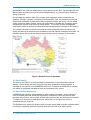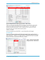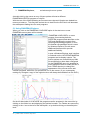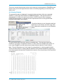
1
PINNEENA Water Quality PINNEENA WQ Version 11.1 Published by the NSW Department of Primary Industries, Office of Water PINNEENA WQ Ver 11.1 First published July 2015 ISBN 978-1- 74256-788-4 More information Water Monitoring / NSW Office of Water/DPI/ Parramatta www.dpi.nsw.gov.au Acknowledgments 13601 © State of New South Wales through the Department of Trade and Investment, Regional Infrastructure and Services, 2015. You may copy, distribute and otherwise freely deal with this publication for any purpose, provided that you attribute the NSW Department of Primary Industries as the owner. Disclaimer: The information contained in this publication is based on knowledge and understanding at the time of writing (July 2015). However, because of advances in knowledge, users are reminded of the need to ensure that information upon which they rely is up to date and to check currency of the information with the appropriate officer of the Department of Primary Industries or the user’s independent adviser. PINNEENA WQ Version 11.1 Table of Contents PINNEENA Water Quality– Version 11.1 .......................................................................... 5 NSW’s Water Quality Archive on DVD .............................................................................. 5 1.0 INTRODUCTION ........................................................................................................ 5 1.1 Importance of Water Data ....................................................................................... 5 Table 1 - World-Wide Flow Variability. ........................................................................... 6 1.2 Water Quality .......................................................................................................... 6 1.2.1 Surface water Quality ........................................................................................ 6 1.2.2 Water Quality Data Collection ........................................................................... 7 1.2.3 Typical Water Quality Project - Namoi Water Quality Project .......................... 7 1.2.4 Waterwatch NSW.............................................................................................. 7 1.2.5 Groundwater Quality ......................................................................................... 7 1.2.6 Threats to Groundwater Quality ........................................................................ 9 Figure 3 – Groundwater Salinity Map ........................................................................10 1.3 Data on Pinneena WQ............................................................................................10 1.3.1 KiWQM – Database for Manually Monitored Bores ..............................................10 1.4 Pinneena Updates ..................................................................................................11 1.5 License Agreement ................................................................................................11 2.0 DISCLAIMER .............................................................................................................12 2.1 Data Analysis .........................................................................................................12 2.1.1 Hydrologic Trends ............................................................................................12 2.1.2 Climate Zones in NSW .....................................................................................12 2.2 Data Quality ...........................................................................................................13 2.3 Data Quality Assurance ..........................................................................................13 3.0 SETTING UP PINNEENA WQ 11.1. DVD ..................................................................14 3.1 What you need to use the PINNEENA DVD ...........................................................14 3.3 Pre-Installation checks ...........................................................................................15 3.4 PINNEENA DVD Set-up .........................................................................................15 3.4.1 Installation in Windows 7 and Windows 8........................................................16 3.5 Product Support .....................................................................................................22 3.6 Acknowledgement ..................................................................................................22 4.0 PINNEENA DATA ......................................................................................................23 4.1 Data Available ........................................................................................................23 4.1.1 Conductivity Data .............................................................................................23 1 | NSW Office of Water, May 2015 PINNEENA WQ Version 11.1 4.1.2 Temperature ....................................................................................................23 4.1.3 Turbidity ...........................................................................................................23 4.1.4 pH ....................................................................................................................23 4.1.5 Dissolved Oxygen ............................................................................................23 4.1.6 Nitrates & Phosphates .....................................................................................24 4.1.7 Metals ..............................................................................................................24 4.1.8 Chlorides, Sulphates etc ..................................................................................24 4.1.9 Total Dissolved Solids ......................................................................................24 4.2 Key Concepts .........................................................................................................24 4.2.1 Site Location ....................................................................................................24 4.2.2 Data Type ........................................................................................................25 4.2.3 Output Destination ...........................................................................................26 4.3 Other Useful PINNEENA WQ Concepts .................................................................26 4.3.1 “Continuous” Data ............................................................................................26 4.3.2. Time Series Variable Numbers .......................................................................27 4.3.3 Quality Codes (For Time Series Data only) ......................................................28 5.0 OPERATING PINNEENA...........................................................................................28 5.1 Using PINNEENA Explorer .....................................................................................29 6.0 MAP INTERFACE TO DATA......................................................................................31 6.1 Using the map to view data ....................................................................................31 6.2 Using the Map to select groups of sites ..................................................................33 6.3 Data Archive ...........................................................................................................34 6.3.1 Site Details.......................................................................................................34 6.3.2 Time Series......................................................................................................35 6.3.3 Outputting Data from MapView ........................................................................36 6.3.4 Databases........................................................................................................37 6.3.5 Reports ............................................................................................................37 6.3.6 Mapping Interface Components ......................................................................38 6.3.7 Shortcut Buttons ..............................................................................................38 6.3.7.1 Map Window .................................................................................................38 6.3.7.2 View Window ................................................................................................38 6.3.7.3 Key Box ........................................................................................................38 6.4 Pan and Zoom ........................................................................................................39 6.4.1 Movement Buttons ...........................................................................................39 6.5 Mouse Functions ....................................................................................................39 2 | NSW Office of Water, May 2015 PINNEENA WQ Version 11.1 6.5.1 Mode Box.........................................................................................................39 6.5.2 Status Line Controls .........................................................................................40 6.5.3 View Menu .......................................................................................................40 6.5.4 Find Menu ........................................................................................................41 6.5.5 Mode Menu ......................................................................................................41 6.5.6 Selection ..........................................................................................................41 7.0 OBTAINING HELP .....................................................................................................43 7.1 PINNEENA Help.....................................................................................................43 7.2 HYDSTRA Help ......................................................................................................43 7.2.1 Other Help Features - Index .............................................................................44 7.2.2 Other Help Features - Search..............................................................................44 7.3 In Program Help ..................................................................................................45 7.3.1 Data Wizard .....................................................................................................45 7.3.2 Selecting Site from the Site Table ....................................................................45 7.3.3 Selecting a Site from the Archive .....................................................................46 7.3.4 Selecting a Site from the Period Table .............................................................46 7.4 Filling in the Other Data ..........................................................................................46 8.0 ANALYSIS PROGRAMS............................................................................................48 8.1 General ..................................................................................................................48 8.2 Data Extraction Programs ......................................................................................48 8.3 Extraction Programs ...............................................................................................52 8.4 Viewing Outputs .....................................................................................................53 8.4.1 Modifying Outputs ...............................................................................................54 8.4.2 Zoom Facility .......................................................................................................54 8.4.3 Useful Menu Options .......................................................................................54 8.4.4 Edit ..................................................................................................................54 8.4.5 Options ............................................................................................................55 9.0 DATABASE PROGRAMS ..........................................................................................55 9.1 General ..................................................................................................................55 9.2 Linked Databases...................................................................................................58 9.3 Menu Options .........................................................................................................59 9.3.1 File ...................................................................................................................59 9.3.2 Manage ............................................................................................................59 9.3.3 Edit ..................................................................................................................59 9.3.4 View .................................................................................................................60 3 | NSW Office of Water, May 2015 PINNEENA WQ Version 11.1 9.3.5 Tools ................................................................................................................60 9.4 Filter .......................................................................................................................60 9.4.1 From a Point ....................................................................................................60 9.4.2 From a Rectangle ............................................................................................60 9.5 Data .......................................................................................................................60 9.6 Help........................................................................................................................61 Appendix A - WQ Data from Manually Sampled sites, ....................................................62 1.0 Manually Monitored Sites ...........................................................................................62 1.1 Site Numbering.......................................................................................................62 1.2 Data Source ...........................................................................................................62 1.3 Variable ..............................................................................................................62 Outputs ........................................................................................................................62 2.0 Continuously Monitored WQ Sites .............................................................................63 2.1 Stream Gauges and Bores .....................................................................................63 2.1.1 Six Digit Gauging Stations and Bores ..............................................................63 2.1.2 Data Source .....................................................................................................63 2.1.3 Variable ...........................................................................................................63 2.1.4 Input Screen ...................................................................................................63 2.1.5 Output ..............................................................................................................63 3.0 Plots from MAPS........................................................................................................63 3.1 General ..................................................................................................................63 3.1.1 WQ All Sites....................................................................................................64 3.1.2 WQ Manual ................................................................................................64 3.2 Typical Box and Whisker Diagrams ........................................................................64 3.3 Plots , etc ...............................................................................................................65 APPENDIX B – Water Quality Variables (Name/No)) ......................................................66 Appendix C - PINNEENA 11.1 Short Cut Keys ...............................................................91 Appendix D - Product Evaluation ...................................................................................... 1 4 | NSW Office of Water, May 2015 PINNEENA WQ Version 11.1 PINNEENA Water Quality– Version 11.1 NSW’s Water Quality Archive on DVD "Knowledge is of two kinds. We know a subject ourselves, or we know where we can find information upon it." Samuel Johnson 1709 – 1784 1.0 INTRODUCTION In producing the original surface water PINNEENA CD-ROM in 1990, the then Department of Water Resources provided significantly enhanced access to its surface water data archive. It was hoped that the people planning, managing and developing NSW's water resources would benefit by having all the data both widely available, and at an appropriate technology level. While technology has advanced since the first PINNEENA, this form of data publishing still remains the most effective method of making such large amounts of data available although now a DVD is required to handle all the data provided. The response from within Australia, and from overseas, encouraged that Department and its successors (currently the NSW Office of Water (NOW)) to continue to publish its surface water data on the PINNEENA CM (Continuous Monitoring) DVD and to produce PINNEENA GW (Groundwater) disks. The first of which was produced in 2006. The Water Quality data collected from the Department of Water Resources days is now available in PINNEENA WQ (Water Quality) disks. This DVD contains all of the data from the NSW Office of Water’s Water Quality archive. 1.1 Importance of Water Data According to the 1991 WMO/UNESCO publication "Water Resources Assessment Progress in the Implementation of the Mar del Plata Action Plan and Strategy of the 1990s". "...while the world's fresh-water resources are massive, they are not only unevenly distributed in both space and time but also have a finite limit in terms of practical utilisation. .... improving knowledge of the globe's water resources is indispensable for the well-being of mankind and for the protection of the environment. Reliable information on the state and the trends of water resources is a prerequisite for sound decisions on their sustainable management." Our water resources around the world are under a number of pressures that drive the need for accurate long term water data. Everywhere the hydrological cycle is being modified quantitatively and/or qualitatively. Human activities such as; land use change, urbanisation, water storage, inter-basin transfer, irrigation and drainage have major impacts on both the quality and quantity of the resource. It is probable too, that global climate change will have an impact on water resources throughout the world. Water data is particularly important in Australia, where evidence suggests that not only is the driest inhabited continent in the world, it also exhibits runoff variability greater than on any other continent except South Africa as shown in Table 1. It has been argued that this variability is not just a product of the variable rainfall but also a product of Australia's unique vegetation and its evapro-transpiration methods. 5 | NSW Office of Water, May 2015 PINNEENA WQ Version 11.1 This variability in Australian conditions has been recognised with the Australian Water Resources Council stating that " ... with regard to water resources - the flat topography, aridity, spatial and temporal climatic variability and biological distinctiveness have produced an aquatic environment to which much overseas research is inapplicable" (AWRC 1989) Thus it is imperative that Australian authorities both collect and use data from within Australia when making natural resource related decisions. PINNEENA GW provides just such a resource. Table 1 - World-Wide Flow Variability. Area Annual Flow Variation Peak Flow Variation World 0.43 0.28 Northern Africa 0.31 0.18 Asia 0.38 0.24 North America 0.35 0.25 South America 0.35 0.14 Europe 0.29 0.17 Southern Pacific 0.25 0.22 Southern Africa 0.78 0.46 Australia 0.70 0.45 Source: Finlayson and McMahon 1991 1.2 Water Quality 1.2.1 Surface water Quality The quality of the waters in our rivers and aquifers is naturally influenced by inputs of salt and nutrients from the surrounding landscape and its geology. However, water quality can also be degraded by a wide range of factors including point source activities such as sewage discharge and mine wastes, and diffuse source activities such as land clearing and cultivation, urban and agricultural development. The regulation of river flow by major storages and weirs and the extraction of water have also influenced the quality of water with many rivers receiving fewer flow events and floods which naturally clean and flush the river. While lowered water quality may only be a short–term problem for rivers, water in our groundwater systems has often been stored for thousands of years so any contamination has long-lasting impacts. At a national level, the National Water Quality Management Strategy provides guidance on water quality planning and management and establishes guideline values for various water quality measures. In NSW, interim water quality objectives have been established in consultation with the community that help decision makers consider water quality in both big picture strategic planning such as Catchment Action Plans and Regional Strategies, and at the local level when assessing impacts of developments. The Office of Water, through its water licences, also requires that contaminated irrigation or mining water not be returned directly to rivers and groundwater. The Office of Environment and Heritage licenses the discharge of sewage and other point source pollution. 6 | NSW Office of Water, May 2015 PINNEENA WQ Version 11.1 Figure 1 a – Laboratory Testing Figure 1b Sampling 1.2.2 Water Quality Data Collection Water Quality data collection was carried out under various Water Quality Programs which is managed by Project Managers. There are about 350 Water Quality Projects and some of them existed for the period of the studies/ Projects. For example Liverpool Plains project was active between August 96 & Dec 97. GWYDIR Water Quality Project existed between July 2002 to Nov 2007 and similarly the Namoi Water Quality Project. 1.2.3 Typical Water Quality Project - Namoi Water Quality Project The NSW Office of Water has a number of programs that assess water quality and try to improve it. One such program, the Namoi Water Quality Project, commenced in July 2002 and ran for a period of five years. Basic water quality attributes were monitored on a monthly basis at a total of 29 sites. Monitoring of agricultural chemical residues was undertaken at sites located in the main dryland and irrigated cropping areas of the Namoi valley. Results indicate that good agronomic practices in conjunction with the management of riparian vegetation to reduce stream bank erosion provide simple and effective means to improve water quality in the long term. Read the final report Namoi Water Quality Project 2002-2007 (PDF 1.5 MB). 1.2.4 Waterwatch NSW Waterwatch NSW is a community based program in water quality monitoring. The aim of the program is to have the public and local organisations involved in regular water quality monitoring activities to inform government, the community and natural resource management organisations on the health of our local waterways. To assist Waterwatch groups, the Office of Environment and Heritage in partnership with the Commonwealth Government developed new resource material and a new Waterwatch database for users which were released in 2010. These resources include manuals, guides and posters that can assist groups in the field on water quality sampling methods and techniques. The Waterwatch database allows Waterwatch groups to enter water quality monitoring results from their local area or chosen site. The information is then used by Local Land Services and other organisations to develop an indication of water quality health in a particular area. The information collected may also provide an indication of upstream health and what other factors may be impacting the health of a lake, river or estuary. 1.2.5 Groundwater Quality While groundwater occurs everywhere below the ground surface. It varies greatly however in quality, quantity and depth depending on host rock type, the nature of the overlying soils and the rainfall of the region. 7 | NSW Office of Water, May 2015 PINNEENA WQ Version 11.1 By its nature, groundwater is often less susceptible than surface water to short term depletion and contamination. However, if excessively depleted or polluted, there is often little that can be done to restore a groundwater system to its natural state. In NSW, the quality of groundwater varies dramatically from region to region. One measure of quality is the level of natural salt content present in groundwater. As stated before salinity levels can range from that of rainwater to more than 10 times that of sea water. The lowest salinity groundwater can generally be found in the large unconsolidated alluvial systems associated with the major westward draining rivers. Many coastal sand dune systems also contain low salinity water, as do the consolidated sediments of the Great Artesian Basin which occur at depth in the north west of the State. Figure 3 shows groundwater availability and salinity across NSW. Groundwater quality is known to be deteriorating in many parts of the State through contamination from human activities such as urban and rural development, use of fertilisers and pesticides, leaking sewage pipes, septic tanks, tip sites, mining and seepage from contaminated lands. Figure 2 Groundwater Quality Sampling at a Bore Also, surface water systems into which groundwater flows, such as wetlands, may have environmental values and require the incoming waters to be of a very high quality. The protection of groundwater resources in such areas is an important aspect of total water management. Table 3 Types of Groundwater Quality Monitoring Undertaken in NSW Area Alluvium No. bores Type of analysis Purpose 170 Major cat ions and anions WSP 390 Field EC Salinity management 75 Field EC WSP 2 Major cat ions and anions Background sampling in CSG areas 17 Major cat ions and anions Background sampling in CSG areas 75 Field EC WSP Fractured Rock 25 Field EC WSP Coastal sands 75 6 Major cat ions and anions WSP Salt water intrusion Porous Rock 8 | NSW Office of Water, May 2015 PINNEENA WQ Version 11.1 When groundwater is extracted and used for irrigation, proper consideration must be given not only to the quality of the waters but also to the compatibility of the water with respect to the soil and crops on which it is to be applied. If not, it could cause a breakdown in soil structure, salinisation of the root zone, leaching of salts to underlying groundwater and, ultimately, the movement of salts into creeks and rivers. Groundwater that has a high sodium adsorption ratio, for instance, should not be used on sodic soils. Saline drainage flows need to be managed to prevent contamination of surface waters. Similar problems occur in the bore drains used to distribute water from flowing bores in the Great Artesian Basin. Here the continual use of low gradient drains that pass through sodic soils with limited leaching capacity has caused a build-up of soil salinity in the immediate vicinity of the drains. This has often caused native vegetation to die off and be replaced with non-native salt-tolerant species. There is only a recent awareness of the significant role played by groundwater as a component of the physical environment. This awareness has resulted from the observation of the impacts of rising and falling water levels. A consequence of rising water levels is the emergence of poor quality water into streams, wetlands and soils, while falling water levels have resulted in the drying of some wetlands and many of the mound springs of the Great Artesian Basin, as well as a reduction in base flows to many streams. Many surface water ecosystems are largely dependent on groundwater, and their protection is directly related to its protection. In many situations, the naturally poor quality of groundwater may diminish the perceived need for protection, unless the significance of groundwater as a support to more sensitive water environments is taken into account. Contamination of brackish aquifers, particularly where they are highly permeable, can lead to serious degradation of surface water environments receiving such groundwater discharges. Consequently, the environmental value of groundwater can in some cases be the critical factor which determines protection measures. 1.2.6 Threats to Groundwater Quality Unlike rivers, which flow in defined channels, groundwater is present everywhere beneath our feet. Many of our activities, therefore, pose potential threats to the quality of our groundwater resources. Many low lying sites were progressively filled in with industrial and urban waste in the first half of this century in the industrial centres of Sydney, Newcastle and Wollongong, causing contamination of the groundwater. Contaminated groundwater systems can pose a threat to other connected ecosystems. Wetlands, for example, are often degraded by groundwater that has become polluted through the burial of waste in the immediate catchment. Generally, contamination can be described as coming from either ‘point’ sources or ‘diffuse’ sources. Point source contamination may range from land fill sites (for example domestic tip sites and industrial land fill sites), to animal-based waste from abattoirs, cattle feed lots and piggeries. Diffuse source contamination includes the spreading of fertilisers onto agricultural land, urban runoff and the fallout from industrial smoke stacks. Along with threats from surface activities, there is a very real danger that pumping large volumes of groundwater will result in deterioration in water quality where poor quality water is drawn into aquifer containing high quality water. 9 | NSW Office of Water, May 2015 PINNEENA WQ Version 11.1 Figure 3 – Groundwater Salinity Map If groundwater becomes polluted, it is difficult or impossible to clean up completely. The slow rates of groundwater flow and low microbial activity limit any self-purification. Processes which take place in days or weeks in surface water systems may take decades to occur in groundwater. In addition, the costs of remediating groundwater systems are very high. It is, therefore, better to prevent or reduce the risk of groundwater contamination than to deal with its consequences. 1.3 Data on Pinneena WQ NOW monitors (manually & using probes etc.). around 300 sites Water Quality on an Annual basis. Manually collected samples are tested at Laboratories and Archived in KiWQM database. Water Quality collection and testing started in the 1900’s and there are about 24,500 sites that has WQ data of which 18,500 are sampled from Ground Water Bores. Many bores have only single reading (e.g.: GW000001 has data for 26/7/1994 only). There are about 460 sites that have continuously monitored WQ data which has Electrical Conductivity, Temperature, pH, Turbidity, Dissolved Oxygen etc. Based on records, continuously monitored Temperature data started in 1962 at Snowy River @ Jindabyne. Continuously Monitored EC data started in 1972 at Brogo River d/s Brogo Dam. 1.3.1 KiWQM – Database for Manually Monitored Bores A main focus of the implementation of the new system for managing water quality samples was the seamless integration with the existing NOW systems, in particular Hydstra, which is applied for handling all time series data. The KiWQM client will be accessible for users through Hydstra within the Hydstra application menu. This will allow users to work on water quality and sample data (KiWQM) and time series data (Hydstra) starting from the same platform. In addition KiWQM data can be exported directly to the Hydstra WQ warehouse where it can then be treated as any other data sources and exposed to Hydstra functionality. 10 | NSW Office of Water, May 2015 PINNEENA WQ Version 11.1 Figure 4 Water Quality Monitoring Locations 1.4 Pinneena Updates The PINNEENA DVD version numbers reflects both the version of HYDSTRA software on the DVD and the data updates. So PINNEENA DVD N.3 indicates that Version N of HYDSTRA is being used and that it is the 3rd data update in this series. If the next PINNEENA DVD still used Version N of HYDSTRA, the next PINNEENA DVD version number would be N.4. Future updates of PINNEENA DVD will take place at irregular intervals (typically every 2 years) depending on: • Product demand • Data quality changes • Software enhancements 1.5 License Agreement The contents of this DVD are protected by copyright law. Copyright in this material resides with the State of New South Wales through the NSW Office of Water or various other rights holders, as indicated. By using this DVD you agree to the following and accept the following conditions and terms of the 'privacy' and 'accessibility' statements available on the NSW Office of Water web site http://www.water.nsw.gov.au Intellectual Property Laws Protect this Site Apart from any fair dealing or other statutory use permitted under the Copyright Act 1968, the terms and conditions of reuse of the material from this DVD are governed by the following: • 11 | Content identified by a specific copyright notice must be used according to the requirements of that notice NSW Office of Water, May 2015 PINNEENA WQ Version 11.1 • With the exception of coats of arms, emblems, images, other third party material or devices protected by a trademark, other content of this app is licensed under the: Creative Commons Australia Attribution 3.0 Licence. • You should familiarise yourself with terms and conditions (including disclaimer) of the Creative Commons licence. Other Terms and Conditions. Where the material is not licensed by the NSW Government under an access agreement or CC licence, or where the material is not owned by the NSW Government, you should contact the original copyright owner. Any permitted reproduction of copyright material, including fair dealing, must: • acknowledge the relevant rights owner as the source of any such material reproduced; • reference the copyright or licence conditions under which the material is provided on this app. 2. DISCLAIMER 2.1 Data Analysis This data reflects the natural conditions under which it has been collected. There are a number of factors that should be considered when any extrapolation or prediction based on this data is carried out. 2.1.1 Hydrologic Trends The use of hydrologic information including groundwater levels that is representative of long term conditions to support natural resource management decisions is very important in Australia because of the extremely variable climatic conditions that occur. Marked shifts in climate regime, known as secular changes, also occur from time to time. These climate characteristics are most pronounced in south-eastern Australia, and particularly in NSW. In NSW, rainfall, stream flow and other hydrologic data show that from about 1948 to the late 1990s the climate was significantly wetter on average than in the period from about 1890 to 1948. In terms of rainfall the increase is about 15% while in terms of streamflow increases of as much as 60% were noted. In addition, droughts tended to be much shorter during the period 1948 to 1990 than they were between 1890 and 1948. While data was sparser in the 19th century, it is evident that in about 1890 an opposite shift to that of 1948 occurred, and that other shifts up and down of varying magnitudes and durations occurred before 1890 (based on data from Lake George). Again from the late 1990s to 2010 the climate was significantly drier. Whether this trend will continue and/or for how long is yet to be determined. It is therefore apparent that secular changes in climate, either up or down, can occur at any time. 2.1.2 Climate Zones in NSW NSW covers a number of seasonal zones. In the inland there are three main rainfall zones. In the south of state the rainfall pattern is winter dominated (the Murray and Murrumbidgee basins), while in the north of the state the rainfall pattern is summer dominated (the Border Rivers, Gwydir and Namoi basins). The Macquarie and Lachlan basins are in a transition zone between winter dominated rainfalls in the south to summer 12 | NSW Office of Water, May 2015 PINNEENA WQ Version 11.1 dominated in the north. As always there are exceptions to the rules. For example with the Monaro area around Cooma (in the Murrumbidgee basin), any rainfall it gets is mainly in spring (Figure 8). On the coast and eastern side of the ranges local orographic effects complicate the situation. Dorrigo, Laurieton, Comboyne, the Barrington Tops, the Illawarra and around Gosford are examples of areas where local orographic effects are strong. On the North Coast, north from about Grafton, there is a winter peak in rainfalls due to onshore southeasterlies as well the usual summer rainfall peaks. The Hunter and the Warragamba catchments exhibit a mixture of coastal and inland characteristics (stronger in the Hunter). The climatic conditions in these zones and the various physical factors impact on the timing and amount of rainfall that are available to provide natural recharges to aquifers. As indicated earlier this could also be being impacted by secular changes in the weather. Figure 5 Rainfall Zones in Australia 2.2 Data Quality The data on this DVD is as recorded both by instruments in the field and by manual dipping . Gross editing and error correction has been undertaken where possible. is included on the archive or the PINNEENA WQ DVD. Therefore the NSW Office of Water can make no guarantee that data at sites are necessarily fully correct. 2.3 Data Quality Assurance PINNEENA WQ contains vast quantities of water quality information, some of which is over a hundred years old. While the Department continues to refine and correct data, because of the historic nature of the archive there will be errors and omissions in the data. To assist us to improve our data quality we would ask you to report any errors or omissions that you may find. The Department is working to quality certify its water quality data collection activities and it is looking to undertake continuous quality assurance reviews of its water quality 13 | NSW Office of Water, May 2015 PINNEENA WQ Version 11.1 monitoring data. Your feedback on any data or software errors in PINNEENA WQ will assist with this and contribute to improved data quality in future releases. We are also interested in hearing of your impressions, experiences and opinions on all aspects of PINNEENA WQ, including the data, the software and the documentation,. Included with this manual is an evaluation form which we would like you to complete and return once you have explored PINNEENA WQ and have some experience with its use,. 3.0 SETTING UP PINNEENA WQ 11.1. DVD 3.1 What you need to use the PINNEENA DVD PINNEENA is produced to ISO 9660 standards and requires an IBM compatible computer with a hard disk and DVD reader. PINNEENA will run on Windows 2000, XP, Vista, Windows 7, and Windows 8 and on both 32 and 64 bit versions of these operating systems where available. It will not run on Linux or older versions of Windows. This users’ guide assumes you are familiar with basic commands and procedures for the Windows operating system. Knowledge of surface water data and HYDSTRA are also considered desirable to utilise PINNEENA to its fullest potential, but they are not essential. Help is provided for using the data and tools on the PINNEENA DVD both directly from the programs themselves, and in this guide. Further advice if necessary can be obtained by contacting one of the numbers listed in the Product Support section 1.5 3.2 Computer Requirements The minimum configuration for running Pinneena are as follows (i.e. it still currently runs on a system with the following configuration, albeit very slowly): Intel Pentium II 500 • 640 Mb RAM • 50 Mb free disk space • SVGA Monitor (800*600) • Microsoft compatible mouse • DVD Reader • Windows 2000 However the recommended minimum configuration for reasonable performance would be along the lines of the following: • Intel Pentium 4 • 1 Gb RAM • 200 Mb free disk space • XVGA Monitor (1024*768) • Microsoft compatible mouse • DVD Reader • Windows XP Obviously the faster the CPU and the higher the amount of RAM the better the performance will be. All modern machines will run Pinneena. DVD speed is generally not an issue for most modern systems. 14 | NSW Office of Water, May 2015 PINNEENA WQ Version 11.1 A minimum of 50 megabytes of free hard disk storage is required on the PC for temporary files but more is better for PINNEENA and system performance. Pinneena has been tested in the following versions of Windows (as per table below). This version of PINNEENA will not run under any version of Linux, UNIX, DOS, Windows 3.X, Windows 95/98 or Windows NT 4. PINNEENA outputs text and high resolution graphics and a XVGA screen at 1024 by 768 pixels is the recommended minimum. Table 4 Operating Systems where Pinneena can be used Windows OS Version 2000 XP Vista 7 8 - 8.1 10 32bit 64bit √ √ √ √ √ √ √ √ √ PINNEENA will also produce graphical and textual outputs on any Windows supported output device. It is also possible to use the Windows clipboard’s cut and paste features to capture this output and paste into other applications eg MS Word. Note: The outputs from PINNEENA can contain large amounts of data. If plots are produced with missing or incomplete traces it is likely that the printer requires more memory. This is generally not an issue with modern PCs and printers. 3.3 Pre-Installation checks The PINNEENA DVD will run successfully on PC’s running Windows 8 and 8.1, Windows 7, Vista, XP, or Windows 2000. However, please note that we have discovered that some systems may have trouble reading DVD +R discs while others may have problems reading DVD -R discs. This issue is generally evidenced by not being able to fully install the PINNEENA software due to read errors from the disk. PINNEENA DVD is produced in both versions. If you have any troubles reading the DVD please inform us and send the DVD back to the Parramatta office where a replacement will be dispatched back to you. If the disk has been damaged and is unusable then you will be charged a replacement fee. 3.4 PINNEENA DVD Set-up There are some basic things you may need to do before you can successfully run the DVD on some older systems. The installation program checks that these things have been done and flags any areas of concern. However, it is up to you to make any necessary changes. 15 | NSW Office of Water, May 2015 PINNEENA WQ Version 11.1 Insert the PINNEENA disc in the DVD reader. Start Windows Explorer and find the SETUP.EXE file on the home/root directory level of the DVD. Run the SETUP.EXE program. This will create the entries in the Start Menu needed to run PINNEENA. The PINNEENA DVD must be in the DVD reader for the system to work. 3.4.1 Installation in Windows 7 and Windows 8 There can be some issues with installing the PINNEENA software under Windows 7 and/or Windows 8 due to the UAC (User Access Control) features of these operating systems. It is generally less of an issue in Windows 8 as Microsoft recognised the problems from Vista and have relaxed many of the restrictions and automated the responses. However there are still some common problems that can occur with either version: 1. You may be blocked from installing the program 2. A program may fail to operate due to lack of write permissions in the \Temp directory (HYDSTRA writes temporary files to the \Temp and \Temp\Temp directories and requires write permissions at this level) 3. Issues with accessing the HELP file contents 4. When the program has finished installing you may receive the following error shown below. Select Reinstall using recommended settings. To make the process more straight forward, we recommend that you are logged on as an administrator to install new programs. However for reasons best known to Microsoft, even though you may be logged into an administrator account, the install jobs don't normally run with admin privileges. We suggest that you try to install PINNEENA first. If this is successful, then run a test program such as HYCSV, as shown below. Go to the Start Menu > All Programs > Pinneena 10.1 > Select Pinneena Hyxplore, 16 | NSW Office of Water, May 2015 PINNEENA WQ Version 11.1 Within Hyxplore > Type HYCSV > Click on the Run button. To select a Site click on the button where the ? is (marked red in the picture below). 17 | NSW Office of Water, May 2015 PINNEENA WQ Version 11.1 Click on the Period button. The Browsing table well then appear. Click on 21910062 site > Then click on OK. The TS Data Wizard window will now appear. Click on the Next button. The Data Type will now appear on the TS Data Wizard window. Click on the Finish button. 18 | NSW Office of Water, May 2015 PINNEENA WQ Version 11.1 You will be bought back to the HYCSV program. Click on the Run button. The HYCSV program will now return the respective parameter data for the 20110003 Site. 19 | NSW Office of Water, May 2015 PINNEENA WQ Version 11.1 You have successfully run a test with the HYCSV program. This writes a file to the \Temp\Temp directory. If you are successful in both installing PINNEENA and running the program please ignore the following. Otherwise, if you are allowed/able to, you suggest that you briefly turn off the User Access Control in Control Panel (in Windows 8 go to Start | Control Panel | User Accounts). Don't forget to turn UAC on again after you have finished the installation and reboot your computer. While logged in as an administrator and with the UAC turned off use Window Explorer and right click on the PINNEENA SETUP.EXE file. Then select “Run as administrator”. Even with all this other messages may occur which indicate issues with the installation. These messages can include: 20 | NSW Office of Water, May 2015 PINNEENA WQ Version 11.1 Open Windows Explorer and browse the PINNEENA DVD. Find and install the file from the CD as indicated ie \hyd\sys\setup\ado\VFPODBC.msi Open Windows Explorer and browse the PINNEENA DVD. Find and install the file from the CD as indicated i.e. \hyd\sys\setup\msmxl\msxml.msi Another message that may appear is shown below. 21 | NSW Office of Water, May 2015 PINNEENA WQ Version 11.1 This requires that you select Start | Run... and enter the following text Regsvr32 d:\hyd\sys\run\hydll.dll Where d: = the drive letter of your DVD drive This is shown in the following screen shot: Also, if you have problems with accessing the Help file contents, ie you see the menu on the left hand side but it returns no content in the right hand panel then please follow the instructions below: If this occurs you will need to run the CHM.REG file from the DVD in the HYD\SYS\RUN directory. Again you have to be logged in as an administrator; then use Windows Explorer to find this file on the DVD, right click on it, select run with admin privileges. Again it may be required to do this with UAC turned off. 3.5 Product Support If you have a question about the PINNEENA DVD or any of the data and you cannot find the answer in this guide, or if you would like to take advantage of the NSW Office of Water ’ services to analyse or validate data sets used, please contact the Water Data Systems Team of the NSW Office of Water in Sydney on the following: Phone: 02 8838 7874 Fax: 02 8838 7854 Email: [email protected] or [email protected] Support for general questions about Groundwater data can also be obtained from the Office’s hydrogeological centres in: PENRITH Tel: 02 4729 8128 Fax: 02 4904 2503 Newcastle Tel: 02 49042565 Fax: 02 4904 2503 Deniliquin Tel: 03 5898 3948 Fax 03 5881 3465 Wollongong Tel: 02 42249746 Fax: 02 42249650 3.6 Acknowledgement Kisters Pty Ltd owns the copyright to the HYDSTRA software used on the PINNEENA DVDs. This software is used under license. 22 | NSW Office of Water, May 2015 PINNEENA WQ Version 11.1 4.0 PINNEENA DATA 4.1 Data Available PINNEENA contains the majority of the information stored in the NSW Office of Water’s (NOW) Surface water & Water Quality Archive. This version of PINNEENA contains the following data in its archive files (this does not include data that has been collected but not yet processed): • Continuously Monitored EC, Temp, Turbidity, pH Gauging Stations. data approx. 500 Stream • Continuously Monitored EC, Temp, Turbidity, pH bores. data approx550 Groundwater • Manually Monitored WQ data for 2840 Surface Water sites • Manually Monitored WQ data for 7950 Groundwater sites The data is from both current and discontinued monitoring sites. At present NOW’s Water quality archive maintains records relating to all Surface Water and Ground water Quality data collected manually and tested at Laboratories and Surface and Groundwater data collected by loggers and Archived in the Continuously Monitored Archives. 4.1.1 Conductivity Data This is a measure of the capability of a solution such as water in a stream to pass an electric current. This is an indicator of the concentration of dissolved electrolyte ions in the water. It does not identify the specific ions in the water. However, significant increases in conductivity may be an indicator that polluting discharges have entered water. 4.1.2 Temperature Water temperature is affected by air temperature, stormwater runoff, groundwater inflows, turbidity, and exposure to sunlight. In considering the health of organisms, it is necessary to consider their maximum temperature and optimum temperature.. 4.1.3 Turbidity Turbidity is a measure of how particles suspended in water affect water clarity. It is an important indicator of suspended sediment and erosion levels. Typically it will increase sharply during and after a rainfall, which causes sediment to be carried into the creek. 4.1.4 pH pH is a measure of a solution's acidity. In water, small numbers of water molecules (H2O) will break apart or disassociate into hydrogen ions (H+) and hydroxide ions (OH-). Other compounds entering the water may react with these, leaving an imbalance in the numbers of hydrogen and hydroxide ions. 4.1.5 Dissolved Oxygen Dissolved oxygen is oxygen gas molecules (O2) present in the water. Plants and animals cannot directly use the oxygen that is part of the water molecule (H2O), instead depending on dissolved oxygen for respiration. Water at higher temperatures and altitudes will have less dissolved oxygen. Dissolved oxygen reaches its peak during the day. At night, it decreases as photosynthesis has stopped while oxygen consuming processes such as respiration, oxidation, and respiration continue, until shortly before dawn. 23 | NSW Office of Water, May 2015 PINNEENA WQ Version 11.1 4.1.6 Nitrates & Phosphates Nitrogen is abundant on earth, making up about 80% of our air as N2 gas. Nitrate enters streams from natural sources like decomposing plants and animal waste as well as human sources like sewage or fertilizer. Nitrate is measured in mg/L. Natural levels of nitrate are usually less than 1 mg/L. Phosphorus in small quantities is essential for plant growth and metabolic reactions in animals and plants. Sources of phosphate include animal wastes, sewage, detergent, fertilizer, disturbed land, and road salts used in the winter. 4.1.7 Metals Sodium is a very active metal which does not occur in nature in a free state. High concentrations of sodium will reduce the suitability of water for irrigation or house plant watering use. Potassium concentrations in water are generally very small. Although excessive intakes may have a laxative effect, public health authorities have not established a maximum limit. Iron in concentrations greater than 0.3 mg/L and manganese in concentrations greater than 0.05 mg/L may cause brown and black stains on laundry, plumbing fixtures and sinks. Calcium and Magnesium are important contributors to water hardness. When water is heated they break down and precipitate out of solution, forming scale. 4.1.8 Chlorides, Sulphates etc High concentrations of chloride ions may result in an objectionable salty taste to water and the corrosion of plumbing in the hot water system. Water containing high levels of sulphates, particularly magnesium sulphate (Epsom salts) and sodium sulphate ( Glauber's salt) may have a laxative effect on persons unaccustomed to the water. 4.1.9 Total Dissolved Solids High concentrations of total dissolved solids (TDS) may cause adverse taste effects. Highly mineralized water may also deteriorate domestic plumbing and appliances. It is recommended that waters containing more than 500 mg/L of dissolved solids not be used if other less mineralized supplies are available. less mineralized supplies are available. 4.2 Key Concepts There are a number of things that you must know before you can access the data from most programs on Pinneena WQ 4.2.1 Site Location All monitoring sites operated by NOW are allocated a unique site number. You must know this number to be able to access the site’s associated data. 24 | NSW Office of Water, May 2015 PINNEENA WQ Version 11.1 Figure 6 Sample Pinneena WQ Program Screen – Site Location There is no information associated with a Groundwater monitoring site number unlike surface site numbers which indicate what river basin they are in. The numbers are allocated somewhat sequentially in order of registration from any part of the state. All Surface water site numbers follow the same pattern: 210001 or 41210001 and for Groundwater sites: GW075033 – ie the GW identifier and 6 integers 4.2.2 Data Type Two type of data are provided on this DVD manual measurements, predominantly all Water quality data, and time series measurements which include water level, EC at 25C water temperature , Turbidity, pH , height and flow. The data comes from two separate locations and needs to be accessed differently ( A &WW). Figure 7 Sample Pinneena WQ Program Screen - Data Source 25 | NSW Office of Water, May 2015 PINNEENA WQ Version 11.1 Time series data comes from compressed binary files while the manual measurements come from databases. The PINNEENAWQ system will handle accessing and using this data for you but you need to which data it is that you want. A data source is a means of telling the PINNEENA programs where to get time series data from. It is both a powerful and complex tool but happily the majority of users will only ever use a quite small number of those sources available. The types of data sources currently supported are: • Time series data files, • Time series data in non-standard directories • Data from various database tables within Hydstra, • Data from various database tables from other systems, applications and types of databases • Constant values, In PINNEENA WQ 4.2.3 Output Destination PINNEENA GW has the ability to send data to many locations and in many formats. 4.3 Other Useful PINNEENA WQ Concepts While as much as possible has been done to hide some of the complexities of data discovery and data reporting there are still a number of other concepts that should be understood before attempting to use some of the more complex tools available on PINNEENA GW. Most of the following concepts apply primarily to Time Series data and those users familiar with PINNEENA CM should have already been introduced to them. 4.3.1 “Continuous” Data While this is not the most common type of data stored on the PINNEENA GW DVD it is still important. It should be recognised that the name is something of a misnomer in that the data as stored is not continuous rather it is digitally sampled at regular enough intervals to allow an accurate representation of the continuous trace of the data. With the advancing technology, analogue devices such as a chart recorder, made it possible to continuously record the hydrometric processes as they occurred in nature. However to store this continuous data in computers, it was then necessary to sample it a discrete intervals, ie to digitise the data. These intervals were chosen so that the data points extracted were able to accurately represent what had occurred in the continuous process. With digital data loggers being used today, this sampling is done automatically. Typically on NSW streams, the recording interval is between 5 - 15 minutes while in groundwater bores the sampling interval is most commonly 60 minutes. 26 | NSW Office of Water, May 2015 PINNEENA WQ Version 11.1 The following plot shows the data displayed using the LINEP (or line and point) option from the HYDSTRA program HYPLOT. Typically the data points are at 15 minute intervals. You may notice some periods where there are no points. This is a feature of HYDSTRA. Where many points fall on a line only the start and end points need to be stored. Any information between these two points can be interpolated. Removing the points compresses the data file size and speeds operation of the programs. Figure 8, Graph showing the Data Points as stored 4.3.2. Time Series Variable Numbers Many different types of data types can be collected at one site. To distinguish these different types of data they are allocated unique “Variable Numbers”, and many different “variables” or types of data for the same site are held in a single data file. Common variables available on PINNEENA are: Stored Data – raw data as collected from the field 10.0 110.0 121.0 2010.0 2012.0 2080.0 Rainfall (millimetres mm) Water level below measuring point (metres m) Bore water barometric pressure (kilopascals kpa Water Conductivity (microsiemens /cm @25C) Uncompensated Conductivity (microsiemens /cm) Water Temperature (degrees Celsius) Other common Variable Numbers which are not stored but are used frequently and are computed on demand by programs within PINNEENA include: Computed Data – calculated from the raw data 2010.0 2169.0 2301.0 2351.0 Water Conductivity Salinity (TDSalts) Calcium as Ca Dissolved Oxygen (microsiemens/cm @25C) (Milligrams per Litre) (Milligrams per Litre) (Milligrams per Litre) Note: It is now standard practice to record uncompensated EC (2012) at a site as well as the temperature (2080). Combination of these two pieces of information in conjunction with knowledge of the ions present in the water produces the standard report variable Electrical Conductivity at 25C (2010). Prior to 2008 it was common practice for this data to be combined in the logging device and just a value for electrical Conductivity @ 25C to be stored. 27 | NSW Office of Water, May 2015 PINNEENA WQ Version 11.1 A full list of variables is available from the Variables Database in the HYDSTRA menus. 4.3.3 Quality Codes (For Time Series Data only) So that data users can know whether the data they are using has been measured or estimated and whether they are the actual or adjusted readings each data point stored in a site’s data file has a quality code associated with it. These codes are to assist modellers with quantifying model uncertainty; resource managers to know how close the recorded value is to a fixed reference, etc. When collecting the data various forms of a fixed reference are used to verify the veracity of the data. The fixed reference for water level may be a gauge height from gauge plates installed in the river bank which has been levelled to a recognised benchmark. For a water quality parameter a value may have been measured by a portable instrument, which has been checked against a traceable standard. As well, manufacturers generally specify accuracy in terms of a percentage of the full scale range of the equipment, rather than specifying a standard error. Their calibration procedures require that all test readings are within the specified tolerances, and instruments are rejected if they do not meet specifications. Thus, provided that instruments are calibrated regularly according to standard procedures, and that calibration check indicate results are within manufacturers’ specification, quality codes 1,3,5,7,9 can be interpreted to indicate that results are within a 95% confidence interval of the true value as far as instrument calibration is concerned. Quality codes in the range 2,4,6,8,10 are for data that are adjusted from the value read by the sensor. These quality codes can be extracted to digital files along with the values. The Print Codes associated with quality codes are shown on printed reports, but not on graphical outputs. Note: When undertaking data analysis using the HYDSTRA programs data with quality codes greater than 150 are automatically discarded. Also many of the data conversions involve combining multiple quality codes. For example computed flow data is a combination of height and rating tables, each of which have their own quality codes. The resultant quality code of the computed flow is the worst of the height and ratings. The full list of Quality codes used by NOW are shown in Appendix C. 5.0 OPERATING PINNEENA After you have installed PINNEENA GW, four options will be added to the START MENU on your desk top under the PINNEENA GW 10.1 option: 1. HYDSTRA Help File online help for operating HYDSTRA programs 2. MAPHYD, 28 | a spatial, i.e. mapping, interface to the data NSW Office of Water, May 2015 PINNEENA WQ Version 11.1 3. PINNEENA Explorer, a windows style menu system A double click by the mouse on any of these options will start a different PINNEENA/HYDSTRA program or help file. With the use of the 32bit Operating environment some dynamic libraries are loaded into memory at start-up. This may take a short time to load from the DVD but it will decrease the subsequent loading time for most programs. 5.1 Using PINNEENA Explorer When you click on the PINNEENA HYXPLORE option in the start menu a new PINNEENA menu system will be started. PINNEENA HYXPLORE is a menu program for accessing both the HYDSTRA programs and data files on the DVD and displaying the outputs from reporting and plotting programs. It uses the familiar tree paradigm which is used by Windows Explorer, but with some additional features which provide additional flexibility. It uses a Windows Explorer style interface to find and run the HYDSTRA/PINNEENA programs and to display outputs. The menus options are controlled by an XML file and while they have been configured for the PINNEENA users it is possible for more advanced users to modify this file in their \TEMP directory to change the appearance of the menus and to add external programs, data files, Perl procedures, etc to the menus. (If you contemplate making any changes a copy of the original menus will always be available from the DVD.) On the left hand side of HYXPLORE the programs can be accessed in the menu tree by clicking on the folder icon and displaying the options beneath. The Folders are opened by clicking in the + box to the left of the description, or by double clicking on the description itself. 29 | NSW Office of Water, May 2015 PINNEENA WQ Version 11.1 Folders are closed by double clicking again, or by clicking on the - box to the left of the description. Folders are of various types, and the behaviour of the folder when opened depends on the folder type. Each folder option is displayed in the tree using a visual icon to indicate its type. A menu item preceded by a plus sign (+) implies that this item has further sub-menus to follow. At the lowest level are the programs themselves. Clicking on a program icon will start the program parameter screen (where you control the programs operation). Output from programs appears in the right hand side window of PINNEENA Explore. A range of shortcuts are also available on the Explorer screen as shown below. Rerun (Again) Search DOS Login Help Hide/ Unhide Runs the currently selected menu item, with the same parameters as used during the previous run. The Menus | Rerun menu option and the <F8> key does the same thing. Displays a dialogue box to search for a HYDSTRA menu item. You may search for any part of a menu item. Creates a DOS box in which you can run commands. The File | DOS shell menu option and the <F9> key does it also. Lets you login and change user IDs, not required for PINNEENA. Starts up the HYDSTRA help file, at the topic of the currently highlighted program. This hides/unhide the menus in the left hand pane to give your outputs greater viewing area. There are also a range of shortcut keys which will assist you in operating HYDSTRA programs. They include: [F1] is the help key as discussed above. [F8] is the rerun key; Allows you to re-run the last job. All the parameters from the last time you ran the program are restored and can be used again and/or edited. [F9] is the Shell to DOS key; at the DOS prompt - exit[ENTER] or closing the window will return you to the HYDSTRA menu. [ALT] [F4] will exit you completely from the HYXPLORE. [ESC] will take you from the parameter or menus screen to the next menu above. At the top line of the screen here is located a series of drop down menus, access to which may also be gained by pressing the [ALT] key and the underlined or highlighted character. These options also have shortcut keys so they can be accessed directly. Some of the more common options have been described above including [F1] for help. 30 | NSW Office of Water, May 2015 PINNEENA WQ Version 11.1 6.0 MAP INTERFACE TO DATA The MAPHYD program provides the easiest way to access to the data and reports on the DVD. All data can be accessed simply by using the mouse. MAPHYD can be loaded from the PINNEENA Explorer, PINNEENA Menu or alternatively the user can choose to start MAPHYD from the Windows Start Menu entry, The default map (NSW River Basins) is loaded automatically when the program is started from PINNEENA Explorer. Using the MAPHYD icon from the PINNEENA Start Menu starts the program without a map loaded. The maps then available on PINNEENA are: 1. NSW Macro Plans 2. NSW Local Government Areas 3. NSW All Bores, Monitoring Bores, Manually Monitored Bores 4. NSW Rivers To change to or select another map use the File menu option, choosing Open … and then selecting the map of your choice. This map will load for the current session only. The default map cannot be changed. On the maps the user can move around the state, panning or zooming into areas of interest. Figure 9 – View of Various layers in MAPS 6.1 Using the map to view data Zoom into the area of interest using either the Zoom Icon and selecting an area in the NSW Base Map main window or selecting an area in the smaller View window. (These actions are explained in more detail in the following section.) 31 | NSW Office of Water, May 2015 PINNEENA WQ Version 11.1 If a Site Layer is viewable and active (ie both tick boxes are selected in the Key Window), and the right mouse button is clicked when on a site (blue triangle) then a pop-up site descriptor appears on the screen with the site number and name. By right clicking on the this popup a program called Map View is started. This program, allows site-specific interactive of data from this site. When using Time series data ‘Data Source’ could be A or PROV. When using Discrete Data 32 | NSW Office of Water, May 2015 PINNEENA WQ Version 11.1 6.2 Using the Map to select groups of sites As an example NSW GW Map ALL is used in the example. From ‘Mode’ menu select ‘Radius Select’ or activate the icon . Move the curser to the centre of radius and expand the radius to the required extent. The selected area bores will change to red in colour while other bores remain (blue) in their original colour. Goto ‘selection’ and click the Save selection to File/Table. This will be automatically saved under c:\temp directory. For example name the file as ‘sample.txt’. The sample.txt file will look like pasted below This could be used as a file list for any program calls for ‘File List’ Data Extraction using HYEXTR 33 | NSW Office of Water, May 2015 PINNEENA WQ Version 11.1 Multiple outputs will be extracted as shown above. 6.3 Data Archive Data Archive will list the types of data available for the site. A mouse click on the green button or a double click on the menu items 6.3.1 Site Details Double clicking on Site Details will display site details from mthe site database. The site details view may be changed from spreadsheet/table view a to a form view using the Form View button. 34 | NSW Office of Water, May 2015 PINNEENA WQ Version 11.1 6.3.2 Time Series Double clicking on Time Series will show a list of data stored by variable for the nominated site. This uses the program HYSCANNR The program is also available from the Data Management option. This parameter screen gives the user a list of the data available for the nominated site. One or more variables may be selected for viewing by holding the ‘Control Key’ down when clicking the appropriate data line with the mouse. The following screen shows the ‘time line’ of the data. The period of record shows the start and end of the data, but does not indicate whether the data is continuous or not. The time line will show if there are any gaps in the data. By selecting Data Points or Show, the data itself can be displayed. 35 | NSW Office of Water, May 2015 PINNEENA WQ Version 11.1 Selection of Interval will show the data at the default interval. The display interval can be changed by clicking on the small down arrow to the right of the interval. The user may also zoom into the period of interest by moving the cursor to the start, pressing left mouse button, pulling along the horizontal line up to the end point and then releasing it. 6.3.3 Outputting Data from MapView A right mouse click on the trace will display a list of HYDSTRA programs that are available for use for that individual trace. If you select one of these, HYDSTRA will automatically complete the parameter screen for you using the start and end points of the window for the period. You can also use the Tools menu to select one of two programs that will operate on all traces you have selected. For example in the previous page we were 36 | NSW Office of Water, May 2015 PINNEENA WQ Version 11.1 displaying stream height and electrical conductivity. Using the HYPLOT option from the Tools menu we would get the parameter screen for a plot with these two traces. 6.3.4 Databases Returning to the MapView interface, double clicking on Database will display the HyDBView screen. Here you can select the database you wish to view. First choose a path under System and the click Hit Counts. HYDSTRA will check all databases in that system and display those with data for the nominated site By double clicking with the mouse or clicking the Browse button, select the database you wish to view. Then using the mouse and the four arrow buttons, you can browse your way through the database. The two left-hand buttons will toggle from a form view showing one record per screen to a table view listing the records in tabular form as shown on the next page. When you have finished, click the OK or Cancel button to return to the database selection screen. 6.3.5 Reports Returning to Map View, under the ‘Data’ tab you will find a menu option for ‘Reports’. This menu provides access to a range of pre-computed reports which can be viewed by clicking on the report title. The report will be displayed to the screen with the standard HYDSTRA screen options, ie to modify, to print the report or send to the clipboard. All these reports have been generated using HYDSTRA programs and stored on the DVD to save you having to run the programs yourself. They are a quick way to see what data is available at a site before examining the data in more detail. Clicking on a report (e.g. the HYMXMEAN plot) will open that report in the HYXPLORE window. 37 | NSW Office of Water, May 2015 PINNEENA WQ Version 11.1 6.3.6 Mapping Interface Components The HYDSTRA help system contains a comprehensive explanation of the components of MAPHYD. The following is a quick review of the more useful features. Menu Bar At the top of the screen is the menu bar, which provides access to all the functions of the mapping package. 6.3.7 Shortcut Buttons The shortcut buttons allow quick access to various menu actions. The buttons are explained in more detail in the following sections. 6.3.7.1 Map Window The large window on the left is the map window. It will display the map name in the top left hand corner. This is the active map viewing area where all connections to the data are made. 6.3.7.2 View Window The small window on the right is the View Window. It will always show the whole area of the map Aa rectangle indicating the current zoom position in the Map Window will appear when you have zoomed in on the main window to indicate your position.The mouse cursor is always in Zoom mode in this window. The View Window may be used to move quickly around the map. 6.3.7.3 Key Box The Key Box displays a symbol and some descriptive text for each map layer. 38 | NSW Office of Water, May 2015 PINNEENA WQ Version 11.1 Alongside these are check boxes for each layer. These are a shortcut to the layer's View and Active attributes. A right mouse button click on the key text presents a pop-up menu that allows changes to be made to a layer's display options. This will be discussed in more detail later. 6.4 Pan and Zoom 6.4.1 Movement Buttons The first 2 buttons with the magnifying glass icons are the zoom buttons. Pressing one of these will move the viewer in the given direction The current zoom step is 25%, which will move the map by 25% of its width in the main Map Window. The hand button will allow the user to grab the map and move it in any direction.. Zoom Right Out - Returns the main map window to the original zoom that the map opened in. Ctrl-O is a shortcut. Last View - Returns the main map window to its previous zoom. Alt-Backspace is a shortcut. Layer Control - A shortcut to the map's Layer Control dialog box. Ctrl-L is a shortcut. Zoom Right Out - Returns the main map window to the original zoom that the map opened in. Ctrl-O is a shortcut. Last View - Returns the main map window to its previous zoom. Alt-BackSpace is a shortcut. Layer Control - A shortcut to the map's Layer Control dialog box. Ctrl-L is a shortcut. 6.5 Mouse Functions 6.5.1 Mode Box The Mode Box contains a group of ten buttons that select the type of action a mouse click will perform in the Map Window. The modes in order from left to right are: Zoom Click in the Map Window. Drag the mouse until the rectangle contains the parts of the map you want to see. Release the button, and the Map Window is zoomed in on the required portion. To zoom in to a region, make sure that the region's layer is active (in the Key box) and simply click on that region (no dragging). The same applies to line objects. Move Hand 39 | Explained above NSW Office of Water, May 2015 PINNEENA WQ Version 11.1 Point Select Selects point objects, e.g. sites. Refer to the section on Selection Mode in the Selection menu details. Radius Select selects points in a circle. Region Select selects points inside a region. Line Select selects points within a given distance of a line. Freehand Region Select this region will be selected. allows a region to be drawn on the map and points inside Label The "top" object is labelled, i.e. the object in the uppermost layer under the mouse click. Info The "top" object is found and its layer and label are displayed in a dialog box. Move Point would allow point objects to be moved on a non DVD system 6.5.2 Status Line Controls At the bottom of the map there are several controls: Hints If this box is checked then all buttons, edit boxes and other components will display little pop-up hints when the mouse cursor moves over them. This is very helpful when you are learning to use the program. Drawing If ticked, the map drawing is displayed as it goes (i.e. builds the picture on the screen) un-ticked it will build the picture off-screen and just present the finished map. Zoom Indicator In the lower left corner is the zoom indicator. It shows the approximate distance (in kilometres) between the left and right edges of the map in the map window. Position Indicator Whenever the cursor is in the map window, its approximate position is displayed in the middle of the bottom line. Mode Indicator The current mode of the mouse's left button is displayed at the bottom of the screen. Selection Indicator Next to the mode indicator is another window which displays the number of currently selected points. 6.5.3 View Menu The view Menu provides options for moving about the main window. Zoom Out This command zooms out to the extents of the View Window. <Ctrl/O> is a shortcut. Last View Returns the main map window to its previous zoom state. Alt-Back Space is a shortcut. View Entire Layer This option presents a list of layers. Select the layer you wish to zoom to and the main map window will zoom in or out to contain the entire desired layer. NOTE: this has no effect on that layer's maximum zoom - so you may find that the map zooms out beyond the layer's maximum zoom. 40 | NSW Office of Water, May 2015 PINNEENA WQ Version 11.1 6.5.4 Find Menu The find menu has several options to assist in locating features on the map. Go to Lat/Long...Allows movement to a known location and predetermined zoom distance. The initial Lat/Long will be the centre of the current map window. The latitude and longitude are displayed in a dialog for manual refinement. The dialog has two "pages" - one for decimal latitude and longitude, and a page for the full degrees / minutes / seconds / hemisphere representation. Either page may be used with equivalent results. When the OK button is clicked, the main map window will be zoomed to centre on the requested location, and have the requested zoom distance across the map. Point Search... Finds a point object by specifying a portion of text. The text could be the whole or part of a gauging site name or number. Each object's label is scanned for this text. The search is case insensitive. If multiple objects are found, a list is presented. Note that this list also includes the layer name of the object. Zoom to Line... Presents a list of line objects in all layers. Double click on the line's identifier and the main map window will zoom in to contain the selected line. Zoom to Region...Presents a list of region objects in all layers. Double click on the region's identifier and the main map window will zoom in to contain the selected region. 6.5.5 Mode Menu The Mode menu indicates the selection method to be used during the selection. Layers may be temporarily selected or deselected for any session, just toggle the appropriate selected box with a mouse click Any selection operation adds to the current selection. To restart the selection, chose Selection|Clear Selection first. If the Shift key is held during one of the mouse-based selection operations (Select, Radius Select or Region Select) then the selected status of all the newly selected points will be reversed. 6.5.6 Selection These dropdown menus are used to select individual and groups of sites. Selections can only be made on those layers marked Active in the Key box eg. current and discontinued sites. Clear Selection Clears the current selection. All selected point objects are de-selected. Ctrl-C is a shortcut. Browse Selection... Displays a list of all currently selected point objects. Zoom to Selection zooms the main map window to display the entire selection. Load Selection... Loads a list file, e.g. one created by Save Selection..., and selects the objects that have an identifier contained in the list. 41 | NSW Office of Water, May 2015 PINNEENA WQ Version 11.1 The full path and file name needs to be specified, including the file extension. If the extension is .DBF, the file is assumed to be a dBase file. Otherwise the file will be read as an ASCII text file with the one identifier per line, and the site identifier as the first "word" on that line. An active layer is required. Click on this text box to display a list of selectable layers. The layer name displayed here will be the target of the selection. In the case of a database file, a list of fields is presented. Double click on the name of the field that will contain the object identifiers. Save Selection... Saves the current selection as a list of the selected objects' identifiers. A dialog box prompts for the name and type of file to produce. Use the File Type pick list to choose the type of file to save. If the file type is a database, then a dBase database file is produced. It has one 8-character field called SITE. Otherwise, the list will be written to an ASCII text file. Select from Site List... for in the active site layers. 42 | A list of site can be supplied. Each site in the list is searched NSW Office of Water, May 2015 PINNEENA WQ Version 11.1 7.0 OBTAINING HELP Help for PINNEENA users is available in a number of ways. 1. This document is available as a Adobe Acrobat file for printing from the root directory of the DVD as PINNEENA Mannual.PDF ( Is available in http://waterinfo.nsw.gov.au/pinneena/pinneena_gw_10.1_user_guide.pdf) 2. There is an on-line help system for the HYDSTRA programs which is loaded as a separate Start menu item as part of the installation 3. There is on-line help available from within PINNEENA’s HYDSTRA menu by pressing <F1>, and 4. There are a range of on-line help features available in each HYDSTRA parameter screen. 7.1 PINNEENA Help The PINNEENA help (this document) is accessible in a number of ways: • It is available as a Adobe Acrobat PDF file for viewing and printing in the root directory of the DVD. • It is available as a help file in the root directory of the DVD. To read this file you will need a copy of Acrobat reader. Any version will be able to read the file but the latest version can be found at www.adobe.com or at a number of software and shareware related sites. The download is free. 7.2 HYDSTRA Help A windows help file is available to all PINNEENA users explaining how to use the various HYDSTRA programs. This can be obtained before starting the program by selecting the Hydstra Help File option in the Windows Start menu the on-line HYDSTRA help manual will be made available. Also, using the <F1> key or the blue question mark key icon on the HYXPLORE menu bar while a menu item is highlighted, or using the Help function from within a program screen will take you to the help screen for that program or option. The on-line help system will open with the relevant section opened for viewing: If not already at the desired location, clicking on the Contents tab will show the full list of chapter headings. 43 | NSW Office of Water, May 2015 PINNEENA WQ Version 11.1 This list may be expanded by either double clicking a book icon or clicking on the ‘+’ sign when a book icon has been selected. Clicking on any of the pages icons will display the information about the topic in the right-hand box. 7.2.1 Other Help Features - Index Selecting the Index Tab will show a list of all Key words that have been indexed in the help file. Clicking on a topic in the Left hand pane will take you to that key word/phrase in the help file. 7.2.2 Other Help Features - Search 44 | NSW Office of Water, May 2015 PINNEENA WQ Version 11.1 If you click on the Search tab, a window will appear in which you may enter the word(s) you are searching. Clicking on the List Topics button will display the list of topics where that word(s) appear. As well as typing in the words, the small right arrow next to the box lets you select a Boolean operator to interpose between words. Enter one or more words, with an operator if necessary and you will be shown every document in which the combination appears. For example, type the words flow NEAR duration: Press <List Topics> to see the relevant documents, then select the desired entry. The document page is displayed with all its relevant information. 7.3 In Program Help When a HYDSTRA program has been selected and loaded, HYDSTRA will provide extensive help facilities. This is available by pressing the Down arrow or ellipsis at the right hand side of each of the data entry boxes. This produces a series of dialog boxes that show available options. Examples of these help options are shown below. 7.3.1 Data Wizard The TS Data Wizard will load a screen that allows you to select a site from the SITE table, the time series archive or the PERIOD table. Work areas and groups are not active in Pinneena. 7.3.2 Selecting Site from the Site Table Clicking the Site button brings up a dialog box with all sites listed in numerical order. You can use the mouse and scroll bar or the <Page Up>, <Page Down> and arrow keys to move up and down this list to select a site. 45 | NSW Office of Water, May 2015 PINNEENA WQ Version 11.1 To search for a site or stream enter part or all of the site name in the Subset box then click the left mouse button on the Any text button and click on the Reload button. In the following example we have entered “VICTORIA” as part of a site name The program will then check the SITE database for occurrences of the word VICTORIA and list the site details as they are found. You can halt this listing, when the site you seek is listed, by clicking on the Stop button. You can make your selection by moving the cursor to the required site and clicking on the OK button. 7.3.3 Selecting a Site from the Archive The program provides a File List dialogue box in which you can scroll though a list of sites for which data is held in the archive. You may also enter the site identifier, ie the site number, in the File Name box. Note that entering the site name will not work. When selecting files, you must select the data file (eg GW025333_04.A) rather than the index file (GW025833_04.AX). 7.3.4 Selecting a Site from the Period Table The program will provide a view of the Period table which shows what data has been collected at each site, from which you may select a site, variable and period to view. 7.4 Filling in the Other Data At each step the Wizard gathers the data necessary to fill out the parameter screen of the calling program. At any time all this information can be transferred across to the 46 | NSW Office of Water, May 2015 PINNEENA WQ Version 11.1 program’s parameter screen for you by clicking on the Finish button. To gather this data after you have selected your site you click on the Next button. The program will respond with the suffixes for any data files for that site (in PINNEENA there will only be one suffix A) - click on the Next button to move on. The Wizard will then check the data file and list all of the variables for which data is held. Select the required variable and click the Next button. The program will then list (in a drop down list) all possible data conversions for the selected variable. The most common variable conversion is automatically selected for you but you can select any of the valid conversions from the list. Clicking the Next button will select the most appropriate plot type to display your data or allow you to select the plot type you desire. The period of record for the selected data will also be displayed. Clicking on the Finish button will return you to the calling program with the parameter screen completed. NOTE: There may still need to be some items to be filled in on the parameter screen related to how you want the data to be displayed. For any field in a parameter screen that has a drop-down arrow next to it, you may select from a list of the allowable entries by clicking on the arrow. 47 | NSW Office of Water, May 2015 PINNEENA WQ Version 11.1 8.0 ANALYSIS PROGRAMS 8.1 General If, instead of selecting Mapping, you select the option you are presented with another range of menu options as shown above on PINNEENA 11.1. Under each of these menus is either a series of data analyses or database enquiry programs. 8.2 Data Extraction Programs Many different reports (tabular) and Analyses (generally plot) programs are provided under the menu options. Some examples are Various Reports, Various Plots etc. All the HYDSTRA continuous data analyses programs under the menus have similar parameter screen formats. These parameter screens are displayed when a program is selected. To see what each program can do for you, select the program name in the menu and hit<F1> or select the Help Icon or Help menu item. This will open automatically on the related help details for that program. The help includes sample outputs as well as explanation of what the program does and how it works. A typical HYDSTRA data analysis program parameter screen is displayed below. There are some fields on this parameter screen that will be unfamiliar to those users who have not seen HYDSTRA before. Whilst all these fields may not be on all parameter screens, it does give an overview of those fields most commonly found in the HYDSTRA parameter screens. ∗ Site o ∗ This is the unique number which identifies the site, from which the data is required. The F2 lookup key or clicking with the mouse on the down arrow in the box will allow the user to find the site ID from a gauging site name using the Data Wizard. Data Source This is an identifier used to distinguish between different data sources within HYDSTRA on the DVD. The only Data Sources are: ∗ 48 | o archive data, for which you use the default - A o data from the Discrete Monitoring Bores use GWMEAS (1, 1) (2,2) etc. Var From and Var To NSW Office of Water, May 2015 PINNEENA WQ Version 11.1 o At a Bore site many types of data may be collected and stored, for example Water Depth, rainfall, EC, etc. As explained in the Data section, this data is differentiated by the variable number. For example: Water level depth in metres - variable number = 110 rainfall in millimetres - variable number = 10 Not only is the type of data differentiated but the units it is stored in are also differentiated by the variable number. For Example: stream height in decimal feet - variable number = 101 rainfall in points - variable number = 9 o this differentiation also allows for the conversion of data between these variables. For example: Var From = 110 Var To = 110 This says that no conversion is required, just use the stream height data in metres. Commonly used variable numbers and conversion are outlined in the Data section. ∗ Plot type Because of the large amount of data stored it is neither possible nor desirable to plot every data point on a typical trace. Plot type gives the user control over how the data is displayed. However, it does rely on the user understanding how the data is handled by HYDSTRA. A maximum of 35136 intervals may be plotted on a trace with a maximum of 2 points per interval. ∗ ∗ 49 | For data that is stored or computed as continuous data (e.g. Water depth in metres) the following plotting options can be used: o MEAN - plots the mean value during the period as a histogram. o MIN - plots the minimum value during the period as a histogram o MAX - plots the maximum value during the period as a histogram o MAXMIN - plots two points in the period, the maximum and the minimum, at the time they occurred in the period. o INST - plots the instantaneous value during the period at the time it occurred. For discrete data stored as points, e.g. gauging’s or water quality sample data o POINT - plots discrete points o LINEP - produces straight lines between the point values plotted NSW Office of Water, May 2015 PINNEENA WQ Version 11.1 o ∗ COMB and COMBP produce lines between the baseline and the value. Axis, Base, Scale, Period to be Plotted and Period Multiplier o these options allow the user to specify the axes of the plot. o in AXIS there are two different axes types that can be specified LIN - normal linear scale LOG - log-log scale ∗ and with BASE and SCALE the Y axis is defined. ∗ The default is AUTO in the Bottom field. This automatically selects the best scale to display each separate trace on the plot (ie there may be different scales for different traces on the same plot). “-AUTO” causes automatic scaling with the trace inverted (lowest value at the top, highest at the bottom). This is useful when plotting rainfall and flow on the same set of axes. ∗ o To define a scale of your choice it is necessary to set values in both Bottom, the minimum value to be displayed on the Y axes and SCALE, the maximum value to be displayed, eg 0 in Bottom and 10,000 in Top. o There is also a same option in the Base field. This can be used anytime a scale has been defined by AUTO or by setting the minimum and maximum values. All traces with same will use the defined scale. The Each Page Spans field has 7 options; Year, Month, Day, Hour, Minute, Second and Period (of record), while the Time step Multiplier is a number field. Together they define the extent of the time or ‘X’ axis. For example: o To plot 10 years of data Time step to be Plotted = Year Time step Multiplier = 10 o To plot 8 hours of data Time step to be Plotted = Hours Time step Multiplier = 8 ∗ Option o The Options parameter lets you specify a set of advanced options for each trace. There are two main features that can be controlled by the Options: You can override the default interval (time step) used by this trace, allowing 50 | NSW Office of Water, May 2015 PINNEENA WQ Version 11.1 you to plot daily or monthly rainfall totals against instantaneous flows You can force a trace to be coloured according to the quality code of the data in it. This can cause a single trace to be made up of several coloured segments, each representing a run of data with a certain range of quality codes. If you choose an option with this setting, you must either have one trace only, or have your Stack Traces parameter set to Yes. If this parameter is left blank or has a value of NONE, no options are applied. ∗ ∗ Interval Resolution and Interval Multiplier (Divided into) o these two options define the number of points that are plotted. As mentioned previously there are limits to the number of intervals that can be plotted (max 35,136). If you specify a value other than DEFAULT, the total number of intervals on a trace (Period Multiplier * Period Type) / (Interval Multiplier * Interval Type) may not exceed 35136. You will be informed by the system if this number of points is exceeded. o The default option is DEFAULT and 1. With this option the system works out the best interval resolution option to display as much data as possible. o To manually select a desired period the system works similarly to Each Page Spans and Period Multiplier above, ie o To plot a point every 10 days Interval Resolution = Days Interval Multiplier = 10 ∗ Start Time o Once the axes have been defined the start time of the plot is entered. o Plots must start on the beginning of a page span unit, eg if the plot spans 6 months the plot must start at 00:00 on the 1st day of a month,. ∗ Number of pages o Specifies the number of pages the plot is to span. ∗ Stacked Traces o NO, the default, allows the user to have several traces on the one set of axes on the page, o YES allows several sets of axes, one below the next, on the one page, with one trace per set of axes as seen below. 51 | NSW Office of Water, May 2015 PINNEENA WQ Version 11.1 ∗ Plot Output o This allows the user to specify the output device to which the output should be sent. The default is to the screen. This allows the user to view the data before sending it to the preferred output device. o The output device may be a file (six formats available) or to the standard windows printer. o If the output standard format is a report (ie text) or there is a plot or print option in the program than there are additional options for output. X will load the text output into MS Excel. Note: Unless the output is from HYCSV the data will not be automatically formatted into columns HS and HP will load the text output into MS Word. 8.3 Extraction Programs Included in the Extraction menu is a section called Extraction Programs. 52 | NSW Office of Water, May 2015 PINNEENA WQ Version 11.1 This menu contain direct access to the most commonly used programs in PINNEENA and saves having to hunt through the other menus to find the programs you commonly may wish to use. 8.4 Viewing Outputs The generated output is displayed in a special viewing window, either as a separate window or as the right hand window in PINNEENA Explore. This special window is automatically run when you select a plot device of SCR (screen) when running a HYDSTRA plot program, or S(creen) as the output device when running HYDSTRA programs that produce text outputs. From this window you can format plot and text report files on the screen, and then copy them to the clipboard or send them to your Windows printer. The plot shown above has three traces on stacked axes. The top trace shows the maximum or minimum Temperature within a 12 hour period, the middle trace shows 12 hour mean EC@25C and the bottom trace shows the point data for Facial Coliform. Note: This plot illustrates one of the ‘traps for young players’ in viewing graphical data. There are fewer issues in viewing tabular data be it from the data extraction programs or from the programs that produce formatted text outputs. Only the period you have specified is displayed. 53 | NSW Office of Water, May 2015 PINNEENA WQ Version 11.1 8.4.1 Modifying Outputs There are a range of things that can be done to modify the outputs produced. Clearing the Read Only box and right clicking on a graph will produce the menu on the left and give you the option to change a range of graph properties. You may also right click on text for further options. Holding down the left mouse button and swiping a box over selected trace, then selecting the Trace Properties option allows you to modify the trace and text attributes on the diagram. 8.4.2 Zoom Facility There are also zoom buttons in the lower right hand corner which will allow you to zoom in and out of a graphics window or change the Font size in a text window. This zoom effect only changes the image on the screen. If you save, print, copy, etc. these actions are performed on the total image and not just the zoomed portion in the window. 8.4.3 Useful Menu Options File File | Save As - Saves the current report (to a text file) or the current plot file to a range of file formats as shown below: File | Print - Prints the current page to the default windows print device which can be a printer, plotter, fax, etc. 8.4.4 Edit Undo, Cut, Select All, Paste, Find, Find Next and Go to all only work with Text files. Their operation is the same as standard windows operations ie Cut Cuts the currently selected text into the clipboard. Edit | Copy - For plots, this copies the current plot to the clipboard, so that you can paste it into Microsoft Word, or any other program that accepts pasting Windows Metafile data. 54 | NSW Office of Water, May 2015 PINNEENA WQ Version 11.1 For text reports, it copies the currently selected (highlighted) data into the Windows clipboard as plain text. 8.4.5 Options Options items lets you specify the layout (Plot Margins and Text Layout) of the plot or text on the page to be printed. Font… allows the text reports fonts to be specified. 9.0 DATABASE PROGRAMS 9.1 General The other type of data that will be encountered is the database enquiry screen. Like the data analysis programs a consistent screen format, similar to that shown below, is used. Data in HYDSTRA is stored in two ways. Time series data (a series of times and data values) is stored in a compressed and encoded format, and can only be accessed by HYDSTRA programs. Most other ancillary information – information about the site, ratings, cross sections etc. - is stored in a series of tables in the \HYD\DAT\DBF directory. Many of the databases within HYDSTRA consist of several data tables with a parent-child relationship. That is, the key field (s) of one (parent) table is part of a multiple key in the child table. A system of parent – child tables is referred to as a system or manage. It is possible for some tables to be in more than one system. You may see an example of this by doing the following:Select HYMANAGE WQ – WQ Sites Data Browser. This will show the first entry in the SITE table The relationships of the SITE related tables are shown on the left side of the screen, as below. The red dots indicate that the database manage program is reading the databases are read only. This is a necessary result of working from a database on the DVD This means that you will not be able to change any database data but you can still have full access to read and copy the data. This structure tells us that the parent table is SITE. SITE, DWRSITE, STNINI, are child tables of SITE. 55 | NSW Office of Water, May 2015 PINNEENA WQ Version 11.1 Across the top of the screen is a menu bar and toolbar which allow various operations on the table. When you select any of the following from the HYDSTRA main menu you will be taken to the first .record in the parent table of the system you have selected. A number of Ctrl-key commands are provided to allow manipulation and extraction of information from tables. These are also available on the drop-down menus at the top of the screen. Some tables have drop down menu entries specific to them, particularly under the Options heading. Some of these operations, for example searching and filtering, allow you to make selections within them. To use these shortcuts, hold down the Ctrl key and press the appropriate letter. The shortcuts and their meanings are as follows:<b> Toggle between browse (spreadsheet style view of all records) and screen form mode (full field view for a single site). <f> Find the record that has the key field(s) that you enter. If you are in a child table, the parent keys will be defaults, and only the keys specific to the child table need to be entered. <g> Extract statistics of numerical fields in the table. For example, in the SITE table, you could extract a sum, average, maximum, minimum and count of the values in say, the Elevation field. <i> Create a filter that will only show some of the entries in the table. The filter may be based on the contents of one of the fields in the table, or it may be a HYSTNS expression. Moving through the selection groups will create a Dbase 56 | NSW Office of Water, May 2015 PINNEENA WQ Version 11.1 expression, which may be modified before applying the filter. Once a filter is set, any operation that you perform on all records, for example, deletion, will only operate on those records that have been passed by the filter. <l> Toggles between link and unlink, when in a child table. Normally, when you are in a child table, you will only see the records that have the same key field values as the parent that you entered through. By unlinking, you will be able to see other entries in the table. Re-linking may not always return you to the original parent. <p> Print the information on the screen. HYDSTRA supports an expanded printing function that allows the production of specialised reports applicable to each table or system. It also allows you to tailor your own reports using the List selected fields option. Tables in the SITE system are accessed by first finding the site of interest. Do this by entering the site system, and clicking the search button or <Ctrl> <f>. Enter the site identifier in the search box and clock OK. The following dialog box appears and you are requested to enter the site number of interest or one close to it. You may also find sites of interest by filtering. To do this, click on the Filter button or press <Ctrl> <i> to bring up the filter window. From here you may enter multiple filter parameters. Usually, the easiest way to use the filter builder is by selecting fields and operators from the drop-down boxes, and entering a value in the Value window. For complex filter expressions, though, it is sometimes necessary to toggle the view to dBase expression format. This allows you to add brackets to the filter expression. You may change the .AND. operator to .OR. by selecting the line and right clicking. This will display the first site selected. You may scroll through the selected sites one record at a time using the arrows in the top right hand corner, or you may toggle to a table view and click on the site you want. You can toggle between Form and Browse views at any time using the toggle button. Form View – all fields for one site 57 | NSW Office of Water, May 2015 PINNEENA WQ Version 11.1 Browse View – view all fields for all tables 9.2 Linked Databases All databases have a field or set of fields that uniquely identifies every record. Typically this is the eight character site number or site identifier. This is called the primary key of the table. Records are generally shown sorted by the primary key. The key is also used to define hierarchical relationships between tables. Many database programs will display a hierarchy of tables from a single screen. There will be the “parent” table, at the top of the hierarchy, with possibly several “child” and “grandchild” tables below. What this means is that if you select site 41010001in the SITE database above you will not only see the SITE record(s) for 41010001, you will also see the STATION record(s) for 41010020. Similarly PERIOD records etc. To see the records for 20110030 we have to go back to the parent or top table (SITE) and select 20110030. In the box at the left of the screen, all the tables in the system are displayed. You can choose the database you wish to be active by clicking on it. This will display the first entry for that site in the database you select. 58 | NSW Office of Water, May 2015 PINNEENA WQ Version 11.1 9.3 Menu Options Access the full range of database menu options, can be gained by : 1. Moving the mouse across the menu item and selecting the desired option, 2. using the short cut keys (see above), or 3. clicking on one of the toolbar buttons. The database function keys only operate on the opened screen. 9.3.1 File ∗ Close – closes the currently open table ∗ HYCONFIG – allows you to make temporary changes to timeouts, paths etc. This will not usually need to be used. ∗ HYDEBUG – If you have problems running Pinneena, OFFICE or HYDSTRA may request you to run a program in debug mode. This will create huge files. ∗ Edit HYMANAGE.INI. - Not required. ∗ Exit – Exits the database system. 9.3.2 Manage ∗ Open work area – It is possible to export data from database tables to a work area, where they will be stored in the same format and structure as the archive tables. You may use Pinneena to make changes to the data in these work areas. ∗ Export – exports Pinneena data to a .CSV file or a work area. ∗ Import – may be used to import data from a .CSV file to a work area ∗ Toggle read only – toggles work areas between writeable and read-only. Writeable tables are shown with green dots next to them, read-only tables have red dots. ∗ Print – access to standard reports 9.3.3 Edit 59 | NSW Office of Water, May 2015 ∗ Add, Modify, Delete and Copy Record – allow you to make changes to tables in work areas only ∗ Other Page - for multipage screens PINNEENA WQ Version 11.1 9.3.4 View ∗ Link / Unlink – links and unlinks parent and child tables. ∗ Browse/Form – toggles between table and form views. 9.3.5 Tools ∗ Orphan Records & Validate Data – not available in Pinneena ∗ Statistics – calculates basic statistics on numerical data in the table ∗ Documents – shows documents and photographs related to the site 9.4 Filter ∗ User filter – allows you to set a filter as described above. ∗ HyStns Filter – allows you to filter on a list of sites created from the contents of a file or directory. For details, see the HYDSTRA documentation. 9.4.1 From a Point ∗ Radius from a point – filters to all sites within a nominated radius from a point. ∗ Rectangle Filter 9.4.2 From a Rectangle (Give corner co ordinates) 9.5 Data ∗ 60 | NSW Office of Water, May 2015 Not applicable to PINNEENA PINNEENA WQ Version 11.1 9.6 Help 61 | NSW Office of Water, May 2015 ∗ Help on this table - provides information about the table in use, including its structure and the types of fields ∗ On this manage - displays system information ∗ Help on HYMANAGE – provides documentation and general information about using the databases ∗ About – displays version, release and storage usage information about HYMANAGE. PINNEENA WQ Version 11.1 Appendix A - WQ Data from Manually Sampled sites, 1.0 Manually Monitored Sites 1.1 Site Numbering Sites are either at Gauging Stations (eg: 412136)/ Bores(GW036927) or at locations along the river and away from Stream Gauging stations ( 20610001) . 1.2 Data Source For these bores ‘Data Source’ to be used is WW. An example for 412136 (which is a manually monitored bore) is shown below. 1.3 Variable There are variables ranging from 2010 to 3725 ( Barometric Pressure). Outputs 62 | NSW Office of Water, May 2015 PINNEENA WQ Version 11.1 2.0 Continuously Monitored WQ Sites 2.1 Stream Gauges and Bores 2.1.1 Six Digit Gauging Stations and Bores Continuously monitored gauging stations are mostly six digit sites and few eight digit stations (e.g.: 41200208). Continuously Monitored bores mostly measure temperature and few bores measures EC as well. 2.1.2 Data Source For these bores ‘Data Source’ to be used is A, CP & PROV. 2.1.3 Variable There are variables ranging from 2010(EC@250), 2012(EC), 2030(Turbidity), 2070 (Humidity), 2080(Temperature), 2169(Total Dissolved Salts) , 2100( pH ) & 2352 ( dissolved Oxygen). 2.1.4 Input Screen 2.1.5 Output 3.0 Plots from MAPS 3.1 General There are three Maps provided and use as following 1. NSWWQAll 2. NSW WQ MANUAL 3. NSW WQ CONTINUOUS 63 | NSW Office of Water, May 2015 PINNEENA WQ Version 11.1 3.1.1 WQ All Sites NSW WQ All shows all the sites including the Manually Monitored bores and Continuously Monitored bores. By right clicking at the station ∗ This Map only shows the site details. ∗ By double clicking site details this will shows the site details or selecting period it will show the period of data against the datasource. 3.1.2 WQ Manual NSW WQ Manual shows all the sites Manually Monitored. By choosing Global Applications- For Surface Water Stations)or Applications For Ground Water Bores we could get a plot for Conductivity, Temperature, Turbidity etc. if the data available in WW data source. Sample plot for this site is shown below: Plot for Temperature Plot for EC Plot for Turbidity Similarly NSW WQ Continuous designed to use for Continuously Monitored bores/ 3.2 Typical Box and Whisker Diagrams 64 | NSW Office of Water, May 2015 PINNEENA WQ Version 11.1 3.3 Plots , etc Provision is available to have Bore Construction Report, Lithology Report, Work Summary Reports etc are available in Applications section in ‘NSW WQ Map MANUAL’.Provisions are available for Conductivity, Temperature and Turbidity Plots if the data is available for the station/Bore 3.4 WQSAMPREP This program plots parameters from the startdate to duration and also gives the statistics lilke minimum, maximum and median etc Table & Plot for 421004 from 01/01/1986 to 1991. 3.5 WQSTATS This will provide all statistics information like Max,Min,Mean etc for the selected period for a station or site list for intervals as choosen. 65 | NSW Office of Water, May 2015 PINNEENA WQ Version 11.1 APPENDIX B – Water Quality Variables (Name/No)) Variable No Variable Name VARUNIT UNITCODE 2 Rainfall - Throughfall (millimetres) mm SCAL 3 Rainfall - Stemflow (millimetres) mm SCAL 8 Cumulative Rainfall 9 Rainfall Points PT 10 Rainfall Millimetres 11 Antecedent Precip Index () 12 Rainfall Duration () 13 Wet Day () SCAL 14 Dry Day () SCAL 15 Mannings n SCAL 20 Rainfall Intensity mm/hr MMH 21 Max Rain Intensity 1 Y ARI (Millimetres/ SCAL 22 Max Rain Intensity 2 Y ARI (Millimetres/ SCAL 23 Max Rain Intensity 5 Y ARI (Millimetres/ SCAL 24 Max Rain Intensity 10 Y ARI (Millimetres SCAL 25 Max Rain Intensity 20 Y ARI (Millimetres SCAL 26 Max Rain Intensity 50 Y ARI (Millimetres SCAL 27 Max Rain Intensity 100 Y ARI (Millimetre SCAL 30 SOUTHERN OSCILLATION INDEX 50 Rainfall Energy (Rosewell) Megajoules/ha.mm MJSM 52 Rainfall Energy (Rosewell) Megajoules/hectare MJSM 55 Rainfall Energy (Wisch & Smith) Megajoules/ha.mm MJSM 56 Rainfall Energy (Wisch & Smith) Megajoules/ha.h MJSM 60 Discharge Pressure (Metres) SCAL 70 Air Vessel Pressure (Metres) SCAL 100 Stream Water Level Metres M 101 Stream Water Level Feet 110 Bore Water Level below Measuring Pt 111 Water Table Level (Metres) 112 Natural Surface Level (Metres) SCAL 113 Bore Water Level below Ground level Metres M 114 Height above sensor (m) metres M 115 Groundwater Level - AHD METRES 66 | mm MM MM SCAL SCAL NSW Office of Water, May 2015 SCAL FOOT Metres M SCAL M PINNEENA WQ Version 11.1 116 Steam Water Level m AHD Meters AHD 130 Reservoir Water Level Metres M 131 Weir and Storage Level m AHD 132 Reservoir Level (Operational)Metres M 133 Topographic Surface (Land) Area 134 Reservoir Volume in Storage Gigalitres 135 Spillway Discharge 136 Reservoir Volume in Storage Megalitres 137 Reservoir Surface (Water) Area 138 % Full Supply Volume % 139 Cumecs M Metres AHD Hectares M HA GL CUMC ML Hectares HA Reservoir Volume (Operational) Megalitres ML 140 Discharge Rate Cumecs CUMC 141 Discharge Rate Megalitres/Day 142 Stream Discharge (Operational) 143 Stream Discharge Litres/second LS 144 Stream Discharge Cubic Feet/Second 145 Dam Inflow 146 Flow Duration Percentile 147 Modelled Stream Discharge Megalitres/Day 148 Discharge Rate 149 Bore Extraction Volume 150 Discharge Volume Cubic Metres M3 151 Discharge Volume Megalitres ML 152 Discharge Volume Acre Feet ACFT 153 Discharge Volume Litres L 155 Total Flow 421 Natural Inflow Megalitres 422 Net Reservoir Inflow 24hours Megalitres ML 429 Gross 24h Reservoir Inflow ML 431 Valve Releases Megalitres/day MLD 432 Hydro Releases Megalitres/day MLD 433 Spillway Discharge Megalitres/day MLD 434 Flow through Penstock Ml/d megalitres per day 439 Total Storage Releases 440 Full Supply Capacity Gigalitres 67 | ML/day l/s terralitres NSW Office of Water, May 2015 PERC MLD Megalitres/Day CFS MLD Percentile PERC MLD LS Megalitres ML TL ML Megalitres Megalitres/day MLD GL MLD MLD PINNEENA WQ Version 11.1 441 Full Supply Capacity Megalitres 442 Dead Storage Capacity Megalitres ML 443 Effective Volume in Storage Megalitres ML 444 Effective Full Storage Volume Megalitres 448 % Effective Full Storage Volume % 451 Storage Releases Valve 24 hours Total Megalitres ML 452 Storage Releases Hydro 24 hour Total Megalitres ML 453 Spillway Discharge 24 hour Total 454 Storage Sluice Release 24 Hr Total Megalites ML 455 Storage Releases Misc. 24 hour Megalitres ML 459 Storage Releases 24 hour Total Megalitres ML 463 Spillway Release Volume Megalitres 470 Hollow Jet valve Position % of full opening 475 Rotary Gate Position Indicator 480 Total Cloud Amount Oktas SCAL 500 Wind Direction Degrees 501 Corrected Wind Direction (Degrees (compa 502 Standard Deviation Wind Direction (Degre degrees 510 Wind Speed (km/hr) kilometres per hour 512 Wind Gust Max Velocity () SCAL 513 Maximum Wind Speed (m/s) m/s MS 514 Average wind Speed (m/s) 515 Wind Speed Metres/Second 518 wind run metres M 519 Wind Run Km 520 Wind Run Rate 521 Wind Run (below 3m) () SCAL 550 Barometric Pressure Hectopascal HPA 552 Barometric Pressure Adj to Sea Level HPa hectopascals HPA 560 Surface Direction (Degrees (compass)) 570 Surface Temperature () 571 Cabinet Temperature (C) 600 Stream Cross Section Data Metres M 601 Stream Cross Section Elevation (Metres) SCAL 602 Stream Cross Section Chainage (Metres) SCAL 68 | ML ML PERC Megalitres ML ML PERC SCAL DEG SCAL DEG SCAL metres per second MS MS KM Km/day NSW Office of Water, May 2015 KMD SCAL SCAL Degrees C DEGC PINNEENA WQ Version 11.1 610 Stream Cross Sectional Area () SCAL 620 Distance accross River (Metres) SCAL 621 Distance down River (Metres) SCAL 622 Distance upstream (Metres) 623 Distance from left bank (Metres) SCAL 624 Distance from right bank (Metres) SCAL 630 Distance below Water Surface (Metres) 631 Distance from Bottom (Metres) 632 Depth of pump inlet below ground (bore) 651 Pressure in Water Retic System () SCAL 653 Pipe Pressure (KiloPascals) () SCAL 654 Pipe pressure (MegaPascals) () SCAL 655 Pipeline Level ( Pressure Head ) (Metres 700 Evaporation from a U.S. Class A Pan Millimetres MM 710 Evaporation from Australian Standard Pan Millimetres MM 715 Evaporation 720 Effective Evaporation (Gigalitres) SCAL 721 Potential Evapotrans. (Penman/Monteith) millimetres 730 Sunshine Duration in Hours () SCAL 740 Total Solar Radiation () megajoule/sq. meter SCAL 750 Solar Radiation Intensity Watts/Square Metre WSM 751 Solar Radiation Intensity () 752 Solar Radiation > 80 Kj/sq.m () 755 Solar Radiation - Global () SCAL 756 Solar Radiation - Diffuse () SCAL 760 Soil Moisture Percent 761 Average Soil Moisture (Percent) SCAL 765 Soil Moisture Capillary Pressure () SCAL 770 Surface Moisture (Percent) 775 Soil Temperature () 2001 Salinity (UNESCO Formula) Practical Salinity 2003 Total Salt Load Rate () 2005 Salt Load Rate () 2006 Salt Transport (Tonnes/day) Tonnes/Day (t/day) 2007 Total Salt Load (Tonnes) 69 | Megalitres NSW Office of Water, May 2015 SCAL SCAL SCAL SCAL SCAL ML SCAL SCAL SCAL SCAL SCAL SCAL SCAL SCAL Tonnes (t) TONN TOND MM PINNEENA WQ Version 11.1 2008 Flow weighted salt concentration 2010 Electrical Conductivity @ 25deg. C microsiemens/cm MISC 2011 Electrical Conductivity (uncorrected) millisiemens/cm MSCM 2012 Electrical Conductivity (uncorrected) microsiemens/cm MISC 2015 Temperature Correction Factor (for EC) 2021 Specific Gravity (Grams/mL) g/mL 2023 Viscosity () 2030 Turbidity 2040 Transmissivity (Percent) 2046 Transparency (secchi depth) (Metres) 2049 Gilvin Absorbtion () 2051 Colour Hu 2053 Colour - Apparent (Hazen units) 2060 Dry Bulb Temperature 2061 Dry Bulb Temp (Corrected) () 2062 Ambient Air Temperature 2063 Mean air temperature (Degrees C) 2065 Air Temperature () 2066 Maximum Air temperature (Degrees C) Degrees Celsius DEGC 2067 Minimum Air temerature (Degrees C) Degrees Celsius DEGC 2068 Wet Bulb Temperature 2069 Dew Point () 2070 Humidity 2071 Relative Humidity ( Corrected ) (Percent 2072 Maximum Relative Humidity Percent PERC 2073 Minimum Relative Humidity Percent PERC 2074 Vapour Pressure 2075 Relative Humidity (Percent) 2080 Water Temperature 2081 Water Temp Corr Factor () 2100 pH 2169 Inst. Salinity (Total Dissolved Salts) Milligrams/Litre MGL 3000 1\0441\0441\0442-Tetrachloroethane \193g/L UT 3001 1\0441\0441-Trichloroethane \193g/L UT 3002 1\0441\0442\0442-Tetrachloroethane (630-20-6) 70 | pH mg/L MGL SCAL SCAL SCAL NTU NTU SCAL SCAL SCAL SCAL SCAL Degrees Celsius DEGC SCAL Degrees Celsius DEGC Degrees Celsius DEGC DEGC Degrees Celsius DEGC SCAL Percent PERC Millimetres SCAL MM SCAL Degrees Celsius DEGC SCAL PH NSW Office of Water, May 2015 \193g/L UT PINNEENA WQ Version 11.1 3003 1\0441\0442\0442-Tetrachloroethane (79-34-5) 3004 1\0441\0442-Trichloroethane \193g/L UT 3005 1\0441-Dichloroethane \193g/L UT 3006 1\0441-Dichloroethene \193g/L UT 3007 1\0441-Dichloropropene \193g/L UT 3008 1\0442\0443-Trichlorobenzene \193g/L UT 3009 1\0442\0443-Trichloropropane \193g/L UT 3010 1\0442\0444\0445-Tetrachlorobenzene 3011 1\0442\0444-Trichlorobenzene \193g/L UT 3012 1\0442\0444-Trimethylbenzene \193g/L UT 3013 1\0442-Dibromo-3-chloropropane \193g/L UT 3014 1\0442-Dibromoethane \193g/L UT 3015 1\0442-Dichlorobenzene \193g/L UT 3016 1\0442-Dichloroethane \193g/L UT 3017 1\0442-Dichloropropane \193g/L UT 3018 1\0443\0445-Trichlorobenzene \193g/L UT 3019 1\0443\0445-Trimethylbenzene \193g/L UT 3020 1\0443\0445-Trinitrobenzene \193g/L UT 3021 1\0443-Dichlorobenzene \193g/L UT 3022 1\0443-Dichloropropane \193g/L UT 3023 1\0444-Dichlorobenzene \193g/L UT 3024 1 - Butene UT 3025 1-Napthylamine 3026 2\0442-Dichloropropane 3027 2\0443\0444\0446-Tetrachlorobenzene \193g/L UT 3028 2\0443\0444\0446-Tetrachlorophenol \193g/L UT 3029 2\0444\0445-T \193g/L UT 3030 2\0444\0445-TP (Silvex) \193g/L UT 3031 2\0444\0445-Trichlorophenol \193g/L UT 3032 2\0444\0446-Trichlorophenol \193g/L UT 3033 2\0444-D 3034 2\0444-D and 2\0444\0445-T \193g/L 3035 2\0444-DB 3036 2\0444-Dichlorophenol \193g/L UT 3037 2\0444-Dimethylphenol \193g/L UT 71 | \193g/L \193g/L \193g/L \193g/L NSW Office of Water, May 2015 \193g/L \193g/L UT UT \193g/L UT UT UT UT UT PINNEENA WQ Version 11.1 3038 2\0444-Dinitrophenol \193g/L UT 3039 2\0444-Dinitrotoluene \193g/L UT 3040 2\0444-D (Soil) 3041 2\0446-Dichlorophenol 3042 2\0446 Dinitrotoluene \193g/L 3043 2-Butanone 3044 2-Chloroethylvinylether 3045 2-Chloronaphthalene \193g/L UT 3046 2-Chlorophenol \193g/L UT 3047 2-Chlorotoluene \193g/L UT 3048 2-Dimethylbenz(a)anthracene \193g/L 3049 2-Fluorophenol UT 3050 2-Hexanone 3051 2-Methylnaphthalene \193g/L UT 3052 2-Methylphenol UT 3053 2-Nitroaniline \193g/L UT 3054 2-Nitrophenol \193g/L UT 3055 2-Picoline UT 3056 2-Propanone (Acetone) \193g/L UT 3057 3\0443-Dichlorobenzidine \193g/L UT 3058 3 & 4 Methyphenol \193g/L UT 3059 3-Methylcholanthrene \193g/L UT 3060 3-Methylphenol UT 3061 3-Nitroaniline \193g/L UT 3062 4\0444'-DDD \193g/L UT 3063 4\0444'-DDE \193g/L UT 3064 4\0444'-DDT \193g/L UT 3065 4-Aminobiphenyl 3066 4-Bromofluorobenzene \193g/L UT 3067 4-Bromophenyl phenyl ether \193g/L UT 3068 4-Chloro-3-Methylphenol UT 3069 4-Chloroaniline 3070 4-Chlorophenyl phenyl ether \193g/L 3071 4-Chlorotoluene \193g/L UT 3072 4-Isopropyltoluene \193g/L UT 72 | mg/kg MGKG \193g/L \193g/L \193g/L \193g/L \193g/L UT \193g/L \193g/L NSW Office of Water, May 2015 UT UT \193g/L \193g/L UT UT \193g/L \193g/L UT UT UT UT PINNEENA WQ Version 11.1 3073 4 Methyl-2-pentanone \193g/L UT 3074 4-Methylphenol UT 3075 4-Nitroaniline \193g/L UT 3076 4-Nitrophenol \193g/L UT 3077 4-Nitroquinoline-N-oxide \193g/L 3078 5-Nitro-o-toluidine 3079 7\04412-Dimethylbenz(a)anthracene \193g/L UT 3080 7H-Dibenzo(c\044g)carbazole UT 3081 Abate \193g/L 3082 Acenaphthene \193g/L 3083 Acenaphthylene 3084 Acephate \193g/L UT 3085 Acetophenone \193g/L UT 3086 Acidity as CaCO3 MGL 3087 Acrolein \193g/L UT 3088 Acrylonitrile \193g/L UT 3089 Actinomycetes CFU/100 mL WISK 3090 Aeromonas - presence/absence 3091 Aldicarb 3092 Aldrin \193g/L 3093 Algae Bluegreen - Biovolume mm\166/mL WISK 3094 Algae Bluegreen - Biovolume - Calculated mm\166/L WISK 3095 Algae Bluegreen - Count and Identificati cells/mL WISK 3096 Algae Bluegreen - Presence/absence --- 3097 Algae other than bluegreen - Count and I cells/mL 3098 Algae other than bluegreen - Presence/ab --- 3099 Algae Total - Count and Identification cells/mL 3100 Algae Total - Presence/absence --- SCAL 3101 Alkalinity as Bicarbonate (HCO3) mg/L MGL 3102 Alkalinity as Carbonate (CO3) mg/L MGL 3103 Alkalinity as Hydroxide (OH) mg/L MGL 3104 Alkalinity (Bicarbonate) as CaCO3 mg/L MGL 3105 Alkalinity (Carbonate) as CaCO3 mg/L MGL 3106 Alkalinity (Hydroxide) as CaCO3 mg/L MGL 3107 Alkalinity (Residual) as Na2CO3 mg/L MGL 73 | \193g/L \193g/L UT UT \193g/L UT UT \193g/L mg/L \193g/L UT --- SCAL UT UT NSW Office of Water, May 2015 SCAL WISK SCAL WISK PINNEENA WQ Version 11.1 3108 Alkalinity (Total) as CaCO3 3109 Alpha Cypermethrin \193g/L 3110 Alphamethrin \193g/L 3111 Aluminium as Al - exchangeable mg/L MGL 3112 Aluminium as Al - non-filterable mg/L MGL 3113 Aluminium as Al - soluble mg/L MGL 3114 Aluminium as Al - total mg/L MGL 3115 Aminotriazole \193g/L UT 3116 Amitraz UT 3117 Ammonia as N - free mg/L 3118 Ammonia as N - non filterable mg/L 3119 Ammonia as N - soluble mg/L MGL 3120 Ammonia as N - total mg/L MGL 3121 Anaerobic Plate countCFU/mL 3122 Aniline \193g/L 3123 Anthracene 3124 Antimony as Sb - non-filterable mg/L 3125 Antimony as Sb - soluble mg/L MGL 3126 Antimony as Sb - totalmg/L MGL 3127 Arochlor1016 \193g/L UT 3128 Arochlor1221 \193g/L UT 3129 Arochlor1232 \193g/L UT 3130 Arochlor1242 \193g/L UT 3131 Arochlor1248 \193g/L UT 3132 Arochlor1254 \193g/L UT 3133 Arochlor1260 \193g/L UT 3134 Arsenic as As - non-filterable mg/L MGL 3135 Arsenic as As - soluble mg/L MGL 3136 Arsenic as As - total mg/L MGL 3137 Atrazine UT 3138 Atrazine (Soil) mg/kg MGKG 3139 Azinphos (ethyl) \193g/L UT 3140 Azinphos (methyl) \193g/L UT 3141 Azobenzene \193g/L 3142 Barium as Ba - non-filterable mg/L 74 | \193g/L mg/L MGL UT UT MGL MGL WISK UT \193g/L \193g/L NSW Office of Water, May 2015 UT UT MGL MGL PINNEENA WQ Version 11.1 3143 Barium as Ba - soluble mg/L 3144 Barium as Ba - total mg/L MGL 3145 Baytan \193g/L UT 3146 Baythroid \193g/L UT 3147 Bendiocarb \193g/L UT 3148 Benefin \193g/L UT 3149 Benomyl \193g/L UT 3150 Bentazon \193g/L UT 3151 Benthiocarb (Thiobencarb) 3152 Benthiocarb (Thiobencarb) (Soil) 3153 Benzene 3154 Benzo(a)anthracene \193g/L UT 3155 Benzo(a)pyrene \193g/L UT 3156 Benzo(b)fluoranthene \193g/L UT 3157 Benzo(b\044k)fluoranthene 3158 Benzo(ghi)perylene \193g/L UT 3159 Benzo(j)fluoranthene \193g/L UT 3160 Benzo(k)fluoranthene \193g/L UT 3161 Benzsulfuron methyl \193g/L UT 3162 Benzsulfuron methyl (Soil) 3163 Benzyl Alcohol \193g/L UT 3164 Beryllium as Be \193g/L UT 3165 BHC(alpha isomer) \193g/L UT 3166 BHC(beta isomer) \193g/L UT 3167 BHC(delta isomer) \193g/L UT 3168 BHC(gamma isomer) - Lindane 3169 Bis(2-chloroethyl)ether \193g/L UT 3170 Bis(2-chloroisopropyl)ether \193g/L UT 3171 Bis(2-cloroethoxy)methane \193g/L UT 3172 Bis(2-ethylhexyl) phthalate \193g/L UT 3173 Bismuth as Bi - non-filterable mg/L MGL 3174 Bismuth as Bi - soluble mg/L MGL 3175 Bismuth as Bi - total mg/L MGL 3176 Biochemical Oxygen Demand (BOD) mg/L 3177 Boron as B - soluble mg/L 75 | \193g/L NSW Office of Water, May 2015 MGL \193g/L UT mg/kg MGKG UT \193g/L UT mg/kg MGKG MGL \193g/L MGL UT PINNEENA WQ Version 11.1 3178 Boron as B - total 3179 Bromacil 3180 Bromide as Br mg/L MGL 3181 Bromine as BrH \193g/L UT 3182 Bromobenzene \193g/L UT 3183 Bromochloromethane \193g/L UT 3184 Bromodichloromethane \193g/L 3185 Bromoform UT 3186 Bromomethane \193g/L 3187 BTEX \193g/L UT 3188 Butachlor 3189 Butane \193g/L 3190 Butylbenzyl Phthalate \193g/L UT 3191 Cadmium as Cd - non-filterable mg/L 3192 Cadmium as Cd - soluble mg/L MGL 3193 Cadmium as Cd - total mg/L MGL 3194 Calcium as Ca - exchangeable cmol/kg 3195 Calcium as Ca - soluble mg/L MGL 3196 Calcium as Ca - total mg/L MGL 3197 Calcium Carbonate Saturation Index --- 3198 Captan \193g/L 3199 Carbaryl \193g/L UT 3200 Carbazole \193g/L UT 3201 Carbofuran \193g/L UT 3202 Carbon-13 permilPDB WISK 3203 Carbon-14 pMC 3204 Carbon Dioxide as CO2 3205 Carbon disulfide \193g/L UT 3206 Carbon Tetrachloride \193g/L UT 3207 Carbon - total mg/L 3208 Cesium as Cs - non-filterable mg/L MGL 3209 Cesium as Cs - soluble mg/L MGL 3210 Cesium as Cs - total mg/L MGL 3211 Chironomidae - Count and Identification --- 3212 Chironomidae - Presence/absence --- SCAL 76 | mg/L \193g/L \193g/L \193g/L MGL UT UT UT UT UT MGL WISK SCAL UT WISK mg/L MGL MGL NSW Office of Water, May 2015 SCAL PINNEENA WQ Version 11.1 3213 Chloranil \193g/L UT 3214 Chlordane \193g/L UT 3215 Chlordane (alpha) \193g/L UT 3216 Chlordane (gamma) \193g/L UT 3217 Chlorfenvinphos UT 3218 Chlorfluazuron \193g/L 3219 Chloride as Cl mg/L 3220 Chlorine as Cl2 - combined mg/L 3221 Chlorine as Cl2 - free mg/L MGL 3222 Chlorine as Cl2 - residual mg/L 3223 Chlorine as Cl2 - total mg/L MGL 3224 Chlorobenzene \193g/L UT 3225 Chlorobenzilate \193g/L UT 3226 Chlorodibromomethane \193g/L 3227 Chloroethane \193g/L UT 3228 Chloroform UT 3229 Chloromethane 3230 Chlorophyll-a \193g/L UT 3231 Chlorophyll-a (HydroLab) \193g/L UT 3232 Chlorophyll-a (Lorenzen) \193g/L UT 3233 Chlorophyll a (UNESCO) \193g/L UT 3234 Chlorophyll-a voltage (HydroLab) 3235 Chlorophyll-b \193g/L UT 3236 Chlorophyll-c \193g/L UT 3237 Chlorothalonil \193g/L UT 3238 Chlorpyrifos UT 3239 Chlorpyrifos-methyl \193g/L 3240 Chlorpyrifos (Soil) mg/kg MGKG 3241 Chromium as Cr - non-filterable mg/L 3242 Chromium as Cr - soluble mg/L MGL 3243 Chromium as Cr - total mg/L MGL 3244 Chromium Hexavalent mg/L MGL 3245 Chrysene UT 3246 cis-1\0442-Dichloroethene \193g/L UT 3247 Cis-1\0443-dichloropropene \193g/L UT 77 | \193g/L UT MGL \193g/L \193g/L \193g/L \193g/L NSW Office of Water, May 2015 MGL MGL UT UT mV MV UT MGL PINNEENA WQ Version 11.1 3248 Cis-isosafrole \193g/L 3249 Clay/Silt (% tot part <= 63 um) % 3250 Cobalt as Co - non-filterable mg/L MGL 3251 Cobalt as Co - soluble mg/L MGL 3252 Cobalt as Co - total MGL 3253 Chemical Oxygen Demand (COD) mg/L MGL 3254 Chemical Oxygen Demand filtered mg/L MGL 3255 Colour - Apparent --- 3256 Colour - True --- SCAL 3257 Copper as Cu - non-filterable mg/L MGL 3258 Copper as Cu - soluble mg/L MGL 3259 Copper as Cu - total mg/L MGL 3260 Coronene \193g/L UT 3261 Coumaphos \193g/L UT 3262 Cyanide as CN - Free \193g/L 3263 Cyanide as CN - total mg/L MGL 3264 Cyfluthrin \193g/L UT 3265 Cypermethrin \193g/L UT 3266 DCPA \193g/L 3267 Deltamethrin \193g/L UT 3268 Demeton O&S \193g/L UT 3269 Demeton-S-methyl 3270 Demeton-S-methyl (Soil) 3271 Desethyl Atrazine \193g/L 3272 Detergents MGL 3273 Deuterium (2H) 3274 di(2-ethylhexyl)adipate \193g/L UT 3275 di(2-ethylhexyl)phthalate \193g/L UT 3276 Di-allate \193g/L UT 3277 Diazinon \193g/L UT 3278 Diazinon (Soil) mg/kg MGKG 3279 Dibenz(a\044h)acridine \193g/L UT 3280 Dibenz(a\044h)anthracene \193g/L UT 3281 Dibenz(a\044j)acridine \193g/L UT 3282 Dibenzo(a\044e)pyrene \193g/L UT 78 | mg/L mg/L UT PERC SCAL UT UT \193g/L UT mg/kg MGKG UT permilVSMOW NSW Office of Water, May 2015 WISK PINNEENA WQ Version 11.1 3283 Dibenzo(a\044h)pyrene \193g/L UT 3284 Dibenzo(a\044i)pyrene \193g/L UT 3285 Dibenzofuran \193g/L UT 3286 Dibromochloromethane \193g/L 3287 Dibromomethane 3288 Dicamba 3289 Dichlorobenzidine \193g/L UT 3290 Dichloromethane \193g/L UT 3291 Dichlorvos 3292 Dicofol (Kelthane) 3293 Dieldrin 3294 Diethyl Phthalate 3295 Dimethipin \193g/L UT 3296 Dimethoate \193g/L UT 3297 Dimethoate (Soil) 3298 Dimethylaminoazobenzene 3299 Dimethyl Phthalate \193g/L UT 3300 Di-n-butyl phthalate \193g/L UT 3301 Di-n-octyl phthalate \193g/L UT 3302 Di-n-octyl phthalate \193g/L UT 3303 Diphenylamine \193g/L UT 3304 Diquat Dibromide \193g/L UT 3305 Dissolved Organic Carbon mg/L MGL 3306 Dissolved Organic Halogen mg/L MGL 3307 Disulfoton 3308 Disulfoton (Soil) mg/kg MGKG 3309 Diuron \193g/L UT 3310 Diuron (Soil) mg/kg MGKG 3311 DSMA \193g/L 3312 E. coli - membrane filtration count CFU/100 mL WISK 3313 E. coli - most probable number MPN/100 mL WISK 3314 Endosulfan (alpha isomer) 3315 Endosulfan (alpha isomer) (Soil) 3316 Endosulfan (beta isomer) 3317 Endosulfan (beta isomer) (Soil) 79 | \193g/L \193g/L \193g/L UT UT UT \193g/L \193g/L UT UT UT \193g/L UT mg/kg MGKG \193g/L \193g/L UT UT UT NSW Office of Water, May 2015 \193g/L UT mg/kg MGKG \193g/L UT mg/kg MGKG PINNEENA WQ Version 11.1 3318 Endosulfan sulfate 3319 Endosulfan sulfate (Soil) mg/kg MGKG 3320 Endothal UT 3321 Endrin \193g/L UT 3322 Endrin aldehyde \193g/L 3323 Enterococci - membrane filtration count 3324 Esfenvalerate \193g/L 3325 Ethane \193g/L UT 3326 Ethene \193g/L UT 3327 Ethion \193g/L UT 3328 Ethylbenzene \193g/L UT 3329 Ethyl methanesulfonate \193g/L 3330 Faecal Coliform - membrane filtration co CFU/100 mL WISK 3331 Faecal Coliform - most probable number MPN/100 mL WISK 3332 Faecal Streptococci - membrane filtratio CFU/100 mL WISK 3333 Faecal Streptococci - most probable numb MPN/100 mL WISK 3334 Fenthion \193g/L UT 3335 Fenvalerate \193g/L UT 3336 Fipronil \193g/L UT 3337 Fish - Count and Identification --- 3338 Fish - Presence/absence --- SCAL 3339 Flow - annual volume ML ML 3340 Flow - monthly max. inst. ML/d MLD 3341 Flow - monthly min. inst. ML/d MLD 3342 Flow - monthly volume ML ML 3343 Fluazifop UT 3344 Fluazifop-P-butyl 3345 Fluometuron \193g/L UT 3346 Fluoranthene \193g/L UT 3347 Fluorene UT 3348 Fluoride as F - soluble mg/L 3349 Fluoride as F - total MGL 3350 Fluvalinate 3351 Folex - Merphos 3352 Formothion 80 | \193g/L \193g/L \193g/L mg/L \193g/L NSW Office of Water, May 2015 UT MGL UT \193g/L \193g/L UT CFU/100 mL WISK UT \193g/L \193g/L UT UT UT UT SCAL PINNEENA WQ Version 11.1 3353 Gallionella spp CFU/mL 3354 Glyphosate 3355 Gold as Au - non-filterable mg/L 3356 Gold as Au - soluble mg/L MGL 3357 Gold as Au - total MGL 3358 Gravel (% tot part > 2000 um) 3359 Haloxyfop 3360 \193g/L mg/L WISK UT MGL % PERC Hardness as CaCO3 (calculated) mg/L MGL 3361 Hardness as CaCO3 (measured) mg/L MGL 3362 Height - Water Column m M 3363 Heptachlor UT 3364 Heptachlor epoxide 3365 Heterotrophic Plate Count 3366 Hexachlorobenzene \193g/L UT 3367 Hexachlorobutadiene \193g/L UT 3368 Hexachlorocyclopentadiene \193g/L 3369 Hexachloroethane \193g/L UT 3370 Hexachloropropylene \193g/L UT 3371 HPLC (peptic toxin analysis by High Perf 3372 Hydrogen as H 3373 Hydrogen Sulfide as H2S - dissolved \193g/L 3374 Hydroxy Atrazine 3375 Indeno(1\0442\0443-cd)pyrene 3376 Iodide as I mg/L MGL 3377 Iodine as I mg/L MGL 3378 Iprodione \193g/L 3379 Iron as Fe2+ - exchangeable mg/L 3380 Iron as Fe2+ - soluble mg/L 3381 Iron as Fe3+ - exchangeable mg/L MGL 3382 Iron as Fe - exchangeable mg/L MGL 3383 Iron as Fe - non-filterable mg/L MGL 3384 Iron as Fe - soluble mg/L MGL 3385 Iron as Fe - total mg/L MGL 3386 Iron Bacteria - presence/absence 3387 Iron depositing Bacteria 81 | \193g/L \193g/L UT \193g/L mg/L CFU/mL WISK UT --- SCAL MGL \193g/L NSW Office of Water, May 2015 UT UT UT \193g/L UT MGL MGL --- CFU/mL SCAL WISK UT PINNEENA WQ Version 11.1 3388 Isophorone \193g/L 3389 Isopropylbenzene \193g/L UT 3390 Lambdacyhalothrin \193g/L UT 3391 Langlier Index --- SCAL 3392 Lead as Pb - non-filterable mg/L 3393 Lead as Pb - soluble mg/L MGL 3394 Lead as Pb - total MGL 3395 Level - Full Supply (FSL Percentage) - T 3396 Level - Lake 3397 Level - Reservoir Water AHD m AHD WISK 3398 Level - Tank m M 3399 Level - Tide m M 3400 Lignins mg/L MGL 3401 Linuron \193g/L 3402 Lithium as Li - non-filterable mg/L 3403 Lithium as Li - soluble mg/L MGL 3404 Lithium as Li - total MGL 3405 Loss on drying @ 105 C % PERC 3406 Loss on drying @ 180 C % PERC 3407 Loss on ignition @ 550 C % PERC 3408 mg/L UT MGL % PERC Macroinvertbrates - Count and Identifica --- SCAL 3409 Macroinvertbrates - Presence/absence --- SCAL 3410 Macrophytes - Cover % 3411 Macrophytes - Cover - Emergents % PERC 3412 Macrophytes - Cover - Floating % PERC 3413 Macrophytes - Cover - Submerged % PERC 3414 Macrophytes - Ranking SCAL 3415 Magnesium as Mg - exchangeable cmol/kg 3416 Magnesium as Mg - non-filterable mg/L 3417 Magnesium as Mg - soluble mg/L MGL 3418 Magnesium as Mg - total mg/L MGL 3419 Malathion UT 3420 Malathion (Soil) mg/kg MGKG 3421 Maneb \193g/L UT 3422 Manganese as Mn - non-filterable 82 | m M mg/L \193g/L NSW Office of Water, May 2015 UT MGL PERC --- mg/L MGL MGL WISK PINNEENA WQ Version 11.1 3423 Manganese as Mn - soluble mg/L MGL 3424 Manganese as Mn - total MGL 3425 Maximum Relative Humidity % 3426 MCPA \193g/L 3427 MCPA (Soil) mg/kg MGKG 3428 m-Cresol \193g/L UT 3429 Mecoprop \193g/L UT 3430 Mercury as Hg - inorganic mg/L MGL 3431 Mercury as Hg - organic mg/L MGL 3432 Mercury as Hg - soluble mg/L MGL 3433 Mercury as Hg - total mg/L MGL 3434 meta Xylene \193g/L UT 3435 Methamidophos 3436 Methane \193g/L UT 3437 Methapyriline \193g/L UT 3438 Methiocarb \193g/L UT 3439 Methomyl \193g/L UT 3440 Methoxychlor \193g/L UT 3441 Methylene blue active substances 3442 Methyl methanesulfonate \193g/L 3443 Metolachlor UT 3444 Metolachlor (Soil) mg/kg MGKG 3445 Metsulfuron methyl \193g/L 3446 Mevinphos \193g/L 3447 Microfungae CFU/100 mL WISK 3448 Minimum Relative Humidity % 3449 Mirex \193g/L UT 3450 Moisture - Surface % 3451 Molinate 3452 Molinate (Soil) mg/kg MGKG 3453 Molybdenum as Mo - non-filt mg/L MGL 3454 Molybdenum as Mo - soluble mg/L MGL 3455 Molybdenum as Mo - total MGL 3456 Monocrotophos 3457 Mouse bioassay/toxicity 83 | mg/L PERC UT \193g/L \193g/L \193g/L mg/L UT UT PERC PERC UT mg/L \193g/L NSW Office of Water, May 2015 UT --- UT SCAL MGL UT PINNEENA WQ Version 11.1 3458 m + p Xylene \193g/L UT 3459 N-2-fluorenylacetamide \193g/L 3460 Naphthalene \193g/L UT 3461 n-Butylbenzene 3462 Nickel as Ni - non-filterable mg/L 3463 Nickel as Ni - soluble mg/L MGL 3464 Nickel as Ni - total mg/L MGL 3465 Nitrate + nitrite as N (NOx) mg/L 3466 Nitrate as N mg/L MGL 3467 Nitrate - extractable mg/L 3468 Nitrate Reducing Bacteria 3469 Nitrite + Nitrate - extractable mg/L 3470 Nitrite as N 3471 Nitrobacter - presence/absence 3472 Nitrobenzene \193g/L UT 3473 Nitrogen-15 WISK 3474 Nitrogen - albuminoid mg/L 3475 Nitrogen - albuminoid filtered mg/L 3476 Nitrogen - detrital mg/L MGL 3477 Nitrogen - inorganic mg/L MGL 3478 Nitrogen - Kjeldahl mg/L MGL 3479 Nitrogen - organic mg/L MGL 3480 Nitrogen - total mg/L MGL 3481 Nitrogen - total dissolved 3482 Nitrogen - total (soil) mg/kg MGKG 3483 Nitrosomonas - presence/absence 3484 N-Nitrosodibutylamine \193g/L UT 3485 N-Nitrosodiethylamine \193g/L UT 3486 N-Nitrosodimethylamine \193g/L UT 3487 N-Nitrosodiphenylamine \193g/L UT 3488 N-Nitrosodiphenyl & Diphenylamine \193g/L 3489 N-nitroso-dipropylamine 3490 N-Nitrosomorpholine \193g/L UT 3491 N-Nitrosopiperidine \193g/L UT 3492 N-Nitrosopyrrolidine \193g/L UT 84 | mg/L \193g/L UT UT MGL MGL MGL CFU/mL WISK MGL MGL permilAir NSW Office of Water, May 2015 --- SCAL MGL mg/L MGL MGL --- \193g/L SCAL UT UT PINNEENA WQ Version 11.1 3493 n-Propylbenzene 3494 o-Cresol 3495 Oil and Grease 3496 Omethoate 3497 Omite (propargite) \193g/L 3498 Organic Acids mg/L MGL 3499 Oxamyl \193g/L UT 3500 Oxyfluorfen \193g/L UT 3501 Oxygen-18 permilVSMOW 3502 Oxygen-18 (180) 3503 o-Xylene \193g/L UT 3504 Paraquat \193g/L UT 3505 Parathion (ethyl) 3506 Parathion (ethyl) (Soil) 3507 Parathion (methyl) 3508 Parathion (methyl) (Soil) mg/kg MGKG 3509 para Xylene \193g/L UT 3510 p-Cresol \193g/L UT 3511 Pendimethalin \193g/L UT 3512 Pendimethalin (Soil) mg/kg MGKG 3513 Pentachlorobenzene \193g/L 3514 Pentachloronitrobenzene 3515 Pentachlorophenol 3516 Permethrin \193g/L UT 3517 Perylene \193g/L UT 3518 Phaeophytin \193g/L UT 3519 Phenacetin \193g/L UT 3520 Phenanthrene \193g/L UT 3521 Phenol \193g/L 3522 Phorate 3523 Phorate (Soil) mg/kg MGKG 3524 Phosphatase inhibition - toxocity test f 3525 Phosphorus - acid extractable 3526 Phosphorus - acid hydrolysable - dissolv mg/L MGL 3527 Phosphorus - acid hydrolysable - total mg/L MGL 85 | \193g/L \193g/L mg/L \193g/L ppt UT UT MGL UT UT WISK PPT \193g/L UT mg/kg MGKG \193g/L UT UT \193g/L \193g/L UT UT UT \193g/L NSW Office of Water, May 2015 UT --- SCAL mg/kg MGKG PINNEENA WQ Version 11.1 3528 Phosphorus - dissolved organic 3529 Phosphorus - extractable 3530 Phosphorus Fixing Capacity mg/kg MGKG 3531 Phosphorus - reactive (orthophosphate) - mg/L MGL 3532 Phosphorus - reactive (orthophosphate) - mg/L MGL 3533 Phosphorus Sorption Index --- 3534 Phosphorus - total MGL 3535 Phosphorus - total dissolved mg/L MGL 3536 Phosphorus - total organic MGL 3537 Photosynthetically Active Radiation umol/m\166s WISK 3538 Phycocyanin voltage mV 3539 Pirimiphos-ethyl \193g/L 3540 Potassium-40 Beta Bq/L 3541 Potassium as K - exchangable mg/L 3542 Potassium as K - soluble mg/L MGL 3543 Potassium as K - total mg/L MGL 3544 Profenofos UT 3545 Profenofos (Soil) 3546 Promecarb \193g/L UT 3547 Prometon \193g/L UT 3548 Prometryn \193g/L UT 3549 Prometryn (Soil) 3550 Pronamide \193g/L UT 3551 Propane \193g/L UT 3552 Propazine \193g/L UT 3553 Propene \193g/L UT 3554 Propoxur \193g/L UT 3555 Prothiofos \193g/L UT 3556 Pseudomonas aeruginosa - membrance filtr CFU/100 mL WISK 3557 Pseudomonas aeruginosa - most probable n 3558 Pyrene \193g/L UT 3559 Radiation - Alpha mBq/L MBPL 3560 Radiation - Beta mBq/L MBPL 3561 Radiation - Gamma mBq/L MBPL 3562 Radiation - Tritium mBq/L MBPL 86 | mg/L \193g/L mg/L MGL mg/kg MGKG mg/L SCAL MV UT BL MGL mg/kg MGKG mg/kg MGKG NSW Office of Water, May 2015 CFU/100 mL WISK PINNEENA WQ Version 11.1 3563 Radiocarbon age year (Julian) 3564 Radon-222 BL 3565 Rainfall - Day mm MM 3566 Rainfall - Month mm 3567 Oxygen Reduction Pot (REDOX) mV MV 3568 Relative Humidity (Corrected) % PERC 3569 Riparian vegetation - Count and Identifi --- SCAL 3570 Riparian vegetation - Presence/absence --- SCAL 3571 Riperian vegetation - Cover % 3572 Rubidium-Rb \193g/L 3573 Safrole \193g/L 3574 Salinity ppt 3575 Salmonella - membrane filtration count 3576 Salmonella - most probable number MPN/100 mL WISK 3577 Salmonella - presence/absence 3578 Salt Load Rate t/s TONS 3579 Salt Load Total t TONN 3580 Sand (% tot part >= 200 um) % PERC 3581 Sand (% tot part <=2000 um) % PERC 3582 Sand (% tot part <= 200 um) % PERC 3583 sec-Butylbenzene UT 3584 Sediment Transport Rate 3585 Selenium as Se - non-filterable mg/L 3586 Selenium as Se - soluble mg/L MGL 3587 Selenium as Se - totalmg/L MGL 3588 Silica as Si02 - soluble mg/L MGL 3589 Silica as SiO2 - reactive mg/L MGL 3590 Silica as SiO2 - soluble mg/L MGL 3591 Silica as SiO2 - total mg/L MGL 3592 Silicon as Si - soluble mg/L MGL 3593 Silver as Ag - non-filterable mg/L 3594 Silver as Ag - soluble mg/L MGL 3595 Silver as Ag - total MGL 3596 Simazine 3597 Sodium Adsorption Ratio 87 | Bq/L YR MM PERC UT UT PPT \193g/L mg/L \193g/L NSW Office of Water, May 2015 t/s --- SCAL TONS MGL UT --- CFU/100 mL WISK SCAL MGL PINNEENA WQ Version 11.1 3598 Sodium Adsorption Ratio- adjusted --- SCAL 3599 Sodium as Na - exchangeable mg/L MGL 3600 Sodium as Na - soluble mg/L MGL 3601 Sodium as Na - total mg/L MGL 3602 Solar Radiation - Total Wh/m\166 3603 Solids - fixed mg/L 3604 Solids - percent @ 105 C % 3605 Solids - settleable mg/L MGL 3606 Solids - total @ 105 C mg/L MGL 3607 Solids - total @ 180 C mg/L MGL 3608 Solids - total dissolved @ 105 C mg/L MGL 3609 Solids - total dissolved @ 180 C mg/L MGL 3610 Solids - total dissolved (calculated) mg/L MGL 3611 Solids - total volatile mg/L MGL 3612 Solids - volatile dissolved mg/L MGL 3613 Solids - volatile suspended mg/L MGL 3614 Specific Gravity g/mL GM 3615 Sphaerotilus spp CFU/mL 3616 S\044S\044S-Tributylphosphortrithioate(Degreen 3617 Station Level Pressure (barometer) hPa 3618 Strontium-87/Strontium-86 ratio \193g/L 3619 Strontium as Sr - non-filterable mg/L 3620 Strontium as Sr - soluble mg/L MGL 3621 Strontium as Sr - total mg/L MGL 3622 Styrene UT 3623 Sulfotep - dithione \193g/L 3624 Sulphate as S mg/L MGL 3625 Sulphate as SO4 mg/L 3626 Sulphate Reducing Bacteria CFU/100 mL WISK 3627 Sulphide as S mg/L MGL 3628 Sulphite as S mg/L MGL 3629 Sulphite as SO3 mg/L 3630 Sulphite Reducing Bacteria CFU/100 mL WISK 3631 Sulphur-34 WISK 3632 Sulphur Bacteria - presence/absence 88 | WHSM MGL \193g/L permilV-CD NSW Office of Water, May 2015 PERC WISK \193g/L HPA UT MGL UT MGL MGL --- SCAL UT PINNEENA WQ Version 11.1 3633 Sulprofos 3634 Sulprofos (Soil) mg/kg MGKG 3635 Tannins MGL 3636 TCA 3637 Temperature - Dew Point 3638 Temperature - Water Correction Factor 3639 Temperature - Wet Bulb 3640 tert-Butylbenzene \193g/L UT 3641 Tetrachloroethene \193g/L UT 3642 Tetrachloroethylene \193g/L UT 3643 Tetrachloronaphalene \193g/L UT 3644 Thidiazuron 3645 Thiobacillus - presence/absence --- 3646 Thiocyanate as SCN- \193g/L UT 3647 Thiodicarb \193g/L UT 3648 Thiometon \193g/L UT 3649 Thiometon (Soil) mg/kg MGKG 3650 Thiram \193g/L UT 3651 Tin as Sn - non-filterable mg/L 3652 Tin as Sn - organic mg/L MGL 3653 Tin as Sn - soluble mg/L MGL 3654 Tin as Sn - total mg/L MGL 3655 Titanium as Ti - non-filterable mg/L MGL 3656 Titanium as Ti - soluble mg/L MGL 3657 Titanium as Ti - total mg/L MGL 3658 Total Organic Carbon (TOC) mg/L MGL 3659 TOC Permanganate Value MGL 3660 Total Organic Carbon (TOC) (Soil) 3661 Toluene 3662 Total benzoic acid type herbicides \193g/L 3663 Total Carbamates \193g/L UT 3664 Total Chlorophenol \193g/L UT 3665 Total Chlorophyll \193g/L UT 3666 Total Coliform - membrane filtration cou CFU/100 mL WISK 3667 Total Coliform - most probable number MPN/100 mL WISK 89 | \193g/L mg/L \193g/L UT UT \193g/L \193g/L NSW Office of Water, May 2015 \166C DEGC --- SCAL \166C DEGC UT mg/L SCAL MGL % w/w WISK UT UT PINNEENA WQ Version 11.1 3668 Total DDT 3669 Total dipyridyls 3670 Total Inorganic Carbon mg/L 3671 Total Organochlorines \193g/L UT 3672 Total Organophosphates \193g/L UT 3673 Total Petroleum Hydrocarbons 3674 Total Petroleum Hydrocarbons (C10 - C14 mg/L MGL 3675 Total Petroleum Hydrocarbons C10-C14 fra mg/L MGL 3676 Total Petroleum Hydrocarbons (C14 - C24 mg/L MGL 3677 Total Petroleum Hydrocarbons C15-C28 fra mg/L MGL 3678 Total Petroleum Hydrocarbons (C24 - C32 mg/L MGL 3679 Total Petroleum Hydrocarbons C29-C36 fra mg/L MGL 3680 Total Petroleum Hydrocarbons (C32 - C36 mg/L MGL 3681 Total Petroleum Hydrocarbons (C 5 - C10 mg/L MGL 3682 Total Petroleum Hydrocarbons C6-C9 fract mg/L MGL 3683 Total phenyl ureas 3684 Total Polychlorinated Biphenyls 3685 Total Polycyclic Aromatic Hydrocarbons 3686 Total Pyrethroids 3687 Total triazines \193g/L UT 3688 Total volatile halocarbons \193g/L 3689 Toxaphene UT 3690 Toxaphene; Chlordane; Endrin 3691 Trans-1\0442-dichloroethene \193g/L 3692 Trans-1\0443-dichloropropene \193g/L 3693 Trans-isosafrole \193g/L UT 3694 Transmissivity % PERC 3695 Transparency (secchi depth) m 3696 Trichlorfon 3697 Trichlorfon (Soil) mg/kg MGKG 3698 Trichloroethene \193g/L UT 3699 Trichloroethylene \193g/L UT 3700 Trichlorofluoromethane \193g/L 3701 Trifluralin UT 3702 Trifluralin (Soil) 90 | \193g/L UT \193g/L \193g/L \193g/L \193g/L \193g/L \193g/L MGL mg/L MGL UT \193g/L UT \193g/L UT UT \193g/L UT UT M UT mg/kg MGKG NSW Office of Water, May 2015 UT UT UT UT PINNEENA WQ Version 11.1 3703 Trihalomethanes \193g/L 3704 Tritium (3H) WISK 3705 Tube Release ML ML 3706 Uranium PPB 3707 Uranium (234)/Uranium (238) ratio --- SCAL 3708 Vanadium as V - non-filterable mg/L MGL 3709 Vanadium as V - soluble mg/L MGL 3710 Vanadium as V - total mg/L MGL 3711 Vinyl Acetate \193g/L UT 3712 Vinyl Chloride \193g/L UT 3713 Viruses org/100 mL WISK 3714 Viscosity Pa s 3715 Volatile fatty acids 3716 Zinc as Zn - non-filterable mg/L 3717 Zinc as Zn - soluble mg/L MGL 3718 Zinc as Zn - total mg/L MGL 3719 Zineb \193g/L UT 3720 Zirconium as Zr - non-filterable mg/L 3721 Zirconium as Zr - soluble mg/L MGL 3722 Zirconium as Zr - total mg/L MGL 3723 Zooplankton - Count and Identification --- 3724 Zooplankton - Presence/absence SCAL 3725 Barometric Pressure mbar MBAR TU ppb UT PAS mg/L MGL MGL --- MGL SCAL Appendix C - PINNEENA 11.1 Short Cut Keys From the Menu screens <F1> Help - allows you to browse the documentation for the program highlighted <F8> Rerun - will restore the last parameter screen for the program highlighted <F9> DOS - will shell you to DOS <Esc> Abort - will exit from the current menu screen 91 | NSW Office of Water, May 2015 PINNEENA WQ Version 11.1 From the Parameter screens <F1> Help - will give information about the field if available <F2> Lookup - will allow you to select from a lookup table <Enter> Execute the program (Standard Windows definition) < > Up Arrow - will move the cursor to the next line up, < > Down Arrow - will move the cursor to the next line down, < > Across Arrows - will move the cursor sideways in a field Across Arrows - at either end of the field will move cursor to the next field <Esc> Abort - will exit from the parameter screen, and <TAB> Move you forward through the data <SHIFT><TAB> The Shift -Tab combinations move the cursor back through the data From Database screens 92 | <Ctrl-P> Print - allows you to print the screen or the database < Ctrl-B> Browse – toggles between table and form views < Ctrl-F> Find - allows for searches on the gauging site number only <Tab> applicable) Move - moves the cursor between database windows (where <Home> Top - moves to the first record <End> Bottom - moves to the last record <PgUp> When in table view, moves up 20 records <PgDn> When in table view, moves down 20 records < > Next - moves to the next record < > Previous - moves to the previous record NSW Office of Water, May 2015 PINNEENA WQ Version 11.1 Appendix D - Product Evaluation To enable us to keep you up to date with product enhancements, we ask that you take the time to fill in both pages of this evaluation report. The first page requires details of your hardware and applications. This information, together with your address , will enable us to keep you informed about product development as well as being a handy reference for our help desk. The second page is a product evaluation. We would appreciate your comments on the programs and documentation, once you have explored PINNEENA GW 10.1 and have some experience with its use. Organization ………………………………… ………………………………… ………………………………… ………………………………… Contact Person ………………………………… ………………………………… ………………………………… E-Mail PINNEENA EVALUATION Address ……………………………………………………………. … …………………………………………………………… …. …………………………………………………………… …. …………………………………………………………… ….. Phone Fax (......)........................ (.....)........................ Computer System (tick first line) OS: 2000..… XP……VISTA...... Win 7...... Win 8/8.1...... CPU Type: Pentium III/IV…..DUAL Core…..Quad Core…… 64 BIT……. 32 BIT…….. AMD32…….. AMD64………. CPU Speed:………..MHz RAM:……..……Mb Hard Disk Size………..Mb Program Use (e.g. research, consulting, etc.) ……………………………………………………………………………………………………... . ……………………………………………………………………………………………………… Experience Yes/N Number of Comment o Years? Are you experienced with HYDSTRA software? Are you familiar with PCs and the Windows OS? Are you experienced in Hydrogeology? Are you experienced with Mapping programs? System Use 1 NSW Office of Water, July 2015 Yes/N o Comment PINNEENA WQ Version 11.1 PINNEENA EVALUATION Do you use other Hydrological or ………………………………………… Statistical Packages ? If so what …. package? ………………………………………… …. ………………………………………… ….. Is it easy to transfer data to this ………………………………………… package? ….. ………………………………………… …… Do you use the HYDDE or HYDLL ………………………………………… programmatic access to data? …… ………………………………………… …… MapHYD HYDSTRA Plot Programs How do you access the data? Please tick main Precomputed HYDSTRA Report Programs access Reports HYDSTRA Use Yes/No Comment Do you use the Pre-computed …………………………………..………… Reports in MapHYD ? …. …………………………………..………… …. ………………………………..…………… …. Would you like to see other …………………………………..…...……… reports in this section ? …. ……………………………………….……… …. ……………………………………….……… …. Did you find the general ……………………………………………… HYDSTRA programs easy to …. use ? ……………………………………………… …. ………………………………………..…… ….. Is there enough help to enable ……………………………………………… you to use the programs ? …. ……………………………………………… …. ……………………………………………… …. Have you had any problems ……………………………………………… running particular programs ? …. ……………………………………………… …. ………………….…………………………… ….. 2 NSW Office of Water, July 2015 PINNEENA WQ Version 11.1 PINNEENA EVALUATION Have you any other suggestions ……………………………………………… or comments ? …. ……………………………………………… …. ……………………………………………… …. ……………………………………………… …. ………………….………………..………… ….. …………………………………………….… … Documentation Evaluation What was your initial impressions of the documentation and product? How often (and why) do you need to refer to the documentation? Any other comments or suggestions regarding documentation? Comment ……………………………………………………………. … …………………………………………………………… …. …………………………………………………………… ….. ……………………………………………………………. … …………………………………………………………… …. …………………………………………………………… …. …………………………………………………………… ….. ……………………………………………………………. … …………………………………………………………… …. …………………………………………………………… ….. Please return this evaluation to: Water Information Systems Manager NSW Office of Water PO Box 3720, Parramatta NSW 2124 Or email a copy to: [email protected] 3 NSW Office of Water, July 2015