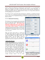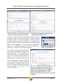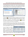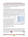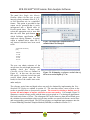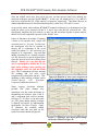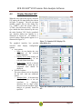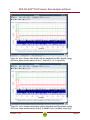
1
SC3-RAV™ 2015 User’s Reference Manual Version 15.0.1– June 2015 BCE SC3-RAV™ 2015 Seismic Data Analysis Software BCE’s mission is to provide our clients around the world with state-of-the-art seismic data acquisition and analysis systems, which allow for better and faster diagnostics of the subsurface. The company provides state-of-the-art hardware and software solutions for a wide variety of seismic engineering applications. If necessary, we will customize our products to suit the requirements of our clients even better. BCE's products and services consist of Seismic Data Acquisition and Signal Conditioning Hardware Seismic Data Processing Software Applied Seismology Consulting Services Seismic Data Processing Professional Seminars By publishing this manual we will hopefully provide a better understanding of downhole seismic testing and the role it can play in geotechnical investigations. Baziw Consulting Engineers Ltd 3943 West 32nd Avenue Vancouver B.C. Canada V6S 1Z4 url: www.bcengineers.com email: [email protected] © 1998 - 2015 Baziw Consulting Engineers Ltd.. All rights reserved. The content on this work is protected by the copyrights of Baziw Consulting Engineers Ltd.. No part of this document may be reproduced, stored in a retrieval system, or transmitted in any form or by any means, electronic, mechanical, photocopying, or otherwise without the prior written permission of Baziw Consulting Engineers Ltd. Although every precaution has been taken in the preparation of this manual, we assume no responsibility for any errors or omissions, nor do we assume liability for damages resulting from the use of the information contained in this manual Version 15.0.1 Page i BCE SC3-RAV™ 2015 Seismic Data Analysis Software ability to apply notch filter on harmonics within the Cascadable Filters enhanced display options when viewing seismic data and displaying standard VSPs or full waveform VSPs option to save or export user specified arrival times when displaying standard VSPs and to display previously saved arrival times when displaying standard VSPs incorporation of new function as part of the batch operation of the polarization analysis to classify the quality of the calculated interval velocity values. Version 15.0.1 Page ii BCE SC3-RAV™ 2015 Seismic Data Analysis Software Table of Contents List of Figures ............................................................................................................................. v Chapter 1 Introduction ...........................................................................................................i 1.1 What is SC3-RAV™? .....................................................................................................i 1.2 Organization of users manual........................................................................................ ii Chapter 2 Main Menu and Tool Bar ...................................................................................... 1 2.1 Introduction ................................................................................................................... 1 2.2 File Submenu Options ................................................................................................... 2 2.2.1 Convert SEG2 Data ................................................................................................... 2 2.2.1.1 Data Conversion on a File by File Basis ............................................................. 2 2.2.1.2 Data Conversion in Batch Mode......................................................................... 4 2.2.2 Convert Geotech AB Data ......................................................................................... 5 2.2.3 Convert Vertek Data .................................................................................................. 6 Chapter 3 Seismic Analysis .................................................................................................. 7 3.1 Calculate Interval Velocities .......................................................................................... 7 3.1.1 Crosscorrelation Technique ....................................................................................... 8 3.1.1.1 Analyze by Pairs ................................................................................................ 8 3.1.1.1.1 Automatic Processing ................................................................................. 9 3.1.1.1.2 Manual Processing.................................................................................... 12 3.1.1.2 Batch Job Analysis ........................................................................................... 16 3.1.2 Reverse Polarity Technique ..................................................................................... 19 3.1.3 Forward Modeling / Downhill Simplex Method....................................................... 20 3.2 Polarization Analysis ................................................................................................... 26 3.2.1 Incident Angle ......................................................................................................... 27 3.2.2 Polarization Analysis on an Individual Trace ........................................................... 28 3.2.3 Polarization Analysis in Batch Mode ....................................................................... 31 3.3 Attenuation Analysis ................................................................................................... 33 3.3.1 SCPT Absorption Analysis ...................................................................................... 36 3.3.1.1 Interval Analysis .............................................................................................. 37 3.3.1.2 Cumulative Analysis ........................................................................................ 37 3.3.2 Spectral Ratio Analysis ............................................................................................ 38 3.3.2.1 Equation Derivation ......................................................................................... 38 3.3.2.2 SC3-RAV Spectral Ratio Analysis .................................................................... 42 3.4 Data Stack ................................................................................................................... 46 3.5 Data Interpolation ........................................................................................................ 47 3.5.1 Inline Time Series Interpolation ............................................................................... 47 3.5.2 Save to File ............................................................................................................. 47 3.6 Signal Decay ............................................................................................................... 48 3.6.1 Individual Trace ...................................................................................................... 48 3.6.2 Batch Option ........................................................................................................... 49 3.7 Change Polarity ........................................................................................................... 50 3.8 Calculate Shear Modulus ............................................................................................. 50 Version 15.0.1 Page iii BCE SC3-RAV™ 2015 Seismic Data Analysis Software Chapter 4 View ................................................................................................................... 52 4.1 View Seismic Data ...................................................................................................... 52 4.2 Display Standard VSP ................................................................................................. 56 4.3 X-Y-Z-Full Waveform VSP Display............................................................................. 60 4.4 3D Display .................................................................................................................. 63 4.5 Display Interval Velocities ........................................................................................... 66 Chapter 5 Utilities .............................................................................................................. 68 5.1 Default GUI Settings ................................................................................................... 68 5.2 Sensor Type and Units ................................................................................................. 70 5.3 Full Waveform Component Specification .................................................................... 70 5.4 Sort SH Data Files and Create Working Directories ..................................................... 71 Chapter 6 Chart Formatting, Exporting, and Printing .......................................................... 72 Chapter 7 Window Submenu Options ................................................................................. 73 Chapter 8 Help Submenu Options ....................................................................................... 73 Appendix 1 - Baziw, E.J. 1993. Digital filtering techniques for interpreting seismic cone data. Journal of Geotechnical Engineering, Vol. 119 No. 6 ASCE. 98-1018....................................... 74 Appendix 2 - Baziw, E.J. 2002. Derivation of seismic cone interval velocities utilizing forward modeling and the downhill simplex method. Can. Geotech. J., vol. 39, pp.1-12. ........................ 75 Appendix 3 - SC1-RAV 2014 Installation Procedure ................................................................. 76 Appendix 4 - USB Flash Drive License Transfer Procedure ...................................................... 78 Appendix 5 - License Removal Procedure ................................................................................. 85 Version 15.0.1 Page iv BCE SC3-RAV™ 2015 Seismic Data Analysis Software List of Figures Figure 1: Main Menu and Tool Bar in SC3-RAV™ .....................................................................2 Figure 2: Geometrics’ SEG2 data file converter dialog box .........................................................2 Figure 3: SEG2 file input dialog box ...........................................................................................3 Figure 4: Output message for successful SEG2 data conversion ..................................................3 Figure 5: Geotech Data Conversion dialog box ...........................................................................5 Figure 6: Site Information dialog box ..........................................................................................5 Figure 7: Vertek data file converter dialog box ............................................................................6 Figure 8: Output message for successful Vertek data conversion .................................................6 Figure 9: Interval Velocities submenu with corresponding analysis options .................................7 Figure 10: Crosscorrelation Technique Interval Velocities dialog box ..........................................8 Figure 11: File Input dialog box ..................................................................................................8 Figure 12: Cascadable Filters dialog box .....................................................................................9 Figure 13: Illustration of high impact amplitudes and high bandwidth signals due to rod noise during a SCPT.............................................................................................................................9 Figure 14: Velocity, Cross-correlation Factor and Time Shift Estimates ..................................... 10 Figure 17: Typical output file .................................................................................................... 11 Figure 15: Save Velocity Data dialog box .................................................................................. 11 Figure 16: SCPT Site Information dialog box ............................................................................ 11 Figure 18: Start time speci-fication message dialog box ............................................................ 12 Figure 19: Graphically specifying the start time parameter ........................................................ 12 Figure 20: Three component seismic time series with corresponding frequency spectrum of the x component ................................................................................................................................ 13 Figure 21: Filtered X, Y, and Z component seismic traces for data files under study .................. 14 Figure 22: Superposition of filtered traces onto unfiltered seismic traces ................................... 14 Figure 23: Question box ............................................................................................................ 14 Figure 24: X component, Y component, Z component and Full-waveform (I) component crosscorrelation functions between filtered seismic traces shown in Figure 21. The maximum correlation value occurs at a time shift of 8.2 msec .................................................................... 14 Figure 25: Chart Editing & Printing dialog box ......................................................................... 15 Figure 26: Sensor Mapping user interface ................................................................................. 15 Figure 27: Batch Job Analysis dialog box .................................................................................. 16 Figure 28: Output after implementation of standard Batch Job Analysis .................................... 17 Figure 29: Estimating a reference arrival time of 48 ms at a vertical depth of 4.7 m .................. 17 Figure 30: Implementation of the LLSR technique and corresponding relative arrival times by enabling check box Enable Linear Least Squares Regression as outlined in Figure 10 ............... 18 Figure 31: Reverse Polarity Technique dialog box ..................................................................... 19 Figure 32: Graphical output from the Reverse Polarity Technique ............................................. 19 Figure 33: Main graphical interface screen in the FMDSM software option showing the Source Offset Parameters input tab ....................................................................................................... 20 Figure 34: FMDSM database interface illustrating inputted data for all available sites ............... 21 Figure 35: Database control buttons .......................................................................................... 22 Figure 36: Filtering DST site SCPTDemo ................................................................................. 22 Version 15.0.1 Page v BCE SC3-RAV™ 2015 Seismic Data Analysis Software Figure 37: Specifying a new DST FMDSM database ................................................................. 23 Figure 38: Filtering a newly created database (SCPTNew) with the initial entries illustrated ..... 24 Figure 39: FMDSM graphical screen after completion of the interval velocity........................... 24 Figure 40: Automatic insertion of the estimated interval velocities and corresponding error residuals into the FMDSM database .......................................................................................... 25 Figure 41: Source P, SV, and SH waves incident on seismic sensor............................................ 26 Figure 42: Defining output responses frame of reference: if the X and Y component responses are positive at the derived arrival time, the incident wave must reside in Quadrant III ..................... 27 Figure 43: Initial Polarization Analysis window ........................................................................ 28 Figure 44: Polarization Analysis with good linearity.................................................................. 28 Figure 45: Polarization Analysis with poor linearity .................................................................. 29 Figure 46: Rotation of source wave responses on the X, Y, and Z axes onto the full waveform axis ........................................................................................................................................... 30 Figure 47: Applying a 180° degree phase change on the wave shown in Figure 46 .................... 30 Figure 48: Batch Polarization dialog box ................................................................................... 31 Figure 49: DST system configuration for Interval and Cumulative attenuation analysis ............. 37 Figure 50: Spectral ratio vs. relative arrival time. ...................................................................... 41 Figure 51: Deriving interval Q with Spectral Ratio Cumulative Analysis ................................... 41 Figure 52: Berlage source wave with dominant frequency of 55 Hz and recorded at depth 5m... 42 Figure 53: Spectral Ratio Technique dialog box......................................................................... 42 Figure 54: Source Wave 2 (in blue) superimposed on Source Wave 1 (in red) without time offset ................................................................................................................................................. 43 Figure 55: Source Wave 2 (in blue) superimposed on Source Wave 1 (in red) with 32 ms time offset ......................................................................................................................................... 43 Figure 56: Output from Spectral Ratio Analysis (Interval analysis)............................................ 43 Figure 57: Output from Spectral Ratio Analysis (Interval analysis) with Coherency Factor of 0.6 ................................................................................................................................................. 45 Figure 58: Output from Cumulative Spectral Ratio Analysis...................................................... 45 Figure 59: Data Stack file input dialog box................................................................................ 46 Figure 60: Specifying the format to save stacked time series ..................................................... 46 Figure 61: Specifying the directory and file name of the stacked time series .............................. 46 Figure 62: User interface for Data Interpolation ........................................................................ 47 Figure 63: Apply Signal Decay submenu with corresponding analysis options .......................... 48 Figure 64: User interface for Signal Decay ................................................................................ 48 Figure 65: Example of applying the Signal Decay option to time series data with source wave multiples ................................................................................................................................... 48 Figure 66: User interface for Signal Decay (batch processing) ................................................... 49 Figure 67: VSP with a strong seismic response prior to the arrival of the SH wave .................... 49 Figure 68: VSP in Figure 67 after application of an Initial Time of 60 ms .................................. 50 Figure 69: VSP illustrated in Figure 67 after application of signal decay ................................... 50 Figure 70: Shear Modulus Calculation dialog box ..................................................................... 50 Figure 71: Typical interval mass density text file ....................................................................... 51 Figure 72: Calculation of the interval mass density when the interval velocity and mass density depth increments are not synchronized ...................................................................................... 51 Figure 73: Typical interval velocity output file from the Calculate Shear Modulus menu option 51 Version 15.0.1 Page vi BCE SC3-RAV™ 2015 Seismic Data Analysis Software Figure 74: Main graphical interface in View Seismic Data software option ............................... 52 Figure 75: Font dialog box ........................................................................................................ 54 Figure 76: Print Preview dialog box .......................................................................................... 54 Figure 77: Export dialog box ..................................................................................................... 54 Figure 78: Seismic trace in View Seismic Data software option ................................................. 55 Figure 79: Standard VSP Display File input dialog box ............................................................. 56 Figure 80: Standard VSP Profile graphical interface box ........................................................... 56 Figure 81: Filtered Standard VSP Display seismic trace profile ................................................. 57 Figure 82: Export Arrival Times dialog box ............................................................................... 58 Figure 83: Display of the PPA Values for the X-Component Time Series Data ........................... 59 Figure 84: Example of X-Y-Z-Full Waveform VSP Display Output where the X-component, Ycomponent, Z-component, and Full Waveform Seismic Time Series Data is Displayed ............. 60 Figure 85: Seismic Time Series Data Shown in Figure 84 with the Globally Normalization Option Enabled ......................................................................................................................... 61 Figure 86: Illustration of PPA Values for Captured Triaxial Data. In addition, the interval velocity between depths 2.0 m and 3.0 m is shown ................................................................................. 62 Figure 87: Typical 3D Display (data unfiltered) ......................................................................... 63 Figure 88: Typical 3D Display (same data as in Figure 87, but now filtered and chart copied to clipboard as described below) ................................................................................................... 64 Figure 89: 2D display of the FFT results of the filtered data shown in Figure 88 ....................... 64 Figure 91: Interval Velocities Display (incremental depth on the left, depth bars on the right) with corresponding accuracy for both compression and shear waves ................................................. 66 Figure 90: Interval Velocities dialog box ................................................................................... 66 Figure 92: Utilities Submenu ..................................................................................................... 68 Figure 93: Default GUI Settings ................................................................................................ 68 Figure 94: View->Seismic Data display with the Amplitude and Time default settings (Precision, Digits and Increment) set at 6, 3, 0.01 and 4, 2, 0.1, respectively. .............................................. 69 Figure 95: View->Seismic Data display with the Amplitude and Time default settings (Precision, Digits and Increment) set at 9, 9, 0.00001 and 6, 6, 0.00001, respectively ................................. 69 Figure 96: Sensor Type and Units dialog boxes ......................................................................... 70 Figure 97: Full Waveform Component Specification dialog box ................................................ 70 Figure 98: File selection dialog box ........................................................................................... 71 Figure 99: Chart Editing Dialog Box ......................................................................................... 72 Figure 100: Chart Printing Dialog Box ...................................................................................... 72 Version 15.0.1 Page vii BCE SC3-RAV™ 2015 Seismic Data Analysis Software Chapter 1 Introduction 1.1 What is SC3-RAV™? SC3-RAV™ is a Windows® program, which facilitates comprehensive Downhole Seismic Testing (DST) data reduction, analysis, and display. The user is provided with an extensive set of mathematical tools and patented algorithms to derive DST interval velocities and absorption values as well as to quantify vertical seismic profiles. In addition, SC3-RAV™ allows the review of frequency spectra, the comparison of both unfiltered and digitally filtered traces, and the plotting of interval velocity profiles. SC3-RAV™ also provides extensive chart editing, plotting, and exporting functionality. SC3-RAV™ includes the following features: Configurable for either geophones or accelerometers. Extensive frequency spectrum analysis. Bandpass, high pass, low pass, and notch digital filters. Polarization analysis. Quality assessment of estimated interval velocities. Ability to rotate the X, Y, and Z source wave responses onto a single full waveform axis. Ability to rotate the X, Y, and Z responses onto the P-SV-SH raypath coordinates. Seismic source wave incident angle estimation. Attenuation analysis and absorption estimation. Three independent velocity estimates for the X, Y, and Z components. Velocity estimate for the full waveform (i.e. incident wavelet, ρ = x2 + y2 + z2). Patented P-Wave and S-wave velocity estimation algorithm. Batch job processing. Source wave arrival time estimation. Linear least squares regression interval velocity estimation. Reverse Polarity Technique. Forward Modeling Downhill Simplex Method (FMDSM) in estimating interval velocities. Display of Vertical Seismic Profiles (VSPs) with trend line specification. Ability to save or export user specified arrival times when displaying standard VSPs. Display of peak particle accelerations, velocities, and displacements. 3D Displays of VSPs. Calculation of interval Gmax values. The ability to carry out data interpolation to increase the time series resolution. Post data stacking. Application of a signal decay function to minimize the effect of source wave multiples. Display of calculated interval velocities. Version 15.0.1 Page 1 BCE SC3-RAV™ 2015 Seismic Data Analysis Software 1.2 Organization of users manual The purpose of this manual is to instruct users of SC3-RAV™ in the use of the program by explaining its structure, taking the user step by step through the program menus, and specifying the use of interactive graphics and I/O routines. In addition, the manual contains the following items: Appendix 1 provides a copy of the paper entitled “Digital filtering techniques for interpreting seismic cone data.” This paper outlines the mathematical technique utilized in obtaining optimal crosscorrelation time shifts. Appendix 2 provides a copy of the paper entitled “Derivation of seismic cone interval velocities utilizing forward modeling and the downhill simplex method”. This paper outlines the mathematical algorithms utilized in the Forward Modeling and the Downhill Simplex Method (FMDSM). If required, BCE can also provide a thorough training course in the use of the SC3-RAV™ software package. Alternatively, the user can contact BCE to obtain a step-by-step instructional document that outlines the estimation of interval velocities utilizing the SC3-RAV™ software. The methods of analysis covered range from basic trend line estimation to more advanced patented cross-correlation techniques and iterative forward modeling. The user is also provided with an exercise document and associated seismic data set. Version 15.0.1 Page 2 BCE SC3-RAV™ 2015 Seismic Data Analysis Software Chapter 2 Main Menu and Tool Bar 2.1 Introduction SC3-RAV™ is a Windows® program utilizing time series analysis and interactive graphics for the purpose of estimating shear and pressure wave interval velocities as well as absorption Q values. The main menu of SC3-RAV™, as shown in Figure 1, has six different options: File Seismic Analysis (as described in Chapter 3 of this manual) View (as described in Chapter 4 of this manual) Utilities (as described in Chapter 5 of this manual) Window (as described in Chapter 7 of this manual) Help. The desired option is chosen either by moving the mouse over the desired option and pressing the left hand mouse button, by pressing function <F10> on the keyboard and selecting the desired highlighted option, or by pressing the corresponding underlined menu item letter on the keyboard. The program can also be operated by clicking on icons. illustrated in Figure 1, consists of 23 different icons: Convert data into SC3-RAV™ format Calculate Interval Velocity Apply Polarization Analysis Apply Attenuation Analysis Apply Data Stack Apply Data Interpolation Apply Signal Decay Change Polarity Calculate Shear Modulus View Seismic Data Display Standard VSP Display X-Y-Z Full Waveform 3D Display Display Interval Velocities Default GUI Settings Specify Sensor Type and Units Specify Full Waveform Component Sort SH Data Files and Create Working Directories Version 15.0.1 The toolbar of SC3-RAV™, as Page 1 BCE SC3-RAV™ 2015 Seismic Data Analysis Software Cascade Tile Horizontally Tile Vertically About Open User’s Manual Figure 1: Main Menu and Tool Bar in SC3-RAV™ 2.2 File Submenu Options The File option provides the user with 4 options: Convert SEG2 Data Convert Geotech AB data Convert Vertek data Exit 2.2.1 Convert SEG2 Data The Convert SEG2 Data option currently allows the user to select a set of SCPT data files acquired with a standard Geometrics triaxial system and to convert them into the SC3-RAV™ data format for processing. This conversion can be performed on a file by file basis or in batch mode. 2.2.1.1 Data Conversion on a File by File Basis The conversion process on a file by file basis is as follows: 1. specify the set of files to be converted by clicking on the Specify Files button, which opens a File Input dialog box as shown in Figure 3. 2. optionally, enter/update desired site information by selecting the Site Info Specification button (see Figure 6). Figure 2: Geometrics’ SEG2 data file converter dialog box Version 15.0.1 Page 2 BCE SC3-RAV™ 2015 Seismic Data Analysis Software 3. specify the SEG2 channel format ((X,Y,Z) or (Z,Y,X) for a 3 channel system and (X1,X2,Y1,Y2,Z1,Z2) or (Z1,Y1,X1,Z2,Y2,X2) for a 6 channel system); for a 6 channel system the user also specifies whether the converted data at Datum 1 (Z1,Y1,X1) or Datum 2 (Z2,Y2,X2) is saved to file. 4. specify for the file set: Source Radial Offset [m] Source Radial Depth [m] File Type (i.e. ASCII or binary) The values for Source Radial Offset and Source Radial Depth are saved within the SC3-RAV™ ini file and become default values for these parameters on a subsequent execution of the SC3-RAV™ program. 5. specify for each file (by polling the selected data files forward and Figure 3: SEG2 file input dialog box backward using the and , buttons respectively) the following data: Probe Depth [m] – the user has the option to either enter the probe depth directly or change the current value by the user defined Depth Increment by clicking on the or button Polarization (i.e. Right, Left or None). 6. convert each individual file into the SC3-RAV™ data file format by clicking button . The program then copies the converted SEG2 data files into a subdirectory (ASCII or Binary, depending on the selected file type) that is created in the same directory as the original SEG2 files. The converted data files are named as the SEG2 file to be converted but appended as follows: the acquisition depth is inserted at the end of the file name along with the user specified polarity. extension ‘aci’ is utilized for SEG2 files converted to ASCII format while extension ‘bin’ is utilized for SEG2 files converted to binary format. For example, SEG2 file 1003.DAT is renamed as 1003_1_500R.aci for an ASCII file conversion for a trace recorded at a depth of 1.5m and having Right Polarity. 7. if the conversion has been successful the output message shown in Figure 4 appears. Alternatively an error message is shown and a text file (StdErr_converter.txt) is created in the SEG2 data file directory with the error messages that were generated in the conversion process. 8. this process is repeated until all files have been processed, after Figure 4: Output which the user clicks on the Close button. message for successful SEG2 data conversion Version 15.0.1 Page 3 BCE SC3-RAV™ 2015 Seismic Data Analysis Software 2.2.1.2 Data Conversion in Batch Mode In the SEG2 batch conversion process it is assumed that the files are time stamped synchronously with each subsequent depth increment. However, the program allows not only file sets that start at the surface (which each subsequent file taken at a greater depth), but also sets that start at depth (which each subsequent file taken at a shallower depth). The conversion process in batch mode is as follows: 1. in data file converter dialog box (see Figure 2) enable check box Enable. 2. in the same dialog box specify whether the DST investigation starts at depth (enable check box Decrement Depth) or at surface (disable check box Decrement Depth). 3. optionally, enter/update desired site information by selecting the Site Info Specification button (see Figure 6). 4. specify for the file set: Source Radial Offset [m] Source Radial Depth [m] File Type (i.e. ASCII or binary) The values for Source Radial Offset and Source Radial Depth are saved within the SC3-RAV™ ini file and become default values for these parameters on a subsequent execution of the SC3-RAV™ program. Polarization (i.e. Right, Left or None). starting Probe Depth [m] and corresponding Depth Increment [m]. 5. specify the set of files to be converted by clicking on the Specify Files button, which opens a File Input dialog box as shown in Figure 3. It should be noted that all files should have the same polarity (i.e., Right, Left or None) and be associated with the same test hole. 6. if the SEG2 batch conversion has been successful the output message “SEG2 File Batch Conversion Completed” appears. Version 15.0.1 Page 4 BCE SC3-RAV™ 2015 Seismic Data Analysis Software 2.2.2 Convert Geotech AB Data The Convert Geotech AB Data option allows the user to select a set of SCPT data files acquired with a standard triaxial Geotech AB system and to convert these into the SC3RAV™ data format for processing as follows: 1. optionally, enter/update desired site information by selecting the Site Info Specification button (see Figure 6). Figure 5: Geotech Data Conversion dialog box 2. specify the set of files to be converted by clicking on the Specify Files button, which opens a File Input dialog box as shown in Figure 3. 3. click on Open button at the bottom of this dialog box to convert each individual file into the SC3-RAV™ data file format. The program then copies the converted Geotech data files into subdirectory ..\ BCE FORMAT that is created in the same directory as the original. The converted data files have extension ‘_BCE’ appended to the original file name. Figure 6: Site Information dialog box Version 15.0.1 Page 5 BCE SC3-RAV™ 2015 Seismic Data Analysis Software 2.2.3 Convert Vertek Data The Convert Vertek Data option allows the user to select a set of SCPT data files acquired with some Vertek triaxial systems and to convert these into the SC3-RAV™ data format for processing as follows: 1. optionally, enter/update desired site information by selecting the Site Info Specification button (see Figure 6). 2. specify the set of files to be converted by clicking on the Specify Files button, which opens a File Input dialog box as shown in Figure 3. 3. specify for the file set: Figure 7: Vertek data file converter dialog box Source Radial Offset [m] Source Radial Depth [m] File Type (i.e. ASCII or binary) The values for Source Radial Offset and Source Radial Depth are saved within the SC3-RAV™ ini file and become default values for these parameters on a subsequent execution of the SC3-RAV™ program. specify for each file (by polling the selected data files forward and backward using the and buttons respectively) the Polarization (i.e. Right, Left or None) 4. convert each individual file into the SC3-RAV™ data file format by clicking button . The program then copies the converted Vertek data files into a subdirectory (ASCII or Binary, depending on the selected file type) that is created in the same directory as the original Vertek files. The converted data files are named as the Vertek file to be converted but appended as follows: the acquisition depth is inserted at the end of the file name along with the user specified polarity. extension ‘aci’ is utilized for Vertek files converted to ASCII format while extension ‘bin’ is utilized for SEG2 files converted to binary format. For example, Vertek file Z29O1302S.001 is renamed as Z29O1302S_1_0799R.aci for an ASCII file conversion for a trace recorded at a depth of 1.0799m and having Right Polarity. 5. if the conversion has been successful the output message shown in Figure 8 appears. Alternatively the error message “'Error in Data Conversion'” is shown. 6. this process is repeated until all files have been processed, after which the user clicks on the Close button. Figure 8: Output message for successful Vertek data conversion Version 15.0.1 Page 6 BCE SC3-RAV™ 2015 Seismic Data Analysis Software Chapter 3 Seismic Analysis The Seismic Analysis1 menu option allows the user to process acquired seismic traces so that important geotechnical design parameters are obtained. As shown in Figure 9, this menu has eight different options: Calculate Interval Velocities Apply Attenuation Analysis Apply Polarization Analysis Apply Data Stack Apply Data Interpolation Apply Signal Decay Change Polarity Calculate Shear Modulus Figure 9: Interval Velocities submenu with corresponding analysis options In this menu the user specifies the desired option by selecting the appropriate graphical tabs or corresponding toolbar icon. 3.1 Calculate Interval Velocities When selecting the Calculate Interval Velocities option in the Seismic Analysis menu, a submenu as shown in Figure 9 appears. This submenu allows the user to select one of three available algorithms to derive Downhole Seismic Testing (DST) interval velocities: the Crosscorrelation Technique the Reverse Polarity Technique the Forward Modeling Downhill Simplex Method (FMDSM). When using the Crosscorrelation Technique or the Reverse Polarity Technique it may be advantageous to first rotate the source wave responses onto the full waveform axis or onto the raypath coordinate axes (as described in Section 3.2 - Polarization Analysis). 1 The Sensor Type (geophone or accelerometer) should be specified prior to the implementation of the options under Seismic Analysis. Section 5.2 outlines the Sensor Type menu and corresponding interface. Version 15.0.1 Page 7 BCE SC3-RAV™ 2015 Seismic Data Analysis Software 3.1.1 Crosscorrelation Technique The Crosscorrelation Technique implements a patented mathematical algorithm to derive DST interval velocity profiles based on cross-correlating the wave recorded at consecutive depth increments (Baziw 1993). The value of the time shift at the maximum crosscorrelation value is assumed to be the relative travel time difference for the wave to travel the depth increment. This technique has the following advantages over the standard Reverse Polarity Technique: it minimizes the human bias associated with visually selecting a crossover point in deriving interval times which is required by the reverse polarity technique. it utilizes the full waveform in deriving Figure 10: Crosscorrelation Technique interval travel times as opposed to a single Interval Velocities dialog box point. the correlation coefficient between the two waves gives the user an indication of the similarity between the two waves being correlated and the subsequent accuracy of the velocity estimate. Note: Enabling check box Enable Data Interpolation enhances the resolution of the optimized correlator by utilizing linear interpolation between digitally sampled points, guaranteeing a minimal time resolution of 0.01 ms (equivalent sampling rate of 100 KHz). it obtains two independent velocity estimates for each depth increment by comparing source wave generated on both the right and left side of the seismic probe. Figure 10 shows the dialog box which appears when the Crosscorrelation Technique analysis option is selected. 3.1.1.1 Analyze by Pairs The Analyze by Pairs option under the Crosscorrelation Technique refers to processing two seismic traces at a time at different depth increments in order to derive the seismic interval velocities. Referring to Figure 10, running this option requires the specification of the input file at depth 1 and another file at Figure 11: File Input dialog box depth 2. Version 15.0.1 Page 8 BCE SC3-RAV™ 2015 Seismic Data Analysis Software Figure 11 illustrates the dialog box for inputting these seismic data files. It is very important that these files correspond to the depths of penetration where depth2 is greater than depth1. In addition, the sampling rate for the two traces must be the same and they should both be equivalently polarized. However, enabling check box Depth (1-2): Change Polarity allows for inverting (flipping) data in a specific file. The Analysis by Pairs can be done either Automatically or Manually, as explained in Sections 3.1.1.1.1 and 3.1.1.1.2 respectively, and the user should specify the desired processing method. Once the seismic files are inputted and the type of analysis is specified, the Begin Processing button is selected. 3.1.1.1.1 Automatic Processing The Automatic Processing option refers to processing the in-situ seismic data without displaying frequency spectra and filtered traces. This option saves substantial computing time, but is only applicable if the user has insight into the frequency spectrum of the seismic waves of interest. It will use the sampling rate specified when the data is acquired, and will automatically reduce the seismic traces, calculate and display the corresponding velocity, accuracy and relative time shift. When the Process Data button is selected the Cascadable Filters dialog box appears (see Figure 12). The cascadable filters are digital zero phase shift eighth order bandpass, notch, high, and low pass frequency filters. The user enables a filter by checking the Enabled box and specifying the appropriate frequency or frequencies (see b below). a. Specify Start Time (T0) The Start Time parameter refers to removing seismic responses dominated by high impact amplitudes and high bandwidth signals traveling down the borehole or seismic cone (SC) rods. This phenomenon can occur if the seismic source is close to the borehole or SC rods. Figure 13 illustrates this high impact energy phenomenon. It is sometimes not possible to filter these high impact signals with digital filters alone, and therefore the user is instructed to specify the time after impact signal so that these responses can be removed prior to digital filtering. For example, referring to Figure 13 the user would Version 15.0.1 Figure 12: Cascadable Filters dialog box Figure 13: Illustration of high impact amplitudes and high bandwidth signals due to rod noise during a SCPT Page 9 BCE SC3-RAV™ 2015 Seismic Data Analysis Software specify a T0 value of approximately 25 ms. b. Specify Filter Parameters The program offers four different types of digital frequency filters: Bandpass Filter, where the user specifies the desired upper and lower cut-off frequencies. Notch Filter, where the user specifies the desired notch frequency Low Pass Filter, where the user specifies the desired low pass frequency. High Pass Filter, where the user specifies the desired high pass frequency In each of these cases, default values, which are good starting points for inexperienced users, have already been entered, but these values can obviously be changed. Generally, the only frequency filter required is either the bandpass filter or the low pass filter. For the bandpass filter both the low pass and high pass frequency must be specified to define the bandpass that isolates the seismic wave being reviewed. Typically, these values are set at 30 Hz and 120 Hz to 140 Hz, respectively for a SH-wave analysis. For the low pass filter the cutoff frequency is normally set between 120 and 140 Hz. The notch filter option is provided so that the user may remove unwanted frequencies, such as those due to power supplies (e.g. 60 or 120Hz) or electrical transmission line effects (and by checking the Remove Harmonics box the program will also remove frequencies equal to double and triple the frequency specified from the seismic trace). If the band of frequencies desired is too narrow or wide, then a set of cascadable low pass and high pass frequency filters can be utilized. Next the user implements the specified filter parameters by checking the Enabled box and then pressing the OK button located at the bottom center of the Cascade Filters dialog box. c. Calculate Velocity, Accuracy, and Relative Arrival Time Estimates Once the OK button has been pushed, the program provides the user with the velocity, crosscorrelation factor and relative arrival time estimates for each of the three wave components (X, Y, and Z) as well as the full or incident waveform time series as shown in Figure 14. The relative arrival time estimates can subsequently be utilized within the FMDSM technique described in Section 3.1.3. The user can re-specify the calculated Time Shifts for the output of Automatic Interval Velocities and Manual Interval Velocities (by overwriting the values in the table shown in Figure 14) and subsequently re-calculate the interval velocities by selecting the calculator push button shown at the bottom of Figure 14. The Cross-Correlation Function (CCF) factor gives an indication of how closely the correlated filtered seismic traces resemble each other and the reliability of the subsequent velocity estimate. The value of the CCF factor is between 0.0 to 1.0, and should be as close to 1.0 as possible. Values above 0.85 are recommended for the hammer shear source (i.e., SH-wave source). Version 15.0.1 Figure 14: Velocity, Cross-correlation Factor and Time Shift Estimates Page 10 BCE SC3-RAV™ 2015 Seismic Data Analysis Software d. Store Data Storing the results can be done by pushing the button with the Data Storage icon shown at the center bottom of Figure 14. If the user decides to do so a window opens as shown in Figure 15, in which the name of the output file can be defined by pressing icon or manually specifying the output file within the text box provided. If necessary, site information can be added or amended by clicking on the Site Info Specification button, which opens the window shown in Figure 16. Figure 15: Save Velocity Data dialog box After the Output File has been specified the user selects push buttons Save or Re-write. If the user selects button Re-write and the file already exists, then the file will be re-written with the newly processed data. If the Save button is selected and the output file already exists, the velocity estimates will be appended to the data file. Figure 17 shows a typical output data file. Depending on which filters are enabled, the applicable filter frequencies are stored within the output file. Figure 16: SCPT Site Information dialog box 2015 Project Name: annual \ ProjectNumber: 001 \ Client: BCE Test Number: 1 \ Location: Vancouver office \ Site Operator: GV \ Site Date: 6/26/2015 11:21:43 AM Coordinate System: N/A \ Coordinate X: N/A \ Coordinate Y: N/A Reference Level: N/A \ Water Level: N/A \ Ground Level: N/A Velocity (m/sec) Type Depth1 (m) Depth2 (m) X: 102.10 Y: 103.29 Z: 105.34 S S S 24.00 25.00 26.00 25.00 26.00 27.00 Accuracy Bandpass (Hertz) 0.99422 30.0 to 100.0 0.97332 30.0 to 100.0 0.98532 300 to 100 TS (ms) 8.1 7.8 8.5 Figure 17: Typical output file Version 15.0.1 Page 11 BCE SC3-RAV™ 2015 Seismic Data Analysis Software 3.1.1.1.2 Manual Processing The Manual Processing option is a more detailed analysis of the in-situ seismic traces. In this option, a start time is specified if desired, the inputted waves are then analyzed for frequency content, after which the filtered and unfiltered traces are displayed in order to decide whether the correct seismic waves were isolated. Finally the crosscorrelation function is displayed followed by the velocity, accuracy and time shift estimates. In the Manual Processing option the seismic traces are more thoroughly analyzed with interactive graphics. These graphics facilitate choosing the proper frequency filters to be used in the Automatic Filtering and Batch Processing options. For illustrative purposes, an example of data processed with SC3-RAV™ using the Manual Processing option will be presented. In this example data files Ds4.aci and Ds7.aci are analyzed, and the relevant parameters describing these digital seismic traces are as follows: TriaxR4.aci: Sampling rate: 0.1 ms Depth: 2.7 m X offset: 2.1 m Y offset: 0.0 m TriaxR7.aci: Sampling rate: 0.1 ms Depth: 3.7 m X offset: 2.1 m Y offset: 0.0 m The message shown in Figure 18 appears when the user selects the Process Data button in the Crosscorrelation Technique dialog box (see Figure 12) with the Manual Processing option enabled. By selecting push button Yes in Figure 18 the output illustrated in Figure 19 appears; if push button No is selected, the program will move to the Spectral Analysis as shown in Figure 20. In Figure 19 the seismic traces (x, y and z axes) to be analyzed (i.e., triaxR4.aci) are displayed. The crosshair displayed in chart window is moved around by the mouse, with the corresponding time displayed in ms at the top of the chart. The time window can be zoomed into a desired range by pressing the left mouse button and moving the mouse left to right. The seismic traces are shifted left to right by pressing the right mouse button and moving the mouse. The user can zoom out again by pressing the left mouse button and moving the mouse right to left. The start time, T0, is selected by pressing the middle mouse button or <Shift> + right or left mouse buttons. The selected Start Time T0 can be cleared by double clicking on the left mouse button. The grey chart spacer allows the user to expand or Version 15.0.1 Figure 18: Start time specification message dialog box Figure 19: Graphically specifying the start time parameter Page 12 BCE SC3-RAV™ 2015 Seismic Data Analysis Software contract the individual charts as desired. Once the start time has been defined by clicking on the OK button at the top left of Figure 19 the program will move to the Spectral Analysis as shown in Figure 20. In Figure 20 the x, y and z component of the seismic trace to be analyzed (i.e. TriaxR4.aci) are shown. The cross-hair displayed in the frequency spectrum and time series is moved around by the mouse, with the corresponding frequency and time displayed above the charts. The frequency spectrum and time series can be zoomed into a desired range by pressing the left mouse button and moving the mouse left to right. Figure 20: Three component seismic time series with corresponding frequency spectrum of the x component The user has the capability to apply a time window on the seismic wave so that the frequency bandpass parameters can be better selected. The time window is specified by moving the crosshair in the time domain window and selecting the times (by pressing the mouse middle button or <Shift> + right or left mouse buttons) which incorporate the desired wave (note : T1 < T2). After the time window has been specified, the user specifies which component frequency spectrum is to be calculated and displayed by selecting the appropriate radio button under FFT Type. The user then clicks the FFT button so that the specified component’s time window frequency spectrum is calculated and displayed. The selected time window can be cleared by double clicking on the left mouse button. The frequency spectrum display includes a graphical panel which allows the user to specify the necessary digital filters to apply to the seismic time series under study. The digital filter implementation is identical to that outlined for the Cascadable Filter dialog box. The user can enable a bandpass filter by enabling check box Bandpass Filter. The frequency bandpass is selected by pressing the middle mouse button or <shift> + right or left mouse button for each frequency in the bandpass (ie., F1 < F2). Figure 20 illustrates the frequencies selected by the characters F1 and F2. The Notch, Low Pass and High Pass Filters are enabled by checking the appropriate check boxes and specifying the notch, low pass and high pass frequencies, respectively. Once the user has interactively defined the digital filter parameters and has repeated the process for the other seismic trace under study, the three filtered component seismic traces are displayed as is illustrated in Figure 21. The user may superimpose the filtered onto the unfiltered traces by selecting check box Unfiltered Traces as is illustrated in Figure 22. Version 15.0.1 Page 13 BCE SC3-RAV™ 2015 Seismic Data Analysis Software Figure 21: Filtered X, Y, and Z component seismic traces for data files under study Figure 22: Superposition of filtered traces onto unfiltered seismic traces Once the user quits this display, a question box appears (as shown in Figure 23) and the user is asked whether he wants to re-filter the seismic traces. If the Yes push button is selected, then the previously outlined procedure is repeated (i.e., re-specifying the frequency bands). The reason for re-filtering should be apparent from the wave signatures. If the filtered waves appearing in Figure 21 are substantially different, one or both should be refiltered so as to find waves with similar signatures. Figure 23: Question box If re-filtering is not required, the two filtered traces will be crosscorrelated and the crosscorrelation factors will be displayed as illustrated in Figure 24. The highest positive value in the crosscorrelation function is indicative of the time offset between the seismic traces. Once the user exits the crosscorrelation plot, the velocity, depth and accuracy of the interval velocity estimate are then displayed as outlined in Figure 14, and the user is prompted whether he would like to store estimates in a data file as was Figure 24: X component, Y component, Z described in Figure 15. component and Full-waveform (I) component crosscorrelation functions between filtered seismic traces shown in Figure 21. The maximum correlation value occurs at a time shift of 8.2 msec Version 15.0.1 Page 14 BCE SC3-RAV™ 2015 Seismic Data Analysis Software The edit button displayed at the top left hand corner of the previously illustrated graphs allows for chart formatting, printing, and exporting. Figure 25 shows the interface box that appears when the edit button is selected. This box allows for extensive modification of the displayed data and chart attributes, as well as the print settings. This interface box has an extensive electronic help function that can be accessed by selecting the help button in this box. Figure 25: Chart Editing & Printing dialog box The user can also save the modified chart templates by selecting the Save Chart Settings button (middle button on the top left corner of the Crosscorrelation Function screen). Once this button has been selected, a configuration file containing the template information is stored in subdirectory ..\SC3-RAV\chartCFG.. When SC3-RAV™ is reopened, the user may reload the chart template by selecting the Load Chart Settings button (right button on the top left corner of the Crosscorrelation Function screen). The chart formatting, printing, and exporting functionality is provided for all charts displayed within SC3-RAV™. In the previously outlined Analyse by Pairs analysis techniques (whether automatic or manual) it is preferable to first utilize the Polarization Analysis technique to rotate responses on the X, Y, and Z axes onto one full waveform axis. This rotation may not be possible due to latency effects between the X, Y, and Z responses, and in that case the user may want to obtain relative time shifts by cross-correlating the X and Y, Y and Z, and X and Z seismic time series between successive depths using the Sensor Mapping option. The Sensor Mapping user interface is enabled by selecting the Sensor Mapping button shown in Figure 10. Figure 26 illustrates the Sensor Mapping user interface. For each depth increment (i.e., depth1 and depth2) the user selects the appropriate radio button which maps the Depth1 axis responses with the Depth2 axis responses. For example, if the investigator Figure 26: Sensor Mapping user interface wanted to correlate the Depth1 X axis Version 15.0.1 Page 15 BCE SC3-RAV™ 2015 Seismic Data Analysis Software response with the Depth2 Y axis response, then radio button Depth 2: Y Axis would be enabled under radio group Depth1: X axis Mapping. The calculated interval velocities would correspond with the Depth1 axis responses (e.g., X: interval velocity would be associated with the crosscorrelation of Depth1 X axis response and Depth2 Y axis response). 3.1.1.2 Batch Job Analysis The Batch Job Analysis option outlined in Figure 10 facilitates the user to process many seismic traces with similar filter parameters in a batch mode. In addition, Batch Job Analysis allows for the estimation of the arrival times for each depth increment and the implementation of Linear Least Squares Regression (LLSR) to derive interval velocities, which minimizes the variability of the interval velocities. The LLSR utilizes three adjacent crosscorrelated relative arrival times, the corresponding time series depth and a reference arrival time and depth to determine the slope of the best fitting line through the three points. The slope of the best fitting line is then defined as the interval velocity. In other words, the LLSR applies linear regression on three depth adjacent source waves (e.g., 7m, 8m, and 9m) within a vertical seismic profile (arrival time vs depth plot) so that smoothed interval velocity estimates are obtained. In the standard application of Batch Job Analysis the user selects push button Begin Processing in the screen shown in Figure 10. The file input dialog box shown in Figure 27 then appears. The user can input multiple seismic files in this dialog box (i.e., <SHIFT> plus left mouse click or <CTRL> plus left mouse click), but these files should be related (i.e., either all from the right or the left side) and have corresponding incremental depths. The program automatically sorts the traces Figure 27: Batch Job Analysis dialog box according to their respective depths. The user then specifies the appropriate filter parameters and selects the OK button from the Cascadable Filters dialog box. Upon data processing completion, the program displays the average depths, the calculated velocities in each direction as well as the incident or full waveform interval velocities (V) together with the corresponding accuracies (ϕ), and relative arrival times (TS) as is shown in Figure 28. The user can save these results to file (eg., for later Interval Velocity profiling) by putting check marks next to the values to be saved (all the results can be selected automatically be selecting the red check button ) and selecting the graphical store data push button in panel Batch Job Results. Version 15.0.1 Page 16 BCE SC3-RAV™ 2015 Seismic Data Analysis Software The panel Save Single Axis Velocity Estimate allows for the user to save interval velocity estimates of the X, Y, Z, or Full Waveform axis in a simplified format. This option is provided so that output can be generated that is easily incorporated into a Word® table or Excel® spread sheet. The user simply selects the appropriate axis to store and then the store data push button which facilitates specification of the single axis velocity filename. A typical output is outlined below where the X axis interval velocities have been saved to file. Figure 28: Output after implementation of standard Batch Job Analysis X Axis Interval Velocity [m/s] 104.430 111.340 163.660 113.270 123.510 ... The user can obtain estimates of the arrival times for each depth increment by enabling check box Display and Calculate Arrival Times as outlined in Figure 10. In this case, the user must first specify a reference arrival time and vertical depth (based upon the first break) for one of the seismic time series under analysis. Figure 29: Estimating a reference arrival time of 48 ms at a vertical depth of 4.7 m The reference arrival time and depth values can easily be obtained by implementing the View Standard VSP Display as outlined in section 4.2. The user then selects a trace as near to the surface as possible where a clear arrival is present. The reason for selecting a shallow trace is because the main impact of surface refraction occurs near surface. For example, Figure 29 illustrates a vertical seismic profile with the time series acquired at 4.7 m having an approximate first break arrival time of 48 ms. The subsequent DST arrival times are then derived based upon the calculated crosscorrelation relative arrival times and the user specified reference arrival time and corresponding vertical depth. The DST arrival times are important input parameters into the Forward Modeling Downhole Simplex Method (FMDSM) as outlined in Section 3.1.3. Version 15.0.1 Page 17 BCE SC3-RAV™ 2015 Seismic Data Analysis Software The panel Arrival Time Saving and Exporting allow for the user to save estimated arrival times and exporting to the FMDSM database. As illustrated in Figure 30, the Estimated Arrival Times can be saved by selecting the appropriate radio button (X Axis, Y Axis, Z Axis or All Axes) followed by selecting button . The All Axes option saves the estimated arrival times from the X, Y, Z and Full Waveform Axis to the user specified file. The ability to export the estimated arrival times to the FMDSM database provides significant post processing time saving. The SC3-RAV™ software Figure 30: Implementation of the LLSR technique either extracts the Site Name from a and corresponding relative arrival times by SC3-DAC™ file (based on the SC3- enabling check box Enable Linear Least Squares DAC™ automatic file naming Regression as outlined in Figure 10 convention) or, if an alternative acquisition system is utilized, the investigator is required to manually input the desired Site Name within the text box provided (the default entry for this field is “SCPT”). By clicking on Button the estimated arrival times are exported to the FMDSM database. Note that user interface radio button options X Axis, Y Axis, Z Axis and All Axes allow for copying the X Axis, Y Axis, Z Axis and Full waveform Axis arrival times, respectively. When exporting the data the user can select from two options. When option Overwrite Record is selected (which is also the default setting) data previously stored in the database are overwritten and the new data are stored in the FMDSM database with measurement weights set to 1. However, in a typical SH-wave FMDSM analysis procedure the first arrival time estimates exported are estimates obtained from “right side” (seismic traces acquired from the “right side“ of the seismic probe) full seismic waveforms (i.e., Polarization Analysis applied with full waveforms mapped onto the X axis (see Section 3.2)). Next the estimated “left side” arrival times should be exported to the FMDSM database. By selecting the option Average Record selected the estimated arrival times from the “right side” (already in the database) and “left side” will be averaged and stored in the FMDSM database with measurement weights set to 1. Version 15.0.1 Page 18 BCE SC3-RAV™ 2015 Seismic Data Analysis Software 3.1.2 Reverse Polarity Technique The Reverse Polarity Technique dialog box is illustrated in Figure 31. In this option the user specifies four seismic data files to be processed outlined as follows: 1. Polarized Files at Depth1 - The user selects two files which correspond to reversely polarized waves acquired at the same depth - Depth1. 2. Polarized Files at Depth2 - The user selects two files which correspond to reversely polarized waves acquired at the Figure 31: Reverse Polarity Technique same depth - Depth2. dialog box It is required that Depth2 is greater than Depth1. The user can make the required selections by pressing the left mouse button together with the <CTRL> or <Shift> key. Once the above data files have been specified, the user then selects the OK push button, after which the program will ask the user to specify, if applicable, the filtering parameters for the data files selected. Once the traces are filtered, if necessary, the seismic traces are displayed as is illustrated in Figure 32. The user is required to select interactively (i.e., with the mouse) the crossover point at depth1 (i.e., T1) and the crossover point at depth2 (i.e., T2). The crosshair is moved to the desired crossover point and the middle mouse button or <Shift>+right or left mouse button is selected. The crossover point selection can be cleared by double clicking the left mouse button. The user selects the Calculator icon to determine the velocity (with travel path corrections) corresponding to the crossover times selected. The calculated velocity is displayed at the bottom of the chart as is illustrated in Figure 32. The user may then save this information in a velocity file (by Figure 32: Graphical output from the Reverse selecting ) as previously described. Polarity Technique This allows for easier interval velocity comparisons between Reverse Polarity and Crosscorrelation techniques. Version 15.0.1 Page 19 BCE SC3-RAV™ 2015 Seismic Data Analysis Software 3.1.3 Forward Modeling / Downhill Simplex Method The Forward Modeling / Downhill Simplex Method (FMDSM) utilizes seismic ray tracing and optimal estimation techniques to derive DST interval velocities. The standard techniques implemented to determine DST interval velocities rely upon obtaining reference P and S wave arrival times as the probe is advanced into the soil profile. By assuming a straight ray travel path from source to seismic receiver and calculating relative reference arrival time differences, interval DST velocities are obtained. The FMDSM offers distinct advantages over conventional DST velocity profile estimation methods, such as: utilization of Snell’s Law at layer boundaries for ray path refraction. optimization of a non-linear cost function, which takes into account more details of the DST testing environment and the recorded seismic data. allowance for measurement weights to be specified, the possibility to incorporate unlimited input data (e.g., crossover point arrival times, maximum cross-correlation time shifts, angles of incidence and P-wave / S-wave time separations) into the interval velocity estimation algorithm. ability to accurately interpolate interval velocities when measurement data are not available. reporting of meaningful error residuals, which indicate the accuracy of the estimated interval velocity. Please refer to Appendix 2 for further details and the ability of the FMSDM to obtain variable interval velocity estimates. In the FMDSM the user is provided with a user friendly interface to specify seismic wave arrival times with corresponding weights within a Windows® compatible database. This information is derived from implementing SC3-RAV™ menu options Crosscorrelation Technique->Batch Job Analysis with Display and Calculate Arrival Times option enabled. The graphical screen illustrated in Figure 33 appears when the FMDSM menu option is selected. Version 15.0.1 Figure 33: Main graphical interface screen in the FMDSM software option showing the Source Offset Parameters input tab Page 20 BCE SC3-RAV™ 2015 Seismic Data Analysis Software The first step in implementing the FMDSM is for the user to specify important parameters: Radial: The radial offset of the DST source from the seismic receiver. Depth: The depth offset of the DST source from the ground surface. Once these parameters have been specified, the user must either generate or select a database which contains the required DST arrival times. This step is carried out selecting the Database icon , after which the graphical database interface illustrated in Figure 34 appears. At the top of the interface there are ten buttons with which the user manipulate the database: Figure 34: FMDSM database interface illustrating inputted data for all available sites + move to the beginning of the list move one record back move one record forward move to the end of the list insert record Version 15.0.1 ✓ X delete record edit a record post record undo edit update list Page 21 BCE SC3-RAV™ 2015 Seismic Data Analysis Software In addition there are one icon, 4 buttons and one checkbox at the bottom of the interface: the Process Selected Site Data icon initiates the FMDSM analysis. the Filter Selected Site button allows the user to filter the arrival time information Figure 35: Database control buttons for a specific site by highlighting that site within the scroll list of available sites (on bottom of the user interface window). The filtered arrival time information for site SCPTDemo is illustrated in Figure 36. the Show All Sites button allows the user to undo previous data filtering. the Delete Selected Site button allow the user to delete a specific site by highlighting that site within the scroll list of available sites (on bottom of the user interface window). The Export IV for Selected Site button allows the user to export the estimated FMDSM interval velocities (IV) for a specific site by highlighting that site within the scroll list of available sites (on bottom of the user interface window). When button is clicked a dialog box to enter specific test information appears as was outlined in Figures 15 and 16. Alternatively, if checkbox Save as Text File is checked then the FMDSM interval velocities are saved in a simplified format, so the output can be easily incorporated into a Word® table or Excel® spreadsheet. Figure 36: Filtering DST site SCPTDemo In a typical FMDSM analysis, the user will firstly obtain a DST profile of the crosscorrelation time shifts using the Crosscorrelation Technique as previously outlined. Next the user reviews all the recorded seismic cone time series data within a Vertical Seismic Profile (VSP) by implementing the View - Standard VSP Display menu option (see Section 4.2). The best P-wave or S-wave arrival time from the VSP is selected and arrival times are then derived for each depth increment utilizing this reference arrival time and the previously derived crosscorrelation shifts. As mentioned previously, the Batch Processing software option automates the task of obtaining VSP arrival times. Version 15.0.1 Page 22 BCE SC3-RAV™ 2015 Seismic Data Analysis Software For example (using the SCPTDEMO data in Figure 36), if the best arrival time occurred at 3.5 m and is estimated to be 33.5 ms, then the arrival time at 2.5 m would be 27.4 ms for a time shift of 6.1 ms (33.5 ms - 6.1 ms), the arrival time at 1.5 m would be 20.9 ms for a time shift of 6.5 ms (27.4 ms - 6.5 ms), and the arrival time at 4.5 m would be 43.1 ms for a time shift of 9.6 (33.5 ms + 9.6 ms). This process is carried out for the complete DST profile and then the corresponding Arrival Times are inputted with measurement weights set to reflect the corresponding crosscorrelation coefficient or typically set to 1.0. If the recorded seismic waves have poor correlation to one another, then the user can simply input arrival times based upon best estimates. A new database is specified in one of three ways: 1. Automatically as previously described in Seismic Analysis-Interval VelocitiesCrosscorrelation Technique-Batch Processing (see Section 3.1.1.2). 2. Manually by going to the bottom of the main FMDSM database list, moving the cursor down one row and typing in a new site name. After that move the cursor to the Depth (m) column and type in the corresponding depth, move the cursor to the Arrival Time (ms) column and type in appropriate arrival time, and finally move the cursor to the Weight column and type in the appropriate measurement weight (usually 1.0). Figure 39 shows an example of the previously implemented steps for test site SCPTNew. Figure 37: Specifying a new DST FMDSM database Next select the Show All Sites or Refresh data button and subsequently filter the newly created site (e.g., SCPTNew) by highlighting it within the scroll list of available sites (on bottom of the user interface window) and selecting the Filter Selected Site button. Complete population of the new site by inputting all available depths and corresponding arrival times and weights as illustrated in Figure 38. 3. Manually by selecting the database interface + instead of moving to the bottom of the list. After that the steps described under option 2 are performed. Version 15.0.1 Page 23 BCE SC3-RAV™ 2015 Seismic Data Analysis Software Figure 38: Filtering a newly created database (SCPTNew) with the initial entries illustrated After selecting the desired DST site the user then clicks icon to commence the implementation of the FMDSM. This will return the program to the FMDSM main graphical screen previously illustrated in Figure 33, where icon has to be selected to execute the FMDSM algorithm. The user may abort the FMDSM by selecting icon . Upon completion of the FMDSM, the screen shown in Figure 392 appears: a graphical representation of the estimated interval velocities with ray tracing implemented by checking box Ray Trace. The color gradient of the graphic can be changed by selecting push buttons Start..., Mid..., and End... Dial Steps allow the user to modify the color step increments in the interval velocity display. The estimated interval velocities are entered into the selected database as shown in Figure 40. Figure 39: FMDSM graphical screen after completion of the interval velocity 2 The results shown in Figure 39 are derived with the SCPTDEMO database provided within the SC3-RAV™ software installation package. In this SCPTDEMO database there are measurements for depths from 0.5 m to 9.5 m with a depth increment of 1. In this example, the Source Depth Offset is set to 0 and the Source Radial Offset is 1.0 m. Version 15.0.1 Page 24 BCE SC3-RAV™ 2015 Seismic Data Analysis Software Figure 40: Automatic insertion of the estimated interval velocities and corresponding error residuals into the FMDSM database The FMDSM is capable of estimating up to three interval velocities. These values are represented by columns V1 (m/s), V2 (m/s), and V3 (m/s). Due to the structure of the FMDSM, there is only one interval velocity for the first and last layers and two interval velocities for the second and second to last layers. Interval velocities defined as 0 imply that no estimate was available. The columns Residual 1 (ms), Residual 2 (ms) and Residual 3 (ms) identify the error residual between the specified Arrival Times and synthesized values (Forward Modeling) by implementing the estimated interval velocities. They give an indication of how well our estimated interval velocity model fits the measured data. The user should place high weight on an FMDSM interval velocity profile when the three velocity columns (V1 (m/s), V2 (m/s), and V3 (m/s)) at each depth increment are nearly identical and there are correspondingly low error residuals (which implies a stable solution). Significant variability in V1 (m/s), V2 (m/s), and V3 (m/s) and/or high error residuals mostly likely are associated with improperly specified arrival times or is indicative of lateral soil heterogeneity. Version 15.0.1 Page 25 BCE SC3-RAV™ 2015 Seismic Data Analysis Software 3.2 Polarization Analysis DST seismic sources are often designed to generate either predominantly P and SV waves or predominantly SH waves due to the fundamentally different behavior of these waves at a boundary. When a P or SV wave strikes a boundary four outgoing waves are generated: SV and P, reflected and transmitted. In contrast, a SH wave will only generate reflected and transmitted SH waves, thus simplifying the recorded seismic time series. Figure 41 illustrates the source body waves (P, SV, and SH) impacting upon a triaxial sensor package. As it is shown, the particle motion of the P wave is in the same direction as the ray path, that of the SH wave perpendicular to the ray path and parallel to the horizontal ground surface, while the SV wave’s particle motion is also perpendicular to the ray path but along the vertical normal to the ray path. The symbols φ and θyx define the ray path’s angle of incidences in spherical coordinates, where 0 ≤ θyx ≤ 2π and 0 ≤ φ ≤ π. Moreover it is assumed that the seismic probe remains fixed with its X and Y components aligned with the XY plane. Figure 41: Source P, SV, and SH waves The calculation of the incident angles of the incident on seismic sensor particle motion of the source seismic wave allows the user to derive the full (three dimensional) seismic source waveform response. This information provides insight into the validity of straight ray propagation and into the tilt of the borehole or SC rods. In addition, incident angle information allows for the derivation of soil properties which require full waveform information (e.g., attenuation and dynamic compaction analysis). SC3-RAV™ calculates an independent velocity estimate for the full source seismic waveform. If the primary source wave is a P-wave (ie., particle motion in same directions as ray path) the three-component time series, X(t), Y(t), and Z(t) can be rotated into the local ray path coordinate system with the longitudinal component in the compression wave (P) direction and two transverse components in the direction of the shear waves (SV and SH). In addition, if only a SH source wave is present it is advantageous to first rotate the source wave’s responses on the X and Y axes onto the full waveform axis. This significantly simplifies the post-analysis, since a single full waveform response is analyzed instead of component responses on the X and Y axes. Version 15.0.1 Page 26 BCE SC3-RAV™ 2015 Seismic Data Analysis Software 3.2.1 Incident Angle The full seismic waveform’s angle of incident is determined using Hodograms. The analysis procedure can be summarized as follows: • A time window is first applied to the seismic event of interest. • The X, Y, and Z component seismic time series amplitudes are plotted against one another (ie., hodograms) within this time window. • A least squares straight line best fit is applied to the hodogram. This straight line best fit provides angle of incidence information. • Finally, a covariance matrix is calculated for the hodograms. The eigenvalues of this covariance matrix allow for linearity calculations. Highly accurate hodograms have a linearity approaching 1, while low accuracy hodograms have a linearity near 0. Figure 42: Defining output responses frame of reference: if the X and Y component responses are positive at the derived arrival time, the incident wave must reside in Quadrant III The Polarization Analysis option provides estimates for the user dip (φ) and YX plane angle (θyx) assuming the particle motion and ray path direction coincide (i.e., as is the case with Pwaves). As a result the user will have to make corrections for both the dip and Y X plane angle estimates for S-waves to account for the fact that the particle motion is perpendicular to the ray path. For example, a SH-wave source wave (i.e., horizontally polarized) has negligible particle motion along the Z axis; therefore, dip estimates for a SH source wave will be approximately 90°. A corrected dip estimate which takes into account the SH-wave particle motion would result in a dip angle of approximately 0°. The YX plane estimate must also be corrected for the SH-wave particle motion due to the fact that the particle motion on the YX plane is 90°offset from the ray path. The S-wave incident angle corrections are not of great significance as the main goal of Polarization Analysis is to rotate the recorded responses on the X, Y and Z axes onto the full waveform axis. The hodogram technique previously described provides an angle between -90° to +90°. The hodogram angle must then be corrected for the full seismic ray angle (i.e., 0 to 360°) by determining the quadrant of incidence. The latter is defined as the angle that results in the proper signs of the X, Y, and Z component amplitudes at the maximum full waveform amplitude (i.e., ρ(t) = √x(t)²+y(t)²+z(t)²). For example, in the YX plane, if the maximum amplitude is indicative of an X and Y component response that is positive, then we assume the incident ray resides in the third quadrant as is illustrated in Figure 42. If the user were to select the first break point as the waveform’s reference point, then the YX plane angle derived by utilizing the full waveform’s maximum amplitude may have to be adjusted by 180°. Version 15.0.1 Page 27 BCE SC3-RAV™ 2015 Seismic Data Analysis Software 3.2.2 Polarization Analysis on an Individual Trace When applying polarization analysis on an individual trace the user will obtain the incident angle and then rotate the seismograms over this angle. The process begins by specifying which seismic data file to read in as was outlined in the previous sections of this manual. Once the seismic data file has been specified, the Cascadable Filters dialog box appears to allow the user to define the desired digital filters with their corresponding parameters. When the user selects the button OK in the Cascadable Filters dialog box, the screen shown in Figure 43 appears. The data graphs displayed (on the left, from top to bottom) are the X component, Y component, Z component, and the full seismic waveform time series absolute amplitude (i.e,ρ(t) = √x(t)²+y(t)²+z(t)² ). In addition, charts are displayed (on the right) for the rotation of the seismic data to the ray path coordinates of P(t), SH(t), and SV(t). The seismic data shown in Figure 43 was derived by simulating an incident P-wave (with φ = 30°and θyx = 60°) and a SV-wave. The user can process this data by selecting the Simulate button and then implementing the steps outlined below The next step in deriving the incident angles is for the user to specify a time window which identifies the seismic wave under study. This is accomplished by moving the crosshair in the X, Y, or Z Component time series graph and pressing the middle mouse button (or <Shift> + left or right mouse button) to specify the time window (i.e., T1 and T2. Note: it is required that T1 is selected before T2). The user may clear the selected time window by double clicking the left or middle mouse button. Figure 43: Initial Polarization Analysis window Figure 44: Polarization Analysis with good linearity After specifying the time window, the user then selects the Incident Angle button, which results in the graphical display shown in Figure 44. The data graphs displayed (on the left, from top to Version 15.0.1 Page 28 BCE SC3-RAV™ 2015 Seismic Data Analysis Software bottom) are the Y vs X amplitude, Y vs Z amplitude, X vs Z amplitude, and the sign corrected full seismic waveform time series. At the top of the screen the values for θyx and φ are given together with their corresponding accuracy estimates (0 to 1). The user may re-specify the filter and time window parameters by selecting the Filter push button As previously stated, in the hodogram plot a linear least squares best fit straight line is fitted to the amplitude vs amplitude plots. If these plots show high directionality and correlation between the two plotted amplitudes, then the least squares best fit line is said to have high linearity (i.e., values approaching 1.0). This in effect means that the amplitude vs amplitude plots do not deviate significantly from the linear least squares best fit line. Figure 44 shows the high linearity between the X vs Y, X vs Z, and Y vs Z plots. The slope of the least squares best fit lines define the angles of incidence of the particle motion of the source wave onto the triaxial seismic sensor. For comparison purposes, Figure Figure 45: Polarization Analysis with poor linearity 45 shows an example of low linearity (i.e., 0.47 and 0.57) where there is low correlation between the X, Y, and Z responses and insignificant directionality. Using the derived values of the angles of incidence, the traditional three-component seismograms (i.e., X(t), Y(t) and Z(t)) can be rotated onto the raypath coordinate system with one longitudinal component in the compression wave (P) direction and two transverse components in the shear wave (SV and SH) directions. This axis rotation can be properly implemented only if the wave under study is a P-wave. If the incident wave is an S-wave then the rotated waveform is identical to the full seismic waveform and it is displayed in the P-wave chart. To implement the coordinate rotation algorithm, the next step in the process is selecting the Restore P-SV-SH menu button. Once this is done, SC3-RAV™ carries out the transformation and the resulting P-SV-SH waves are then displayed on the right hand side of the Polarization Analysis window as shown in Figure 44. As can be seen in this figure, the simulated P-wave and SV-wave are recovered exactly and the P-wave response is identical to the full waveform response. The user may then save the raypath coordinates of P-SV-SH by selecting the Save PSV-SH button. The data file where the rotated waves are to be stored has a default name identical to the initially read in file with the modification of “PS” being appended to the file prior to the file extension (eg., “.aci”). For example, the file “triaxR10.aci” is renamed “triaxR10PS.aci”. Version 15.0.1 Page 29 BCE SC3-RAV™ 2015 Seismic Data Analysis Software Once the rotated waves have been saved, the user can then process these files utilizing the analytical techniques provided by SC3-RAV™. In this case, the displayed X(t), Y(t), and Z(t) time series represent the P(t), SH(t), and SV(t) responses, respectively. This allows the user to obtain independent interval velocities and absorption Q values for P, SH, and SV waves. As previously stated, when utilizing SC3-RAV™’s analysis techniques it is advantageous to first rotate the source wave responses on the X, Y and Z axes onto the full waveform axis. This significantly simplifies the post analysis, as only one full waveform response requires analysis instead of several component responses on the X and Y axes. Figure 46 illustrates an example of rotating a source wave response onto a single full waveform axis (i.e., P-wave). For this case, the investigator will only be required to analyze the X component of the saved rotated waveform (i.e., full waveform gets mapped to X component). Also note that during post-analysis of a rotated waveform it is not necessary to specify digital filters since the derived waves have already been filtered. Finally, in a case like this the user is encouraged to disable the Z axis time series readings when rotating the SH responses onto the full waveform axes. The Z component will have minimal SH readings and rod noise could complicate the polarization analysis. This disabling is done utilizing software option Utilities->Specify Full Waveform Component outlined in Section 5.3. Figure 46: Rotation of source wave responses on the X, Y, and Z axes onto the full waveform axis When carrying waveform rotations possible 180° phase changes may sometimes occur due to the uncertainty in determining the reference signs of the X and Y component time series as outlined in Figure 42. If it does, it can only result in a 180° phase change making it simple to identify and correct by implementing push button 180 Phase Change. Figure 47 illustrates the resulting rotated waveform when this was done on the rotated waveform shown in Figure 46. Figure 47: Applying a 180° degree phase change on the wave shown in Figure 46 Version 15.0.1 Page 30 BCE SC3-RAV™ 2015 Seismic Data Analysis Software 3.2.3 Polarization Analysis in Batch Mode When applying polarization analysis in batch mode the dialog box shown in Figure 48 appears, which allows the user to define a specific Reference Axis and to input the seismic data files (Load Files and Apply button). As previously outlined in Section 3.2.2, when carrying waveform rotations 180° phase changes may sometimes occur due to the uncertainty in Figure 48: Batch Polarization dialog box determining the reference signs of the X and Y component time series. The software addresses this by synchronizing the polarization of the calculated full waveform with the responses on a user specified reference axis (typically X or Y). This reference axis is selected by reviewing the VSP and ascertaining which axis has the most suitable source wave responses throughout the depth profile. If no reference axis is specified by the user, SC3-RAV™ will determine the dominant axis response of the first file that is loaded and subsequently uses that axis as the reference axis. SC3-RAV™ contains an algorithm to assess the quality of the velocity estimates. To activate this the user has to specify the name and directory for the file that is generated as part of this process by selecting the button . Next the appropriate Analysis Type radio button is selected (SH Wave or P/SV Wave) and the option is activated by enabling check box Save Assessments. During the subsequent analysis process the Status text field displays the following messages: 'Commencing Full Waveform calculation’ ‘Full Waveforms calculated and saved' 'Assessing Quality Velocity Estimates 'Finalizing Assessments and saving results to file' The file that is generated as part of this process looks as follows: Depth Linearity Correlation Coefficient Interval Velocity Classification [m] [0-1] [0-1] [A-F] 7.000 8.000 9.000 0.9055 0.9137 0.9268 0.0000 0.8427 0.9476 N/A B A In this file the first column is the Depth of acquisition, the second column outlines the Linearity for the associated depth (a value approaching 1.0 is highly desirable), the third column outlines the Cross-Correlation Coefficient (CCC) between the full waveforms calculated at sequential depths, while the fourth column provides the Interval Velocity Classification (IVC) for a specific depth. The classification is based on both the full waveform linearity values at that particular Version 15.0.1 Page 31 BCE SC3-RAV™ 2015 Seismic Data Analysis Software depth and the cross correlation coefficient 3.between the full waveforms calculated at sequential depths (which gives the investigator an indication of the similarity between these two waveforms) using the following equation: IVC = (LinearityDepth1 + LinearityDepth2 + CCCbetween Depth1 and Depth2)/3 This value is then converted into a grade ranging from A to F as shown below, where A is highly desirable and F is unusable: Classification [0-1] [A-F] 0.9 to 1.0 0.8 to 0.9 0.7 to 0.8 0.6 to 0.7 < 0.6 A B C D F The Load Files and Apply button allows the user to select the seismic files to have full waveform implemented. Once the seismic data files have been specified, the Cascadable Filters dialog box appears to allow the user to define the desired digital filters with their corresponding parameters. The selected files will then be processed and the program stores the new data files into a subdirectory …\Full Waveform that is created if it does not exist already and the files are .renamed with extension ‘_FW’ appended to the file name. For example, file SCPT408S1_0R36-2010 8-29-15.aci is renamed to SCPT408S1_0R3-6-2010 8-29-15_FW.aci. As mentioned in Section 3.2.2, for SH-wave analysis the full waveforms (Full Waveform Axis (FWA)) are stored on the X axis on the rotated trace (i.e., only the X axis (FWA) for file SCPT408S1_0R3-6-2010 8-29-15_FW.aci should be analyzed). 3 This assumes that the full waveforms and ray path refraction are utilized within the interval velocity calculation. Version 15.0.1 Page 32 BCE SC3-RAV™ 2015 Seismic Data Analysis Software 3.3 Attenuation Analysis Attenuation of a seismic wave propagating in soils is the decay of the wave amplitude in space. Total attenuation arises from geometric spreading (due to the change in wave front), apparent attenuation (due to mode conversion, reflection-refraction at an interface, diffraction, and scattering), and material losses (intrinsic attenuation or absorption). In a layered and inhomogeneous soil profile the amplitude of the source wave is affected by the apparent attenuation of transmission and reflection at a layer boundary and the divergence or refraction at the layer boundary. The amplitude of the source wave is reduced (apparent attenuation) at a layer boundary as a portion of the source wave is reflected and the wave front is refracted decreasing the amplitude for increasing velocity. The signal amplitude A within a homogeneous medium at distance x from the source is related to the amplitude A0 at distance x0 by A(x)=A0(x/x0)n e-α (x-xo), n <,0 (1) In (1) it is assumed that the decay is due to only geometric spreading and absorption. The amplitude decay term (x/x0)n corresponds to geometric spreading which is approximately (but not exactly) equal to 1/R where R is the distance from the source (in other words n ≈ -1). As outlined in (1) the decrease in amplitude of a seismic wave due to absorption is modeled as an exponential function and can be defined in both the distance and time domains. Equation (2) outlines the mathematical expressions for the absorption of a seismic wave as it travels through a medium with α the absorption coefficient. In the time domain, the decrease in amplitude of the seismic wave is modeled as a cyclic exponentially decaying process where parameter h is referred to as the damping factor. In this equation T and λ are the wave’s period (note: T=1/f where f is the wave’s frequency) and wavelength, respectively, and V is the medium velocity. A( x) A0 e x or A(t ) A0 e ht cos t (2) where h T V , and Q hT The parameter Q in this equation is referred to as the Quality Factor and is the standard term used in seismology for defining absorption. The Quality Factor is a desirable term to define the absorption of a medium because it is nondispersive, i.e. does not vary with frequency. Material losses or intrinsic attenuation come from the energy dissipation taking place in the material itself, for instance, from the frictional loss between the soil grains. The intrinsic Q values are important for the geotechnical engineer with depth because they are indicative of the composition and physical environment of a given lithology. The absorption of wave energy in rock and soils is a sensitive parameter which is dependent upon rock and soil composition, confining pressure, porosity, pore fluid type and pore saturation level. Version 15.0.1 Page 33 BCE SC3-RAV™ 2015 Seismic Data Analysis Software The ability to determine the absorption coefficients demands that several assumptions be made regarding the properties of the medium of propagation. These include the assumptions that the medium is an attenuating, velocity dispersive, causal 4 and linear system. Some properties of seismic medium absorption are outlined as follows: Absorption is proportional to frequency. Absorption is inversely proportional to velocity. Absorption is proportional to pore saturation. Absorption is proportional to porosity in saturated rocks and soils (e.g., attenuation is greater in clean sands than shales). Absorption is dependent upon pore fluid type (e.g., absorption is greater for brinewatered saturated rocks than methane saturated rocks). Absorption is inversely proportional to formation pressure. Q is inversely proportional to absorption. The primary mechanism is friction along grain boundaries and cracks. Q is approximately constant with respect to frequency over the bandwidth 10 mHz to10 Mhz in both dry and saturated rock. Q is independent of temperature. Two other important parameters utilized extensively within dynamic soil analysis and related to absorption are the logarithmic decrement5, , and fraction of critical damping or damping ratio, 6 , which are defined as amplitude (3) hT Q ln amplitude one cycle later 1 (4) 2 2Q Shear and compression wave damping is typically defined as Ds = ηS = 1/(2Qs) and Dp = ηP = 1/(2Qp), respectively. The unit of is nepers (Np), a dimensionless logarithmic unit of ratio similar to the decibel (dB), but in this case of the decibel base-10 logarithms are used to compute ratios, while the neper uses natural logarithms7. The damping factor (h) and logarithmic decrement (δ) are derived from the decay of a free vibration over a period defined as Tdamp = 2π/ωdamp where ωdamp =ω√(1-η2) and ωdamp is the dampened natural frequency of the soil. The estimation of h and δ require that the soil mass is excited at its natural frequency and the decay of the free vibration (no external force) is quantified in terms of the logarithmic decrement. 4 Causal Filter: A linear system is said to be physically realizable and it’s impulse response said to be causal if it vanishes for negative time (ie., f(t) = 0, t < 0). 5 2 Decay of free vibration over a period defined as Tnd 2 nd where nd n 1 and nd is the dampened natural frequency of the soil. 6 In the derivation of eqs. (3) and (4) it is assumed that 7 1 Np = 8.685889638 dB or 1 dB = 0.115129254 Np Version 15.0.1 1 2 1 and nd n . Page 34 BCE SC3-RAV™ 2015 Seismic Data Analysis Software Sheriff and Geldart (1982) state that Q values for S-waves appear to be one-half to one-third those for P-waves. Table 1 illustrates typical Q values for rocks, while Tables 2 and 3 outline estimates of soil damping ratios for laboratory and field measurements, respectively. Table1: Absorption constants for rocks (after Sheriff & Geldart, 1982) Rock Type Igneous rocks Sedimentary rocks Rocks with gas in pore space δ(dB)=λ 0.04-0.02 0.16-0.02 0.63-0.06 Q (1/dB) 75-150 20-150 5-50 /f (dB/km Hz) 0.008-0.003 0.10-0.004 1.3-0.03 Table 2: Laboratory measurements of soil damping (after Stewart & Campanella, 1993) Soil Type Cohesive Clay Sand Cohesionless Sand Strain (%) 10-3 10-3 10-3 10-4-10-3 10-3 Damping (% Np) 3(1-5) 0.9-2.4 1.5 0.5-2 1 Q(1/Np) Q(1/dB) Reference 16.7(50-10) 55.6-20.8 33.3 100-25 50 1.92(5.76-1.15) 6.4-2.4 3.8 11.5-2.9 Sun et al. 1988 Zavoral 1990 Ishihara 1982 Seed et al. 1986 Saxena and Reddy 1989 5.8 Table 3: Field measurements of soil damping (after Stewart & Campanella, 1993) Soil Type Sand Silt Alluvium (sand and clay) Sandy Clayey Fine Sand Bay mud Clay Sand (P-wave) Damping (%) 6 2.5 12(<25m);3.5(>25m) 5 1.7 1.7 2.5 4 4-7 2-3 Reference Kudo and Shima 1981 Kudo and Shima 1981 B.B. Redpath [54] (laboratory: 1.5-3.5%) Tonouchi et al. 1983 Tonouchi et al. 1983 Tonouchi et al. 1983 Tonouchi et al. 1983 B.B. Redpath [54] (laboratory: 2.5%) Mok et al. 1988 Mok et al. 1988 (laboratory: 0.7%) Stewart and Campanella (1993) state that damping values η from low strain field measurements are in the range 1.7-6% for sands; 1.7-7% for clays; about 2.5% for silts; and 3.5% to 12% for alluvium. Amini & Howie (2005) state that based on field seismic test measurements, the damping ratio at small strains has been reported to be about 6% for sand (Kudo and Shima 1981) and 4%-7% for clays (Mok et al. 1988). The damping ratio increases significantly with increased shear strain. Version 15.0.1 Page 35 BCE SC3-RAV™ 2015 Seismic Data Analysis Software There are several mathematical techniques which facilitate the derivation of absorption from seismic time series: Spectral Ratio Displacement Spectral Decay Multiple Lapse Time Window Analysis Pulse Width Pulse Amplitude Pulse Power Wavelet Modeling Q Paneling The Spectral Ratio Method (SRM) is the most common and preferred methodology as the nonintrinsic, frequency independent amplitude variations (such as recording instrument gain settings, sensor characteristics and the geometric spreading of an expanding wavefront) do not affect the SRM and the subsequently estimated absorption parameters. Another important advantage of the SRM is that a separate source wave deconvolution is not required since the SRM effectively performs this already (for a stationary source wave). It should be noted that the Displacement Spectral Decay and the Pulse Width techniques have not yet been implemented. 3.3.1 SCPT Absorption Analysis The DST can be implemented to obtain low-strain interval absorption estimates 8. The estimation of in-situ low-strain damping ratios utilizing the DST can play a critical role in adjusting the damping ratio estimates obtained from large strain laboratory tests (such as the resonant column test), which are susceptible to sample disturbances. Another important use of DST low-strain damping ratio estimates in geotechnical design is in the estimation of dynamic ground amplification and soil liquefaction susceptibility, where low values of the damping ratio is the major cause of high dynamic amplification. As such the accurate estimation of low-strain damping ratio is fundamental for earthquake design problems, especially for sandy ground where DST provides more reliable values for the damping ratio than laboratory testing. DST in-situ low-strain absorption values are determined by recording a source wave’s decay as it travels over a specified distance. This is accomplished by either having repeatable source waves recorded at subsequent interval depths or recording the same source wave simultaneously at two different locations from the source. Figure 49 illustrates typical DST system configurations for absorption analysis and the possible estimation methodologies are outlined as follows: 8 Large-strain damping ratio is required for dynamic soil analysis Version 15.0.1 Page 36 BCE SC3-RAV™ 2015 Seismic Data Analysis Software Figure 49: DST system configuration for Interval and Cumulative attenuation analysis 3.3.1.1 Interval Analysis In case of Interval Analysis the user measures the decay of a seismic signal as it travels between two depths. An estimation of the Q factor for the depth interval is obtained if the lithology is such that the wave travels in a straight vertical ray from the source to the sensor; otherwise, an estimate of the cumulative Q is obtained. Interval absorption analysis can be obtained by using a true interval DST configuration (where there are two triaxial sensors separated by a specified distance that record the full seismic waveform) or with just one triaxial package that records the full seismic waveforms as the DST probe is advanced into the ground. However, in case of the latter a repeatable (i.e. constant energy) source mechanism must be used to ensure the investigator is recording the decay of the repeatable source wave as it travels deeper into the ground. 3.3.1.2 Cumulative Analysis In case of Cumulative Analysis the absorption of the seismic wave is estimated for each depth increment (whereby it is assumed that the wave travels in a straight vertical ray from the source to the sensor). This is accomplished by simultaneously recording the full seismic source wave at the DST probe and at the surface with triaxial sensors. The derivation of the interval Q value based upon the cumulative data depends upon the mathematical technique being implemented. In general terms, a cumulative decay term is plotted versus the DST probe’s depth and from this plot, an interval Q value is derived. Version 15.0.1 Page 37 BCE SC3-RAV™ 2015 Seismic Data Analysis Software 3.3.2 Spectral Ratio Analysis 3.3.2.1 Equation Derivation The mathematical representations of an elastic and anelastic (i.e. attenuative) wave in the depth domain (z) and frequency domain ( 2f ) are outlined as follows: Elastic: u ( z, ) u (0, )e ikz Anelastic: u ( z, ) u (0, )e e ikz (5) ( ) z Equation (6) implies that anelastic attenuation is a linear phenomenon. denotes the rate of attenuation and may be defined as follows: () , 2V ()Q() (6) In this equation α (7) where V( ) is the dispersive velocity and Q( ) the dispersive quality factor Experimental data have shown that Q is almost identically constant with respect to frequency over a large bandwidth (10 mHz to 10 MHz), and this bandwidth encompasses the frequencies encountered in seismic wave propagation. Equation (6) may be rewritten in terms of a complex wave number as u ( z, ) u ( z 0 , )e ik ( )( z z 0 ) , k ( ) V ( ) i ( ) (8) Substituting equation (7) into (8) and taking real parts (since the imaginary component relates to the elastic phenomenon, while the real component corresponds to absorption) gives ln ( z z0 ) T ( ) u ( z, ) T u( z0 , ) 2V ( )Q 2Q (9) In eq. (9) TT( ) is the travel time difference between depths z and z0. The arrival time difference is strictly a function of frequency; however if the distance (z-z0) is not too large and V( ) is not too dispersive, then TT( ) will be approximately constant with respect to frequency; therefore, for interval analysis, the Quality Factor, Q can be determined from the dominant frequencies of the wave understudy, the relative arrival time and the natural logarithm of the spectral ratio by eq. (9) as follows: TT u ( z, ) Q , SL ln (10) 2 SL u( z0 , ) The propagating waves are also affected by non-intrinsic amplitude variation such as instrument gain and geometric spreading. The seismic waves recorded by SC3-DAC™ have been already corrected for instrument gain. For stratified media with propagation velocity increasing with depth geometric spreading can be quantified as S ( z ) T ( z )Vrms (T ( z )) Vsur ( z ) 2 (11) where parameter S denotes the geometric spreading of a seismic wave and it is represented as the Version 15.0.1 Page 38 BCE SC3-RAV™ 2015 Seismic Data Analysis Software principle radius of curvature. In equation (11) T is the propagation time, Vrms is the root mean square velocity at time T and Vsur is the velocity in the upper medium where the source was generated9. Equation (11) is valid for a point source located close to the surface. The frequency spectra of the wave understudy is inversely scaled by the geometric spreading 10 as Nz = 1/S(z). The relative gain ratio is then defined as N N z (12) N Z0 Substituting eq. (12) into eq. (9) results in N u( z , ) T ( ) ln z ln N N z0 u( z0 , ) 2Q (13) Equation (13) shows that the non-intrinsic amplitude variation from depth trace to depth trace will not affect the spectral ratio method. In general terms, (13) indicates that attenuation due to geometric spreading and apparent attenuation are included in the intercept term and do not affect the intrinsic Q estimation derivation as long as they are independent of frequency. This is similar to the assumption that the medium velocity, V, and damping ratio, Ds = ηS, are independent of frequency for the frequencies encountered in seismic wave propagation and that the relative travel distance is not too large. These assumptions are practically valid when the damping ratio of the soil is small and the frequency range adopted in deriving the spectral ratio is limited. In (13) if there was no absorption present (i.e., spectral slope = 0) then there would only be a flat line which intercepts the ln|Nzu(z,ω)/Nz0u(z0,ω)| axis at the value of the apparent attenuation. From (13) it is clear that an increase in Q will increase the power in the second (i.e., greater travel distance) arriving source wave and higher frequencies will lose more energy compared to lower frequencies. The loss in energy due to geometric spreading is constant for all frequencies and an increase in geometric spreading (i.e., smaller N/) will result in greater energy loss uniformly across all frequencies (note: N/ < 1). Figure 50 illustrates a plot of the spectral slope against the corresponding relative arrival time as the probe is advanced within the soil profile. A linear regression best fit line is also shown in Figure 50, and the intercept of the spectral slope curve shown in that figure provides seismic geometric spreading information. If the gain is already known, eq. (13) suggests that the geometric spreading can be quantified. Q can also be determined by the following expression: 9 n 2 If Vrms = Vsur then S(z) = T(z)V(z) = travel distance. V rms Vi t i i 1 n t i where ti is the one way travel time i 1 through layer i and Vi is the corresponding interval velocity. 10 Theoretically, body wave motions decay with increasing distance as l/r within the medium due to geometrical spreading. Version 15.0.1 Page 39 BCE SC3-RAV™ 2015 Seismic Data Analysis Software Q where K is the derived slope11. (14) K Implementation of equations (13) and (14) and Figure 50 assumes that an analysis of a stratigraphic layer with constant Q is being carried out. In this case, as the relative spacing between the seismic sensors increases (within the constant Q stratigraphic layer where K = π/Q ) so does the relative arrival time TT. All analysis techniques which estimate absorption require that the full waveforms (i.e.,ρ(t) = ±√x(t)2 + y(t)2 + z(t)2)) be processed. This implies that the polarization technique must firstly be implemented (as outlined in Section 3.2.2) on the recorded seismic traces so that the full waveforms are derived and stored for later processing. Rectangular time windows are applied to the full waveform seismic data under analysis so that spurious time series recordings and measurement noise are minimally incorporated into the spectral ratio analysis (Stewart & Campanella, 1993). The rectangular time window has an amplitude of 1.0 within a time span between t1 and t2. Start time t1 is defined as the time location when moving back in time two zero crossing from the time index of the maximum pulse. End time t2 is defined as the time location when moving forward in time one zero crossing from the time index of the maximum pulse. The application of a rectangular time window typically results in a seismic trace containing two pulses as shown in Figure 56. The steps in implementation of the Spectral Ratio technique for Interval Analysis are outlined as follows: Select two seismic traces to be processed which are offset by a relative travel distance of DR and corresponding relative arrival time of TT. Obtain full waveforms from X, Y and Z axes responses utilizing polarization analysis. Apply rectangular windows on full waveform time series. Determine relative arrival time and interval velocity. Calculate frequency spectra of the two full waveform time series. Calculate cross-spectrum. Calculate and plot the natural logarithm of each Fourier component of the spectral ratio versus frequency where coherency > 0.3 of maximum. Apply linear regression to the plotted points to determine the best fit and obtain estimate of the spectral slope SL (i.e., SL = Δln∣Nz u(z,f)/ Nz0 u(z0,f)∣/Δf ). Calculate spectral slope, Quality Q value, fraction of critical damping η and logarithmic decrement δ. Calculate average Q by implementing Q = |π TT / SL| where SL = Δln|u(z,f)/u(z0,f)|/Δf 11 ln 2 f TT u ( z, ) u( z0 , ) 2Q Version 15.0.1 or ln u ( z, ) u( z0 , ) fTT K Q or Q (15) K Page 40 BCE SC3-RAV™ 2015 Seismic Data Analysis Software If the spectral slope SL is plotted against the relative arrival time TT as outlined in Figure 50 then an average Q estimate for a homogenous layer can be obtained by utilizing a linear regression and applying eq. (14). In Cumulative Analysis the investigator derives the spectral ratio from the full waveforms recorded at a reference triaxial sensor (usually near surface) and one at depth with the DST probe. The spectral slope is then plotted against the probe’s depth as it is advanced within the soil profile. Linear regression is applied to the plotted points to determine the best linear fit as illustrated in Figure 51. The procedure in deriving the quality factor from cumulative data is summarized as follows: Compute the spectral slope between source and reference signal for each depth increment. Carry out this calculation for the complete depth profile. Plot Ln Spectral Slope vs Relative Distance between reference sensor and sensors at depth. Calculate interval slopes (ki). Each interval slope defines a homogeneous layer with constant Q. From (2) we have Q = π/(λα) = πf/(αV) where V is the interval velocity. As outlined by (2) and (7), the rate of change of spectral ratio slope with increasing depth is the absorption factor used in the exponential decay factor e(-k f x) where f is the frequency in Hz and x is the reference-to-measurement distance. If the interval slope ki = αi/f, then the Quality Factor in Cumulative Analysis is defined as Qi = π/(kiV) Figure 50: Spectral ratio vs. relative arrival time. Version 15.0.1 (16) Figure 51: Deriving interval Q with Spectral Ratio Cumulative Analysis Page 41 BCE SC3-RAV™ 2015 Seismic Data Analysis Software 3.3.2.2 SC3-RAV Spectral Ratio Analysis The spectral analysis technique in SC3-RAV™ implements the previously outlined spectral ratio methodologies in deriving the Quality Factor. The first step in utilizing this software option is for the user to specify the two full seismic waveforms (i.e., Polarization Analysis already applied) which are to be analyzed as is shown in Figure 52. The file specified by selecting push button Depth 2 should contain a trace which has traveled further in the medium than the trace specified for Depth 1. The next step in parameter specification is for the user to select the appropriate Filter Type radio button to be applied prior to processing: Automatic Filtering applies the methodology outlined in Section 3.1.1.1.1, while the Manual Filtering option is identical to that outlined in Section 3.1.1.1.2. Filter Type option None implies no frequency filters are applied to the full seismic waveforms prior to processing with the Spectral Ratio Analysis option. This option is generally selected in case the selected files have already been filtered and rotated onto the full waveform axis. It should be noted that the use of the Cumulative Analysis Type is described at the end of this section. Figure 53: Spectral Ratio Technique dialog box Figure 52: Berlage source wave with dominant frequency of 55 Hz and recorded at depth 5m. Once the appropriate files and options have been specified, the user selects button so that data processing is commenced. For illustrative purposes, the Berlage source wave illustrated in Figure 53 is processed. This wave has a dominant frequency of 55 Hz and is assumed to be recorded at a vertical depth of 5m where the source is assumed to have a radial offset from the vertical of 1.5m. This wave has been included as Spectral Ratio Source Wave 1.aci on the SC3RAV™ installation CD. Another source wave (included as Spectral Ratio Source Wave 2.aci on the SC3-RAV™ installation CD) is assumed to be recorded at a depth of 10m. This wave was generated by assuming a soil layer with a Q value of 30 1/Np, relative geometric spreading value of 0.5 and a relative arrival time of 32ms. Figure 5 shows these two waves superimposed without a time offset, while in Figure 55 a time offset of 32 ms (which equates to an internal velocity of 153 m/s) has been applied. Version 15.0.1 Page 42 BCE SC3-RAV™ 2015 Seismic Data Analysis Software Figure 54: Source Wave 2 (in blue) superimposed on Source Wave 1 (in red) without time offset Figure 55: Source Wave 2 (in blue) superimposed on Source Wave 1 (in red) with 32 ms time offset Specifying files Spectral Ratio Source Wave 2.aci and Spectral Ratio Source Wave 2.aci in the Spectral Ratio Technique dialog box generates the output shown in Figure 56 when the Analysis Type option Interval is chosen. The bottom chart of Figure 56 shows the two source waves which have had a rectangular time window applied, resulting in seismic traces containing two pulses. The values shown at the top of Figure 56 are estimates of the Spectral Ratio Slope, Quality Factor (Q), Fraction of Critical Damping (η), Logarithmic Decrement (δ), Relative Arrival Time (ΔT), Interval Velocity, Cross Correlation Coefficient (ξ), Average Depth Increment and the relative travel distance between the two source waves Relative Distance. The cross correlation coefficient is provided so that the user can quantify the accuracy of the results. A correlation Version 15.0.1 Figure 56: Output from Spectral Ratio Analysis (Interval analysis) Page 43 BCE SC3-RAV™ 2015 Seismic Data Analysis Software coefficient value near 1 indicates very high correlation between the traces and subsequently the spectral ratio estimates are accurate (assuming that the dominant frequencies of the wave have been properly isolated). Values near 0 indicate no correlation between traces and thus no weight should be given to the spectral slope and Q estimates. The top chart of Figure 56 illustrates the Ln (spectral ratio) vs Frequency plot (green trace) for values which have a coherency greater than 0.3 of the normalized maximum value. Coherency is a complex function of frequency that expresses the frequency dependence of correlation. In general terms, a higher coherency implies a greater correlation between frequency components of the source waves under analysis. The blue trace in the bottom chart of Figure 56 is the linear least squares (LLS) best fit for the Ln(spectral ratio) vs Frequency plot. As outlined in (13), the intercept of the LLS best fit is the natural logarithm of the geometric spreading term and the slope is the spectral slope. From the results shown in Figure 56 it is clear that the Spectral Ratio Analysis technique derived the parameters that where utilized to generate the source waves. The estimated absorption parameters are summarized and compared with the true values in Table 4. Table 4: Original values vs. Results from Spectral Ratio Analysis Parameter True Value Spectral Ratio Estimate -0.00335 -0.00321 30 31.25 Fraction of Critical Damping (η) [Np] 0.1047 0.101 Ln(Geometric Spreading) -0.693 -0.702 1.67 1.6 Relative Arrival Time (ΔT) [ms] 32 31.95 Interval Velocity [m/s] 153 153.11 Spectral Ratio Slope [s] Quality Factor (Q) [1/Np] Logarithmic Decrement (δ) [% Np] The investigator can reprocess the data set for different coherency values between 0.1 to 0.8. The user simply specifies a new coherency value within the text box and selects button . For example, Figure 57 illustrates the output for a coherency value of 0.6. Version 15.0.1 Page 44 BCE SC3-RAV™ 2015 Seismic Data Analysis Software Once the Interval Q values have been obtained as outlined above for a vertical profile, the user can calculate average Q values for homogenous layers by implementing (10), (15) and Figure 50 as previously outlined. The output for the case where the investigator selects option Analysis Type Cumulative is shown in Figure 58. In the Cumulative case the investigator notes down the computed Spectral Ratio Slope and corresponding relative travel distance between the reference sensor and sensor at depth (Relative Distance). Next the previously outlined Cumulative Analysis steps and (16) are implemented. Figure 57: Output from Spectral Ratio Analysis (Interval analysis) with Coherency Factor of 0.6 Figure 58: Output from Cumulative Spectral Ratio Analysis. Version 15.0.1 Page 45 BCE SC3-RAV™ 2015 Seismic Data Analysis Software 3.4 Data Stack The Data Stack option allows the user to post-stack acquired seismic cone time series. When selecting this option the file input dialog box shown in Figure 59 appears where the user can select the seismic files to stack. The user can input multiply seismic files in this dialog box (i.e., <SHIFT> plus left mouse click or <CTRL> plus left mouse click). After specifying the files to be stacked, the user is asked to specify the format of the stacked data file (either ASCII or Binary format, as shown in Figure 60) and the directory and name for this file (as shown in Figure 61). Figure 59: Data Stack file input dialog box Figure 60: Specifying the format to save stacked time series Figure 61: Specifying the directory and file name of the stacked time series Version 15.0.1 Page 46 BCE SC3-RAV™ 2015 Seismic Data Analysis Software 3.5 Data Interpolation This analysis feature allows the user to increase the resolution of the captured seismic data for post processing purposes, which can be useful to obtain relative time shifts utilizing the crosscorrelation function, to perform reverse polarity analysis or to specify trend lines in depth profiling. In addition, SC3-RAV™’s Data Interpolation software feature allows the user to synchronize seismic time series data captured with differing sampling rates (i.e., set data to same sampling rate). Figure 62 illustrates the user interface for Data Interpolation with the two options: Inline Time Series Interpolation and Save to File. 3.5.1 Inline Time Series Interpolation The Inline Time Series Interpolation option of Data Interpolation linearly interpolates points within the seismic time series with the specified resolution. For example, if the seismic time series data had a sampling rate interval of 0.3 ms (sampling rate of 3.3 KHz), increasing the resolution by 1 unit would decrease the sampling interval rate to 0.15 ms (sampling rate of 6.6 KHz). This option can be implemented as part of the Crosscorrelation Technique (see paragraph 3.1.1) and if enabled the data sampling rate of the selected files is increased by the amount specified within the Resolution text box (by up to 20 units). Figure 62: User interface for Data Interpolation 3.5.2 Save to File The Save to File option of Data Interpolation allows the user to select a set of files, for which the data resolution is increased by the specified Resolution amount. The selected data files are subsequently saved in identically named files with the subscript “_Interp” appended to the name (e.g., DS4.aci becomes DS4_Interp.aci). In addition, the user can specify the format of the new file (either ASCII or Binary format). Version 15.0.1 Page 47 BCE SC3-RAV™ 2015 Seismic Data Analysis Software 3.6 Signal Decay The Signal Decay option allows the user to minimize the effect of possible source wave multiples on the first arriving source wave, and applies an exponential decay function to the selected time series data after a user specified time. This option can either be applied on an individual trace or in batch mode on a series of traces (see Figure 63). 3.6.1 Individual Trace Figure 64 shows the user interface for this software option. The Initial Time Decay (ms) and Decay Factor (1/ms) are required user input. The Decay Factor is defaulted to 1.0. As the Decay Factor is increased, there is a sharper decay of the time series data at the specified time index. Figure 63: Apply Signal Decay submenu with corresponding analysis options Figure 64: User interface for Signal Decay Figure 65 illustrates the use of this option on time series data with the Initial Time Delay set to 154 ms and a Decay Factor of 0.5. The traces in red are the decayed seismic data where the effects of the source wave multiples have been minimized significantly. It should be noted that if the user wants to apply the decay from the start of the trace to the Initial Decay Time then check box Front End Decay must be checked. The Initial Time Decay parameter assumes that any pre-trigger data has been removed from the seismic trace. For this reason, it is advised that software option Display Pretrigger is unchecked when determining the Initial Decay Parameter within software Figure 65: Example of applying the Signal Decay options View->Standard VSP Display, Viewoption to time series data with source wave multiples >X-Y-Z Full Waveform VSP Display and View->Seismic Data. When applying the SC3-RAV™ option Signal Decay, the saved file will not retain the pre-trigger information. Version 15.0.1 Page 48 BCE SC3-RAV™ 2015 Seismic Data Analysis Software 3.6.2 Batch Option Signal decay can also be performed in batch mode, in which case signal decay is applied to the entire trace (i.e. both front and back decay). The algorithm then applies a signal decay time window centered at the time location, t*, of the absolute maximum amplitude of the seismic trace under analysis. The signal decay time window is defined as the front-end second Figure 66: User interface for Signal Decay (batch zero crossing (i.e., moving back processing) in time from t* until the second zero crossing reached) and backend second zero crossing from t*. Figure 66 shows the user interface for this software option. The Initial Time Decay (ms) and Decay Factor (1/ms) are required user input. The Decay Factor is defaulted to 1.0. As the Decay Factor is increased, there is a sharper decay of the time series data at the specified time index. The user interface also allows the implementation of a Bandpass Filter, and the Initial Time parameter is as described in Section 3.1.1.1.1. Next the user presses button Load Files and Apply to select the files that need to be processed. Once signal decay has been applied to the selected files the processed files are stored in sub-directory …\ Signal Decay (created in the same directory as the selected files, if not already present) and renamed with ‘_SD’ appended to the file name. Figures 67, 68 and 69 illustrate the use of the Initial Time parameter. Figure 67 oultines a VSP where there is a strong seismic response (within 20 ms) prior to the arrival of the desired SH wave (starting at approximately 60 ms at depth 12m. Figure 68 shows the same VSP after applying an Intitial Time of 60 ms, while Figure 69 shows the outcome when applying batch decay with this Initial Time. From the figure it is clear that the source wave has been isolated. Figure 67: VSP with a strong seismic response prior to the arrival of the SH wave Version 15.0.1 Page 49 BCE SC3-RAV™ 2015 Seismic Data Analysis Software Figure 68: VSP in Figure 67 after application of an Initial Time of 60 ms 3.7 Figure 69: VSP illustrated in Figure 67 after application of signal decay Change Polarity The Change Polarity option facilitates the user in selecting a set of seismic data files and subsequently changing the polarity of the time series. 3.8 Calculate Shear Modulus The Shear Modulus Calculation option allows the user to specify (and then read in) an interval shear wave velocity (Vs) output file and a mass density (ρ) text file to calculate Gmax values (i.e., Gmax = ρ Vs2). The density values and Gmax values are then stored within the interval velocity file as new column entries. As is shown in Figure 70, the input values for Figure 70: Shear Modulus Calculation dialog the Shear Modulus Calculation are as follows: box 1. Interval Velocity File - This is the same output file outlined in Figure 17. 2. Interval Density File - This file contains the interval mass density values as is illustrated in Figure 71. The file should be specified in column format where Depth1 (m) and Depth2 (m) are the lower and upper depth of each intervals, for which a mass density is given. The mass density values must be given in units of kg/m3. 3. Interval Gmax Units - This interface allows the user to specify the units in which the Gmax values are to be stored. Version 15.0.1 Page 50 BCE SC3-RAV™ 2015 Seismic Data Analysis Software Depth1 (m) Depth2 (m) Density (kg/m3) 1.0 2.0 1500 2.0 3.0 1600 3.0 4.0 1700 4.0 5.0 1800 5.0 6.0 1800 6.0 7.0 1850 7.0 8.0 1850 8.0 9.0 1900 9.0 10.0 1900 Figure 71: Typical interval mass density text file After specification of the appropriate files and desired Gmax units, the user selects the Begin Processing push button. If the interval velocities and mass density depth increments are not synchronized, a weighted average is calculated as is illustrated in Figure 72. If the depth of the interval velocities exceeds those of the given mass densities, the deepest specified mass density value is utilized in subsequent calculations of Gmax. Vs ρ/ dx1 dx2 ρ ρ1 ρ / = w1 ρ 1 + w2 ρ 2, where, ρ2 w 1 = dx1 / dx, w2 = dx2 / dx and dx = dx1 + dx2 Figure 72: Calculation of the interval mass density when the interval velocity and mass density depth increments are not synchronized Figure 73 shows the appended density and Gmax values of a typical interval velocity output file after implementation of the Shear Modulus Calculation menu option. The interval velocity file with shear modulus values appended has a name similar to the original interval velocity file name but with ‘_SM’ appended (e.g., ‘test.txt’ becomes ‘test_SM.txt’). Velocity Type (m/sec) X: Y: Z: I: 104.43 104.43 100.70 104.43 S S S S Depth1 Depth2 Accuracy Bandpass (m) (m) (Hertz) 2.70 2.70 2.70 2.70 3.70 3.70 3.70 3.70 0.9703 0.9726 0.9689 0.9739 30.0 to 130.0 30.0 to 130.0 30.0 to 130.0 30.0 to 130.0 TS (ms) 8.1000 8.1000 8.4000 8.1000 density Gmax (kg/m3) (KPa) 1670.0 1670.0 1670.0 1670.0 18212.4 18212.4 16934.6 18212.4 Figure 73: Typical interval velocity output file from the Calculate Shear Modulus menu option Version 15.0.1 Page 51 BCE SC3-RAV™ 2015 Seismic Data Analysis Software Chapter 4 View SC3-RAV™ provides five advanced graphical interfaces, which allow the user to display derived interval velocities and filter and plot captured triaxial seismic traces: View Seismic Data Display Standard VSP Display X-Y-Z Full Waveform VSP 3D Display Display Interval Velocities 4.1 View Seismic Data The View Seismic Data option allows the user to analyze an individual seismic file. Analysis features consists of filtering the seismic trace, overlaying the unfiltered trace onto the filtered trace and displaying the smoothed Fourier transform of either the unfiltered or filtered seismic time series. Upon selecting this option an input dialog box appears where the user specifies the seismic file to process. Figure 74 shows the graphical output which appears once the appropriate seismic file has been selected. Figure 74: Main graphical interface in View Seismic Data software option Version 15.0.1 Page 52 BCE SC3-RAV™ 2015 Seismic Data Analysis Software At the top of the window there is a row of buttons. The function of these buttons can be described as follows: Display Filtered: to display filtered traces (based upon Filter GUI parameter settings); Overlay Traces: to display unfiltered traces superimposed on the filtered traces; Filter GUI: to open the Cascadable Filters dialog box as shown in Figure 12, which allows the user to specify the filter parameters; FFT Display: to display the frequency spectrums of either the filtered or unfiltered traces (depending on the Display Filtered setting); Display Pre-trigger: to display the pre-trigger data; Normalize Locally: to normalize the amplitudes of the X, Y, and Z axis with respect to the absolute maximum value recorded for the particular trace; Print Preview: to open the Print Preview dialog box (see Figure 76); Export Preview: to open the Export Preview dialog box (see Figure 77). Below the row of buttons there are various checkboxes and icons: The Edit Chart Settings icon opens the dialog box shown in Figure 99, with which the chart settings can be changed; this option can also be used to export or print the chart. The settings can be stored by clicking on the Save Chart Settings icon . The user can also apply previously stored chart settings by clicking on the Load Chart Settings icon . The user can move the traces in the chart by pressing the right mouse button while moving the mouse of the chart; however, by checking a particular axis the data for that axis will only move horizontally, but not vertically. The checkbox Display Site Information allows to user to specify whether or not the SCPT Site Information is displayed below the graphs. The user can specify the chart title by entering it in the box and the chart title is displayed by checking the Show Title box. The chart title font can be changed by clicking on the Font icon , which opens a dialog box (see Figure 75). Figure 78a shows the graphical results after specifying a bandpass of 30 to 100 Hz. The user may then overlay the unfiltered seismic trace onto the filtered trace by selecting checkbox Overlay as illustrated in Figure 78b. The smoothed Fast Fourier Transform (FFT) of either the unfiltered or filtered seismic trace is derived and displayed by selecting checkbox FFT. The frequency spectrum of the filtered trace is displayed if the checkbox Filter is selected along with the FFT checkbox. Otherwise the unfiltered seismic trace’s frequency spectrum is displayed. Figure 78c illustrates the frequency spectrum of the filtered data file shown in Figure 78a. Finally in Figure 78d shows the filtered trace with the pre-trigger data displayed as well. Version 15.0.1 Page 53 BCE SC3-RAV™ 2015 Seismic Data Analysis Software Figure 75: Font dialog box Figure 76: Print Preview dialog box Figure 77: Export dialog box Version 15.0.1 Page 54 BCE SC3-RAV™ 2015 Seismic Data Analysis Software Figure 78: Seismic trace in View Seismic Data software option A: filtered B: Overlaying unfiltered seismic time series onto filtered time series C:With pre-trigger data displayed D:Frequency spectrum of seismic time series Version 15.0.1 Page 55 BCE SC3-RAV™ 2015 Seismic Data Analysis Software 4.2 Display Standard VSP When the user selects the Display Standard VSP option, the file input dialog box shown in Figure 79 appears. The user can input multiply seismic files in this dialog box (i.e., <SHIFT> plus left mouse click or <CTRL> plus left mouse click). After the Open button has been selected by the user, the main Standard VSP Display graphical user interface dialog box appears as is illustrated in Figure 80. In addition, a vertical seismic depth profile appears as is illustrated in Figure 81. Figure 79: Standard VSP Display File The graphical interface box provides input dialog box extensive chart display configuration options: Axis options o None: do not display the axis component of the selected seismic data files. o Display X/Y/Z Axis: display all axis component data of the selected seismic data files. o Depth Range: specify a desired depth range for which the axis component data should be displayed. Full wave options The same options exist as described for the axes, with one additional option: o Absolute Value - if checked then the absolute value of the full waveform is displayed; otherwise the θyx angle (either derived from the Incident Angle analysis or guessed) should be Figure 80: Standard VSP Profile graphical interface box specified. Version 15.0.1 Page 56 BCE SC3-RAV™ 2015 Seismic Data Analysis Software As previously outlined the user can automate the seismic data file naming and saving process. In that case the program may be able to recognize whether and if so, how the signals have been polarized. Based on this information the traces will be given the colors as indicated in the graphical interface box: o D: for traces that are not polarized or where the filename does not meet the BCE naming convention o R: for traces polarized on the right side o L: for traces polarized on the left side. The user can modify the seismic trace coloring scheme by selecting the appropriate color button. The coloring scheme is then saved within the sc3rav.ini file for future applications. The user should select user button in order to implement newly specified chart configuration parameters. If check box Normalize is checked in the Depth Profile graphical interface box, then the displayed seismic wave traces are normalized to +/- 1.0. Alternatively, the seismic amplitudes are scaled relative to the maximum amplitude within the displayed seismic profile. Figure 81 illustrates a typical Standard VSP Display of reversely polarized SH waves. The trend lines shown in Figure 81 are specified by pressing the middle mouse button (or <shift> + right mouse button or <shift> + left mouse button) to identify individual points of interest. SC3RAV™ then automatically draws a line between the points specified and provides a velocity estimate12. Pressing options <Ctrl> + left mouse button or <Ctrl> + right Figure 81: Filtered Standard VSP Display seismic mouse button will delete the trace profile previously specified trend line. Double clicking the middle mouse button will delete all the specified trend lines. 12 To obtain accurate interval arrival times utilizing the trend line specification, it is mandatory that the user selects the appropriate time index at the exact depth of the probe from which the seismic data was recorded. Alternatively, if check box Enable Closest Depth is enabled the SC3-RAV software relates back to the closest data depth when specifying trend lines. Version 15.0.1 Page 57 BCE SC3-RAV™ 2015 Seismic Data Analysis Software As shown in Figure 81, immediately above the display there are 13 buttons to assist the user in working with this display. The function of these buttons can be described as follows: Zoom in: to scale the seismic amplitudes up in 10% increments; Zoom out: to scale the seismic amplitudes down in 10% increments; Edit Chart: to allow for chart formatting, printing, and exporting; Show PP: to enable and disable the display of peak particle values; PP Type: to select the peak particles values to be displayed (i.e. acceleration, velocity or displacement); Export Arrival Times: to allow for 1) calculating arrival times from relative arrivals and reference (to obtain true arrival times from the VSP estimated relative arrivals) 2) saving arrival times within a text file, and 3) exporting arrival times to a FMDSM database specified by the user (default name: TrendLineEst.); please note that when the box export Calculated Arrival Times is checked the calculated rather than the Figure 82: Export Arrival Times dialog box estimated relative arrivals are stored or exported. Save TLEs: to save the trend line data; GUI: to open the graphical interface box shown in Figure 80; Save: to save the latest defined chart settings within the sc3rav.ini file for future applications; Load: to enable the latest defined chart settings; Legend: to enable and disable the display of chart legend; Print Preview: to open the Print Preview dialog box (see Figure 76); Export Preview: to open the Export dialog box (see Figure 77). Below the row of buttons there are various checkboxes and icons: The checkbox Enable Closest Depth ensures that when specifying trend lines the software will automatically matches the time selection to the closest data depth (see footnote 11); The checkbox Display Site Information allows to user to specify whether or not the SCPT Site Information is displayed below the graphs. The user can specify the chart title by entering it in the box and the chart title is displayed by checking the Show Title box. The chart title font can be changed by clicking on the Font icon , which opens a dialog box (see Figure 75). The checkbox Display Arrival Times allows the user to specify a specific file with saved arrival times, which are then displayed as diamonds in the graph. Version 15.0.1 Page 58 BCE SC3-RAV™ 2015 Seismic Data Analysis Software Figure 83 illustrates a Standard VSP Display of the PPA values. As mentioned above, the display of these values can be enabled and disabled by toggling user interface button . As the user moves the cursor over individual traces, the corresponding file name of the seismic trace is displayed at the bottom right hand corner of the chart. The user can display acceleration, velocity or displacement profiles by pressing the PP Type button and selecting the desired particle motion. Figure 83: Display of the PPA Values for the X-Component Time Series Data Version 15.0.1 Page 59 BCE SC3-RAV™ 2015 Seismic Data Analysis Software 4.3 X-Y-Z-Full Waveform VSP Display The X-Y-Z-Full Waveform VSP Display option allows the user to simultaneously display the X, Y, Z and Full waveform responses onto a VSP graphical display. In the software option the user selects the files to be displayed as previously described for the Standard VSP Display option, and the graphical interface box shown in Figure 80 also appears. Figure 84 illustrates a typical X-Y-Z-Full Waveform VSP Display where the time series data for the X-component, Y-component, Z-component and full waveform are displayed. The user can normalize the display locally or globally by opening the Normalize pull down menu and then selecting the appropriate normalization option. By normalizing the seismic data locally, the amplitudes of a X-component, Y-component, Z-component and full waveform set of time series data for a specific depth are normalized with respect to the absolute maximum value recorded for this set of triaxial data. Normalizing the data globally, all of the displayed seismic data is normalized with respect to the absolute maximum amplitude recorded within the entire set of displayed data. Figure 85 illustrates the seismic data shown in Figure 84 following a global normalization. Figure 84: Example of X-Y-Z-Full Waveform VSP Display Output where the Xcomponent, Ycomponent, Zcomponent, and Full Waveform Seismic Time Series Data is Displayed Version 15.0.1 Page 60 BCE SC3-RAV™ 2015 Seismic Data Analysis Software Figure 85: Seismic Time Series Data Shown in Figure 84 with the Globally Normalization Option Enabled Similar to the Standard VSP Display software option, the user can display peak particle values for acceleration, velocity and displacement within the X-Y-Z-Full Waveform display. In addition, the X-Y-Z-Full Waveform VSP Display allows for the automation of the interval velocities based upon the relative arrival time differences of the peak particle values. To implement this, the user should first select the axis component (i.e., X, Y, Z or full waveform) from which the relative arrival time will be calculated by enabling pull down menu Arrival. Next the user selects menu button Show PP so that the peak particle values are displayed. For example, Figure 86 illustrates the PPA values for recorded triaxial data. The user then selects the appropriate peak particle (PP) text box and moves it as desired so that the location of the PP value can be identified. As the user moves the cursor through the graphical profile, interval velocity estimates will be displayed within the bottom message window. The two PP values utilized to obtain the relative arrival times will be blink red for easy identification. For example, in Figure 86 the PPA values at depths 2.0 m and 3.0 m are identified by blinking red dots. The corresponding interval velocity is displayed at the bottom of the chart as follows: Interval Velocity, X- 2.00m to X - 3.00 m: 155.4 m/s Version 15.0.1 Page 61 BCE SC3-RAV™ 2015 Seismic Data Analysis Software Figure 86: Illustration of PPA Values for Captured Triaxial Data. In addition, the interval velocity between depths 2.0 m and 3.0 m is shown As shown in Figures 84 - 86, immediately above the display there are 12 buttons to assist the user in working with this display. The function of these buttons can be described as follows: Edit Chart: to allow for chart formatting, printing, and exporting; Show PP: to enable and disable the display of peak particle values; PP Type: to select whether the acceleration, velocity or displacement values of the time series data are displayed; Normalize: to allow either local or global normalization of the data; Arrival: to select the axis component (i.e., X, Y, Z or full waveform) from which the relative arrival time will be calculated; GUI: to open the graphical interface box shown in Figure 63; Read Data: to allow easy display of output data after the application of Batch Polarization Analysis and Signal Decay by automatically opening the Full Waveform directory. Save: to save the latest defined chart settings within the sc3rav.ini file for future applications; Load: to enable the latest defined chart settings; Legend: to enable and disable the display of chart legend. Print Preview: to open the Print Preview dialog box (see Figure 76); Export Preview: to open the Export dialog box (see Figure 77). Below the row of buttons there are various checkbox and icons: Display Site Information: checking this box allows to user to display the SCPT Site Information below the graphs The user can specify the chart title by entering it in the box and the chart title is displayed by checking the Show Title box. The chart title font can be changed by clicking on the Font icon , which opens a dialog box (see Figure 75). Version 15.0.1 Page 62 BCE SC3-RAV™ 2015 Seismic Data Analysis Software 4.4 3D Display The 3D Display option allows the user to display the time series data for the X-component, Ycomponent, or Z-component at various depths into a 3D display. In this software option the user selects first the axis and then the files to be displayed as previously described for the VSP Display options. Figure 87 illustrates a typical 3D Display where the time series data for the Xcomponent are displayed. Figure 87: Typical 3D Display (data unfiltered) These graphs (in the time and frequency domains) can illustrate very well how the earth acts as a low-pass filter as the seismic source wave travels deeper into the soil stratigraphy, a phenomenon directly related to the absorption (Q value) of the soil profile. . Version 15.0.1 Page 63 BCE SC3-RAV™ 2015 Seismic Data Analysis Software Figure 88: Typical 3D Display (same data as in Figure 87, but now filtered and chart copied to clipboard as described below) Figure 89: 2D display of the FFT results of the filtered data shown in Figure 88 Version 15.0.1 Page 64 BCE SC3-RAV™ 2015 Seismic Data Analysis Software As shown in Figure 87, immediately above the display there are 8 buttons to assist the user in working with this display. The function of these buttons can be described as follows: Re-Filter: the Cascadable Filters dialog box as shown in Figure 12 appears, to allow specification of four different types of filters as well as the start time; FFT: to derive and display the smoothed Fast Fourier Transform (FFT) of selected (filtered or unfiltered) time series data; Normalize: to allow normalization of the data; PP Type: to select whether the acceleration, velocity or displacement values of the time series data are displayed; Animate: to start or stop rotation of the display; Save: to save the latest defined chart settings; Load: to enable the latest defined chart settings; Legend: to enable and disable the display of chart legend. Above these 8 buttons there is another toolbar with 10 options that allow the user to perform the following: : drag the data series with the left mouse button down to zoom , and with the right mouse button down to scroll; : drag the chart to rotate; : drag the chart to move; : drag the chart to zoom; : drag the chart to adjust the depth; : click to toggle between a 2D and 3D display of the data; : click to allow for display formatting, printing and exporting; : click to allow for display printing; : click to copy the display to the clipboard; : click to save the display as a TeeChart Pro file. Version 15.0.1 Page 65 BCE SC3-RAV™ 2015 Seismic Data Analysis Software 4.5 Display Interval Velocities When the user selects the Display Interval Velocities option, the file input dialog box shown in Figure 90 appears. The user defines the velocity file to be displayed (either by typing in the file path and name or by clicking on the Directory List icon and then selecting the file from the window that opens), as well as the profile type (the X component, Y component, Z component, the Full Waveform or the Reverse Polarity Figure 90: Interval Velocities dialog box (RP) interval velocities), velocity type and plot type. Finally the user specifies whether the velocity has to be displayed by itself or together with either the frequency bandpass or the accuracy. Once the required entries have been made the user clicks the Open button to generate a graph similar to Figure 91. Figure 91: Interval Velocities Display (incremental depth on the left, depth bars on the right) with corresponding accuracy for both compression and shear waves At the top of this figure there are various checkboxes and icons: The Edit Chart Settings icon opens the dialog box shown in Figure 69, with which the chart settings can be changed; this option can also be used to export or print the chart. Version 15.0.1 Page 66 BCE SC3-RAV™ 2015 Seismic Data Analysis Software The settings can be stored by clicking on the Save Chart Settings icon .. The user can also apply previously stored chart settings by clicking on the Load Chart Settings icon . Clicking the Print Preview button opens the dialog box shown in Figure 99, with which the chart can be printed. The checkbox Display Site Information allows to user to specify whether or not the SCPT Site Information is displayed below the graphs. Version 15.0.1 Page 67 BCE SC3-RAV™ 2015 Seismic Data Analysis Software Chapter 5 Utilities As shown in Figure 92, the Utilities menu has four different options: Default Graphical User Interface (GUI) Settings Sensor Type and Units Figure 92: Utilities Submenu Full Waveform Component Specification Sort SH Data Files and Create Working Directories. 5.1 Default GUI Settings The Default GUI Settings dialog box is shown in Figure 93. Here the user can specify the minimum and maximum frequency axis values, as well as the precision, the number of digits and the increment for both the vertical amplitude axis and the horizontal time axis. The minimum and maximum frequency axis values are used for the Crosscorrelation->Manual Filtering frequency display and the View->Seismic Data frequency display. The default settings for these frequencies are zero and the Nyquist frequency (1/2Δ, where Δ is the sampling rate) respectively. If the user wishes to change these values, then check box Enable should be checked and the appropriate minimum and maximum frequencies should be specified. The precision, the number of digits and the increment for both the vertical amplitude axis and the horizontal time axis are used for all charts displayed within SC3-RAV™. These settings are then stored within configuration file sc3rav.ini so that they will be implemented whenever SC3RAV™ is used. Version 15.0.1 Figure 93: Default GUI Settings Page 68 BCE SC3-RAV™ 2015 Seismic Data Analysis Software Figure 94: View->Seismic Data display with the Amplitude and Time default settings (Precision, Digits and Increment) set at 6, 3, 0.01 and 4, 2, 0.1, respectively. Figure 95: View->Seismic Data display with the Amplitude and Time default settings (Precision, Digits and Increment) set at 9, 9, 0.00001 and 6, 6, 0.00001, respectively Version 15.0.1 Page 69 BCE SC3-RAV™ 2015 Seismic Data Analysis Software 5.2 Sensor Type and Units The Sensor Type and Units dialog boxes are shown in Figure 96. The Sensor Type Specification interface allows the user to specify whether an Accelerometer (output proportional to particle acceleration) or a Geophone (output proportional to particle velocity) is used. This selection should be made prior to any analysis or displays described in Sections 3.0 and 4.0. The Desired Units user interface facilitates the specification Figure 96: Sensor Type and Units dialog of whether the particle velocities and boxes accelerations recorded are given in units of m/s and m/s2 or mm/s and mm/s2, respectively. 5.3 Full Waveform Component Specification The Full Waveform Component Specification software option illustrated in Figure 97 allows the user to disable or enable X, Y or Z axis recordings within the full waveform calculation and analysis. The absolute value of waveform is defined as the Figure 97: Full Waveform Component Specification full dialog box The constants A, B, or C are set to zero or one depending upon whether the related axis (i.e., X Axis, Y Axis and Z Axis) has been enabled or disabled, respectively. This option was added in case the user does not want to incorporate the recordings for one or more specific axes within the analysis of the full waveform under the cross-correlation technique. Note: It should be noted that whenever SC3-RAV™ is started, the all axes are enabled, but for SH wave analysis the Z Axis should be disabled. Version 15.0.1 Page 70 BCE SC3-RAV™ 2015 Seismic Data Analysis Software 5.4 Sort SH Data Files and Create Working Directories With this Utilities option the user can automatically create all necessary SH-wave working directories. When this software option is a selected a standard file open dialog box is displayed as shown in Figure 98, where the user can navigate to the directory where the seismic data resides, select all acquired seismic data files for a specific DST or SCPT profile, and then press interface button “Open”. Figure 98: File selection dialog box SC3-RAV™ will then create the following subdirectories: '...\Left Side\'; '...\Right Side\'; '...\Left Side\Full Waveform\' ; '...\Right Side\Full Waveform\'; '...\Left Side\Full Waveform\Signal Decay\'; '...\Right Side\Full Waveform\Signal Decay\'; '...\Reverse Polarity\'; '...\SCPT Results\'; If the SC3-DAC™ automatic file naming convention was used for the raw seismic data files, the files are then also autonatically moved to the appropriate directory. If multiple “Stacked” files were acquired and saved at each depth interval, it is recommended that the user selects only the latest saved trace. This will save significant time in post processing. Version 15.0.1 Page 71 BCE SC3-RAV™ 2015 Seismic Data Analysis Software Chapter 6 Chart Formatting, Exporting, and Printing The graphical edit button displayed in various screens allows for chart formatting, printing, and exporting. Figure 99 illustrates the graphical interface that appears when this button is selected, which allows for extensive modification of the displayed data and chart attributes. In addition the data can be printed by selecting the Print tab, which brings up the Chart Printing Dialog Box as shown in Figure 100. Finally, this utility has an extensive electronic Help function, which is accessed though the Help button at the bottom left of the screen. Figure 99: Chart Editing Dialog Box Figure 100: Chart Printing Dialog Box Version 15.0.1 Page 72 BCE SC3-RAV™ 2015 Seismic Data Analysis Software Chapter 7 Window Submenu Options The Window option provides the user with 4 options to arrange the open window(s): Cascade Tile Horizontally Tile Vertically Minimize All Chapter 8 Help Submenu Options The Help option provides the user with 3 options: About - provides software version information on SC3-RAV™. User’s Manual - will output the SC3-RAV™ user’s manual in a default pdf browser. Appendix 1 - will output the paper included in Appendix 1 of this manual in a default pdf browser. Appendix 2 - will output the paper included in Appendix 2 of this manual in a default pdf browser Link to BCE - makes a link to Baziw Consulting Engineers’ web page. Version 15.0.1 Page 73 BCE SC3-RAV™ 2015 Seismic Data Analysis Software Appendix 1 - Baziw, E.J. 1993. Digital filtering techniques for interpreting seismic cone data. Journal of Geotechnical Engineering, Vol. 119 No. 6 ASCE. 98-1018. Version 15.0.1 Page 74 BCE SC3-RAV™ 2015 Seismic Data Analysis Software Appendix 2 - Baziw, E.J. 2002. Derivation of seismic cone interval velocities utilizing forward modeling and the downhill simplex method. Can. Geotech. J., vol. 39, pp.1-12. Version 15.0.1 Page 75 BCE SC3-RAV™ 2015 Seismic Data Analysis Software Appendix 3 – SC3-RAV 2015 Installation Procedure STEP 1: Run setup.exe as an administrator. When the screen below appears – leave “Launch the program” checked. This will allow for the CrypKey drivers to be automatically installed. Upon Installation of the CrypKey drivers the screen below appears. Version 15.0.1 Page 76 BCE SC3-RAV™ 2015 Seismic Data Analysis Software STEP 2 (Obtain Site Key for SC3-RAV): Run SC1-RAV as an administrator. On the first execution of SC3-RAV the interface below appears. Email (cut and paste) BCE the Site Code (e.g., “4858 EF59 323B 61CF 09 “). BCE email will then email the required Site Key for validation. Version 15.0.1 Page 77 BCE SC3-RAV™ 2015 Seismic Data Analysis Software Appendix 4 - USB Flash Drive License Transfer Procedure This type of operation transfers a license from an existing authorized copy of an application on one computer to an unauthorized copy of the product on a second computer. The transfer process does not jeopardize your license in any way and is completely secure because the USB Flash Drive is registered to a specific PC in a specific location. This ensures the license can only be transferred to the target PC you specify. Please note where the software shows “floppy drive” a USB flash drive can be used as the medium instead. The procedure is illustrated by the transfer of the Calculator example program from PC-1 to PC2. STEP 1 Ensure that you have an authorized copy of the application on PC-1, an unauthorized copy of the application on PC-2, and a USB Flash Drive inserted into PC-2. STEP 2 Your first operation is on the unauthorized computer (i.e., PC-2).Start the program on PC-2. The program’s opening window is shown below: Figure 1: Unauthorized Program running on PC-2 Version 15.0.1 Page 78 BCE SC3-RAV™ 2015 Seismic Data Analysis Software STEP 3 In the above window, click the License option to display the Transfer in from another computer command, as shown in Figure 2 below; after that the system shows the window shown in Figure 3. Figure 2: “Transfer in…” Command Figure 3: “Transfer License In” Window (Step 1) Version 15.0.1 Page 79 BCE SC3-RAV™ 2015 Seismic Data Analysis Software STEP 4 In the above window, use the Browse button if necessary to supply the USB Flash Drive path, then click Next. The program imprints its registration on the USB Flash Drive and the system displays the following window: Figure 4: “Transfer License In” Window STEP 5 If you need to close the PC-2 program while you work with the PC-1 program, click the Continue Transfer Later button in the above window. The system displays the following popup message: Figure 5: Continue Transfer Later Popup Window STEP 6 Click OK to acknowledge the above popup. Version 15.0.1 Page 80 BCE SC3-RAV™ 2015 Seismic Data Analysis Software STEP 7 Remove the USB Flash Drive from PC 2, and insert it into PC 1. Start the program on PC 1, and when the BCE flash screen appears hit the space bar. This will open the License Configuration Manager; click the License button as shown below: Figure 6: Program on PC-1: “Transfer Out” Command STEP 8 In the above window, click the Transfer out to another computer option. The system displays the following window: Figure 7: “Transfer License Out” Window Version 15.0.1 Page 81 BCE SC3-RAV™ 2015 Seismic Data Analysis Software STEP 9 In the above window, use the Browse button if necessary to supply the USB Flash Drive path, then click Next. The program reads the registration imprint file and then writes a matching file to the USB Flash Drive, decrementing the license count at the source or discontinuing it (if it is a single user license). STEP 10 Remove the USB Flash Drive from PC-1, and return it to PC 2. STEP 11 Resume the program on PC-2. - If you did not exit from the program in Step 5, proceed to Step 13. - If you exited the program in Step 5, the following window appears when you start the program again: Figure 8: Transfer in Progress Window Version 15.0.1 Page 82 BCE SC3-RAV™ 2015 Seismic Data Analysis Software STEP 12 The above window simply advises you that you have previously initiated a license transfer. To continue this operation, click Continue existing transfer in the above window. The following window is displayed: Figure 9: Continue Pending Transfer Window STEP 13 If you did not exit the program on PC-2, the program window appears as follows: Figure 10: Window resuming operation of program on PC-2 Version 15.0.1 Page 83 BCE SC3-RAV™ 2015 Seismic Data Analysis Software In the above window, click Transfer Into Computer to complete the transfer. The system displays the Continue Pending Transfer window, shown in Figure9. STEP 14 Click Next in the Continue Pending Transfer window. The following window appears, indicating that the transfer is complete: Figure 11: “Transfer License In” Window STEP 15 Finish. Version 15.0.1 Page 84 BCE SC3-RAV™ 2015 Seismic Data Analysis Software Appendix 5 - License Removal Procedure In certain cases (e.g. when obtaining a software upgrade) it may be necessary to demonstrate that the current license is removed. The procedure to do this is as follows: STEP 1 Execute software and then press 'space bar' during start-up. STEP2 Select Kill License as shown below. STEP 3 State Yes to message below to “kill” the current license. Version 15.0.1 Page 85 BCE SC3-RAV™ 2015 Seismic Data Analysis Software STEP 4 Email BCE the screen capture of confirmation code as shown below. Version 15.0.1 Page 86