1
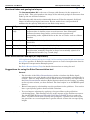
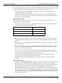
INTREPID User Manual
Library | Help | Top
Other depth estimation methods (C04)
1
| Back |
Top
Other depth estimation methods (C04)
INTREPID has two further depth estimation methods– the Euler and Phillips
methods. This chapter contains some suggestions for using them.
Using the Euler Deconvolution tool
Euler Deconvolution uses gradients to locate magnetic edges and bodies and estimate
their depths. Recent developments in depth estimation theory have spurred
development of the Extended Euler method. This is available in INTREPID v3.7,
along with the traditional, or Standard Euler method.
The INTREPID Euler Deconvolution tool processes grid datasets. See Euler
Deconvolution (T44) for detailed instructions on using the tool.
Standard Euler Deconvolution uses the analytic signal as the gradient and the
Structural Index (SI) that you specify determines the geometry of the geological
structures you are seeking. Since different geological structures have different
magnetic responses, you can configure the Euler Deconvolution tool for the structure
you require. For the nominated structure it will then produce a set of estimated
depths.
Reid et al (1990) provide a good approach to configuring the Standard Euler method
and interpreting Euler solutions.
Extended Euler Deconvolution makes use of the Hilbert transform to formulate 2 or 3
equations, which are solved for position, errors and Structural Index, assuming a
constant background. It is thus superior to the Standard method, primarily because it
does not require the Structural Index to be assumed by the user.
Theoretical explanation of the Euler method
The Euler method’s homogeneity equation relates the magnetic field and its gradient
components to the location of the source. The degree of homogeneity is expressed as a
structural index (SI). The SI is a measure of the fall-off rate of the field with distance
from the source and provides a way to discriminate between different source shapes.
Most geological boundaries or structures can be represented by assemblages of
magnetic dipoles.
Effectiveness of Euler Deconvolution
Euler Deconvolution is a well-known and well-established depth estimation method.
Our testing of the method has shown that you may need to experiment before
obtaining meaningful results.
Euler Deconvolution results may provide useful additional information when used in
conjunction with other methods.
We recommend that you read the references Reid et al (1990) and Farrelly (1997)
before using the method. Contact our reception or [email protected] if
you need assistance with obtaining copies.
Advantages of the Euler Deconvolution tool
Euler Deconvolution finds the edges of bodies, so it can locate a variety of shapes,
including irregular bodies. The tool is designed for quick and easy access to obtaining
depth estimates.
Library | Help | Top
© 2012 Intrepid Geophysics
| Back |
INTREPID User Manual
Library | Help | Top
Other depth estimation methods (C04)
2
| Back |
Structural index and geological shapes
The Structural Index (SI) is the rate of change with distance for the magnetic or
gravity field. This corresponds to the shape of the inferred geological structures that
make up the set of Euler solutions.
The following table shows the relationship between SI for the magnetic field and
shapes of inferred geological structures. Recent studies have also provided SI
numbers for the gravity field (refer to the Euler help notes.)
Value
SI Type
Shape of inferred geological structure
.5
Step or plate
edge
Step-like structures show a uniform increase or decrease in magnetic
response that is similar across several traverse lines. Examples:
Contacts between large bodies, such as between granite and
surrounding rocks; uplifted blocks at the site of a fault, such as a HorstGraben.
1
Line of dipoles
Fault/Dyke– Relatively thin sheet-like bodies that are near-vertical
(wall-like)
2
Point pole
Vertical pipe– Near-vertical cylinder shaped structures (e.g., kimberlite)
3
Point dipole
Point source (nominally spherical)– Sources that are not continuous in
any direction, normally irregular in shape but nominally spherical in
mathematical models. (e.g., basalt plug)
Euler Deconvolution example (oil exploration)
"Oil exploration interpretation case study" in Presenting regional depth and structure
data (C06) specifies an Euler Deconvolution process to create interpretation data for
the Magnetic Interpretation Example poster.
See Euler Deconvolution (T44) for detailed instructions on using the tool.
Suggestions for using the Euler Deconvolution tool
General
Library | Help | Top
•
The left side of the Euler Deconvolution window calculates the Euler depth
solutions from your grid. At the end of this stage an intermediate solutions file is
created. This is a large ASCII text file which is then accessed by the right side of
the Euler Deconvolution window (Euler Statistics Analysis) for sorting, according
to the rejection criteria you have defined. The final output is an INTREPID point
dataset.
•
Euler’s homogeneity relationship uses the gradients in the grid data. You need to
have a good quality grid to obtain reliable solutions.
•
You can improve solutions by applying a low pass filter to the grid before
calculating them. This filtering may be at the expense of the shallowest sources.
Use the INTREPID Spectral Domain Grid Filters (GridFFT) tool to apply the
filter. To remove noise that is mostly non-geological, a general rule is to set the
low pass filter to a wavelength that is greater than 2–3 times the average flying
height.
© 2012 Intrepid Geophysics
| Back |
INTREPID User Manual
Library | Help | Top
Other depth estimation methods (C04)
3
| Back |
(Example: If your survey height is 120 m, the cutoff wavelength for the low pass filter
is, say, 2.5 times 120 m, or 300 m. This is equivalent to a frequency of 1/300 cycles/m,
or 3.333 cycles/km. Use this frequency as the cutoff for the low pass filter.)
•
The grid cell size, structural index and Euler window size have the greatest
influence on resolution of depths.
•
You will sometimes create several sets of Euler solutions, each with different
parameters. For best results, examine each of these sets of solutions individually,
comparing it with the others.
Structural Index (SI)
See Structural index and geological shapes for a table of structural indices and
corresponding geological shapes.
•
A quick scan of the grid image can help determine the range of indices that will
cover most of the geological boundaries.
Features of interest
Suggested SI range
Linear trends
0.5–1.0
Well defined irregular boundaries
1.5–3.0
Isolated small responses
3
•
We recommend SI settings in the range 0 to 1 for older terrains.
•
We recommend SI settings in the range 0 to 3 for younger terrains where there
are shallow recent volcanics. Recent volcanics usually appear as many shallow
points.
•
Some types of compact magnetic mineral deposit (e.g., nickel, VMS) may respond
best to an SI of 3.
•
Other non-integer values may be specified eg 0.5, depending on the type of source.
The SI is a power law operator that is used to define the decay response of the
source. It must be non-negative.
•
Note that using different SI values will not isolate differently shaped inferred
structures. If you repeat the process with different SI values it is more likely that
you will obtain different views of the same structures.
•
Lower SI values result in the best depth estimates even though the depth
variance may be larger than for higher SI values.
•
Tight clustering of a given SI plus a low variance indicates a reliable depth
estimate.
Euler window size
•
Library | Help | Top
The size of the Euler window that is passed over the grid to solve Euler’s equation
determines the resolution of your solutions. Choice of window size is mainly
determined by the resolution of the data and the spatial extent of the anomalies.
The larger the window size, the more CPU consumption is required. The
maximum possible depth for solutions is approximately twice the Euler window
size in grid cells. Thus you should choose a window size that suit the depth ranges
that are of interest to you. With Extended Euler, the number of equations passed
to the solver is at least twice that for Standard Euler and so the window size does
not need to be as large.
© 2012 Intrepid Geophysics
| Back |
INTREPID User Manual
Library | Help | Top
Other depth estimation methods (C04)
4
| Back |
Examples:
•
If you have a grid with 70 m cells and you use an Euler window size of 12 x 12,
then the maximum depth for solutions is 2 x 12 x 70 m, or 1680 m.)
•
A small 5 x 5 window on high resolution data (eg, 20m cell size) will give good
shallow depth estimates (approximately 40m to 200m) but will not adequately
resolve much deeper responses because they are broader than the window.
•
Conversely a window of 15 x 15 will work well on deeper solutions (to 600m for
20m cell size) but not resolve the shallower solutions unless they are isolated
within the window.
Grid cell size
•
The grid cell size limits the depth for reliable Euler solutions. Solutions at depths
less than twice the grid spacing will not be reliable. (Example: if your grid has a
cell size of 80 m, you should always reject solutions with a depth of less than 160
m.)
•
For obtaining deeper depth estimates than your grid will allow, you can use it to
create a lower resolution dataset (i.e., with larger cell size). This can be done with
the INTREPID Grid Operations tool.
Selecting and classifying Euler solutions:
Euler Deconvolution produces many possible solutions, and estimates of the errors
associated with each solution. You need to select the best solutions to be able to
clearly infer geological features. There are various ways of rejecting solutions to
achieve this.
Library | Help | Top
•
Specify a Percent Depth Error parameter. Depths which have error estimates
greater than this value will be rejected.
•
Specify a lower and upper reliability percentile (Lower and Upper Goodness
Clip). The maximum and minimum values in the range are 0 and 1, referring to 0
and 100th percentiles of reliability. You can thus reject high and low reliability
solutions. (Euler generates spurious near-surface solutions which can have high
reliabilities.)
•
Specify a lower and upper Structural Index clip (Lower and Upper Structural
Clip). This applies to Extended Euler, which solves for the Structural Index and
thus will have a range of solution estimates.
•
Specify a survey observation height. The Euler depths are offset by this amount to
convert them to depths below the ground surface. This also significantly reduces
the number of spurious near-surface solutions by accepting only admissible depth
solutions.
•
Specify minimum and maximum depths. Clusters of solutions at a particular
depth are the best indicators of geological structures. To view these more clearly
you can specify minimum and maximum depths and create separate Euler
solutions point datasets for specific depth ranges (e.g.,) < 200 m, 200–1000 m and
> 1000 m.
•
Minimum and maximum X and Y extents can be used to control the geographic
extent of the output solutions.
© 2012 Intrepid Geophysics
| Back |
INTREPID User Manual
Library | Help | Top
Other depth estimation methods (C04)
5
| Back |
Displaying and understanding the results:
After selection and classification you can display each Euler solutions point dataset in
plan view as coloured symbols using the INTREPID Flight Path Editor or the
INTREPID NT or UNIX Visualisation tools.
•
Clustering at a given depth is a good guide to the accuracy of the depths.
•
It is worthwhile trying different combinations of Structural Index and Euler
Window size.
•
For representing a full range of depths, we recommend the convention of
representing Depth using symbol colour and Reliability using symbol size.
•
If you have prepared Euler datasets with different depth ranges (see the tips on
selection and classification above), display them using the same tools. This
approach can make it easier to see the clusters.
Suggested settings for different dataset types
Large low resolution datasets:
•
For a regional or sedimentary basin dataset with a grid cell size of 400 m, we
recommend the following process:
•
Use an Euler window size of 10x10;
•
Calculate and record sets of solutions using structural indices of 0, 0.5 and 1;
•
This will produce solutions with depth in the range 800 m to 8000 m.
Tip: For obtaining solutions at greater depths than your grid will allow, you can
create a lower resolution dataset from it using the INTREPID Grid Operations
tool.
High resolution datasets:
For a high resolution dataset with a grid cell size of 15 m we recommend the following
process:
•
Use Euler window sizes of 4 x 4 and 15 x 15;
•
For each of these Euler window sizes, calculate and record solutions using
structural indices of 0, 0.5, 1 and 3. These combinations will yield a total of 8 sets
of solutions.
This will produce solutions with depth in the range 30 m to 450 m
Library | Help | Top
© 2012 Intrepid Geophysics
| Back |
INTREPID User Manual
Library | Help | Top
Other depth estimation methods (C04)
6
| Back |
Summary of the Euler Deconvolution tool parameters
Refer to the General Reference for explanations of the parameters. This section
shows their default values and contains suggestions for assigning values to them.
Parameter
Default
Variations
Euler Deconvolution (calculating all solutions)
Structural Index
2
See discussion above
Percent Depth Error
50
See discussion above
Size of Euler window
10
See discussion above
Compute a Reduction to
Pole
NO
Recommended for magnetic data
Use Real*4 precision
NO
Provides faster computation at the expense of precision
Save Derivatives and
Analytic Signal
NO
Turn on only if you wish to examine this data in a grid
dataset
Selecting and classifying solutions
Survey Observation
Height
0
See discussion above
Lower / Upper Goodness
0, 1
Set by trial and error according to the density of
solutions you require.
Lower / Upper Structural
Clip
4.5, -0.5
Set by trial and error according to the density of
solutions you require.
Number of Vertical Layers
1
Vertical layers provide an automatic ‘depth slice’ facility.
Set by trial and error according to the depth ranges of
interest.
Minimum, Maximum Depth
0, 1000 (m)
Set these if you wish to limit the depth of solutions.
Max, Min, East, North
Very high,
very low
If you crop the Euler solutions point dataset to exclude
areas not of interest, INTREPID will be able to process
the dataset more quickly
Bin Size East, North
Very high,
very low
Initially select the default to view all the solutions and
their distribution. After this you can select a smaller bin
size that will apply statistics analysis to each individual
bin, thus separating areas with few solutions from those
with many.
Clip
a1
a.
Library | Help | Top
© 2012 Intrepid Geophysics
| Back |
INTREPID User Manual
Library | Help | Top
Other depth estimation methods (C04)
7
| Back |
Using the Phillips depth method
The Phillips method estimates the depth to two-dimensional steeply dipping dykelike magnetic bodies. It attempts to match many thin dyke-like bodies to the
observed response. It calculates and compares responses from a moving window. The
best fit gives the best depth estimate.
The best results occur when the window length matches the wavelength of the
magnetic responses.
This tool, therefore, works best where there is a clear separation between shallow and
deeper magnetic responses or where there are non-magnetic rocks overlying a
magnetic basement.
Phillips (1979) provides a theoretical background and computational approach for
this method.
INTREPID provides the Phillips method in its Line Filter tool for use with line
datasets.
See "Phillips automatic depth estimation" in INTREPID spatial and time domain
filters and transformations (R13) for general information about the method as used in
INTREPID.
See"Standard Spatial Domain filters" in Line Filtering (T31) for instructions on
applying the Phillips method to line data with line data output.
For advice about the use of the Phillips method, contact our technical support service.
Phillips automatic depth example (oil exploration)
"Oil exploration interpretation case study" in Presenting regional depth and structure
data (C06) specifies a Phillips automatic depth process to create interpretation data
for the Magnetic Interpretation Example poster.
Library | Help | Top
© 2012 Intrepid Geophysics
| Back |