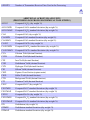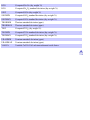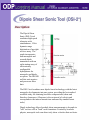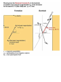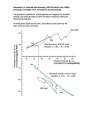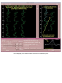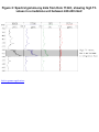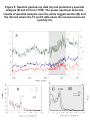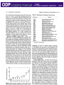
1
ODP
Logging Manual
4/2004
Any opinions, findings, and conclusions or recommendations expressed in this document
are those of the author(s) and do not necessarily reflect the views of the National Science
Foundation, Joint Oceanographic Institutions, Inc., or ODP member countries.
Home | Index of Topics
Welcome to Version 2.0 of the ODP Logging Services Electronic Manual.
There are several ways to navigate through this manual. Clicking on the Home page will
take you to a Table of Contents organized along rough chronological lines. Four main
groups of issues are presented; Pre-cruise Planning, Data Acquisition & Shipboard
Operations, Data Processing & Analysis, and Data Presentation & Post-Cruise Activities. In
addition, a separate Index of Toolstrings and Tools is provided on this page.
A navigation banner containing a link to the Home page is provided at the top of most of
the pages in this manual. Also in this banner are links to the Acronyms page, a Glossary of
Logging Terms page and an Index of Topics page. The latter is particularly useful when
you are seeking information about a specific topic but may not be sure where to find it in
the chronological menu.
Version 2 of this manual includes several significant enhancements that were not available
in the previous version. Among these is a summary chart, accessible from the Tool
Selection page, that lists all of the available logging tools and their principal scientific
applications. The Data Processing & Analysis section has been augmented, and contains
updated sections on FMS and GHMT processing. New information on integration of log
data with other data types, such as core information and seismic profiles, is now included.
The Glossary has also been significantly expanded.
We are always interested in your feedback, as our goal is to make this document as helpful
as possible to site proponents, shipboard and shore-based scientists, and JOIDES panel
members. Please feel free to contact us anytime with comments, suggestions or questions.
- ODP Logging Services
The objective of this chapter is to provide a short description of how the
loggers collect data onboard the JOIDES Resolution. It focuses on the
techniques and formats employed to produce proprietary (also called "field")
and customer (also called "field edit") tapes and how both data and the
information necessary for its processing are transmitted via satellite to ODP
Logging Services at the Lamont-Doherty Earth Observatory. For further
information about these procedures, contact the following personnel:
Data Handling and Processing
Satellite Transmission
●
Cristina Broglia
Data Services Supervisor
Tel: (845)-365-8343
Fax: (845)-365-3182
[email protected]
●
James Murray
Database Assistant
Tel: (845)-365-8639
Fax: (845)-365-3182
[email protected]
●
Trevor Williams
Log Analyst
Tel: (845)-365-8626
Fax: (845)-365-3182
[email protected]
●
Greg Myers
Technical Operations Manager
Tel: (845)-365-8772
Fax: (845)-365-3182
[email protected]
Once the Schlumberger log data have been acquired, they are routinely
loaded on DAT tapes.
Three types of DAT tapes are produced onboard:
1. Proprietary tapes (also called field tapes);
2. Customer tapes (also called field edit tapes); and
3. Backup copies of the proprietary tapes.
Proprietary tapes (field tapes) contain the original log data recorded
by the Schlumberger engineer, as well as the calibration counts
necessary for some onshore processing of the original count rates. The
original proprietary data are not depth shifted because: 1) depth shifting
can alter the sonic and geochemical waveforms recorded with the other
data; and 2) accurate depth shifting is performed on shore.
Customer tapes (field edit tapes) contain the data necessary to
perform the processing and preliminary interpretation.
Backup tapes are produced for each leg and kept on the ship for a
maximum of six months. The Logging Staff Scientist makes sure that
the backup copy/copies of the proprietary data are safely stored
onboard, in case the tapes brought onshore get lost or damaged during
transport to LDEO-BRG. Every six months, these backup tapes are
brought back or sent to LDEO-BRG to be included in the permanent
archive.
Digital log data are routinely transmitted via satellite to LDEO-BRG
after the completion of logging operations at each hole. This allows log
analysts at the LDEO-BRG Log Analysis Center to perform routine
processing of the conventional logs and transmit the data back to the
ship in ASCII format along with documentation of the processing
performed. It currently takes 2-5 days (depending on the complexity of
the processing) to perform the initial processing of a hole logged with a
full suite of logs; complete FMS, GHMT, and geochemical data
processing are performed at a later date.
Logging data are made available to the entire scientific shipboard party
immediately after the acquisition and preliminary processing are
completed. The digital data are placed on the centralized data disk,
called UserVol, and paper copies are available for the Core Lab and
Science Lounge.
The resistivity, gamma-ray, magnetic susceptibility, and density logs
are useful to sedimentologists and petrologists for reconstruction of
gaps in the lithostratigraphy (especially in cases of poor core recovery),
compiling a complete stratigraphic sequence in the area of interest, and
determining the thickness of individual units.
The FMS and BHTV images allow structural geologists to orient the
structural features observed in the cores and relate these features to the
current principal stresses associated with the present tectonic
environment.
The DSI-2, VSP, porosity, and density logs allow geophysical
properties specialists to correlate core and log results with seismic
properties and improve the interpretations of regional and local seismic
data.
The GHMT logs provide paleomagnetists with the capabilities of
producing continuous magnetostratigraphic and polarity inversion
records.
All data except FMS images are usually made available to the scientific
party within 48 hours of acquisition. They are stored as ASCII files -usually one file per logging run --and can be opened by any spreadsheet
application (such as Synergy Software's KaleidaGraph or Microsoft
Excel). Before placing the data on the Uservol server, the Logging Staff
Scientist converts the depths to meters below sea floor (mbsf) and uses
the gamma ray curves to perform a preliminary depth matching
between successive runs. More accurate depth correction is available
with the return of the processed data about a week later. For more
information, see the section on data processing.
FMS images are now also made available on the Uservol server in the
form of GIF images produced by the Logging Scientist after
preliminary processing with GeoFrame. These images, usually
produced at several different scales to maximize their utility, can be
opened in any graphic application (such as Adobe Photoshop) or
browser. Because the interpretation of FMS images is greatly enhanced
by the ability to identify and characterize structural features with
Geoframe, shipboard scientists are encouraged to familiarize
themselves with this software package in order to be able to perform
their own interpretation and correlation on the Downhole
Measurements Lab workstation – provided they don't interfere with the
critical work of the logging scientists, of course.
Schlumberger prints out detailed, expanded-scale log plots for use by
shipboard scientists. These images complement the regular page-scale
plots commonly used to define broad trends and general log units. The
fine scale resolution of the larger plots aids in detailed stratigraphic
correlation with the core. Schlumberger plots are particularly valuable
to the shipboard sedimentologists, stratigraphers, and physical
properties specialists who use them to help reconstruct the complete
stratigraphic sequence of the cored material and estimate how much,
and what type, of material is missing from the recovered section. For
example, cyclic sequences with periodic or fining upward lithologies
that are difficult to recover completely with coring can be well defined
by the addition of the detailed log information. In addition, when a
number of sites are logged in a given region, these plots are useful for
inter-site correlation and can be used to map the lateral continuity of
individual beds and units.
The Schlumberger log plots are produced by the Schlumberger engineer
after completion of logging operations. Each playback consists of three
parts: Header, Logs and Trailer.
1. Header:
The header includes information such as the hole location (latitude and
longitude), water depth, the interval drilled and logged, type of drilling
fluid, etc., which are all used later during processing.
The new Minimum Configuration MAXIS presentation also includes a
sketch of the tool string, along with the position, from the bottom of the
string, of the different sensors.
2. Logs:
This is a display vs. depth of the main curves recorded. The Logging
Staff Scientist can follow every step of the recording on the screen of
the MCM unit and thus has the option of choosing the best type of
display. Should she decide to change the type of display, the data can
be played back on the screen at the end of logging operations before
producing final blueprints.
Logs are usually displayed with depth referred to the rig floor (mbrf).
3. Trailer:
The bottom portion of the blueprints includes the after and beforesurvey calibration summary as well as the shop calibration, a list of the
sensor measure points for each tool, and a list of logging parameters.
Data
Acquisition
Logging
Operations
Stuck/Lost
Tool Policy
Shipboard
Reports
When the total depth of a hole
scheduled for logging has been
reached, a series of activities is
initiated to prepare the hole and rig
floor for the logging operation. The
borehole is conditioned by pumping a
viscous mud into the hole to flush
remnant cuttings from the borehole,
running the bit up and down to break
through any bridges or swelling clays
and finally filling the hole with a
drilling mud such as sepiolite to
stabilize the hole. Based on data
collected from the capillary suction
test (CST), the hole may be filled
with fluids containing potassium
chloride to inhibit the swelling of rehydrated clays. The next step is
determined by the type of bottom
hole assembly (BHA) used. If the
APC/XCB BHA and core barrel
assembly is deployed, logging can commence directly through the bit with the
use of a go-devil and the lockable flapper valve (LFV). If the RCB BHA and
core barrel are deployed, the drill bit must be removed using one of three
methods listed below:
1. The drill bit may be dropped at the bottom of the hole (if hole deepening
will not occur)
2. The drill bit may be dropped at the seafloor but a reentry cone or Free
Fall Funnel (FFF) is required to reenter the hole
3. A pipe trip may be used to remove the bit at the rig floor and the hole
reentered assuming a reentry cone or FFF is deployed.
Next, the base of drill pipe is placed at a depth of 50 - 80m below the sea floor
to provide confining pressure to the upper regions of the hole and to prevent the
pipe from pulling out of the hole. Once the pipe is set, the rig floor is converted
from drilling operations to logging operations.
To prepare the rig floor for logging, the top drive is pushed back and the
wireline is threaded through the derrick, winch and wireline heave compensator
(WHC). The first logging string, typically the Triple Combo, is now prepared
for rig up. The tools are assembled from the bottom up; therefore the DIT-E is
rigged up first, then the Lamont TAP tool is attached to the bottom of the DITE. These two tools are placed in the pipe and successive tools are added to the
top. After the tool string is assembled, the cablehead is attached and the tool
zero point is established by pulling the bottom of the DIT-E to the level of the
rig floor. The tool string is then lowered, the fluid seal is fastened and the tool is
run into the hole. The tool descent speed is typically 10,000 ft/hr. Once the sea
floor is reached, the tool string is held stationary for 2-3 minutes to allow the
TAP tool to equilibrate. The tool is run down to the bottom of the hole and then
pulled up at a constant rate to complete the first pass. A second pass can be
completed if desired. As the first toolstring is being pulled back to the surface,
the Schlumberger engineer may slow the ascent speed as the tool string crosses
the mud line to measure the depth of the sea floor accurately.
The first toolstring is rigged down and the TAP tool is cleaned by the logger
and returned to the Downhole Measurements Lab for the retrieval of the data.
The next toolstring (typically the FMS/Sonic) is then prepared. The same
logging procedure is followed for running the FMS/Sonic toolstring. The third
toolstring deployed may be a specialty tool such as the GHMT, WST or other.
During the logging process, the Logging Staff Scientist is involved in many
steps including:
1. Taking detailed operations notes on the Logging Event forms and
including all listed depths and times.
2. Discussing toolstring configurations with the Schlumberger Engineer.
3. Initializing the Lamont TAP tool and operating the data acquisition
system.
4. Connecting the TAP tool to the bottom of the DIT-E.
5. Disconnecting, cleaning and downloading the data from the TAP tool.
6. Remaining with the Schlumberger engineer to monitor tool progress and
to inspect the data in real-time.
Data
Acquisition
Logging
Operations
Stuck/Lost
Tool Policy
Shipboard
Reports
Stuck and lost tools are a normal occupational hazard of logging. In
spite of our best efforts to avoid tool loss, Schlumberger strings have
been lost on Legs 101, 113, 117, 122, and 175. These strings are
expensive and therefore are insured against loss in a hole; however, the
shipboard loggers obviously try their best to avoid sticking a tool, to
recover a stuck tool, and to fish for a lost tool.
If a tool is lost downhole, a reasonable effort must be made to recover
it in order to satisfy obligations to Schlumberger and the insurance
provider. The recovery effort should follow accepted practices and
include multiple recovery attempts if technically feasible. The
shorebased ODP Logging Services representative must be notified of
the stuck or lost tool situation by the Logging Staff Scientist or the
drilling superintendent.
If all reasonable efforts have been made to recover a stuck or lost tool
without success, then the decision to abandon the tool must be made
collectively by the Logging Staff Scientist, Operations Superintendent,
Rig Superintendent and the Schlumberger engineer. A report must be
filed by the Operations Superintendent and delivered to the Logging
Staff Scientist. In the event of loss involving a radioactive source, the
tool and hole must be abandoned with cement to safely entomb the
sources.
There are four main types of tool "sticking" situations:
1. The tool is either stuck in a bridge or stuck by cavings (possibly
beneath a bridge).
2. The tool is not stuck but cannot be pulled up past a bridge.
3. The tool is stuck in the base of pipe.
4. The tool is not stuck but cannot get into pipe.
There are several available strategies for dealing with stuck tools:
1. Pulling harder on the cable
Pulling harder on the cable is recommended as the first course of
action when a tool appears to be stuck. Pulling may not exceed the
combined cable weight plus weak point strength, or 50% of cable
strength, whichever is less. With this method, situations #2 and #4
have a higher chance of recovery than #1 and #3.
2. Adding pipe (if using the CSES)
If the CSES is in the tool string, stands of pipe may be added to break
through a bridge or cuttings (situations #1 and #2). Cable tension
should be maintained when lowering pipe to prevent: (A) cutting
through or kinking a slack cable with the pipe; or (B) sudden dropping
of the tool when the tool is freed (a l0'-30' free fall of the tool may be
enough to snap the weak point). Once the tool is free, you can pull it
well into pipe, raise pipe, and go back down to resume logging.
3. Cutting and stripping
Cutting and stripping involves clamping the cable at the drill floor,
cutting it, then either adding or removing a stand of pipe. For every
30m of pipe added or removed, the cable must be threaded in or out of
the pipe and re-clamped. For sticking types #1 or #2, one would add
pipe to break through the bridge. For sticking types #3 and #4, one
would remove pipe, eventually pulling the tool on deck with the
bottom hole assembly. One disadvantage of cutting and stripping is
that all of the cut cable will be discarded (perhaps 1000-3000m) and
this may not leave enough cable on the spool for subsequent logging.
The Logging Staff Scientist is responsible for making this
determination. Cutting and stripping is also not the most favorable
alternative because it is time consuming. Cutting and stripping is not
needed for situations #1 and #2 if the CSES is in the string, but a
modified type of cutting and stripping may be possible with situations
#3 and #4 with the CSES.
4. Using the Kinley crimper/cutter
The Kinley crimper and cutter system greatly increases the safety of
downhole tool recovery operations. The crimper/cutter procedure is
extremely sequence sensitive. The crimper slides down the wireline
and stops about 10m above the base of the bottom hole assembly
(BHA), then a hammer is sent down to fire the crimper which crimps
the logging cable against the BHA. A successful crimp must be
observed by the Schlumberger engineer by checking for an electrical
short inside the cable. If successful, the cutter is dropped and the cut
logging cable is reeled in. The tool is held inside the BHA and
recovered by pulling pipe to the rig floor. Crimping and cutting works
well for situation #4 but is no guarantee of success. During Leg 175,
the Kinley crimper was used to secure the tool in the pipe but it failed
to adequately crimp the cable. As the tool and drill pipe were being
pulled to the surface, the toolstring dislodged itself and fell to the
seafloor where it could not be retrieved.
5. Additional strategies
In 1988, Glen Foss (Operations Superintendent at ODP/TAMU), put
together a detailed memo on wireline stripping operations. This is
highly recommended reading. The part relevant to recovery of stuck
tools is given here.
In addition, ODP Logging Services has compiled a list of very
dangerous situations to avoid when logging, along with strategies to
avoid and cope with them.
To some degree, each stuck/lost tool situation is unique, and it is
impossible for any guidelines we give to always be appropriate. Thus,
the recommendations given in the following table should be considered
as suggestions only, not requirements:
CSES
SOLUTIONS
PROBLEM
#1. Stuck in
bridge and
cuttings
cut &
add pipe
strip
YES
--
crimp
& cut
--
pull COMMENTS
cable to
failure
--
--
#2. Cannot
pull past bridge
YES
--
--
--
--
#3. Stuck in
base of pipe
--
YESa
YESb,f
YESe
d
#4. Cannot get
into pipe
--
YESa
YESb
--
c
NO CSES
SOLUTIONS
PROBLEM
cut &
add pipe
strip
crimp
& cut
pull COMMENTS
cable to
failure
#1. Stuck in
bridge and
cuttings
--
YES
NO
--
--
#2. Cannot
pull past bridge
--
YES
YES
--
--
#3. Stuck in
base of pipe
--
YES
YESf
YESe
d
#4. Cannot get
into pipe
--
YES
YES
--
c
a - if a feasible technique can be worked out
b - after pulling the CSES on deck, and detaching it from the drill
string
c - first figure out what is hanging up, circulate while trying
(especially with lockable flapper), rotate the drillstring half a turn,
and keep trying to pull out (a centralizer or bow spring can
sometimes be snapped deliberately by repeated trials)
d - first try circulating to free the tool, with a slightly slack cable
e - a last resort if cutting and stripping is rejected; hopefully the tool
will break free before failure or, if not, be so well stuck that it will
be pulled up with the BHA
f - if the tool is too far into the pipe, the crimper will not be able to
seat
Data
Acquisition
Logging
Operations
Stuck/Lost
Tool Policy
Shipboard
Reports
The scientific results of the cruise are initially presented in the Initial Reports
(IR) volume, which is organized by site. The Logging Staff Scientist is
responsible for presenting the results of any downhole measurements made
during the leg. Any site for which logging operations are conducted requires a
chapter on downhole measurements. In this section the Logging Scientist will:
1. Present the operational details for the site. If more than one toolstring is
run, then the operations will be summarized in a table organized by
toolstring with the following information: start and stop time, logging
speed, pipe depth, mudline measured depth, interval logged for each
pass, and the tools on the string. The text will also contain general
information about the site, such as total penetration, core recovery,
muds that were circulated etc. Finally, the conditions of the hole during
logging will be discussed, as well as any obstacles or difficulties
encountered which affect data quality.
2. Present the results of the logging. This section is usually similar to the
data results of a paper in which log data are presented (in plot form) and
the pertinent features described. The presentation of results will be
tailored to the science of the leg and integrated as much as possible
with the results from other groups (physical properties, sedimentology,
biostratigraphy, magnetics, geochemistry, etc.). Frequently a summary
figure containing all of the log curves, caliper curve, stratigraphy,
sedimentology, etc., is presented. This is then followed by a breakdown
of each of the records describing them in the context of the other data,
including plots where necessary.
3. Discuss the detailed comparisons with other data, core-log
comparisons, and definitions of stratigraphic intervals. Finally, the
results of any analysis or scientific highlights of the logs will be
presented. This section may be included in each of the tool results
sections if it is not significant enough to merit an independent section.
Occasionally, the Logging Staff Scientist will collaborate with other shipboard
scientists in producing the seismic stratigraphy chapter of the Initial Reports
volume. Seismic sequence analysis is usually outlined in this chapter to
describe the structural boundaries between layers of different ages and to
provide scientific context for the proper interpretation of drilling and logging
results. The seismic profiles included in this chapter are usually collected
during pre-cruise site surveys; occasionally, seismic profiles from industry
sources are also available. The quality and density of the seismic data are
usually a function of the scientific objectives of the drilling leg. For legs on
which seismic stratigraphic sequence analysis is most important, multichannel
seismic (MCS) data are frequently available; for the others, single-channel
seismic (SCS) data are usually the norm. The specifications for the seismic
data are usually given in this chapter, including acquisition and processing.
On certain legs -- such as those on which vertical seismic profiling is
performed -- the Logging Staff Scientist will be more involved in the
collection and interpretation of seismic profiles, and thus will have a more
active role in the production of the stratigraphy chapter of the IR volume.
Geological information derived from the stratigraphic sequences is used to
define in detail the geological or tectonic setting of the leg, to design the leg
operation, and to tie seismic boundaries with core and log depths, both during
the leg and post-cruise. Proper use of the results of seismic sequence analyses
can help in the integration of core, log and seismic data and can enhance the
spatial interpretation of high-resolution profiles of structural, physical, and
chemical properties from the core and log data.
The purpose of the explanatory notes chapter of the IR volume is to provide
the reader with the technical and operational background for the wireline
logging operations conducted during the leg. Although there are an infinite
number of ways to present this material, a typical downhole logging section of
the Explanatory Notes would contain the following sections:
Introduction
This section should introduce the reader to what wireline logging is and
how it is conducted (e.g. the in situ measurement of physical, chemical,
and structural properties). It is tailored to the science relevant to the leg
under discussion and may include general principles of how these
measurements can contribute to the scientific goals of the leg. Other
points frequently included are:
❍
❍
❍
The particular advantages of wireline measurements and how
they complement the other types of analysis that will be made.
Past examples of applications and pertinent references.
Information about who provides the logging services (e.g. ODP
Logging Services & Schlumberger) and the role that each plays.
Operations
This section will provide operational details for the reader. Some
typical topics are as follows:
❍
❍
❍
❍
❍
❍
Hole is flushed with fluid.
Wiper trip is conducted.
Pipe pulled to logging depth (e.g., 90m).
Tools assembled and lowered on 7 conductor cable.
WHC employed.
Details on data acquisition system and satellite transfer methods.
Because the operations section is site specific, it is possible to cover the
general operational techniques in the introduction, specific operational
details in the site chapter, and omit this as a separate section.
Logging Tools
This section will introduce the tools and how they were combined
during the leg. Usually, figures and tables are employed to present the
information more coherently. Typically, a figure of the toolstrings
employed on the leg and a table of the tools and their depth of
investigation, sample interval, and vertical resolution are presented in
this section. In the text, the names of the tools, their acronyms, and the
measurements they make are introduced, and the theory behind the
measurements may be summarized. This will essentially amount to a
paragraph about each tool. If new tools were used or conventional tools
employed in an unconventional way, then a more detailed explanation
of the tool and the way it makes its measurements will be provided.
Data Quality
Any environmental (borehole conditions, excessive heave etc.) or
technical problems encountered on the leg will be discussed here in the
context of how they affect data quality.
Data Processing
This section is somewhat optional, but it is usually included, especially
if the logging operation employed new tools, new techniques, or data
were applied in new ways. The basics of depth shifting and correlation
between the passes are briefly presented. Then details of how particular
estimates are derived from the data will be given. For example, these
may include the onboard generation of a magnetostratigraphy (using the
GHMT) or clay typing (using natural gamma ray and photoelectric
effect).
The above sections are meant to provide guidelines for the type of information
to be conveyed in the Explanatory Notes. As the specific operations and
science of each leg is different, it may be beneficial to refer to previous
examples of explanatory notes from legs with similar scientific objectives and/
or tool deployments (e.g. 162,167,172, 175 for paleoceanography, or 118, 140,
148 or 176 for hard rock environments).
The preliminary report is meant to supply operational details and highlights of
the data which is recovered. Operational details that are usually presented
include: BHA depth, tools used and depths logged during each pass, number of
passes, problems encountered, highlights of the recovered data and its potential
utility (e.g., potential for core-log integration, cyclicity related to climate, good
magnetics that allow reversal stratigraphy etc. ).
Data
Acquisition
Logging
Operations
Stuck/Lost
Tool Policy
Shipboard
Reports
●
●
●
●
Acronyms for Schlumberger Tools
Acronyms for Third Party Tools
Acronyms and Units used for Schlumberger Logs
Additional Acronyms and Units
ACRONYMS FOR SCHLUMBERGER TOOLS
ACT
APS
ARI
ASI
BHC
CNT
CALI
CA_
C_
DIT
DLL
DSI-2
FMS
GHMT
GLT
GPIT
GR
GST
HLDS
Aluminum Clay Tool
Accelerator Porosity Sonde
Azimuthal Resistivity Imager
Array Seismic Imager
Borehole Compensated Sonic Tool
Compensated Neutron Tool
Caliper
Caliper
Caliper
Dual Induction Tool
Dual Laterolog
Dipole Sonic Imager
Formation µscanner
Geological Magnetic Tool
Geochemical Tool
General Purpose Inclinometer Tool
Natural Gamma Ray
Induced Gamma Ray Spectrometry Tool
Hostile Environment Lithodensity Sonde
HNGS
LDT
LSS
LWD-ADN
LWD-CDN
LWD-CDR
LWD-RAB
MCD
M_
NGT
N_
SDT
S_
SP
UBI
WST
WST-3
component
Hostile Environment Gamma Ray Sonde
Lithodensity Tool
Long Spacing Sonic Tool
Logging While Drilling - Azimuthal Density Neutron Tool
Logging While Drilling - Compensated Density Neutron Tool
Logging While Drilling - Compensated Dual Resistivity Tool
Logging While Drilling - Resistivity-at-the-Bit Tool
Mechanical Caliper Tool
Miscellaneous
Natural Gamma Ray Spectrometry Tool
Natural Gamma Ray Spectrometry Tool
Digital Sonic Tool
Digital Sonic Tool
Spontaneous Potential
Ultrasonic Borehole Imager
Well Seismic Tool
Well Seismic Tool-3 Component
ACRONYMS FOR THIRD PARTY TOOLS
BHTV
MCS
SST
TAP
TLT
Borehole Televiewer
Multichannel Sonic Tool
Shear Sonic Tool
High Resolution Temperature/Acceleration/Pressure Tool
Temperature Logging Tool
ACRONYMS AND UNITS USED FOR SCHLUMBERGER LOGS
AFEC
APLC
C1
APS Far Detector Count Rate (cps)
APS Near/Array Limestone Porosity Corrected (decimal fraction)
Caliper 1 (in, from FMS)
C2
CALI
CFEC
CFTC
CGR
CNEC
CNTC
DEVI
DIFF
DRH
DRHO
DT
DTCO
DTL
DTLF
DTLN
DTSM
DTST
ENPH
ENRA
FINC
FNOR
FX
FY
FZ
GR
HALC
HAZI
HBDZ
HBHK
HCFT
HCGR
HCNT
HD
HDEB
Caliper 2 (in, from FMS)
Caliper (in, from HLDT)
Corrected Far Epithermal Counts (cps)
Corrected Far Thermal Counts (cps)
Computed (Th+K) Gamma Ray (API units)
Corrected Near Epithermal Counts (cps)
Corrected Near Thermal Counts (cps)
Hole Deviation (degrees)
Difference Between MEAN and MEDIAN in Transit Time Proc. (µsec/ft)
HLDS Bulk Density Correction (g/cm3)
Bulk Density Correction (g/cm3)
Short Spacing Transit Time (10'-8' spacing; µsec/ft)
Compressional Wave Transit Time (µsec/ft)
Long Spacing Transit Time (12'-10' spacing; µsec/ft)
Long Spacing Transit Time (12'-10' spacing; µsec/ft)
Short Spacing Transit Time (10'-8' spacing; µsec/ft
Shear Wave Transit Time (µsec/ft)
Stoneley Wave Transit Time (µsec/ft)
Epithermal Neutron Porosity (%)
Epithermal Neutron Ratio
Magnetic Field Inclination (degrees)
Magnetic Field Total Moment (oersted)
Magnetic Field on X Axis (oersted)
Magnetic Field on Y Axis (oersted)
Magnetic Field on Z Axis (oersted)
Natural Gamma Ray (API units)
High Res. Near/Array Limestone Porosity Corrected (decimal fraction)
Hole Azimuth (degrees)
High Res. Bulk Density Correction (g/cm3)
HNGS Borehole Potassium (dec. fraction)
High Resolution Corrected Far Thermal Counts
HNGS Computed Gamma Ray (GAPI)
High Resolution Corrected Near Thermal Counts
Hole Diameter (in)
High Res. Enhanced Bulk Density (g/cm3)
HDRH
HFEC
HFK
HFLC
HLCA
HLEF
HNEC
HNPO
HNRH
HPEF
HRHO
HROM
HSGR
HSIG
HSTO
HTHO
HTNP
HURA
IDPH
IIR
ILD
ILM
IMPH
LCAL
LDOC
LIR
LLD
LLS
LTT1
LTT2
LTT3
LTT4
MAGB
MAGC
MAGS
High Resolution Density Correction (g/cm3)
High Res. Far Detector Count Rate (cps)
HNGS Formation Potassium (dec. fraction)
High Res. Near/FarLimestone Porosity Corrected (decimal fraction)
High Res. Caliper (in)
High Res. Long-spaced Photoelectric Effect (barns/e-)
High Res. Near Detector Count Rate (cps)
High Resolution Enhanced Thermal Nutron Porosity (%)
High Resolution Bulk Density (g/cm3)
High Resolution Photoelectric Effect (barns/e-)
High Resolution Bulk Density (g/cm3)
High Res. Corrected Bulk Density (g/cm3)
HNGS Standard (total) Gamma Ray (GAPI)
High Res. Formation Capture Cross Section (cu)
High Res. Computed Standoff
HNGS Thorium (ppm)
High Resolution Thermal Neutron Porosity (%)
HNGS Uranium (ppm)
Phasor Deep Induction (ohm-m)
Iron Indicator Ratio [CFE/(CCA+CSI)]
Deep Resistivity (ohm-m)
Medium Resistivity (ohm-m)
Phasor Medium Induction (ohm-m)
HLDS Caliper (in)
HLDS Density quality Indicator
Lithology Indicator Ratio [CSI/(CCA+CSI)]
Laterolog Deep (ohm-m)
Laterolog Shallow (ohm-m)
Transit Time (10'; µsec)
Transit Time (8'; µsec)
Transit Time (12'; µsec)
Transit Time (10'; µsec)
Earth's Magnetic Field (nTes)
Earth Conductivity (ppm)
Magnetic Susceptibility (ppm)
MEDIAN
MEAN
NMST
NMSV
NPHI
NRHB
P1AZ
PEF
PEFL
PIR
POTA
RB
RHL
RHOB
RHOM
RMGS
SFLU
SGR
SIGF
SP
STOF
SURT
SXRT
THOR
TNRA
TT1
TT2
TT3
TT4
URAN
VP1
VP2
VPCO
VPSH
VPST
Median Transit Time Recomputed (µsec/ft)
Mean Transit Time Recomputed (µsec/ft)
Magnetometer Temperature (°C)
Magnetometer Signal Level (V)
Neutron Porosity (%)
LDS Bulk Density (g/cm3)
Pad 1 Azimuth (degrees)
Photoelectric Effect (barns/e-)
LDS Long-spaced Photoelectric Effect (barns/e-)
Porosity Indicator Ratio [CHY/(CCA+CSI)]
Potassium (wet wt. %)
Pad 1 Relative Bearing (degrees)
LDS Long-spaced Bulk Density (g/cm3)
Bulk Density (g/cm3)
LDS Corrected Bulk Density (g/cm3)
Low Resolution Susceptibility (ppm)
Spherically Focused Log (ohm-m)
Spectroscopy Gamma Ray (API units)
APS Formation Capture Cross Section (cu)
Spontaneous Potential (mv)
APS Computed Standoff
Receiver Coil Temperature (°C)
NMRS differential Temperature (°C)
Thorium (ppm)
Thermal Neutron Ratio
Transit Time (10' spacing; µsec)
Transit Time (8' spacing; µsec)
Transit Time (12' spacing; µsec)
Transit Time (10' spacing; µsec)
Uranium (ppm)
Compressional Wave Velocity (Short Spacing or Mean Transit Time; km/s)
Compressional Wave Velocity (Long Spacing or Median Transit Time; km/s)
Compressional Wave Velocity (from DTCO; km/s)
Shear Wave Velocity (from DTSM; km/s)
Stonely Wave Velocity (from DTSM; km/s)
#POINTS
AL2O3
Number of Transmitter-Receiver Pairs Used in the Processing
ADDITIONAL ACRONYMS AND UNITS
(PROCESSED LOGS FROM GEOCHEMICAL TOOL STRING)
Computed Al2O3 (dry weight %)
AL2O3MIN
Computed Al2O3 standard deviation (dry weight %)
AL2O3MAX
Computed Al2O3 standard deviation (dry weight %)
CAO
CAOMIN
CAOMAX
CA2O3
Computed CaO (dry weight %)
Computed CaO standard deviation (dry weight %)
Computed CaO standard deviation (dry weight %)
Computed CaCO3 (dry weight %)
CA2O3MIN
Computed CaCO3 standard deviation (dry weight %)
CA2O3MAX
Computed CaCO3 standard deviation (dry weight %)
CCA
CCHL
CFE
CGD
CHY
CSI
CSIG
CSUL
CTB
CTI
FEO*
FEO*MIN
FEO*MAX
FE2O3
Calcium Yield (decimal fraction)
Chlorine Yield (decimal fraction)
Iron Yield (decimal fraction)
Gadolinium Yield (decimal fraction)
Hydrogen Yield (decimal fraction)
Silicon Yield (decimal fraction)
Capture Cross Section (capture units)
Sulfur Yield (decimal fraction)
Background Yield (decimal fraction)
Titanium Yield (decimal fraction)
Computed FeO* (dry weight %)
Computed FeO* standard deviation (dry weight %)
Computed FeO* standard deviation (dry weight %)
Computed Fe2O3 (dry weight %)
FE2O3MIN
Computed Fe2O3 standard deviation (dry weight %)
FE2O3MAX
Computed Fe2O3 standard deviation (dry weight %)
GD
GDMIN
GDMAX
Gadolinium (dry weight %)
Gadolinium standard deviation (dry weight %)
Gadolinium standard deviation (dry weight %)
K2O
Computed Fe2O3 (dry weight %)
K2O
Computed Fe2O3 standard deviation (dry weight %)
SIO2
Computed SiO2 (dry weight %)
SIO2MIN
Computed SiO2 standard deviation (dry weight %)
SIO2MAX
Computed SiO2 standard deviation (dry weight %)
THORMIN
THORMAX
TIO2
Thorium standard deviation (ppm)
Thorium standard deviation (ppm)
Computed TiO2 (dry weight %)
TIO2MIN
Computed TiO2 standard deviation (dry weight %)
TIO2MAX
Computed TiO2 standard deviation (dry weight %)
URANMIN
URANMAX
VARCA
Uranium standard deviation (ppm)
Uranium standard deviation (ppm)
Variable CaCO3/CaO calcium carbonate/oxide factor
ABCDEFGHIJKLM
NOPQRSTUVWXYZ
A
Acoustic log: A generic term for well logs which display any of several aspects of acousticwave propagation. In some acoustic logs (sonic log, continuous velocity log), the travel time
of the compressional wave between two points is measured. In others (amplitude log), the
amplitude of part of the wave train is measured. Other acoustic logs (character log, three-D
log, VDL-log, microseismogram log, signature log) display part of the wave train in wiggle
or variable density form. Still others (cement-bond log, fracture log) are characterized by the
objective of measurements rather than their form. The borehole televiewer is also an acoustic
log.
Acoustic wave: 1) Sonic wave. An elastic wave train, sometimes restricted to propagation
through a fluid. 2) The wave train generated and detected by a sonic-logging sonde. The
wave train is a composite of various modes of energy transfer. The first arrival usually
results from compressional (P- or longitudinal) waves traveling in the formation; the inverse
of its velocity is measured by the sonic log. A second arrival is sometimes identified as shear
(S-) wave travel in the formation; it represents a pseudo-Rayleigh wave which travels at
approximately the velocity of S-waves. Compressional waves traveling through the mud
usually have relatively high frequency content; they are sometimes called fluid waves. One
or more modes of high-amplitude, low frequency tube waves (sometimes called Stonely
waves) are usually very distinct arrivals. 3) More generally, an elastic wave or seismic wave.
Advanced Piston Corer (APC): A coring device used to obtain near-complete core
recovery when sediments are very soft (usually the uppermost 100-200 m of section).
API Units: (1) A unit of counting rate for the gamma-ray log. The difference between the
high and low radioactivity sections in the API calibration pit is defined as 200 API units. (2)
A unit of counting rate for the neutron log. The reading in the Indiana limestone portion of
the API neutron log calibration pit which has 19% porosity and is saturated with fresh water
is defined as 1000 API units.
Auxiliary Measuring Sonde (AMS): A Schlumberger tool that can be added to any digital
string, yielding measurements of hole temperature and head tension.
B
Borehole effect: A distortion of a well log because of the size and influence of the borehole
or (sometimes) the invaded zone.
Bottom Hole Assembly (BHA): The lowest 70-100 m portion of the drillstring, made of
thicker steel with a smaller inner diameter than normal pipe. Different BHAs are used for
APC/XCB coring and RCB coring.
Bridge: A hole constriction too small for the logging tool to pass through, caused sometimes
by clay swelling and sometimes by caving of fractured formations.
Bridle: (1) The insulation covered lower portion of the cable to which a logging tool is
connected. (2) To connect in parallel a group of amplifiers to a common input. (3) An
arrangement for towing a seismic streamer.
C
Caliper: A tool used for measuring the diameter of a borehole. The measurements are
displayed as a caliper log. Open hole caliper logging tools often have four or more arms.
Casing: Tubes or pipes used in boreholes to keep them from caving in. Usually made in
pieces of ten feet lengths that screw together.
Cement-bond log: A well log of the amplitude of the acoustic wave which indicates the
degree of bonding of cement to the casing and formations. If the casing is poorly cemented,
energy which travels through the casing at the fast speed of acoustic waves in steel is strong
and little energy travels in the formation; if the casing is well cemented, the casing signal
nearly disappears and the formation signal is strong. The log may consist of: (1) an
amplitude log (CBL) which represents the amplitude of a portion of the longitudinal acoustic
wave train; or (2) a display of the acoustic wave train such as the character log, 3-D,
microseismogram, VDL, or acoustic signature log.
Check Shot Survey: Seismic sources shot into a borehole where a seismic recording tool
records travel times for checking results of integrating a continuous velocity or sonic log.
Compensated log: A well log made with a sonde designed to correct unwanted effects. The
compensated density log uses the signal from a secondary detector to correct for the effect of
mud cake and small irregularities in the borehole wall. The compensated sonic log uses a
special arrangement of the transducers to correct for irregularities in the borehole size and
sonde tilt.
Continuous velocity log: A sonic log; a log of formation velocity against depth. The
quantity recorded and graphed is usually the reciprocal of the velocity, the travel time over a
short interval, often expressed in µsec/ft.
Customer tape: Tape containing the data used in the processing of standard logs.
Cycle skipping: In acoustic or sonic logging, the first arrival is sometimes strong enough to
trigger the receiver closest to the transmitter but not the farthest receiver, which may then be
triggered by a later cycle resulting in an erroneously high transit time. This situation is called
cycle skipping. Its onset is characterized by an abrupt deflection corresponding to an added
cycle of travel between receivers. Short cycle skipping, where the near receiver is triggered
by a cycle too late, also can occur, resulting in an abnormally short travel-time.
D
Density log: A well log which records the formation density. The logging tool consists of a
gamma ray source (e.g., Cs137) and a detector so shielded that it records backscattered
gamma rays from the formation. This secondary radiation depends on the density of
electrons, which is roughly proportional to the bulk density. The source and detector are on a
skid which is pressed against the borehole wall. Compensated density logging tools include a
secondary detector which responds more to the mud cake and small borehole irregularities;
the response of the second detector is used to correct the readings of the main detector.
Depth of investigation: The radius about a logging sonde within which material contributes
significantly to the readings from the sonde.
Dipmeter: A well log from which the magnitude and azimuth of formation dip can be
determined. The resistivity dipmeter includes: (a) three or more microresistivity readings
made using sensors distributed in azimuth about the logging sonde; (b) a reading of the
azimuth of one of these; (c) a reading of the hole deviation or drift angle; (d) its bearing; and
(e) one or two caliper measurements. The microresistivity curves are correlated to determine
the differences in depth of bedding markers on different sides of the borehole and dip
calculations are based on such correlations.
E
Eccentralize: To push a logging tool from the center of the borehole to the borehole wall.
This is often accomplished by a mechanical arm in the logging tool, actuated at the
beginning of the upward logging run. Nuclear logging tools, for example, need to be
eccentralized to make correct measurements.
Environmental Corrections: Log data are adversely influenced by downhole conditions
such as pressure, salinity, drilling mud, filter cake, etc. The effects of these environmental
conditions on the data may be eliminated post-cruise though environmental correction
software.
Extended Core Barrel (XCB): A thin bit which extends beyond the normal bit, for high
core recovery when sediments are too firm for use of the advanced piston corer.
F
Flowmeter: A device that measures the flow of fluid in the borehole or casing at specified
depth intervals. Sometimes the flowmeter is lowered through the flow stream in a borehole
and sometimes it is set in one spot with a packer.
G
Gamma-ray log: A well log which records the natural radioactivity. 1) In sediments the log
mainly reflects shale content because minerals containing radioactive isotopes (the most
common of which is potassium) tend to concentrate in clays and shales. Volcanic ash,
granite wash, and some salt deposits also give significant gamma-ray readings. The log often
functions as a substitute for the SP for correlation purposes in cased holes, in conductive
muds in open holes, and for thick carbonate intervals.
H
Hydraulic Bit Release (HBR): Equipment inserted next to the bit while "making
up" (putting together) an RCB bottom hole assembly, to permit dropping the bit for logging.
A "go-devil" is sent down the pipe to release bit latches and seal the bit opening, then the bit
is pumped off by applying hydraulic pressure. The HBR usually does not release
immediately but needs a fair amount of work to get off; sometimes it refuses to release, and
we either cannot log or have to wash a new hole for logging.
I
Induction log: An electrical conductivity/resistivity well log based on electromagneticinduction principles. A high-frequency alternating current of constant intensity induces
current flow in the formation. This Foucault current flowing in the formation ground loop
causes an alternating magnetic field which produces a current in a receiving coil. The
receiving-coil current is nearly proportional to the conductivity of the formation. Induction
sondes may have several transmitting and receiving coils to produce a highly focused log.
An induction log can be recorded where the borehole fluid is conductive or nonconductive,
as in oil-base muds or gas. A dual induction log measures different depths of penetration.
Interval transit-time: The travel time of a compressional sonic (seismic) wave over a unit
distance, hence proportional to the reciprocal of P-wave velocity. Measured in the sonic log,
usually in microseconds per foot.
Invaded zone: The portion about a wellbore into which drilling fluid has penetrated,
displacing some of the formation fluids. Invasion takes place in porous, permeable zones
because the pressure of the mud is kept greater than that of the formation fluids. A mud cake
builds on the formation wall, limiting further flow of mud fluid (filtrate) into the formation.
Directly behind the mud cake is a flushed zone from which almost all of the formation water
and most of the hydrocarbons have been displaced by filtrate. The invasion process alters the
distribution of resistivities and other properties and consequently the value which logs read.
The depth of invasion is the equivalent depth in an idealized model rather than the maximum
depth reached by filtrate. In oil-bearing intervals, the filtrate may push a bank of formation
water ahead of it to produce a relatively low-resistivity annulus which is especially important
with deep-investigation induction logs.
J
K
L
Logging-While-Drilling (LWD): Process by which downhole geophysical logs are acquired
during drilling operations. LWD acquires data from sensors integrated into the drill string
immediately above the drill bit. LWD records data minutes after cutting the hole, closely
approximating in situ conditions. This forefront industry technology provides high quality
logging information in environments where standard wireline systems previously acquired
either no data or poor quality data. Specifically, LWD provides excellent quality results in
deviated holes or unstable environments that may preclude wireline log runs. In addition to
the acquisition of logging data in potentially unstable boreholes where high-quality wireline
data cannot be acquired, LWD measurements also offer at least two other operational
advantages over standard coring and wireline operations: (1) in situ logs and azimuthal
borehole images are acquired over the entire drilled interval, providing data over the critical
section; and (2) data is either saved in memory or transmitted during drilling, hence data can
be obtained without dismantling the drill string and the chances of borehole wall collapse are
reduced.
M
MBSF: meters below sea floor.
MBRF: meters below rig floor.
Measurement-While-Drilling (MWD): Drilling and logging technology very similar to
LWD (Logging-While-Drilling). MWD data is telemetered to a surface acquisition system in
real-time, while LWD data is stored in downhole memory until the tool is pulled to the
surface and the data retrieved. The MWD tools are now routinely used in industry, often
together with LWD tools, to monitor drilling parameters in real time. A significant
advantage of measuring downhole weight-on-bit is that it allows for changes in the rate of
penetration to be quantified in terms of formation strength through a simple transform. When
calibrated to shear strength measurements on core, this estimate of downhole formation
strength together with LWD and core measurements of porosity, density and lithology
provides an improved determination of the pore-pressure and effective stress at depth.
N
Neutron Activation: Radioactive sources in density and porosity tools emit neutrons into
the formation as part of the routine density and porosity measurements. If a toolstring with
radioactive sources is stationary in the hole for any amount of time, residual neutrons will
remain in the borehole for a small period of time in the location adjacent to source. This
neutron activation does not usually last more than a few hours, but it is detectable with the
gamma tool and can be falsely interpreted as a high gamma count interval.
Neutron log: A porosity well log which measures mainly hydrogen density. Fast neutrons
emitted by a source in the tool are slowed to thermal speed by collisions with (mainly)
hydrogen atoms. The thermal neutrons are then captured by atomic nuclei of the surrounding
material (mainly chlorine atoms) at which time a characteristic gamma ray of capture is
given off. Porosity calculated from the neutron log is affected somewhat by the formation
matrix and by the presence of gas. Neutron logs are used in crossplots to detect gas and
determine lithology. Neutron logs are sometimes scaled in API units, sometimes in porosity
units assuming a limestone matrix. The neutron log can be recorded in cased holes.
O
P
Permeability: A measure of the ease with which a fluid can pass through the pore spaces of
a formation. Measured in millidarcy (1/1000 darcy) units. The permeability constant k is
expressed by Darcy's law as µq/(dp/dx), where µ is fluid viscosity, q is linear rate of flow,
and dp/dx is the hydraulic pressure gradient.
Pigtail: A 4-foot long piece of logging cable, modified with electrical connectors at each
end, which converts the rope socket (Schlumberger cable termination) via the torpedo to the
Gearhart Owen (G.O.) cablehead used on the specialty tools.
Processed Data: Logging data that has been processed using a specific log analysis system
(such as GeoFrame or Logos). Processing includes depth shifting, environmental corrections,
quality control and the creation of ASCII files for the online database.
Proprietary Data: The entirety of logging data collected by the Schlumberger acquisition
system aboard the JOIDES Resolution.
Proprietary Tape: A tapes containing the original log data recorded by the Schlumberger
engineer, as well as the calibration counts necessary for some onshore processing of the
original count rates.
Pull Out of Hole (POOH): A term used to describe the upward trip of either a logging tool
or the drillstring. Most commonly, it refers to the distance from the bottom of the hole to the
drill floor, but distances to specific depths below the seafloor can also be specified (e.g.,
"POOH to 70 mbsf" means raising pipe from the bottom of the hole to 70 mbsf).
Q
R
RCB: Rotary Core Barrel. Used after the APC/XCB core barrels to drill hard rocks. Logging
tools cannot pass through an RCB bit; therefore, the bit must be removed prior to logging.
Resistivity: The property of a material which resists the flow of electrical current. Also
called specific resistance. The ratio of electric-field intensity to current density. The
reciprocal of resistivity is conductivity.
Resistivity logs: Well logs which depend on electrical resistivity: normal, lateral, laterolog
and induction log. Most resistivity logs derive their readings from 10 to 100 ft3 of material
about the sonde. Microresistivity logs on the other hand derive their readings from a few
cubic inches of material near the borehole wall.
Rigup (RU): To assemble a toolstring or piece of equipment in preparation for deployment.
Rigdown (RD): To disassemble a toolstring following deployment.
ROP: Rate of penetration.
Run Into Hole: The opposite of POOH.
S
Schlumberger Workshop: A room on the JOIDES Resolution immediately beneath the
logging winch, containing Schlumberger supplies and the ozalid machine for paper copies of
logs.
Scintillation Counter: An instrument for measuring radioactive radiation, especially from
gamma rays. Gamma radiation impinging on a sensitive phosphor causes it to emit light
(scintillations) which is measured by a photo-multiplier tube.
Secondary porosity: Porosity resulting from the alteration of the formation such as by
fractures, vugs, solution channels, dolomitization, etc.
Seismic Source: The sound source used for the collection of seismic reflection data. In the
early days of seismic exploration of watered covered areas, the source was always a form of
unconfined explosion. However, an unacceptable level of environmental damage resulted
from this method and it was soon clear that there was a pressing need to generate seismic
waves that did not have sufficiently high peak pressures to cause damage to marine fauna. In
addition, explosive sources created a so-called "bubble effect" – an undesirable artifact in a
seismic record caused by oscillations of gas bubbles generating repetitions of first arrivals.
Because of the consistency of the water medium, it is possible to generate energy within the
frequency band used for seismic exploration by a more controlled release of gas pressure (air
gun) or by other means of producing a sudden volume increase within the water column
(water gun) while at the same time minimizing the bubble effect. The requirements for a
marine seismic source are:
1. Ability to generate a discrete powerful pulse or signal that can be subjected to later
compression in time.
2. A rechargeable or repeatable system which can be used in a sequence of operations at
short intervals of time (10 seconds or so).
3. A relatively simple system that will operate consistently, trouble-free, and have a
long life between overhauls.
4. A system that can be used in constant depth below the water surface and results in a
minimum drag on the vessel carrying it.
5. A system that does not injure marine life.
6. A system that minimizes the bubble effect.
Seismic guns currently available on the JOIDES Resolution:
❍
❍
❍
❍
3 /80 cu. in. SSI water guns.
2 /200 cu. in. Hamco water guns.
1 /400 cu. in. SSI water gun.
1 /1500 Bolt Airgun capable of 120 to 1000 cu. in.
Shoulder-bed effect: Effect of adjacent beds on a log reading. Also called the adjacent bed
effect. For example, high resistivity beds adjacent to a low resistivity bed may result in more
current flowing in the low-resistivity bed than if the high-resistivity bed were not present,
thus changing the apparent resistivity of the low-resistivity bed.
Sonic log: A well log of the travel time for acoustic waves over a unit distance, and hence
the reciprocal of the longitudinal wave (P-wave) velocity. Also called acoustic velocity log
and continuous velocity log. Usually measured in microseconds per foot. Especially used for
porosity determination by the Wyllie relationship. The interval transit time is integrated
down the borehole to give the total travel time. For the compensated sonic log, two
transmitters are pulsed alternately; averaging the measurements tends to cancel errors due to
sonde tilt or changes in hole size.
Spontaneous Potential (SP): Also called self potential. 1) A well log of the difference
between the potential of a movable electrode in the borehole and a fixed reference electrode
at the surface. The SP results from electrochemical SP and electrokinetic potentials which
are present at the interface between permeable beds adjacent to shale. In impermeable shales,
the SP is fairly constant at the shale base-line value. In permeable formations the deflection
depends on the contrast between the ion content of the formation water and the drilling fluid,
the clay content, the bed thickness, invasion, and bed-boundary effects, etc. In thick,
permeable, clean nonshale formations, the SP has the fairly constant sand line value, which
will change if the salinity of the formation water changes. In sands containing disseminated
clay (shale), the SP will not reach the sand line and a pseudostatic SP value will be recorded.
The SP is positive with respect to the shale base-line in sands filled with fluids fresher than
the borehole fluid. 2) The DC or slowly varying natural ground voltage observed between
nearby nonpolarizing electrodes in field surveying. In many mineralized areas this is caused
by electrochemical at the electrically conducting sulfide body.
Stand: A 30-meter segment of pipe, made up of 3 10-meter pipe joints. This is the usual
increment for adding or removing pipe.
Stoneley wave: 1) A type of seismic wave propagated along an interface. 2) A surface wave
in a borehole.
Synthetic Seismogram: An artificial seismic reflection record manufactured from velocitylog data by convolving the reflectivity function with a waveform which includes the effects
of filtering by the Earth and recording system. Used to compare with an actual seismogram
to aid in identifying events or predicting how stratigraphic variation might affect a seismic
record. Often constructed from sonic log data alone although density data may also be
incorporated. Generally assumes plane interfaces and plane waves, sometimes a point
source. Synthetic seismograms sometimes show primary events only, primaries plus selected
multiples, or primaries plus all multiples; they may be constructed by analog, digital, or
manual methods.
T
Tadpole Plot: A type of plot of dipmeter or drift results, also sometimes called an arrow
plot. The position of a dot gives the dip angle versus depth and a line segment pointing from
the dot gives the direction of dip, using the usual map convention of North being up.
Telemetry: Communication with a remote acquisition system. Logging tools usually
transmit acquired data in real-time via wireline telemetry.
Temperature log: A well log of temperature, often made with a resistance thermometer
(thermistor). Used for locating cement behind the casing (because the setting of cement is
exothermic and hence raises temperature), intervals which are producing gas (because the
expansion of gas as it enters the borehole lowers the temperature), and fluid flows
(particularly behind the casing).
Total depth: Final depth achieved during drilling operations.
U
V
Vertical Seismic Profile (VSP): A VSP differs from a conventional reflection profile in that
the receiver is clamped successively at different borehole depths within the Earth. The
seismometer records both the direct, downgoing waves and upgoing waves reflected from
acoustic impedance changes below the clamping depth. Interval velocities may be calculated
from the difference in arrival time of the direct wave between receiver depths. Processing
techniques can be applied to separate the upgoing and downgoing wavefields, which can
then be analyzed for attenuation properties of rock, prediction of acoustic properties below
the bottom of the hole, and correlation with borehole lithology, wireline logs, and events on
conventional seismic reflection profiles.
W
Washout: A borehole feature where the gauge of the hole increases substantially due to
caving or erosion during the drilling processes.
Wavelet: A seismic pulse usually consisting of 1-1/2 to 2 cycles.
Wiper Trip: The action of pulling pipe from the bottom of the hole to logging depth, then
lowering pipe back to bottom, or the opposite. Wiper trips are always pipe round trips to
clean the hole for logging, usually at a much slower speed than normal pipe trips to avoid
damaging the hole.
Wireline: A cable comprising one or conductors which is lowered into a borehole and
provides for real-time communication between a tool and the surface.
X
Y
Z
ABCDEFGHIJKLM
NOPQRSTUVWXYZ
A
Accelerator Porosity Sonde (APS)
Acronyms used in logging
Acoustic wave propagation, explanation of
Array Seismic Imager (ASI)
Array Sonic (SDT)
Azimuthal Resistivity Imager (ARI)
B
Backup sonic tools
Backup tapes
Borehole Compensated Tool (BHC)
C
Cableheads
Calibration equipment
Capillary Suction Tester (CST)
CD-ROM of log data
Conical Sidewall Entry Sub (CSES)
Core Barrel Temperature Tool (CBTT)
Core/Log integration (Splicer & Sagan software packages)
Customer tapes
Cyclicity in logs
D
Data acquisition & transfer
Data distribution
Data processing (overview)
Dipole Shear Sonic Tool (DSI-2)
Downhole Measurements Lab (DHML)
Drill String Acceleration Tool (DSA)
Dual Porosity Compensated Neutron Log (CNT-G)
Dual Laterolog (DLL)
E
Estimating logging times
F
Fluid seal
FMS processing
FMS/Sonic toolstring
Formation Microscanner (FMS)
G
General Purpose Inclinometry Cartridge (GPIT)
Geochemical Tool (GLT)
Geological High Resolution Magnetic Tool (GHMT)
GHMT processing
Glossary of terms
Go-devil
GRC Ultra High T Temperature Tool
H
High-T Temperature Tool (HTT)
High temperature logging operations
Hole finder
Hostile Environment Gamma Ray Sonde (HNGS)
Hostile Environment Lithodensity Sonde (HLDS)
How to use this manual
I
IESX - Core/Log/Seismic Integration
Initial Reports -- Explanatory Notes
Initial Reports -- Logging Chapter
Initial Reports -- Seismic Stratigraphy Chapter
J
JOIDES Logger
K
Kinley crimper/cutter
L
Lockable Flapper Valve (LFV)
Log plots, Schlumberger
Log processing
Log/Seismic Integration (IESX)
Logging operations
Logging Staff Scientist
Logging times, estimation of
Logging tool response in sedimentary minerals (table)
Logging-While-Drilling -- Azimuthal Density Neutron Tool (LWD-ADN)
Logging-While-Drilling -- Compensated Density Neutron Tool (LWD-CDN)
Logging-While-Drilling -- Compensated Dual Resistivity Tool (LWD-CDR)
Logging-While-Drilling -- Isonic Tool (LWD-Isonic)
Logging-While-Drilling -- Resistivity-at-the-Bit Tool (LWD-RAB)
Long Spacing Sonic (LSS)
Lost tools
LWD, deployment of
M
Measurement-While-Drilling (MWD)
Minimum Configuration MAXIS system (MCM)
Milankovitch cycles
Multi-Sensor Spectral Gamma Ray Tool (MGT)
N
Natural Gamma Ray Tool (NGT)
O
On-line data
P
Phasor Dual Induction -- Spherically Focused Resistivity Tool (DIT-E)
Post-cruise meetings
Pre-cruise meeting
Project team
Proprietary tapes
Q
R
S
Sagan software package
Satellite data transmission
Schlumberger log plots (playbacks)
Sheaves
Shipboard reports
Sidewall Entry Sub (CSES)
Sources
Specialty tools, index of
Splicer software package
Stuck tools
T
Temperature/Acceleration/Pressure Tool (TAP)
Third party tool support
Toolstring selection
Toolstrings, index of
Torpedo
Triple Combo toolstring
U
Ultrasonic Borehole Imager (UBI)
V
W
Well Seismic Tool (WST)
Well Seismic Tool 3 Component (WST-3)
Well Seismic Tool, deployment of
Winch
Wireline, descriptions and types
Wireline Heave Compensator (WHC)
X
Y
Z
How to contact us:
Mailing Address:
E-Mail:
Fax:
Phone:
Web:
Borehole Research Group
Lamont-Doherty Earth Observatory
Rt. 9W
Palisades, NY 10964
[email protected]
(845)-365-8132
(845)-365-8674 (Director)
(845)-365-8672 (Deputy Director)
(845)-365-8772 (Manager, Technical Services)
http://www.ldeo.columbia.edu/BRG/ODP/
The main purpose of shore-based log processing is to provide scientists
with a comprehensive quality controlled downhole log data set. This
data set can then be used for comparison and integration with core and
seismic data from each ODP leg: the Sagan in-house software is used
to put cores and logs on the same depth scale; and IESX software is
used to analyze seismic sections and generate synthetic seismograms
from the logs. Shore-based log processing comprises:
❍
❍
❍
❍
❍
Depth adjustments to remove depth offsets between data from
different logging runs
Corrections specific to certain tools and logs
Documentation for the logs, with an assessment of log quality
Conversion of the data to a widely accessible format (ASCII for
the conventional logs, GIF for the FMS images and summary
diagrams)
Assembling the data for inclusion in the ODP Logging Services
on-line and tape databases.
Log analysts at ODP Logging Services carry out the processing, mostly
using Schlumberger GeoQuest’s "GeoFrame" software package.
Conventional log data (natural gamma radioactivity, resistivity,
density, porosity, sonic velocity, magnetic susceptibility logs) are
transmitted via satellite from the ship, processed, and returned to the
ship, usually within a week of logging. Processing of other log data
(FMS images, GHMT magnetic polarities, etc.) is done after the cruise,
either because the file sizes are too large to transmit via satellite, and/or
the processing time is longer.
For details on the various types of processing, click on the appropriate
link:
❍
❍
❍
Log Processing
Core/Log Integration (Splicer & Sagan)
Log/Seismic Integration (IESX)
Data Processing
Overview
Log
Processing
Core/Log Integration
(Splicer & Sagan)
Log/Seismic
Integration (IESX)
Depth adjustments
The main processing task is to remove depth discrepancies between the
different logging runs. Such discrepancies are caused by cable stretch,
incomplete heave compensation, and by tides. The natural gamma ray
log (SGR and HSGR) is generally used to match between the logging
runs, as this log is recorded on all toolstrings. One gamma log is chosen
as the reference, on the basis of the length of the logged interval and
data quality. The other gamma logs are matched to the reference using
an automatic routine; the match of each log is checked to make sure
distinctive peaks and troughs line up, and the match is adjusted, as
necessary, by the log analyst. The resulting depth shifts are then
applied to the other logs on the tool strings. The depth reference is then
shifted from the rig floor to sea floor, which is determined from the
step in the natural gamma log seen at the sediment-water interface.
Environmental corrections
Environmental corrections are designed to remove any effect from the
borehole (size, roughness, temperature, tool standoff) or the drilling
fluids that may partially mask or disrupt the log response from the
formation. Onshore, only the natural gamma (NGT) logs are generally
corrected. The logs from the HNGS, HLDS, and APS tools are
corrected in near-real time during log acquisition.
Sonic log corrections
Sonic slowness logs from the SDT, LSS, and DSI-2 sonic tools are
routinely edited to remove noise and cycle-skips that are often present
in the raw log. The travel times are converted into sonic velocities.
Quality control and documentation
The quality of the data is assessed in terms of reasonable values for the
logged formation, repeatability between different passes of the same
tool, and correspondence between logs affected by the same formation
property (e.g., the resistivity log should show similar features to the
sonic velocity log). Invalid data at the top (affected by the bottom hole
assembly) and bottom of the logs are removed. Depth adjustments,
corrections, and data quality are documented in the processing report.
Data delivery
The processed data are saved as ASCII files and transmitted via
satellite back to the ship. They are also put in the on-line database, the
Initial Reports CD-ROM, and are archived to tape in LIS/DLIS format.
Processing is required to convert the 64 electrical current traces
recorded by the FMS into a color-scale image representative of the
conductivity changes in the formation.
BorEID corrections
Several corrections are applied using the BorEID module of GeoFrame:
1. Speed Correction. The data from the z-axis accelerometer are
used to correct the vertical position of the data for variations in
the speed of the tool ("GPIT speed correction"), including "stick
and slip." In addition, "image-based speed correction" is also
applied to the data, based on reducing any offset between the
data from two rows of button electrodes on each FMS pad.
2. Equalization. The responses of the button electrodes on the
pads of the tool are equalized to correct for various tool and
borehole effects which affect individual buttons differently.
3. Button Correction. If the measurements from a button
electrode are unreasonably different from its neighbors (e.g.,
"dead buttons"), the defective trace is replaced by traces from
adjacent good buttons.
4. EMEX voltage correction. During logging, the voltage that
drives the current is continuously regulated so that current flows
even through very resistive formations. The button response is
divided by the EMEX voltage so that the response corresponds
more closely to the conductivity of the formation.
Depth adjustment
The natural gamma log (SGR) resulting from the BorEID speed
correction is matched to the SGR log from the same pass after
conventional log depth shifting. The logs are checked for a good match,
and then the resulting depth shifts are applied to FMS images and their
associated logs (pad azimuth, etc.). The resulting FMS images are then
on a comparable depth scale to the conventional logs.
Image normalization
Using the BorNor module of GeoFrame,
"static" and "dynamic" normalizations of the
image are applied. In the static normalization,
the resistivity range of the entire interval of
data is computed, and is partitioned into 256
color levels; this image is good for examining
large-scale resistivity variations. In the
dynamic normalization, the full range of color
levels is assigned to resistivity range of short
intervals (e.g., 2m); thus the color contrast is increased, enhancing the
fine details of the resistivity structure.
Data delivery
Static images are output as GIF files and added to the on-line database
and the Initial Reports CD-ROM. In the future, dynamic images will be
treated in a similar manner. The FMS data are also saved in DLIS
format and archived.
Once the GHMT logs have been depth shifted, the magnetic polarity
stratigraphy is determined as follows:
1. The Earth’s main field and the field of the metal drill pipe are
subtracted from the total magnetic field log (MAGB) to isolate
the field anomaly caused by the local formation.
2. The local field anomaly is caused by
the induced and remanent
magnetizations of the local
formation (see figure). The induced
anomaly can be calculated from the
magnetic susceptibility log
(MAGS), and so the remanent
anomaly can also be isolated. Prior to this step, the logs are
smoothed so that they have comparable vertical resolutions.
3. The induced and the remanent anomalies are correlated over
depth intervals of varying heights ("correlation analysis"). If the
induced and remanent anomalies correlate, then the magnetic
polarity of the formation is normal; if they anti-correlate, the
polarity is reversed (below left). This polarity interpretation can
then be related to the geomagnetic polarity timescale (below
right).
4. The processed data are included along with a summary diagram
in the on-line database and the Initial Reports CD-ROM.
Temperature data
Time vs. temperature logs recorded by Lamont’s TAP tool are merged
with time vs. depth data recorded during logging by the Schlumberger
MCM unit to give the variations of borehole temperature with depth.
The temperature data are added to the Initial Reports CD-ROM.
Sonic waveform data
During logging, sonic travel-times are picked from the waveform data
acquired by the DSI-2 and LSS sonic tools; these picks are used in the
conventional log processing. It is anticipated that the waveform data
from the DSI-2 sonic tool can be reprocessed after the leg (using newly
acquired GeoFrame waveform processing modules) to derive
compressional, shear, and Stonely wave velocities, and seismic
anisotropy data.
WST (checkshot and VSP) data
WST data, both individual shot records and the stacks for each station,
are archived in DLIS format. First arrival times are picked on the ship
and are not generally re-picked onshore. Where there are enough
stations for a vertical seismic profile, a corridor stack can be produced
and compared to the synthetic seismogram and seismic section.
Other data
Processing of data from tools that are used, or have been used, only
occasionally -- Geochemical tool (GLT), Borehole televiewer (BHTV),
Azimuthal Resistivity Imager (ARI), third party logging tools, etc. -- is
determined on a per-leg basis and may be outsourced.
Data Processing
Overview
Log
Processing
Core/Log Integration
(Splicer & Sagan)
Log/Seismic
Integration (IESX)
The Core-Log Integration Platform (CLIP) software provides the ODP
community with a set of graphic, interactive data analysis products for
depth-merging and integrating core and downhole log data. These
graphically oriented and intuitive products are for use on the ship or on
shore-based Unix workstations. Splicer (current version: 2.2) and Sagan
(current version: 1.2) have expanded data handling flexibility
considerably, allowing for access to a variety of non standard data types
and formats in addition to current Janus database output files.
Splicer is installed on Sun workstations on the JOIDES Resolution and
allows interactive depth-shifting of multiple holes of core data to build
composite sections using an optimized cross-correlation approach.
Multiple data types can be compared simultaneously in order to quickly
determine the best correlation for all variables. On legs where it is
important to recover complete "spliced" sediment sections, a
"Stratigraphic Correlator" will be staffed in order to provide real time
feedback on the completeness of the recovered sediment record to help
determine operational and drilling plans. Splicer has been used routinely
on the JOIDES Resolution to build continuous sediment records since
Leg 151 (1993). Metadata files generated by this program are now
formally included in the JANUS database. Splicer also allows the
composite section to be compared or tied to reference records such as
insolation and isotope curves.
Some example applications are:
❍
❍
Simultaneous comparison of multiple data types from multiple
holes.
Tying holes together to build a common "composite" depth scale.
❍
❍
❍
❍
❍
Build a continuous sediment section by "splicing" overlapping
cores.
Enter and compare stratigraphic data from various holes down the
splice.
Output data on the new composite depth scale (mcd) as well as
mbsf.
Output a continuous "spliced" records for further analysis.
Tie the downhole spliced record to reference data such as
insolation or isotope curves
The addition of the Sagan program now allows the composite sections
output by Splicer to be mapped to their true stratigraphic depths, unifying
core and log records and providing a crosscheck on the completeness of
the composite section. Sagan generates a single metafile that defines a set
of precise depth correlations between core and log datasets at any given
site. This metafile provides the foundation for core-log data integration,
as it establishes the unique mapping function linking the two independent
depth scales. The program performs the core-log depth merging using
physical parameters which are measured on both cores by logs (e.g.
natural gamma, bulk density, porosity, magnetic susceptibility, sonic
velocity). The core-log depth correlations are conducted either manually
(e.g., core-by-core from single or multiple holes) or automatically. Sagan
can also perform smoothing, decimation, and culling procedures to
modify the data. The program can manage up to 10 holes of core data, 5
data types, nearly an infinite number of cores and data points and up to 3
reference log curves. The resulting core-log timelines can be applied
across equivalent mcd depths in different holes or just for individual
cores.
Some specific example applications are:
❍
❍
❍
❍
Compare multiple core data types (in mbsf or mcd space) to
downhole log records (log mbsf).
Automatically or manually map core data back to log data to
determine original stratigraphic depths.
Accurately estimate the size and position of coring gaps, as well
as the accuracy of the composite section.
After mapping core data into the logs, the core data can be saved
versus Estimated Log Depth (eld) as well as mcd and mbsf.
Data Processing
Overview
Log
Processing
Core/Log Integration
(Splicer & Sagan)
Log/Seismic
Integration (IESX)
IESX is used to display and interpret seismic surveys, and to generate synthetic
seismograms from sonic velocity and density data. It is part of Schlumberger
GeoQuest’s GeoFrame software, which has been used for several years by the
ODP downhole logging groups to display and process ODP log data,
particularly FMS images. We anticipate that it will become a very powerful
interpretation tool, able to integrate until now disparate data sets. IESX is
available at each of the ODP Logging Services offices; an "IESX Cookbook"
has been produced to guide new users in the use of this powerful but nonintuitive software.
Currently, IESX is being employed primarily for post-cruise work. However, a
pilot study is underway (Legs 194 and 196) to determine the effectiveness of
using this tool on the drillship.
The log and seismic data are organized into GeoFrame "projects," usually one
project for each ODP leg. The user must log in to the project to gain access to
the data and the application modules that are used to load, process, and view
the data. Within IESX are the following applications:
●
●
●
●
●
IESX Data Manager (for loading seismic data into the project)
Basemap (for viewing maps of the survey lines and site locations)
Seis2DV (for viewing and interpreting seismic data, and adding
downhole log data)
Synthetics (for generating synthetic seismograms)
Geoviz (for viewing and interpreting data in 3 dimensions)
Initially, the available seismic navigation and trace (SEG-Y) data for the area
are loaded into the project. The latitude and longitude of existing and proposed
sites are also entered. The examples shown in the links above are based on
ODP Leg 119 (Prydz Bay, Antarctica) and the 1982 BMR (Australian Bureau
of Mineral Resources) seismic surveys of the area.
The log and core physical property data can also be imported into the project.
A synthetic seismogram can be generated to provide the link between the logs
(and core) and the seismic section. The basic idea is to achieve a match
between the reflections that we expect the formations to create (the synthetic)
and the reflections in the seismic data. The seismic can then be interpreted in
terms of the actual formations, and, conversely, you can find out how deep into
the seismic the borehole penetrated.
Before being used in the IESX Synthetics application, the data must be
extended to the sea floor and bad data must be edited out. (We use the
GeoFrame application "WellEdit" for this.) For example, in the Hole 742A data
the log density has some bad values due to hole washouts; core-based density
measurements, interpolated onto even spacing, can be used instead.
In the Synthetics application, a depth–two way travel time relation is generated
from the sonic velocity data or a checkshot survey. An acoustic impedance log
and reflection coefficients are calculated from the sonic and density logs. Then
a source wavelet (extracted from the seismic survey data) is convolved with the
reflection coefficients to produce the synthetic seismogram. The synthetic
seismogram and the logs can be plotted on the seismic section in the Seis2DV
application.
To make a hardcopy plot of the seismic section, the plot can be exported in the
seismic CGM graphics format, and plotted. For page-size plots, a screen dump
is usually acceptable.
The project can be saved to tape for backup or for loading into another
computer (e.g., the Downhole Measurements Lab Unix workstation).
Data Processing
Overview
Log
Processing
Core/Log Integration
(Splicer & Sagan)
Log/Seismic
Integration (IESX)
The first post-cruise meeting is usually held in College Station about three to
six months after the leg is completed. Prior to the meeting, the Logging Staff
Scientist reviews all text and figures generated for the ODP Initial Reports (IR)
volume. During the meeting, the Logging Staff Scientist revises the text,
figures, and tables as needed. Corrections and additions are made to the IR
Explanatory Notes and Site chapters in order to finalize these sections for
publication. All figures include depth shifted log plots and any additional
processing performed immediately after the cruise. The Co-Chiefs and TAMU
Staff Scientist will generally review the text and figures and discuss any
potential changes with the Logging Staff Scientist.
Typical IR figure of downhole logs
and core recovery column
Typical IR figure of FMS image
with downhole logs
The second post-cruise meeting focuses on the preparation of the ODP
Scientific Reports volume and the coordination of publishing strategies in
other scientific journals. During this meeting, the ODP Logging Staff Scientist,
as well as the JOIDES Logging Scientist, prepares a 10-15 minute presentation
that describes any post-cruise work performed with the logging data or with
samples obtained for physical properties or chemical analyses. If the Logging
Scientist (or any other shipboard scientist) obtains samples for post-cruise
work, ODP requirements stipulate that a manuscript must be submitted on the
work performed with the samples. Collaborations and scientific discussions
between the Logging Staff Scientist and other shipboard participants are an
integral part of the second post-cruise meeting. At this time, preliminary
manuscript titles for publication in the Scientific Reports volume should be
provided to the ODP/TAMU Staff Scientist.
Shore-based investigators with an approved sample or data request are also
usually invited to participate in the second post-cruise meeting, where they too
present their results and submit manuscript titles.
Post-Cruise
Meetings
Data
Distribution
On-line
Data
Log Data
CD-ROM
Shipboard data distribution
Log data are distributed onboard the JOIDES Resolution to all shipboard
scientific participants, both digitally and in paper format. Details can be
found in the shipboard data availability section of the data acquisition
page. Shipboard integration of logs with core data and seismic sections is
possible using the Sagan software package; more information on data
processing and analysis can be found on the data processing page of this
manual, which also describes the corrections that are applied to various
log data types.
Shore-based data distribution
After the drilling leg is completed, processed digital log data are placed
on-line by ODP Logging Services for use by the shipboard scientific
party. The data are considered proprietary for one year, accessible only to
shipboard scientists via a password security system implemented after
the cruise. One year after the conclusion of the cruise, the password is
lifted and data are accessible to all interested investigators. For additional
details, see the on-line data section of this manual.
ODP Logging Services also creates a CD-ROM of log data that is
distributed with each volume of the Initial Reports. Details can be found
on the log data CD-ROM page.
Shore-based investigators whose requests for log data have been
approved by the shipboard scientific party may obtain log data during the
one year data moratorium. It is strongly suggested that such requests be
submitted before the drilling leg, in order to expedite the request
approval process. Shore-based investigators who obtain either core or log
data are subject to the same publishing restrictions and obligations as
members of the shipboard scientific party. A detailed discussion of the
ODP publication policy can be found on the publications page of the
Science Operator's web site:
http://www-odp.tamu.edu/publications/policy.html
Post-Cruise
Meetings
Data
Distribution
On-line
Data
Log Data
CD-ROM
Over the last four years, ODP Logging Services has undertaken a major effort
to create an easily accessible, on-line database of the log data collected by the
Ocean Drilling Program. Currently, the ODP Log Database contains the
majority of the log data collected by ODP, and in the future will provide
access to all ODP log data. It can be accessed and searched through the
internet, providing a convenient method for downloading large amounts of
data, as well as educational and technical information about the applications of
log data to scientific problems. The ODP Log Database can be accessed at:
http://www.ldeo.columbia.edu/BRG/ODP/DATABASE/
The ODP Log Database provides access to log data 24 hours a day, 7 days a
week from any computer in the world. Using the database, a user has the
ability to search by leg, hole, location, ocean/sea, or tool:
The Data Search screen on the
ODP Logging Services web site.
The Search Results screen. Data
are organized by hole number.
A keyword search will soon be available as well. This feature will greatly
enhance the search capability of the database. For example, scientists will be
able to search for all holes where basement was penetrated, or search for all
the holes where fluid processes were an important objective.
The log database is useful not only for scientific research, but also for cruise
planning. If a proponent is writing a proposal for drilling in an accretionary
prism, for instance, the keyword feature can be used to search for all holes
logged in accretionary prisms and determine what tools were used in each.
The links to the on-line logging summaries would reveal that the traditional
coring and logging techniques used in the early cruises were not very
successful. Recent cruises (such as Legs 170 and 171A) that used loggingwhile-drilling (LWD) techniques, however, delivered very satisfactory results.
Links are also available to a "Guide to Logging" section, where in-depth
information on the tools is provided, and to "Proponent’s Helper," a section
that provides assistance in completing the required site forms.
While the log database is an important asset to most ODP research, its value is
greatly enhanced when the data can be integrated and compared with core
data. For this reason, a link is provided from each listing of log data collected
in a hole to the corresponding core data set at the TAMU web site.
The ODP log database consists of profiles and images of geophysical
measurements – e.g., density, gamma ray, porosity, resistivity, and acoustic
properties – recorded as a function of depth in a drill hole. There are two basic
data formats currently available on-line: ASCII and GIF. ASCII can be opened
in a variety of applications, although spreadsheet and graphing programs are
most often used. Image data, such as the FMS, are provided as GIF files. The
easiest way to view these files is in a web browser such as Netscape Navigator
or Internet Explorer. They can also be imported into graphics programs or
included in word processing documents.
Along with these files, the log database contains explanatory documentation
and log summary plots. The documentation provides an overview of
operations for each hole as well as information about processing procedures
and quality control. The file dictionaries provide a list of data file names for
each hole and the corresponding data type contained within it. The log
summary plots show various types of log data and core recovery plotted versus
depth. They are available only for the more recent legs (Leg 155 and later).
For one year after the drilling leg, log data from the leg can be accessed by
members of the shipboard scientific party only; a username and password
unique to each leg are distributed about two weeks after the leg. After a one
year moratorium the password is lifted and the data become available to the
rest of the scientific community.
Post-Cruise
Meetings
Data
Distribution
On-line
Data
Log Data
CD-ROM
ODP Logging Services creates a CDROM for distribution with each ODP
Initial Reports volume. The CD is
readable on PC, Mac and Unix
platforms. All data are in ASCII
format except the FMS images,
which are stored as GIF files. In
addition to being available with each
volume, CD-ROMs are available
directly from ODP Logging Services.
For further information, contact Jim
Murray at [email protected].
edu.
The log data CD-ROM organizes the data by site and typically includes, along
with relevant documentation:
●
●
●
●
●
●
Processed conventional logs
Processed FMS images
Processed Dipmeter data
Processed GHMT data
Processed temperature data
Sonic waveforms
In addition to the log data on the CD, a subset of core data are also included
for integration with the log data set. The following data types are routinely
included as part of the core data set:
●
●
●
●
●
●
GRAPE (gamma ray attenuation porosity evaluation)
Moisture and density system
Magnetic susceptibility
Natural gamma
Paleomagnetic data
Compressional wave velocity
Screen shot showing opening windows of a representative log data CD-ROM
Log summary figures are available as postscript (.PS) or portable document
format (.PDF) files:
Log summary figure displayed as a portable document format (.PDF) file
At the request of the Co-Chief Scientists, additional information such as third
party tool data can also be included on the CD-ROM, subject to space
availability. Other data sets are included as available on a leg-by-leg basis.
ODP Logging Services is currently investigating new and innovative log data
visualization software for use in future CD-ROMs.
Post-Cruise
Meetings
Data
Distribution
On-line
Data
Log Data
CD-ROM
Triple Combo
FMS/Sonic
Specialty
Other
Toolstring Index
Triple Combo
FMS/Sonic
Specialty
Other
Toolstring Index
Triple Combo
FMS/Sonic
Specialty
Other
Toolstring Index
Triple Combo
FMS/Sonic
Specialty
Other
Toolstring Index
The Formation MicroScanner
sonde (FMS) consists of four
orthogonal imaging pads each
containing 16 microelectrodes
which are in direct contact
with the borehole wall during
the recording. The button
current intensity is sampled
every 0.1 in (2.5 mm). The
tool works by emitting a
focused current from the four
pads into the formation. The
current intensity variations
are measured by the array of
buttons on each of the pads.
Processing transforms the current intensity measurements, which
reflect the microresistivity variations of the formation, into high
resolution gray or color images of variable intensity. Black and white
(darkest or lightest color) indicate low and high microresistivity,
respectively. The tool also includes a General Purpose Inclinometry
Cartridge (GPIT) which provides accelerometer and magnetometer data
in order to allow one to define the tool position and spatial orientation
of the data.
In smooth boreholes with very homogeneous bedding the depth of
investigation is about 10 in (25 cm). The vertical resolution is 0.2 in (5
mm).
<---- Sixteenelectrode arrangement
for the four-pad tool.
●
●
●
●
Mapping of bedding planes, fractures, faults, foliations, and other
formation structures and dip determination.
Detailed correlation of coring and logging depths.
Precise positioning of core sections where core recovery is less than
100%.
Analysis of depositional environments.
To produce high-quality FMS images, the pads must be pressed firmly
against the borehole wall. The maximum extension of the caliper arms
is 15.0 inches. In holes with a diameter larger than 15 inches, the pad
contact will be inconsistent (not all four pads touching the wall) and the
FMS images can be blurred. The maximum borehole deviation where
good data can be recorded with this tool is 10°. Irregular borehole walls
will also adversely affect the images because the pads can not make
sufficient contact with the borehole wall.
FMS images can be plotted with identical vertical and horizontal scales
to see features without exaggeration. However, due to physical
constraints, different vertical and horizontal scales are commonly used.
To display the images, we use an oriented plot, also called an azimuthal
plot, because the images are positioned according to their orientation in
the borehole with N in the center and S on both edges. Images from
two passes of the tool can be merged and plotted together. The calipers
or other curves can be plotted alongside the images as well.
With an additional processing step on the VAXstation, dipmeter
calculations can be made. Standard dipmeter plots consist of borehole
drift, calipers, dip angle and direction (tadpoles), azimuth frequency
plots, and pad traces.
FMS output plot
Temperature Rating:
175° C / 350° F
Pressure Rating:
20 kpsi (13.8 kPa)
Tool Diameter:
3.625 in (9.2 cm)
Tool Length:
25.3 ft (7.72 m)
Sampling Interval:
0.1 in (2.5 mm)
Max. Logging Speed:
1,800 ft/hr
Vertical Resolution:
0.2 in. (5 mm)
Depth of Investigation:
10 in (25 cm)
Stuck/lost tool information
* ®trademark of Schlumberger
Triple Combo
FMS/Sonic
Specialty
Other
Toolstring Index
The Dipole Shear
Sonic (DSI-2) tool
combines high-speed
telemetry with
simultaneous, 12-bit
dynamic range
digitization of an eightreceiver array. The
sonde incorporates
both monopole and
crossed-dipole
transmitters with an
eight-station array of
electronically
configurable
hydrophones for
monopole and dipole
reception. The MAXIS
wellsite unit acquires
and processes these
data.
The DSI-2 tool combines new dipole-based technology with the latest
monopole developments into one system, providing the best method
available today for obtaining borehole compressional, shear and
Stoneley slownesses. (Slowness is the reciprocal of velocity and
corresponds to the interval transit time measured by standard sonic
tools.)
Dipole technology allows borehole shear measurements to be made in
"soft" rock as well as "hard" rock formations. Limited by borehole
physics, monopole tools can detect only shear velocities that are faster
than the borehole fluid velocity -- or in hard rocks only. Dipole tools
overcome this fluid velocity barrier.
The DSI-2 is a multireceiver tool with a linear array of eight receiver
stations, a monopole transmitter and two dipole transmitters. The
receiver array provides more spatial samples of the propagating
wavefield for full waveform analysis. The arrangement of the
transmitters and receivers allows measurement of wave components
propagating deeper into the formation.
The DSI-2 tool is distinguished from the DSI by an upgraded receiver
section. The upgrade improves the shear measurements in slow
formations. The unimproved DSI is no longer available on board the
JOIDES Resolution.
The DSI-2 can be combined with most ODP tools.
The DSI-2 tool has several data acquisition operating modes, any of
which may be combined to acquire digitized waveforms over each 6in. logging interval. For waveforms, eight channels are digitized
simultaneously with a 12-bit dynamic range.
1. Upper and lower dipole modes
Eight dipole waveforms from firings of either of the dipole transmitters
-- 40 sec per sample, 512 samples/waveform.
2. Crossed dipole mode
Standard acquisition of 32 total waveforms, in-line and cross-line from
both transmitters.
3. Stoneley mode
Eight monopole waveforms from firings of the monopole transmitter
driven with a low-frequency pulse -- 40 sec per sample, 512 samples/
wave form.
4. P and S mode
Eight monopole waveforms from firings of the monopole transmitter
driven with a high-frequency pulse -- 10 sec per sample, 512 samples/
waveform.
5. First-motion mode
Eight sets of monopole threshold-crossing data from firings of the
monopole transmitter driven with a high-frequency pulse -- primarily
for compressional first-arrival applications.
New fast tool bus and data reduction techniques have allowed double
the maximum logging speed in most instances.
A switchable power regulator has enabled a one-third reduction in
power needs, resulting in broader combinability with other tools.
Additional human-interface engineering has improved field acquisition
quality and efficiency.
A new low-frequency transmitter driver improves signal-to-noise ratio
and allows successful logging of extremely slow formations and
greatly enlarged holes.
Improved waveform processing techniques have greatly improved
vertical resolution.
New answer products utilize Stoneley slowness to evaluate fractures
and indicate permeability.
In addition to the new dipole features, acquisition of the Stoneley wave
velocity utilizes a low-frequency monopole energy pulse for highestquality Stoneley measurements. Stoneley-derived permeability is
useful for evaluating fractures as well as investigating deeply into the
formation.
A new technique for detecting compressional wave arrival--digital firstmotion detection (DFMD)--provides measurements that are compatible
with previous sonic logs, in addition to a 6-in. vertical resolution
compressional sonic.
Processing with the MAXIS wellsite unit displays a full wave and its
component characteristics. Its high-speed array processor uses the
slowness-time-coherence (STC) method to determine compressional,
shear and Stoneley slowness values. A choice of band-pass filters
permits utilization of the optimum frequency range within a mode. The
process reliably provides unambiguous transit times even in difficult
borehole conditions. The resulting values are useful inputs for
mechanical properties, formation evaluation and seismic applications.
1) Transmitter section
The transmitter section contains three transmitter elements: one
omnidirectional monopole ceramic transducer and two unidirectional
wide-band electrodynamic dipole transducers oriented perpendicular to
each other. Wide-band transducers are preferable to a single narrowband source because they allow examination of the entire frequency
spectrum without phase-matching problems at their resonant
frequencies and are not subject to reduced output because of aging. A
low-frequency pulse drives the monopole transducer for Stoneley wave
excitation, and a high-frequency pulse drives it for compressional and
shear measurements. A low-frequency pulse drives each dipole
transducer for the creation of shear waves. In addition, a new lowfrequency source option provides excitation below 1 kHz for extremely
large holes and for very slow formations and shear waves.
2) Isolation joint
The isolation joint is a mechanical filter that keeps the transmitter
signals from traveling up the tool.
3) Receiver section
The receiver section contains eight receiver stations spaced 6 in. apart
and spanning 3.5 ft. Each station contains two hydrophone pairs: one
oriented in line with the upper dipole transmitter and the other in line
with the lower dipole transmitter. The outputs from each pair are
differenced for dipole reception and summed for monopole reception.
Receivers are carefully matched during manufacture.
4) Acquisition cartridge
The acquisition cartridge contains the circuitry to perform automatic
gain control, digitize eight separate waveforms simultaneously, stack
these waveforms from more than one firing and then transmit the
signals uphole. Threshold detectors for recording amplitude threshold
crossing times for each waveform are also present. These are for
compressional first-motion detection and allow derivation of
compressional slowness in a manner similar to the analog threshold
detection scheme used in conventional sonic tools.
1. Monopole compressional and shear
Compressional and shear waves (sometimes referred to as p- and swaves) are excited in the formation, along with various modes in the
borehole, by a monopole source operating at high frequencies
(typically 10-20 kHz). They propagate as body waves in the formation
and along the borehole. As they do so, they leak energy (refract) back
into the borehole, creating headwaves in the borehole fluid.
Compressional waves propagate along the borehole in the direction of
the borehole axis with minute vibrations (or displacements) of the
formation in the same direction. Shear waves propagate in the direction
of the borehole axis with minute radial vibrations of the formation.
Monopole shear waves have a lower velocity (higher t), generally a
larger amplitude, and a slightly lower frequency than the
compressional waves. Shear waves have a larger refraction angle than
the compressional waves. The mud speed is usually nearly constant, so
that the refraction angle depends on the phase velocity of the body
wave in the formation. As the shear t becomes large (soft formations),
less shear energy is refracted back into the hole. If the shear t surpasses
the mud slowness (typically 190 sec/ft), none of the shear waves will
be detected by the receivers.
2. Monopole Stoneley
At low frequencies, perhaps a few kHz, where typical wavelengths in
the mud are greater than the borehole size, monopole signals are
dominated by the Stoneley wave, a dispersive mode of the borehole.
Stoneley waves are guided waves associated with the solid-fluid
boundary at the borehole wall, and their amplitude decays
exponentially away from the boundary in both the fluid and formation.
At extremely low frequencies, the slowness of this mode approaches
that of the tube wave, while at higher frequencies, it approaches that of
the Scholte (planar interface) wave. It is most easily excited using a
low-frequency monopole source. For all frequencies, the Stoneley
slowness is determined predominantly by the mud and to a lesser
extent by the formation compressional and shear slownesses, formation
permeability, and other variables.
3. Dipole shear
In a dipole shear sonic tool, a directional (dipole) source and
directional receivers are employed. The source is operated at low
frequencies, usually below 4 kHz. Compressional and shear waves are
excited along with a dispersive flexural mode of the borehole. The
slowness of this mode has the same high-frequency limit as the
Stoneley wave, but at low frequencies it approaches the formation
shear slowness rather than the tube wave slowness.
The amplitudes of both the flexural and the shear wave are peaked in
frequency, the flexural generally peaking higher. They fall off very
rapidly toward low frequencies and more gradually toward high
frequencies. The flexural mode dominates the response down to very
low frequencies where the shear wavelength is several times the
borehole diameter. At such low frequencies, the direct shear wave is
the only appreciable feature on the waveform. However, the amplitude
of the waves at these frequencies (below 1 kHz for a typical slow
formation) is very low and noise is likely to be a problem. A practical
frequency range is 1-4 kHz. In this range, the flexural mode dominates
the signals, but travels at nearly the shear slowness. A continuous shear
log then is obtained by measuring the flexural slowness at as low a
frequency as is practical and applying a small correction.
In very fast formations, the dipole compressional signal is usually very
weak and may not be visible. The flexural mode is very dispersive in
fast formations, there being as much as a factor of two difference in
slowness between low frequencies (shear slowness) and high
frequencies (Scholte slowness, approximately the mud slowness). The
flexural arrival is therefore quite long in duration and spreads rapidly
as the transmitter receiver spacing is increased. Low-frequency
components traveling near the shear slowness become well separated
from the slower higher frequency components. Often the
(nondispersive) shear headwave is detectable in fast formations.
In slow formations, the flexural mode is again dispersive, but to a
much lesser extent. Typically, the ratio between the high- and lowfrequency limiting values of the flexural slownesses is about 1.2 or
less. The flexural arrival is shorter in time duration and the spectral
content is concentrated at lower frequencies. As in the figure, a higher
frequency compressional arrival is often visible in slow formations,
and in large boreholes and very slow formations can become the
largest amplitude event. A distinct shear headwave arrival cannot be
detected in slow formations.
Slowness-Time Coherence examines each waveform set for coherent
arrivals across the array. It does this by stepping a time window of
fixed duration through a range of times across the waveforms and a
range of slowness across the array. For each time and slowness step,
the waveforms within the window are added or stacked and the
corresponding stacked or coherent energy is computed. When the
window moveout or slowness aligns with a particular component
moveout across the array, the waveforms within the window add in
phase, maximizing the coherent energy. Coherent arrivals are thus
identified by maxima in the coherent energy.
The STC module is used to find and extract slowness (Dt) and other
information about various coherent arrivals in the sonic waveforms.
Then the STC computation performs a sequence of operations on a set
of waveforms aimed at identifying coherent arrivals in the set and
extracting their slownesses. The following steps taken are: Waveform
filtering, Waveform stacking, Peak searching, and Labeling.
An additional step is needed to identify and separate the desired
arrivals (flexural, compressional, shear, or Stoneley) from any others.
This is done by the labeling algorithm part of the STC computation.
The slowness, arrival time, and coherence of each arrival are examined
and compared with the propagation characteristics expected of the
compressional, shear or Stoneley waves for the given physical
conditions. Classifying the arrivals in this manner gives a continuous
log of wave-component slowness versus depth.
STC processing of high-frequency monopole waveforms generally
results in compressional and shear slowness estimates in fast
formations. Narrow band filtering is applied to low-frequency
monopole (Stoneley) waveforms, since this mode is dispersive and we
want to estimate slowness within a consistent band of frequencies. In
slow formations, no shear slowness estimate is available from
monopole waveforms.
1. Dipole labeling bias correction
In STC processing of dipole waveforms, a coherence peak
corresponding to the dispersive flexural mode occurs at a slowness
near that of the frequency of peak excitation after filtering. The
estimate is therefore biased slower than the true shear, and must be
corrected. The bias depends on the time signature of the source
excitation, the filter characteristics, the borehole size and shear
slowness. In slow formations, the correction is less than 10%, and
usually much less. In fast formations, where the dispersion of the
flexural mode is greater, a large correction is required only in large
(>17 in.) boreholes. In a fast formation with a moderate hole size (<12
in.), very little or no bias is found.
2. Depth-derived borehole compensation
One way to obtain borehole compensation is to derive slowness (delta
t) measurements from both upward and downward propagating waves.
The effects of borehole size changes tend to have an opposite effect on
the slownesses derived from each. The standard BHC tool
accomplishes this by having a transmitter above and below the
receivers. The Long Spaced Sonic (LSS) tool, though, simulates this
with depth-derived borehole compensation. The DSI-2 employs the
same depth-derived technique. Instead of having transmitters above
and below the array, it constructs a pseudo-transmitter array from
several tool positions as it moves up the hole. The pseudo-transmitter
array looks like an array of transmitters with one receiver above. This
approximates a single transmitter on top with a receiver array below.
Depths of investigation for sonic devices depend on the formation
type, shear and compressional slowness, the transmitter-to-receiver
spacing, wavelength of the wave considered and whether it is a head
wave or a guided wave, the source frequency and signal types.
Frequency determines the wavelength that drives the depth of
investigation of the measurement.
Typical sonic wavelengths at different frequencies and slownesses are
shown in the "Additional Specifications" table. Low frequency
penetrates deeper into the formation and helps read beyond altered
zones.
Numerical simulations verified by measurements from scale models
show that when eccentering is small compared to the borehole radius,
there is little change in the character of the dipole waveforms or in the
STC-processed slowness values. Large eccentering, on the order of 2
to 4 in. in a 12-in. borehole, increases the flexural wave amplitude
relative to the compressional. For the DSI-2 tool, the variation in the
shear slowness estimate is ± 2 percent over the normal slowness range.
Output plot of DSI-2 data
Temperature Rating:
350° F (175° C)
Pressure Rating:
20 kpsi (13.8 kPa)
Tool Diameter:
3.375 in (8.57 cm)
Minimum Tool Length:
280 ft (85 m)
Sampling Interval:
1, 2 and 4 msec
Max. Logging Speed:
Stationary
Vertical Resolution:
N/A
Minimum Hole Size:
5.5 in (13.9 cm)
Maximum Hole Size:
21 in (53.3 cm)
Tool Length:
51 ft (15.5 m)
Maximum Logging Speed:
One eight-waveform set
(single mode)
3600 ft/hr
All six modes simultaneously,
without 6-in delta t
1000 ft/hr
All six modes simultaneously,
with 6-in delta t
900 ft/hr
Digitizer Precision:
12 bits
Digitizer Sampling Interval Limits:
Variable from 10 to 32,700 µsec
per sample
Digitized Waveform Duration
Limits:
Up to 15,000 samples / all
waveforms
Acoustic Bandwidth:
Dipole and Stoneley
80 Hz to 5 kHz
High-frequency Monopole
8 to 30 kHz
All MAXIS tools, any resistivity
tool
Combinability:
Stuck/lost tool information
* ®trademark of Schlumberger
Triple Combo
FMS/Sonic
Specialty
Other
Toolstring Index
The Geological High-Resolution
Magnetic Tool (GHMT)
provides magnetic susceptibility
and total magnetic induction
measurements. The main use of
the GHMT is to provide a
magnetic reversal sequence in
sediment.
The GHMT consists of two
sondes. The Susceptibility
Measurement Sonde (SUMS)
makes an induction-type
measurement to record a signal
related to formation
susceptibility. Its depth of
investigation and vertical
resolution are about 80 cm and 40 cm, respectively. The Nuclear
Resonance Magnetometer Sonde (NMRS) is a high-precision nuclear
magnetic resonance device, which accurately measures the total
magnetic induction in the borehole. Its depth of investigation is
theoretically infinite (most of the Earth's field is generated in the
Earth's core) and its vertical resolution is about 45 cm.
Magnetostratigraphy
In order to obtain a magnetic reversal sequence, the total induction and
the susceptibility are processed and combined to reveal the polarity of
the remanent magnetization in the sediment. Normal polarity is in the
direction of the present Earth's magnetic field; reverse polarity is in the
opposite direction. The magnetic reversal sequence can be correlated to
the geomagnetic polarity time scale (GPTS) for absolute formation
dating, giving a formation depth-to-age conversion and sedimentation
rates.
Paleoclimate
Magnetic susceptibility is often a good indicator of climatically
induced lithological changes. It has been used in studies of sediment
cyclicity, and usually represents either varying terrestrial sediment
input, or varying dilution by, for example, carbonate.
Core-log correlation
Magnetic susceptibility measurements on both core and log are reliable
and often display correlatable peaks, troughs, and trends. Thus it is a
good parameter to use for correlation between core and log.
The method works best when the sediment's remanent magnetization is
strong. The working range of the NMRS is from 27100 to 69400
nTesla. The magnetic field in some areas off South America is below
this range. When the Earth's field inclination is + or - 35 degrees
(approximately + or - 20 degrees of latitude), the susceptibility effect is
zero and the polarity cannot be determined.
Magnetostratigraphy is compiled from the susceptibility and total
induction measurements, and is usually plotted to show the correlation
or anticorrelation between the susceptibility and the remanence effects.
Magnetostratigraphy plot
Temperature Rating:
125° C / 257° F
Pressure Rating:
20 kpsi (13.8 kPa)
Tool Diameter:
4 in (10.2 cm)
Tool Length:
27.4 ft (8.34 m)
Weight:
286 lb.
Range Full Scale:
NMRS from 27100 to 69400 nT
Accuracy:
NMRS 0.1 nT
SUMS 0.000005
As of Leg 189, the GHMT can be combined with the DSI-2. The main
advantages of this combination are: 1) it adds weight to the GHMT; 2)
it avoids using the FMS in high heave and difficult hole conditions; and
3) it saves rig up time if the DSI-2 is run twice.
Stuck/lost tool information
* ®trademark of Schlumberger
Triple Combo
FMS/Sonic
Specialty
Other
Toolstring Index
Fluid Seal and Torpedo
The fluid seal is used to prevent
drilling fluid from being released in
large quantities on the rig floor. The
device consists of rubber packing
element surrounded by a steel
enclosure. The logging cable is passed
through the seal prior to logging, and
the tool string is then rigged up.
Following the completion of tool
rigup, the seal is slid down the cable
and fastened to the logging pipe.
The torpedo is a small stainless steel connector used for connecting two
pieces of logging cable. A good example is the connection between the
cablehead pigtail and the logging cable. The torpedo consists of two
symmetrical halves which make a small enclosure for establishing
conductor continuity between each cable. Each piece of cable must
contain a rope-socket and exposed conductors for the torpedo connection
to be complete. A torpedo connection should not pass over a sheave.
MCM
Acquisition of log data is completed in the Minimum Configuration
MAXIS (Multitask Acquisition & Imaging System) located just port and
forward of the helipad. Presently, the MCM contains two VAX processors
and numerous control and power modules which communicate with the
downhole tools during logging. Real time displays of all log data may be
viewed from here; thus, you will usually find the loggers here during
logging operations. The MCM is capable of communicating with all labs
and workplaces on the ship and an intercom link exists with the winch
shack. A color plotter is available for producing log reprints.
Two views of the Minimum Configuration MAXIS (MCM) system.
Downhole Measurements Lab (DHML)
The logger's scientific
domain aboard the
JOIDES Resolution is the
Downhole Measurement
Lab (DHML). Located
atop the lab stack, the
DHML contains two
Mac Computers, one PC
for data acquisition, one
Sun Ultra-Sparc and a
Laserjet printer. The
third party data
acquisition system is
housed in the DHML, as well as additional rack space for other equipment
deployments.
Hand tools and supplies are furnished by LDEO-BRG.
Conical Sidewall Entry Sub (CSES)
The CSES was tested
successfully on Leg
108. When inserted
into the drill string, it
allows one to add or
remove drill pipe
while a logging tool
is downhole. The
CSES strategy is to
lower pipe to near
the bottom of the
hole, lower the
logging tool into
open hole just
beneath the pipe,
then log up while simultaneously pulling pipe at the same speed. In this
way open hole logs are obtained without allowing enough time between
pipe removal and logging for bridges to form.
Drill String Acceleration Tool / Core Barrel Temperature Tool
The Drill String Acceleration tool (DSA) is a modular downhole tool
designed to acquire data near the bit in memory. The DSA is attached to
virtually any core where it measures drillbit acceleration and vibration
signals while drilling. The DSA tool contains a single axis high sensitivity
accelerometer for heave measurements, a three-axial high frequency
accelerometer for drillbit vibrations and a high resolution pressure sensor.
For ease of deployment, the DSA has been designed as a removeable
extension of the APC/XCB/RCB core barrels. Using standard threaded
connections, the DSA will be attached to the top of a selected core barrel
by a Core Tech prior to core barrel deployment. Except for the connection
and disconnection of the DSA, coring activities will not be affected by the
presence of the DSA. Upon DSA/core barrel retrieval, the DSA will be
disconnected and the data downloaded to the third party data acquisition
system in the DHML for immediate analysis.
The modular design of the DSA allows for customization of the sensor
packages. The acceleration and pressure measurements may be swapped
for high fluid temperature measuring equipment. In the high temperature
fluid temperature monitoring mode, the tool name changes to the Core
Barrel Temperature Tool (CBTT). Many additional measurement
possibilities exist but have not been designed and implemented do date.
Other Equipment Continued
Triple Combo
FMS/Sonic
Specialty
Other
Toolstring Index
Miscellaneous
Winch
The winch is located at the aft end of the pipe racker and is controlled by
either the assistant driller (AD) or the core tech (CT). An intercom link is
used between the MCM and winch during logging operations. In contrast
to most oilfield winches, the winch on the JOIDES Resolution is powered
by electricity, not a diesel motor. This affords much smoother slow speed
operation. The winch contains several cable sensing mechanisms,
including two calibrated wheel depth encoders, which measure deployed
cable length and cable speed. It also contains a tension gauge for surface
cable tension.
*********************************************
Calibration Equipment
Prior to the logging of each hole, the logging tools are subjected to calibrations to
ensure that reliable quantitative data are obtained from the tools. The
Schlumberger engineer will place sleeves on some tools to expose the sensors to
known values of radiation, electrical resistance, distance etc. Other tools are
placed within a tank for the calibration process. Seen in the picture are the
radiation calibration tanks with tools inserted. The tools are routinely subjected to
calibrations during the course of a leg. A master calibration is performed at the
beginning of the leg and subsequent standard calibrations are performed before
each logging run.
Density calibration tank.
Schlumberger engineer performing
calibration tests.
***********************************************
Lockable Flapper Valve and Go-Devil
The lockable flapper valve (LFV) is a component of the APC/XCB
Bottom Hole Assembly (BHA). It is hinged and sprung on one side and is
designed to prevent fluids from backflowing up the drill pipe.
Lockable flapper valve in the closed
position.
Close-up view of the lockable flapper
valve in the open position.
The LFV presents an obstacle for the logging operation, as a closed LFV
could snag a tool string as it is withdrawn from the open hole into pipe.
The LFV is engineered to pass tools through a diameter of 3-5/8" (3.625"),
but to lock open or release with the passage of a 3-3/4" (3.75") tool. For
this reason a go-devil (an attachment at the end of the tool string) is
deployed to open the valve as the tool passes through downward. As the
tool is withdrawn to the surface, the go-devil again closes the LFV.
Certain tools (the GHMT, for example) can work as a go-devil because
their diameter is very close to 3 3/4". Remember, when the RCB BHA is
used, the LFV is not an issue. In RCB logging operations the bit is
released either in the hole or on the seafloor, or is removed at the surface
so logging tools pass through pipe with no other obstructions.
There are two methods for
running the go-devil:
1. The go-devil is attached to the bottom of each toolstring (except the
GHMT, which acts as its own go-devil), and the LFV is opened and
closed for each logging run. The disadvantage of this is that it sometimes
takes a few attempts to get the go-devil through the LFV.
2. The go-devil is pumped down on its own before logging, and the LFV
stays open for all logging runs until closed by the GHMT passing upwards
though it (the WST would either have to be run before the GHMT, or
after, with another go-devil attached to it). The disadvantage here is that
the hole cannot be deepened, because the go-devil is sitting at the bottom
of it.
*********************************************
Capillary Suction Tester
The Capillary Suction
Testing (CST) equipment is
used to measure the
propensity of a clay to swell
once it is introduced to fresh
water. A slurry consisting of
a portion of the core catcher
with distilled water is
prepared. This slurry is
placed in the small stainless
steel beaker seen in the
picture at right. A piece of
blotting paper is located underneath the beaker and below the clear plastic
frame, which includes two electrodes. The slurry makes contact with the
blotting paper and a "liquid front" moves outward from the beaker. The
liquid front passes the first electrode and starts a timer (the black box seen
in the picture). The liquid front passes the second electrode and stops the
timer. The recorded time is directly related to the sample's swelling
potential -- the greater the time, the higher the swelling potential is. This
time can be reduced by adding KCl to the slurry. In samples where the
clays are predicted to swell, KCl may be added to the drilling fluid in a
percentage determined by the CST to inhibit swelling. The Operations
Superintendent may ask the logger to conduct a CST on several samples to
determine the likelihood of encountering a swelling clay during logging.
Triple Combo
FMS/Sonic
Specialty
Other
Toolstring Index
Wireline Heave Compensator (WHC)
The wireline heave compensator
(WHC) is an extremely
important component in the
wireline logging program, due to
its role in preventing degraded
data as a result of ship's heave.
The WHC is a large hydraulic
ram with a wireline sheave on
one end and is designed to
reduce the effect of ship's heave
on the downhole tool. As the
ship heaves with the billowing
sea, an accelerometer located
near the ship's center of gravity
measures the movement and
feeds the data in real time to the
WHC. The WHC responds to
the ship's heave by adding or
removing cable slack to decouple the movement of the ship from the
desired movement of the toolstring.
The WHC can adequately compensate in seas of 10 meters or less.
Aborting the logging effort should be considered if the seas are greater
than 10 meters, as the WHC could reach the end of its operating limits
and automatically shut down. This could place the toolstring at risk.
Should you be caught in a situation where the ship's heave is greater than
10m and a tool is downhole, you should increase logging speed to 1500 ft/
hr to prevent the tool from traveling too far downward as the ship reaches
the wave trough.
The WHC is LDEO property and therefore its status should be known
and monitored by the logger. However, during logging events the
assistant driller or Coretech will operate the WHC, so the logger will not
always be directly involved. Also, ODP Logging Services employs a
SEDCO mechanic to perform routine maintenance on the unit.
Hole Finder
The hole finder is a solid
rubber extension that may be
run at the end each tool string,
excluding the GHMT, to assist
the tool past ledges.
Experience has shown that it
only provides a real benefit in
deviated holes, as it closely
follows the curves of the
borehole and guides the tool
down. The Schlumberger
engineer is responsible for maintaining and deploying this device. It is
important to note that the TAP and TLT cannot be run when the hole
finder is deployed.
Cableheads
Cableheads are used by all wireline logging tools to make a physical
connection between the wireline and the tool string. Several different
cablehead models exist, including ones with a cablehead tension
measurement. The LEH-QT is the most widely used cablehead with
tension measuring capability. Tension data are only available when the
cablehead is connected to digital tools; therefore, tension data is not
available for the WST.
Wireline
In ODP wireline logging operations, three types of logging cable are
typically used. All are 15/32" in diameter and all contain 7 copper
conductors. Differences in the cable insulation determine temperature
rating.
The standard 7 conductor cable used in ODP is the Vector 7-46P. For
moderately high temperature boreholes a short length of Vector 7-46NA
is spliced to the main wireline.
For detailed specs, click on the relevant cable type:
Cable
Insulation
Capacitance
Breaking
Strength
Temp Rating
7-46P
Propylene
40 pf/ft
16,700 Lbf
300° F
7-46NT
Teflon
55 pf/ft
16,700 Lbf
450° F
55 pf/ft
16,700 Lbf
450° F; 500° F up to
2 hrs
7-46NA Fluoropolymer
Sheaves
Sheaves (or pulleys) are used during the logging operation to route the
wireline around bends and curves on the rig floor. Sheaves are located at
the WHC, at the crown block and adjacent to the pipe racker. It is
extremely important that these be given plenty of clearance when rigged
to avoid personal injury!
Logging tool string with rigged-up
sheave.
Another view of a sheave. (This is
a night photo.)
Sources
Chemical and electrical radioactive sources are commonplace in ODP
logging. Sources include:
Name
Type
Uses
Cesium 137
Chemical LithoDensity tool and LWD-CDN
Americiumberyllium
Chemical
Californium 252
Chemical Geochemical tool
Minitron
Electrical Accelerator Porosity tool and Geochemical tool
Compensated Neutron Porosity tool and LWDCDN
Sources are handled only by the Schlumberger engineer, including all permitting
and paperwork. Should a tool containing a radio-source become stranded or lost
downhole, appropriate actions such as tool fishing and well abandonment would
occur. Please see the stuck/lost tool section.
Other Equipment Continued
Triple Combo
FMS/Sonic
Specialty
Other
Toolstring Index
The Phasor Dual Induction Spherically Focused Resistivity tool
(DIT-E) provides measurements of
spontaneous potential (SP) and three
different resistivity values: IDPH (deep
induction), IMPH (medium induction)
and SFLU (shallow spherically focused
resistivity). Since the solid constituents
are orders of magnitude more resistive
than pore fluids in most rocks,
resistivity is controlled mainly by the
conductivity of the pore fluids and by
the amount and connectivity of the pore
space. The spontaneous potential is a
measure of the streaming potential
generated by differences between
borehole and pore fluid electrical
properties; these result in both
membrane and liquid junction
potentials due to differences in the
mobility of ions in the pore and drilling
fluids. The induction sonde consists of
a series of transmitter and receiver coils
mounted on the sonde axis. The high
frequency, alternating current of constant intensity sent through the
transmitter coil produces an alternating magnetic field which in turn
induces currents in the formation around the borehole. These currents
flow in circular ground loops coaxial with the sonde. Because the
alternating current sent by the transmitter coil is of constant frequency
and amplitude, they are directly proportional to the formation
conductivity. They also produce a magnetic field which induces a
voltage in the receiver coil, which is in turn proportional to the ground
loop currents and therefore to the resistivity of the formation.
In homogeneous formations with resistivity higher than 100 ohm m the
average radial depth of investigation is about 5 ft (1.5 m) and 2.5 ft (76
cm) for the deep and medium induction curves, respectively, and 1.25 ft
(38 cm) for the SFL. This drops to 4 ft (122 cm) and 2.2 ft (66 cm) at
0.1 ohm-m resistivities.
The thin bed resolution over a full range of formation conductivities has
been greatly improved, due to an enhanced signal processing technique
and real time correction for the effect of adjacent formations (shoulder
effect).
●
●
●
Porosity estimate
In sediments that do not contain clay or other conductive minerals, the
relationship between resistivity and porosity has been quantified by
Archie's Law. Archie's Law relates the resistivity to the inverse power
of porosity. This relationship has also been used to estimate apparent
porosity in oceanic basalts.
Density and velocity reconstruction
Archie's equation has been used effectively to create "pseudodensity"
and/or "pseudovelocity" logs from porosity over intervals where no
such logs were recorded or were totally unreliable. In some instances
velocities derived from resistivity logs can be used to depth-tie seismic
reflectors.
Lithologic boundary definition and textural changes
Resistivity, along with acoustic and velocity logs, is a very valuable
tool in defining lithologic boundaries over intervals of poor core
recovery. In a particular example, the decrease in resistivity toward the
top of a carbonate unit, coupled with a decrease in velocity, allowed one
to interpret this unit as a fining-upward sequence in mostly carbonatic
sediments. Similar saw-tooth patterns in the resistivity response can
also be observed in oceanic basalt units where they are related to
porosity changes towards the top of each unit.
The Phasor Dual Induction tool provides a set of corrections for
different environmental effects, which can be performed in real time
during logging. These include corrections for adjacent formations,
borehole signal, and invasion. In general, invasion is not a problem in
the boreholes logged in the Ocean Drilling Program, because seawater
is used as drilling fluid, but it can occur in land wells. In fact,
depending on the type of drilling mud used and on the permeability of
the formation, invasion of the mud filtrate into the formation adjacent to
the borehole can lead to differences in the response of shallow and
deeper resistivity devices. On the other hand, invasion can provide
useful information about formation permeability and pore fluid
electrical conductivity. Differences in the temperature of drilling fluid
compared to undisturbed formation temperatures can also generate this
effect, as conductivity in ionic fluids such as seawater is strongly
temperature dependent.
Deep (ILD or IDPH) and medium (ILM or IMPH) induction, and
spherically focused resistivity (SFLU), are usually plotted in ohm-m on
a logarithmic scale along with gamma ray and caliper logs.
Output plot of DIT-E data
Temperature Rating:
350° F (175° C)
Pressure Rating:
20 kpsi (13.8 kPa)
Tool Diameter:
3.375 in (9.21 cm)
Tool Length:
31.3 ft (9.6 m)
Sampling Interval:
6 in (15.24 cm)
Max. Logging Speed:
10,000 ft/hr
Vertical Resolution:
5-6 ft (1.5 m) and 7-8 ft (2m) for medium and deep
induction logs; 2.5 ft (76) cm for spherically
focused log.
Depth of Investigation:
(see discussion in "Description" section)
Formation Ohm Limits:
0-150 ohm-m
ILD
ILM
IDPH
IMPH
SFLU
ITEM
Deep Induction (ohm)
Medium Induction (ohm)
Phasor Deep Induction (ohm)
Phasor Medium Induction (ohm)
Spherically Focused Log (ohm)
Internal Temperature (°C)
Typically run with IPLT components, the DIT can be substituted for the
DLL or ASI if additional funding is available. The DIT has an internal
temperature measurement which may be useful in high temperature
environments.
Stuck/lost tool information
* ®trademark of Schlumberger
Triple Combo
FMS/Sonic
Specialty
Other
Toolstring Index
The TAP (High Resolution
Temperature / Acceleration /
Pressure) tool was designed to
acquire borehole temperature,
tool acceleration and hydrostatic
pressure data. It is the successor
tool to the Lamont Temperature
Tool (TLT).
The TAP tool may be run in
either memory mode, where the
tool is fastened to the bottom of the Triple Combo and data stored in
the onboard memory, or it may be run in telemetry mode, where the
tool is run alone and data is recorded in real-time by the third-party
DAS (data acquisition system).
Fast and slow response thermistors are mounted near the bottom of the
tool to detect borehole fluid temperatures at two different rates. The
thinner, fast-response is able to detect small abrupt changes in
temperature, the thicker, slow-response thermistor is used to estimate
temperature gradient and thermal regimes more accurately. One
pressure transducer is included to turn the tool on and off at specified
depths when used in memory mode. Typically data acquisition is
programmed to begin 100m above the seafloor.
A 3-axis accelerometer is also included to measure tool movement
downhole. These data are expected to be instrumental in analyzing the
effects of heave on a deployed tool string which will lead to the fine
tuning of the WHC (wireline heave compensator).
When the tool is run in memory mode, the stored data are dumped to
the third party DAS upon the tool's return to the rig floor.
At a meeting in January, 1999, the Scientific Measurements Panel
(SCIMP) recommended "that BRG-LDEO use the TAP tool
routinely for the purpose of acquiring acceleration data and
testing the efficiency of the WHC under different cable length and
heave conditions. The Co-Chief scientists must be informed at the
pre-cruise meeting at TAMU of the potential use of this tool and
additional logging time that may result from the use of the tool."
Thus, the TAP tool must be run routinely in every hole. The
acceleration log can aid in deconvolving heave effects post-cruise and
it has proven at times to be critical data. In almost ALL cases, the 5-ft
of log data that is missed can be compensated by drilling a rat hole
below the target horizon. If hole depth is so tightly constrained that
this is not possible, then a truly compelling reason should be provided
(e.g. fault at TD, etc.).
Geothermics:
The recording of temperature provides an insight into the thermal
regime of the formation surrounding the borehole. The vertical heat
flow is estimated from the vertical temperature gradient combined
with the measurements of the thermal conductivity from logs or core
samples.
Hydrogeology:
Crust at mid-ocean ridge crests must be permeable to a considerable
depth to allow for the efficient removal of heat by hydrothermal
systems. Temperature logs in such an environment can clearly
differentiate between the advective (hydrothermal) and conductive
heat transfer regimes.
Drilling and circulation operations considerably disturb the
temperature distribution inside the borehole thus preventing
equilibrated temperature conditions. The amount of time elapsed
between the end of drilling fluid circulation and the beginning of
logging operations is not long enough to allow the borehole to recover
thermally. Therefore the data recorded is not representative of the
thermal equilibrium of that environment. In addition, the thermistors
may become fouled with sediment from the drilled formation which
reduces the sensitivity and accuracy of the recorded temperature data.
Temperature data acquired by the fast and slow thermistors may be
presented with resistivity, density and porosity log data. Temperature
data may also be imported into GeoFrame for inclusion in plots made
during the leg.
Tool Length:
8.895 ft (2.71 m)
Tool Diameter:
3.25 in (8.26 cm)
Temperature Rating:
105° C / 220° F
Acceleration Measurement Range:
-2g to +2g
Acceleration Resolution:
1 mm/s2
Acceleration Sampling Rate:
Low Resolution Mode (LR):
4 Hz
High Resolution Mode (HR):
8 Hz
Temperature Measurement Range:
-4°C to +85°C
Temperature Resolution:
0.005 °C
Pressure Measurement Range:
0 to 10,000 psi
Pressure Resolution:
1 psi
Pressure Measurement Precision:
0.1% FS
Temperature / Pressure Sampling Rate:
1 Hz
Total Data Recording Time:
HR mode
5 hrs.
LR mode
8 hrs.
Power Source:
8 alkaline batteries (D type)
Operation Time From One Set of
Batteries:
approx. 40 hrs.
The TAP tool can be deployed in two modes, memory mode and
telemetry mode. In memory mode, the TAP is deployed in the same
fashion as the superseded TLT. This requires the logger to initialize
the tool approximately 1/2 hour prior to rig up of the lower most
Triple Combo tool, typically the DIT. Once initialized, the TAP tool
should be placed on the deck outside of the DHML to be picked up by
the roughnecks. The logger then must connect it to the bottom of the
triple combo using a pin and rotating ring assembly. When the Triple
Combo is retrieved to the rig floor, the Lamont logger must remove
the TAP tool, wash it off and download the data.
When the telemetry cartridge is completed in mid FY 00, the TAP tool
may be run in telemetry mode which precludes from running it with
the triple combo. In telemetry mode, the TAP tool will be deployed in
a similar fashion as a Schlumberger tool. The tool will be placed
outside the DHML door for rigging by the rig floor crew. A tugger
will hoist the tool for insertion into pipe where it will be held by the
Schlumberger make-up plate. From here, the Schlumberger cable head
will be fastened to the TAP tool with a standard Schlumberger field
joint. The Logging Staff Scientist will then be responsible for
conducting the entire logging operation for this tool. This includes
coordination with the winch shack, rig floor and Schlumberger
engineer. Detailed instructions for the telemetry mode deployment
will be available following prototype field testing.
Triple Combo
FMS/Sonic
Specialty
Other
Toolstring Index
The WST is a Schlumberger
single axis check shot tool
used for zero offset vertical
seismic profiles (VSP). The
WST consists of a single
geophone, pressed against the
borehole wall, that is used to
record the acoustic waves
generated by an air gun
located near the sea surface. A
120 in3air gun is suspended by
buoys at a depth of 3 mbsl,
offset 48.5 m from the hole on
the portside. The WST is
clamped against the borehole
wall at intervals of
approximately 50m, and the
air gun fired five to seven
times. The resulting
waveforms are stacked and a
traveltime is determined from
the median of the first breaks
in each trace. These check shot experiments attempt to reproduce the
seismic reflection profiling by simulating a similar geometry and source
frequency. In general, the acoustic velocities, and resulting depthtraveltime pairs, determined from the sonic tool differ significantly
from the seismic velocities because of frequency dispersion (e.g. the
sonic tool works at 10-20 kHz vs. 50-100 Hz in seismic data) and
because the sound is forced to travel along the borehole wall, a path this
is quite different from the one taken by the air gun signal generated
during a seismic reflection survey. In addition, sonic logs are not
obtained above the bottomhole assembly, and the traveltime to the
uppermost logging point has to be estimated by some other means.
Depth-traveltime pairs determined from check shots can be used to
produce a depth-traveltime plot and to calibrate the sonic logs and
determine accurate drilling depths and their relative position with
respect to targets on the seismic reflection profiles.
The first arrival times are plotted against depth (the time vs. depth data
derived from core and log sonic velocity measurements can be
displayed on the same plot). The interval velocities (gradients of the
time vs. depth plot between WST stations) can be plotted in the same
track as the sonic velocity log. Velocities are given in km/sec; arrival
times are measured in either milliseconds or seconds.
If the WST waveforms have been processed as a zero-offset VSP by the
Schlumberger engineer on the Maxis, the resulting seismogram can be
plotted vs. two-way-time alongside the seismic section and the
synthetic seismogram.
Temperature Rating:
350° F (175° C)
Pressure Rating:
20 kpsi (13.8 kPa)
Tool Diameter:
3.625 in (9.21 cm)
Tool Length:
16.9 ft (5.15 m)
Sampling Interval:
~ 50m
Max. Logging Speed:
Stationary
Vertical Resolution:
N/A
The WST is run alone and placed at
stations at regular intervals. At each
station a seismic shot is produced at the
sea surface using either air or water guns
provided by TAMU. Schlumberger
provides a blast hydrophone for
synchronizing the gun pulse with the
system timer.
The WST and other downhole seismic
tools are sensitive to pipe noise and
ringing of pipe following a shot. Efforts
should be made to reduce pipe noise at each station. If time and
resources permit, a drill string packer may be deployed to dampen the
banging motion of the pipe against the borehole. Also it is always
prudent to leave 50 to 75 m distance between the tool and the bottom of
pipe.
For FY 99, the WST is a standard tool and can be deployed on any leg.
The WST requires TAMU involvement to provide air or water guns as
the energy source. At the beginning of each leg, meet with the TAMU
techs to ensure that the guns can/will be ready for use. Typically, one
week's notice is required before the guns can be used. If a WST tool
deployment is not initially scheduled, plan on meeting with the cochiefs to let them know that running the WST will require at least 7
days' notice prior to deployment.
The CSES should not be used with the WST for three primary reasons:
1. If the bottom of pipe is kept near the tool, it is likely that the tool
will measure ringing in the pipe each time the gun is fired.
2. If a significant amount of pipe is downhole, there is a possibility
that the pipe could generate noise in the data as the pipe bangs in
the hole.
3. The WST is inherently risky to run because the tool is routinely
stationary in a deteriorating borehole and must be clamped to the
borehole creating additional risks. Use of the CSES may only
exacerbate these risks by providing access to a hole that may be
unsafe for the WST.
Stuck/lost tool information
* ®trademark of Schlumberger
Triple Combo
FMS/Sonic
Specialty
Other
Toolstring Index
November 22, 1988
To: Operations Superintendents
From: Glen Foss
Subject: Wireline stripping operations
There are four basic scenarios for the recovery of a logging tool stuck in open
hole:
1. The side entry sub is in the string and the cablehead weak point has not
failed.
2. The cablehead weak point has failed (CSES not relevant in this
situation).
3. The CSES is not deployed, and the cablehead weak point has not
failed.
4. Both the tool and drill string are stuck (presence of CSES is very
relevant).
Though there are risks to the tool in all the above situations, situation 1 is by
far the least undesirable. The hazard to the tool is minimized, the cable is
saved and very little operating time is consumed in the freeing of the tool.
Pipe is simply added at the rig floor to bring the end of the drill string to the
top of the stuck tool. The circulating head is installed, and the drill string is
"washed over" the logging tool to free it. Care must be exercised to avoid
putting too much tension on the cable if the tool does not enter the pipe easily.
This can be tricky if there is any amount of vessel heave involved. Normally,
it is prudent to start the tool into the pipe and then hold the pipe stationary and
try to work the tool loose with the winch. That minimizes chances of
damaging the tool or pulling out the weak point as the drill string is lowered
past bow springs, retractable arms, etc.
Situation 2 is to be avoided if possible, but, if the weak point has failed in the
open hole, an open hole fishing job is required. Depending on the
circumstances, a wireline fishing job may be attempted before the more
drastic round trip/reentry step is taken. In one case, an expensive logging tool
was recovered by washing over the tool with the bit release top connector and
then engaging the fishing neck of the tool with a "Larson" slip-type core
catcher. There are risks of damaging the logging tool by applying too much
string weight, deforming the fishing neck (jeopardizing subsequent fishing
attempts), or bypassing the tool with the BHA and pushing it into the side of
the hole. The conformation of the lower end of a bit release top connector
makes it a less-than-optimum washover shoe. The wireline attempt is not
recommended in a cased reentry hole, where chances of successful overshot
fishing are excellent. In a single-bit hole, however, a free-fall funnel (FFF)
and reentry into an uncased hole are required, with greatly reduced chances of
reaching the fish in a clean hole. It is therefore an on-the-spot judgment call,
and a wireline attempt before pulling out of the hole may be the more prudent
course of action. ODP stocks grapples in 2-1/2" (fishing neck) and 33/8" (tool body) sizes for logging tools for the Bowen 9-1/2" overshot. The
overshot is installed in place of a bit, a reentry is made and the entire drill
string is lowered over the tool to engage the grapple. Circulation is maintained
through this process, and successful engagement is signaled by increased
pump pressure.
Situation 3 calls for a pipe-stripping operation by means of the Bowen
ropesocket method. The cable must be cut at the rig floor, and that portion in
the pipe is thereby sacrificed. Once the pipe has been stripped into the hole to
just above the fish, the circulating head is installed and the washover
operation is conducted as with the CSES. The logging tool and cable then can
be recovered by the logging winch.
In situation 4 (without the CSES), the only alternative is to pull on the logging
tool until it comes free or the weak point fails. If the weak point fails, a core
barrel with slip-type core catcher can be run into open hole to attempt to
engage the fishing neck. More pull can then be exerted with the coring line
than with the logging line. If the CSES is installed, the situation is serious.
With the current equipment and techniques, it would be necessary to pull on
the cable until the weak point fails, pull the logging line until the torpedo
connection reaches the CSES packoff and then drop the Kinley cutter and cut
the logging line at the SES. The drill pipe severing tool could then be lowered
as far as the logging line inside the pipe would permit to salvage as much drill
pipe as possible. The logging tool would be lost. Note that this is the case
even if the logging tool is not stuck, but the pipe is. The weak point simply
does not enter into the operation, as there is no way to pull on it.
Back to
Stuck/Lost Tools
Data
Acquisition
Logging
Operations
Stuck/Lost
Tool Policy
Shipboard
Reports
Tool trapped between two closely spaced (<30m) bridges:
If the troolstring breaks through one bridge and then encounters another one
less than about 30m beyond the first, cavings will accumulate between the
two bridges while it is trying to get through the second bridge. The cavings
can fill up the short interval between the two bridges. Then it is extremely
difficult to even pull up again through the upper bridge, because there is
nowhere to displace the cavings.
Solution:
Spend very little time trying to break through the second bridge. If
unsuccessful after 5 minutes, give up and POOH (pull out of hole). In fact,
when there are two bridges within a short interval, there are probably many
more deeper in the hole. Alternative solutions: (a) switch to using the CSES;
(b) do a wiper trip, then set pipe beneath the two bridges for further logging;
(c) if the bridges are near the bottom of the hole, give up logging the deeper
portion with this tool string, do a wiper trip, and start logging with the next
tool string.
Tool stuck near hole bottom:
Getting the tool stuck between the bottom of the hole and a bridge near the
bottom of the hole; or getting stuck by cavings at the bottom of the hole.
Solution:
Whether or not any deep bridges exist, spend as little time as possible near the
bottom of the hole. As soon as bottom is reached while logging down, start
moving upward slowly and continue upward during the time it takes for the
Schlumberger engineer to set parameters for the upcoming run. When ready,
go back down to bottom and immediately start logging up. Remember,
cavings will almost always be accumulating at the bottom of the hole.
Getting trapped downhole by a bridge:
Getting trapped downhole by a bridge forming after you've already gone
down through it.
Solution:
This is always a risk and is not easily avoided. Bridges usually take 2-5 hours
to form, so if you break down through a bridge, try to minimize the time spent
by the logging tool beneath it. One risk that can be somewhat avoided is
bridge formation at the bottom of the bottom hole assembly (BHA); this
results from ship heave which causes the BHA to pack down the soft
sediments. Move the pipe up 10-15m whenever possible (e.g., during tool run
up and down and during logging) and then if a bridge forms, lower the pipe
10-15m to punch through it.
Tool breakoff during circulation:
Pumping mud or circulating with high water pressure while the tool is in the
BHA can break off the tool at the weak point (e.g., Leg 114). The inside
diameter of the BHA is only slightly larger than that of the logging tool, so
fluid flow is highly constricted between the two. Rapid pressure buildup
occurs, blowing off the tool.
Solution:
Don't pump mud while the tool is in the BHA. Either raise the tool into the
larger-diameter pipe above the BHA, or (less desirably) lower the tool into
open hole. Occasionally it can be difficult getting the BHTV out the end of
pipe, and an extra push was needed from circulating sea water to get it out.
When using the CSES and moving the pipe up and down, mud plugs form
within the BHA or even higher in the pipe. There is no choice but to run the
tool down while circulating cautiously, to try to punch out.
Breaking off the tool by pulling too hard:
The tool can be broken off the weak point by pulling too hard when it is stuck
either on a bridge or entering pipe. This can happen inadvertently, if the
winch operator is not watching cable tension and neither the Logging Scientist
nor the Schlumberger engineer notices the tension increase on the dial or
oscilloscope log display. It can happen deliberately, if you get stuck on a
bridge or at the base of pipe and try too hard to pull your way out.
Solution:
Watch the log oscilloscope display while logging up for any quick ramping up
of tension. When entering the pipe, watch the tension gauge instead of the
oscilloscope, because there is a substantial delay before tension data are
displayed on the scope. Remember that many pulls will weaken the weak
point.
Breaking the tool when turning on the WHC:
Turning on the WHC (wireline heave compensator) when the tool is in the air
or barely lowered into the pipe can break the tool. Very rarely, the WHC will
jerk when it is turned on, and this jerk can sever the tool at the weak point.
Solution:
Wait until the tool is several hundred meters down the pipe (but not in the
BHA) or well into open hole (not barely past the bit) before turning on the
WHC.
Jamming the BHA with mud:
When using the CSES, the bottom hole assembly becomes jammed with mud
while lowering pipe with the logging tool in open hole.
Solution:
The tool must always be up in pipe when lowering the pipe.
Severing the cable by rotating the pipe while the cable is clamped to the
CSES:
When rigging up the LDT combo with the CSES in place, the rig hands twist
the pipe string to join it to the CSES. Because the LDT bow spring prevents
free rotation of this tool in pipe, rotating the pipe while the cable is clamped to
the CSES will unravel and possibly sever the cable. Yet the pipe must be
rotated to tighten the threads between pipe and CSES.
Solution:
There is no easy solution at present. Fortunately, the LDT is seldom used now
that we have the HLDT, and most of the other tools do not drag on pipe (the
neutron eccentralizer could be a problem, but it, too, is seldom used. Option 1
is to put the swivel into the top of the tool string. Before logging, ask the
Schlumberger engineer whether there is a working swivel aboard, filled with
oil. The disadvantage of a swivel is that sometimes it will short out downhole.
Option 2 is to make up the pipe to the CSES horizontally, with the pigtail
unclamped at the CSES so that it can rotate freely to avoid torquing the cable.
Then clamp the pigtail and pick up everything, joining the drillstring to this
pipe joint.
Excess cable spooling after the tool has set down:
Sometimes cable continues to spool out inadvertantly after the logging tool
has set down on a bridge. At 600 m/hr, a one-minute delay in detecting tool
setdown means 10m of excess cable that will accumulate just above the
logging tool. The cable may fold (so that it cannot get back into pipe) or it
may kink (causing a short or greatly decreasing breaking strength). Yet tool
setdown is not always easy to detect, since in a tight hole the effective weight
of a tool string varies from several hundred pounds to zero (compared to 510,000 pounds cable weight).
Solution:
If logging down with Schlumberger tools, setdown is easy to see on the
oscilloscope as a sudden straight-lining of log responses. However, straightlining of the deepest tool on the string will not be visible until about 15m of
excess cable is unspooled, because of recording delay. With specialty tools or
when not logging while going down, setdown is detected only on the tension
meter (especially on the increment dial). Fortunately, bridges are most likely
on the first run (seismic stratigraphic combo) and the gamma ray can be
monitored while the winch operator watches the tensiometer. The increment
dial must be watched carefully through the last 200m of pipe and BHA if the
CSES is in use. Mud plugs are likely, and pipe diameter is so narrow
(compared to open hole) that even a few meters of excess cable can cause a
kink.
Back to
Stuck/Lost Tools
Data
Acquisition
Logging
Operations
Stuck/Lost
Tool Policy
Shipboard
Reports
Table 1 : Specifications of downhole tools employed during Leg 178
Measurement
Sample
Interval (cm)
Approx.
Vertical
Resolution (cm)
Triple Combo
(total length ~
32m)
HNGS*
APS*
HLDS*
DIT-E*
TLT
Natural Gamma
Porosity
Bulk Density, PEF
Resistivity
Temperature
15
5 and 15
2.5 and 15
2.5 and 15
1 per second
45
30
15 / 45
200 / 150 / 75
---
FMS/Sonic
(total length ~
26m)
NGT*
GPIT*
SDT*
FMS*
Natural Gamma
Tool orientation
Sonic Velocity
Resistivity Image
15
15
15
0.25
45
--120
0.5
GHMT
NGT*
SUMS*
FMS*
Natural Gamma
Susceptibility
Total Field
15
5 and 15
5 and 15
45
35
45
WST*
Sonic Travel Time
---
---
Tool String
WST
Tool
* ®trademark of Schlumberger
Table 2 : Schlumberger tool and measurement acronyms
Tool
Output
Explanation
Units
Hostile Environment Natural Gamma Sonde
HNGS*
HSGR
HCGR
HFK
HTHO
HURA
Standard (total) Gamma Ray
Computed Gamma Ray (HSGR minus U contribution)
Formation Potassium
Thorium
Uranium
gAPI
gAPI
fraction
ppm
ppm
Natural Gamma Ray Tool
NGT*
SGR
CGR
POTA
THOR
URAN
gAPI
gAPI
%
ppm
ppm
Accelerator Porosity Sonde
APS*
APLC
FPLC
SIGF
STOF
Near/Array Porosity (Limestone Corrected)
Near/Far Porosity (Limestone Corrected)
Neutron capture cross section of the formation
Tool Standoff (computed distance from borehole wall)
fraction
fraction
c. units
inches
High Temperature Litho-Density Sonde
HLDS*
RHOM
PEFL
LCAL
DRH
Bulk density (corrected)
Photoelectric effect
Caliper -- measure of borehole diameter
Bulk density correction
g/cm3
barns/einches
g/cm3
Dual Induction Tool
DIT-E*
IDPH
IMPH
SFLU
Deep Induction Phasor-Processed Resistivity
Medium Induction Phasor-Processed Resistivity
Spherically Focussed Resistivity
ohm-m
ohm-m
ohm-m
Geologic Magnetic Tool
GHMT*
MAGS
RMGS
MAGC
MAGB
SDT*
Standard (total) Gamma Ray
Computed Gamma Ray (SGR minus U contribution)
Potassium
Thorium
Uranium
Magnetic Susceptibility (limited range)
Low Resolution Magnetic Susceptibility (wider range)
Earth Conductivity
Earth Total Magnetic Field
ppm
ppm
ppm
nT
Digital Sonic Tool
LTT1-4 Transit times (10, 8, 12, 10 ft spacings)
DTLF
Slowness (12 minus 10 ft travel times
DTLN Slowness (10 minus 8 ft travel times)
* ®trademark of Schlumberger
µsec
µsec
µsec
The APS sonde is the key
module in the Triple Combo's
IPL components. The powerful
electronic neutron source
(minitron) allows epithermal
neutron measurements and
detector shielding, resulting in
porosity values that are less
influenced by environmental
conditions. The near-array ratio
epithermal porosity is the
primary porosity measurement.
Its source-to-detector spacing is
optimized to yield a formation
hydrogen index measurement that is essentially free of formation
matrix density effects. Five detectors provide information for porosity,
gas detection, shale evaluation, improved vertical resolution and
borehole corrections.
Porosity
In reservoir engineering the importance of porosity measurements is
quite evident. In the study of the volcanic rocks that make up the upper
oceanic crust, a good in-situ porosity measurement is critical to the
correct understanding of the crustal structure, for two reasons: first,
because it samples both the small-scale (microcrack, vesicle) porosity
seen in the cores and the large-scale fractures not sampled by drilling;
and second, because other properties such as density, seismic velocity,
and permeability depend strictly on porosity variations and on the
geometry of the pore space. In the presence of clays or hydrous
alteration minerals a correction is required to account for the presence
of bound water.
Lithologic determination
Because the hydrogen measured by the tool is present not only as free
water but also as bound water in clay minerals, the porosity curve,
often combined with the density log, can be used to detect shaly
intervals, or minerals such as gypsum, which has a high hydrogen
index due to its water of crystallization. Conversely, the neutron curve
can be used to identify anhydrite and salt layers (which are both
characterized by low neutron readings and by high and low bulk
density readings respectively).
Eccentralization of the tool by a bow spring is the most important
requirement to obtain reliable porosity measurements. The triple combo
string utilizes an in-line eccentralizer to maintain consistent contact
with the borehole wall. The eccentralizer is vital in preventing poor
contact of the tool with the borehole wall, which can lead to attenuation
of the formation signal by the borehole fluid and, in turn, the
overestimation of the true porosity of the formation.
Hole size also affects the neutron log response; the formation signal,
particularly for the epithermal count rates, tends to be masked by the
borehole signal with increasing hole size.
In liquid-filled holes the influence of the borehole fluid depends on its
salinity -- chlorine is a strong neutron absorber -- and density: the
addition of weighting additives such as barite will yield a lower
porosity reading. In the Ocean Drilling Program, the neutron tool is
sometimes recorded through the drilling pipe and the bottom hole
assembly. Because iron is a strong neutron absorber, an increased
porosity reading will result, its degree depending on the thickness of
the pipe.
The APS is recorded in linear porosity units for a particular lithology
(limestone, sandstone, dolomite). The Near/Array Limestone Porosity
Corrected (APLC) is usually displayed. When APS is run in
combination with the lithodensity and spectral gamma ray tool the
porosity and density curves are usually displayed in the same track,
with gamma ray and caliper curves in a separate track.
Temperature Rating:
175° C / 350° F
Pressure Rating:
20 kpsi (13.8 kPa)
Tool Diameter:
3.625 in (9.2 cm)
Tool Length:
13 ft (3.96 m)
Sampling Interval:
6 in (15.24 cm)
Max. Logging Speed:
1,800 ft/hr
Vertical Resolution:
2 in. (5.08 cm)
APLC
STOF
SIGF
AFEC
ANEC
Near/Array Limestone Porosity Corrected (decimal fraction)
Computed Standoff
Formation Capture Cross Section (cu)
Far Detector Count Rate (cps)
Near Detector Count Rate (cps)
Stuck/lost tool information
* ®trademark of Schlumberger
Triple Combo
FMS/Sonic
Specialty
Other
Toolstring Index
The Array Seismic Imager
(ASI) consists of an array of
five seismic shuttles linked
by a bridle to a signalconditioning cartridge. Each
shuttle sensor package
contains three mutually
orthogonal geophones fixed
relative to the sensor package
geometry. One geophone lies
along the axis of the package
(z-axis); the other two
geophones (x- and y-axes)
form a 45°angle relative to
the clamping direction. This
design allows the ASI tool to
operate in wells with a 90°
deviation while not
exceeding the 45°limitation
of the X and Y geophones.
For the study of anisotropy
and analysis of split shear, these features make the ASI tool reliable in
both vertical and deviated wells, with consistent X and Y component
response.
The ASI tool is unique in that it ensures consistent, lengthy coupling
periods during downhole seismic acquisition, both in vertical and
deviated wells. This feature makes the ASI tool ideal for 2D and 3D
time-lapse borehole seismic surveys, reservoir monitoring applications
and amplitude variation with offset (AVO) calibration walkaways.
The ASI can acquire three-dimension walkaway vertical seismic
profile (VSP) surveys in both vertical and deviated wells. One of the
primary benefits to ODP is its low deployment time, since multiple
geophones are deployed simultaneously.
Temperature Rating:
350° F (175° C)
Pressure Rating:
20 kpsi (13.8 kPa)
Tool Diameter:
3.375 in (8.57 cm)
Minimum Tool Length:
280 ft (85 m)
Sampling Interval:
1, 2 and 4 msec
Max. Logging Speed:
Stationary
Vertical Resolution:
N/A
The standard ASI tool can be used in cased holes without special
equipment. Adding a bowspring assembly allows surveying of open
holes from 8 1/2 to 13 in.
Stuck/lost tool information
* ®trademark of Schlumberger
Triple Combo
FMS/Sonic
Specialty
Other
Toolstring Index
Borehole Compensated Tool (BHC*)
The BHC sonde measures the time required for a compressional sound
wave to travel through one foot of formation. The BHC consists of an
upper and lower transmitter arranged symmetrically on either side of
two pair of receivers. The spacings T1-R1 and T1-R3 are 3 and 5 apart
as well as the spacings T2-R4 and T2-R2. The transit time of the
compressional wave in the formation, measured in microseconds per
foot, is given by:
dt=1/2 (T1R3-T1R1+T2R2-T2R4)
Long Spacing Sonic (LSS*)
The LSS relies on the "depth derived" borehole compensation principle
because the sonde would be too long if it used the same configuration
as the BHC tool. Two transmitters spaced two feet apart are located
eight feet below two receivers which are also two feet apart. Hole size
compensation is obtained by memorizing the first DT reading and
averaging it with a second reading measured after the sonde has been
pulled up to a fixed distance along the borehole. The LSS provides an
improved measurement of the sonic travel time. Thanks to its longer
spacing (10-12 feet) the sonde has a deeper investigation depth and the
measurement is not influenced by the altered zone close to the
borehole. In fact, drilling operations in the altered zone produce a
decrease of acoustic velocity below that of the virgin zone. Full
waveforms are always recorded for each receiver. Shear velocity can be
recorded with delay beyond P-wave arrival during a separate run.
Array Sonic (SDT*)
In a fast formation, where shear
velocity is faster than the velocity
of the drilling fluid, the SDT
obtains direct measurements for
shear, compressional, and
Stoneley wave values. In a slow
formation, the SDT obtains realtime measurements of
compressional, Stoneley, and mud
wave velocities. Shear wave
values can then be derived from
these velocities. The multireceiver
sonic tool, with its linear array of
eight receivers, provides more
spatial samples of the propagating
wavefield for full waveform
analysis than the standard tworeceiver tools. This arrangement
allows measurements of wave
components propagating deeper
into the formation past the altered
zone.
The depth of investigation cannot
be easily quantified; it depends on the spacing of the detectors and on
the petrophysical characteristics of the rock such as rock type, porosity
(granular, vacuolar, fracture porosity), and alteration. For sourcedetector spacings of 3-5 ft, 8-10 ft, and 10-12 ft the depth of
investigation ranges from 2 in to 10 in (altered/invaded and undisturbed
formation, respectively), 5 in to 25 in, and 5 in to 30 in. The vertical
resolution is 2 ft (61 cm).
Porosity and "pseudodensity" log
The sonic transit time can be used to compute porosity by using the
appropriate transform and to estimate fracture porosity in carbonate
rocks. In addition, it can be used to compute a "pseudodensity" log
over sections where this log has not been recorded or the response was
not satisfactory.
Seismic impedance
The product of compressional velocity and density is useful in
computing synthetic seismograms for time-depth ties of seismic
reflectors.
Sonic waveforms analysis
If a refracted shear arrival is present, its velocity can be computed from
the full waveforms, and the frequency content and energy of both
compressional and shear arrivals can also be determined.
Fracture porosity
Variations in energy and frequency content are indicative of changes in
fracture density, porosity, and in the material filling the pores. In some
cases compressional-wave attenuation can also be computed from the
full waveforms.
One common problem is cycle skipping: a low signal level, such as that
occurring in large holes and soft formations, can cause the far detectors
to trigger on the second or later arrivals, causing the recorded dt to be
too high. This problem can also be related to the presence of fractures
or gas.
Transit time stretching appears when the detection at the further
detector occurs later because of a weak signal. Finally, noise peaks are
caused by triggering of detectors by mechanically induced noise, which
causes the dt to be too low.
Reprocessing programs that can eliminate the aberrations described
above are available both at sea and onshore.
DT and DTL are interval travel-times in microseconds per foot for the
near and far receiver pairs, respectively. In very slow formations DTL
provides the more reliable measurement as the refracted wave is not
seen at the near receivers. The acoustic data is usually presented as
compressional (Vp) velocity and, where available, as shear velocity
(Vs) in km/s.
Output plot of acoustic data (shallow depth)
Output plot of acoustic data (deep water).
Temperature Rating:
175° C / 350° F
Pressure Rating:
20 kpsi (13.8 kPa)
Tool Diameter:
3.625 in (9.2 cm)
Tool Length:
37.9 ft (11.6 m)
Acoustic Bandwidth:
5 kHz to 18 kHz
Waveform Duration:
5 ms nominally, 10 ms maximum
Sampling Interval:
6 in (15.24 cm)
Max. Logging Speed:
1,700 ft/hr for eight-receiver array
Stuck/lost tool information
* ®trademark of Schlumberger
Triple Combo
FMS/Sonic
Specialty
Other
Toolstring Index
The Azimuthal Resistivity Imager
(ARI) is a new generation of
laterolog tool that makes deep
measurements and azimuthal
resistivity images around the
borehole. Using these data it is
possible to analyze features and
details that escape conventional
resistivity measurements: thin beds
(down to 8 inches), borehole
formation heterogeneity, formation
dip, resistivity in dipping beds, and
fracture position and orientation. The ARI produces images similar to
the FMS with coarser vertical resolution, but complete azimuthal
coverage. Whereas FMS electrodes are pad-mounted and in contact
with the borehole surface, the ARI provides a remote image of the
formation in a similar way to that of the BHTV.
The ARI electrode array operates at 35 Hz for the deep readings and
focuses currents that flow from the 12 electrodes to the grounded
logging cable. The sum of these 12 readings produces a high-resolution
measurement, equivalent to a single laterolog electrode of the same
height. To correct for tool eccentralization and variations in borehole
shape, a shallow auxiliary measurement of electrical resistivities is
performed at a much higher frequency of 71 kHz. This measurement
responds primarily to the volume of borehole fluid affecting each
electrode. If the borehole fluid resistivity is independently measured,
then borehole size and shape can be deduced from the auxiliary array
measurements. While the vertical resolution of the standard laterolog
readings is about 0.60 m, the high-resolution array can reduce this by
up to a factor of 6, depending on the formation resistivity.
Preliminary processing of ARI images may be accomplished using
GeoFrame, a software package developed by Schlumberger and
GeoQuest, in a similar manner to FMS image processing. Comparison
of image data from different logging tools can also be displayed using
this software, which may provide information about fracture and fault
orientation and aperture, formation dip and heterogeneity, and borehole
shape. As the FMS is less sensitive to features near the borehole than
the FMS, such as drilling-induced fractures, the origin and lateral extent
of such features may be determined from the comparison of FMS and
ARI images.
Fractures
The response of each of the 12 electrodes is strongly influenced by
conductive fluid-filled fractures, and each log trace is affected by its
position and orientation in relation to the fractures. Deep fractures can
be clearly identified and are differentiated from the shallow drillinginduced cracks to which the tool is insensitive.
Formation heterogeneity
Average resistivity can be strongly affected by formation
heterogeneities. In such cases, the azimuthal images from the ARI tool
help interpret the resistivity log.
Formation dip
ARI images can give a good estimate of formation dip, although they
cannot provide dipmeter accuracy. They may detect unexpected
structural features such as unconformities and faults, and they help
confirm expected features.
Resistivity in dipping beds
ARI electrodes facing along the strike of the formation dip are barely
affected by anistropy of the apparently dipping layers. Selecting the
readings from these electrodes gives a much more accurate resistivity in
thin dipping formations.
Temperature Rating:
350° F (175° C)
Pressure Rating:
20 kpsi (13.8 kPa)
Tool Diameter:
3.625 in (9.21 cm)
Tool Length:
33.2 ft (10.12 m)
Sampling Interval:
6 in (15.24 cm)
Max. Logging Speed:
1800 ft/hr (550 m/hr)
Resistivity Range:
0.2 to 100,000 ohm-m
Vertical Resolution:
8 in.
ARI output plot
The ARI may be deployed in the Triple Combo, where it replaces the
Dual Induction Tool (DIT-E), in several other combinations, or
deployed independently. However the ARI must be used with the GPIT
for image orientation, as is the case for the FMS tool. Repeat passes of
the ARI may be useful to obtain consistent azimuth measurements.
Stuck/lost tool information
* ®trademark of Schlumberger
Triple Combo
FMS/Sonic
Specialty
Other
Toolstring Index
Milankovitch orbital cycles (eccentricity at periods of 95K, 123K, and
410K; obliquity at 41K; and precession at 19K and 23K) are expected
in logs of pelagic sediments for the following reasons:
1. Orbital changes cause global or regional climatic changes.
2. Climatic changes affect the mineralogy or porosity of the
sediments.
3. Logs detect mineralogy and porosity changes.
(See figure)
The cycles may appear on different logs in different regions (so far we
have had success with gamma, density, resistivity, magnetic
susceptibility, and sonic logs), and it is possible that different logs from
the same well will show energies at different Milankovitch periods.
The climate system also varies on sub-orbital time scales, and this
climate variability is similarly reflected in the composition and physical
properties of the sediments. In regions where the sedimentation rate is
high enough, or conversely in logs with sufficient vertical resolution,
the millennial scale variability can also be documented.
There are several prerequisites to successfully identifying any climate
cycle through spectral analysis. First, log display makes a difference. A
log plot that shows broad compaction trends may obscure fine-scale
Milankovitch cycles. Second, accurate sedimentation rates are needed
for confirmation that any detected periodicity is at Milankovitch
frequencies. Reversal stratigraphy gives more accurate sedimentation
rates than paleontology, because the latter has errors at both datums that
blow up when calculating a sedimentation rate. Lacking precise
sedimentation rates, one will need to detect at least two Milankovitch
periods (preferably in more than one log) before any confidence can
begin to be placed in them. Third, a high sedimentation rate is needed
for logging tools with 0.5 vertical resolution to detect high frequencies
(e.g. 19K, 23K, and 41K). Fourth, beware of cycles caused by local
sedimentary phenomena (e.g. turbidites) rather than climate: the depth
period of the latter will change with the sedimentation rate, but not the
former. Keep in mind that the 41K cycle is the only truly constant
period for all ages. Eccentricity strength varies somewhat between 95K
and 123K as a function of time, and precession strength varies between
19K and 23K (although ideally one would find separate eccentricity
peaks and separate precession peaks). Also, the shortest periods are the
most likely to be smeared by small changes in sedimentation rate within
a log interval.
Spectral analysis is the most common means of characterizing
periodicity in logs and can be undertaken with either depth or age as the
independent variable. Ultimately, however, a conversion from depth
scale to age must be performed in order to understand the driving forces
behind the variability. There are a large number of programs available
on various platforms that easily allow spectral analysis to be performed.
Perhaps the easiest and most commonly employed (and accepted)
method is to use the Macintosh program Analyseries to perform the
analysis. In order to generate power spectra in Analyseries you need to
do the following:
1. Generate a tab delimited text data file for the mac with the first
column as depth (or age)
2. Import it to Analyseries (open it from within the application)
3. Select (click on) the data you wish to analyze and choose a
method from the "Math" menu. Blackman Tukey is the most
common method used by geologists/paleoceanographers, but a
variety of methods should be compared to insure that the results
are robust. The Blackman-Tukey method is nice because, unlike
some other methods, it gives confidence estimates for the
results.
4. The resulting (frequency vs. power spectra) output can be copied
and pasted into any spreadsheet program or plotted directly in
Analyseries.
Example of spectral analysis
figure. (Click to enlarge.)
Once Milankovitch cycles have been positively identified in the logs,
the regular pacing of these records can be used to refine or "tune" the
timescale by correlating the climate driven cycles to the astronomical
forcing. Such correlations are capable of producing much more accurate
and highly resolved age models than are obtainable by other methods.
Furthermore, with a high-resolution timescale, it becomes possible to
make phase estimates for the relative responses of the different
components of the climate system, and to determine the rates of various
geologic processes.
The SAGAN program, designed to correlate core and downhole log
records, is also capable of automatically (by maximizing coherence) or
manually (by graphical selection of tie points) correlating logs to
insolation records. In this way it is possible to generate a highly
resolved age-depth model for a well in a matter of minutes. However,
any age model generated by tuning in this fashion should be considered
tentative because although a high coherence is good for estimating the
success of tuning, it is not necessarily an indication of the degree of
common amplitude modulation (a basic test of whether the tuning is
correct). Instead, other methods such as complex demodulation, which
assesses the relationship between amplitude modulation in both the data
and the inferred forcing, are necessary to evaluate the validity of the
timescale [Shackleton et al., 1995].
Back to
Toolstring Selection
ODP Logging
Staff Scientist
Selecting
Toolstrings
Estimating
Log Times
Pre-Cruise
Meeting
In the Dual Porosity
Compensated Neutron log
(CNT-G) a radioactive
source mounted on the
sonde emits fast neutrons
which are scattered and
slowed down by collisions
with the nuclei in the
formation. Whenever they
reach the "thermal"energy
level they are captured by
the nuclei of atoms such as
hydrogen, chlorine and
silicon, and gamma rays of
capture are emitted. Two
pairs of detectors measure
both epithermal
(intermediate) and thermal
(slow) neutrons. The
epithermal detectors are
spaced closer to the source
than the thermal detectors in
order to maintain a good statistical precision in the count rates. A new
data processing method utilizing the individual count rates rather than
their ratios is used to derive porosity. This technique minimizes the
environmental effects on the response of the epithermal detectors due
to their closer spacing from the source and provides better porosity
measurements in shaly formations.
The depth of penetration of the neutrons is inversely related to the
porosity of the formation, but also depends on the source-detector
spacing. In general we can say that for porosities ranging from 0 to
30% the depth of investigation varies from 2 ft (61 cm) to about 6 in
(15 cm). The vertical resolution is 1.5 ft (46 cm).
Porosity
In reservoir engineering its importance is quite evident; in the study of
the volcanic rocks that make up the upper oceanic crust, a good in-situ
porosity measurement is most important to the correct understanding of
the crustal structure: first, because it samples both the small-scale
(microcrack, vesicle) porosity seen in the cores and the large-scale
fractures not sampled by drilling; and secondly because other
properties such as density, seismic velocity, and permeability, depend
strictly on porosity variations and on the geometry of the pore space. In
the presence of clays or hydrous alteration minerals a correction is
required to account for the presence of bound water.
Lithologic determination
Because the hydrogen measured by the tool is present not only as free
water but also as bound water in clay minerals, the porosity curve,
often combined with the density log, can be used to detect shaly
intervals, or minerals such as gypsum, which has a high hydrogen
index due to its water of crystallization. Conversely, the neutron curve
can be used to identify anhydrite and salt layers (which are both
characterized by low neutron readings and by high and low bulk
density readings respectively).
Eccentralization of the tool by a bow spring is the most important
requirement to obtain reliable porosity measurements. This is not
routinely performed in ODP boreholes because of the increased risk of
getting the tool stuck in the drill pipe. The lack of contact of the tool
with the borehole wall during the recording results in the attenuation of
the formation signal by the borehole fluid and, in turn, the overestimate
of the true porosity of the formation.
Hole size also affects the neutron log response; the formation signal,
particularly for the epithermal count rates, tends to be masked by the
borehole signal with increasing hole size.
In liquid-filled holes the influence of the borehole fluid depends on its
salinity (chlorine is a strong neutron absorber) and density (the addition
of weighting additives such as barite will yield a lower porosity
reading).
In the Ocean Drilling Program, the neutron tool is sometimes recorded
through the drilling pipe and the bottom hole assembly. Because iron is
a strong neutron absorber, the effect will be of an increased porosity
reading, depending on the thickness of the pipe.
The CNT-G is recorded in linear porosity units for a particular
lithology (limestone, sandstone, dolomite). The thermal porosity curve
(NPHI or TNPH) is usually displayed. When the CNT-G is run in
combination with the lithodensity and spectral gamma ray tool the
neutron and density curves are usually displayed in the same track with
Gamma Ray and Caliper curves in a separate track.
CNT-G output plot
Temperature Rating:
400° F (205° C)
Pressure Rating:
20 kpsi (13.8 kPa)
Tool Diameter:
3.375 in (8.6 cm)
Tool Length:
16.6 ft (5.06 m)
Sampling Interval:
6 in (15.24 cm)
Max. Logging Speed:
1,800 ft/hr
Vertical Resolution:
1.5 ft (46 cm)
Depth of Investigation:
See text in "Description" section
Stuck/lost tool information
* ®trademark of Schlumberger
Triple Combo
FMS/Sonic
Specialty
Other
Toolstring Index
The Dual Laterolog (DLL) provides two resistivity measurements with
different depths of investigation into the formation: deep (LLd) and
shallow (LLs). In both devices, a current beam 2 ft-thick (A0) is forced
horizontally into the formation by using focusing (also called bucking)
currents (A1-A2, A'1-A'2); two monitoring electrodes (M1, M2, M'1,
M'2) are part of a loop that adjusts the focusing currents so that no
current flows in the borehole between the two electrodes. For the deep
measurement both measure and focusing currents return to a remote
electrode on the surface; thus the depth of investigation is greatly
improved, and the effect of borehole conductivity and of adjacent
formations is reduced. In the shallow laterolog, instead, the return
electrodes which measure the bucking currents are located on the
sonde, and therefore the current sheet retains focus over a shorter
distance than the deep laterolog.
The Dual Laterolog has a response range of 0.2 to 40,000 ohm-m,
whereas the DIT has a range of 0.2 to 2,000 ohm-m. The DLL is
recommended for igneous environments (e.g., oceanic basalts and
gabbros) because the resistivities can be higher than the upper limit of
what the DIT can measure (e.g., Hole 735B). However, in upper crustal
environments (seismic Layers 2A and 2B), the resistivities are usually
low enough that you can use the DIT. This was the case in data from,
for example, Legs 104 and 152 as well as Holes 395A and 504B.
The DLL is usually run in combination with the Natural Gamma Ray
Spectrometry tool (NGT), but may be run with the Triple Combo or
alone.
The depth of investigation of the laterolog depends on the resistivity of
the rock and on the resistivity contrast between the zone invaded by the
drilling fluid and the virgin (uninvaded) zone. The vertical resolution
of both LLd and LLs depends on the geometry defined by the focusing
electrodes: this is about 2 ft (61 cm).
Porosity estimate
Because of the inverse relationship between resistivity and porosity,
the dual laterolog can be used to compute the porosity of the rock from
Archie's equation if the sediments/rocks do not contain any clay or if
the contribution of surface conduction to the signal is negligible.
Fracture Porosity Estimate
This can be estimated from the separation between the deep and
shallow measurements based on the observation that the former is
sensitive to the presence of horizontal conductive features only, while
the latter responds to both horizontal and vertical conductive structures.
For the LLd the borehole effect is small for hole diameters up to 16 in,
while the LLs provides good readings in holes not exceeding 12 in.
Corrections are available for holes up to 20 ft in diameter.
The LLd and LLs curves are usually displayed on a resistivity
logarithmic scale, along with the gamma ray log.
Output plot of DLL data
Temperature Rating:
350° F (175° C)
Pressure Rating:
20 kpsi (13.8 kPa)
Tool Diameter:
3.625 in (9.21 cm)
Tool Length:
30.6 ft ( 9.35 m)
Sampling Interval:
6 in (15.24 cm)
Max. Logging Speed:
10,000 ft/hr
Vertical Resolution:
2 ft (61 cm)
Depth of Investigation:
(see discussion in "Description" section)
LLD
LLS
Deep Laterolog (ohm)
Shallow Laterolog (ohm)
As noted above, the DLL is usually run in combination with the
Natural Gamma Ray Spectrometry tool (NGT), but may be run with
the triple combo or alone. Obviously, combining the DLL with the
Triple Combo will save an additional run.
Stuck/lost tool information
* ®trademark of Schlumberger
Triple Combo
FMS/Sonic
Specialty
Other
Toolstring Index
Logging times are calculated by the Logging Staff Scientist prior to her
initial contact with the Co-Chief Scientists and are revised, if necessary,
before the pre-cruise meeting. At the meeting, the Logging Staff
Scientist will discuss the logging plan and logging time estimates with
the Co-Chiefs, TAMU Staff Scientist and other cruise participants as
part of the leg planning process. The logging time estimates, together
with time estimates for drilling, transit and other operations, are
commonly published in the leg scientific prospectus, which is
distributed among the leg participants and is also available on the
prospectus page of the Science Operator web site. During the cruise, the
Logging Staff Scientist will continuously monitor and modify logging
time estimates. Drilling and logging plans are commonly altered during
the course of the leg in order to accommodate changes in the original
plan due to unforeseen hole conditions or the dynamics of the scientific
drilling process. The purpose of this document is to provide shipboard
scientists with the basic information the Logging Staff Scientist
incorporates in the course of preparing logging time estimates.
Logging time depends on several variables, such as water depth, length
of logged interval, logging speed, and type and number of tool strings
used. Logging speed is an important variable because it may affect
logging data quality. Slower logging speeds usually result in better
counting statistics for nuclear tools (such as the NGT, AACT and GST).
Faster logging speeds on the other hand usually lead to less tool sticking
that adversely affects all logs. Table 2.1, shown immediately below,
provides some guidelines regarding the logging speeds commonly used
for logging on the JOIDES Resolution. High-resolution logs (neutron
porosity and bulk density data sampled every 2 and 1 inches
respectively) can only be obtained by logging at the lower logging
speeds (typically 900 ft/hr or less). The currently available logging
winch onboard the JOIDES Resolution (as of January 1995) is capable
of stable minimum logging speeds of 600 ft/hr. However, even at speeds
of a few hundred feet per hour, the effect of only partially compensated
ship's heave achieved by the WHC system may lead to the tool string
undergoing significant oscillatory motion in the hole during logging.
TABLE 2.1 -- Typical Logging Speeds
Log Quality:
Tool
Triple
GLT
FMS/Sonic
GHMT
Fair
Good
Excellent
(Hi-Res)
m/hr
ft/hr
m/hr
ft/hr
m/hr
ft/hr
549
1800
335
1100
274
900
183
600
137
450
91
300
549
1800
488
1600
274
900
549
1800
488
1600
274
900
A spreadsheet (logtime.xls) has been created to facilitate standardized
estimation of logging times for all loggers and logging proponents. The
spreadsheet provides the means for calculating times for both standard
and specialty tools. Some borehole experiments with specialty tools,
such as vertical seismic profiling, case inspection logs, "CORKS" and
others, may require consultation with the scientists involved in order to
accurately estimate the times.
Invariably, real-time decisions have to be made in response to changes
in conditions uphole and downhole; thus, knowing how the condition
changes affect the estimates is important. In considering the time
required for operations it is important to note that the Operations
Superintendent assumes that hole preparation time, including mud
circulation, wiper trip, bit release and pulling pipe to logging depth, is
not included in the logger's estimate. In this spreadsheet, note that
Logging Time is counted as the time between the positioning of the
base of the bottom-hole assembly at the logging depth and the time
when tools and wireline are rigged down and the pipe can begin to be
pulled out of the hole.
The spreadsheet has been continually updated. It allows for easy
calculation of the logging times for an individual hole, as well as for
input of different logging speeds, retrieval speeds and the addition of
repeat logging runs. The input variables are outlined in Table 2.2. The
user simply inputs the values for water depth, pipe depth, hole depth,
tool strings run and their respective logging speeds, whether the conical
side entry sub (CSES) is used or not, whether the bit is released or not
(bit is released only when RCB is used in drilling) and the tool retrieve
speed in pipe, and the total time is automatically calculated. (See Table
2.2, immediately below.) All the variable inputs to the spreadsheet are
separated from the detailed outline of logging operations. This detailed
outline can be tailored for or changed according to the specifics of an
individual leg, or from experience of actual logging times as a leg
progresses.
TABLE 2.2 -- Variable Input
Logs
HOLE: SCS-8
Triple
Combo
Variables
Water Depth:
Pipe Depth:
Hole Depth:
Open Hole Int.
Logged:
Pipe Length:
(in
FMS/Sonic
meters)
1800
GHMT
BHTV
150
(UBI)
400
GLT
Yes
488
Yes
488
100
Yes
250
Yes
250
250
Yes
500
Yes
500
100
No
250
Yes
250
100
Yes
183
Yes
183
100
250
LDEO TLT
Yes
180
No
N/A
N/A
1950
RSMAS
Hi Temp
Tool
Yes
180
No
N/A
N/A
WST
Can CSES be
used?
Tool
Speed
Rep. Rep.
Deployed?
Repeat?
(m/hr)
Speed Interval
(Yes/No)
Yes
Station Interval Time/Station
(meters)
(min)
50
20
OK to use CSES
with SES (hrs)
Total Time:
55.5
without SES
(hrs)
47.3
Prior to Leg 112, the major uncertainty in logging time estimates
involved delays associated with bridges. A bridge is a constricted-hole
interval that the logging tool may not be able to get past when it is on its
way down through open hole. Nearly all ODP bridges are found in
sedimentary sequences and are caused by clay swelling after drilling.
With the routine use of sepiolite muds, the clay swelling problems have
significantly diminished. Bridges can also form in heavily fractured
formations, but these types of situations have been much rarer.
Deep basalt holes rarely exhibit bridging. Bridging is very difficult to
predict before a leg begins. Even after drilling and before logging, the
likelihood of bridges cannot always be estimated reliably. The drilling
engineers and operations superintendent usually have a good "feel" for
hole conditions prior to logging from their observations during the
wiper trip.
If a bridge is encountered that stops the logging tool, there are two
options: 1) simply log the interval above the bridge and cancel plans to
log beneath the bridge; or 2) pull the logging tool out of the hole and up
onto the ship, set pipe through the bridge, then lower the logging tool
again. Nearly always, the much heavier drill pipe can punch through
bridges that had stopped the lighter logging tool. This second option
requires about 3-4 hours for each bridge.
To prevent lost time or lost logs associated with bridges, the JOIDES
Resolution has the capability of using a conical sidewall entry sub
(CSES) during logging. When inserted into the drill string, the CSES
allows for the addition or removal of drill pipe while a logging tool is
downhole. The CSES strategy is to lower pipe to near the bottom of the
hole, lower the logging tool into open hole just beneath the pipe, then
log up while simultaneously pulling pipe at the same speed. In this way
open hole logs are obtained by minimizing the time between pipe
removal and logging so substantial bridges cannot develop. Even
though the use of the CSES is not ordinarily planned for, the Logging
Scientist will estimate logging which incorporates its use. If the CSES is
planned for but not needed, logging operations will take 4-12 hours less
than planned at a site.
1. The spreadsheet calculations assume that the entire interval below the
pipe depth is logged for all toolstring combinations.
2. Logging rates as specified are constant for the duration of logging.
3. Time estimation is not required for the rig up and rig down of the TAP
tool. Actual rig time required for this tool is negligible (approximately 5
min).
4. "Fixed" time estimates for operations such as retrieval speeds (while
tool is in drill pipe), tool rig-up and rig-down may vary from leg to leg.
The logging times provided in the spreadsheet do not include three
contingencies that commonly occur:
1. Time required to punch through bridges or change to the
sidewall entry sub if one starts logging without the CSES.
2. For reentry holes in which it is not permissible to drop the bit at
the bottom of the hole, time to pull the drillstring, take off the
bit, and reenter the hole.
3. Time beyond 1 hour to drop the bit, due to problems with the bit
release tool or cable breakdown, which occurs at about 10% of
sites and requires 1-3 hours extra to deploy a backup tool or cut
off faulty cable.
"Safety" margins have not been included but can be by increasing the
fixed time necessary for certain operations (e.g., item 3 above), or by
decreasing logging speeds.
ODP Logging
Staff Scientist
Selecting
Toolstrings
Estimating
Log Times
Pre-Cruise
Meeting
Note: the GLT is no longer in use in the ODP logging program. This page
is included to provide assistance to investigators working with GLT data.
The Geochemical Logging Tool
(GLT) uses three separate modes of
gamma-ray spectroscopy to obtain
measurements of most of the major
oxides which make up sedimentary
and igneous rocks. Initial
measurements provide estimates of Si,
Al, Fe, Ca, K, U and Th (together with
H and Cl). Estimates of Ti, S and Gd
are obtained later with further
processing. The GLT provides gross
geochemical information about the
formation which is particularly useful
when combined with other logs. The
data can be used directly for the
characterization of geological
sequences and phenomena, and are
excellent for geotechnical zoning.
However, due to its relatively low
measurement precision (see
Environmental Effectssection below),
the GLT is best employed in
environments where there is a marked
variation in the geochemistry of the
rocks.
The GLT consists of four components. At the top is a Natural Gamma
Ray Tool (NGT). Beneath this is a Compensated Neutron Porosity Tool
(CNT-G), which in the GLT is used solely as a carrier for a
Californium (252Cf) source. Californium is used instead of the
conventional AmBe source because its spectrum has a lower energy (2
MeV instead of 4.5 MeV), thus reducing the number of fast neutron
reactions which would interfere with measurements taken by the tools
below. Next is the aluminium activation clay tool, which is essentially
a Natural Gamma Ray Tool with a modified spectrometer (7 windows
instead of 5) to allow a more detailed analysis of the spectrum. Finally,
a gamma ray spectrometry tool is located at the bottom of the string. A
boron exclusion sleeve surrounds the gamma ray spectrometry tool and
increases the signal-to-noise ratio by shielding the path of fast neutrons
from borehole fluid and reducing the number of capture reactions in the
borehole itself, thus counteracting the effects of chlorine and water
present in the borehole. The sleeve also reduces the interference of iron
from the tool housing.
The natural gamma ray tool measures the abundance of K, U, and Th
from the natural gamma radiation given out by these elements. A
sodium iodide detector is used for the measurement and this also
provides a spectrum of the background radiation, which is required for
subsequent processing. Data are collected as the tool string is pulled up
the borehole so that natural gamma-ray measurements are made before
the formation is activated by the neutron and gamma spectroscopy
tools.
The next two tools in the string allow the measurement of the Al
concentration. The 252Cf source in the Compensated Neutron Porosity
Tool causes the neutron activation of Al, in which the natural isotope
27Al absorbs thermal neutrons and produces the isotope 28Al, which
decays with a half life of 2.24 minutes and emits 1.78 MeV gamma
rays. The aluminium activation clay tool measures the gamma
spectrum of the activated formation and the Al component is
determined by subtracting the input from the natural gamma ray tool
spectrum. There is some spectral interference in the aluminium
measurement from silicon, which is corrected during the land-based
processing.
The gamma ray spectrometry tool can operate in two timing modes:
inelastic, which mainly measures the neutron reactions in the high
energy range; and capture-tau mode, which employs prompt neutron
capture reactions to measure elemental concentrations. This report
describes how the gamma ray spectrometry tool functions in capturetau mode, which is how it is normally used in the ODP. For an example
of its use in inelastic mode the reader should refer to the BRG Leg
Summary for ODP Leg 164.
The gamma ray spectrometry tool uses a "minitron" tritium source to
bombard the formation with pulsed 14 MeV neutrons. Through
scattering reactions with the atoms in the formation, the neutrons
progressively lose energy until they reach a thermal energy at which
they can be captured by elemental nuclei in the rock. When this occurs
the nucleus emits a gamma ray at a unique energy, characteristic for
each element. The emitted gamma rays are measured by a spectrometer
consisting of a sodium iodide detector and a 256-channel analyzer.
During logging, the gamma ray spectrometry tool provides estimates of
Si, Fe, Ca, Cl and H. In ODP boreholes the Cl and H relate virtually
entirely to the sea water in the borehole. Later land-based processing
permits the removal of Cl and H from the spectra, and the additional
extraction of estimates for Ti, S and Gd.
The elements measured by the GLT account for the bulk of the
chemistry of most common rocks; the only significant elements not
measured are Na, Mg and possibly Mn. Under favorable circumstances
an estimate of these missing elements may be obtained by comparing a
calculation of the photoelectric factor (Pe) from the elements measured
above, with the direct measurement of Pe made by the Hostile
Environment Lithodensity Tool (HLDS). The difference in these Pe
values is, within limits of error, due to the unmeasured elements, and
may be recast as either Na or Mg, or some combination, where a fixed
ratio of the elements has to be assumed.
Lithology
In basement, variations in elemental concentrations will help delineate
flow boundaries and characterize alteration vein-filling. In sedimentary
environments, where there is a reasonable chemical variation in the
rocks, GLT data can be used as an effective indicator of changes in the
lithostratigraphy.
Cyclically interbedded lithologies can be identified and analyzed using
geochemical logging, and changes in the provenance of sediments can
be shown. For example, the FeO, SiO2 and CaCO3 results from ODP
Hole 950A on the Madeira abyssal plain show distinct downhole
alternations (see figure). Horizons which are generally rich in FeO, rich
in SiO2 and poor in CaCO3 show the position of clay-rich organic and
volcanic distal turbidites, sourced from volcanic islands and the
African margin, to the east of the drill-site. Horizons generally poor in
FeO, poor in SiO2, and rich in CaCO3 show the position of calcturbidites, sourced from a chain of seamounts to the west of the plain.
The ratio of certain elemental yields can also be used to emphasize
fluctuations or distinct marker horizons in the stratigraphy. For
example, elemental yield ratios were used to analyze data from ODP
Hole 999B, drilled beneath the Caribbean Sea. The lithology (Si/(Si +
Ca)), iron (Fe/(Si + Ca)) and porosity (H/(Si + Ca)) indicator ratios all
help to highlight the position of tephra horizons within the formation
(see figure).
Geochemistry.
Downhole fluctuations in the elemental yields reflect gross variations
in geochemistry, which can be used to help categorize the formation.
The GLT results from Hole 735B, logged during Leg 118, show a good
example of this. This hole penetrated basement of the Southwest Indian
Ridge, which between 50-400 mbsf can be subdivided into four distinct
units (see figure). The geochemical data clearly delineate Unit 4, which
is a Fe-Ti oxide-rich gabbro. Generally low and uniform FeO and TiO2
values occur in Unit 5, which is a relatively uniform olivine gabbro.
Quantitative Mineralogy and lithology
The oxide data, in combination with data from other logs if appropriate,
can be inverted to estimate the proportions of the main minerals in the
rock. This information, which can be displayed as mineralogical logs,
can often be used to derive other physical properties of the formation,
such as magnetic susceptibility or cation exchange capacity (CEC).
During data acquisition the signal-to-noise ratio of the gamma ray
measurement can be affected by the following:
❍
❍
Logging speed. This is normally between 400 and 600 ft/hr,
with measurements being made every six inches. The slower the
logging speed the greater the measurement precision.
Borehole fluids and porosity. Due to the large capture cross-
❍
❍
section of chlorine and hydrogen more than half of the gamma
ray spectrometry tool signal may come from the borehole fluid
(normally seawater). This can adversely affect the measurement
precision of the other element yields. High porosity rocks can
have a similar affect on precision, and it is recommended that
the GLT only be used in rocks with less than 40% porosity.
Hole size. This is of particular importance as oversized holes
cause an increase in the signal derived from the borehole fluids,
and a decrease in the signal from the formation. The
interpretation of geochemical logs should, therefore, always be
undertaken in conjunction with caliper logs. Because the
aluminium activation clay tool has a low activation energy (2
MeV), aluminium is measured in a much smaller volume of
rock than those elements measured by the gamma spectroscopy
tool. As a result, with increasing hole size, the aluminium signal
decreases rapidly and may reach background levels, whereas the
gamma spectroscopy tool elements can still be measured. This
problem is compounded by the oxide closure procedure, which
forces the major oxides to a constant sum (usually 100%).
Temperature. Temperature effects can significantly reduce the
efficiency of the NaI detector in the gamma ray spectrometry
tool, with higher temperatures resulting in a poor signal-to-noise
ratio and decreased resolution. Poor resolution will result in
gamma-ray peaks appearing in the wrong window and lead to
incorrect identification of the element represented. It is
recommended that the GLT not be used in temperatures greater
than 150°C.
The quality of the data can also be reduced during processing. This can
occur due to errors in the spectral inversion of the raw data,
inaccuracies in the oxide closure model caused by the presence of
unmeasured elements and incorrect oxide factor assumptions. In the
ODP, shipboard data (particularly petrographic, chemical and
diffraction) can often be used to minimize these errors.
One limitation of the GLT is its relatively low spatial resolution. The
volume sampled by the GLT approximates to a sphere, with a radius
varying from around 0.3-1.0 m, depending on lithology, porosity,
composition of the pore fluids and the elemental spectra being
determined. At each measurement point (every 15 cm) a number of
these spherical samples are averaged. The raw data from the GLT have,
therefore, already undergone a certain amount of smoothing. This
accentuates the shoulder effect on the logs, which tends to smooth the
log responses over sharp lithological boundaries.
Comparisons between GLT derived oxide estimates and similar data
obtained from conventional geochemical analyses (e.g. XRF) on core
samples should be treated with extreme caution. The two techniques
measure substantially different volumes of rock. Furthermore, it is
always difficult to precisely match the depths of the core samples with
those of the log values, especially when core recovery is low.
Following data acquisition, the elemental concentrations measured by
the GLT are expressed as decimal fractions and the elements are
normalized to unity. Further processing, sometimes referred to as the
"oxide closure procedure," converts the major elements (Si, Al, Ca, Fe,
S, Ti, K, Cl and H) to weight percent oxides. The trace elements (U, Th
and Gd) are expressed in parts per million. Post-cruise processing also
allows the expected errors on the GLT data to be calculated (see figure).
GLT plot examples
Temperature Rating:
150° C / 300° F
Pressure Rating:
20 kpsi (13.8 kPa)
Tool Diameter:
3.875 in (10 cm)
Tool Length:
9.25 ft (2.82 m)
Sampling Interval:
6 in (15.24 cm)
Max. Logging Speed:
600 ft/hr
Stuck/lost tool information
* ®trademark of Schlumberger
Triple Combo
FMS/Sonic
Specialty
Other
Toolstring Index
In moderate-to-high temperature environments (i.e., a sheeted dike
complex), the measurement of borehole temperatures with either wireline
or memory tools should precede any other logging operation in order to
determine the temperature of the borehole fluids, estimate the geothermal
gradient, and approximate the time of post-drilling temperature rebound.
Schlumberger tools rated to 175°C can often be deployed with adequate
hole cooling by circulating cold fluids for approximately 2-3 hours. If
temperatures rebound quickly, however, these tools are at risk and logs
may only be recorded in cases where the side-entry sub (SES) could be
used. After circulating for several hours, a Schlumberger tool string should
be lowered into the hole as quickly as possible and in combination with an
Auxiliary Measurement Sonde (AMS) to monitor borehole fluid
temperatures.
In high-temperature environments (i.e. hydrothermal systems or lower
crustal settings), temperature logs can be recorded using the wireline slimhole Hi-T Temperature Tool (HTT) developed at LDEO for operation at
the TAG hydrothermal mound in 1994, or the University of Miami thirdparty GRC memory temperature tool.
LDEO High-T Temperature Tool (HTT)
The HTT can be used in temperature
conditions of up to 275°C although the Teflon
insulation in the wireline will begin to degrade
beyond 232°C. Generally, this can present a
problem after extended use in temperature
conditions exceeding 235°C; however, the
HTT measuring system is only frequency
dependant. Therefore, the tool can still transmit
reliable measurements even after the cable has
been considerably degraded.
GRC Ultra-High T Temperature Tool
The GRC was developed with NSF funds by
the University of Miami. Although this tool is
available, arrangements need to be made for
maintenance if it is desired for future use.
This tool can be deployed on the sandline if
temperatures exceed 232°C, as occurred
during Leg 169 when the tool was
successfully deployed in Hole 858G.
However, since this is a memory tool, the
loggers will be unable to monitor temperature
or tool problems in real time.
Following drilling, circulation operations must occur to cool the hole. At
this point, the Triple Combo with the AMS can be deployed. If the AMS
records temperatures in the 175°C range, then the tool string must be
retrieved immediately to avoid damage. In this case, additional hole
cooling operations must occur, and a deployment using a modified string
with only the Hostile Environment Natural Gamma Sonde (HNGS) and
the Hostile-Environment Litho-Density Tool (HLDT) can be attempted.
The tool's built-in temperature sensors must be monitored carefully in
order to avoid exposing the electronics to harmful temperatures. In
additions, downhole magnetic field measurements are also possible with
the German (BGR) third-party three-component fluxgate magnetometer.
This tool measures the three orthogonal components of the magnetic field
up to 100 microTesla with a resolution of ± 0.1 nT. The tool also contains
two inclinometers that measure tilt with a resolution of 0.1°. The probe is
mounted inside a dewar flask and contains heat sinks that allow
measurements at temperatures of up to 300°C. This magnetometer was
previously used during ODP Leg 148 however, as it is the case with most
third-party tools, any future deployments must obtain additional funds
prior to the cruise for maintenance, shipping, and training.
Back to
Toolstring Selection
ODP Logging
Staff Scientist
Selecting
Toolstrings
Estimating
Log Times
Pre-Cruise
Meeting
The Hostile Environment
Natural Gamma Ray Sonde
(HNGS) utilizes two
bithmus-germanate (BGO)
scintillation detectors to
measure the natural gamma
ray radiation of the
formation. The larger
detector volume and higher
gamma ray stopping power
of BGO makes the HNGS a
very effective spectral
gamma tool. The HNGS
makes similar measurements
to the NGT; however, the
HNGS is more accurate and
capable of making
measurements in difficult
hole conditions. The HNGS
employs a larger and better
scintillation detector than
the NGT which affords
better nuclear decay
statistics. The HNGS
measures total gamma and 256-window spectroscopy to resolve the
detected spectrum into the three most common components of
naturally occurring radiation: potassium, thorium, and uranium. The
high-energy part of the spectrum is divided into three energy windows,
each covering a characteristic peak of the three radioactivity series.
The concentration of each component is determined from the count
rates in each window. Because the high-energy region contains only
10% of the total spectrum count rates, the measurements are subject to
large statistical variations, even using a low logging speed. The results
are considerably improved by including the contribution from the lowenergy part of the spectrum. Filtering techniques are used to further
reduce the statistical noise by comparing and averaging counts at a
certain depth with counts sampled just before and after. The final
outputs are the total gamma ray, a uranium-free gamma ray
measurement, and the concentrations of potassium, thorium, and
uranium.
The radius of investigation depends on several factors: hole size, mud
density, formation bulk density (denser formations display a slightly
lower radioactivity) and the energy of the gamma rays (a higher energy
gamma ray can reach the detector from deeper in the formation).
Only the high-energy gamma rays are used in the analysis, thereby
eliminating sensitivity to mud barite content. The MAXIS system
provides real-time corrections for borehole size and the borehole
potassium contribution.
●
●
●
Clay typing
Potassium and thorium are the primary radioactive elements present in
clays; because the result is sometimes ambiguous, it can help
combining these curves or the ratios of the radioactive elements with
the photoelectric effect from the lithodensity tool.
Mineralogy
Carbonates usually display a low gamma ray signature; an increase of
potassium can be related to an algal origin or to the presence of
glauconite, while the presence of uranium is often associated with
organic matter.
Ash layer detection
Thorium is frequently found in ash layers. The ratio of Th/U can also
help detect these ash layers.
Additional applications of gamma ray logs
The HNGS response is affected by borehole size, mud weight, and by
the presence of bentonite or KCl in the mud. In ODP boreholes KCl is
sometimes added to the mud to stabilize freshwater clays which tend to
swell and form bridges. This procedure takes place before logging
operations start, and even though KCl is probably diluted by the time
the tool reaches total depth, it can still affect the tool response. All of
these effects are accounted for during the processing of the HNGS data
onshore.
The HNGS log is routinely recorded with each logging string for
correlation between logging runs. To this purpose HSGR (total gamma
ray in API units) and HCGR (computed gamma ray -- HSGR minus
Uranium component, in API units) are usually displayed along with
other curves (resistivity, sonic, density, etc.). A full display of the data
with HSGR, HCGR, and HTHO (in ppm), HURA (in ppm), and HFK
(dec fraction) is usually provided separately.
Output plot of HNGS data combined with DIT-E and TLT data
Temperature Rating:
260° C / 500° F
Pressure Rating:
25 kpsi
Tool Diameter:
3.75 in.
Tool Length:
8.5 ft.
Sampling Interval:
6 in.
Max. Logging Speed:
3600 ft/hr
Accuracy Thorium:
+/- 2%
Accuracy Uranium:
+/- 2%
Accuracy Potassium:
+/- 5%
HSGR
Standard (total) Gamma Ray (GAPI)
HCGR
HFK
HTHO
HURA
HBHK
Computed Gamma Ray (GAPI)
Formation Potassium (dec. fraction)
Formation Thorium (ppm)
Uranium (ppm)
Borehole Potassium (dec. fraction)
The HNGS is always run near the top of the triple combo tool string.
Several passes are made with the HNGS past the mudline for improved
depth control.
Stuck/lost tool information
* ®trademark of Schlumberger
Triple Combo
FMS/Sonic
Specialty
Other
Toolstring Index
The Hostile
Environment Lithodensity sonde (HLDS)
consists of a
Cs137radioactive
source and two
detectors mounted on
a shielded skid which
is pressed against the
formation by a
hydraulically activated
eccentering arm. The
662 keV gamma rays
emitted by the source
into the formation
experience two types
of interaction with the
electrons in the
formation -- Compton
scattering and photoelectric absorption.
Compton scattering is an elastic collision by which energy is
transferred from the gamma ray to the electrons in the formation. This
interaction forms the basis of the density measurement; in fact, because
the number of scattered gamma rays which reach the detectors is
directly related to the number of electrons in the formation, the tool
responds to the electron density of the rocks, which is in turn related to
the bulk density.
Photoelectric absorption occurs when the gamma rays reach a low
energy (<150 keV) level after being repeatedly scattered by the
electrons in the formation. The photoelectric effect index is determined
by comparing the counts from the far detector in the high energy
region, where only Compton scattering occurs, with those in the low
energy region, where the count rates depend on both reactions. The far
detector is used because it has a greater depth of investigation. The
response of the short-spacing detector, which is mostly influenced by
mudcake (not present in ODP boreholes where a seawater-based
drilling fluid is used) and borehole rugosity is used to correct the
density measurement for these effects.
As with the case of the sonic tool, the depth of investigation of the
lithodensity tool cannot be easily quantified; it is in the range of tens of
centimeters, depending on the density of the rock. The vertical
resolution is 16 in (38 cm).
Porosity estimate
If grain density is known, porosity can be calculated from the density
log. Alternatively, porosity and density logs can together be used to
calculate grain density.
Seismic impedance calculation
The product of velocity and density can be utilized as input to synthetic
seismogram computations.
Lithology and rock chemistry definition
In combination with the neutron log, the density log allows for the
definition of the lithology and of lithologic boundaries. Because each
element is characterized by a different photoelectric factor, this can be
used, alone or in combination with other logs, to determine the
lithologic type. Both density and photoelectric effect index are input
parameters to some of the geochemical processing algorithms used
onshore.
A reliable density measurement requires good contact between pad and
formation. Because a caliper measurement is made during the
recording, it is possible to check the quality of the contact. In the
lithodensity tool the presence of mudcake and hole irregularities are
automatically accounted for using a "spine and ribs" chart based on a
series of laboratory measurements. The "spine" is the locus of the two
counting rates (short and long spacing) without mudcake and the "ribs"
trace out the counting rates for the presence of mudcake at a fixed
formation density. The short and long spacing readings are
automatically plotted on this chart and corrected for their departure
from true value. These corrected data are typically located in the
DRHO data column.
The primary curves are: bulk density (RHOB, in g/cc), photoelectric
effect (PEF, in barns/electron) density correction (DRHO, in g/cc), and
caliper (CALI, in in.). They are usually displayed along with the
neutron curve NPHI. Also, DPHI (density porosity) can be computed
and displayed by assuming a constant grain density of the matrix.
DRHO is useful for quality control of the data; if the tool is operating
correctly it should be less than 0.1 g/cc.
Temperature Rating:
260° C / 500° F
Pressure Rating:
25 kpsi (17.25 kPa)
Tool Diameter:
3.5 in (9 cm)
Tool Length:
23.08 ft (7.03 m)
Sampling Interval:
6 in (15.24 cm)
Max. Logging Speed:
1,800 ft/hr
Vertical Resolution:
1.25 ft (38 cm)
Depth of Investigation:
(see last paragraph of "Description" section)
RHOM
Corrected Bulk Density (g/cm3)
DRH
PEFL
Bulk Density Correction (g/cm3)
Long-spaced Photoelectric Effect (barns/e-)
NRHB
Bulk Density (g/cm3)
Typically run with IPLT components (HNGS, APS). Can be combined
with DIT, DLL and ASI. The Density section is capable of measuring
internal temperature which may be useful in high temperature holes.
Stuck/lost tool information
* ®trademark of Schlumberger
Triple Combo
FMS/Sonic
Specialty
Other
Toolstring Index
The role of the ODP Logging Staff Scientist encompasses a number of
responsibilities:
●
●
●
●
●
Coordination of all leg-related logging activities - pre-cruise, cruise,
and post-cruise
Training of any new logging scientists sailing on the cruise
Interfacing with the Co-Chief Scientists, TAMU Staff Scientist, and
the Operations and Drilling Superintendents
Pre-cruise, cruise, and post-cruise reporting of logging objectives and
operations
Participation in and supervision of at-sea logging operations
Logging scientists aboard ODP Leg 188
Shortly after the drillship schedule has been set by SCICOM at the
August meeting, ODP Logging Services appoints a Logging Staff
Scientist for each scheduled leg. Following the appointment, the
Logging Staff Scientist will contact the Co-Chief Scientists (when
named) and the TAMU Staff Scientist to introduce himself and explain
his role on the drilling leg.
The Logging Staff Scientist is considered to be the leader of the
Logging Services project team. In addition to any people sailing, the
team usually consists of:
❍
❍
❍
❍
❍
❍
Manager of Technical Services (Greg Myers) for tool
deployment and engineering issues
Engineering Assistant (Walt Masterson) for shipping issues
Manager of Information Services (Cristina Broglia) for data
handling issues
Log Analysts (Trevor Williams and Caroline Philippot) for log
processing services
CD-ROM coordinator (Jim Murray) for issues involving the
Log Data CD
Systems Analyst (Ted Baker) for any computer or software
issues
In addition, there may be other engineering or scientific personnel
involved if special projects are planned for the cruise. The Deputy
Director of Operations (Mary Reagan) is responsible for coordinating
the activities of the leg project managers. She and the Director (Dave
Goldberg) are available to assist as needed.
Following the initial consultations between the Logging Staff Scientist,
the Co-Chief Scientists and the TAMU Staff Scientist, there should be
general agreement on the following issues:
❍
❍
❍
❍
At what sites logging is required.
The general science plan for the leg.
What tools are funded for the leg.
The preliminary details of the logging plan.
At this point, the science and logging plans undergo refinement
through numerous discussions with LDEO-BRG, TAMU,
Schlumberger and the Co-Chief Scientists. Meanwhile, the Logging
Staff Scientist, in consultation with the Logging Services project team,
prepares a logging presentation for the pre-cruise meeting. It is at the
pre-cruise meeting that the involved parties discuss every detail of the
leg and the time allocation for each drill site. The Logging Staff
Scientist represents the ODP logging program; therefore she will
describe the available toolstrings and the integration of the logging
plan with the overall science plan. The result of the pre-cruise meeting
is the creation of a comprehensive Scientific Prospectus which serves
as the operational guide for the leg.
Prior to the pre-cruise meeting the Logging Staff Scientist will:
1. Contact the members of the Logging Services project team to
begin acquiring specific information about the leg.
2. Contact the Co-Chief Scientists, once named, to review the
current plan.
3. Be apprised of tool condition and availability and toolstring
deployment details specific to the leg. Greg Myers serves as the
liaison between ODP Logging Services and Schlumberger.
4. Generate logging time estimates using the estimation
spreadsheets.
5. Prepare a logging template for the leg.
6. Prepare a short presentation with overheads on the tools to be
deployed and the respective time requirements.
The other shipboard participant with whom the Logging Staff Scientist
has extensive contact is the JOIDES Logging Scientist. This position is
selected by the co-chiefs. The person who is selected may or may not
have had previous logging experience. ODP Logging Services offers to
provide pre-cruise training to any JOIDES logger who wants it; an
invitation is issued by the Deputy Director of Operations. The Logging
Staff Scientist will contact the JOIDES Logger before the cruise to
discussed planned operations, shipboard responsibilities and postcruise research interests.
The division of responsibilities between the Logging Staff Scientist and
JOIDES Logger is quite flexible, and is usually worked out between the
individuals involved on a leg-by-leg basis. A general summary of the
respective responsibilities is given below. The rule of thumb is that the
Logging Staff Scientist is responsible for data acquisition (with both
Schlumberger standard tools and specialty tools) and preliminary processing.
Log interpretation responsibilities are shared between the Logging Staff
Scientist and JOIDES Logger and should be divided in a mutually agreedupon manner.
Here is the typical division of responsibilities:
Logging Staff Scientist:
●
●
●
●
●
Schlumberger data acquisition: supervision and quality control
Specialty tool data acquisition and processing
Data reformatting
Systems management
Downhole Measurements Lab supervision
Shared between Logging Staff Scientist and JOIDES Logger:
●
●
●
●
●
●
●
●
●
●
●
Daily sampling shift
Authorship of Initial Reports chapters and Scientific Results data/
scientific report
Seismic interpretation linked to core and log data
Detailed interpretation of specialty logs
Quantitative mineralogy from logs, and its interpretation
Interaction with physical properties scientists, sedimentologists, and
seismic stratigraphers
Qualitative interpretation of lithologic units
Qualitative interpretation of specialty tool data
Comparison of log and laboratory measurements
Inter-site correlation via logs
Generation of synthetic seismograms
ODP Logging
Staff Scientist
Selecting
Toolstrings
Estimating
Log Times
Pre-Cruise
Meeting
Name
Formula
Dens.
(Log)
(g/cm3)
tc
ts
(µsec/ft) (µsec/ft)
GR
(API
units)
Neutron
Capture
Cross
Section
(c.u.)
Pe
U
1.8
4.8
4.3
1.8
3.7
5.0
11
48
45
SILICATES
Quartz
Opal (3.5%
H2O)
SiO2
2.64
56
SiO2 (H2O).1209
2.13
58
Garnet*
Fe3Al2(SiO4)3
4.31
Hornblende*
Ca2NaMg2Fe2
AlSi8O22(O,OH)2
3.20
43.8
81.5
6.0
19
18
88
CARBONATES
Calcite
CaCO3
2.71
49
88.4
5.1
13.8
7.1
Dolomite
CaCO3MgCO3
2.85
44
72
3.1
9
4.7
Siderite
FeCO3
3.89
47
15
57
52
Hematite
Fe2O3
5.18
42.9
21
111
101
Magnetite
Fe3O4
5.08
73
22
113
103
69
2.9
7.2
~220
16
OXIDATES
79.3
FELDSPARS -- ALKALI*
Orthoclase
KAlS3O8
2.52
Anorthoclase
KAlS3O8
2.59
2.9
7.4
~220
16
Microline
KAlS3O8
2.53
2.9
7.2
~220
16
1.7
4.4
7.5
3.1
8.6
7.2
2.4
6.7
4.8
14
6.3
19
~275
30
1.8
4.4
80-130
14
FELDSPARS -- PLAGIOCLASE*
Albite
NaAlSi3O8
2.59
49
Anorthite
CaAl2Si2O8
2.74
45
Muscovite
KAl2(Si3AlO10)(OH)2
2.82
49
Glauconite
K0.7(Mg,Fe2,Al)
(Si4Al10)O2(OH)
2.86
Biotite
K(Mg,Fe)3(AlSi3O10)
(OH)2
~2.99
Al4Si4O10(OH)8
2.41
85
MICAS*
50.8
149
224
~270
17
21
CLAYS*
Kaolinite
Chlorite
(Mg,Fe,Al)6(Si,Al)4
O10(OH)8
2.76
6.3
17
180-250
25
Illite
K1-1.5Al4(Si7-6.5,Al1-1.5)
O20(OH)4
2.52
3.5
8.7
250-300
18
Montmorillonite
(Ca,Na)7(Al,Mg,Fe)4
(Si,Al)8O20(OH)4(H2O)n
2.12
2.0
4.0
150-200
14
4.7
9.5
754
EVAPORITES
Halite
2.04
67
Anhydrite
NaCl
CaSO4
120
2.98
50
5.1
15
12
Gypsum
CaSO4(H2O)2
2.35
52
4.0
9.4
19
FeS2
4.99
39.2
17
85
90
SULFIDES
Pyrite
62.1
* Mean value, which may vary for individual samples
The Azimuthal Density Neutron tool (ADN) is the latest generation
density/neutron LWD tool provided by Anadrill; it supplants the CDN,
which suffered from poor support and tool availability problems. It is
deployed in similar fashion to the CDN and is combinable with other
LWD tools. Unlike the CDN, the ADN can be configured to provide
real-time apparent neutron porosity, formation bulk density and
photoelectric factor data to characterize formation porosity and
lithology while drilling. These nuclear measurements are borehole
compensated for improved accuracy, standoff, and photoelectric factor
measurements while drilling. 360-degree images of density and
porosity result from the rotation of the tool's sensors through four
quadrants (top, bottom, left, right). Along with the azimuthal data,
average values for each parameter are also available.
The ADN provides azimuthal borehole compensated formation density,
neutron porosity and photoelectric factor measurements. Given present
technological capabilities, estimations of bulk porosity and
permeability are best made by in situ borehole measurements,
preferably at scales large enough to average the effects of irregular
fracture porosity and matrix porosity. ADN measurements allow both
for determining matrix and fracture porosity and locating overpressure
zones.
The Power Pulse (MWD) tool can measure parameters such as annulus
pressure, torque, and penetration rates. Together, MWD and ADN can
render reliable measurements of effective pressure through both normal
and overpressurized zones. If overpressurized zones exist within a fault
zone, the magnitude and effects of fluid pressure on fault displacement
and fluid flow can be assessed by estimating the amount of fluid
expulsion (porosity reduction) in the immediate vicinity of the borehole.
Fault collapse and strain hardening, active fluid flow, fault-fluid
interactions, and the formation of hydrofractures may occur within
fault zones. Variations in fault displacement and fluid activity can be
related to the in situ measurements to investigate the degree to which
these processes are active. The ADN measurements of porosity and
estimations of fluid pressure can illustrate the nature of the pressure
seals as well as the physical processes responsible for fluid migration
and redistribution along a fault zone. The determination of the Vp and
bulk modulus using ISONIC and ADN data can also contribute to the
understanding of the mechanical strength of the rocks within and near a
fault zone. These LWD azimuthal measurements can be used to
provide information regarding the spatial variation of physical
properties around the borehole.
The ADN measurements can also provide porosity information as a
function of borehole azimuth. To estimate strain from in situ porosity,
lithological effects on these measurements must be first distinguished
from the porosity effects. For this purpose, RAB resistivity and gammaray measurements can be used to estimate any significant changes in
clay mineralogy within a fault zone. Laboratory porosity measurements
and thin sections of core samples allow observations of interstitial pore
structures and can serve as a correlation tool for more refined
calculations of continuous porosity records from the log data. The
porosity and resistivity image data can provide information about
fracture density, fracture aperture, and structural orientation in the
vicinity of the hole. In addition, these data may be used to distinguish
fractures that are transmissive from those that are not.
Laboratory measurements and mathematical modeling have been used
to define the density and photoelectric response and to quantify
environmental effects. These effects include gamma ray streaming,
mud weight, tool standoff and photoelectric effects of formation and
mud on density.
A reliable density measurement requires good contact between
stabilizer and formation. Because a statistical caliper measurement is
made during the recording, it is possible to check the quality of the
contact. Contact also affects the neutron log response; the formation
signal, particularly for the epithermal count rates, tends to be masked
by the borehole signal with increasing hole size.
(This tool has not yet been deployed by ODP Logging Services, so we
have no examples at this point.)
Tool weight:
2000 lbm (907 kg)
Tool length:
21.7 ft (6.62 m)
Min. - Max. temp:
-13° - 300°F (-25° - 150°C)
Collar OD:
6.75 in API tolerances
Stabilizer OD:
8.25 to 9.875 in.
Maximum weight on bit:
F = 74,000,000/L2 lbm (where L is the
distance between stabilizers in feet)
Maximum overpull (no bending):
330,000 lbf
Maximum operating pressure:
20,000 psi
Maximum flow rate:
800 gal/min
RHOB
Bulk Density (g/cm3)
DRHO
PEF
TNPH
DCAL
ROMT
DPOR
HDIA
VDIA
NTCK
DTCK
ROP
TAB
Bulk Density Correction (g/cm3)
Photoelectric Factor (barns/e-)
Thermal Neutron Porosity (%)
Differential Caliper (in.)
Max. Rotational Density (g/cm3)
Max. Rotational Density Porosity (p.u.)
Horizontal Diameter (in.)
Vertical Diameter (in.)
Neutron Detector Sample Depth Tick Mark
Density Detector Sample Depth Tick Mark
Rate of Penetration (ft/hr or m/hr)
Time After Bit (hr or min)
Along with the LWD collars, additional equipment such as jars must be
included. Responsibility for providing this equipment is discussed at
the pre-cruise meeting.
LWD deployment illustration
LWD deployment photo
* ®trademark of Schlumberger
Triple Combo
FMS/Sonic
Specialty
Other
Toolstring Index
Note: the LWD-CDN is no longer in use in the ODP logging program, as it
has been superseded by the LWD-ADN. This page is included to provide
assistance to investigators working with CDN data.
The physics of the
measurements made by the
LWD-CDN tool are similar to
those of corresponding
wireline services. For the
neutron porosity measurement,
fast neutrons are emitted from
a 7.5-curie (Ci) americiumberyllium (Am-Be) source.
The quantities of hydrogen in
the formation, in the form of
water- or oil-filled porosity,
primarily control the rate at
which the neutrons slow down
to epithermal and thermal
energies. Neutrons are
detected in near- and farspacing detectors, and ratio
processing is used for borehole
compensation. The energy of
the detected neutrons has an
epithermal component because
a high percentage of the
incoming thermal neutron flux
is absorbed as it passes through the 1-in. (2.5 cm) steel wall of the drill
collar. Also, a wrap of cadmium under the detector banks shields them
from thermal neutrons arriving from the inner mud channel. This
mainly epithermal detection practically eliminates adverse effects
caused by thermal absorbers in the borehole or formation.
The density section of the tool uses a 1.7-Ci 137 Cesium (Ce) gamma
ray source in conjunction with two gain-stabilized scintillation
detectors to provide a high-quality, borehole-compensated density
measurement. The tool also measures the photoelectric effect, Pe, for
lithology identification.
The density source and detectors are positioned behind a full-gauge
clamp-on stabilizer, which excludes mud from the path of the gamma
rays, greatly reducing borehole effect. In deviated and horizontal wells,
the stabilizer may be run under gauge for directional drilling purposes.
Rotational processing provides an important correction in oval holes
and yields a differential caliper.
Porosity estimate
If grain density is known, porosity can be calculated from the density
log. Alternatively, porosity and density logs can together be used to
calculate grain density.
Seismic impedance calculation
The product of velocity and density can be utilized as input to synthetic
seismogram computations.
Lithology and rock chemistry definition
In combination with the neutron log, the density log allows for the
definition of the lithology and of lithologic boundaries. Because each
element is characterized by a different photoelectric factor, this can be
used, alone or in combination with other logs, to determine the
lithologic type. Both density and photoelectric effect index are input
parameters to some of the geochemical processing algorithms used
onshore.
Porosity
In reservoir engineering its importance is quite evident; in the study of
the volcanic rocks that make up the upper oceanic crust, a good in-situ
porosity measurement is most important to the correct understanding of
the crustal structure. First, because it samples both the small-scale
(microcrack, vesicle) porosity seen in the cores and large-scale
fractures not sampled by drilling, and secondly because other
properties such as density, seismic velocity, and permeability depend
strictly on porosity variations and on the geometry of the pore space. In
the presence of clays or hydrous alteration minerals a correction is
required to account for the presence of bound water.
Lithologic determination
Because the hydrogen measured by the tool is present not only as free
water but also as bound water in clay minerals, the porosity curve,
often combined with the density log, can be used to detect shaly
intervals, or minerals such as gypsum, which have a high hydrogen
index due to its water of crystallization. Conversely, the neutron curve
can be used to identify anhydrite and salt layers (which are both
characterized by low neutron readings and by high and low bulk
density readings, respectively).
A reliable density measurement requires good contact between
stabilizer and formation. Because a statistical caliper measurement is
made during the recording, it is possible to check the quality of the
contact. Contact also affects the neutron log response; the formation
signal, particularly for the epithermal count rates, tends to be masked
by the borehole signal with increasing hole size.
The primary curves are: bulk density (ROMT, in g/cc), photoelectric
effect (PEF, in barns/electron) density correction (DRHO, in g/cc), and
caliper (DCAL, in in.). They are usually displayed along with the
neutron curve TNPH in porosity units. DRHO and DCAL are useful for
quality control of the data; if the tool is operating correctly they should
be less than 0.1 g/cc and 1 in., respectively. Gamma ray (GR) log in
API units is also plotted.
Tool weight:
2000 lb (907 kg)
Tool length (with savers):
30.6 ft (9.3 m)
Min. - Max temp:
-13° - 300°F (-25° - 150°C)
Maximum weight on bit:
F = 63,000,000/L2 lbm (where L is the
distance between stabilizers in feet)
Maximum flow rate:
600 gal/min
Maximum operating pressure:
18,000 psi (12.4 kPa)
Available collar sizes:
6.75 in., 8.25 in.
Available stabilizers:
8.50 in., 9.75 in.
DCAL
DRHO
PEF
ROMT
TNPH
DTAB
NTAB
Differential Caliper (in.)
Bulk Density Correction (g/cm3)
Photoelectric Effect (barns/e-)
Max. Density Total (g/cm3) from rotational processing
Thermal Neutron Porosity (%)
CDN Density Time after Bit (hr)
CDN Neutron Time after Bit (hr)
Along with the LWD collars, additional equipment such as jars must be
included. Responsibility for providing this equipment is discussed at
the pre-cruise meeting.
LWD deployment illustration
LWD deployment photo
* ®trademark of Schlumberger
Triple Combo
FMS/Sonic
Specialty
Other
Toolstring Index
The LWD-CDR is
an electromagnetic
propagation and
spectral gamma
ray tool built into a
drill collar. It has
many similarities
to dual induction
tools: it responds
to conductivity
rather than to
resistivity,
operates in wateror oil-base muds,
and provides two
depths of
investigation. It
has better vertical
resolution but a
shallower depth of
investigation than
dual induction
tools.
The tool broadcasts a 2-Mhz electromagnetic wave and measures the
phase shift and the attenuation of the wave between two receivers.
These quantities are transformed into two independent resistivities that
provide the two depths of investigation. The phase shift is transformed
into a shallow resistivity (Rps, for resistivity from phase shift-shallow);
the attenuation is transformed into a deep resistivity (Rad, for
resistivity from attenuation-deep).
The LWD-CDR has upper and lower transmitters that fire alternately.
The average of these phase shifts and attenuations for the upward and
downward propagating waves provides a measurement with borehole
compensation similar in principle to that of the Borehole-Compensated
Sonic Tool (BHC). Borehole compensation reduces borehole effects in
rugose holes, improves the vertical response, increases measurement
accuracy and provides quality control for the log. An electrical hole
diameter is computed from the CDR data and is used as an input to
hole size corrections.
Detection of 3 in. (7.5 cm) beds is possible with the CDR tool.
However, because of shoulder bed effects, Rps and Rad will read too
low in a thin, resistive bed with conductive shoulder beds, and a small
correction for bed thickness is required to obtain true resistivity, Rt. A
major advantage of the CDR tool is its ability to measure Rt in thin
beds before invasion occurs. Once thin beds are deeply invaded, there
is no reliable method for obtaining true resistivity.
Porosity estimate
In sediments that do not contain clay or other conductive minerals, the
relationship between resistivity and porosity has been quantified by
Archie's Law. Archie's Law relates the resistivity to the inverse power
of porosity. This relationship has also been used to estimate apparent
porosity in oceanic basalts.
Density and velocity reconstruction
Archie's equation has been used effectively to create "pseudodensity"
and/or "pseudovelocity" logs from porosity over intervals where no
such logs were recorded or were totally unreliable. In some instances
velocities derived from resistivity logs can be used to depth-tie seismic
reflectors.
Lithologic boundary definition and textural changes
Resistivity, along with acoustic and velocity logs, is a very valuable
tool in defining lithologic boundaries over intervals of poor core
recovery. In a particular example, the decrease in resistivity towards
the top of a carbonate unit, coupled with a decrease in velocity, allowed
one to interpret this unit as a fining-upward sequence in mostly
carbonatic sediments. Similar saw-tooth patterns in the resistivity
response can also be observed in oceanic basalt units where they are
related to porosity changes towards the top of each unit.
Clay typing
Potassium and thorium are the primary radioactive elements present in
clays; because the result is sometimes ambiguous, it can help
combining these curves or the ratios of the radioactive elements with
the photoelectric effect from the lithodensity tool.
Mineralogy
Carbonates usually display a low gamma ray signature; an increase of
potassium can be related to an algal origin or to the presence of
glauconite, while the presence of uranium is often associated with
organic matter.
Ash layer detection
Thorium is frequently found in ash layers. The ratio of Th/U can also
help detect these ash layers.
The CDR tool provides a set of corrections for different environmental
effects. These include corrections for adjacent formations, borehole
signal, and invasion. Differences in the temperature of drilling fluid
compared to undisturbed formation temperatures can also generate
environmental effects, as conductivity in ionic fluids such as seawater
is strongly temperature dependent.
Attenuation Resistivity (ATR) and Phase Shift Resistivity (PSR) are
usually plotted in ohm-m on a logarithmic scale along with gamma ray
(GR) log in API units.
A full display of the Natural Gamma Spectroscopy data with SGR
(total gamma ray in CPS), CGR (computed gamma ray -- SGR minus
Uranium component -- in CPS), and THOR (in ppm), URAN (in ppm),
and POTA (in wet wt%) is usually provided separately.
Tool weight:
2000 lb (907 kg)
Tool length (with savers):
22 ft (6.7 m)
Min. - Max. temp:
-13° - 300°F (-25° - 150°C)
Maximum weight on bit:
F = 63,000,000/L2 lbm (where L is the
distance between stabilizers in feet)
Maximum flow rate:
600 gal/min
Maximum operating pressure:
18,000 psi (12.4 kPa)
Available collar sizes:
6.75 in., 8.25 in.
Available stabilizers:
8.50 in., 9.75 in.
GR
SGR
CGR
POTA
THOR
URAN
ATR
PSR
GTIM
RTIM
Gamma Ray (API Units)
Total Gamma Ray (API units)
Computed Gamma Ray (API units)
Potassium (wet wt. %)
Thorium (ppm)
Uranium (ppm)
Attenuation Resistivity (deep; ohm-m)
Phase Shift Resistivity (shallow; ohm-m)
CDR Gamma Ray Time after Bit (sec)
CDR Resistivity Time after Bit (hr)
Along with the LWD collars, additional equipment such as jars must be
included. Responsibility for providing this equipment is discussed at
the pre-cruise meeting.
LWD deployment illustration
LWD deployment photo
* ®trademark of Schlumberger
Triple Combo
FMS/Sonic
Specialty
Other
Toolstring Index
Acoustic waveforms are acquired while drilling with the Anadrill
Isonic tool. One transmitter and four receivers are positioned within a
drill collar just above the bit to collect compressional transit times just
seconds after the rock has been cut. As with all Logging-While-Drilling
tools, formation data are collected before the borehole alteration or
invasion occurs. The data are stored in memory and dumped upon
collar retrieval, or they are pulsed in real time if an MWD sub is in use.
Isonic data are then utilized in the tradional manner for sonic porosity,
synthetic seismogram and correlation with wireline logs.
Porosity and "pseudodensity" log
The sonic transit time can be used to compute porosity by using the
appropriate transform and to estimate fracture porosity in carbonate
rocks. In addition, it can be used to compute a "pseudodensity" log
over sections where this log has not been recorded or the response was
not satisfactory.
Seismic impedance
The product of compressional velocity and density is useful in
computing synthetic seismograms for time-depth ties of seismic
reflectors.
Sonic waveforms analysis
If a refracted shear arrival is present, its velocity can be computed from
the full waveforms, and the frequency content and energy of both
compressional and shear arrivals can also be determined.
Fracture porosity
Variations in energy and frequency content are indicative of changes in
fracture density, porosity, and in the material filling the pores. In some
cases compressional-wave attenuation can also be computed from the
full waveforms.
LWD-Isonic output
Drill collar nominal OD:
6.75 in.
Drill collar IDs:
4.75 in.
2.38 in.
Drill collar joints:
5.5-in. FH
Pony collar and saver sub joints:
5.5-in. FH
Makeup length:
22.08 ft without saver sub
Measure point to tool bottom:
13.5 ft
Total tool weight in air:
2100 lbm
Maximum temperature:
300° F
Operating pressure:
20,000 psi
Maximum flow rate:
800 gpm
Pressure drop at maximum flow rate:
30 psi at 11 ppg
Maximum tool curvature:
Rotating mode:
4°/100 ft
Sliding mode:
16°/100 ft
Bending strength ratio (BSR):
2.0
Equivalent bending stiffness:
23 ft of 6.5 in. x 2.81 in.
Average inertia:
85 in.4
Maximum bit size:
9.875 in.
Maximum jarring load:
330,000 lbm
Maximum weight on bit:
74 million / L2 lbm, where L =
distance betweeen stabilizers in
feet
Joint makeup (6.625-in. FH):
21,000 ft-lbf
Maximum rotary:
16,000 ft-lbf
Maximum torque (pin yield):
43,000 ft-lbf
The LWD-Isonic is combinable with all other Logging-While-Drilling
tools with no reduction in the drilling rate.
LWD deployment illustration
LWD deployment photo
* ®trademark of Schlumberger
Triple Combo
FMS/Sonic
Specialty
Other
Toolstring Index
The Resistivity-at-theBit (LWD-RAB) tool
makes lateral resistivity
measurements. As a
formation evaluation
tool, its application is
limited to conductive muds. It may be run in several configurations and
provides up to five resistivity measurements. The RAB tool contains a
scintillation gamma ray detector which supplies a total gamma ray
measurement. An azimuthal positioning system allows the gamma ray
measurement and certain resistivity measurements to be acquired
around the borehole. Additional measurements are chassis temperature
and radial and longitudinal shocks.
The RAB tool has a nominal 6.75-in. diameter; it is meant to be run in
8.5-in. holes. Designed to be a flexible component of the bottomhole
assembly, the RAB tool may be connected directly behind the bit or
further back in the bottomhole assembly. The tool may be configured
for packed or pendulum assemblies.
When connected directly to the bit, the RAB
tool uses the lower portion (8-in.) of the tool
and the bit as a measure electrode. In this
configuration, it provides a bit resistivity
measurement, RBIT, with a vertical
resolution just a few inches longer than the
length of the bit. A 1.5-in. tall cylindrical
electrode, located 3 feet from the bottom of
the tool, provides a focused lateral resistivity
measurement, RING, with a 2-in. vertical resolution, independent of
the location of the RAB tool in the bottomhole assembly. In addition,
the RAB sub has three longitudinally spaced button electrodes that
provide staggered depths of investigation. As the tool rotates, azimuthal
measurements are acquired from the button electrodes.
The RAB measurements have a high vertical and azimuthal resolution.
To make the most of the vertical resolution, the optimal sampling
density is greater than one sample every inch. At the maximum
sampling interval of 10 sec, the optimal sampling density can be
achieved for rates of penetration up to 30 ft/hr. Achieving this vertical
sampling is most important when imaging.
The RAB tool provides four depth of investigation measurements to
detect early invasion of borehole fluids into the formation, a sensor at
the bit to ensure minimum invasion, azimuthal resistivity images of the
borehole to detect resistivity heterogeneity, and a gamma-ray sensor for
lithology characterization.
The RAB tool can also provide a close look at structural information
within a fault zone or an active tectonic are with a resolution of 15-30
cm. The RAB measures oriented resistivity images of the borehole
wall, similar to an FMI or FMS wireline tools. These fracture
orientations and distributions can be observed as resistivity contrasts in
the image logs and are critical to recognize the extent of the
deformation front along a tectonic front. Conversion of RAB images
into relative porosity using Archie’s equation (Archie, 1942) can be
used in combination with density and porosity data to help define the
azimuthal distribution of porosity and overpressurized zones which
may contribute to fluid flow along planes of structural weakness.
The button measurements have a shallow depth of investigation by
design, in order to be sensitive to shallow invasion. When the RAB tool
is centralized in a 8.5-in. hole, the buttons are 0.1875 in. from the
formation. Controlling this standoff insures correct measurements.
Therefore, proper centralization is recommended.
The RAB processing automatically corrects the resistivity
measurements for frequency effects and the effects of the borehole.
Routines to derive Rt from the multidepth measurements are being
developed.
In impermeable zones, such as shales, and zones where insufficient
time has passed for any significant invasion to take place, the
measurements from the Ring, Deep Button and Medium Button will
match, all reading Rt.
RAB output
Comparison of RAB and Formation MicroImager (FMI)
Tool weight:
1200 lbm
Tool length:
10.1 ft.
Min. - Max. temp:
-13° - 300°F (-25° - 150°C)
Drill collar nominal outside diameter:
6.75 in.
Drill collar maximum outside diameter
(slick):
7.5 in.
Drill collar maximum outside diameter
(azimuthal):
8.125 in.
Maximum flow rate:
800 gal/min
Maximum operating pressure:
18,000 psi
Maximum weight on bit:
F = 74,000,000/L2 lbm (where L is
the distance between stabilizers in
feet)
Maximum jarring load:
330,000 lbf
PGRD
PGR_UP
PGR_RT
PGR_DN
PGR_LT
Gamma ray average (API)
Gamma ray up quadrant (API)
Gamma ray right quadrant (API)
Gamma ray down quadrant (API)
Gamma ray left quadrant (API)
GTCK
RTCK
RPM
ROP5
RTAB
RTMP
RB3
P1NO3
P1AZ
HAZI
Gamma ray tick
Resistivity tick
RAB rotational speed (rpm)
Rate of penetration (ft/hr)
Ring time after bit (hr or min)
RAB chassis temperature (°F / °C)
Relative bearing (deg.)
P1 north (deg)
P1 azimuth (deg)
Azimuth (deg)
Along with the LWD collars, additional equipment such as jars must be
included. Responsibility for providing this equipment is discussed at
the pre-cruise meeting.
LWD deployment illustration
LWD deployment photo
* ®trademark of Schlumberger
Triple Combo
FMS/Sonic
Specialty
Other
Toolstring Index
The MWD tool is an in-line drill collar that records at-the-bit drilling
parameters and telemeters the drilling parameter data as well as data
from other LWD tools to the surface in real-time. MWD
measurements include weight on bit (WOB), rate of penetration
(ROP), torque, and pump pressure.
The tool uses a continuous mud wave, or siren-type, telemetry method
and incorporates design features and software that enable it to
approach data transmission rates of 6 to 10 bits per second. It
measures downhole weight and torque on the bit to help the driller
maintain optimal weight on bit or torque and improve the penetration
rate.
The use of MWD equipment in ODP is anticipated to improve core
quality and increase core recovery by reducing the variability of
weight on bit (WOB). Examples of improved core quality include
reduced "biscuiting," reduced core breaks, and recovery of difficult
lithologies.
Collar Size
6.75 in.
8.25-in
normal flow
API collar size:
6.75 in.
8.25 in.
Collar OD:
6.89 in.
8.41 in.
Collar ID:
5.109 in.
5.109 in.
Makeup length
23 ft. (without WOB)
23 ft. (without WOB)
Collar weight
without tool:
1330 (lbm)
2590 (lbm)
UH connection
bending strength ratio:
2.00
2.20
DH connection
bending strength ratio:
2.14
2.20
Moment of inertia:
77.4 in.4
212 in.4
Collar dogleg:
5 deg/100 ft,
rotating at 100 rpm
4.4 deg/100 ft,
rotating at 100 rpm
Max. collar dogleg:
15 deg/100 ft,
sliding
12 deg/100 ft,
sliding
Flow range:
225-800 gpm
300-800 gpm
Maximum operating
torque:
12,000 ft-lbf
23,000 ft-lbf
Maximum weight on bit:
71,000/L2
194,000/L2
Maximum tensile load:
550 klbf
865 klbf
Stuck/lost tool information
* ®trademark of Schlumberger
Triple Combo
FMS/Sonic
Specialty
Other
Toolstring Index
The Multi-Sensor Spectral Gamma Ray
Tool (MGT) is a new third party tool
developed by the Lamont-Doherty
Borehole Research Group to improve the
vertical resolution of natural gamma-ray
logs. This is achieved in the MGT by using
an array of short detector modules with
approximately 2-ft spacing. Each module
comprises a small 2"x4"NaI detector, a
programmable 256-channel amplitude
analyzer, and an Am241calibration source. The spectral data are later
recalculated to determine the concentration of potassium, thorium, and
uranium radioisotopes or their equivalents. The spectral data from
individual modules are sampled 4 times per second and stacked in real
time based on the logging speed. This approach increases vertical
resolution by a factor of 3-4 over conventional Schlumberger tools
used in the ODP (e.g., the NGT) while preserving comparable counting
efficiency and spectral resolution. The radius of investigation depends
on several factors: hole size, mud density, formation bulk density
(denser formations display a slightly lower radioactivity) and the
energy of the gamma rays (a higher energy gamma ray can reach the
detector from deeper in the formation).
The tool also includes an accelerometer channel to improve data
stacking by the precise measurement of logging speed. A specialized
telemetry system developed for the MGT allows it to be combined with
Schlumberger toolstrings in a single logging operation, minimizing the
required rig time to acquire the log.
Spectral gamma-ray logs provide one of the best means to investigate
the mineralogy of thin-bedded sedimentary sequences, to correlate
among different logging runs, and to compare logging data and core
measurements. Increasing vertical resolution over currently available
tools provides new opportunities for log analysis in reservoirs with
rapidly changing lithology and for finer resolution of thin layering and
in areas with low sedimentation rates. The added resolution provided
by the MGT will be of particular use in paleoclimate studies.
The MGT response is affected by borehole size, mud weight, and by
the presence of bentonite or KCl in the mud. In ODP boreholes KCl is
sometimes added to the mud to stabilize freshwater clays which tend to
swell and form bridges. This procedure takes place before logging
operations start, and even though KCl is probably diluted by the time
the tool reaches total depth, it can still affect the tool response. All of
these effects are accounted for during the processing of the MGT data
onshore.
Temperature Rating:
85° C operational / 100° C maximum
Pressure Rating:
10,000 psi (~6.8 km)
Tool Length
Telemetry module:
9.0 ft (2.75 m)
MGT module:
9.5 ft (2.90 m)
Tool Outer Diameter:
3.375 in. (8.6 cm)
Maximum logging speed:
900 ft/hr
Energy Measurement Range:
0.2 - 0.3 MeV
The MGT is always run at the top of the Schlumberger toolstring. The
downhole switch in the MGT telemetry module provides switching of
the signal and power lines between the MGT and the Schlumberger
logging system.
Stuck/lost tool information
* ®trademark of Schlumberger
Triple Combo
FMS/Sonic
Specialty
Other
Toolstring Index
The Natural Gamma Ray Tool (NGT)
utilizes a sodium-iodide scintillation
detector to measure the natural gamma
ray radiation of the formation and 5window spectroscopy to resolve the
detected spectrum into the three most
common components of the naturally
occurring radiation: potassium,
thorium, and uranium. The highenergy part of the spectrum is divided
into three energy windows, each
covering a characteristic peak of the
three radioactivity series. The concentration of each component is
determined from the count rates in each window. Because the highenergy region contains only 10% of the total spectrum count rates, the
measurements are subject to large statistical variations, even using a
low logging speed. The results are considerably improved by including
the contribution from the low-energy part of the spectrum. Filtering
techniques are used to further reduce the statistical noise by comparing
and averaging counts at a certain depth with counts sampled just before
and after. The final outputs are the total gamma ray, a uranium-free
gamma ray measurement, and the concentrations of potassium,
thorium, and uranium.
The radius of investigation depends on several factors: hole size, mud
density, formation bulk density (denser formations display a slightly
lower radioactivity), and on the energy of the gamma rays; (a higher
energy gamma ray can reach the detector from deeper in the
formation). The vertical resolution on the log is about 1.5 ft (46 cm).
Clay typing
Potassium and thorium are the primary radioactive elements present in
clays; because the result is sometimes ambiguous, it can help
combining these curves or the ratios of the radioactive elements with
the photoelectric effect from the lithodensity tool.
Mineralogy
Carbonates usually display a low gamma ray signature; an increase of
potassium can be related to an algal origin or to the presence of
glauconite, while the presence of uranium is often associated with
organic matter.
Ash layer detection
Thorium is frequently found in ash layers. The ratio of Th/U can also
help detect these ash layers.
Additional applications of gamma ray logs
The NGT response is affected by borehole size, mud weight, and by the
presence of bentonite or KCl in the mud. In ODP boreholes KCl is
sometimes added to the mud to stabilize freshwater clays which tend to
swell and form bridges. This procedure takes place before logging
operations start, and even though KCl is probably diluted by the time
the tool reaches total depth, it can still affect the tool response. All of
these effects are accounted for during the processing of the NGT data
onshore.
The NGT log is routinely recorded for correlation between logging
runs. To this purpose SGR (total gamma ray in API units) and CGR
(computed gamma ray - SGR minus Uranium component - in API
units) are usually displayed along with other curves (resistivity, sonic,
density etc.). A full display of the data with SGR, CGR, and THOR (in
ppm), URAN (in ppm), and POTA (in wet wt %) is usually provided
separately.
Output plot of NGT data
Temperature Rating:
149° C / 300° F
Pressure Rating:
20 kpsi (13.8 kPa)
Tool Diameter:
3.625 in (9.2 cm)
Tool Length:
8.58 ft (2.61 m)
Sampling Interval:
6 in (15.24 cm)
Max. Logging Speed:
900 ft/hr
Vertical Resolution:
.75 - 1 ft (20 - 31 cm)
Depth of Investigation:
1.5 ft (46 cm)
SGR
CGR
THOR
URAN
POTA
W1NG
W2NG
W3NG
W4NG
W5NG
Standard (total) Gamma Ray (GAPI)
Corrected Gamma Ray (GAPI)
Thorium (ppm)
Uranium (ppm)
Potassium (dec. fraction)
Window 1 (0.2 - 0.5 MEV) Counts (cps)
Window 2 (0.5 - 1.1 MEV) Counts (cps)
Window 3 (1.1 - 1.59 MEV) Counts (cps)
Window 4 (1.59 - 2.0 MEV) Counts (cps)
Window 5 (2.0 - 3.0 MEV) Counts (cps)
Stuck/lost tool information
* ®trademark of Schlumberger
Triple Combo
FMS/Sonic
Specialty
Other
Toolstring Index
Pre-cruise meetings usually last two days and are always held at ODP/TAMU
in College Station, Texas. The goal of the pre-cruise meeting is to prepare a
detailed scientific and planning prospectus for the upcoming leg. This
prospectus is available on the relevant page of the Science Operator's web site.
The scientific prospectus contains the following information:
1) Leg objectives.
2) Operations plan, including:
●
●
●
●
Operation details of each site to be drilled
Coring/logging tools to be deployed
Specific objectives to be achieved at the site
Sampling plan, if any
3) A time table for the leg operations.
4) A list of scientific participants.
At the pre-cruise meeting, the Logging Staff Scientist will make a presentation
on the tools available for logging, the rationale for tool selection and the
estimated logging times for specific sites to be drilled on the leg. Typically, this
presentation follows those of the Co-Chief Scientists (on general scientific
objectives) and the Operations Superintendent (on operations and engineering
issues). Other topics covered by additional speakers include sampling and
curatorial procedures, computing equipment and services, and publications
policy and procedures.
A sample agenda for a pre-cruise meeting can be found at the end of this page.
The Logging Staff Scientist will contact the Co-Chief Scientists several weeks
prior to the pre-cruise meeting in order to learn what issues the Co-Chiefs
would like to have addressed at the meeting. The Logging Scientist's
contribution can range from minimal (a short talk on time calculation) to
comprehensive (a crash course on logging). Typically, the Logging Scientist
will have several overheads describing recent applications of particular tools
and/or measurements from recent legs, ideally from legs in similar geologic
environments or legs with similar scientific objectives. Overheads showing the
standard tool strings available, along with alternative tool combinations, will
also be available.
The ODP/TAMU Drilling Superintendent will also prepare a preliminary
timetable prior to the pre-cruise meeting. In that table he will also often include
the logging times. The Logging Staff Scientist will work closely with both the
Drilling Superintendent and the Co-Chiefs prior to the pre-cruise meeting to
make sure all is well-coordinated and everyone is on the same page, more or
less, before the meeting begins.
During the meeting there will normally be discussion of how to "fit" the
program into a single leg -- by reducing the target depth, for example, or by
cutting down the number of holes and/or sites, or cutting down the logging
program (less runs, no runs). The Logging Staff Scientist will provide detailed
information on the utility and rationale of logging measurements for each
scheduled hole on the leg, but will also be prepared to re-compute logging
times if necessary.
At the end of the meeting, the Logging Staff Scientist will write the logging
section of the prospectus.
OCEAN DRILLING PROGRAM
Pre-Cruise Meeting -- Draft Agenda
Leg 183: Kerguelen Plateau
ODP Conference Room 106, Texas A&M Research Park,
College Station, Texas
April 20-21, 1998
April 20
8:30 A.M.
Introduction/Coffee
Paul Wallace (ODP/TAMU Staff
Scientist)
Science Overview
Mike Coffin / Fred Frey (CoChiefs)
Operations and
Engineering Discussion
Mike Storms (ODP/TAMU
Operations Superintendent)
Logging Information
Heike Delius (ODP Logging Staff
Scientist)
Noon
Lunch
1:00 P.M.
Technical Support
Brad Julson (ODP/TAMU
Supervisor of Logistics &
Technical Support)
Logistics
Pat Thompson (ODP/TAMU
Material Services Team)
Public Relations
Aaron Woods (ODP/TAMU
Coordinator for Public Information)
Science Staffing
Tom Davies (ODP/TAMU
Manager, Science Services)
Scientific Prospectus
Karen Graber / Paul Wallace (Staff
Researcher / Staff Scientist)
April 21
8:30 A.M.
Coffee
Curation & Sampling
John Firth (ODP/TAMU Curator,
Science Services)
Computers
Ken Emery (ODP/TAMU
Supervisor, Computer Network
Development & Support)
Publications
Ann Klaus (ODP/TAMU Manager,
Publication Services)
Photography
John Beck (ODP/TAMU Senior
Photographer)
Noon
Lunch
1:00 P.M.
Scientific Prospectus
ODP Logging
Staff Scientist
Selecting
Toolstrings
Paul Wallace / Mike Coffin / Fred
Frey
Estimating
Log Times
Pre-Cruise
Meeting
The selection of specific
downhole logging tools
for a particular leg is an
ongoing procedure that
starts with the
proponents and (usually)
ends when the Program
Plan is approved. The
standard toolstrings
(Triple Combo and FMS/
Sonic) are always on the
ship, often accompanied
by one or more of the
specialty toolstrings
(GHMT, ARI, etc.).
Specialty tool use is
dictated by the scientific objectives of the cruise leg, and (inevitably)
by the size of the year's budget for specialty tools. The operational
plan for logging is determined at the pre-cruise meeting, usually held
6 to 8 months before the cruise, and is included in the cruise
prospectus. Confirmation of the logging plan and time estimates are
made onboard before each site at the "pre-site" meetings.
The Triple Combo is always run first, because it collects most of the
basic petrophysical and lithological logs. It also measures borehole
width, an important indicator of borehole and log quality. The FMS/
Sonic is usually run next: the FMS resistivity image reveals the fine
details of the formation, and the sonic velocity completes the basic
logs. Then the specialty tools are run, usually in order of scientific
importance. The WST is usually the final tool to be run, because the
fact that it is clamped against the borehole wall means it can
destabilize the hole, and it is perhaps the one tool most prone to
getting stuck.
When time is short, or when there are adverse logging conditions, the
Logging Staff Scientist has the responsibility of preserving the
integrity of the logging plan and making appropriate changes to it if
necessary. He will keep in regular contact with the Operations
Superintendent and the Co-Chiefs, so as to be up to date with the
latest operational developments. Shipboard scientists should
understand that it is the Logging Staff Scientist’s job to act as an
advocate for the logs, based on their scientific merit -- not just
because they are part of the logging plan in the prospectus.
The principles to keep in mind when prioritizing toolstrings are:
1. To get the logs most relevant to the leg's scientific objectives.
2. To run the toolstrings most likely to get good results.
3. To minimize the risk of harming the tools or getting them
stuck down the hole.
The scientific, environmental, and technical issues relevant to
toolstring selection are described briefly below.
Lithology
The natural gamma, magnetic susceptibility, and PEF logs yield
information on aspects of the chemical and mineralogical
composition of the formation, which can be used to infer lithology
(see individual tool summaries). This information can then be used to
fill gaps in the core record, to pinpoint boundaries, etc. The absence
of gaps in the logs makes them particularly useful for studies of
sediment cyclicity, where a complete record is essential.
Petrophysics
The porosity, density, resistivity, and sonic velocity logs collect
petrophysical and geotechnical information about the penetrated
formations. In sediments, the general trend in these logs is of
consolidation with depth. Deviations from this trend are caused by
lithological change, lithification (cementation), under-consolidation
(due, for example, to high fluid pressure, or a framework provided by
microfossils), or the presence of gas hydrates. (Hydrate in the pore
space increases resistivity and sonic velocity.) The principal
advantage of these logs over the equivalent core measurements is that
the logs record the in-situ property, whereas the cores are expanded
and depressurized, and can suffer from end-effects and biscuiting.
Relation to the seismic section, synthetic seismograms
The Well Seismic Tool (WST) and air gun are used for checkshot
surveys (to obtain a depth-traveltime relation) and zero-offset VSP
experiments (to obtain seismograms at the site). The depth-traveltime
relation can also be derived from the sonic velocity log, which
together with the density log and seismic source wavelet combine to
make a synthetic seismogram. Thus, reflectors on the seismic section
can be identified with lithological or petrophysical changes in the
borehole.
For almost every leg there is an extensive (and extensively
interpreted) set of site survey seismic sections, and so it is of great
importance that the borehole information can be associated with
seismic reflectors and mapped along the seismic lines.
Structure and fabric
FMS data provide resistivity images of the borehole wall, showing
detailed structural (faults, fractures), sedimentological (turbidites,
beds, bioturbation, concretions, clasts), and igneous (veins, alteration,
and basalt pillows, breccias, and flows) features. Moreover, the
orientation of these features can be analyzed, since the GPIT is on the
same toolstring. Under favorable circumstances, a borehole
televiewer (BHTV) or azimuthal resistivity imager (ARI) can provide
images of the same features.
Crustal stress and anisotropy
Borehole televiewers measure the shape of the borehole, which can
be interpreted in terms of crustal stress (the borehole is deformed
according to the maximum horizontal stress direction). The FMS
caliper arms will tend to follow the major and minor axes of the
borehole if it is elliptical, and thus can also be used to infer stress
orientation.
The Dipole Sonic Imager (DSI-2) can reveal sonic S-wave
anisotropy, which may be due to crustal stress or a preferential rock
fabric.
Magnetic polarity
The GHMT total field and magnetic susceptibility measurements are
processed to find the magnetic polarity of the remanent magnetization
of the sediment, which can then be used for magnetostratigraphic
dating. Note that the GHMT can log when descending the hole, as
well as while going up the hole, unlike the other toolstrings.
Heat flow, fluid flow
The Temperature/Acceleration/Pressure (TAP) tool records the
temperature of the borehole fluid, which increases downhole. The
borehole fluid temperature equilibrates towards the actual formation
temperature over the course of the logging run, and thus gives a lower
limit to the actual formation temperature. Where formation fluids
locally enter the borehole, they will cause an anomaly in the
temperature log.
The state of the hole for logging can be assessed from the conditions
experienced during coring. Before logging, the Logging Staff
Scientist will confer with the Operations Superintendent and drillers
about the general condition of the hole, and whether there are any
"tight spots" or likely washouts. The Schlumberger Engineer, the
Operations Superintendent, the Drilling Superintendent, the drillers,
and the core-techs all have a wealth of experience in dealing with
adverse hole conditions, and should be able to advise on specific
matters such as how long to spend trying to break through bridges,
what the risk to tools might be, how to retrieve stuck tools, and so on.
Logging-while-drilling (LWD)
tools may be assigned to legs
where hole conditions are
anticipated to be unsuitable for
conventional logging. Available
LWD tools include the
Azimuthal Density Neutron
Tool (ADN), the Compensated
Dual Resistivity Tool (CDR),
and the Resistivity-at-the-Bit
(RAB) Tool. In cases where real time acquisition of downhole data
are required, Measurement-while-drilling (MWD) tools may be
utilized.
Time-limited logging
Although adequate time for logging is usually allocated in the leg
prospectus, it is not uncommon for unforeseen events (bad weather,
difficult formations slowing the pace of coring, etc.) to reduce the
actual time available for the logging program at a given hole. In this
case, the Logging Staff Scientist will discuss with the Co-Chiefs the
relative merits of allocating extra time to carry out the original
program, cutting back on repeat runs or even forgoing a toolstring
entirely. The Triple Combo will still be run first, but the others
should be prioritized according to the leg objectives.
Bridged holes
Some holes may contain constrictions (bridges) that slow the
toolstring’s descent into the hole. The heavier toolstrings (Triple
Combo and FMS/Sonic) have a better chance of passing through a
bridge than the lighter toolstrings (GHMT, WST); therefore, these are
run first. One cause of bridges is swelling clays; this phenomenon can
be combated by adding KCl to the drilling mud, although this will
degrade the natural gamma potassium log. The capillary suction test
equipment should be employed when swelling clays are suspected.
Blocked holes
There are various options if the toolstring cannot penetrate beyond a
certain depth in the hole. If the blockage is near the base of the hole,
it is probably best to just log the open interval above the blockage. If
the blockage is midway down the hole, several options exist: 1) log
only above the blockage; 2) dismantle the logging cable and lower
the BHA to tag the blockage, then raise the BHA back to the original
position; or 3) tag the blockage and only log below it. If the blockage
is near the top of the hole, it is likely that there will be similar
blockages further down and the hole is unloggable, but dismantling
the wireline cable and re-reaming the hole is always an option.
Wide holes
Wide holes can result in poor contact between the tool sensor and the
borehole wall, and hence degraded logs. Affected tools are the HLDS
and APS (max caliper extension 18"), the FMS (max 16"), and the
WST (max ~18"). The borehole width is measured by caliper during
the first (Triple Combo) run. Depending on the scientific objectives,
it is sometimes preferable to run the GHMT (which is relatively
insensitive to borehole width) before the FMS/Sonic.
High heave conditions
The wireline heave compensator (WHC) reduces the effect of ship
heave on tool motion, but higher heave conditions lead to increased
uncertainty in the downhole tool depth, particularly if the heave is too
great (more than 6m) for the WHC to be used. Increased tool motion
(up-down oscillation) poses a risk to those tools with caliper arms (e.
g., the HLDT and FMS), as there may be downward tool movement
even when logging upwards; higher logging speeds will help.
Additionally, high heave makes the process of bringing the tools back
into the pipe from the open hole after logging more difficult.
There is an increased risk of the wireline cable slipping on the cable
reel when lowering the tools down though the pipe, especially at the
start of the descent, because initially there is only a small weight to
provide tension in the cable. Tools must be lowered slowly, adding to
the logging time particularly in deep waters. The risk of cable slip is
worse with the lighter toolstrings (GHMT, WST).
High temperature conditions
When in a high temperature environment (such as a hydrothermal
ridge system), careful attention is paid to the temperature channels on
(for example) the DIT-E. It is important not to exceed the tool
temperature ratings. Circulating water in the hole immediately prior
to logging will cool the hole for a period of time. Some
measurements are temperature dependent (e.g., resistivity).
Logging tool limitations
The logging operation is limited to downhole tools with a diameter of
3.75 inches or less. All tools listed in the tool section of this
document can be deployed in a standard bottom hole assembly
(BHA). The absolute maximum tool diameter which can be run in a
standard BHA is 3.81 inches, but this is pushing the tolerances to
unsafe limits. To run tools up to 4.0 inches in diameter, the BHA can
be modified by removing the Kinley crimper landing sub. This is
strongly discouraged and formal approval would be necessary since
this action would severely limit stuck tool recovery efforts.
Stuck/lost tools
This issue is discussed in more detail on the stuck/lost tools page.
Needless to say, every effort should be made to avoid getting any of
the tools stuck in the hole. The loggers are required to fish for any
tool that is stuck or lost. It is particularly undesirable to lose the
HLDT, as that tool contains a radioactive source; losing it would
require cementing of the hole, a process that would take days and
sour the mood on the ship considerably. Don't lose the GHMT either,
as there are only two of them in existence.
In summation, losing a tool is awkward and unpleasant. Try very hard
not to do it.
Conical side-entry sub (CSES)
The CSES makes it less risky to log under unstable hole conditions,
however, it can increase the logging time by 50% or more, and
cannot be used in shallow water depths. A more detailed discussion
can be found in the CSES section on the Other Equipment page.
Dedicated logging holes
The more time spent coring a hole, the wider and more unstable it
will become. For this reason, a fresh hole should provide better logs.
However, the time involved is usually prohibitive.
Logging APC/XCB vs. RCB holes
The logging tools can pass through the APC/XCB bit, whereas the
RCB bit has to be "dropped" at the bottom of the hole before logging
tools can pass through. The hole cannot be deepened or bridges
tagged after the RCB bit has been dropped. The RCB bit is about 2
inches narrower than the APC/XCB bit, so the RCB hole is less likely
to be wide, and consequently better for the FMS.
The go-devil
It is important to understand the principles behind the deployment
and operation of the go-devil. For details, see the go-devil section on
the Other Equipment page.
ODP Logging Services provides support for broad aspects of thirdparty downhole tool deployment. Third party tools are designed and
developed by investigators at other institutions involved with ODP
and are reviewed by the JOIDES Scientific Committee (SCICOM)
and the Scientific Measurements Panel (SCIMP) for deployment on
the JOIDES Resolution. ODP Logging Services provides support to
third party investigators in the areas of data acquisition systems and
software, tool design and manufacturing assistance, and tool testing.
Recently, successful deployments of the Lamont Shear Sonic tool
(SST) and the WHOI Vertical Seismic Profile tool have been
completed.
The need for custom-designed surface instrumentation, acquisition
systems, and specialized power supplies has been addressed through
the development of a multipurpose data acquisition system installed
in the Downhole Measurements Lab (DHML). This system offers
numerous benefits, including a standard computer platform from
which to launch acquisition software, several power supplies, and a
work space in the acquisition area devoted to third party equipment.
Data telemetry software currently available includes modules
utilizing a Windows 3.11/LabView4.0 graphic environment for
acquisition of the following data types:
❍
❍
❍
❍
Temperature
Acoustic
Depth and Heave
Acceleration
Third-party tool support also includes the design and production of a
cablehead crossover that allows third party tools to connect to the
Schlumberger cablehead via an inexpensive, modified off-the-shelf
connector. Hardware components currently available for third party
tool support at LDEO include:
❍
❍
❍
❍
❍
❍
❍
PC-based data acquisition system at LDEO and on the
JOIDES Resolution
Multiple power supplies in a wide variety of voltage and
amperage outputs
Crossover for connecting third party tools to a Schlumbergerstyle cablehead
Telemetry connection to a depth measurement system
Access to pressure test vessel capable of 10,000 psi
Access to 740 foot test hole at LDEO
22,000 feet of 7-46 wireline with terminations
Assistance during the development of third party tools is provided
through ODP Logging Services personnel and the facilities available
at LDEO. On-site facilities are available to assist in manufacturing,
assembly, and pressure and field testing. Interested investigators
should contact ODP Logging Services' Technical Services Manager,
Greg Myers, at [email protected].
ODP Logging
Staff Scientist
Selecting
Toolstrings
Estimating
Log Times
Pre-Cruise
Meeting
The UBI Ultrasonic Borehole
Imager features a highresolution transducer that
provides acoustic images of
the borehole. Critical
borehole stability and
breakout information can be
derived from the accurate
borehole cross section
measured by the tool. The
high-resolution image from
the transducer is also ideal
for measuring casing internal
geometry. The rotating
transducer incorporated in
the UBI sonde is both a
transmitter and a receiver.
The transducer subassembly
is available in a variety of
sizes for logging the
complete range of normal
openhole sizes. The
subassembly is also selected
to optimize the distance
traveled by the ultrasonic
sound pulse in the borehole
fluid by reducing attenuation
in heavy fluids and
maintaining a good signal-tonoise ratio. For openhole
applications, the UBI tool is
logged with the transducer operating at either 250 or 500 kHz. The
higher frequency has better image resolution, but the lower frequency
provides a more robust measurement in highly dispersive muds.
The UBI tool measures amplitude and transit time. An innovative
processing technique improves accuracy, avoids cycle skips and
reduces echo losses, which makes the UBI transit-time measurement as
reliable as that of the amplitude. The tool is relatively insensitive to
eccentralization up to 1/4 in. and yields images that are clean and easy
to interpret, even in highly deviated wells. Processing software
available both in MAXIS surface units and at Data Services Centers
further enhances UBI images by correcting amplitude and transit-time
information for the effects of logging speed variations and tool
eccentering and by applying noise filtering. Transit times are converted
to borehole radius information using the velocity of the ultrasonic
signal in mud, measured by the tool on the way down. The images are
oriented with inclinometry data from the combinable GPIT
inclinometry tool and then enhanced by dynamic normalization and
displayed as an image for visual interpretation. Amplitude and radius
image data can be loaded on a geology workstation for analysis and
interpretation. Major events can be automatically extracted from the
radius data for wellbore stability evaluation.
●
●
●
High-resolution geological interpretation
The high resolution of openhole borehole wall images with 360°
coverage makes the UBI tool suitable for fracture evaluation, even in
oil-base mud.
Accurate shape analysis
Borehole stability problems can lead to stuck pipe, lost time and even
the loss of equipment or part of the well, resulting in added drilling
costs. The UBI radius and the cross-section analysis accurately report
the shape of the borehole, enabling a clear and detailed analysis of the
problem.
Mechanical properties evaluation
The UBI tool indications of stress anisotropy and orientation
characterize borehole deformations such as breakouts for predicting
perforation stability in unconsolidated formations. Shear sliding along
a fracture or bedding plane can be detected with UBI radius
measurements and cross-section plots, providing strong evidence of
potential borehole and drilling problems.
●
Casing and mechanical wear
An additional run in the hole to monitor the internal surface of the
casing can be avoided by acquiring data while pulling the UBI tool out
of the hole after an openhole survey.
The UBI presentation usually consists of an amplitude image on the
left and a borehole radius image on the right on a 1:40 depth scale.
Dynamic normalization, usually over a 1-m interval, is applied to both
images to highlight borehole features. Dark colors represent low
amplitudes and large radii, indicating borehole rugosity, enlargements
and attenuative material. These center tracks display dynamically
scaled images. The two edge tracks show the upper 25%, median and
lower 25% values of the amplitude and radius information at each
depth. The colored areas on the edge tracks indicate the range of
amplitude and radius data represented by the image color scales at each
depth.
With advanced processing techniques, choice of operating frequencies
and low sensitivity to eccentralization, the UBI tool offers unequaled
quality of amplitude and precision of radius measurements for highresolution acoustic borehole images.
Temperature Rating:
350° F (175° C)
Pressure Rating:
20 kpsi (13.8 kPa)
Tool Diameter (varies according
3.6 to 112 in.
to subassembly):
Weight (varies according to
subassembly):
Sonde 188 - 210 lbm
Tool Length (sonde and
cartridge only):
20 ft. 8 in. (6.3 m)
Maximum Mud Weight:
Water-base mud 16 lbm/gal
Recommended Logging Speed:
1 in. vertical sampling rate 2100 ft/h
0.4 in. vertical sampling rate 800 ft/hr
0.2 in. vertical sampling rate 400 ft/hr
Hole Size Range
5.5 - 12.5 in.
Approximate Image Resolution:
250 kHz operating frequency 0.4 in
500 kHz operating frequency 0.2 in
The UBI is run only with the NGT, and after the Triple Combo.
Stuck/lost tool information
* ®trademark of Schlumberger
Triple Combo
FMS/Sonic
Specialty
Other
Toolstring Index
The WST-3 is a Schlumberger
three axis check shot tool used
for both zero offset (check shot)
and offset vertical seismic
profiles (VSP). The WST-3
consists of three geophones
which press against the borehole
wall and record the acoustic
waves generated by an air gun
located near the sea surface. The
tool was designed specifically for
use in an offset VSP experiment,
where a remote seismic source
would be fired from a second
ship. The tool is compatible with
Schlumberger's latest data
acquisition system, and data
output is in SEG-Y format.
Offset VSP data acquired by the WST-3 are useful for:
●
●
●
●
Providing seismic interval velocities which can be compared to the rock
sequence intersected by the borehole.
Placing the borehole results in their proper setting with respect to the
seismically defined structure of the oceanic crust and mantle.
Correlating borehole lithology with the up-going seismic reflected
wavefield.
Predicting structure and lithology changes below the drill hole.
●
Estimating physical properties of rock on seismic scales by studying
particle motion and downhole seismic attenuation.
In check shot mode, the WST-3 data can be used to produce a depthtraveltime tie and to calibrate the sonic logs and determine accurate
drilling depths and their relative position with respect to targets on the
seismic reflection profiles.
The WST-3 has not yet been run in the Ocean Drilling Program, so no
examples of data output are available yet. (It is scheduled for
deployment during Leg 194, beginning January, 2001.) Data from the
WST and WST-3 are similar in "check shot" mode; however, the WST3's offset VSP mode is quite different. Updated information on the
WST-3 will be posted to the ODP Logging Services web site as soon as
it is available.
Mechanical:
Temperature Rating:
350° F (175° C)
Pressure Rating:
20 kpsi (13.8 kPa)
Tool Diameter:
3.625 in (9.21 cm)
Tool Length:
19.9 ft (6.07 m)
Tool Weight:
310 lbs. (141 kg)
Min. Hole Diameter:
5 in. (12.7 cm) with "short" arms
Max. Hole Diameter:
19 in. (48.3 cm) with "long" arms
Max. Logging Speed:
Stationary
Vertical Resolution:
N/A
Sensors:
Axis:
3 axis
Geophone:
One per axis
Geophone type:
SM4 (3ea gimbaled)
Geophone frequency:
10 Hz
Damping:
60 dB
Sensitivity per axis:
83 V/m/sec or .80 V/in./sec at 25°C
Low-cut frequency:
0.2 Hz
Low-cut slope:
18 dB per octave
High-cut frequency:
250 Hz for 1 ms or 125 Hz
for 2 and 4 ms sampling
High-cut slope:
36 dB per octave
Digitization:
Downhole
Sampling rate:
1, 2 or 4 ms (selectable)
ADC resolution:
11 bit + sign
Autoranger steps:
Five 6 dB steps
Preamplifier gain:
40 - 160 dB by 6 dB steps
for each axis
Dynamic range per
waveform (shot):
90 dB
Total dynamic range:
156 dB
Input noise level:
2µV
Anti-aliasing filters:
330 Hz / 24 dB per octave
Data format:
16 bit FP (12 bits mantissa,
4 bits exponent
The WST-3 can be used in both checkshot and offset vertical seismic
profile experiments. A remote seismic source is required for an offset
survey, while a traditional check shot survey can be completed with
existing equipment on the JOIDES Resolution. For each type of
experiment, the deployment routine for the WST-3 is approximately the
same. The main difference is simply the location of the source and the
handling of the trigger pulse.
For a check shot, a 120 in3 air gun is suspended by buoys at a depth of 3
mbsl, offset 48.5m from the hole on the portside. The WST-3 is
clamped against the borehole wall at intervals of approximately 50m,
and the air gun fired five to seven times. The resulting waveforms are
stacked and a travel-time is determined from the median of the first
breaks in each trace. These check shot experiments attempt to reproduce
the seismic reflection profiling by simulating a similar geometry and
source frequency.
The WST-3 is always the last tool run and it is always run alone. At
each selected station, a seismic shot is produced at the sea surface using
either air or water guns provided by TAMU. Schlumberger provides a
blast hydrophone for synchronizing the gun pulse with the system timer.
The WST-3 and other downhole seismic tools are sensitive to pipe noise
and ringing of pipe following a shot. Efforts should be made to reduce
pipe noise at each station. If time and resources permit, a drill string
packer may be deployed to dampen the banging motion of the pipe
against the borehole. In addition, it is always prudent to leave at least 50
to 75 m distance between the tool and the bottom of pipe.
The WST-3 must be powered with a 400hz power supply to avoid 60hz
noise generated when a 60hz power supply is used.
The CSES should not be used with the WST-3 for three primary reasons:
1. If the bottom of pipe is kept near the tool, it is likely that the tool
will measure ringing in the pipe each time the gun is fired.
2. If a significant amount of pipe is downhole, there is a possibility
that the pipe could generate a noise in the data as the pipe bangs
in the hole.
3. The WST-3 is an inherently risky tool to deploy because the tool
is held in a stationary position in a deteriorating borehole. Use of
the CSES may only exacerbate these risks by providing access to
a hole that may be unsafe for the WST-3.
Stuck/lost tool information
* ®trademark of Schlumberger
Triple Combo
FMS/Sonic
Specialty
Other
Toolstring Index
Testing the WST hydraulic arms during rig-up on Leg 183.
FMS images after successive processing steps
Tying Hole B to Hole A.
Tying in Hole C so that all holes are in the composite.
The splice complete to 34 mcd.
An overlapping core from the B hole is chosen to extend the splice.
After the tie point is chosen, the splice continues in the B hole.
Core magnetic susceptibility data is loaded from three different ODP
holes (A, B, C) at Site 984 and appears vs. mbsf.
Core magnetic susceptibility data from three holes are compared to
downhole magnetic susceptibility from the B hole.
Core data versus mcd and downhole log data before correlation.
A hole is chosen for correlating core data to the logs and the best overall correlation is calculated.
Continue
Manually tying the core data to the logs.
Screen shot of the Data Manager application within IESX
Screen shot of the Basemap application within IESX
Screen shot of the Seis2DV application within IESX
Screen shot of the Synthetics application within IESX
Screen shot of the Geoviz application within IESX
Screen shot of the Well Edit application within IESX
Turbidite sequences are imaged here by the FMS data. Red sine waves on the images trace
bedding planes.The corresponding "tadpole" plot shows the average dip is roughly 40
degrees to the west. Interpretive work of the FMS data can be performed either on the ship
or onshore with the GeoFrame software.
Example of magnetostratigraphy (from ODP Leg 165):
The figure above shows the derivation of magnetostratigraphy from the
susceptibility and total induction measurements. The analysis column shows
the correlation (black) or anticorrelation (green) between the susceptibility
and the remanence effects in three sliding windows of different sizes.
Correlation indicates normal magnetic polarity zones, anti-correlation
indicates reverse magnetic polarity zones. The interpretation column is then
compared to a standard geomagnetic polarity time scale.
Comparison of LWD Resistivity-at-the-Bit (RAB) tool and wireline electrical imaging FMI tool
measurements of dense fracturing in consolidated sediments. Both images of the interior of the
borehole wall are oriented to the top and bottom of the deviated hole. Although the LWD tool has
inferior bed resolution (by a factor of 30), it offers the advantage of data coverage around the
entire circumference of the borehole and measurements within minutes after the hole has been
drilled.
7-46 P
Seven conductor armored cable, designed and specially manufactured
for use in well logging. The armor wires are high tensile, galvanized
improved plow steel, pre-formed and pre-stressed. The armor is
coated with an anticorrosion compound.
20 AWG copper
EPC insulation
6 / 0.014"
0.102"
6 / 0.36 mm
2.59 mm
20 AWG copper
EPC insulation
7 / 0.013"
0.098"
7 / 0.32 mm
2.49 mm
0.288"
7.32 mm
24 / 0.039"
24 / 0.049"
24 / 0.99 mm
24 / 1.24 mm
0.464"
11.79 mm
Filler rods, filler compound
& tape binder -Compressed Diameter
Inner armor
Outer armor
Nominal Diameter
Nominal Properties
ELECTRICAL
DC Resistance @ 68° F
or 20° C
Conductor:
Armor:
Insulation Resistance
at 500 VDC
Capacitance
at 1 KHz
Voltage Rating
10.9 ohm/kFt
1.2 ohm/kFt
36 ohm/km
4 ohm/km
15000 M ohm/kFt
5000 M ohm/km
40 pf/Ft
131 pf/km
880 Vrms
880 Vrms
335 Lbs/kFt
264 Lbs/kFt
498 kg/km
393 kg/km
- 40° F
300° F
- 40° C
150° C
16700 Lbf
11600 Lbf
74 kN
52 kN
0.010 Inch
0.254 mm
MECHANICAL
Calculated Weight
In air
In fresh water
Temperature Rating
Min.
Max.
Break Strength
Ends fixed
Ends free
Maximum end to end variation
Triple Combo
FMS/Sonic
Specialty
Other
Toolstring Index
7-46 NA
Seven conductor armored cable, designed and specially manufactured
for use in well logging. The armor wires are high tensile, galvanized
improved plow steel, pre-formed and pre-stressed. The armor is
coated with an anticorrosion compound.
20 AWG copper
PFA* insulation
6 / 0.014"
0.073"
6 / 0.36 mm
1.85 mm
20 AWG copper
PFA* insulation
7 / 0.013"
0.070"
7 / 0.32 mm
1.78 mm
0.288"
7.32 mm
24 / 0.039"
24 / 0.049"
24 / 0.99 mm
24 / 1.24 mm
0.464"
11.79 mm
Conductive Neoprene
Compressed Diameter
Inner armor
Outer armor
Nominal Diameter
* ®trademark of Dupont
Nominal Properties
ELECTRICAL
DC Resistance @ 68° F
or 20° C
Conductor:
Armor:
Insulation Resistance
at 500 VDC
Capacitance
at 1 KHz
10.9 ohm/kFt
1.2 ohm/kFt
36 ohm/km
4 ohm/km
15000 M ohm/kFt
5000 M ohm/km
55 pf/Ft
180 pf/km
560 Vrms
560 Vrms
350 Lbs/kFt
277 Lbs/kFt
521 kg/km
412 kg/km
- 40° F
450° F; 500° F up to 2 hrs
- 40° C
260° C
16700 Lbf
11600 Lbf
74 kN
52 kN
0.010 Inch
0.254 mm
Voltage Rating
MECHANICAL
Calculated Weight
In air
In fresh water
Temperature Rating
Min.
Max.
Break Strength
Ends fixed
Ends free
Maximum end to end variation
Triple Combo
FMS/Sonic
Specialty
Other
Toolstring Index
7-46 NT
Seven conductor armored cable, designed and specially manufactured
for use in well logging. The armor wires are high tensile, galvanized
improved plow steel, pre-formed and pre-stressed. The armor is
coated with an anticorrosion compound.
20 AWG copper
Teflon* insulation
6 / 0.014"
0.073"
6 / 0.36 mm
1.85 mm
20 AWG copper
Teflon* insulation
7 / 0.013"
0.070"
7 / 0.32 mm
1.78 mm
0.288"
7.32 mm
24 / 0.039"
24 / 0.049"
24 / 0.99 mm
24 / 1.24 mm
0.464"
11.79 mm
Conductive Neoprene
Compressed Diameter
Inner armor
Outer armor
Nominal Diameter
* ®trademark of Dupont
Nominal Properties
ELECTRICAL
DC Resistance @ 68° F
or 20° C
Conductor:
Armor:
Insulation Resistance
at 500 VDC
Capacitance
at 1 KHz
10.9 ohm/kFt
1.2 ohm/kFt
36 ohm/km
4 ohm/km
15000 M ohm/kFt
5000 M ohm/km
55 pf/Ft
180 pf/km
560 Vrms
560 Vrms
350 Lbs/kFt
277 Lbs/kFt
521 kg/km
412 kg/km
- 40° F
450° F
- 40° C
260° C
16700 Lbf
11600 Lbf
74 kN
52 kN
0.010 Inch
0.254 mm
Voltage Rating
MECHANICAL
Calculated Weight
In air
In fresh water
Temperature Rating
Min.
Max.
Break Strength
Ends fixed
Ends free
Maximum end to end variation
Triple Combo
FMS/Sonic
Specialty
Other
Toolstring Index
Applications of gamma ray logs
Depth correlations and core-log integration
Total gamma-ray log curves, which are acquired with every toolstring combination, are normally used to
depth match all of the logs obtained in any one hole. The HSGR log from the Triple Combo is used as
the base curve, and the SGR logs from all the other toolstrings are interactively matched to it. The depth
shift applied to each SGR curve is propagated to all other logs acquired by that toolstring.
Gamma ray data can also be used for core-log integration, by correlating the natural gamma results from
the whole core multisensor track (WC-MST) with the HSGR and SGR curves. Furthermore, because the
gamma ray log responds principally to fluctuations in the formation's mineralogy, rather than physical
properties such as lithification, it is particularly useful for making regional, inter-hole comparisons
between major lithostratigraphic units (Figure 1).
Figure 1: Regional correlation of major lithostratigraphic units, using total gamma ray data from Leg
189.
Identification of lithology, facies and depositional environment
Naturally radioactive elements tend to have a far greater concentration in shales than in other
sedimentary lithologies, and therefore the total gamma-ray log and, in particular, the corrected gammaray log (HCGR and CGR) and the Th log are frequently used to derive a "shale volume" (see Ellis 1987
and Rider 1996). In addition, the shape of the gamma log curve may be used to reconstruct downhole
fluctuations in grain size, and infer changes in sedimentary facies: the standard approach is to interpret
bell shaped gamma curves as a fining-upwards sequence and funnel shaped gamma curves as a
coarsening-upward sequence (Serra & Sulpice 1975). However, these methods are only likely to be of
use in simple sandstone/shale formations, and are subject to error when a significant proportion of the
gamma ray radioactivity originates from the sand sized detrital fraction of the rock (see Heslop 1974 and
Rider 1990).
Gamma ray data may also be used to help interpret the environment of deposition. Unconformities can
result in the accumulation of phosphatic nodules, which may be evident in the spectral gamma log as an
anomalous spike in U. Increased U values, and in particular low Th/U ratios, may also be associated
with marine condensed sequences (Myers & Wignall 1987). Doveton (1991) used Th/U ratios to
estimate paleo-redox conditions at the time of deposition, which he used to identify generally
transgressive and regressive intervals.
Mineralogy / Geochemistry
The concentrations of the three main radioactive elements in the formation can often be used to give an
indication of the mineralogy and/or geochemistry. For example, high Th values may be associated with
the presence of heavy minerals, particularly in channel sand deposits overlying an erosional
unconformity. Increased Th values may also be associated with an increased input of terrigenous clays
(Hassan et al. 1976) (Figure 2).
Figure 2: Spectral gamma-ray data from Hole 1124C, showing high Th values in a mudstone unit
between 420-430 mbsf.
Increases in U are frequently associated with the presence of organic matter. For example, particularly
high U concentrations (>~5 ppm) and low Th/U ratios (<~2) occur in black shale deposits
(Adams & Weaver 1958). In the Ocean Drilling Program, a correlation can often be observed
between the U log and the total organic carbon values measured in the core (Figure 3)
.
Figure 3: Spectral gamma-ray data from Hole 1172D, showing high U values in an organic-bearing
claystone unit between ~622-640 mbsf.
In sandstones, high K values may be caused by the presence of potassium feldspars or micas
(Humphreys & Lott 1990, Hurst 1990). Glauconite usually produces a very distinctive, almost
diagnostic spike in the K log (Figure 4).
Figure 4: Spectral gamma-ray data from Hole 1171D, showing high K values due to the presence of
glauconite.
In ocean floor volcanics, K can become significantly enriched in secondary alteration minerals, which
are typically found where the formation is more permeable and intense fluid-rock interactions can occur
(Brewer et al. 1992). An example of this can be seen in ODP Hole 896A, where the lowest K values
occur in relatively impermeable massive flows, whereas higher and more variable K concentrations can
be correlated with the more permeable pillow lavas and breccias (Brewer et al, 1998).
More quantitative attempts have been made to derive a mineralogy from the spectral gamma-ray log,
which generally involve cross-plotting Th against K (Quirein 1982), PEFL against K (Schlumberger
1991), or PEFL against Th/K (Schlumberger 1991). However, the validity of these methods is
questionable (Hurst 1990), and it is unlikely that they are applicable in a wide variety of sedimentary
environments.
Cyclostratigraphic analysis
Spectral gamma-ray data can also be used for cyclostratigraphic analysis of the formation, to help
identify the frequency of paleoceanographic and/or climatic change (Figure 5). Data acquired by the
recently developed Lamont Multisensor Gamma ray Tool will be particularly valuable for time series
analysis, due to its very high resolution (~8 cm).
Figure 5: Spectral gamma-ray data (A) and preliminary spectral analysis (B and C) from 1170D. The
power spectrum show the results of spectral analysis over the entire logged section (B) and the interval
where the Th and K data show the most pronounced cyclicity (C).
References
Adams, J.A. & Weaver, C.E. 1958. Thorium-uranium ratios as indicators of sedimentary
processes: example of concept of geochemical facies. Bulletin American Association of
Petroleum Geologists 42(2), 387-430.
Brewer, T.S, Pelling, R., Lovell, M.A. & Harvey, P.K. 1992. The validity of whole rock
geochemistry in the study of ocean crust: a case study from ODP Hole 504B. In: Parson, L.M.,
Murton, B.J. & Browning, P. (eds), Ophiolites and their modern ocean analogues. Geological
Society of London Special Publication No. 60, 263-278.
Brewer, T.S, Harvey, P.K., Lovell, M.A., Haggas, S., Williamson, G & Pezard, P. 1998. Ocean
floor volcanism: constraints from the integration of core and downhole logging measurements.
In : Harvey, P.K. & Lovell, M.A. (eds), Geological Society of London Special Publication No.
136, 341-362.
Doveton, J.D. 1991. Lithofacies and geochemical facies profiles from nuclear wireline logs: new
subsurface templates for sedimentary modelling. In: Franseen, E.K., Watney, W.L., Kendall, C.J.
& Ross, W. (eds), Sedimentary modelling-computer simulations and methods for improved
parameter definition. Kansas Geological Society Bulletin 233, 101-110.
Ellis, D.V., 1987. Well logging for earth scientists. Elsevier, Amsterdam.
Hassan, M., Hossin, A. & Combaz, A. 1976. Fundamentals of the differential gamma ray log
interpretation technique. SPWLA 17th Annual. Symposium Transactions Paper 8, 1-7.
Heslop, A. 1974. Gamma-ray log response of shaly sandstones. Trans. SPWLA, McAllen, Texas.
Hurst, A. 1990. Natural gamma-ray spectrometry in hydrocarbon-bearing sandstones from the
Norwegian Continental Shelf. In: Hurst, A., Lovell, M.A. & Morton, A.C. (eds), Geological
Application of Wireline Logs, Geological Society of London Special Publication No. 48, 211-222.
Humphreys, B. & Lott, G.K. 1990. An investigation into nuclear log responses of North Sea
Jurassic sandstones using mineralogical analysis. n: Hurst, A., Lovell, M.A. & Morton, A.C.
(eds) Geological Application of Wireline Logs, Geological Society of London Special Publication
No 48, 223-240.
Quirein, J., Gardner, J.S. & Watson, J.T. 1982. Combined natural gamma ray spectral/lithodensity
measurements applied to complex lithologies. SPE 11143, 57th Annual Fall Technical Conference and
Exhibition of SPE and AIME, New Orleans, Sept. 26-29.
Rider, M. 1990. Gamma-ray log shape used as a facies indicator: critical analysis of an oversimplified
method. In: Hurst, A., Lovell, M.A. & Morton, A.C. (eds), Geological application of wireline logs.
Geological Society of London Special Publication No 48, 27-37.
Rider, M. 1996. The Geological Interpretation of Well Logs: Caithness (Whittles Publishing).
Schlumberger, 1991. Log interpretation charts. SMP-7006, Schlumberger Wireline & Testing.
Serra, O. & Sulpice, L. 1975. Sedimentological analysis of shale-sand series from well logs.
Transactions of the SPWLA 16th Annual Logging Symposium, paper W.
Downhole logging is the process of measuring physical, chemical, and structural properties
of penetrated geological formations using logging tools that are either lowered into the
borehole on a wireline cable (wireline logging) or placed just behind the drill bit as part of
the drill pipe itself (logging-while-drilling). The tools employ various acoustic, nuclear, and
electrical measurement techniques to acquire downhole logs of properties such as sonic
velocity, density, and electrical resistivity. The wireline cable provides real-time
communication between the tools and the surface; logging-while-drilling tools typically
record the logs in downhole memory devices, which are subsequently downloaded when
the tool returns to the ship.
The downhole logs are rapidly collected, are continuous with depth, and measure in situ
properties. They can be interpreted in terms of the formation’s stratigraphy, lithology, and
mineralogy. The sampling interval is typically 15 cm, with a vertical resolution of about 35
cm. Some tools have a higher sampling interval and resolution; for example, the FMS can
electrically image sub-cm-scale features. Logging tools are generally designed to measure
formation properties some distance into the formation, in order to minimize the effects of
variable borehole diameter and roughness. Logs also provide the major link between
borehole and seismic section: sonic velocity logs and checkshots improve depth to traveltime conversion, and synthetic seismograms may be compared directly to the seismic
section.
While downhole logs are complementary to core measurements, they also offer certain
advantages. In a hole where there is only limited core recovery, the depth location of the
incomplete cores can be uncertain; logs provide a continuous depth record of formation
properties. Where there is preferential recovery of a certain rock type -- for example, basalt
pillows can be more easily recovered than breccia -- the logs can reveal a more realistic
stratigraphy. The in-situ nature of the downhole measurements is in contrast to
measurements on recovered core: when material is no longer under the high-pressure
conditions that exist at depth, it can physically expand and gas hydrates can dissociate. The
core may also be degraded by the coring process: rotary coring can grind up sediment,
resulting in "biscuits" of coherent sediment in a ground-up matrix.
Readers interested in an in-depth introduction to the role of downhole measurements in
marine geology and geophysics, with examples, are invited to read the enclosed review
paper, published in Reviews of Geophysics and reprinted by permission of the American
Geophysical Union.
The user chooses the preferred correlation.
Once this is applied to the core data, they can now be shown versus estimated log depth (eld).
Back to Sagan text
Figure 1: Regional correlation of major lithostratigraphic units, using
total gamma ray data from Leg 189.
back to gamma applications
Figure 2: Spectral gamma-ray data from Hole 1124C, showing high Th
values in a mudstone unit between 420-430 mbsf.
back to gamma applications
Figure 3: Spectral gamma-ray data from Hole 1172D, showing high
U values in an organic-bearing claystone unit between ~622-640
mbsf.
back to gamma applications
Figure 4: Spectral gamma-ray data from Hole 1171D, showing high K
values due to the presence of glauconite.
back to gamma applications
Figure 5: Spectral gamma-ray data (A) and preliminary spectral
analysis (B and C) from 1170D. The power spectrum show the
results of spectral analysis over the entire logged section (B) and
the interval where the Th and K data show the most pronounced
cyclicity (C).
back to gamma applications