1
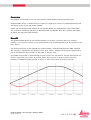
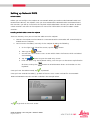
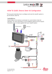
HOW TO GUIDE: Leica mojo3D – Network DGPS
Description
This document is designed to assist in setting up the Leica mojo3D to use network DGPS (differential
GPS) for improved position accuracy when the Leica mojo3D is configured as a stand-alone device
(no RTK device attached).
This ‘how to guide’ should be used in conjunction with the following documentation:
■
Leica mojo3D - user manual (v2.0 or above)
Limitations
It is advised that the Leica mojo3D is running the most recent version of software. The latest
version is available from http://www.AgGuidance.com/EducationCenter
Required Items
North
America
Article No.
Europe
Article No.
Australia /
Pacific
Article No.
South
America
Article No.
777535
777532
777532
6006419
Leica GeoPRO antenna
plus Network DGPS, OR
6006670
6006669
N/A
6006671
Leica GeoPRO antenna
plus GLONASS & Network
DGPS
6006674
6006672
6006675
Components
Leica mojo3D Kit
6006673
Network Data Plan
Contact
Dealer
Contact
Dealer
Contact
Dealer
Contact
Dealer
Network RTK or DGPS
correction stream
Contact
Dealer
Contact
Dealer
Contact
Dealer
Contact
Dealer
Version
Date
1.0
07Nov2011
Summary of Changes
Initial version
HOW TO GUIDE: Leica mojo3D - Network DGPS
Page 1/7 Document #
Checked and Authorized by:
JM
Overview
The mojo3D stand-alone system can now provide a DGPS (Differential GPS) position type.
Network DGPS utilizes a network of base stations or single base stations to provide differential GPS
correction signals via the cell phone network.
Before you can configure the mojo3D to use Network DGPS you need to obtain two unlock codes.
This is done by redeeming vouchers for Network DGPS and Network Data Plan. Contact your dealer
to obtain the required unlock vouchers.
Benefit
The Network DGPS option for the mojo3D provides an increase in accuracy over the standard
product. This accuracy increase is most pronounced in the absolute position and not so much in the
pass to pass.
The absolute accuracy of the mojo3D with network DGPS is reduced to 0.50 meters RMS, however
this accuracy is impacted by the distance to the base station. Excellent performance improvements
can be achieved with base stations in the order of 150 km away.
The below image shows a representation of two systems that are both on average drifting one unit
of cross track every 15 minutes, or in other words they have the same Pass to Pass accuracy.
However the DGPS corrected position in red has a much more accurate absolute position.
HOW TO GUIDE: Leica mojo3D - Network DGPS
Page 2/5 Version 1.0
Setting up Network DGPS
Unlock Codes
Before you can configure the mojo3D to use Network DGPS you need to unlock Network DGPS and
Network Data Plan on the mojo3D. Once you have redeemed the Network DGPS and Network Data
Plan vouchers you will be issued with the required unlock code/codes. Contact your dealer to obtain
unlock vouchers and refer to the mojo3D user manual for information on how to redeem unlock
vouchers.
Loading Unlock Codes onto the mojo3D
There are two ways that you can load the codes onto the mojo3D.
1. Connect the mojo3D to Virtual Wrench. Once connected the new codes will automatically be
loaded onto the mojo3D
2. You can enter the code(s) manually via the mojo3D by doing the following:
a. On the right hand side of the screen, tap the
button.
b. Then tap the
button
c. You will then see a feature status screen which shows the features which are locked
and unlocked.
d. Tap the
button to go to the code entry screen
e. Enter the code using the keyboard making sure that you use the correct capitalization
for letters and tap the
keyboard.
Once you have the code entered, tap
button to switch between letters and numbers on the
to proceed.
Once you have entered the code(s), go back to feature status screen and confirm that Network
DGPS and Network Data Plan are both unlocked. See example below.
Tap
to get back to the main screen.
HOW TO GUIDE: Leica mojo3D - Network DGPS
Page 3/5 Version 1.0
Enabling Network DGPS
NOTE: This step assumes that the mojo3D is already configured as a stand-alone mojo3D and that
Network DGPS and Network Data Plan are unlocked.
From the main screen, tap the
button followed by the
button. This will take you to the
correction source selection screen.
On the correction source selection screen tap the “Network DGPS” button so that it is blue (as in the
example below) and then the
button to progress.
Server and LogLog-in Details
By tapping on the entry boxes for Host, Port, Username and Password, enter in all the details (which
should have been supplied by your Network DGPS provider).
Tap the
button once you have all the details entered.
Select a Stream
Once you have details entered into the system the mojo3D will download a list of available data
streams from the Network server. When you select a stream from the list (by tapping the stream
name) you will get some information about the stream on the right hand side of the screen (see
example below). Types of streams that can be used include the following, RTK, DGPS, Network or
Single Point, GPS or GPS/GLONASS.
HOW TO GUIDE: Leica mojo3D - Network DGPS
Page 4/5 Version 1.0
NOTE:
NOTE the distance to the reference source shown on the right is a guide only and may be incorrect.
Some servers provide a virtual correction location which can only be assigned to a location close to
you once you have connected to the data stream. Until that time, the reported distance is
meaningless.
Tap the
and
buttons as required to scroll through the list of streams.
Once you have selected the appropriate stream for your location and configuration, tap the
button to progress.
Configuration Confirmation
If you have everything entered correctly the system will attempt to connect to the correction source.
This may take some time and if successful you will see a screen that looks like the one below.
If everything is ok, tap
or tap
to complete the Network DGPS configuration and begin using the system
to go back and make any changes. Alternatively, if the settings are not correct you can go
forwards and restart the configuration wizard.
When the mojo3D is running Network DGPS a network status icon similar to
will be shown in
status area (upper left) of the main screen.
Glossary
DGPS – Differential Global Positioning System, commonly used as a term to describe a GPS position
corrected by a base station to remove some of the common position errors.
Network DGPS – Network Differential Global Positioning System, commonly used as a term to
describe a GPS position corrected by a base station with the corrections provided from a network via
the internet to remove some of the common position errors.
RMS – Root Mean Squared, the root mean square is also known as the quadratic mean and is a
statistical measure of the magnitude of a varying quantity.
HOW TO GUIDE: Leica mojo3D - Network DGPS
Page 5/5 Version 1.0