1
Spectrum Technology Platform
Version 10.0 SP1
Geocode Latin America - API
Table of Contents
1 - GeocodeAddressGlobal for
Latin America
Input
Options
Output
5
12
22
2ReverseGeocodeAddressGlobal
Input
Options
Output
37
38
42
3 - Result Codes for
International Geocoding
International Street Geocoding Result Codes (S
Codes)
48
Interpreting S Result Codes
49
International Postal Geocoding Result Codes (Z
Codes)
50
International Geographic Geocoding Result Codes
(G Codes)
51
Reverse Geocoding Codes (R Codes)
51
Non-match Codes
52
1GeocodeAddressGlobal
for Latin America
The GeocodeAddressGlobal with the Latin America database provides
street-level geocoding for many Latin American countries. It can also
determine city or locality centroids, as well as postal code centroids for
selected countries.
These Latin American countries comprise the XL1 database. Enterprise
Geocoding Module Data Release Announcements will list and describe the
countries included with the Latin America database.
Note: The following Latin American countries are each licensed as a
separate databases and are not part of the Latin America database.
These are also documented separately.
Argentina
Bahamas
Brazil
Chile
Mexico
Uruguay
Venezuela
The Latin America database is an optional part of the Enterprise Geocoding
Module. For more information about Enterprise Geocoding Module, see
Enterprise Geocoding Module.
In this section
GeocodeAddressGlobal for Latin America
Input
Options
Output
Spectrum Technology Platform 10.0 SP1
5
12
22
Geocode Latin America - API
4
GeocodeAddressGlobal for Latin America
Input
GeocodeAddressGlobal with the Latin America database takes an address as input.
Input Fields
To obtain the best performance and the most possible matches, your input address lists should be
as complete as possible, free of misspellings and incomplete addresses, and as close to postal
authority standards as possible. Most postal authorities have websites that contain information about
address standards for their particular country.
NAVTEQ data is available for Latin America. For NAVTEQ data, note the following:
Data © 1987 - 2015 HERE. All rights reserved.
The following table lists the input fields used for geocoding locations in Latin America.
Note: Specify input using the DataTable class. For information on the DataTable class, see the
"API Fundamentals" section.
Table 1: Input Fields for Latin America
columnName
Description
AddressLine1
One of the following:
• For example:
Appeldam
Oranjestad
14th Street
San Ignacio
Radnor Drive
Hamilton
Calle 15
Santa Cruz de la Sierra
Bonnetts Road
Saint Michael
Ruta 125
40405 Santo Domingo
Spectrum Technology Platform 10.0 SP1
Geocode Latin America - API
5
GeocodeAddressGlobal for Latin America
columnName
Description
Calle 30
Ciudad de la Habana
Ruta 125
40405 Santo Domingo
Calle 30
Ciudad de la Habana
7 Avenida
Villa Nueva
North Road
Georgetown
Pasaje B San Pedro Sula
Queen Street 1
Kingston
39 Avenida NE
Managua
Avenida 4 De Julio
Ciudad de Panamá
Calle Felipe 101 31
Lima
Calle Padres Aguilar
San Salvador
Henrystraat 8
Paramaribo
Angelina
San Juan-Laventille
• This field can also contain the full address. For more information, see Single
Line Input on page 10
AddressLine2
City
The city or town name. Your input address should use the official city name.
County
The meaning of county varies by country.
The majority of countries in the Latin American database (XL1) do not use a
county or equivalent as part of an address.
• ABW (Aruba)—Not used
Spectrum Technology Platform 10.0 SP1
Geocode Latin America - API
6
GeocodeAddressGlobal for Latin America
columnName
Description
•
•
•
•
•
•
•
•
•
•
•
•
•
•
•
•
•
•
BLZ (Belize)—Not used
BMU (Bermuda)—Not used
BOL (Bolivia)—Not used
BRB (Barbados)—Not used
CRI (Costa Rica)—Not used
CUB (Cuba)—Not used
DOM (Dominican Republic)—Not used
ECU (Ecuador)—Not used
GTM (Guatemala)—Not used
GUY (Guyana)—Not used
HND (Honduras)—Not used
JAM (Jamaica)—Not used
KNA (St Kitts and Nevis)—Not used
PAN (Panama)—Not used
PER (Peru)—Not used
PRY (Paraguay)—Not used
SUR (Suriname)—Not used
TTO (Trinidad and Tobago)—Not used
This field is not used with countries included with the Latin American database
(Product Code XL1). These African countries generally have less comprehensive
address coverage.
FirmName
This field is not used with countries included with the Latin American database
(Product Code XL1). These countries generally have less comprehensive address
coverage.
HouseNumber
The building number. You may get better parsing results for some countries if
you put the house number in this field instead of AddressLine1. Not every country
includes house number data.
Some countries covered in the Latin America database have house number data.
See Address Guidelines for Latin America on page 9 for details of Latin
America house number and postal coverage.
Note: The house number specified in the HouseNumber field takes precedence
over any house number specified in the AddressLine1 field.
LastLine
The last line of the address.
•
Spectrum Technology Platform 10.0 SP1
Geocode Latin America - API
7
GeocodeAddressGlobal for Latin America
columnName
Description
Locality
The meaning of locality varies by country. Generally a locality is a village in rural
areas or it may be a suburb in urban areas. When used, a locality typically appears
on the lastline of the address with the postcode.
•
•
•
•
•
•
•
•
•
•
•
•
•
•
•
•
•
•
•
•
PostalCode
ABW (Aruba)—Not used
BLZ (Belize)—Not used
BMU (Bermuda)—Not used
BOL (Bolivia)—Not used
BRB (Barbados)—Not used
BRB (Barbados)—Not used
DOM (Dominican Republic)—Not used
ECU (Ecuador)—Not used
DOM (Dominican Republic)—Not used
ECU (Ecuador)—Not used
HND (Honduras)—Not used
JAM (Jamaica)—Not used
KNA (St Kitts and Nevis)—Not used
NIC (Nicaragua)—Not used
PAN (Panama)—Not used
PER (Peru)—Not used
NIC (Nicaragua)—Not used
PRY (Paraguay)—Not used
SUR (Suriname)—Not used
TTO (Trinidad and Tobago)—Not used
The postal code in the appropriate format for the country.
Some countries covered in the Latin America database have limited postal code
data. See Address Guidelines for Latin America on page 9 for details of Latin
America house number and postal coverage.
StateProvince
The meaning of State/Province varies by country.
Countries in the Africa, Middle East, and Latin America databases do not use a
state/province or equivalent as part of an address. However there is no penalty
if state/province is used in input address.
Spectrum Technology Platform 10.0 SP1
Geocode Latin America - API
8
GeocodeAddressGlobal for Latin America
Address Guidelines for Latin America
GeocodeAddressGlobal with the Latin America database provides street-level, city, or geographic
geocoding for many Latin American countries. These countries comprise the Latin America database
(Product Code XL1).
Follow these guidelines to provide input that GeocodeAddressGlobal can successfully geocode
Latin America addresses.
• Required fields—Addresses must contain a city.
• Supported languages—The geocoder supports the official language for each country.
• Thoroughfare types—Thoroughfare types and their common abbreviations are recognized and
fully supported on input and output.
• Common words and abbreviations—The geocoder recognizes common words, directionals,
house number indicators, and abbreviations used in addresses and can geocode these addresses
successfully.
Some Latin America countries have postcode data and some have house numbers. Postal geocoding
or house number matching at the street geocoding level is available if this data is available. The
following table lists the Latin America database countries and indicates the availability of postcode,
house numbers, and the native language for each country.
Table 2: Latin America Geocoding Support
Country (ISO)
Postcodes
House Numbers
Language
Aruba (ABW)
No
No
Dutch
Barbados (BRB)
No
No
English
Belize (BLZ)
No
No
English
Bermuda (BMU)
No
No
English
Bolivia (BOL)
No
No
Spanish
Costa Rica (CRI)
Yes
Yes
Spanish
Cuba (CUB)
No
No
Spanish
Dominican Republic (DOM)
Yes
No
Spanish
Spectrum Technology Platform 10.0 SP1
Geocode Latin America - API
9
GeocodeAddressGlobal for Latin America
Country (ISO)
Postcodes
House Numbers
Language
Ecuador (ECU)
No
Yes
Spanish
El Salvador (SLV)
No
No
Spanish
Guatemala (GTM)
No
No
Spanish
Guyana (GUY)
No
No
English
Honduras (HON)
No
No
Spanish
Jamaica (JAM)
Yes
No
Spanish
Nicaragua (NIC)
No
No
Spanish
Panama (PAN)
No
Yes
Spanish
Paraguay (PRY)
No
Yes
Spanish
Peru (PER)
Yes
Yes
Spanish
St. Kitts and Nevis (KNA)
No
No
Spanish
Suriname (SUR)
No
Yes
Dutch
Trinidad and Tobago (TTO)
No
No
Spanish
If the input includes a state/province or locality and that input is matched, it does contribute to a
higher candidate ranking. However, there is no penalty if state/province or locality is omitted or
unmatched.
Single Line Input
Instead of entering each address element in separate fields, you may enter the entire address in
the AddressLine1 input field.
For all countries except Japan, you can enter addresses in one or more of these single-line formats.
Note: Not all formats work may work for every country.
Spectrum Technology Platform 10.0 SP1
Geocode Latin America - API
10
GeocodeAddressGlobal for Latin America
StreetAddress;PostalCode;City
StreetAddress;City;PostalCode
StreetAddress;City
StreetAddress;City;StateProvince;PostalCode
StreetAddress;Locality
StreetAddress;County;City
PostalCode;StreetAddress
PostalCode;StreetAddress;City
City;PostalCode;StreetAddress
Where:
• StreetAddress can be house number and street name in either order (with street type immediately
before or after the street name).
• City is the city or town.
Note: Not all of these address elements are used in every country.
Other single-line formats may also be acceptable for many countries.
The matching accuracy for single line input is comparable to that of structured address input. The
performance of single line input addresses may be slightly slower than that of structured address
input.
For best results, use delimiters (comma, semicolon, or colon) between each address element. For
example,
Appeldam Oranjestad
14th Street San Ignacio
Radnor Drive Hamilton
Calle 15 Santa Cruz de la Sierra
Bonnetts Road Saint Michael
Ruta 125 40405 Santo Domingo
Calle 30 Ciudad de la Habana
Calle 7 71101 San Cristobal
Hermano Miguel 2 Quito
7 Avenida Villa Nueva
North Road Georgetown
Pasaje B San Pedro Sula
Spectrum Technology Platform 10.0 SP1
Geocode Latin America - API
11
GeocodeAddressGlobal for Latin America
Queen Street 1 Kingston
Wellington Road St. Peter Basseterre
39 Avenida NE Managua
Avenida 4 De Julio Ciudad de Panamá
Calle Felipe 101 31 Lima
Artigas 2801 Asunción
Calle Padres Aguila, San Salvador
Henrystraat 8 Paramaribo
Angelina San Juan-Laventille
Punctuation is ignored for geocoding purposes.
Guidelines for Single Line Input
• Punctuation is generally ignored, however you may improve results and performance by using
separators (commas, semicolons, etc.) between different address elements.
• The country is not required. Each country geocoder assumes that the address is in its country.
• Firm information (placename, building name, or government building) is returned if available.
Options
GeocodeAddressGlobal allows you to set default processing options through the Management
Console. You can override certain settings for individual calls to GeocodeAddressGlobal using the
API or Spectrum™ Technology Platform client tools, such as Enterprise Designer.
Geocoding Options
The following table lists the options that control how a location's coordinates are determined.
Table 3: Geocoding Options for Latin America
optionName
Description
GeocodeLevel
Specifies how precisely you want to geocode addresses. One of the following:
Spectrum Technology Platform 10.0 SP1
Geocode Latin America - API
12
GeocodeAddressGlobal for Latin America
optionName
Description
StreetAddress
The geocoder attempts to geocode addresses to a street
address, but some matches may end up at a less precise
location such as a postal code centroid, intersection, or
shape path.
PostalCentroid
GeographicCentroid
Interpolation
FallbackToGeographic
FallbackToPostal
OffsetFromStreet
The geocoder attempts to geocode addresses to the
geographic centroid of a city or state.
Y
Yes, perform address point interpolation.
N
No, do not perform address point interpolation.
Specifies whether to attempt to determine a geographic region centroid when an
address-level geocode cannot be determined.
Y
Yes, determine a geographic centroid when an address-level centroid
cannot be determined. Default.
N
No, do not determine a geographic centroid when an address-level
centroid cannot be determined.
Y
Yes, determine a postal code centroid when an address-level centroid
cannot be determined. Default.
N
No, do not determine a postal code centroid when an address-level
centroid cannot be determined.
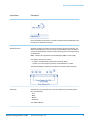
Indicates the offset distance from the street segments to use in street-level
geocoding. The distance is specified in the units you specify in the OffsetUnits
option.
The default value varies by country. For most countries, the default is 7 meters.
The offset distance is used in street-level geocoding to prevent the geocode from
being in the middle of a street. It compensates for the fact that street-level geocoding
returns a latitude and longitude point in the center of the street where the address
is located. Since the building represented by an address is not on the street itself,
you do not want the geocode for an address to be a point on the street. Instead,
you want the geocode to represent the location of the building which sits next to
the street. For example, an offset of 50 feet means that the geocode will represent
a point 50 feet back from the center of the street. The distance is calculated
perpendicular to the portion of the street segment for the address. Offset is also
used to prevent addresses across the street from each other from being given the
Spectrum Technology Platform 10.0 SP1
Geocode Latin America - API
13
GeocodeAddressGlobal for Latin America
optionName
Description
same point. The following diagram shows an offset point in relation to the original
point.
Street coordinates are accurate to 1/10,000 of a degree and interpolated points
are accurate to the millionths of a degree.
OffsetFromCorner
Specifies the distance to offset the street end points in street-level matching. The
distance is specified in the units you specify in the OffsetUnits option.This value
is used to prevent addresses at street corners from being given the same geocode
as the intersection.
Note: Offset is not supported for the United Kingdom (GBR) or Japan (JPN).
The default value varies by country:
• 12 meters—Australia (AUS), Austria (AUT), Germany (DEU)
• 7 meters—For other supported countries, the default offset is 7 meters.
The following diagram compares the end points of a street to offset end points.
OffsetUnits
Specifies the unit of measurement for the street offset and corner offset options.
One of the following:
•
•
•
•
Feet
Miles
Meters
Kilometers
The default is Meters.
Spectrum Technology Platform 10.0 SP1
Geocode Latin America - API
14
GeocodeAddressGlobal for Latin America
optionName
Description
CoordinateSystem
A coordinate system is a reference system for the unique location of a point in
space. Cartesian (planar) and Geodetic (geographical) coordinates are examples
of reference systems based on Euclidean geometry. Spectrum™ Technology
Platform supports systems recognized by the European Petroleum Survey Group
(EPSG).
Each country supports different coordinate systems. Depending on the country,
you have one or more of the following options:
IncludeInputs
Specifies whether to return the formatted input street address and each input
address element in a separate field. This feature can help you understand how the
input address was parsed and identify specific input elements that could not be
geocoded. For example, a returned HouseNumber.Input could contain an invalid
house number in your input address.
You can specify parsed input returns for a specific country. For example, a REST
API example for Canada is:
Option.CAN.IncludeInputs=Y
Note: Data vintage must be 2014 Q4 or newer to get Parsed Address Input
returns. Also note that Parsed Address Input elements are not returned
for every country.
Parsed Address Input elements are returned in separately labeled fields names
with a .Input extension. For example:
•
•
•
•
•
•
•
•
FormattedInputStreet.Input
City.Input
Country.Input
HouseNumber.Input
Locality.Input
PostalCode.Base.Input
StreetName.Input
StreetSuffix.Input
Other labeled fields are possible depending on the input address, country, and
data source.
Note: Parsed Address Input elements are not returned for every country. Also,
because Geocode Address World geocodes to the geographic or postal
level only (not street address), this does not return Parsed Address Input
For many countries, if part of the input address could not be recognized as a
specific address element, this content is returned in UnparsedWords.Input.
For intersection addresses, the first entered street is returned in StreetName.Input
and the second entered street name is returned in IntersectionStreet2.Input.
Spectrum Technology Platform 10.0 SP1
Geocode Latin America - API
15
GeocodeAddressGlobal for Latin America
Matching Options
Matching options let you set match restrictions, fallback, and multiple match settings so that the
matching can be as strict or relaxed as you need. The strictest matching conditions require an exact
match on house number, street name, postal code and no fallback to postal code centroids. The
geocoder looks for an exact street address match within the postal code in the input address.
Relaxing the conditions broadens the area in which it searches for a match. For example, by relaxing
the postal code, the geocoder searches for candidates outside the postal code but within the city
of your input address.
Table 4: Matching Options for Latin America
optionName
Description
KeepMultimatch
Specifies whether to return results when the address matches to multiple candidates
in the database. If this option is not selected, an address that results in multiple
candidates will fail to geocode.
If you select this option, specify the maximum number of candidates to return using
the MaxCandidates option (see below).
Y
Yes, return candidates when multiple candidates are found. Default.
N
No, do not return candidates. Addresses that result in multiple candidates
will fail to geocode.
MaxCandidates
If you specify KeepMultimatch=Y, this option specifies the maximum number of results
to return. The default is 1. Specify -1 (minus one) to return all possible candidates.
ReturnRanges
Specifies whether to return address range information. If you enable this option, the
output field Ranges will be included in the output.
A range is a series of addresses along a street segment. For example, 5400-5499
Main St. is an address range representing addresses in the 5400 block of Main St. A
range may represent just odd or even addresses within a segment, or both odd and
even addresses. A range may also represent a single building with multiple units,
such as an apartment building.
MaxRanges
Spectrum Technology Platform 10.0 SP1
Y
Yes, return address range information.
N
No, do not return address range information. Default.
If you choose to return ranges, this option specifies the maximum number of ranges
to return for each candidate. Since the geocoder returns one candidate per segment,
Geocode Latin America - API
16
GeocodeAddressGlobal for Latin America
optionName
Description
and since a segment may contain multiple ranges, this option allows you to see the
other ranges in a candidate's segment.
MaxRangeUnits
If you choose to return ranges, this option specifies the maximum number of units
(for example, apartments or suites) to return for each range.
For example, if you were to geocode an office building at 65 Main St. containing four
suites, there would be a maximum of four units returned for the building's range (65
Suite 1, 65 Suite 2, 65 Suite 3, and 65 Suite 4. If you were to specify a maximum
number of units as 2, then only two units would be returned instead of all four.
CloseMatchesOnly
MatchMode
MustMatchInput
MustMatchHouseNumber
Spectrum Technology Platform 10.0 SP1
Specifies whether to return only those geocoded results that are close match
candidates. For example, if there are 10 candidates and two of them are close
candidates, and you enable this option, only the two close matching candidates would
be returned instead of all 10. To specify what is considered a close match, use the
MustMatch options. Address candidates are ranked according to how closely the
input address matches these preferences.
Y
Yes, return only close matches.
N
No, do not return only close matches. Default.
Specifies how to determine whether a candidate is a close match. One of the following:
CustomMode
This option allows you to specify which parts of a candidate
address must match the input address to be considered a close
match. Use the MustMatch<Element> options to specify the
address elements you want.
RelaxedMode
All candidate addresses are considered a close match.
Specifies whether candidates must match all non-blank input fields to be considered
a close match. For example, if an input address contains a city and postal code, then
candidates for this address must match the city and postal code to be considered a
close match.
Y
Yes, a candidate must match all input to be considered a close match.
N
No, a candidate does not have to match all input to be considered a close
match. Default.
Some countries covered in the Latin America database have house number data.
See Address Guidelines for Latin America on page 9 for details of Latin America
house number and postal coverage.
Geocode Latin America - API
17
GeocodeAddressGlobal for Latin America
optionName
MustMatchStreet
MustMatchLocality
MustMatchCity
Spectrum Technology Platform 10.0 SP1
Description
Y
Yes, a candidate must match the house number to be considered a close
match.
N
No, a candidate does not have to match the house number to be
considered a close match.
Y
Yes, a candidate must match the street name to be considered a close
match.
N
No, a candidate does not have to match the street name to be considered
a close match.
•
•
•
•
•
•
•
•
•
•
•
•
•
•
•
•
•
•
•
•
•
ABW (Aruba)—Not used
BLZ (Belize)—Not used
BMU (Bermuda)—Not used
BOL (Bolivia)—Not used
BRB (Barbados)—Not used
CRI (Costa Rica)—Not used
CUB (Cuba)—Not used
DOM (Dominican Republic)—Not used
ECU (Ecuador)—Not used
GTM (Guatemala)—Not used
GUY (Guyana)—Not used
HND (Honduras)—Not used
JAM (Jamaica)—Not used
KNA (St Kitts and Nevis)—Not used
NIC (Nicaragua)—Not used
PAN (Panama)—Not used
PER (Peru)—Not used
PRY (Paraguay)—Not used
SLV (El Salvador)—Not used
SUR (Suriname)—Not used
TTO (Trinidad and Tobago)—Not used
Y
Yes, a candidate must match the locality to be considered a close match.
N
No, a candidate does not have to match the locality to be considered a
close match.
Y
Yes, a candidate must match the city to be considered a close match.
N
No, a candidate does not have to match the city to be considered a close
match.
Geocode Latin America - API
18
GeocodeAddressGlobal for Latin America
optionName
Description
MustMatchCounty
Specifies whether candidates must match the county (or equivalent) to be considered
a close match. The meaning of county varies for different countries.
The majority of countries in the Latin American database (XL1) do not use a county
or equivalent as part of an address.
•
•
•
•
•
•
•
•
•
•
•
•
•
•
•
•
•
•
•
•
•
•
ABW (Aruba)—Not used
BLZ (Belize)—Not used
BMU (Bermuda)—Not used
BOL (Bolivia)—Not used
BRB (Barbados)—Not used
CRI (Costa Rica)—Not used
CUB (Cuba)—Not used
DOM (Dominican Republic)—Not used
ECU (Ecuador)—Not used
GTM (Guatemala)—Not used
GUY (Guyana)—Not used
HND (Honduras)—Not used
JAM (Jamaica)—Not used
KNA (St Kitts and Nevis)—Not used
NIC (Nicaragua)—Not used
PAN (Panama)—Not used
PER (Peru)—Not used
PRY (Paraguay)—Not used
SLV (El Salvador)—Not used
SUR (Suriname)—Not used
TTO (Trinidad and Tobago)—Not used
TTO (Trinidad and Tobago)—Not used
One of the following:
MustMatchStateProvince
Y
Yes, a candidate must match the county to be considered a close match.
N
No, a candidate does not have to match the county to be considered a
close match.
Specifies whether candidates must match the state or province (or equivalent) to be
considered a close match.
• SLV (El Salvador)—Not used
• TTO (Trinidad and Tobago)—Not used
One of the following:
Spectrum Technology Platform 10.0 SP1
Y
Yes, a candidate must match the state or province to be considered a
close match.
N
No, a candidate does not have to match the state or province to be
considered a close match.
Geocode Latin America - API
19
GeocodeAddressGlobal for Latin America
optionName
Description
MustMatchPostalCode
Some countries covered in the Latin America database have postal code data. See
Address Guidelines for Latin America on page 9 for details of Latin America
house number and postal coverage.
SortCandidatesUsingLocale
Y
Yes, a candidate must match the postal code to be considered a close
match.
N
No, a candidate does not have to match the postal code to be considered
a close match.
This is a Reverse geocoding option that applies to Greece, Russia, Ukraine, and any
other country that supports dual character sets (such as the Middle East countries).
Specifies whether candidates are sorted and returned based on the input language.
That is, if the input was in Russian, the Russian character candidate is returned first
followed by the English language candidate. This will override the dictionary order.
Y
Yes, candidates are sorted and returned based on input language.
N
No, candidates are returned in the order that the dictionary was added to
the database, regardless of input language.
You may want to use a balanced strategy between match rate and geographic precision. That is,
you may want to geocode as many records as possible automatically, but at the same time want to
minimize the number of weaker matches (false positives). For example, false positives can occur
when the geocoder:
• finds a street that sounds like the input street.
• finds the same street in another city (if postal code match is not required).
• finds the street but with a different house number (if house number is not required).
The following settings may achieve a good balance between match rate and precision:
•
•
•
•
CloseMatchesOnly—Specify "Y".
MustMatchHouseNumber—Specify "Y".
MustMatchStreet—Specify "Y".
FallbackToPostal—Specify "N".
Data Options
The Data tab allows you to specify which databases to use in geocoding. Databases contain the
address and geocode data necessary to determine the geocode for a given address. There are two
kinds of databases: standard databases and custom databases. Standard databases are those
supplied by Pitney Bowes and based on address and geocoding data from postal authorities and
Spectrum Technology Platform 10.0 SP1
Geocode Latin America - API
20
GeocodeAddressGlobal for Latin America
suppliers of geographical data. Custom databases are databases you create to enhance or augment
standard databases for your particular needs.
The following table lists the options available for specifying which databases to use and the search
order of databases.
Table 5: Data Options for Latin America
optionName
Description
Database
Specifies the database to be used for geocoding. Only databases that have been
defined in the Databases Resources panel in the Management Console are available.
DatabasePreference
Specifies which geocoding databases to use. One of the following:
PreferCustom
Use both standard databases and custom databases, but
give preference to candidates from custom databases. Use
this option if you feel your custom database is superior to the
standard database.
PreferStandard
Use both standard databases and custom databases, but
give preference to candidates from standard databases.
CustomOnly
Use only custom databases. Ignore standard databases.
StandardOnly
Use only standard databases. Ignore custom databases.
Both
Use both standard databases and custom databases. In cases
where candidates are returned from both, the standard
database is preferred. Default.
The results from a custom database have a "U" at the end of the result code. Results
from an address database have an "A" at the end of the match score. For example:
S5HPNTSCZA is a match score that comes from an address database, while
S5HPNTSCZU comes from a custom database. For more information, see Result
Codes for International Geocoding on page 47.
DatabaseSearchOrder
The name of one or more database resources to use in the search process. Use
the database name specified in the Management Console's Database Resources
tool.
You can specify multiple database resources. If you specify more than one database,
list them in order of preference.
The order of the databases has an effect when there are close match candidates
from different databases. The close matches that are returned come from the
database that is first in the search list. Close matches from lower ranked databases
are demoted to non-close matches.
You can also use the order of the databases to perform fallback processing if you
have an both an address point database and a street-level database installed for
Spectrum Technology Platform 10.0 SP1
Geocode Latin America - API
21
GeocodeAddressGlobal for Latin America
optionName
Description
the country. List the address point database first and the street database second.
If the address cannot be geocoded to the address point level, the geocoder will
attempt to geocode it to the street level.
Output Data Options
The following table lists the options that control which data is returned in the output.
Table 6: Output Data Options
optionName
Description
ReturnOnlySimilarFirmNames
This option applies to the U.K. only.
Specifies whether to return firm names only when the input firm name is similar to
the firm name in the geocoding database. For example, if the input firm name is
"Pitney Bowes" but the geocoding database returns "Pitney Bowes Software, Inc.",
these two firm names are not similar. In most cases the input firm name must match
the firm name in the database exactly. Some differences in abbreviations are
considered similar enough to result in the firm name being returned.
Y
Yes, return only firm names that are similar to the input firm name.
N
No, return firm names regardless of whether they are close to the input
firm name. Default.
Output
The geocoder returns the latitude/longitude, standardized address, and result indicators. Result
indicators describe how well the geocoder matched the input address to a known address and
assigned a location; they also describe the overall status of a match attempt. T
Spectrum Technology Platform 10.0 SP1
Geocode Latin America - API
22
GeocodeAddressGlobal for Latin America
Geocode Output
Table 7: Geocode Output for Latin America
columnName
Description
CoordinateSystem
The coordinate system used to determine the latitude and longitude coordinates. A
coordinate system specifies a map projection, coordinate units, etc. An example is
EPSG:4326. EPSG stands for European Petroleum Survey Group.
Latitude
Seven-digit number in degrees and calculated to four decimal places (in the format
specified).
Longitude
Seven-digit number in degrees and calculated to four decimal places (in the format
specified).
Address Output
The address may be identical to the input address if the input address was accurate, or it may be
a standardized version of the input address, or it may be a candidate address when multiple matches
are found.
Table 8: Address Output for Latin America
columnName
Description
AddressLine1
First line of the address.
AddressLine2
Second line of the address.
ApartmentLabel
The type of unit, such as apartment, suite, or lot.
Spectrum Technology Platform 10.0 SP1
Geocode Latin America - API
23
GeocodeAddressGlobal for Latin America
columnName
Description
ApartmentLabel.Input
The type of unit, such as apartment, suite, or lot as it was input.
ApartmentNumber
Unit number.
ApartmentNumber.Input
Unit number as it was input
City
The name.
City.Input
The name as it was input. For Japan, the municipality subdivision (sub-city)
Country
The three-letter ISO 3166-1 Alpha 3 country code.
For Aruba, the country code is ABW
For Belize, the country code is BLZ
For Bermuda, the country code is BMU
For Bolivia, the country code is BOL
For Barbados, the country code is BRB
For Costa Rica, the country code is CRI
For Cuba, the country code is CUB
For Dominican Republic, the country code is DOM
For Ecuador, the country code is ECU
For Guatemala, the country code is GTM
For Guyana, the country code is GUY
For Honduras, the country code is HND
For Jamaica, the country code is JAM
For Saint Kitts and Nevis, the country code is KNA
For Nicaragua, the country code is NIC
For Panama, the country code is PAN
For Peru, the country code is PER
For Paraguay, the country code is PRY
For El Salvador, the country code is SLV
For Suriname, the country code is SUR
For Trinidad and Tobago, the country code is TTO
Spectrum Technology Platform 10.0 SP1
Geocode Latin America - API
24
GeocodeAddressGlobal for Latin America
columnName
Description
Addresses for countries that do not have a dedicated geocoding stage return the
country code associated with the input address. For example, Vatican City
addresses return VAT in the Country field, regardless of whether VAT or ITA (Italy)
was passed as the country code. Similarly, addresses in Martinique return MTQ
(rather than FRA) in the Country field.
Country.Input
The three-letter ISO 3166-1 Alpha 3 country code as it was input.
For Aruba, the country code is ABW
For Belize, the country code is BLZ
For Bermuda, the country code is BMU
For Bolivia, the country code is BOL
For Barbados, the country code is BRB
For Costa Rica, the country code is CRI
For Cuba, the country code is CUB
For Dominican Republic, the country code is DOM
For Ecuador, the country code is ECU
For Guatemala, the country code is GTM
For Guyana, the country code is GUY
For Honduras, the country code is HND
For Jamaica, the country code is JAM
For Saint Kitts and Nevis, the country code is KNA
For Nicaragua, the country code is NIC
For Panama, the country code is PAN
For Peru, the country code is PER
For Paraguay, the country code is PRY
For El Salvador, the country code is SLV
For Suriname, the country code is SUR
For Trinidad and Tobago, the country code is TTO
Addresses for countries that do not have a dedicated geocoding stage return the
country code associated with the input address. For example, Vatican City
addresses return VAT in the Country field, regardless of whether VAT or ITA (Italy)
was passed as the country code. Similarly, addresses in Martinique return MTQ
(rather than FRA) in the Country field.
County
The meaning of county varies by country.
The majority of countries in the Latin American database (XL1) do not use a county
or equivalent as part of an address.
Spectrum Technology Platform 10.0 SP1
Geocode Latin America - API
25
GeocodeAddressGlobal for Latin America
columnName
Description
•
•
•
•
•
•
•
•
•
•
•
•
•
•
•
•
•
•
•
ABW (Aruba)—Not used
BLZ (Belize)—Not used
BMU (Bermuda)—Not used
BOL (Bolivia)—Not used
BRB (Barbados)—Not used
CRI (Costa Rica)—Not used
CUB (Cuba)—Not used
DOM (Dominican Republic)—Not used
ECU (Ecuador)—Not used
GTM (Guatemala)—Not used
GUY (Guyana)—Not used
HND (Honduras)—Not used
JAM (Jamaica)—Not used
KNA (St Kitts and Nevis)—Not used
PAN (Panama)—Not used
PER (Peru)—Not used
PRY (Paraguay)—Not used
SUR (Suriname)—Not used
TTO (Trinidad and Tobago)—Not used
This field is not used with countries included with the Latin American database
(Product Code XL1). These African countries generally have less comprehensive
address coverage.
County.Input
The county name, or equivalent, as it was input. The meaning of county varies by
country.
The majority of countries in the Latin American database (XL1) do not use a county
or equivalent as part of an address.
•
•
•
•
•
•
•
•
•
•
•
•
•
•
•
•
Spectrum Technology Platform 10.0 SP1
ABW (Aruba)—Not used
BLZ (Belize)—Not used
BMU (Bermuda)—Not used
BOL (Bolivia)—Not used
BRB (Barbados)—Not used
CRI (Costa Rica)—Not used
CUB (Cuba)—Not used
DOM (Dominican Republic)—Not used
ECU (Ecuador)—Not used
GTM (Guatemala)—Not used
GUY (Guyana)—Not used
HND (Honduras)—Not used
JAM (Jamaica)—Not used
KNA (St Kitts and Nevis)—Not used
PAN (Panama)—Not used
PER (Peru)—Not used
Geocode Latin America - API
26
GeocodeAddressGlobal for Latin America
columnName
Description
• PRY (Paraguay)—Not used
• SUR (Suriname)—Not used
• TTO (Trinidad and Tobago)—Not used
This field is not used with countries included with the Latin American database
(Product Code XL1). These African countries generally have less comprehensive
address coverage.
FirmName
Name of the company or a place name.
FirmName.Input
Name of the company or a place name as it was input.
FormattedInputStreet.Input
The street as it was input.
Geocoder.MatchCode
HouseNumber
The number for the matched location.
HouseNumber.Input
The number for the matched location as it was input
HouseNumberHigh
The highest house number of the range in which the address resides.
HouseNumberLow
The lowest house number of the range in which the address resides.
HouseNumberParity
Indicates if the house number range contains even or odd numbers or both.
IntersectionStreet2.Input
Spectrum Technology Platform 10.0 SP1
E
Even
O
Odd
B
Both
U
Unknown
The second street in an intersection address as it was input.
Geocode Latin America - API
27
GeocodeAddressGlobal for Latin America
columnName
IsCloseMatch
Description
Indicates whether candidate is a close match.
Language
For reverse geocoded candidates, the two-character language code is returned.
LastLine
Complete last address line (city, state/province, and postal code).
Latitude
Latitude of the candidate.
LeadingDirectional
Street directional that precedes the street name. For example, the N in 138 N Main
Street.
LeadingDirectional.Input
Street directional that precedes the street name as it was input.
Locality
The meaning of locality varies by country. Generally a locality is a village in rural
areas or it may be a suburb in urban areas. When used, a locality typically appears
on the lastline of the address with the postcode.
•
•
•
•
•
•
•
•
•
•
•
•
•
•
•
•
•
•
•
•
Spectrum Technology Platform 10.0 SP1
ABW (Aruba)—Not used
BLZ (Belize)—Not used
BMU (Bermuda)—Not used
BOL (Bolivia)—Not used
BRB (Barbados)—Not used
BRB (Barbados)—Not used
DOM (Dominican Republic)—Not used
ECU (Ecuador)—Not used
DOM (Dominican Republic)—Not used
ECU (Ecuador)—Not used
HND (Honduras)—Not used
JAM (Jamaica)—Not used
KNA (St Kitts and Nevis)—Not used
NIC (Nicaragua)—Not used
PAN (Panama)—Not used
PER (Peru)—Not used
NIC (Nicaragua)—Not used
PRY (Paraguay)—Not used
SUR (Suriname)—Not used
TTO (Trinidad and Tobago)—Not used
Geocode Latin America - API
28
GeocodeAddressGlobal for Latin America
columnName
Locality.Input
Description
The locality as it was input.
•
•
•
•
•
•
•
•
•
•
•
•
•
•
•
•
•
•
•
•
ABW (Aruba)—Not used
BLZ (Belize)—Not used
BMU (Bermuda)—Not used
BOL (Bolivia)—Not used
BRB (Barbados)—Not used
BRB (Barbados)—Not used
DOM (Dominican Republic)—Not used
ECU (Ecuador)—Not used
DOM (Dominican Republic)—Not used
ECU (Ecuador)—Not used
HND (Honduras)—Not used
JAM (Jamaica)—Not used
KNA (St Kitts and Nevis)—Not used
NIC (Nicaragua)—Not used
PAN (Panama)—Not used
PER (Peru)—Not used
NIC (Nicaragua)—Not used
PRY (Paraguay)—Not used
SUR (Suriname)—Not used
TTO (Trinidad and Tobago)—Not used
LocationPrecistion
.
Longitude
Longitude of the candidate.
NumberOfCandidateRanges
Indicates the number of ranges of which the candidate is a member. A candidate
may be a part of multiple ranges if the candidate is a street instead of a building.
To specify the number of ranges to return for each candidate, use the MaxRanges
option.
NumberOfRangeUnits
Indicates the number of units included in the range. A unit is an address within a
building, such as an apartment or office suite. To specify the number of units to
return for each range, use the MaxRangeUnits option.
PostalCode
The postcode for the address. The format of the postcode varies by country.
Postcode data is not available for every country.
Spectrum Technology Platform 10.0 SP1
Geocode Latin America - API
29
GeocodeAddressGlobal for Latin America
columnName
Description
PostalCode.Addon
The second part of a postcode. This field is not used by most countries.
PostalCode.Addon.Input
The second part of a postcode as it was input. This field is not used by most
countries.
PostalCode.Base
The first part of a postcode. This field is not used by most countries.
PostalCode.Base.Input
The first part of a postcode. This field is not used by most countries.
PreAddress
Miscellaneous information that appears before the street name.
PrivateMailbox
This field is not currently used.
Ranges
This is a list field containing the address ranges that exist on the street segment
where the candidate address is located.
A range is a series of addresses along a street segment. For example, 5400-5499
Main St. is an address range representing addresses in the 5400 block of Main St.
A range may represent just odd or even addresses within a segment, or both odd
and even addresses. A range may also represent a single building with multiple
units, such as an apartment building.
The Ranges field contains the following sub-fields:
Spectrum Technology Platform 10.0 SP1
Address
This is a list filed that contains sub-fields for any
address elements (AddressLine1, City, and so on)
that are different from the candidate's address.
AdditionalFields
A listing of country-specific information related to the
address. The information contained in
AdditionalFields varies by country.
HouseNumberHigh
The highest address number for the range.
HouseNumberLow
The lowest address number for the range.
SegmentParity
Indicates the side of the street where the range is
located. One of the following:
Geocode Latin America - API
0
It is not known which side of the street the
range is located on.
1
The range is on the left side of the street.
2
The range is on the right side of the street.
30
GeocodeAddressGlobal for Latin America
columnName
Description
HouseNumberParity
Indicates whether the range contains odd or even
address numbers. One of the following:
0
The range contains both odd and even
address numbers.
1
The range contains odd address numbers
2
The range contains even address numbers.
-1
It is not known whether the range contains
odd or even house numbers.
TotalRangeUnitsReturned The number of unit ranges returned for the address.
A unit is an address within a building, such as an
apartment or suite.
RangeUnits
A list of the ranges of units within the building. An
example of units are apartments or suites.
Address
This is a list filed that contains
sub-fields for any address
elements (AddressLine1, City,
and so on) that are different from
the candidate's address.
UnitNumberHigh The highest unit number.
UnitNumberLow The lowest unit number.
SegmentCode
A unique ID that identifies .
SegmentParity
Indicates which side of the street has odd numbers.
StateProvince
L
Left side of the street
R
Right side of the street
B
Both sides of the street
U
Undetermined
The meaning of State/Province varies by country.
Countries in the Africa, Middle East, and Latin America databases do not use a
state/province or equivalent as part of an address. However there is no penalty if
state/province is used in input address.
Spectrum Technology Platform 10.0 SP1
Geocode Latin America - API
31
GeocodeAddressGlobal for Latin America
columnName
Description
StreetDataType
The default search order rank of the database used to geocode the address. A
value of "1" indicates that the database is first in the default search order, "2"
indicates that the database is second in the default search order, and so on.
The default database search order is specified in the Management Console with
the Database Resources tool.
StreetName
For most countries, this contains the street name.
StreetPrefix
The type of street when the street type appears before the base street name.
StreetSuffix
The type of street when the street type appears after the base street name.
TrailingDirectional
Street directional that follows the street name.
UnitNumberHigh
The highest unit number of the range in which the unit resides.
UnitNumberLow
The lowest unit number of the range in which the unit resides.
Return Parsed Address
The formatted input address can be returned along with a separate returned field
for each input address element. Parsed Address Input elements are returned in
separately labeled fields names with a .Input extension. See the Return Parsed
Address Geocoding Option for more information.
Result Codes
Result codes contain information about the success or failure of the geocoding attempt, as well as
information about the accuracy of the geocode.
Spectrum Technology Platform 10.0 SP1
Geocode Latin America - API
32
GeocodeAddressGlobal for Latin America
Table 9: Result Code Output for Latin America
columnName
Description
Geocoder.MatchCode
Indicates how closely the input address matches the candidate address.
IsCloseMatch
Indicates whether or not the address is considered a close match. An address is
considered close based on the "Close match criteria" options on the Matching tab.
MultiMatchCount
Y
Yes, the address is a close match.
N
No, the address is not a close match.
For street address geocoding, the number of matching address positions found for
the specified address.
For intersection geocoding, the number of matching street intersection positions
found for the specified addresses.
Status
Status.Code
Reports the success or failure of the match attempt
null
Success
F
Failure
If the geocoder could not process the address, this field will show the reason.
•
•
•
•
•
•
•
Status.Description
Spectrum Technology Platform 10.0 SP1
Internal System Error
No Geocode Found
Insufficient Input Data
Multiple Matches Found
Exception occurred
Unable to initialize Geocoder
No Match Found
If the geocoder could not process the address, this field will show a description of
the failure.
Problem + explanation
Returned when Status.Code = Internal System
Error.
Geocoding Failed
Returned when Status.Code = No Geocode
Found.
No location returned
Returned when Status.Code = No Geocode
Found.
Geocode Latin America - API
33
GeocodeAddressGlobal for Latin America
columnName
Description
No Candidates Returned
The geocoder could not identify any candidate
matches for the address.
Multiple Candidates Returned The address resulted in multiple candidates. In
and Keep Multiple Matches
order for the candidate address to be returned,
not selected
you must specify KeepMultimatch=Y.
LocationPrecision
A code describing the precision of the geocode. One of the following:
0
No coordinate information is available for this candidate
address.
1
Interpolated street address.
2
Street segment midpoint.
3
Postal code 1 centroid.
4
Partial postal code 2 centroid.
5
Postal code 2 centroid.
6
Intersection.
7
Point of interest. This is a placeholder value. Spectrum
databases do not have POI data, so it is not possible to get
this return.
8
State/province centroid.
9
County centroid.
10
City centroid.
11
Locality centroid.
12 - 15
For most countries, LocationPrecision codes 12 through 15
(LocationPrecision are reserved for unspecified custom items.
codes)
Spectrum Technology Platform 10.0 SP1
13
Additional point precision for unspecified custom item.
14
Additional point precision for unspecified custom item.
15
Additional point precision for unspecified custom item.
16
The result is an address point.
17
The result was generated by using address point data to
modify the candidates segment data.
18
The result is an address point that was projected using the
centerline offset feature. You must have both a point and a
street range database to use the centerline offset feature, and
thereby return LocationPrecision 18.
Geocode Latin America - API
34
GeocodeAddressGlobal for Latin America
columnName
Description
StreetDataType
The default search order rank of the database used to geocode the address. A value
of "1" indicates that the database is first in the default search order, "2" indicates
that the database is second in the default search order, and so on.
The default database search order is specified in the Management Console with the
Database Resources tool.
Spectrum Technology Platform 10.0 SP1
Geocode Latin America - API
35
2ReverseGeocodeAddressGlobal
ReverseGeocodeAddressGlobal determines the address for a given
latitude/longitude point. ReverseGeocodeAddressGlobal can determine
addresses in many countries. The countries available to you depends on
which country databases you have installed. For example, if you have
databases for Canada, Italy, and Australia installed,
ReverseGeocodeAddressGlobal would be able to geocode addresses in
these countries in a single stage.
Note: ReverseGeocodeAddressGlobal does not support U.S. addresses.
To geocode U.S. addresses, you must use
ReverseGeocodeUSLocation. That performs reverese geocoding
specifically for USA addresses.
Before you can work with ReverseGeocodeAddressGlobal, you must define
a global database resource containing a database for one or more countries.
Once you create the database resource, a ReverseGeocodeAddressGlobal
will become available in the Management Console, Enterprise Designer,
and Interactive Driver.
In this section
Input
Options
Output
37
38
42
ReverseGeocodeAddressGlobal
Input
ReverseGeocodeAddressGlobal takes longitude and latitude as input.
For GRC, RUS, and JPN, the user's locale determines the language of the returned candidates for
reverse geocoding. This can be Greek, Russian, or Japanese for GRC, RUS, and JPN respectively.
English is the default locale.
Note: Specify input using the DataTable class. For information on the DataTable class, see the
"API Fundamentals" section.
Table 10: ReverseGeocodeGlobal Input
columnName
Format
Description
Latitude
String
The latitude of the point for which you want address information.
Longitude
String
The longitude of the point for which you want address information.
Country
String
One of the following:
• The name of the country in English.
• The two-character ISO 3116-1 alpha-2 country code.
• The three-character ISO 3116-1 alpha-3 country code.
Spectrum Technology Platform 10.0 SP1
Geocode Latin America - API
37
ReverseGeocodeAddressGlobal
Options
Geocoding Options
Table 11: Geocoding Options for Latin America
optionName
Description
SearchDistance
The radius from the input coordinates in which to search for an address. Street
segments and points within the radius are considered. The default search radius is
150 meters and the maximum search radius is 1600 meters.
Units
The units in which the search distance is specified. One of the following:
•
•
•
•
OffsetFromStreet
Feet
Miles
Meters
Kilometers
Indicates the offset distance from the street segments to use in street-level geocoding.
The distance is specified in the units you specify in the OffsetUnits option.
The default value varies by country. For most countries, the default is 7 meters.
The offset distance is used in street-level geocoding to prevent the geocode from
being in the middle of a street. It compensates for the fact that street-level geocoding
returns a latitude and longitude point in the center of the street where the address
is located. Since the building represented by an address is not on the street itself,
you do not want the geocode for an address to be a point on the street. Instead, you
want the geocode to represent the location of the building which sits next to the
street. For example, an offset of 50 feet means that the geocode will represent a
point 50 feet back from the center of the street. The distance is calculated
perpendicular to the portion of the street segment for the address. Offset is also
used to prevent addresses across the street from each other from being given the
same point. The following diagram shows an offset point in relation to the original
point.
Spectrum Technology Platform 10.0 SP1
Geocode Latin America - API
38
ReverseGeocodeAddressGlobal
optionName
Description
Street coordinates are accurate to 1/10,000 of a degree and interpolated points are
accurate to the millionths of a degree.
OffsetFromCorner
Specifies the distance to offset the street end points in street-level matching. The
distance is specified in the units you specify in the OffsetUnits option.This value is
used to prevent addresses at street corners from being given the same geocode as
the intersection.
Note: Offset is not supported for the United Kingdom (GBR) or Japan (JPN).
The default value varies by country:
• 12 meters—Australia (AUS), Austria (AUT), Germany (DEU)
• 7 meters—For other supported countries, the default offset is 7 meters.
The following diagram compares the end points of a street to offset end points.
OffsetUnits
Specifies the unit of measurement for the street offset and corner offset options.
One of the following:
•
•
•
•
Feet
Miles
Meters
Kilometers
The default is Meters.
Spectrum Technology Platform 10.0 SP1
Geocode Latin America - API
39
ReverseGeocodeAddressGlobal
optionName
Description
CoordinateSystem
A coordinate system is a reference system for the unique location of a point in space.
Cartesian (planar) and Geodetic (geographical) coordinates are examples of
reference systems based on Euclidean geometry. Spectrum™ Technology Platform
supports systems recognized by the European Petroleum Survey Group (EPSG).
Each country supports different coordinate systems. Depending on the country, you
have one or more of the following options:
Matching Options
Table 12: Matching Options for Latin America
optionName
Description
KeepMultimatch
Specifies whether to return results when the coordinates match to multiple candidate
addresses in the database. If this option is not selected, coordinates that results in
multiple address candidates will fail to geocode.
If you select this option, specify the maximum number of candidates to return using
the MaxCandidates option (see below).
MaxCandidates
SortCandidatesUsingLocale
Y
Yes, return candidates when multiple candidates are found. Default.
N
No, do not return candidates. Addresses that result in multiple candidates
will fail to geocode.
If you specify KeepMultimatch=Y, this option specifies the maximum number of
results to return. The default is 1. Specify -1 (minus one) to return all possible
candidates.
This is a Reverse geocoding option that applies to Greece, Russia, Ukraine, and
any other country that supports dual character sets (such as the Middle East
countries).
Specifies whether candidates are sorted and returned based on the input language.
That is, if the input was in Russian, the Russian character candidate is returned first
followed by the English language candidate. This will override the dictionary order.
Y
Spectrum Technology Platform 10.0 SP1
Yes, candidates are sorted and returned based on input language.
Geocode Latin America - API
40
ReverseGeocodeAddressGlobal
optionName
Description
N
No, candidates are returned in the order that the dictionary was added
to the database, regardless of input language.
Data Options
The Data tab allows you to specify which databases to use in reverse geocoding. Databases contain
the address and geocode data necessary to determine the address for a given point. The following
table lists the options available for specifying the search order of databases.
Table 13: Data Options for Latin America
optionName
Description
DatabaseSearchOrder
The name of one or more database resources to use in the search process. Use
the database name specified in the Management Console's Database Resources
tool.
You can specify multiple database resources. If you specify more than one database,
list them in order of preference.
The order of the databases has an effect when there are close match candidates
from different databases. The close matches that are returned come from the
database that is first in the search list. Close matches from lower ranked databases
are demoted to non-close matches.
You can also use the order of the databases to perform fallback processing if you
have an both an address point database and a street-level database installed for
the country. List the address point database first and the street database second.
If the address cannot be geocoded to the address point level, the geocoder will
attempt to geocode it to the street level.
Spectrum Technology Platform 10.0 SP1
Geocode Latin America - API
41
ReverseGeocodeAddressGlobal
Output
Table 14: Reverse Geocode Address Global Output Fields
columnName
Description
AddressLine1
First line of the address.
AddressLine2
Second line of the address.
ApartmentLabel
The type of unit, such as apartment, suite, or lot.
ApartmentNumber
Unit number.
City
The name.
County
The meaning of county varies by country.
The majority of countries in the Latin American database
(XL1) do not use a county or equivalent as part of an
address.
•
•
•
•
•
•
•
•
•
•
•
•
•
•
•
Spectrum Technology Platform 10.0 SP1
ABW (Aruba)—Not used
BLZ (Belize)—Not used
BMU (Bermuda)—Not used
BOL (Bolivia)—Not used
BRB (Barbados)—Not used
CRI (Costa Rica)—Not used
CUB (Cuba)—Not used
DOM (Dominican Republic)—Not used
ECU (Ecuador)—Not used
GTM (Guatemala)—Not used
GUY (Guyana)—Not used
HND (Honduras)—Not used
JAM (Jamaica)—Not used
KNA (St Kitts and Nevis)—Not used
PAN (Panama)—Not used
Geocode Latin America - API
42
ReverseGeocodeAddressGlobal
columnName
Description
•
•
•
•
PER (Peru)—Not used
PRY (Paraguay)—Not used
SUR (Suriname)—Not used
TTO (Trinidad and Tobago)—Not used
This field is not used with countries included with the Latin
American database (Product Code XL1). These African
countries generally have less comprehensive address
coverage.
Distance
The distance from input location in meters. If the input
coordinates are an exact match for the address, the value
is 0.
FirmName
Name of the company or a place name.
Geocoder.MatchCode
Indicates how closely the input coordinates match the
candidate address. For more information, see Reverse
Geocoding Codes (R Codes) on page 51.
HouseNumber
The number for the matched location.
HouseNumberHigh
The highest house number of the range in which the address
resides.
HouseNumberLow
The lowest house number of the range in which the address
resides.
HouseNumberParity
Indicates if the house number range contains even or odd
numbers or both.
Spectrum Technology Platform 10.0 SP1
E
Even
O
Odd
B
Both
U
Unknown
Geocode Latin America - API
43
ReverseGeocodeAddressGlobal
columnName
Description
Language
For reverse geocoded candidates, the two-character
language code is returned.
LastLine
Complete last address line (city, state/province, and postal
code).
LeadingDirectional
Street directional that precedes the street name. For
example, the N in 138 N Main Street.
Locality
The meaning of locality varies by country. Generally a
locality is a village in rural areas or it may be a suburb in
urban areas. When used, a locality typically appears on the
lastline of the address with the postcode.
•
•
•
•
•
•
•
•
•
•
•
•
•
•
•
•
•
•
•
•
NumberOfCandidateRanges
Spectrum Technology Platform 10.0 SP1
ABW (Aruba)—Not used
BLZ (Belize)—Not used
BMU (Bermuda)—Not used
BOL (Bolivia)—Not used
BRB (Barbados)—Not used
BRB (Barbados)—Not used
DOM (Dominican Republic)—Not used
ECU (Ecuador)—Not used
DOM (Dominican Republic)—Not used
ECU (Ecuador)—Not used
HND (Honduras)—Not used
JAM (Jamaica)—Not used
KNA (St Kitts and Nevis)—Not used
NIC (Nicaragua)—Not used
PAN (Panama)—Not used
PER (Peru)—Not used
NIC (Nicaragua)—Not used
PRY (Paraguay)—Not used
SUR (Suriname)—Not used
TTO (Trinidad and Tobago)—Not used
Indicates the number of ranges of which the candidate is a
member. A candidate may be a part of multiple ranges if
the candidate is a street instead of a building. To specify
the number of ranges to return for each candidate, use the
MaxRanges option.
Geocode Latin America - API
44
ReverseGeocodeAddressGlobal
columnName
Description
NumberOfRangeUnits
Indicates the number of units included in the range. A unit
is an address within a building, such as an apartment or
office suite. To specify the number of units to return for each
range, use the MaxRangeUnits option.
PostalCode
The postcode for the address. The format of the postcode
varies by country. Postcode data is not available for every
country.
PostalCode.Addon
The second part of a postcode. This field is not used by
most countries.
PreAddress
Miscellaneous information that appears before the street
name.
PrivateMailbox
This field is not currently used.
SegmentCode
A unique ID that identifies .
SegmentParity
Indicates which side of the street has odd numbers.
StateProvince
L
Left side of the street
R
Right side of the street
B
Both sides of the street
U
Undetermined
The meaning of State/Province varies by country.
Countries in the Africa, Middle East, and Latin America
databases do not use a state/province or equivalent as part
of an address. However there is no penalty if state/province
is used in input address.
StreetDataType
Spectrum Technology Platform 10.0 SP1
The default search order rank of the database used to
geocode the address. A value of "1" indicates that the
database is first in the default search order, "2" indicates
Geocode Latin America - API
45
ReverseGeocodeAddressGlobal
columnName
Description
that the database is second in the default search order, and
so on.
The default database search order is specified in the
Management Console with the Database Resources tool.
StreetName
For most countries, this contains the street name.
StreetPrefix
The type of street when the street type appears before the
base street name.
StreetSuffix
The type of street when the street type appears after the
base street name.
TrailingDirectional
Street directional that follows the street name.
UnitNumberHigh
The highest unit number of the range in which the unit
resides.
UnitNumberLow
The lowest unit number of the range in which the unit
resides.
Spectrum Technology Platform 10.0 SP1
Geocode Latin America - API
46
3 - Result Codes for
International
Geocoding
Candidates returned by Spectrum geocoders return another class of return
codes that are referred to as International Geocoding Result Codes. Each
attempted match returns a result code in the Geocoder.MatchCode output
field.
In this section
International Street Geocoding Result Codes (S Codes)
Interpreting S Result Codes
International Postal Geocoding Result Codes (Z Codes)
International Geographic Geocoding Result Codes (G Codes)
Reverse Geocoding Codes (R Codes)
Non-match Codes
48
49
50
51
51
52
Result Codes for International Geocoding
International Street Geocoding Result Codes (S Codes)
Street level geocoded candidates return a result code beginning with the letter S. The second
character in the code indicates the positional accuracy of the resulting point for the geocoded record.
Table 15: Street (S ) Result Codes
S Result Code
Description
S1
Single close match with the point located at postal code centroid.
S3
Single close match with the point located at postal code centroid.
S4
Single close match with the point located at the street centroid. For databases vintage 2014
Q4 or newer, the input house number is returned with the candidate even if no such house
number was found. The S4 code is followed by letters and dashes indicating match precision.
See Interpreting S Result Codes on page 49
S5
Single close match with the point located at a street address position. The S5 code is followed
by letters and dashes indicating match precision. For information about these letters, see
Interpreting S Result Codes on page 49.
S7
Single match with the point located at an interpolated point along the candidate's street segment.
When the potential candidate is not an address point candidate and there are no exact house
number matches among other address point candidates, the S7 result is returned using address
point interpolation. The point is interpolated according to the next highest or lowest address
point candidate that both intersects the segment and whose house number is contained within
the range of houses of the original candidate. By using known address reference points on the
street segment, the S7 point can be adjusted to a more accurate position. For Australia, the
S7-------G result code is also used for single matches with G-NAF Reliability level of 3. The
reliability level is returned in the output field AUS.GNAF_Reliability. For more information, see
Australia G-NAF Database Output
S8
Single close match with the point located at either the single point associated with an address
point candidate or at an address point candidate that shares the same house number. No
interpolation is required. S8 returns are possible with point databases only.
SX
Single close match with the point located at street intersection.
Spectrum Technology Platform 10.0 SP1
Geocode Latin America - API
48
Result Codes for International Geocoding
Interpreting S Result Codes
For S (street geocoded) international result codes, eight additional characters describe how closely
the address matches an address in the database. The characters appear in the order listed in the
following table. Any non-matched address elements are represented by a dash.
For example, the result code S5--N-SCZA represents a single close match that matched the street
name, street suffix direction, town, and postcode. The dashes indicate that there was no match on
house number, street prefix direction, or thoroughfare type. The match came from the Street Range
Address database. This record would be geocoded at the street address position of the match
candidate.
Category
Description
Example
H
House number
18
P
Street prefix direction
North
P is present if any of these conditions are satisfied:
• The candidate pre-directional matches the input
pre-directional.
• The candidate post-directional matches the input
pre-directional after pre- and post-directionals are
swapped.
• The input does not have a pre-directional.
N
Street name
Merivale
T
Street type
St
S
Street suffix direction
W
S in result code is present if any of these conditions are
satisfied:
• The candidate post-directional matches the input
post-directional.
Spectrum Technology Platform 10.0 SP1
Geocode Latin America - API
49
Result Codes for International Geocoding
Category
Description
Example
• The candidate pre-directional matches the input
post-directional after pre- and post-directionals are
swapped.
• The input does not have a post-directional.
C
City name
South Brisbane
Z
Postal code
4101
A, G, or U
Database type used to obtain the match.
A
• A—Street Range Address database.
• U—Customer (user-defined) database.
International Postal Geocoding Result Codes (Z Codes)
Matches in the Z category indicate that a match was made at the postcode level. A postcode match
is returned in either of these cases:
• You specified to match to postal code centroids. The resulting point is located at the postal code
centroid with the following possible accuracy levels.
• There is no street level close match and you specified to fall back to postal code centroid.
Table 16: Postal (Z) Result Codes
Z Result Code
Description
Z1
Postal Code centroid match.
Z3
Full postal code centroid match. For Canada, this is an FSALDU centroid.
Postal level geocoded candidates return a result code beginning with the letter Z. Latin America
can generate a Z1 result code. Country-specific geocoders can often generate more accurate
postcode results (with Z2 or Z3 result codes).
Spectrum Technology Platform 10.0 SP1
Geocode Latin America - API
50
Result Codes for International Geocoding
If the postal candidate comes from a user dictionary, the letter U is appended to the result. For
example, Z1U indicates a postal centroid match from a custom user dictionary.
International Geographic Geocoding Result Codes (G
Codes)
Geographic level geocoded candidates return a result code beginning with the letter G. The numbers
following the G in the result code provides more detailed information on the accuracy of the candidate.
Table 17: Geographic (G) Result Codes
G Result Code
Description
G1
State or province centroid. match.
G2
County (district or region) centroid match.
G3
City or town (municipality) centroid match.
G4
Locality (village, suburb, or neighborhood) centroid match.
If the geographic candidate comes from a user dictionary, the letter U is appended to the result
code. For example, G4U indicates a locality centroid match from a custom user dictionary.
Reverse Geocoding Codes (R Codes)
Matches in the R category indicate that the record was matched by reverse geocoding. The second
two characters of the R result code indicate the type of match found. R geocode results include an
additional letter to indicate the dictionary from which the match was made.
Example reverse geocoding codes:
Spectrum Technology Platform 10.0 SP1
Geocode Latin America - API
51
Result Codes for International Geocoding
Table 18: Reverse Geocoding (R) Result Codes
Reverse Geocoding Code
Description
RS8A
Point/parcel level precision for reverse geocoding. Candidate returned from address
dictionary.
RS5A
Interpolated street candidate for reverse geocoding. Candidate returned from address
dictionary.
RS4A
Street centroid candidate for reverse geocoding. Candidate returned from address
dictionary.
If the reverse geocoded candidate comes from a user dictionary, the letter U is appended to the
result. For example, RS8U indicates a point/parcel level reverse geocode match from a custom user
dictionary.
Non-match Codes
The following result codes indicate no match was made:
• N—No close match.
• NX—No close match for street intersections.
• ND—Spectrum™ Technology Platform could not find the geocoding database for the given postal
code or municipality/state/province.
Spectrum Technology Platform 10.0 SP1
Geocode Latin America - API
52
Notices
Copyright
© 2015 Pitney Bowes Software Inc. All rights reserved. MapInfo and Group 1 Software are trademarks
of Pitney Bowes Software Inc. All other marks and trademarks are property of their respective
holders.
USPS® Notices
Pitney Bowes Inc. holds a non-exclusive license to publish and sell ZIP + 4® databases on optical
and magnetic media. The following trademarks are owned by the United States Postal Service:
Link
CASS, CASS Certified, DPV, eLOT, FASTforward, First-Class Mail, Intelligent Mail, LACS ,
Link
Link
NCOA , PAVE, PLANET Code, Postal Service, POSTNET, Post Office, RDI, Suite
, United
States Postal Service, Standard Mail, United States Post Office, USPS, ZIP Code, and ZIP + 4.
This list is not exhaustive of the trademarks belonging to the Postal Service.
Link®
Pitney Bowes Inc. is a non-exclusive licensee of USPS® for NCOA
processing.
Prices for Pitney Bowes Software's products, options, and services are not established, controlled,
or approved by USPS® or United States Government. When utilizing RDI™ data to determine
parcel-shipping costs, the business decision on which parcel delivery company to use is not made
by the USPS® or United States Government.
Data Provider and Related Notices
Data Products contained on this media and used within Pitney Bowes Software applications are
protected by various trademarks and by one or more of the following copyrights:
©
Copyright United States Postal Service. All rights reserved.
©
2014 TomTom. All rights reserved. TomTom and the TomTom logo are registered trademarks of
TomTom N.V.
©
1987 - 2014 HERE. All rights reserved.
Fuente: INEGI (Instituto Nacional de Estadística y Geografía)
Based upon electronic data © National Land Survey Sweden.
©
Copyright United States Census Bureau
©
Copyright Nova Marketing Group, Inc.
Portions of this program are © Copyright 1993-2007 by Nova Marketing Group Inc. All Rights
Reserved
©
Copyright Second Decimal, LLC
©
Copyright Canada Post Corporation
This CD-ROM contains data from a compilation in which Canada Post Corporation is the copyright
owner.
©
2007 Claritas, Inc.
The Geocode Address World data set contains data licensed from the GeoNames Project
(www.geonames.org) provided under the Creative Commons Attribution License ("Attribution
Spectrum Technology Platform 10.0 SP1
Geocode Latin America - API
54
Copyright
License") located at http://creativecommons.org/licenses/by/3.0/legalcode. Your use of the
GeoNames data (described in the Spectrum™ Technology Platform User Manual) is governed by
the terms of the Attribution License, and any conflict between your agreement with Pitney Bowes
Software, Inc. and the Attribution License will be resolved in favor of the Attribution License solely
as it relates to your use of the GeoNames data.
ICU Notices
Copyright © 1995-2011 International Business Machines Corporation and others.
All rights reserved.
Permission is hereby granted, free of charge, to any person obtaining a copy of this software and
associated documentation files (the "Software"), to deal in the Software without restriction, including
without limitation the rights to use, copy, modify, merge, publish, distribute, and/or sell copies of the
Software, and to permit persons to whom the Software is furnished to do so, provided that the above
copyright notice(s) and this permission notice appear in all copies of the Software and that both the
above copyright notice(s) and this permission notice appear in supporting documentation.
THE SOFTWARE IS PROVIDED "AS IS", WITHOUT WARRANTY OF ANY KIND, EXPRESS OR
IMPLIED, INCLUDING BUT NOT LIMITED TO THE WARRANTIES OF MERCHANTABILITY,
FITNESS FOR A PARTICULAR PURPOSE AND NONINFRINGEMENT OF THIRD PARTY RIGHTS.
IN NO EVENT SHALL THE COPYRIGHT HOLDER OR HOLDERS INCLUDED IN THIS NOTICE
BE LIABLE FOR ANY CLAIM, OR ANY SPECIAL INDIRECT OR CONSEQUENTIAL DAMAGES,
OR ANY DAMAGES WHATSOEVER RESULTING FROM LOSS OF USE, DATA OR PROFITS,
WHETHER IN AN ACTION OF CONTRACT, NEGLIGENCE OR OTHER TORTIOUS ACTION,
ARISING OUT OF OR IN CONNECTION WITH THE USE OR PERFORMANCE OF THIS
SOFTWARE.
Except as contained in this notice, the name of a copyright holder shall not be used in advertising
or otherwise to promote the sale, use or other dealings in this Software without prior written
authorization of the copyright holder.
Spectrum Technology Platform 10.0 SP1
Geocode Latin America - API
55
3001 Summer Street
Stamford CT 06926-0700
USA
www.pitneybowes.com
©2015 Pitney Bowes
All Rights Reserved