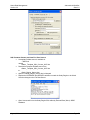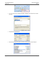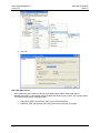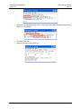
1
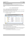
Hazus Data Management
International Workflow For Newland (ND)
August, 2014
Developed By:
Data 3.0 Professional Services
data30.com
Hazus Data Management
Version 2.2
International Workflow
Data 3.0
Table of Contents
Project Overview ........................................................................................................................................... 3
Design Considerations .................................................................................................................................. 4
File Management .......................................................................................................................................... 6
Document Management ................................................................................................................................ 8
Workflow Overview ....................................................................................................................................... 9
Task 1 – Prepare Hazus Databases ........................................................................................................... 11
Task 1.1 - Prepare Hazus Boundaries ................................................................................................... 11
Task 2 – Prepare CBD Data Sources ......................................................................................................... 20
Task 2.1 - Prepare Data Sources ........................................................................................................... 20
Task 2.2 - Prepare Models ..................................................................................................................... 21
Task 2.3 - Install Hazus Databases ........................................................................................................ 22
Task 3 – Building Inventory ......................................................................................................................... 23
Task 3.1 - Prepare Improvements .......................................................................................................... 24
Task 3.2 - Prepare Building Inventory .................................................................................................... 27
Task 4 – Update Hazus Inventory ............................................................................................................... 34
Task 4.1 – Create User Defined Facilities .............................................................................................. 34
Task 4.2 – Create Study Region............................................................................................................. 36
Task 4.3 – Import User Defined facilities ................................................................................................ 36
Task 5 Hazus Flood Analysis .................................................................................................................. 40
Task 5.1 Import Flood Depth Grid .......................................................................................................... 40
Task 5.2 Create Flood Scenario ............................................................................................................. 41
Task 5.3 Run Flood Analysis .................................................................................................................. 43
Task 5.4 Export Results.......................................................................................................................... 44
Appendix 1
Glossary .............................................................................................................................. 47
Appendix 2
Issues and Questions .......................................................................................................... 48
Appendix 3
Hazus Hints ......................................................................................................................... 49
Appendix 4
SQL Server Hints ................................................................................................................ 55
Appendix 5
FME Algorithms For Building Inventory............................................................................... 62
Appendix 6
FME Algorithms User Defined Facilities ............................................................................. 63
August, 2014
Page 2
Hazus Data Management
Version 2.2
International Workflow
Data 3.0
PROJECT OVERVIEW
In recognition of the importance of planning in mitigation activities, the Federal Emergency Management
Agency (FEMA) has created Hazus - a powerful geographic information system (GIS) based disaster
mitigation tool. This tool enables communities of all sizes to estimate damages and losses from
hurricanes, floods and earthquakes to measure the impact of various mitigation practices that might help
to reduce those losses.
Hazus is designed for use in USA. Universities and organizations around the world are investigating the
potential use of Hazus as a regional solution to model natural disasters for local mitigation projects.
Data 3.0 and the National University of Singapore (NUS) participated in a Hazus International Proof of
Concept (HIPOC) in July 2012. The goal was to integrate local data sets into Hazus to estimate losses
resulting from sea level rise in Singapore. ArcGIS and FME tools were used to customize the building
inventories to a Hazus compatible format. The building inventories were classified with the help of the
Comprehensive Data Management System (CDMS) for flood hazard modelling. A flood depth grid
representing a sea level rise of 2.8m was imported into a Hazus study region created for the Central
Region of Singapore.
Several workflows were tested, and a HIPOC methodology was developed and demonstrated at NUS.
HIPOC Version 2.1 was documented, but it is not for general consumption (it is specific to Singapore
using NUS provided data).
The workflow presented in HIPOC Version 2.2 is intended for users who are seeking a ‘generic’ solution.
The project is built for a synthetic country named Newland (‘ND’ - equivalent to a Hazus State) and a subregion named Central Business District (‘CBD’ - equivalent to a Hazus County).
The goals of HIPOC Version 2.2 are loosely defined as:
1. The model must run in Newland. That means, we do not move Newland to USA, run the model,
and then move Newland back while no one is looking.
2. Replace the US data with Newland data without breaking the model. That means, we do not
move US Census Blocks/Tracts to Newland. Instead, we incorporate new Newland
administrative boundaries.
3. No Hazus US counties or states: these tables need to be populated from the administrative
boundaries defined in Item 2.
4. The Study Region is empty. The country, region, tracts and blocks are generated, but the user
must fill them from local data sources (inventory and demographics).
5. The focus is flood. Flooding is one of the most common hazards around the world. Coastal
flooding is associated with a rise in sea level over and above normal tidal action. The flood model
supports the use of local flood boundaries (or depth grids) and Building Inventory that can be
imported to international Study Regions.
HIPOC Version 2.2 is provided for reference purposes – use with caution. D3 is not responsible for the
content of this workflow, the models, or the final loss estimates - there may be errors or omissions.
August, 2014
Page 3
Hazus Data Management
Version 2.2
International Workflow
Data 3.0
DESIGN CONSIDERATIONS
Hazus is intended for US consumption. It comes pre-packaged with US datasets, and can run “out of the
box”. Therefore, limits to this design will be encountered when adopting Hazus models to international
projects:
1. The Hazus program cannot be altered – we do not have access to the core code. International
customization is made to the supporting databases that Hazus uses as inputs to the model.
2. HIPOC Version 2.2 assumes that the user has a good understanding of the Hazus and CDMS
data requirements. Other data management tools are needed to create Hazus compliant data
from local sources. The HIPOC ETL tool of choice is FME (Safe Software).
3. A solid Hazus installation is required. To confirm, create a Study Region in Boone County,
Indiana (without error conditions). See Appendix 3 – Hazus Hints.
Version 2.2 of the HIPOC is focused on creating a Study Region anywhere in the world. The Study
Region is empty, but the structure will support inventory updates using CDMS. There are known design
limitations:
1. ArcGIS Ver 10.0 FME tools no longer support ESRI Ver 8.1 geodatabases. The Hazus GDBs
have been upgraded to 10.0. Hazus seems to support 10.0 GDBs, but further testing may be
needed.
2. All source data must be projected to GSC-NAD83 before starting work. This is the only projection
system that Hazus and CDMS support.
3. One country at a time. The ‘ND’ qualifier for Newland is used to replace the statewide tables for
North Dakota. The Hazus StateFIPs is 38.
4. The HIPOC Ver2.3 inventory is structured for flood projects.
5. Aggregate models do not run (the inventory tables are empty). Therefore, Tract and Block
boundaries are not needed to aggregate the inventory. One Tract and one Block will be created
using the same geometry as the County in order to create the Study Region. Flood models may
be run using imported UDFs.
6. The HIPOC Ver 2.2 workflow extends to creating the Study Region and running a flood analysis
using a pre-defined flood depth grid. Workflows that describe other Hazus flood modeling options
are project specific.
7. The provided World State and County boundaries are low resolution (to save space) and may
need to be updated from higher quality local data sources.
Version 2.3 of the HIPOC has been extended beyond running a UDF flood event in Newland. The
functional model is improved:
1. The HIPOC Ver 2.3 workflow describes updating the Demographics, General Building Stock
(GBS) and Essential Facility (EF) inventories.
2. Multiple countries may be included for a regional solution.
Future versions of the HIPOC can be expanded on future international projects to include:
1.
2.
3.
4.
5.
Other databases (e.g. Vehicles, Utility and Transportation) may be included.
Earthquake hazard models may be integrated.
Hurricane hazard models may be integrated.
Depth damage functions need to be developed outside of US construction types.
Customize the Hazus Study Region GUI by adding/modifying the records in syHazus.mdf
(StateName = ’Singapore’, StateID = ‘SG’, StateFIPs=’99’). This did not work in HIPOC 2.3 –
there are too many dependencies on the StateID in supporting databases.
6. High-rise buildings need special attention. NumStories > 9 are not supported in Hazus.
August, 2014
Page 4
Hazus Data Management
Version 2.2
International Workflow
Data 3.0
7. Multi-use building codes need special attention. Buildings used for RES1 (upstairs) and COM1
(ground floor) are commonplace, and not currently supported.
If Hazus is to be used as a global tool, certain design obstacles need to be overcome. These items
cannot be entertained without support from the Hazus developers:
1. Hazus user guides and technical manuals are in English. There are no descriptions about
customizing the Hazus databases for international users.
2. Hazus is limited to US$ and feet. Euros or Metres are not used anywhere.
4. The Hazus projection system is GCS-NAD83. GCS-NAD83 is not a global projection system.
International implementations will be performed in GCS-WGS84
3. There are tricks to installing Hazus on a non-US device.
4. Technical support is always 12 hours away.
5. Sensitivity/validation studies needed to instill confidence in the modeling results.
8. Allow the user to modify/add State names in syHazus.mdf (e.g. StateName = ’Singapore’, StateID
= ‘SG’ and StateFIPs = ’99’).
9. Provide the ability for user-defined Study Region boundaries.
August, 2014
Page 5
Hazus Data Management
Version 2.2
International Workflow
Data 3.0
FILE MANAGEMENT
BACKUPS
Hazus does not support server-based workflows. Therefore, the HIPOC project is based on work that is
performed on a local drive. User logins are sufficient - Hazus no longer requires administrator passwords.
Work performed on local PCs will need to be periodically secured. References to the Q:\drive in this
workflow refer to the backup server used at D3:
C:\Projects\Hazus_Projects\Hazus_International
Local project drive
Q:\Hazus_International
Backup drive
PROJECT MANAGEMENT
Project documentation is stored under the following directory structure:
C:\Projects\Hazus_Projects\Hazus_International\Project_Management
Status
Project management progress reports
Advisory
Reference materials for HIPOC implementations
Workshops
Meetings and workshop materials
DATA MANAGEMENT
Data sets are managed under the following directory structure:
C:\Projects\Hazus_Projects\Hazus_International\Data_Management
Data_Sources
Pre-processed data
Hazus_Updates
Updated statewide tables
Models
Analysis data and results
DATA SOURCES
Data sources received from various agencies are organized by geography:
…\Data_Management\Hazus_International\Data_Sources
ND
Newland national data
HAZUS_UPDATES
Updated Hazus inventory is organized by country and inventory type. The Hazus_Updates folder is
where the Hazus inventory is replaced from the data in \Data_Sources
…\Data_Management\Hazus_International\Hazus_Updates\ND
User_Defined_Facilities
UDF MDBs for import into Hazus
Tools
FME scripts to create the CDMS import MDBs
Templates
Empty MDB schemas
Statewide
ND Hazus tables
Working
Temporary area for work in progress
MODELS
The \Models folder contains the results of the analysis as well as the hazard and inventory datasets used
as inputs. Modeling is performed in a Hazus Study Region built by country, state or County.
…\Data_Management\Models
ND
Newland model results
Template
Templates and tools used for next HIPOC
…\Data_Management\Models\ND\
Analysis
HPR
MXD_Documents
Reports
August, 2014
Updates to hazard and inventory databases
Exported Hazus Study Regions
Production and final mapping documents
Documents and logs
Page 6
Hazus Data Management
Version 2.2
International Workflow
Data 3.0
ANALYSIS
Subfolders under \Models contain tools, documents and reports used in the development of the model.
…\Data_Management\Models\ND\
Analysis\Flood
Flood hazard updates and loss results
Analysis\Inventory
Building Inventory
Analysis\Tools
Data processing tools
Reports
Output maps, tables, reports and logs
Tools
FME scripts used to create BI GDBs
Working
Temporary area for work in progress
Reports\Workflow
Project workflow document
August, 2014
Page 7
Hazus Data Management
Version 2.2
International Workflow
Data 3.0
DOCUMENT MANAGEMENT
The workflow document is maintained by D3 for use by both teams working on the Pre-Disaster Mitigation
(Hazus) project for HIPOC. The name of the file is:
…\Workflow\ND_CBD_Workflow_v<V>_<R>.docx
where
<V>
Version number 1-9
<R>
Revision number 1-9
The following abbreviations are used throughout the document:
[TBD]
To Be Determined
[PIO]
Process Improvement Opportunity
[Name]
Contributions required by …
[Rev]
Major revision marker
[Note]
Miscellaneous hints to the reader
Versions are incremented with each project milestone.
Version
2.2
August, 2014
Date
12-Aug-2014
Change
Document started
Page 8
Hazus Data Management
Version 2.2
International Workflow
Data 3.0
WORKFLOW OVERVIEW
Generic tasks to update Hazus v2.1 databases to support flood models in Newland are described below.
The user will be able to create Study Regions inside their home countries based upon the workflow and
tools developed for CBD.
WORKFLOW DIAGRAM
TASK 1 PREPARE HAZUS DATABASES
1.
2.
3.
4.
5.
Refresh Boundaries
Add State Boundary for Newland
Add County Boundary for CBD
Add Census Block and Tract Boundaries for CBD
Install Hazus databases for Newland
Outputs:
syBoundary.mdb
ND
bndrygbs.mdb
ND
EF.mdb | UTIL.mdb | TRNS.mdb | HPLF.mdb
TASK 2 PREPARE CBD DATA SOURCES
1. Download source data from Newland FTP site
2. Copy Models\Template folder
3. Prepare template documents
Outputs:
Models\CBD
August, 2014
Page 9
Hazus Data Management
Version 2.2
International Workflow
Data 3.0
TASK 3 BUILDING INVENTORY
1. Create Improvements from local data sources
2. Create Building Inventory from Improvements.
Outputs:
ND_CBD_BI_GDB.mdb
TASK 4 UPDATE HAZUS INVENTORY
1. Create a ‘Hazus ready’ UDF database from CBD Building Inventory
2. Create a Flood Study Region for CBD
3. Import UDFs into CBD Study Region
Outputs:
ND_CBD_Hazus_Import_UDF.mdb
TASK 5 HAZUS FLOOD ANALYSIS
1.
2.
3.
4.
Import Flood Depth Grid
Create Flood Scenario
Run Flood Analysis
Export Results
Outputs:
ND_CBD_FL_Analysis_GDB.mdb
ND_CBD_FL_UDF.hpr
August, 2014
Page 10
Hazus Data Management
Version 2.2
International Workflow
Data 3.0
TASK 1 – PREPARE HAZUS DATABASES
Hazus-2.1 statewide datasets will be updated before the local Study Regions can be made.
Demographics, General Building Stock and Essential Facility databases will be refreshed (all records
deleted) in Task 1. Boundary records for Newland will be imported. Inventory records for CBD will be
imported.
TASK 1.1 - PREPARE HAZUS BOUNDARIES
TASK 1.1.1 – REPLACE HAZUS BOUNDARIES WITH WORLDWIDE BOUNDARIES
Pre-populated Hazus databases that can be used world-wide are provided in \World. International State
and County boundaries have been added, but the inventory is blank.
Blank Hazus databases are provided in \Blank. The desired records from \World are exported to \Blank.
The user must populate the empty Block and Tract records.
•
Copy \Blank\*.mdb to \ND
[Note] For users wanting to create their own World statewide tables, copy the default Hazus statewide
tables for a representative state and delete the records from each database. In this case, users will need
to add their own State and County boundaries.
TASK 1.1.2 – RELATE STATE BOUNDARIES TO COUNTY BOUNDARIES
Not all pre-populated countries (226) and regions (3,203) will be needed. The countries of interest will be
identified, and the associated interior regions will be related. For the IHPOC, the Study Area will be
Singapore (the corresponding State will be Newland – ‘ND’).
•
Open \Models\ND\MXD_Documents\ND_CBD_Hazus_Boundaries.mxd
August, 2014
Page 11
Hazus Data Management
Version 2.2
•
•
International Workflow
Data 3.0
Add the ND_CBD_Hazus_Boundaries.tbx toolkit from \Hazus_Updates\ND\Tools\
Edit the tool named 1_syBoundary_syCounty. Modify the WHERE Clause to the country (or
countries) to be modelled. Set the Destination Geodatabase to the syBoundary.mdb to be
updated. Run the tool.
August, 2014
Page 12
Hazus Data Management
Version 2.2
International Workflow
Data 3.0
•
The tool will copy selected syState and related syCounty records from \World to \ND. In the
case of IHPOC, the Newland State and County boundaries will be exported and following
attributes populated:
syState | StateFips = ‘38’
syState | HUState = ‘0’ (Hurricane model not supported in HIPOC)
syState | NumCounties = ‘nnn’ (the record count in syCounty where State = ‘ND’)
syCounty | CountyFips = StateFips & ‘nnn’
•
Save the FME log file to
…\Hazus_International\Data_Management\Models\ND\Reports\Logs
ND_FME_syBoundary_syCounty_140819.txt
[Note] Removing unwanted countries and regions from syBoundary.mdb is optional. However, the
databases will be more efficient, and the Study Region creation process streamlined if the Hazus tables
are restricted to the Study Area limits.
[Note] Multiple countries can be selected if a regional solution is needed.
[Note] For users wanting to write their own ETL tools, modify syBoundary.mdb to remove all records
outside of the Study Area.
TASK 1.1.3 – RELATE COUNTY BOUNDARIES TO TRACT BOUNDARIES
Tract boundaries are stored in syBoundary. Tract boundaries will be generated from the regional County
boundaries (one Tract per County).
•
•
Open \Models\ND\MXD_Documents\ND_Hazus_Boundaries.mxd
Edit the tool named 2_syBoundary_syTract. Set the Destination Geodatabase to the
syBoundary.mdb to be updated. Run the tool.
August, 2014
Page 13
Hazus Data Management
Version 2.2
•
International Workflow
Data 3.0
The tool will export the regional boundaries to \ND\syBoundary | syTract. The County
boundaries are deaggregated (polygon parts are made into separate Tracts) and the
following attributes populated:
syTract | Tract = ‘38001000001’ through ‘3800n00000x’
syTract | CountyFips = ‘38001’ through ‘3800n’
syTract | Tract6= ‘000001’ through ‘00000x’
syTract | TractArea = Shape_Area * 4,754 (in sq miles)
August, 2014
Page 14
Hazus Data Management
Version 2.2
•
International Workflow
Data 3.0
Save the FME log file to
…\Hazus_International\Data_Management\Models\ND\Reports\Logs
ND_FME_syBoundary_syTract_140819.txt
TASK 1.1.4 – RELATE TRACT TO BLOCK BOUNDARIES
Tract and Block boundaries are stored in bndrgygbs.mdb, and they need to be generated before a Study
Region can be made. Tract and Block boundaries will be defined by the syTract boundaries previously
created in syBoundary (one Block per Tract).
•
•
Open \Models\ND\MXD_Documents\ND_Hazus_Boundaries.mxd
Edit the tool named 3_bndryGBS_hzBlock. Set the Destination Geodatabase to the
bndryGBS.mdb to be updated. Run the tool.
August, 2014
Page 15
Hazus Data Management
Version 2.2
•
International Workflow
Data 3.0
Save the FME log file to
…\Hazus_International\Data_Management\Models\ND\Reports\Logs
ND_FME_bndryGBS_hzBlock_140819.txt
August, 2014
Page 16
Hazus Data Management
Version 2.2
•
International Workflow
Data 3.0
Edit the tool named 4_bndryGBS_hzTract. Set the Destination Geodatabase to the
bndryGBS.mdb to be updated. Run the tool.
August, 2014
Page 17
Hazus Data Management
Version 2.2
•
International Workflow
Data 3.0
Save the FME log file to
…\Hazus_International\Data_Management\Models\ND\Reports\Logs
ND_FME_bndryGBS_hzTract_140819.txt
TASK 1.1.5 – UPDATE MAPPING SCHEMES
Each Block has a corresponding record in MSH.mdb to show the distributions of building types and .
•
•
Open \Models\ND\MXD_Documents\ND_Hazus_Boundaries.mxd
Edit the tool named 5_MSH_SchemeMapping. Set the Destination Geodatabase to the
MSH.mdb to be updated. Run the tool.
August, 2014
Page 18
Hazus Data Management
Version 2.2
•
International Workflow
Data 3.0
Save the FME log file to
…\Hazus_International\Data_Management\Models\ND\Reports\Logs
ND_FME_MSH_SchemeMapping_140819.txt
The \ND statewide tables are now formatted to run with Hazus. They may be used to create a Study
Region, but they will be empty. All tables have been populated with default values, and must be updated
using local data sources. Data population strategies are provided in HPOC Ver 2.3.
The following sections describe how to model a flood event using local Building Inventory.
August, 2014
Page 19
Hazus Data Management
Version 2.2
International Workflow
Data 3.0
TASK 2 – PREPARE CBD DATA SOURCES
The General Building Stock and Essential facility databases were flushed out in Task1. The GBS and EF
records will be updated for CBD using local data sources in Task2.
A modeling folder structure will be setup that contains the source materials, mapping templates, tools,
source data sets and final reports.
TASK 2.1 - PREPARE DATA SOURCES
TASK 2.1.1 –DATA EXCHANGE
Box.net is the preferred HIPOC data portal. Typical data sets to exchange include:
•
•
Inventory sources (Building Footprints)
Hazard sources (depth grids).
The HIPOC data portal can be accessed at the following URL. It is password protected:
https://box.com/hipoc/gh5iwbcdxf5tlejkppw8
TASK 2.1.2 –DATA BACKUPS
The \Tools folder contains scripts that will be used to process the County datasets. A .bat script is
provided to make incremental backups to Q:\drive.
•
•
•
Rename:
From:
ND_County_Backups.bat
To:
ND_CBD_Backups.bat
Open ND_CBD_Backups.bat in Notepad and replace all occurrences:
From:
<Region>
To:
active County name (e.g. “CBD”)
Run the BAT file at significant project milestones to back-up work to the Q:\drive. The script
also creates directory listings of the current files and folders under:
…\Models\CBD\Reports\Logs
August, 2014
Page 20
Hazus Data Management
Version 2.2
International Workflow
Data 3.0
TASK 2.1.3 – DATA SOURCES
Data Source folders have been created as a repository for the raw GIS databases provided by Newland
and other GIS vendors. The data sources are organized by data provider and date. Data source folders
contain the original data – all data processing events occur in the modeling folders.
•
Copy the source data from FTP to
…\Hazus_International\Data_Management\Data_Sources\
<Vendor_Name>\<yymmdd>\
TASK 2.2 - PREPARE MODELS
Model folders are provided to house the local inventory, hazard definitions and analysis results for CBD.
TASK 2.2.1 - MODEL FOLDERS
Model folders have been created for the data processing and modeling activities. The models are derived
from a standard Template. Each template contains the folder structures and tools used to prepare the
source data and model data for each County. The Template contains the knowledge base for the project
– it is updated on the Q:\ drive as processes are improved.
•
•
Copy the source data template from
Q:\ND HIPOC\Data_Management\Data_Sources\Models\Template
to
…\Hazus_International\Data_Management\Data_Sources\Models\CBD
Copy the modeling template from
Q:\ND HIPOC\Data_Management\Models\Models\Template
to
…\Hazus_International\Data_Management\Models\Models\CBD
TASK 2.2.2 - TEMPLATES
Template documents need to be setup for each County. Rename all templates and change the file
properties. Modify the contents to reflect the active model (CBD).
•
•
•
Rename:
From:
ND_County_*.*
To:
ND_CBD_*.*
Update the File Properties on all CBD documents
Subject:
CBD
Author:
<Enter your name here>
Comments:
2014 Pilot
Category:
HIPOC Newland
Company:
D3 | Newland
Open each document in Word and replace all occurrences:
From:
<Region>
To:
The active County name (e.g. “CBD”)
TASK 2.2.3 - WORKING FOLDERS
Working folders and GDBs are provided as temporary data stores to process intermediate feature
classes. Working folders or files are temporary – they may be removed after the Hazus inventory is
updated:
…\Models\CBD\Analysis\Working
ND_CBD_Working_GDB.mdb
August, 2014
Page 21
Hazus Data Management
Version 2.2
International Workflow
Data 3.0
…\Models\CBD\Hazus_Updates\Working
ND_CBD_Working_GDB.mdb
TASK 2.3 - INSTALL HAZUS DATABASES
Any changes made to the Hazus statewide databases during the course of this project will be version
controlled. Details of the changes will be documented:
…\Models\CBD\Reports\Logs\
ND_CBD_Hazus_Updates_<yymm>.doc
ND_CBD_Hazus_Updates_<yymm>.xls
Changes to the Hazus Study Region databases are not version controlled. The most current Hazus
databases must be installed on all local PCs where Hazus modeling will be performed.
TASK 2.3.1 - REPLACE DEFAULT DATABASES
The Hazus default General Building Stock specific database must be replaced with the updated database
provided by Newland before creating the Study Region.
•
•
•
Updated Hazus databases for Newland are provided in:
…\Hazus_Updates\Statewide\ND\
Copy the updated boundary database from:
…\Hazus_Updates\Statewide\ND\syBoundary.mdb
to:
C:\HazusData_21\
syBoundary.mdb
Copy the remaining inventory databases from:
…\Hazus_Updates\Statewide\ND\*.mdb
to:
C:\HazusData_21\ND\
*.mdb
August, 2014
Page 22
Hazus Data Management
Version 2.2
International Workflow
Data 3.0
TASK 3 – BUILDING INVENTORY
Building Inventory is considered to be the most current and accurate database of the structures to be
modeled by Hazus. It is often created by linking the parcel centroids with tax assessor improvement
records. For the HIPOC, Building Inventory is generated from building footprints.
The workflow to create Building Inventory starts with building footprints which is maintained by Newland.
Not all desired fields have been populated (typical), so missing values will be derived or defaulted.
Improvements represent the foundation feature class for the creation of Building Inventory. It is created
by populating values with best available data.
The high-level workflow to create Building Inventory is described below:
Task 3.1 – Prepare Improvements
Run the FME script called Cental_Facilities_2_Improvements
Creates Improvements at the centroid of each building footprint
Joins Permits to Building Points to populate ‘blank’ Hazus fields
Calculates Building Area and NumStories
Calculates Building Cost from Building Area
`
Converts Cali to Hazus Occupancy Code
Project Improvements to GCS_NAD83
Task 3.2 – Migrate Building Inventory
August, 2014
Page 23
Hazus Data Management
Version 2.2
International Workflow
Data 3.0
Run the FME script called Improvements_2_BI
Creates Building Inventory from Improvements
Converts all values to Hazus domains
TASK 3.1 - PREPARE IMPROVEMENTS
[Note] The workflow to create Improvements will vary from country to country, and cannot be
standardized. The source databases to be used for Improvements need to be prepared for each Study
Region. Skeleton tasks are provided for reference purposes only.
Improvements is a point feature class that represents the structures within CBD to be modeled.
Improvements are unique to Newland, and represent the merging of the best available sources into a
common feature class. The goal of Task 3.1 is to extract as much information as possible for each
building record. Attributes will be populated where they exist. Attributes will be derived or defaulted
where they do not exit.
The Task 3.1 schema/tools/workflow is customized for each project. The Improvements
schema/tools/workflow must also be customized for each region if the source data structure (or content) is
not consistent within all Newland Regions.
Improvements are used to create Building Inventory. Building Inventory is “generic” – it is a defined
schema that has been designed to work with Hazus and other modeling tools across all projects.
TASK 3.1.1 - DOWNLOAD DATA SOURCES
Building Footprints have been posted to the HIPOC FTP site. Download the Newland GDB to the local
\Data_Sources folder:
•
Download Footprints to:
…\Data_Sources\Newland\Inventory\
NL_Region1_Buildings_GDB.mdb
TASK 3.1.2 – CLIP FOOTPRINTS TO CBD BOUNDARY
Region1 building footprints (polygons) must be clipped to the CBD boundary and converted to points
(centroids). A working folder and GDB has been setup to prepare the source data.
•
•
•
Open the MXD named:
…\Models\CBD\MXD_Documents
ND_CBD_BI_Updates.mxd
ArcToolbox | Analysis Tools | Extract | Clip to export Region1_Buildings within the CBD
boundary to the Working GDB. Send the output to:
…\Models\CBD\Analysis\Working
ND_CBD_Working_GDB.mdb
ND_CBD_Working_GDB.mdb | CBD_Footprints
ArcToolbox | Data Management Tools | Features | Feature To Point to export
CBD_Footprints to the Working GDB. Send the output to:
…\Models\CBD\Analysis\Working
ND_CBD_Working_GDB.mdb
ND_CBD_Working_GDB.mdb | CBD_Buildings
TASK 3.1.3 – CONVERT BUILDINGS TO IMPROVEMENTS
August, 2014
Page 24
Hazus Data Management
Version 2.2
International Workflow
Data 3.0
CBD_Buildings will be combined to a common Improvements feature class. Missing values will be
populated. Populated values will be migrated – unpopulated values will be defaulted or derived from
other values. The scripts are setup for CBD, but may be modified for other Regions.
•
•
•
•
Add the HIPOC CBD FME BI toolbox to ArcTools from:
…\Models\CBD\Tools\ND_CBD_FME_BI.tbx
Right-click | Edit the 2_Buildings_2_Improvements tool to open up the FME workbench.
Set the input Published Parameters | Source to:
…\Models\CBD\Analysis\Working\
ND_CBD_Working_GDB.mdb
Set the output Published Parameters | Destination to:
…\Models\CBD\Analysis\Inventory\Improvements\
ND_CBD_Improvements_GDB.mdb
August, 2014
Page 25
Hazus Data Management
Version 2.2
•
•
•
•
International Workflow
Data 3.0
Run the script and review the log file to make sure that CBD_Buildings records were
processed correctly.
Add CBD Improvements to the MXD and review the results.
If all OK, save the log file to
…\Models\CBD\Reports\Logs\
ND_CBD_FME_Buildings_To_Improvements_<yymmdd>.txt
Exit the FME workbench and save the changes to the ND_CBD_Buildings_To_Improvements
tool.
The algorithms used in the Buildings_2_Improvements FME script are provided in Appendix 3. In
general:
•
•
•
•
•
•
•
•
•
•
Filter out unwanted records (Vacant and Abandoned)
Filter our “non-structures” (e.g. Swimming pools, patios, sheds, parking lots etc…)
Convert Area to sq feet and Cost to US dollars
Calculate NumStories = Height * 3.28 / 10
Calculate BldgArea = Area * NumStories
Calculate FirstFloorHt = Elev * 3.28
Normalize Occupancy Codes based upon FType
Refine RES occupancies from numbers of occupants
Calculate YearBuilt = AssessmentYear – Age
Derive missing YearBuilt values from nearest neighbor.
August, 2014
Page 26
Hazus Data Management
Version 2.2
International Workflow
Data 3.0
TASK 3.2 - MIGRATE BUILDING INVENTORY
The Improvements generated from CBD_Buildings will be used to create Building Inventory.
Building Inventory becomes the foundational feature class for updating the Hazus General Building Stock
(aggregated data) and Hazus User Defined Facilities (individual points). Where Improvements are unique
to Newland (content and structure), Building Inventory is generic (consistent content and structure
between projects).
August, 2014
Page 27
Hazus Data Management
Version 2.2
International Workflow
Data 3.0
Field mappings and data loading algorithms built into the Improvements tools are provided in Appendix 3.
TASK 3.2.1 - CREATE BUILDING INVENTORY FROM IMPROVEMENTS
Tools have been written to convert CBD Improvements into Building Inventory.
•
•
Add the Newland CBD FME BI toolbox to ArcTools from:
…\Models\CBD\Tools\ND_CBD_FME_BI.tbx
Right-click | Edit the Improvements_To_BI tool to open up the FME workbench.
August, 2014
Page 28
Hazus Data Management
Version 2.2
•
•
•
•
•
•
International Workflow
Data 3.0
Set the input Published Parameters | Source to:
…\Models\CBD\Analysis\Inventory\Improvements\
ND_CBD_Improvements_GDB.mdb
Set the output Published Parameters | Destination to:
…\Models\CBD\Analysis\Inventory\Building_Inventory\
ND_CBD_BI_GDB.mdb
Run the script and review the log file to make sure that CBD_Buildings records were
processed correctly.
Add CBD Improvements to the MXD and review the results.
If all OK, save the log file to
…\Models\CBD\Reports\Logs\
ND_CBD_FME_Improvements_To_BI_<yymmdd>.txt
Exit the FME workbench and save the changes to the ND_CBD_Improvements_To_BI tool.
August, 2014
Page 29
Hazus Data Management
Version 2.2
International Workflow
Data 3.0
TASK 3.2.2 – BUILDING INVENTORY REPORTS
•
•
Add Data for datasets
…\Data_Management\Models\CBD\Analysis\Bldg_Inventory\BI\
IN_CBD_BI_GDB.mdb | BI
…\Data_Management\Models\CBD\Analysis\Flood\Hazus
IN_CBD_FL_Analysis_GDB.mdb
DFirm_100
ArcTools | Analysis Tools | Overlay| Clip to determine the flood prone buildings. Save the output
feature to:
…\Data_Management\Models\CBD\Analysis\Inventory\BI
IN_CBD_BI_GDB.mdb
BI_FP_100
August, 2014
Page 30
Hazus Data Management
Version 2.2
•
International Workflow
Data 3.0
Close ArcMap
Access scripts have been written to report the structures by general occupancy. Reports may be created
for all BI within CBD, or just the BI within the flood boundary.
•
•
Open the Building Inventory database in Access
…\Models\CBD\Analysis\Inventory\Building_Inventory\
IN_CBD_BI_GDB.mdb
Right-Click | Run the macro named BI_Reports_Maker
August, 2014
Page 31
Hazus Data Management
Version 2.2
•
Export the report named BI_By_Occupancy to:
…\CBD\Hazus_Updates\Tables\
ND_CBD_BI_By_Occupancy.pdf
•
Export the report named BI_FP_100_Occupancy to:
…\CBD\Hazus_Updates\Tables\
ND_CBD_BI_FP_100_By_Occupancy.pdf
August, 2014
International Workflow
Data 3.0
Page 32
Hazus Data Management
Version 2.2
August, 2014
International Workflow
Data 3.0
Page 33
Hazus Data Management
Version 2.2
International Workflow
Data 3.0
TASK 4 – UPDATE HAZUS INVENTORY
Hazus-2.1 comes bundled with default modeling data. The Hazus default data is segregated into
geodatabase tables for each State. The Statewide data is the master from which Hazus Study Regions
are extracted. Hazus performs natural disaster analysis against the Study Region.
Tools and workflows were developed to update Hazus databases for the HIPOC. The tools and
workflows may be applied to Regions outside of CBD, but they will need to be customized to the local
data sources.
Task 4 provides the steps needed to import Building Inventory into Hazus as User Defined Facilities. This
inventory is generally used for point based (detail) flood loss analysis.
Task 4 – Import User Defined Facilities
Use the FME script called BI_To_UDF to create User Defined Facilities
Create a Hazus Flood Study Region
Import UDFs into the Hazus Study Region and test the results
TASK 4.1 – CREATE USER DEFINED FACILITIES
The Building Inventory will be imported into the Hazus Study Region as User Defined Facilities for point
analysis of detailed geographic areas. Each UDF point represents a BI point at risk to earthquake, flood
or wind losses.
User Defined Facilities are not supported in CDMS. User Defined Facilities will be imported into the
Study Region using Hazus. The UDFs must be re-imported to each Study Region to analyze losses to
individual structures (typically flood models or other small/detailed geographies).
Buildings with potential losses from flood hazards will be translated to User Defined Facilities. BI is a
feature class, from which Access UDF tables formatted for Hazus flood modeling will be created. Only
UDFs within the flood boundary will be imported (Task 3).
[Note] The steps to import the User Defined Facilities into a Study Region using Hazus Import tools are
documented in the Hazus Flood User Manual.
[Note] The tools also support earthquake models. To import UDFs into an earthquake model, use the
existing workflow and change the hazard type from Flood to Earthquake.
TASK 4.1.1 - CREATE UDFS FROM BUILDING INVENTORY
A FME script named BI_2_UDF migrates Building Inventory to UDFs. Building Inventory is re-processed
to fit the Hazus database structure and domains. The script is setup for CBD, but may be modified for
other Regions.
•
•
•
Open ND_CBD_Hazus_Updates.mxd
If needed, add the HIPOC Newland FME toolbox to ArcTools from:
…\Models\CBD\Tools\ND_CBD_FME_Hazus_Updates.tbx
Right-Click | Edit the BI To UDF tool
August, 2014
Page 34
Hazus Data Management
Version 2.2
•
•
•
•
International Workflow
Data 3.0
Set the input Parameters Source to:
…\Models\CBD\Analysis\Inventory\Building_Inventory\
ND_CBD_BI_GDB.mdb | BI_FP_100
Set the output Parameters Sources to:
…\Models\CBD\Hazus_Updates\User_Defined_Facilities\
ND_CBD_Hazus_Import_UDF.mdb
Run the script and review the log file to make sure all records were processed. All
BI_FP_100 records should be migrated as UDFs.
Save the log file to
…\Models\CBD\Reports\Logs\
ND_CBD_BI_To_UDF_FL_<yymmdd>.txt
August, 2014
Page 35
Hazus Data Management
Version 2.2
•
International Workflow
Data 3.0
Save the changes to the FME script and exit ArcGIS.
The populated Access UDF tables can now be imported into Hazus.
The algorithms used in the BI_2_UDF FME script are provided in Appendix 5.
TASK 4.2 – CREATE STUDY REGION
TASK 4.2.1 - CREATE A STUDY REGION
A Study Region must exist before User Defined Facilities can be imported. Steps to create a Study
Region and perform flood modeling are documented in the CBD Risk Assessment Workflow.
•
•
Open Hazus
Create a Flood Study Region for CBD, Newland.
Name:
ND_CBD_FL_UDF
Description:
HIPOC Flood analysis using updated GBS and UDF
TASK 4.3 – IMPORT USER DEFINED FACILITIES
TASK 4.3.1 IMPORT UDFS TO HAZUS
[Note] Steps to import UDFs into Hazus are documented in more detail in the Hazus Flood User Manual.
•
•
•
•
Open Hazus
Open the Flood Study Region
ND_CBD_FL_UDF
Inventory | User Defined Facilities
Right-click in the open area of the User Defined Facilities window and select Import
August, 2014
Page 36
Hazus Data Management
Version 2.2
•
•
•
International Workflow
Data 3.0
Select the CBD UDF database
…\Data_Management\Models\CBD\Hazus_Updates\User_Defined_Facilities\
ND_CBD_Hazus_Import_UDF.mdb
Select the table UDF_FL from the Table List and click OK
In the Mapping window select the Load button and navigate to:
…\Data_Management\Models\CBD\Hazus_Updates\Tools\
UDF_FL.sav
August, 2014
Page 37
Hazus Data Management
Version 2.2
•
International Workflow
Data 3.0
Choose OK to finish importing User Defined Facilities into the Study Region inventory.
TASK 4.3.2 - REVIEW UDFS IN HAZUS
Review the UDFs in Hazus before proceeding:
•
•
Inventory | User Defined Facilities
Click on Map to display the UDFs
August, 2014
Page 38
Hazus Data Management
Version 2.2
International Workflow
Data 3.0
Make sure that the UDFs are correctly loaded into the Study Region.
•
•
•
•
•
The UDF count should match the flood prone BI count.
UDFs should not be outside the County/study region boundaries.
The UDF locations should be the same as the BI locations.
The attributes populated in:
…\Models\CBD\Hazus_Updates\User_Defined_Facilities\
ND_CBD_Hazus_Import_UDF.mdb
UDF_FL_100
should be viewable in Hazus | Inventory | User Defined Facilities
Foundation Type values should be numbers (4,5 and 7 are the most common values), not
letters (B, C and S).
August, 2014
Page 39
Hazus Data Management
Version 2.2
TASK 5
International Workflow
Data 3.0
HAZUS FLOOD ANALYSIS
Losses are reported from the User Defined Facilities that have been generated from the Building
Inventory. Hazus provides several options for performing flood analysis based upon the available source
materials. The HIPOC process to perform flood analysis requires a pre-defined flood depth grid (Option
4).
Option
1
Analysis
H&H SRP
2
H&H FIS
3
EQL
4
FDG
Conditions for Use
Hazus generates flood boundaries and flood depth
grid from the DEM. Single return periods (usually
100-year) are used.
Hazus generates flood boundaries and flood depth
grid from the DEM. Return periods are enhanced
using FIS discharge values.
Hazus generates the flood depth grid from the
DEM and provided flood boundary.
Hazus models the losses from a user-defined flood
depth grid that has been generated from another
modeling application (such as HecRas).
[Note] Option 4 is documented. Consult the Hazus Flood User’s Manual for Options 1-3 using alternative
data sources.
TASK 5.1 IMPORT FLOOD DEPTH GRID
Option 4 is the preferred option when third-party flood depth grids are available.
1.
2.
3.
4.
5.
Hazard | User Data | Depth Grid to import the FDG
Hazard | Scenario | New
Hazard | Riverine | Delineate Floodplain
Analysis | Run
Results | User Defined facilities
TASK 5.1.1 – PREPARE FLOOD DEPTH GRID
The flood depth grid to be used is specified in the User Data area. A relationship is built between the
flood depth grid and the flood scenario.
•
•
•
•
Hazard | User Data
Select the Depth Grid tab
Use the Browse button and navigate to:
…\Data_Management\Data_Sources\Newland\Hazards\
cbd_2_8m
Set the Parameters for Flood Depth grid
Units to “Meters”
Return Period to “100”
August, 2014
Page 40
Hazus Data Management
Version 2.2
International Workflow
Data 3.0
TASK 5.2 CREATE FLOOD SCENARIO
TASK 5.2.1 – CREATE SCENARIO
•
•
•
Go to User Data to add the flood depth grid:
C:\HazusRegions_MR4\<Study Region>\Quick\quickdepth
Set Parameters:
Units
= “Feet”
Return Period (Optional)
=”100”
Hazard | Scenario | New. Name the new Scenario based upon the method used to set up the
model.
<Inventory>_<Period>_<ID>
where
<Inventory> = “GBS”
Aggregate General Building Stock
“UDF”
User Defined Facilities
August, 2014
Page 41
Hazus Data Management
Version 2.2
<Period>
<ID>
•
International Workflow
Data 3.0
“SRP100”
“28m”
“1”
100yr single return period
2.8 meter surge
Unique Study Case Number (1-9)
Select the Flood Depth Grid
In the New Scenario window use the “Add to Selection” button to drag a box around the
desired flood depth grid.
Save the Selection and click OK to complete the Scenario set up.
August, 2014
Page 42
Hazus Data Management
Version 2.2
•
International Workflow
Data 3.0
Hazard | Riverine | Delineate Floodplain
Set the Analysis type to “Single Return Period”
The Period to Analyze should state “100”
Click OK
TASK 5.3 RUN FLOOD ANALYSIS
TASK 5.3.1
•
•
RUN ANALYSIS
Analysis | Run
Select User Defined Facilities in the Analysis Options Window
August, 2014
Page 43
Hazus Data Management
Version 2.2
International Workflow
Data 3.0
TASK 5.4 EXPORT RESULTS
TASK 5.4.1
EXPORT MAPS
UDF analysis results are unavailable in the Hazus Global Summary Report. Instead, UDF losses are
exported to a GDB and reported outside of Hazus.
•
•
•
•
•
•
•
Hazard | Study Case | Open
UDF_28m_1
Export the flood boundaries to:
...\Models\ND\Analysis\Flood\Data\
ND_CBD_FL_Analysis_GDB.mdb
FL_Bndry_100
Results | User Defined Facility
Select the BldgLossUSD column and click Map
Right-click the UserDefinedFlty feature class and Export to
...\Models\ND\Analysis\Flood\Data\
ND_CBD_FL_Analysis_GDB.mdb
UDF_Losses_100
Export the Hazus map as a PDF:
...\Models\ND\Analysis\Flood\Maps\
ND_CBD_UDF_Losses_100.pdf
Exit Hazus
August, 2014
Page 44
Hazus Data Management
Version 2.2
TASK 5.4.2
International Workflow
Data 3.0
EXPORT TABLES
The UDF loss reports will be created in Access
•
•
Open Access to:
...\Models\ND\Analysis\Flood\Data\
ND_CBD_FL_Analysis_GDB.mdb
Run the macro named Losses_Reports_Maker
•
Run the macro named Losses_Reports_Maker
August, 2014
Page 45
Hazus Data Management
Version 2.2
•
International Workflow
Data 3.0
Export the UDF_Losses_GenOcc_100 report as a PDF:
...\Models\ND\Analysis\Flood\Tables\
ND_CBD_UDF_Losses_GenOcc_100.pdf
TASK 5.4.3
BACKUP STUDY REGION
Backup the Study Region into a compressed HPR.
•
•
Open Hazus GUI
Export Region to
...\Models\ND\HPR\
ND_CBD_FL_UDF.hpr
August, 2014
Page 46
Hazus Data Management
Version 2.2
International Workflow
Data 3.0
Appendix 1 Glossary
The following terms and abbreviations are used throughout the workflow documentation.
Abbreviation
CDMS
D3
EF
GBS
HIPOC
UDF
BI
FI
DEM
Building Inventory
Essential Facilities
Facility Inventory
General Building Stock
Study Region
Study Area
User Defined Facilities
CBD
Newland
August, 2014
Context
Abbreviation
Abbreviation
Abbreviation
Abbreviation
Abbreviation
Abbreviation
Feature Class
Feature Class
Raster
Term
Term
Term
Term
Term
Term
Term
Term
Term
Definition
Comprehensive Data Management System
Data 3.0 Professional Services
Essential Facilities
General Building Stock
Hazus International Proof of Concept
User Defined Facilities
Building Inventory
Facility Inventory
Digital Elevation Model 10m statewide
Editing point GDB for Hazus GBS or UDF analysis
Hazus Care, Fire, EOC, Police, School facilities
Editing point GDB for Hazus EF or CF analysis
Hazus aggregate inventory by Tract or Block
Hazus modeling extent (a state)
Hazus area extent (a country)
Hazus point inventory
Dummy Study Region (subset of Newland)
Dummy country (equivalent to a Hazus state)
Page 47
Hazus Data Management
Version 2.2
International Workflow
Data 3.0
Appendix 2 Issues and Questions
Modeling issues were discovered during HIPOC Ver 2.2. Some have been fixed, but others need
consideration before proceeding to the next country.
HAZARDS
•
Flood boundaries and/or depth grids may not be available for other counties.
ENVIRONMENT
•
•
Do we need to consider SQL Server Management Studio? Scripts are provided to compress
the Study Regions without needing SQL Server.
Hazus 2.1 SP3 (released on 20-Feb-2012) was used to develop the HIPOC Ver 2.2 workflow.
The tools may need to be re-run on the current release.
WORKFLOW
•
•
•
Sometimes we “inherit” attributes from surrounding BI (e.g. Year Built). This was not done in
HIPOC.
SQL Server Management Studio is a better option for reporting. Currently the workflow is
based upon Access ODBC connections to SQL Server, which assumes that SQL Server
Management Studio is unavailable.
The xFactors ($/sqft) are derived from Newland. We need to determine new xFactors for
each country. The Newland xFactors were based upon market value, not replacement cost.
REPORTING
•
Hazus UDF reporting options are weak. HIPOC Ver 2.3 will explore GBS inventory to
unleash better reporting tools (debris, shelter, business interruption losses etc…)
•
•
Compress the Study Regions – the SQL log files are huge.
HIPOC Ver 2.3 will explore the idea of syHazus.mdb changes to use the existing country
abbreviations (e.g. ‘SG’ for Singapore) rather than existing state abbreviations (e.g. ‘ND’ for
North Dakota).
HAZUS
August, 2014
Page 48
Hazus Data Management
Version 2.2
International Workflow
Data 3.0
Appendix 3 Hazus Hints
INSTALLATION
Installing Hazus software in the US is a tricky proposition. Preparing a working Hazus environment on a
non-US machine will take some effort.
Here are some generic things to be mindful of:
•
•
•
•
•
•
•
•
You MUST have full admin privileges to install Hazus and its service packs. This is the most
common problem.
The PC must be configured for Hazus 2.1. This means, same operating system (no upgrades,
service packs) and same version of ArcGIS (no upgrades, service packs).
Hazus SP1, SP2 and SP3 may support newer upgrades, but check the install notes just to be
sure.
Make sure all ArcGIS extensions have Hazus-certified service packs. In particular, Data
Interoperability Extension must be FME 2010 SP2.
Hazus installation is a ‘one-time’ shot. In other words, if SP2 does not install properly (say
because someone before you hit “Yes” and did not have the required permissions), then your
install is toast. There is no “uninstall SP2” option. You cannot back out. Hazus must be
uninstalled, re-installed, and then SP1, SP2 etc….
Run Hazus service packs in sequence (i.e. assume that SP2 requires SP1). Hazus is not
consistent about this – sometimes service packs include previous packs, other times not. Do not
take the chance of missing a service pack (i.e. SP3 installed, but not SP1).
The CDMS error “Microsoft Jet OLEDB 4.0 provider is not registered” is not related to Hazus SP1
or SP2.
The solution for most Hazus users is a dedicated Hazus PC. Once setup and working, they are
never touched. PCs are upgraded between projects (never during a project).
If you can’t have a dedicated Hazus PC, then you can setup a dual-boot virtual drive – one for
Hazus, and another for everyone else. Boot to VHD (Virtual Hard Drive) is provided with
Microsoft Windows. It allows a PC to be partitioned into multiple configurations. The Hazus
configuration is a user-selectable option at start-up.
And there are added complications on international PCs:
•
You may be able to fix Study Regions that crash.
August, 2014
Page 49
Hazus Data Management
Version 2.2
International Workflow
Data 3.0
Review the log files first (DTSLOG, FLDTSLOG, AGGREGATIONLOG) in the Study
Region folder. If all OK, then check the syHazus.mdf | dbo.syStudyRegion and change
•
Do not try to install Hazus on a non US-English version of windows. Short of re-installing
Windows (with the US-English code), there are no easy solutions. Errors may come from SQL
Server which insists on consistency between the collation sequence used to create the databases
(which is US English) and collation sequence of the target OS. [PIO] If we pass the correct
collation type (see below) during Hazus install time (when SQL Express is being installed), we
may end up with an international version of Hazus. Alternatively, we have a separate SQL Server
install (after Hazus has been installed).
•
Changing Regional and Language options (highlighted in yellow) may salvage re-installing
Windows and Hazus. It's not ideal to force non-US computers to use US keyboard, character set,
etc…, but it may work.
August, 2014
Page 50
Hazus Data Management
Version 2.2
International Workflow
Data 3.0
ENVIRONMENT
•
•
•
•
Compress the Study Region log files frequently. Keep them below 1GB.
SQL compress scripts have been re-written for SQL 2008/Win7.
Backup Study Regions frequently. The Hazus processes take too long to risk losing the results.
Recommend that
Duplicate the active Study Region daily.
Use the convention <Study Region Name>_Verxx
Work in the most recent Study Region.
Delete Study Regions more than three versions old.
SQL Server Management Studio is a must.
Used to re-establish SQL Server instances. Use Restore Database.
Used to compress the SQL logs which grow very large. Use Compress Log.
Used to manage the UDF imports.
The Hazus process to copy a Study Region corrupted the master Study Region. Not
recommended.
[PIO] SQL Server Management Studio is a better option for reporting. Currently the
workflow is based upon Access ODBC connections to SQL Server, which assumes that
SQL Server manager is unavailable.
Hazus fixit tools are a must:
FixSR runs to re-establish lost Scenarios – this is a lifesaver
[TBD] FixSRBP does not work in Windows 7 – the Study Region Names do not appear.
FLOOD MODELING
•
•
•
The DFirm hurricane boundary contains many records (as many as a few thousand). Run
Dissolve to merge the 100-year polygons into as few as possible. Retain all donuts. The fewer
the polygons, the faster the Hazus processing.
The ESRI Dissolve routine requires at least 2GB RAM to dissolve the 1000+ polygons within a
DFIRM to a single polygon. The Dissolve routine reports the problem, but the only solution is
more memory.
Flood depth grid names are limited to 13 characters. The folder structure cannot be deep – move
FDGs to \Temp before importing them into Hazus.
August, 2014
Page 51
Hazus Data Management
Version 2.2
International Workflow
Data 3.0
UDF FAQS
The limitations of using aggregate data to model flood losses are known. Increasingly, UDFs are being
used to model individual sites. The buildings most at risk are clipped to the flood boundary and imported
into Hazus to determine losses. Alternatively, UDFs may be used to model the following feature classes
that are not currently supported in Hazus:
State-owned buildings
University campus buildings
Flood prone buildings (all occupancy classes)
The following questions have been submitted to the Hazus Help Desk to plan for future Hazus releases:
•
•
•
•
•
UDF reporting is weak. Results are not included in the Global Summary Report.
It is not possible to generate annualized losses from UDFs.
The UDF damage curves can be customized in Hazus 2.1 SP3, but the process is not
documented
BldgDamageFnID
ContDamageFnID
InvDamageFnID
The following fields are not used in the data model:
Foundation Type (except '4'- Basement)
Building Type
Design Level
Condition
Area
If the units for UDF.Cost and UDF.ContentCost are in $1 x 1,000, then the reported losses will be
in $1 x 1,000. If the units for UDF.Cost and UDF.ContentCost are in $1s, then the reported
losses will be in $1s. The Hazus UDF Losses dialog window has "in thou. dollars" in the title bar,
but the exported table headers show USD (so you lose either way).
The general guidelines are:
If BldgCost, ContCost and BldgArea values are imported in $1x1,000 then the losses will
be reported in $1x1,000
If BldgCost, ContCost and BldgArea values are imported in $1s then the losses will be
reported in $1s
If it is important that the GBS "match" the UDFs, then import the UDFs in $1 x 1,000. For
detailed analysis of buildings, it may be better to leave the units as $1s.
•
•
•
Values of "0", "" or <Null> do not work, even though they may exist in Hazus. Make sure that the
following fields are populated correctly:
YearBuilt = "1970" (default if "0" or <Null>)
BldgType = "Wood" (default if <Null>)
UDFs higher than 8 stories will not pass Flood analysis (they will not run at all, with or without
damage functions). This will need to be fixed in Hazus. Can be patched by setting all stories GT
8 to 8. [PIO] Sample inventory up to 3.5m (highest flood risk), and develop damage curves
around the statistical sample. There will be two damage curves per specific occupancy - one low
range, one high range. Run the model twice to determine the range of risk. In this case, set
NumStories to ‘1’ since only the first floor (and below) is of interest.
Basement square footage is not included in Building Area. Hazus uses total finished area (sqft),
so if NumStories = 3 and Area =6,000 then 2,000 per floor. Sometimes we determine Area from
building footprint geometry and building height, where Area = building footprint * height / 10
(assumes 10’ per floor). Basements are captured in the according to Foundation Type. There is
a way to tell Hazus the size of the basement. Very often we have partial basements (i.e. half
crawl, half basement), but I still treat these as Basement = ‘Y’. If basement areas are provided,
use them to set Foundation Type to ‘Basement’.
August, 2014
Page 52
Hazus Data Management
Version 2.2
•
International Workflow
Data 3.0
Unless the user defines specific damage functions, the User Defined analysis uses the GBS
damage functions according to Specific Occupancy. From the Flood User Manual:
“The Flood Model will use the damage functions from the General Building Stock
damage library. The damage functions are associated by the Occupancy code and
key fields, such as “Num of Stories” and “Foundation.” For example, RES1 with
2 stories and a basement would be listed under R12B and a COM1 that is mid rise
and has no basement would be listed under C1MN.”
UDF IMPORTS
•
•
•
•
•
•
•
•
•
•
Before importing the UDFs:
Copy <Study Region>\UDS.mdb to UDS-Copy.mdb (to backup the spatial GDB)
Do NOT map UDFs while attempting to import.
Do not cancel the Import – this is a one-time shot. Re-starting the import tools will result in
duplicate records.
Only one UDF import session is allowed during a Hazus session. The following error message
appears if you attempt to import twice. The Hazus application has locked up - Task Manager out
and re-start Hazus.
After the import, close the User Defined Facilities attribute menu to save changes. Re-open the
menu and map the results to review the imported records.
You can only delete UDFs one page at a time. This can be slow if many records need to be
deleted. Use SQL Server Management Studio (Appendix 2) to delete UDFs for loads that did not
work.
DELETE FROM dbo_hzUserDefinedFlty
DELETE FROM dbo_flUserDefinedFlty
Copy <Study Region>\UDS-Copy.mdb to UDS.mdb (to flush out the spatial records)
If you do not provide the fl values during the import, the key records are created, but all the
values are <Null>.
Try to add a UDF record manually if the imports continue to fail.
There are no "required" attributes except for Latitude and Longitude if loading from a table.
Attempts to import directly from an ArcGIS personal GDB fail with the following error screen:
August, 2014
Page 53
Hazus Data Management
Version 2.2
International Workflow
Data 3.0
•
Spatial accuracy improves when loading from a table with Lat | Lon rather than loading from a
GDB. However, the spatial locations of records imported from a table to not exactly line up with
the original GDB points. The UDF point locations are within +/- 5 meters of the source.
•
Validation feedback is poor – there is no reporting of the data elements that cause the imports to
fail.
August, 2014
Page 54
Hazus Data Management
Version 2.2
International Workflow
Data 3.0
Appendix 4 SQL Server Hints
The Study Region graphic tables are stored in an Access geodatabase and linked to attribute SQL Server
tables. The Geodatabase can be maintained in ArcGIS and the SQL Server tables can be maintained
using Access.
SQL DATABASE CONNECTION USING ACCESS 2003
The location of the Hazus Study Region is always on the local machine. Use REGEDIT to determine
the file paths:
FEMA
Hazus
GENERAL
uid = “Hazuspuser
pwd = “goHazusplus_01
server_name = “in-polis-17\Hazusplussrvr”
•
•
•
•
Open Access to a new database
New Project Using Existing Data
Use a standard convention for a Connection Name:
<State>_Newland_SR.adp
Create
1. Server Name = “in-polis-17\Hazusplussrvr”
2. Use Specific Server Name and Password:
User Name = “Hazuspuser”
Password = “goHazusplus!!!
3. Allow Password Saving
4. Select database
Connect either to the Study Region MDF
5. Test Connection
6. Save Password
SQL DATABASE CONNECTION USING ACCESS 2007
•
•
•
•
•
•
•
•
•
Open Access to a new database
External Data | More | ODBC Database
Link to the data source by creating a linked table
Select Data Source
File Data Source
New
Create A New Data Source
Driver
SQL Native Client
Name File Data Source
<State>_Newland_SR
SQL Server Authentication
User Name = “Hazuspuser”
Password = “goHazusplus_01
Change to default database to the Study Region of interest:
<State>_Newland_<Model>.mdf
Rename the linked Access database saved as:
My Documents/DatabaseX.accdb
to:
<State>_Newland_SR.accdb
SQL DATABASE CONNECTION USING ARCCATALOG
August, 2014
Page 55
Hazus Data Management
Version 2.2
•
•
•
Open ArcCatalog
Database Connections
Add OLE DB Connection
•
Select OLE DB Provider for SQL Server
•
Set Data Link Properties:
August, 2014
International Workflow
Data 3.0
Page 56
Hazus Data Management
Version 2.2
International Workflow
Data 3.0
SQL DATABASE CONNECTION USING FILE DATA SOURCE
•
•
•
•
•
A template file data source is available in:
…\ND\Tools
named
<State>_Template_SQL_Connect_2007.dsn
Rename the template file data source from:
<State>_Template_SQL_Connect_2007.dsn
to:
<Study_Region_Name>.dsn
Open the <Study_Region_Name>.dsn in Notepad
Replace the DATABASE and SERVER variables to match the Study Region to be linked.
Save the changes to the File Data Source.
Open Access and link to the Study Region SQL tables by External Data | More | ODBC
Database.
August, 2014
Page 57
Hazus Data Management
Version 2.2
International Workflow
Data 3.0
•
Link to the data source by creating a linked table. Navigate to the File Data Source created
previously:
•
The password is "goHazusplus!!!"
•
Select the Study Region SQL tables to be linked. Check the option to Save Password.
August, 2014
Page 58
Hazus Data Management
Version 2.2
International Workflow
Data 3.0
SQL USING SQL SERVER MANAGEMENT STUDIO
SQL Server Management Studio is the preferred environment for managing multiple Hazus PCs.
• Open SQL Server Management Studio
• Connect to a Server (usually the local PC) using SQL Server Authentication
•
Right-click Databases and Attach the Study Region databases residing on the Server (usually
the local PC).
•
•
Right-click the SQL database that needs to be compressed.
Select Tasks | Shrink | Database
August, 2014
Page 59
Hazus Data Management
Version 2.2
•
International Workflow
Data 3.0
Click OK
SQL USING SQL SCRIPTS
SQL scripts have been written to manage Hazus Study Region MDFs without SQL Server
Management Studio. The following scripts compress the Study Region log files. It is a good practice
to run these scripts before creating an HND:
•
•
Copy Shrink_MDF.bat and Shrink_MDF.sql to c:\SQLCommands.
Edit Shrink_MDF.bat and enter the correct server name under the –S qualifier.
August, 2014
Page 60
Hazus Data Management
Version 2.2
International Workflow
Data 3.0
•
Edit Shrink_MDB.sql and enter the name of the Study Region MDF database and log file that
need to be compressed.
•
•
Run Shrink_MDF.bat
Review the results in Shrink_MDF.rpt
August, 2014
Page 61
Hazus Data Management
Version 2.2
International Workflow
Data 3.0
Appendix 5 FME Algorithms For Building Inventory
The following filters and mapping schemes were applied to create Building Inventory for Newland. The
'hz' and 'fl' fields are specifically built for Hazus - hzBldgArea, hzBldgCost and hzContCost are in 1,000s.
The unit for BldgValue is $s. The unit for BldgArea is sqft.
BUILDINGS TO BUILDING INVENTORY
Populate BI | Occupancy Code from Improvements | Category. Records that don't match will be
defaulted to ‘RES1’.
August, 2014
Page 62
Hazus Data Management
Version 2.2
International Workflow
Data 3.0
Appendix 6 FME Algorithms User Defined Facilities
The following filters and mapping schemes were applied to create User Defined Facilities from Building
Inventory.
BUILDING INVENTORY TO UDF
Populate UDF | fl Design Level from BI | Year Built.
Year Built
< 1950
1950 – 1970
> 1970
Design Level
1
2
3
Reverse populate UDF | fl Foundation Type from BI | fl Foundation Type. The codelist value is
needed in SQL AN(1), not the description.
August, 2014
Page 63
Hazus Data Management
Version 2.2
International Workflow
Data 3.0
Populate UDF | hu Building Type from BI | Occupancy Code. Records that don't match will be
defaulted to WSF1. [PIO] Modify to include fl Building Type matches – Wood, Steel, Concrete,
Masonry or MH – The resulting matrix will be large (33 x 5).
Populate UDF | UDF ID from BI | State + Object ID. The Object ID is formatted to six characters filled
with leading 0’s.
August, 2014
Page 64
Hazus Data Management
Version 2.2
International Workflow
Data 3.0
Default the remaining UDF fields for which BI values do not exist.
Populate the related SQL tables using the UDF ID as the key field:
ND_Newland_UDF_SR.mdb
hzUserDefinedFlty
flUserDefinedFlty
huUserDefinedFlty
…\Hazus21_Regions\ND_Newland_FLHU\UDS.mdb
hzUserDefinedFlty
August, 2014
Page 65