1
GABBSPython Maps Library
User Manual
Scientific Solutions Group
Rosen Center for Advanced Computing
Purdue University
2015-10-20
Content
1. What is GABBS Python Maps Library?..................................... 1
2. Basics....................................................................................... 1
3. GABBS Maps Overlays ............................................................. 4
4. GABBS Maps Events and Actions............................................. 6
5. GABBS Maps API Reference .................................................... 8
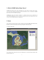
1. What is GABBS Python Maps Library?
GABBS Python Maps Library allows MyGeoHub users and scientists to display maps, images,
vectors and other geospatial information within their Hubzero Tools. It includes the GABBS
Python Maps API and GABBS Map Widgets
GABBSPython Maps API enables developers to customize maps and the information on
maps.GABBS MapWidgets provide a container for displaying maps without programming, which
is an easy way to integrate maps into an application.
2. Basics
In this section we will show how to create a simple map using the GABBS Python Maps Library.
We will start with a simple example and then go through the code step by step.
2.1 Create a simple map
This example creates a map show some vector of Michigan, U.S, and raster image of Purdue, West
Lafayette, Indiana, U.S.
1
Example:
# Create a Map Container
canvasProp = {'panControl': True,
'zoomControl': True,
'selectControl': True,
'layerControl': True }
self.mapContainer = gabbs.maps.MapContainer(canvasProp)
# Add canvas as a widget to the layout
self.layout.addWidget(self.mapContainer)
# Create a Map object
mapProp = {'center':
{'lon': -86.9080556,
'lat': 40.4258333},
'zoom':
8,
'maxZoom': 18,
'minZoom': 1,
'mapTypeId': 'OSM'}
self.map = gabbs.maps.Map(mapProp)
self.mapContainer.addLayer(self.map)
# Create a Raster object
filePath = os.path.join("/home/mygeohub/wanwei/geo", "data", "LC8_20130524.tif")
rasterProp = {"layerName":
"raster"}
rasterProp["fileName"] = filePath
self.raster = gabbs.maps.Raster(rasterProp)
self.mapContainer.addLayer(self.raster)
# Create a Vector object
filePath = os.path.join(".", "data", "Counties", "Counties.shp")
polygonProp = {"layerName":
"vector",
"strokeColor":
"strokeOpacity":
0.8,
"strokeWeight":
2,
"fillColor":
"fillOpacity":
"#0000FF",
(40, 200, 160),
0.5}
polygonProp["fileName"] = filePath
self.polygon = gabbs.maps.Vector(polygonProp)
self.mapContainer.addLayer(self.polygon)
# Create a Point object
filePath = os.path.join("/home/mygeohub/wanwei/geo", "data", "Burn_Point_Locations.csv")
markerProp = {"layerName":
"delimiter":
"layer",
",",
"xField":
"Longitude",
"yField":
"Latitude",
"useSystemStyle": True,
2
"styleName":
"SVG_MARKER_RED_MARKER"}
markerProp["fileName"] = filePath
self.point = gabbs.maps.DelimitedText(markerProp)
self.mapContainer.addLayer(self.point)
The rest of this section describes the above example step by step.
2.2. Load the GABBS MapsAPI
The GABBS Maps API is a Python library. It can be added to a Python main programas following:
import gabbs.maps
# Initialize gabbs maps library
gabbs.maps.gbsLoadLibrary()
#adding your codes here
…
# Unload gabbs maps library
gabbs.maps.gbsUnloadLibrary()
2.3. Create a map container
Create a mapContainerobject to contain the map. mapContaineris a widget in PyQT. Use layout to
size the element.
Note : The map will always "inherit" its size from its container layout.
In the initialize function, create adict object (canvasProp) to define the properties of the
mapContainer, such as enabling control panels on the toolbar. The following shows example code
that initializes the map container:
# Create a Map Container, aka map canvas
canvasProp = {'panControl': True,
'panControlOptions':
'zoomControl': True,
'selectControl': True,
'layerControl': True,
'overviewControl':True}
self.mapContainer = gabbs.maps.MapContainer(canvasProp)
# Add canvas as a widget to the layout
self.layout.addWidget(self.mapContainer)
2.4. Set map properties
The syntax for setting map properties follows the style of Google Maps API. All properties are
stored in a Python dictionary, where property nameis the key and property value is the value. And
the value is using native Python data types, such as Boolean, Integer, Float, and String.
In the initialize function, create a dict object (mapProp) to define the properties for the map. Here
are the steps to initialize a map:
# Create a Map object
3
mapProp = {'center':
{'lon': -85.508742,
'lat': 46.120850},
'zoom':
6,
'maxZoom': 18,
'minZoom': 1,
'mapTypeId': 'OSM'}
The center property specifies where to center the map. Create a Lat and Lonkey to center the map
on a specific point. Pass the coordinates in the order: longitude, latitude.The zoom property
specifies the zoom level for the map. A value of zero shows a map of the Earth fully zoomed out.
Higher zoom levels zoom in at a higher resolution.The mapTypeId property specifies the map type
to display. The following map types are supported:
OSM (Open Street Map)
2.5. Create a map object
The following code creates a new map inside the main window class with member variable name
"self.map ", using the parameters that are passed through mapProp.
self.map = gabbs.maps.Map(mapProp)
self.mapContainer.addLayer(self.map)
3. GABBS Maps Overlays
Overlays are objects on the map that are bound to latitude/longitude coordinates. Scientists can
use overlay to display result images. GABBS Maps supports several types of overlays:
Vector:
This includes (1) polyline which includes series of straight lines on a map,(2) polygon which
includes series of straight lines on a map and the shape is "closed",(3)circle, and (4) rectangle.
Raster:
This includes any GDAL supported image file format, such as tiff, geoTiff. The file may be single
band or multiband.
DelimitedText:
This includes CSV, or other text file. This is often symbolized as markerson a map which can also
display custom icon images.
In the future, GABBS Maps will support info windows, displaying content within a popup balloon
on top of a map, and other custom overlays.
3.1.Vector
A vector polygon is similar to a polyline in that it consists of a series of coordinates in an ordered
4
sequence. However, polygons are designed to define regions within a closed loop.Polygons are
made of straight lines, and the shape is "closed" (all the lines connect up).
A polygon overlay supports the following properties:
strokeColor - specifies a hexadecimal color for the line (format: "#FFFFFF")
strokeOpacity - specifies the opacity of the line (a value between 0.0 and 1.0)
strokeWeight - specifies the weight of the line's stroke in pixels
fillColor - specifies a hexadecimal color for the area within the enclosed region (format:
"#FFFFFF")
fillOpacity - specifies the opacity of the fill color (a value between 0 and 100)
visible- defines whether the layer is visible by users (true/false)
Here is an example:
# Create a Vector object
filePath = os.path.join(".", "data", "Counties", "Counties.shp")
polygonProp = {"layerName":
"vector",
"strokeColor": "#0000FF",
"strokeOpacity": 0.8,
"strokeWeight": 2,
"fillColor":
(40, 200, 160),
"fillOpacity":
0.5}
polygonProp["fileName"] = filePath
self.polygon = gabbs.maps.Vector(polygonProp)
self.mapContainer.addLayer(self.polygon)
3.2 Raster
A rasteroverlay supports the following properties:
opacity - specifies the opacity of the fill color (a value between 0.0 and 1.0)
visible- defines whether the layer is visible by users (true/false)
Here is an example:
filePath = os.path.join("/home/mygeohub/wanwei/geo", "data", "LC8_20130524.tif")
rasterProp = {"layerName":
"raster"}
rasterProp["fileName"] = filePath
self.raster = gabbs.maps.Raster(rasterProp)
self.mapContainer.addLayer(self.raster)Try it yourself
3.3 DelimitedText
The DelimitedTextoverlay constructor creates a point layer. (Note that the position property must
be set for the marker to display).Add the layer to the map by using the addLayer() method of
mapContainer object.
Here is an example:
# Create a Point object
5
filePath
=
os.path.join("/home/mygeohub/wanwei/geo",
"Burn_Point_Locations.csv")
markerProp = {"layerName":
"layer",
"delimiter":
",",
"xField":
"Longitude",
"yField":
"Latitude",
"strokeColor": "#0000FF",
"strokeOpacity": 0.8,
"strokeWeight": 2,
"fillColor":
(255, 0, 0),
"fillOpacity":
1}
markerProp["fileName"] = filePath
self.point = gabbs.maps.DelimitedText(markerProp)
self.mapContainer.addLayer(self.point)
"data",
4. GABBS Maps Events and Actions
4.1.Add an action to the map
Add an action that will execute a script function once a mouse click event is triggered when using
map tools. It is also possible to link the action to a specific layer of the maps on demand. It
provides an easy and safe way to add user defined functions to map events. In addition, user can
get map attributes by using built-in key words in the action. Please see the GABBS Maps Action
Reference for details.
The gbsAddAction function creates a GABBS Maps API action. The action script to perform
when an event is triggered is added as a parameter to the action.
Here is an example that shows a message box of clicked mouse coordinates when user clicks on
the map. It defines a “python” type of action to call the QMessageBox function. In the call to
gbsAddAction(), self.polygon is the target layer, "python" is the action type, "massage" is the
action name, “action1” is a string that contains thescript to be executed.
action1 = """
from PyQt4.QtCore import *
from PyQt4.QtGui import *
QMessageBox.information(None, "Info", "left button clicked x:[% $clickx %], y: [% $clicky %]
")
"""
gabbs.maps.gbsAddAction(self.polygon, "python", "massage", action1)
Below is another example that echoes an attribute value when a feature is clicked. It defines a
6
“generic” type of action to call the system echo command:
action2 = """ echo "[% "fpa_name" %]" """
gabbs.maps.addAction(self.point, "generic", "name", action2)
4.2 GABBS Maps Action Reference
Action Type:
Generic“generic”
tr( "Echo attribute's value" ), "echo \"[% \"MY_FIELD\" %]\"", "", true )
tr( "Run an application" ), "ogr2ogr -f \"ESRI Shapefile\" \"[% \"OUTPUT_PATH\" %]\" \"[%
\"INPUT_FILE\" %]\"", "", true );
Python“python”
Python, tr( "Get feature id" ), "QtGui.QMessageBox.information(None, \"Feature id\", \"feature
id is [% $id %]\")", "", false );
Python,
tr(
"Selected
field's
value
(Identify
features
tool)"
),
"QtGui.QMessageBox.information(None, \"Current field's value\", \"[% $currentfield %]\")", "",
false );
Python,
tr(
"Clicked
coordinates
(Run
feature
actions
tool)"
),
"QtGui.QMessageBox.information(None, \"Clicked coords\", \"layer: [% $layerid %]\\ncoords:
([% $clickx %],[% $clicky %])\")", "", false );
OpenUrl“open”
OpenUrl, tr( "Open file" ), "[% \"PATH\" %]", "", false );
OpenUrl, tr( "Search on web based on attribute's value" ), "http://www.google.com/search?q=[%
\"ATTRIBUTE\" %]", "", false );
Action Keywords:
[%$clickx %],[% $clicky%]
$clickx, $clicky keywords will be automatically replaced by the mouse cursor position when
a click event is triggered.
[% \"ATTRIBUTE\" %]
ATTRIBUTE keyword need to be the name of anattribute field, and the value of the attribute
field of certain feature will be required by the action tool.
4.3.Add an Event Listener to the Map
Add an event listener that will execute the user function on certain signal from the map object. It
is also possible to load the GABBS Maps API on demand.
This feature is currently under development.
7
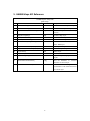
5. GABBS Maps API Reference
GABBS Python Maps API
gabbs.maps.
No
API
Return Value
Usage
1.
gbsLoadLibrary()
void
Initialize GABBS maps library
2.
gbsUnloadLibrary()
void
Exit GABBS maps library
3.
MapContainer(dict canvasProp)
MapContainer
Create a Map Container, aka map
canvas
4.
Map(dict mapProp)
Map
Create a Map layer
5.
Raster(dict rasterProp)
Raster
Create a Rasterlayer
6.
Vector(dict vectorProp)
Vector
Create a Vectorlayer
7.
DelimitedText(dict pointProp)
DelimitedText
Create a DelimitedText, CSV or
other WKTlayer
8.
MapContainer.addLayer(Layer)
void
Add layer to map canvas
9.
MapContainer.removeLayer(Layer)
void
Remove layer to map canvas
10.
Layer.show()
void
Show layer
11.
Layer.hide()
void
Hide layer
12.
Layer.setProperty()
void
Update layer’s properties and
styles
13.
gbsGetSelectedAttributes()
List[]
Get all attributes in selected
features of current layer
14.
gbsGetSelectedBounds()
QRectF
Get
the
bounding
box’s
coordinates of all selected features
of current layer
8