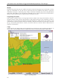
1
TOURIST INFORMATION VOICE SYSTEM (TIVS)
A location aware and feature triggered commentary system
for tour groups
Pramod Sharma, Devon Wilson and Stephen Kelly
A Location Aware and Feature Triggered Commentary System for Tour Groups
Disclaimer
The technical reports present data and its analysis, meta-studies and conceptual studies, and are considered to be
of value to industry, government or other researchers. Unlike STCRC’s Monograph series, these reports have not
been subjected to an external peer review process. As such, the scientific accuracy and merit of the research
reported here is the responsibility of the authors, who should be contacted for clarification of any content. Author
contact details are at the back of this report.
While all reasonable efforts have been made to gather the most current and appropriate information, the
Sustainable Tourism Cooperative Research Centre (STCRC) does not give any warranty as to the correctness,
completeness or suitability of the information, and shall in no event be liable for any loss or damage that might
be suffered as a result of reliance on this information.
We’d love to know what you think of our new research titles. If you have five minutes to spare, please visit
our website or click on the link below to complete our online survey.
STCRC Tech Report Feedback
National Library of Australia Cataloguing-in-Publication Entry
Tourist information voice system (TIVS) : a location aware and feature triggered commentary system for
tour groups / Pramod Sharma, Devon Wilson, Stephen Kelly.
ISBNs: 9781921521317 (pbk.), 9781921521324 (pdf).
Notes: Bibliography.
Subjects: Sightseeing business—Australia—Electronic information resources. Australia—Tours.
Other Authors/Contributors: Wilson, Devon. Kelly, Stephen James, 1970-.
Dewey Number: 338.47910285
Copyright © CRC for Sustainable Tourism Pty Ltd 2009
All rights reserved. Apart from fair dealing for the purposes of study, research, criticism or review as permitted
under the Copyright Act, no part of this book may be reproduced by any process without written permission from
the publisher. All rights reserved. Apart from fair dealing for the purposes of study, research, criticism or review
as permitted under the Copyright Act, no part of this book may be reproduced by any process without written
permission from the publisher. Any enquiries should be directed to:
General Manager, Communications and Industry Extension or Publishing Manager, [email protected]
First published in Australia in 2009 by CRC for Sustainable Tourism Pty Ltd
Printed in Australia (Gold Coast, Queensland)
Acknowledgements
The Sustainable Tourism Cooperative Research Centre, established and supported under the Australian
Government’s Cooperative Research Centres Program, funded this research. Map Data Sciences provided map
data for field testing. Field testing in WA was only possible thanks to support from Drive WA, who supplied
vehicles, accommodation, POI data etc.
ii
TOURIST INFORMATION VOICE SYSTEM (TIVS)
CONTENTS
SUMMARY _____________________________________________________________________________ V
TOURIST INFORMATION VOICE SYSTEM (TIVS) ________________________________________________ V
Bus Tour Version______________________________________________________________________v
Technologies ________________________________________________________________________ vi
Significance _________________________________________________________________________ vi
Key Stakeholders ____________________________________________________________________ vii
Advantages ________________________________________________________________________ vii
OBJECTIVES OF THE STUDY _______________________________________________________________ VII
METHODOLOGY _______________________________________________________________________ VIII
KEY FINDINGS _________________________________________________________________________ IX
FUTURE ACTIONS _______________________________________________________________________ X
TOURIST INFORMATION VOICE SYSTEM (TIVS) _________________________________________ 1
BACKGROUND __________________________________________________________________________
BUS TOUR VERSION _____________________________________________________________________
ENVIRONMENT _________________________________________________________________________
TECHNOLOGIES _________________________________________________________________________
STAKEHOLDERS ________________________________________________________________________
ADVANTAGES __________________________________________________________________________
SIGNIFICANCE __________________________________________________________________________
PURPOSE OF REPORT _____________________________________________________________________
1
2
3
3
3
4
4
4
METHODOLOGY _______________________________________________________________________ 5
COMMERCIAL PROTOTYPE ____________________________________________________________ 7
INDUSTRY PARTNERS ____________________________________________________________________ 7
SPECIFICATIONS ________________________________________________________________________ 7
INTERFACE ____________________________________________________________________________ 7
STORY BOARD ________________________________________________________________________ 12
PRE-TOUR ____________________________________________________________________________
Data Updates_______________________________________________________________________
Start Tour _________________________________________________________________________
Preamble __________________________________________________________________________
Throw Distance _____________________________________________________________________
On Tour ___________________________________________________________________________
General Interest Commentary __________________________________________________________
Breaks ____________________________________________________________________________
Long Range Location ________________________________________________________________
Video _____________________________________________________________________________
New Log___________________________________________________________________________
POST-TOUR ___________________________________________________________________________
12
12
12
12
12
13
14
16
16
16
17
17
MODULES ____________________________________________________________________________ 18
SPECIFICATIONS OF TIVS MODULES___________________________________________________ 20
LOOK AHEAD ALGORITHM _______________________________________________________________
DISPLAY _____________________________________________________________________________
GPS READING _________________________________________________________________________
DATA ACCESS _________________________________________________________________________
HISTORY _____________________________________________________________________________
USER INTERFACE ______________________________________________________________________
DATA CREATION _______________________________________________________________________
DATA UPDATE ________________________________________________________________________
SPEECH ______________________________________________________________________________
DATABASE STRUCTURE _________________________________________________________________
VIDEO _______________________________________________________________________________
MUSIC _______________________________________________________________________________
20
21
22
22
22
23
23
23
24
24
25
26
iii
A Location Aware and Feature Triggered Commentary System for Tour Groups
DATA ENTRY APPLICATION ______________________________________________________________ 26
Website ___________________________________________________________________________ 29
ISSUES________________________________________________________________________________ 30
EVALUATION _________________________________________________________________________ 31
BUSINESS MODEL AND FUTURE DEVELOPMENTS ______________________________________ 36
POTENTIAL BUSINESS MODEL FOR BUS TOUR PROTOTYPE _______________________________________ 36
POTENTIAL REVENUE MODEL FOR TAG ALONG TOURS _________________________________________ 36
ENHANCEMENTS REQUIRED FOR TIVS ______________________________________________________ 36
CONCLUSION _________________________________________________________________________ 37
APPENDIX A: LOOK AHEAD ALGORITHM ______________________________________________ 38
APPENDIX B: CONSIDERED FACTORS __________________________________________________ 41
AUTHORS_____________________________________________________________________________ 42
List of Figures
Figure 1: Interface for Bus Tour Prototype _____________________________________________________ 8
Figure 2: Selecting the Zoom Level ___________________________________________________________ 9
Figure 3: TIVS Laptop Settings______________________________________________________________ 10
Figure 5: Interface with Throw Distances Shown________________________________________________ 13
Figure 6: General Interest Boxes ____________________________________________________________ 15
Figure 7: Selecting Videos _________________________________________________________________ 16
Figure 8: Logging Information on your Location________________________________________________ 17
Figure 9: Layer Diagram __________________________________________________________________ 18
Figure: 10. Data Flow Diagram_____________________________________________________________ 19
Figure 11: Laptop Local Database Entity Relationship Diagram ___________________________________ 25
Figure 12: Sandbox Database Entity Relationship Diagram _______________________________________ 25
Figure 13: Data Entry Application–Tour Types _________________________________________________ 26
Figure 14: Data Entry Application–POI Data __________________________________________________ 27
Figure 15: Data Entry Application–Location Items ______________________________________________ 28
Figure 16: Data Entry Application–Videos ____________________________________________________ 28
Figure 17: Field Testing in Swan Valley ______________________________________________________ 31
Figure 18: TIVS Setup in 1 4WD ____________________________________________________________ 32
Figure 19: Field Testing En-route to Exmouth __________________________________________________ 32
Figure 20: The Pinnacles __________________________________________________________________ 33
Figure 21: HMAS Sydney Memorial__________________________________________________________ 34
Figure 22: Data Collection in the Cervantes ___________________________________________________ 34
iv
TOURIST INFORMATION VOICE SYSTEM (TIVS)
SUMMARY
Tourist Information Voice System (TIVS)
Location Based Services (LBS) are systems which utilise the location of a mobile device, in order to collect or
deliver information. They allow for the delivery of location and time specific, personalised, value added services
to users on the move. These services include: fleet tracking, concierge services, routing and navigation,
emergency services and tour guides. Such services are revolutionising the tourism industry, as they can support
the tourist in all three phases of their activity, particularly during the on tour stage. Until such services were
developed travellers relied on guidebooks, maps and tourist information centres for their on tour support. LBS
can enhance the knowledge and experience of the tourist by providing location and time specific information
(e.g. where is the nearest open museum?), as well as offering improved safety (e.g. weather alerts, emergency
response etc.). The key here is the delivery of services when consumers need them the most—that is, in
unfamiliar environments.
In recognition of the potential of Location Based Services for the tourism industry, this project set out to
demonstrate the value of LBS, and to build and evaluate applications for the Australian tourism industry. As part
of this project three prototypes were developed, one of which was Tourist Information Voice System (TIVS):
application 1. TIVS is a feature triggered, location aware and multilingual commentary system for tour groups,
vehicles, boats, pedestrians etc. The stakeholder focus for the application is the tour group travelling in a local
physical environment such as a city, national park or tour bus. The mobile technologies enabling it are Global
Positioning System (GPS), wireless technology and Geographic Information System (GIS).
As a result of our research we recognised the changing needs of travellers today (taking shorter breaks more
often, with limited time to spend planning a trip, wanting greater flexibility during the trip etc.) and the ways in
which a mobile commentary system could improve the experience and knowledge of today’s tourists. A
commentary system offers many advantages over the traditional guide books, maps and tourist information
centres. Guidebooks can be very bulky, difficult and heavy to carry around, and one often does not have time to
read all the details before or during a trip. Maps can also be a pain to carry around and difficult to follow
(especially tourist maps that are not to scale). Tourist information centres are not always open or accessible.
Tourism organisations such as museums and art galleries have offered audio commentaries (cassettes, CDs,
MP3 players etc.) for some time, but these also suffer from a number of limitations, namely users must follow a
set path, visit features in a set order and are restricted to features included in the audio. Mobile technologies,
however, mean that users can be delivered information on features based on their location (e.g. using GPS), can
follow any route and visit features in any order. They can receive information on any feature based on their
interests, and can easily skip features.
TIVS uses mobile technologies to deliver information on Points of Interest (POIs) according to the interests
of the traveller, their location, speed, direction etc. They can view their location on a map, as well as the location
of POIs. TIVS delivers audio, images, video and text, in order to enhance the experience and knowledge of
tourists. Real time up-to-date information on POIs mentioned in the commentary is another key feature.
Two prototypes were developed as part of this application—a bus tour version for notebook computers and a
pedestrian version for small screen devices. These two prototypes differ in terms of their interface and their
interactivity. The purpose of the bus tour version was to develop an application for tour groups, allowing
members of the group to receive audio commentary in any language. It was developed for notebook computers,
and provided the bus has a screen, tourists can also see their location on a map, the location of POIs mentioned
in the commentary, images, video, text etc. The purpose of the pedestrian version was to allow individuals to
receive audio commentary as they walk around a local environment (i.e. output for a single user).
Bus Tour Version
The bus tour version provides commentary in a tour group situation. In typical group tours, the tour guide can be
very hard to hear and understand (especially in urban environments), no matter how close you are to the tour
guide, and all members of the group jostle for a position close to the guide. All groups are also given the same
commentary. While many audio commentary systems do exist, they are not designed for group tours. TIVS
addresses these issues by providing personalised tour commentary to tour groups, whether they are travelling by
bus, boat, 4WD etc. The travellers can listen to the commentary using headphones and can also see text, images,
v
A Location Aware and Feature Triggered Commentary System for Tour Groups
maps etc. via the screen in the vehicle. Each tour will differ according to the interests of the group, the route
taken, the speed of the vehicle etc.
Before a tour begins the tour company loads the data for the tour (map data, POI data, music, general
commentary) onto the notebook. When the tour group boards the bus, the driver selects the type of tour the group
is interested in (e.g. architecture, history, wildflowers etc.) and whether to play music or general commentary
when there are no POIs to talk about. The tour then begins and the location of the bus is recorded using GPS.
The bus requires an LCD screen with a resolution of at least 1280 x 1024 pixels and a physical size of 17 inches,
so that the travellers can view the TIVS interface from anywhere in the bus. The focus of the interface is a map
showing the location of the bus and POIs.
For each POI (e.g. Parliament House) a number of attributes/items of commentary (e.g. This building was
built in 1894 on the site of the former ... ) are recorded in the database (as both text and MP3 files). A throw
distance is also entered for each POI (i.e. the distance within which the POI should be commented on) and items
are weighted according to tour types. Images can also be stored for each POI and their attributes.
Travellers can view their location and the location of POIs mentioned in the commentary on the map. When a
POI/item is being mentioned in the commentary it is highlighted on the map and if it has an associated image,
this is shown over the map. Audio commentary is received via headsets worn by each member of the group. If
MP3 files of the commentary are stored in the database, then these are the audio files delivered to the group. If,
however, the attributes are stored as text only, the text-to-speech engine is used. As audio commentary is being
delivered, it is also shown as text. The bus driver can also choose to show videos during the tour.
The look ahead algorithm calculates the POIs and the items to include in the commentary (based on the tour
type, location of the bus, throw distances, speed, direction etc.). The POIs and items are arranged in a queue and
the queue is updated whenever items of commentary are finished or every 15 seconds. TIVS is also able to
receive real-time updates to the commentary via GPRS.
During the tour the application records the POIs and items mentioned and this information could be used to
create a PDF showing the location of the POIs mentioned during the tour, lists of POIs and their URLs, which
can be downloaded from the web (post tour support).
Technologies
The technologies used for the commercial prototype include:
• GPS
• GIS
• Text-to-speech
• GPRS
• Bluetooth
• SQL Server
• Data sync
• .Net framework 2.
Significance
The significance of TIVS is:
• It is a ‘geography smart’ tour guide for tour groups and individuals, delivering audio, text and graphics
via mobile devices.
• It is a multi-lingual tour guide (commentary can be delivered in any language, provided the information
is recorded in the database in the appropriate language)
• Its delivery of ad hoc commentary incorporates the look ahead algorithm for POI detection this detects
and arranges POIs and items in a queue according to tour type, bearing, speed, distance etc.
• On the fly updates can be received via GPRS.
vi
TOURIST INFORMATION VOICE SYSTEM (TIVS)
Key Stakeholders
Stakeholders
Tourism
Organisations
Tourists
Benefits
Improved service offerings (superior, value-added, personalised services)
Supports the tourist in all three phases of their activity
Improved services for group tours
Potential source of revenue
Improved access to SMTEs and tourism organisations
Improves the experience and knowledge of the traveller
Personalised, value-added, location and time specific services (Information by: the
interests of the group or individual; the location of the tourist/vehicle; able to
receive real-time updates via GPRS)
Improved safety
Improves the experience in a group tour situation
Increased satisfaction of the traveller
Advantages
TIVS offers tourists many advantages:
• personalised commentary according to user interests
• commentary in any language (provided information is stored in the database in the appropriate
language)
• support for group tours
• improved knowledge of a location (as it delivers information via audio, text, images and video)
• provides greater flexibility to the travellers as they do not have to follow a set route and can choose to
visit POIs in any order
• the delivery of ad hoc commentary
• the look ahead algorithm determines which POIs and items to mention in the commentary depending on
your interests, the speed and direction you are travelling in etc.
• allows for the delivery real-time up-to-date information—on the fly updates
• can be used for any length of tour—a one hour tour or a tour lasting 2 weeks
• application can also be used to train and prompt tour guides
Objectives of the Study
The purpose of the current study was:
• to develop a ‘commercial prototype’ of TIVS by completing software development, calibration and
field testing for application 1 developed as part of project STCRC project 80050;
• to develop a website to support LBS solutions for the Australian travel and tourism industry.
Two prototypes were developed as a result of application 1 (STCRC project 80050): a pedestrian prototype
and a bus tour prototype. The bus tour prototype was the one chosen to develop into a ‘commercial prototype’.
The reason for this choice was the need for support for group tours (an important market for tourism in
Australia) and the lack of existing applications in this area.
vii
A Location Aware and Feature Triggered Commentary System for Tour Groups
Methodology
No.
1
Module
Interface
2
Look Ahead Algorithm
Decides on the optimum POIs and
items to mention during the tour, this
will depend on a number of factors
such as tour type, bearing, distance,
speed etc.
Map Display
Draws information on-screen; shows
arrows and location of bus
Speech
Plays direction speech on first location
item of each POI. Says sound files.
Online Update
Allows users to view real-time up-todate information via GPRS
4
5
6
7
8
9
10
11
12
13
14
15
16
viii
GPS
Reads
current
location
of
bus/pedestrian and converts to UTM
coordinates
Trip Log
Records POIs and items (trip log in
SQLite) mentioned in commentary
Video
Allows tourists to view short videos on
POIs and regions
Data Entry Interface
Application for entering data on POIs
(text, sound files and images) and
general commentary
Map Data Preparation
Maps show streets, parks, water, land
etc.
Music
Background music to play in periods of
silence
General
Field Testing
Website
Allowing access to online updates;
users can download and upload GPS
tours; access PDF
Documentation
Tasks
Enhancement of map interface
Improve timing (e.g. map location every 1 second, features
every 3 seconds)
Choice of music or general commentary for gaps
Pause button
Improvements to efficiency and overall enhancement
Field testing and calibration
Implement dynamic visualisation effects
Allow for 3 zoom levels
Fine tuning
Interface with text-to-speech engine
text-to-speech conversion and testing
Application on web server allowing updates to be sent and
received
Real world testing
Implement text-to-speech conversion
Generalised GPS capture (improve current version by making
it more generic and better at handling error corrections)
Implement auto-find for GPS devices
Change to Mercator owing to problem of crossing UTM zones
Driver can give tour details to tour company via USB,
allowing them to develop strategies for post-tour support
Ability to run stand alone video
Drivers can choose from drop down list – 1 hr, 30 min, 20 min,
10 min videos
Support DivX and MPEG
Uses Windows Media Player
Develop a data entry application for POIs, including localised
text and text-to-speech
Input POI data for field testing
Define general interest areas for general commentary
Obtain map data for QLD and Western Australia
Generalise data
Manipulate and symbolise data
Background music (MP3 files)
Randomised selection of music using Windows Media Player
At least 1 hour of music
Improve code, scalability, system architecture, performance
Detailed testing of calibration and testing on different
geographic scales
Web server for real-time updates
Technical and user manuals
Update diagrams
TOURIST INFORMATION VOICE SYSTEM (TIVS)
Key Findings
Field testing of the commercial prototype was carried out in Brisbane and in Western Australia. The application
performed very well. Field testing in Brisbane was undertaken largely in the Graceville area, driving in a car, and
walking around the park. The application was installed on a notebook computer and required the use of a GPS
receiver. While a few small issues were identified, they were quickly rectified, and TIVS was deemed to be
ready to be tested during a real tour.
The real-world testing of TIVS was carried out in Western Australia. While this commercial prototype was
designed for bus tours, testing in Western Australia was undertaken for tag along tours or global gypsies type
tours. Testing was undertaken with Drive Western Australia. These are the types of tours they envisage TIVS
being used for. Hence, testing was undertaken in 4WDs with TIVS being used in two of the three vehicles. As
the interface was designed for bus tours, so that users could view the screen from the back of the bus, several
changes are required for tag along tours in a 4WD.
• Places and roads should be labelled.
• Map data is too generalised.
• Roads layer must be split up into streets, railways etc.
• Interface should have a legend and scale.
• Users should be able to click on places to find out more information—interactive
• Symbolisation needs to be to be changed—colour, line thickness etc. Users can choose different modes
offering different symbolisation.
• Interface should include how far travelled.
• Users should be able to zoom in and out.
• Head phones cannot be worn by the driver of the vehicle and are not necessary in this environment.
• FM transmitters improve sound quality.
Initial testing in Western Australia was undertaken in the Swan Valley and TIVS performed extremely well
in this local environment. Some issues identified were:
• Throw distances entered were too large and need to be tested (suitable distances vary according to the
type of POI and topography). It will take some fine tuning to get this right
• Pre-recorded MP3 files were the better means of delivering audio commentary, as text-to-speech was
not natural, missed emphases, was too fast etc.
TIVS was then evaluated during a six day trip from Perth to Geraldton, Carnarvon, Exmouth and back to
Perth. This tour encompassed a range of different environments, with varying densities of POIs. The following
issues were identified during this trip:
• Battery lives of laptop and GPS were an issue, unless the car has an inverter or a car charger.
• Inverters and car chargers only work while the engine is on.
• A rugged notebook is required.
• Size and weight of notebook.
• Volume was an issue in the car, until we used an FM transmitter.
• The heat emitted by a notebook is a significant problem if the notebook in on someone’s lap.
• GPS devices drop out from being unplugged and the computer going to sleep.
• There was a loss of Bluetooth connection between GPS and notebook (unstable).
• Many cables are required—GPS connection, notebook recharger, FM transmitter, camera etc.
• Recharging devices at night—GPS, notebook etc. is a problem if camping.
• Large distances exist between POIs in outback (large areas with no commentary).
• 4WDs are very bumpy and it was difficult to click on buttons under such conditions (buses are more
stable and offer a smoother ride).
• Additional commentary is needed on areas where POIs might be (e.g. ‘whales can often be seen along
the coast ahead’ or ‘you are entering a wildflower area’)—area rather than point features.
• Distances between updates is a significant issue—GPRS coverage is often only available in the towns
and so updates for all possible POIs ahead (before the next location where GPRS coverage is available)
need to be obtained. How should the update area be defined?
• Road noise is an issue.
• Commentary should include information on topographic features, vegetation, geology etc.
• TIVS should be used to deliver safety information to tourists. This is very important for the Outback.
• The interface should show coordinates in decimal degrees.
ix
A Location Aware and Feature Triggered Commentary System for Tour Groups
Future Actions
The testing of this prototype led to the identification of the significance of TIVS for 4WD tag along type tours.
The following enhancements must occur in order to take TIVS to the next stage:
• Interactive version for 4WD/tag along tours needs to be created
• Identify suitable hardware for 4WD use
• Incorporate navigation/routing into TIVS
• Incorporate safety information into TIVS
• Make TIVS more interactive for ease of use
• Incorporate information on hotels; online bookings?
• Add data collected during test in Western Australia to POI database.
x
TOURIST INFORMATION VOICE SYSTEM (TIVS)
Chapter 1
TOURIST INFORMATION VOICE SYSTEM (TIVS)
Background
Location Based Services (LBS) are systems which utilise the location of a mobile device, in order to collect or
deliver information. They allow for the delivery of location and time specific, personalised, value added services
to users on the move. These services include: fleet tracking, concierge services, routing and navigation,
emergency services and tour guides. Such services are revolutionising the tourism industry, as they can support
the tourist in all three phases of their activity, particularly during the on tour stage. Until such services were
developed travellers relied on guidebooks, maps and tourist information centres for their on tour support. LBS
can enhance the knowledge and experience of the tourist by providing location and time specific information
(e.g. where is the nearest open museum?), as well as offering improved safety (e.g. weather alerts, emergency
response etc.). The key here is the delivery of services when consumers need them the most—that is in
unfamiliar environments.
While these services are predominantly consumer services, consumers are also driving the adoption of such
services in the workplace. Mobility is the future of business and consumer services and the most successful
players will be those that allow consumers to be mobile and connected. Consumers are driving the demand for
access to information, services and applications anywhere, anytime. Such mobile applications offer users a more
efficient and cost effective means of performing existing tasks (Peterson 2007). Tourism is just one area in
which LBS can improve the user’s experience and knowledge.
The on tour support of the traveller, has traditionally been through the use of printed guide books, maps,
tourist information centres and tour guides. Printed guidebooks, however, are heavy and bulky to carry around,
and are difficult to read whilst on the move and still see the sights. Furthermore, many travellers do not have the
time to read a guidebook before or during a trip. and Maps can also be awkward to carry around and difficult to
follow (especially tourist maps that are not to scale). Tourist information centres are not always open or
accessible. With regard to tour guides, tours are conducted in groups with everyone jostling to see and hear; the
commentary can be difficult to hear and understand; each group receives the same commentary.
In order to address some of these issues, many tourism organisations have developed audio commentaries for
individuals (cassettes, CDs, MP3 players etc.) for museums, historic sites, exhibitions etc. These audio
commentary systems, however, still require customers to follow a set route and to keep pace with the
commentary (or stop and start the audio). It is difficult to skip exhibits or items and many items of interest are
not mentioned. While commentary can be provided in different languages, all users receive the same
commentary regardless of their interests (e.g. Tourcaster, Tours by MP3, Tour Mate etc.).
In recognition of these limitations and the changing needs of tourists (taking shorter breaks more often, with
limited time to spend planning a trip, wanting greater flexibility during a trip etc.), a new range of audio tour
guides have been developed, which deliver audio commentary based on the location of the customer. The
location of the traveller is identified using a variety of means, including GPS, infrared, Bluetooth and RFID
technology. These audio guides allow users to choose their own route, view exhibits in any order and to move at
their own pace (e.g. Travel by GPS Tour Guides, Audio Augmented Reality, BEATS, Frontier GPS Tour Guide
etc.). Owing to advances in mobile technology and the increased consumer demand for services anywhere,
anytime, a number of these audio guides now offer personalised and location aware audio commentary
(personalised according to interests, language preference etc.). Some also allow access to multimedia content via
small screen devices (e.g. Antenna Audio, ATS Heritage Audio Tours, Node Explorer Multimedia Tour Guide).
These new guides recognise the importance of visual content.
1
A Location Aware and Feature Triggered Commentary System for Tour Groups
TIVS was developed in this context and is the culmination of several STCRC projects. The purpose of the
project #70164 was to carry out a scoping study for the use of Location Based Services for the Australian
Tourism Industry. This study examined the potential of LBS, existing prototypes and applications, and the
challenges and limitations associated with the development of such applications. As a result of this scoping study
several potential application areas were identified. The purpose of project #80050 was to develop and evaluate
applications identified in project #70164. Three LBS prototypes (and a supporting application) were developed
and evaluated. TIVS was one of these.
The objective was to develop and evaluate a position-based commentary system, including feature-triggered
commentary for exhibitions, tour vehicles, buses, pedestrians etc. TIVS is a feature triggered multi-lingual tour
guide for tour groups and individuals in a local environment (e.g. Brisbane). It uses GIS, GPS and wireless
technologies in order to support the tourist in the on-tour phase of their activity. The aim of the application is to
enable travellers to receive audio commentary based on their location. Travellers can also view their location and
the location of POIs on a map. As a tour group or individual travels around a local environment, the location of
the bus or tourist is recorded using GPS and TIVS delivers audio commentary to individuals based on their
location (proximity to various POIs) and interests (tour type). For example, a user may specify architecture as
their primary interest, in which case the commentary will give a higher weighting to such information.
The application not only allows for the delivery of location specific and personalised information, but also
organises the commentary on the POIs in a queue, in order to optimise the delivery of suitable information. TIVS
uses mobile technologies to deliver information on POIs according to the interests of the traveller, their location,
speed, direction etc. TIVS delivers audio, images, video and text, in order to enhance the experience and
knowledge of tourists. Real time up-to-date information on POIs mentioned in the commentary is another key
feature.
Two TIVS prototypes were developed for project #80050—a bus tour version for notebook computers and a
pedestrian version for small screen devices. These two prototypes differed in terms of their interface and their
interactivity. The purpose of the bus tour version was to develop an application for tour groups, allowing
members of the group to receive audio commentary in any language. It was developed for notebook computers,
and provided the bus has a screen, tourists can see their location on a map, the location of POIs mentioned in the
commentary, images, video, text etc. The purpose of the pedestrian version was to allow individuals to receive
audio commentary, images, video, text etc. as they walk around a local environment (i.e. output for a single
user).
The objectives of this current study (the subject of this report) were:
• to develop a ‘commercial prototype’ of TIVS by completing software development, calibration and
field testing for application 1 developed as part of project #80050;
• to develop a website to support LBS solutions for the Australian travel and tourism industry.
The bus tour prototype was the one chosen to develop into a ‘commercial prototype’. The reason for this
choice was the need for support for group tours (an important market for tourism in Australia) and the lack of
existing applications in this area.
Bus Tour Version
The bus tour version provides commentary in a tour group situation. In typical group tours the tour guide can be
very hard to hear and understand (especially in urban environments), no matter how close you are to the tour
guide and all members of the group jostle for a position close to the guide. All groups are also given the same
commentary. While many audio commentary systems do exist, they are not designed for group tours. TIVS
addresses these issues by providing personalised tour commentary to tour groups, whether they are travelling by
bus, boat, 4WD etc. The travellers can listen to the commentary using headphones and can see text, images,
maps etc. on the screen of the bus/laptop. Each tour will differ according to the interests of the group, the route
taken, the speed of the vehicle etc.
Before a tour begins the tour company loads the data for the tour (map data, POI data, music, general
commentary) onto the notebook. When the tour group boards the bus the driver selects the type of tour the group
is interested in (e.g. architecture, history, wildflowers etc.) and whether to play music or general commentary
when there are no POIs to talk about. The tour then begins and the location of the bus is recorded using GPS.
The bus requires an LCD screen with a resolution of at least 1280 x 1024 pixels and a physical size of 17 inches,
so that the travellers can view the TIVS interface from anywhere in the bus. The focus of the interface is a map
showing the location of the bus and POIs.
2
TOURIST INFORMATION VOICE SYSTEM (TIVS)
For each POI (e.g. Parliament House) a number of attributes/items of commentary (e.g. This building was
built in 1894 on the site of the former ... ) are recorded in the database (as both text and MP3 files). A throw
distance is also entered for each POI (i.e. the distance within which the POI should be commented on) and items
are weighted according to tour types. Images can also be stored for each POI and their attributes.
Travellers can view their location and the location of POIs mentioned in the commentary on the map. When a
POI/item is being mentioned in the commentary it is highlighted on the map and if it has an associated image,
this is shown over the map. Audio commentary is received via headsets worn by each member of the group. If
MP3 files of the commentary are stored in the database, then these are the audio files delivered to the group. If,
however, the attributes are stored as text only, the text-to-speech engine is used. As audio commentary is being
delivered, it is also shown as text. The bus driver can also choose to show videos during the tour.
The look ahead algorithm calculates the POIs and the items to include in the commentary (based on the tour
type, location of the bus, throw distances, speed, direction etc.). The POIs and items are arranged in a queue and
the queue is updated whenever an item of commentary is completed or every 15 seconds. TIVS is also able to
receive real-time updates to the commentary via GPRS.
During the tour the application records the POIs and items mentioned during the tour and this information
could be used to create a PDF showing the location of the POIs mentioned during the tour (including lists of
POIs and their URLs), which can be downloaded from the web (post tour support).
Environment
The tourist environment covered by this application is the local tourist environment, such as Brisbane, the Blue
Mountains, the Gold Coast, a national park or tour bus. Currently the application is restricted to outdoor
environments, owing to the positioning technology used (i.e. GPS).
Technologies
The technologies used for the commercial prototype include:
• GPS
• GIS
• Text to speech
• GPRS
• Bluetooth
• SQL Server
• Data sync
• .Net framework 2.
Stakeholders
The stakeholder focus for this ‘commercial prototype’ is the tour group travelling in a local physical
environment such as a national park or tour bus. This application will allow tourism organisations and SMTEs to
provide superior tours to travellers. In particular, it allows tour companies offering guided tours to enhance their
services through the delivery of feature triggered commentary in any language.
The stakeholders are:
• Tourism organisations and SMTEs offering guided tours for tour groups
o Bus
o Train
o Boat
o Etc.
TIVS offers many advantages to both tourism organisations and travellers (business and leisure travellers).
3
A Location Aware and Feature Triggered Commentary System for Tour Groups
Stakeholders
Tourism
Organisations
Tourists
Benefits
• Improved service offerings (superior, value-added, personalised services)
• Supports the tourist in all three phases of their activity
• Improved services for group tours
• Potential source of revenue
• Improved access to SMTEs and tourism organisations
• Improves the experience and knowledge of the traveller
• Personalised, value-added, location and time specific services
(information by: the interests of the group or individual; the location of
the tourist/vehicle; able to receive real-time updates via GPRS)
• Improved safety
• Improves the experience in a group tour situation
• Increased satisfaction of the traveller
Advantages
TIVS offers tourists many advantages:
• Commentary can be personalised according to user interests.
• Commentary can be in any language (provided information is stored in the database in the appropriate
language).
• Group tours are supported.
• Location knowledge is improved (as it delivers information via audio, text, images and video).
• It provides greater flexibility to the travellers as they do not have to follow a set route and can choose to
visit POIs in any order.
o The delivery of ad hoc commentary
• The look ahead algorithm determines which POIs and items to mention in the commentary depending
on your interests, the speed and direction you are travelling in etc.
• It allows for the delivery real-time up-to-date information—on the fly updates.
• It can be used for any length of tour—a one hour tour or a tour lasting two weeks.
• The application can also be used to train and prompt tour guides.
Significance
TIVS offers a unique service to tourists in many ways. It is quite different to other LBS applications for the
tourism industry in that:
• It is a ‘geography smart’ tour guide for tour groups and individuals.
• It delivers audio, text and graphics via mobile devices.
• It is a multi-lingual tour guide (commentary can be delivered in any language, provided the information
is recorded in the database in the appropriate language).
• It allows for the delivery of ad hoc commentary.
• It allows for on-the-fly updates (synchronisation) via GPRS.
• The Look ahead Algorithm for POI detection detects and arranges POIs and items in a queue according
to tour type, location, bearing, speed, distance etc.
The application was also written in-house, eradicating the need to publish third party libraries. Hence, it
offers greater flexibility in the pricing of the final product.
Purpose of Report
This report is intended for STCRC, in order to provide information on the ‘commercial prototype’ of TIVS—
what the application can do, its purpose and significance, how it works; as well as technical information on the
system, in particular the modules, their role, issues and scope. This report also discusses the results of field tests
in Queensland and Western Australia, as well as future enhancements required for tag along type tours.
4
TOURIST INFORMATION VOICE SYSTEM (TIVS)
Chapter 2
METHODOLOGY
No.
1
Module
Interface
2
Look Ahead Algorithm
Decides on the optimum POIs and items
to mention during the tour, this will
depend on a number of factors such as
tour type, bearing, distance, speed etc.
4
Map display
Draws information on-screen; shows
arrows and location of bus
5
Speech
Plays direction speech on first location
item of each POI. Says sound files.
Online Update
Allows users to view real-time up-todate information via GPRS
6
7
GPS
Reads current location of bus/pedestrian
and converts to UTM coordinates
Tasks
• Enhancement of map interface
• Improve timing (e.g. map location every 1 second,
features every 3 seconds)
• Choice of music or general commentary for gaps
• Pause button
• Improvements to efficiency and overall enhancement
• Field testing and calibration
•
•
•
•
•
Implement dynamic visualisation effects
Allow for 3 zoom levels
Fine tuning
Interface with text-to-speech engine
text-to-speech conversion and testing
•
Application on web server allowing updates to be sent
and received
Real world testing
Implement text-to-speech conversion
Generalised GPS Capture (improve current version by
making it more generic and better at handling error
corrections
Implement auto-find for GPS devices
Change to Mercator owing to problem of crossing
UTM zones
Driver can give tour details to tour company via USB,
allowing them to develop strategies for post-tour
support
Ability to run stand alone video
•
•
•
•
•
8
9
10
Trip log
Records POIs and items (trip log in
SQLite) mentioned in commentary
Video
Allows tourists to view short videos on
POIs and regions
Data Entry Interface
Application for entering data on POIs
(text, sound files and images) and
general commentary
11
Map Data Preparation
Maps show streets, parks, water, land
etc.
12
Music
Background music to play in periods of
silence
•
•
•
•
•
•
•
•
•
•
•
•
•
•
—
Drivers can choose from drop down list
1 hr, 30
min, 20 min, 10 min videos
Support DivX and MPEG
Use Windows Media Player
Develop a data entry application for POIs, including
localised text and text-to-speech
Input POI data for field testing
Define general interest areas for general commentary
Obtain map data for Queensland and Western Australia
Generalise data
Manipulate and symbolise data
Background music (MP3 files)
Randomised selection of music using Windows Media
Player
At least 1 hour of music
5
A Location Aware and Feature Triggered Commentary System for Tour Groups
No.
13
Module
General
14
Field Testing
15
Website
Allowing access to online updates; users
can download and upload GPS tours;
access PDF
Documentation
16
6
Tasks
• Improve code, scalability, system architecture,
performance
• Detailed testing of calibration and testing on different
geographic scales
• Web server for real-time updates
•
•
Technical and user manuals
Update diagrams
TOURIST INFORMATION VOICE SYSTEM (TIVS)
Chapter 3
COMMERCIAL PROTOTYPE
Industry Partners
SJK Consulting; Drive Western Australia
Specifications
The technologies used for the prototype include GIS software (MapWinGIS), GPS receivers, notebook
computers and GPRS. The Master database is in SQL Server; the applications uses SQLite, Bluetooth, data sync
and was written in Visual Studio.net using .Net framework 2. The software for visualising the data and reading
GPS locations was written in-house. The GPS receiver is important for identifying the location of the bus or
tourist. The prototype also supports both the unconnected and connected mobile tourist. The unconnected mobile
tourist is unable to receive real-time data updates during the tour. In areas where users have access to a wireless
network (GPRS), they are able to received real-time up-to-date information and so are ‘connected’ mobile
tourists. The coverage of wireless networks is a major issue for this application (see below).
Interface
The interface for the bus tour prototype was developed for a notebook computer (see Figure 1). The assumptions
made are that the bus has an LCD screen with a minimum resolution of 1280 x 1024 pixels and a minimum size
of 17 inches. The focus of the screen is a map showing the location of the bus, the location of POIs (in blue); the
last POI featured in the commentary (in yellow) and the current POI featuring in the commentary (in red); as
well as yellow and red arrows pointing to the last POI featured in the commentary (yellow) and the current POI
featuring in the commentary (red). The location of the bus is recorded by GPS (every second) and the map is
updated every three seconds. The map faces the same direction as the bus (rather than north) and the map data
includes the street network, parks, rivers, railway lines, towns etc. There are three zoom levels and the zoom
level chosen will depend in the speed of the bus, but users can also select a particular zoom level (see Figure 2).
The interface also includes the time and a summary of what has been said. The commentary can be provided in
any language, provided the data is entered in the database in the appropriate language, although labels, menus
etc. are currently in English only. Whenever the system comments on a POI, it records the location of the
vehicle, the POI and item ID, and the time in a trip log (database table).
For this prototype the bus driver will be required to turn on the laptop, open the application, connect to the
GPS, enter the tour type required for the tour group and choose whether to play music or general commentary in
periods of silence (see Figure 3). The interface is fairly simple, to make it easy for the bus driver. The tour
companies who choose to use this system will be given a detailed manual on how to set it up (i.e. a user manual).
They will also have the option of having the application set up for them for a fee, although they will have to
enter their own tour information (tour types, POIs, throw distances and attributes).
7
A Location Aware and Feature Triggered Commentary System for Tour Groups
Figure 1: Interface for Bus Tour Prototype
8
TOURIST INFORMATION VOICE SYSTEM (TIVS)
Figure 2: Selecting the Zoom Level
9
A Location Aware and Feature Triggered Commentary System for Tour Groups
Figure 3: TIVS Laptop Settings
10
TOURIST INFORMATION VOICE SYSTEM (TIVS)
Master Database
SQL Server
Data
Business Rules
GPRS
Bus Interface
Internet
Web Server
Figure 4: System Architecture
11
A Location Aware and Feature Triggered Commentary System for Tour Groups
Chapter 4
STORY BOARD
Pre-Tour
The tour company must load the data for the tour. This includes the map data (streets, landuse, rivers), POI data
(tour types, POIs, their coordinates, URLs, items of commentary, images, MP3 files), videos, general
commentary and music. The recommended maximum per POI is 1.5 MB (650 POIs/GB or 6500 POIs per 10
GB).
Data Updates
The whole database should be replaced/updated each month, preferable using a USB drive rather than a wireless
network. If any POIs or items change then the whole database must be updated. The application is also able to
receive real-time updates based on the location of the tour vehicle. An application on a central server allows for
updates to be received and sent. They are text only and delivered using text-to-speech.
Start Tour
When the tour starts (when the group boards the bus), the driver selects the tour type (architecture, wildflowers,
history, shopping etc.) and whether to play the general commentary or music during gaps in commentary of over
two minutes. When the tour begins the location of the bus is recorded using GPS.
Preamble
The first POI in the database is a ‘fake’ POI designed to trigger an introduction to the tour (pictures, images and
audio). Its location is chosen so that the introduction will not interfere with the commentary to come. When the
bus reaches the throw of this POI, the introduction is triggered.
Throw Distance
Each POI has a specified throw distance, which is entered into the POI database. This is the distance within
which the POI should be commented on (see Figure 5). For example, the throw distance of a restaurant may be
200 m and the throw distance for a vineyard 600 m. The distance chosen will depend on the type of POI and the
topography. The recommended minimum throw is 100 m and the recommended maximum is 40 km (e.g. for a
mountain). If the vehicle does not enter the throw distance, the POI will not be mentioned.
These distances must be carefully chosen and may need fine tuning by the tour company. If inappropriate
distances are entered, the POI may not be commented on despite the close proximity of the vehicle, or the item
may be commented on even though the POI is some distance away on the other side of the river and cannot be
seen.
12
TOURIST INFORMATION VOICE SYSTEM (TIVS)
Figure 5: Interface with Throw Distances Shown
On Tour
As the bus continues along its route, the system calculates which POIs and items to include in the commentary.
If there are no POIs for the next two minutes, the overview map is shown (Level 3). If after two minutes there
are still no POIs, the system will play music or the general commentary. At least one hour of music should be
stored as individual MP3 files. The music is then randomly selected by the system. When the system identifies
POIs and items to include in the commentary, the map switches to a more localised map and the music or general
interest commentary stops.
The commentary for each POI is stored in a master database. For each POI a number of attributes/items of
commentary are recorded (we have been using a maximum of 10, but any number can be used). The title of the
POI is treated as an attribute and the database records commentary as text and MP3 files. If it is stored as MP3
files then they are used to deliver audio commentary. Each sound file can be up to 15 seconds. If the
commentary is stored as text only, then the text-to-speech engine is used (text-to-speech should also be up to 15
seconds). POIs and items of commentary are also weighted according to tour type.
The Look Ahead Algorithm calculates which POIs and items to include in the commentary. The POIs and
items are arranged in a queue and the queue is updated whenever an item has finished being commented on (or
every 15 seconds). If the sound file is only six seconds long, then the algorithm is recalculated after six seconds.
The system calculates which POIs to include in the commentary based on the location’s default value, tour type
13
A Location Aware and Feature Triggered Commentary System for Tour Groups
modifier, bearing, distance, throw distance etc. (see Appendix A). The items of commentary on the POI are
chosen based on the POI’s final value, tour type modifier and the location items default value (see Appendix A).
There are up to 30 factors which could be used and the algorithm relies on precise trigonometry (see Appendix
B). Once a location’s item ranking is less than the ranking of the next POI’s first item, that POI will no longer be
discussed and commentary on the next POI will begin (see Appendix A). Tenacity values determine how far
ahead the system will look and the default is 2 minutes (8 x 15 second slots). The system will try to fill the entire
queue with commentary. Nor is commentary on POIs repeated during a single tour. If the vehicle is stopped (e.g.
at traffic lights) the commentary will continue to play, but if it stops for more than 2 minutes, the general
commentary or music will play.
There is potentially a photograph or image associated with each item in the database. It is important to have a
photograph of each POI to help tourists identify the POI being commented on. Recommended image size is a
maximum of 100 kb. If a photo is associated with a POI, then it will be shown over the map.
The bus is also able to receive real-time updates to the commentary via GPRS (e.g. the tiger exhibit at Dream
World is closed for the day). The system looks for updates within a certain distance or geographical box (5
minutes ahead) and checks for updates every two minutes. The coordinates of the vehicle are sent to the server
and the server then searches for updates and sends the text to the bus. Updates are text only (maximum of 150
characters) and the text-to-speech engine converts it to audio (15 seconds maximum). If there is no GPRS
coverage, then no updates can be received. There is only one update per POI and once it is said, it is thrown out
(not cached). Not all updates sent to the vehicle will be said, as they may not all fall within the area for which
commentary is calculated. The tour/bus company must have suitable GPRS plans to allow for updates.
General Interest Commentary
The general interest commentary is general commentary on a region such as Brisbane, the Gold Coast or Perth
and can include any information on the region such as demographics, history, vegetation, weather etc. It will
only be played if the driver of the vehicle selects to play general interest commentary when there are gaps in the
commentary of more than two minutes.
Each state is divided into non-overlapping boxes, with boxes equating to tourism regions (see Figure 6).
General commentary for each region is recorded in the POI database and audio should be recorded in a different
voice to the POI data, to allow travellers to distinguish between the two commentaries. The general interest
commentary for each tourism region should contain at least 100 items (each up to 15 seconds). If the audio is
recorded as MP3 files then they will be said, otherwise the text-to-speech engine will be used. Once items of
general interest commentary are said, they cannot be repeated within one hour. In this case, music will play in
the meantime.
14
TOURIST INFORMATION VOICE SYSTEM (TIVS)
Figure 6: General Interest Boxes
In a single tour, the vehicle may travel through several general interest regions and the system will deliver the
commentary relevant to the location of the bus. When the general interest commentary is being played the map
will be displayed at Level 2. Images may also be attached to each item in the general interest commentary and
will be displayed over the map.
15
A Location Aware and Feature Triggered Commentary System for Tour Groups
Breaks
During the day the bus may stop at a number of locations to allow the tour group to get out of the bus, view the
sights, buy refreshments etc. For this reason a pause button has been included on the interface to pause the
commentary (see Figure 1). When the group is ready to resume the commentary they click on the pause button
again. If the pause button is not used, then the commentary for the current location will be said and after 2
minutes of silence either the music or general interest commentary will start.
Long Range Location
If the vehicle is within the throw of a long range location (a feature with a large throw distance), such as a
mountain, then the system will wait until the queue is empty before inserting it in the commentary. If there is
nothing else to say the system will comment on all items straight away. If the system is busy, however, it will
wait until there is space into which to insert the commentary. The closer the vehicle is, the less space it will look
for (e.g. at 10 km the system looks for 10 items, at 9 km for 9 items etc.). Once the vehicle is within 5 km it is
treated as a normal feature.
Video
Tourists can also view videos as they travel around. Drivers can choose from 1 hour, 30 minute, 20 minute or 10
minute videos. DivX and MPEG formats are supported and videos are played using Windows Media Player.
Figure 7: Selecting Videos
16
TOURIST INFORMATION VOICE SYSTEM (TIVS)
New Log
Users can also record information on their current location (Tools—Enter Log); for example, recording the
location of a good restaurant.
Figure 8: Logging Information on your Location
Post-Tour
During the tour the system records the POIs and items mentioned. A routine allows the driver to download this
information onto a USB key and give it to the tour company. The tour company can then use this information for
post-tour support. For example, it could be used to create a PDF showing the location of POIs mentioned. The
PDF could also include a list of POIs and the relevant URLs. Members of the group could download this
document via the Web. Such PDFs could be updated once a day and users could select their particular tour based
on tour name and date. These URLs could allow tourism organisations to check who provided the links and so
give discounts to the bus/tour company. Other options for post-tour support would be to produce CDs or DVD of
the tour (audio, text, images, video etc.).
17
A Location Aware and Feature Triggered Commentary System for Tour Groups
Chapter 5
MODULES
TIVS is made up of the following modules/layers:
• Look Ahead Algorithm
• Map Display
• GPS Reading
• Data Access
• History
• User Interface
• Data Creation
• Data Update
• Speech
• Database Structure
• Video
• Music
• Data Entry Application
• Website
See layer diagram (Figure 9) and data flow diagram (Figure 10).
Figure 9: Layer Diagram
18
TOURIST INFORMATION VOICE SYSTEM (TIVS)
Figure: 10. Data Flow Diagram
19
A Location Aware and Feature Triggered Commentary System for Tour Groups
Chapter 6
SPECIFICATIONS OF TIVS MODULES
Look Ahead Algorithm
Role:
• To decide on the optimum items and locations to mention during the tour
Scope:
• Integral part of system
Problems:
• Complicated
• Hard to work out
• Will take a number of years of use to fine tune
POIs and items to be mentioned in the commentary are arranged in a queue and the forward looking
algorithm is updated when the item has finished talking (or every 15 seconds) and the queue is changed. The
system will work out which POIs and items/attributes to place in the queue. Factors used to calculate which POIs
are to be included in the queue and their ranking are:
• the location’s default value (-10 to +10)
• the tour type modifier
• bearing (eight directions)
• other factors (see Appendix A)
The values of each of these factors will be mathematically combined. Negative numbers will result in POIs
being less likely to be included in the commentary. The factors used to determine which items/attributes are
mentioned for each POI and their rank are:
• the location’s final value (location’s rank)
• location item’s tour type modifier
• …
There are around 30 factors which can be used and the algorithm relies on very precise trigonometry (see
Appendix B).
It is the overall weightings of items that will determine how many items are mentioned for each POI. Once a
location item’s weighting is less than the weighting of the next first item, that POI will stop being discussed and
the commentary on the next location will begin (see Appendix A). Items will be listed in the queue in the order
in which they are recorded in the database (unless the order is out-weighted by tour type). There will also be the
option to view POIs and items in the queue and their rankings as a list (for developers). Tour companies will be
able to adjust the above values for ranking features and their attributes. A default/general tour type is also needed
for when a tour type is not specified.
It is the tenacity value that determines how far ahead the system will look. The default tenacity value is 12 –
8 x 15 second slots or two minutes. The path of the bus is divided into 15 second slots as each item in the
commentary goes for up to 15 seconds (it assumes the bus will continue to travel in the same direction at the
same speed). The tenacity value helps manage the items to be inserted in the queue. The look ahead algorithm
will try to fill the entire queue up to the tenacity value. The tenacity value affects the quantity (commentary
density) and accuracy of information delivered.
Speed is another important factor impacting on the features and items mentioned. The speed and direction of
the vehicle/user is calculated every few seconds. The algorithm will also assume the bus will continue to move in
the same direction as the last two GPS points.
The zoom level for the notebook version depends on the speed of the vehicle and features to be included in
the commentary (i.e. in the queue). The zoom level for a highway will be larger than that for local streets. There
are three zoom levels—level 1 2 km across, level 2 20 km across and level 3 80 km across (overview map).
20
TOURIST INFORMATION VOICE SYSTEM (TIVS)
The tour company/data entry person will enter a throw distance for each POI. The minimum throw distance
will be 100 m and the maximum 40 km (for a large feature such as a mountain) —a recommended minimum and
maximum which can be altered. The throw distance is important for determining the area within which a POI
should feature in the commentary. One problem with the use of a throw distance, of course, is having a statue or
other feature with a large throw on the other side of a building so it is out of view, but still within the throw
distance to feature in the commentary.
For features with a large throw (long range locations), the system will wait until the queue is empty or there
is enough space, before inserting it in the commentary. If the user is within the throw of the long range feature
and the system has nothing else to say, it will comment on the long range location straight way, otherwise it will
wait. If the system has nothing to else to say, it will look for 10 items to comment on (i.e. comment on all items
for that feature). The closer the user is to this feature, the less space it looks for when trying to insert the POI into
the queue (e.g. at 10 km the system looks for 10 spaces, at 9 km it looks for 9 spaces, at 8 km it looks for 8
spaces etc.). When the user is within 5 km of a long range feature, it is treated as a normal feature/POI (see
Appendix A).
Whenever there are large gaps in the commentary, music or general interest commentary (e.g. on Sydney)
will start up, for example, in areas with a low density of POIs such as regional areas. This general interest
commentary will contain up to 100 items and each item is said only once, although the commentary can be said
at any time. Hence, items of the general commentary mentioned in a previous period of silence will not be
repeated the next time the general commentary starts up again (on a single tour). Instead, the general
commentary will start where the commentary stopped in the previous gap.
The commentary for each feature is also only said once per tour, so if you travel straight past the POI again
later on the same tour, the commentary is not repeated. Currently the system only supports short sound bites,
although in future longer sound bites will need to be incorporated, in order to allow narratives on particular
regions and POIs.
Display
Role:
• Drawing information on the screen
• Rotating map
• Converting POIs to screen coordinates
• Pointing arrows to last and current POI
• Displaying the location of the bus
• 3 zoom levels
• Dynamic visualisation
Scope:
• Integral part of system
Problems:
• Speed of drawing
• Synchronisation of rotation, data and images
TIVS uses MapWinGIS to display shapefiles converted to Mercator coordinates. This module then also must
display/render the information on the screen and show the location of the user/device (derived from GPS). This
module was written in-house.
21
A Location Aware and Feature Triggered Commentary System for Tour Groups
GPS Reading
Role:
• Serial handling of GPS readings
• Reading the current location of the bus/tourist and converting the coordinates to Mercator coordinates
• Auto find for GPS devices
Scope:
• Input only
• Integral
Problems:
• Handling outliers
• Obscure hardware setups
• Different devices
• Different sentence structures
• Serial port buffering
• GPS device drop out from being unplugged
• Computer going to sleep
• Uses Mercator coordinate owing to the problem of crossing UTM zones
A threshold GPS error has been defined, so that locations within 10 m are treated as coincident. GPS
however, will not work in museums (i.e. inside a building).
Data Access
Role:
•
•
•
Used a third party database access layer developed by Faraday Media
Interface for retrieving and saving data
Allows abstraction from data source, so when the data source changes there is no need to change the
logic
Scope:
• Integral
Problems:
• Size of sound files
• Size of shapefiles when rendering
History
Role:
•
•
Post tour support
Records the location of the vehicle, the POI and item ID and time in a trip log whenever an item is
being commented on
Trip log recorded in SQLite
Very simple table structure
At the moment it is mostly used to help with the development phase and debugging
Can download to USB
•
•
•
•
Scope:
• Not integral
• Just a value added service
Problems:
• No major issues
• The best way to get this information to the user. Making it user friendly is time consuming
22
TOURIST INFORMATION VOICE SYSTEM (TIVS)
User Interface
Role:
• Allows users to record information on their current location
• Allows users to change zoom levels
• Allows users to view their location on a map and the location of POIs
• Allows users to view summaries of POIs, coordinates etc. on screen
• Contains maps, menus, text, coordinates etc.
• Allows users to pause the application
• Allows users to choose to hear either music or general interest commentary during gaps in commentary
• Updates every three seconds
Scope:
• Integral
Problems:
• Written in C#
Data Creation
Role:
•
•
•
•
Preparing the map data to be displayed (data manipulation)
Creating the maps to be displayed in ArcMap
Defining general interest areas (non-overlapping boxes which equate to tourism regions)
Recording sound scripts and putting them in appropriate directories
o Text-to-speech will be implemented
Scope:
• One off process
Problems:
• Defining general interest areas
• Finding sample data
• Level of generalisation of data—to minimise storage
• Selecting symbolisation—colour, line width etc.
• Dynamic label placement
• No real interface was created so it was time consuming to create test data
Data Update
Role:
• Synchronises location item and online computer
• Allows users to receive real-time updates via GPRS
• Text-to-speech implemented
• Updates locations, items and sounds written in-house
Scope:
• Not integral
• Needs to be done periodically for consistency
Problems:
• How to handle a connection drop out
• Distances between updates (e.g. in Outback)
23
A Location Aware and Feature Triggered Commentary System for Tour Groups
Speech
Role:
•
•
•
Interface to text-to-speech engine
Text-to-speech conversion
Commentary is broken into many parts—broken into different directories according to language,
location and item
Plays direction speech (e.g. to your left is …) on first location item
•
Scope:
• Integral to system
• Will run without sound
Problems:
• How to handle the saying of sound files
• Volume is an issue in car, resolved using FM transmitter
• Size of sound files
• High cost when professionals are used to generate sound files
• Difficult to alter
• Text-to-speech audio is unnatural, lacks expression etc.
Database Structure
Role:
• The data structure that stores the central repository (Master Table)
• CRC naming conventions used throughout
• Centralised database has enough information to send updates (update modifier values)
Scope:
• One-off process
Problems:
• No identified problems
See Figures 11 and 12.
The master database stores the information/commentary on the various POIs that can feature in the tour. For
each POI (e.g. Sydney opera house) any number of attributes can be recorded (e.g. information on architecture,
shopping, history etc.). Each of these categories of information are also weighted, so that information can be
filtered according to tour group interests. There will be a restricted list of tour types to choose from (history,
architecture, sports etc.) and attributes will be differentially weighted according to the tour type. These tour
types, categories of information and their weightings, as well as distance (and speed), will determine the audio
output (see Look Ahead Algorithm). For example, if the main interest of a tour group is architecture, then the
architecture information will have the highest weighting and will always feature in the commentary for that
particular tour ahead of other attributes. The commentary for each category/attribute will be up to 15 seconds per
attribute. The title of a POI will also be treated as an attribute and will always be said before other attributes are
mentioned.
The tour company will enter the tour types to be supported and choose the POIs, attributes and their
weightings for the different tour types. They will also need to enter a throw distance for each POI. It may take
some time to refine these specifications—tour types, weightings, throw distances etc.
24
TOURIST INFORMATION VOICE SYSTEM (TIVS)
Figure 11: Laptop Local Database Entity Relationship Diagram
Figure 12: Sandbox Database Entity Relationship Diagram
Video
Role:
•
•
•
•
Scope:
•
•
To allows tourists to view short videos during the tour, particularly when there are gaps in commentary
Users can choose from 10 minute, 20 minute, 30 minute or 1 hr videos
Supports DivX and MPEG
Uses Windows Media Player
Not integral to system
More important in rural areas where there are large gaps in commentary
25
A Location Aware and Feature Triggered Commentary System for Tour Groups
Music
Role:
• To allow background music to be played is periods of silence (over 2 min)
• Music stored as a large number of MP3 files
• Randomised selection of music using Windows Media Player
• At least 1 hour of music
Scope:
• Not integral
• Fills in gaps in commentary, which is particularly important in rural areas
Problems:
• Need a large number of music files, otherwise the same songs are repeated often. This is a significant
issue when there are long gaps in commentary
• Random selection can result in the same songs being repeated many times
Data Entry Application
Role:
•
•
•
Application for entering general interest commentary
An application for entering data on POIs (text, sound files and images)
Users begin by entering tour types (e.g. architecture, history, gardens etc.) and then enter information
on POIs (see Figures 13 and 14)
Figure 13: Data Entry Application–Tour Types
26
TOURIST INFORMATION VOICE SYSTEM (TIVS)
Figure 14: Data Entry Application–POI Data
•
•
•
•
•
•
For each POI the tourism organisation must enter the name of the POI, coordinates, URL and ranking.
Then the relevant tour types and modifier must be entered (the modifier is how important the POI on a
scale of 1 to 10, with 10 the most important)
Any number of items (commentary) can be entered for each POI. The title of the POI is also recorded as
an item. Each location item has a name and ranking (on a scale of 1 to 10, with 10 the highest)
For each location item display text must be entered (text displayed on the TIVS interface) and also the
text to be said
Relevant tour types and modifiers are recorded for each item
For each item, commentary can be entered as an MP3 file (recommended) and an image can be
recorded (see figure 15)
This is also the interface for entering videos that can be viewed during the tour (DivX and MPEG) (see
figure 16)
Scope:
• Integral to system
Problems:
Text-to-speech engine is used to convert text to audio if no audio files (MP3) are stored for an item. This
results in commentary which is unnatural, lacking expression etc.
27
A Location Aware and Feature Triggered Commentary System for Tour Groups
Figure 15: Data Entry Application–Location Items
Figure 16: Data Entry Application–Videos
28
TOURIST INFORMATION VOICE SYSTEM (TIVS)
Website
Role:
• Allows access to real-time updates via GPRS
• Users can download and upload GPS tours
Scope:
• Not integral to the working of TIVS, but is a key feature of TIVS
Problems:
• GPRS coverage is limited in rural areas
• How far ahead to look for updates, especially in rural or outback Australia when there are large areas
without coverage?
• Size and shape of shape of search area
29
A Location Aware and Feature Triggered Commentary System for Tour Groups
Chapter 7
ISSUES
There were quite a few challenges/problems faced in the development of this prototype. The first of these relate
to the limitations of mobile devices such as laptops:
• Limited battery life (2–3 hours)
• Resolution for the bus tour—we assume a minimum resolution of 1280 x 1024 ppi.
Bus screen size is another issue (minimum requirement of 17 inches) as people need to be able to see the
screen from the back of the bus.
The use of GPRS for real-time updates is also problematic. First of all, mobile phone networks have less
bandwidth, more latency, less connection stability and less predictable availability (Peng & Tsou, 2003, p. 467).
GPRS only allow for up to 115 kbps. Coverage is another major issue as without coverage users cannot access
real-time up-to-date information and must rely on locally stored data.
The use of GPS also results in a number of limitations:
• GPS will not work inside buildings. In such a case, Wi-Fi or Bluetooth could be used for locating the
mobile device
• Limited positional accuracy (around 10m)
o The accuracy of the user’s location is also affected by map scale
o A threshold GPS error has been defined, so that locations (GPS readings) within 10m are
treated as coincident
• Problems in urban environments (e.g. urban canyons)
• Users must have a GPS receiver (connected to laptop via USB or Bluetooth)
Mobile cartography also involves different requirements and constraints to traditional cartography:
o Requires very simple, generalised, uncluttered, dynamic and interactive maps
o Issues of symbology (high colour contrast; widely recognizable symbology etc.), label
placement etc.
Other issues are more application-specific:
Look ahead algorithm
•
Which factors should influence POI and item ranking?
•
How should the system calculate which location items to include in the commentary (i.e. how to fill the
queue)?
•
How far ahead to look?
•
How to handle features with a large throw distance?
•
What to do when the vehicle turns away from a feature that was to be incorporated in the commentary?
•
Relies on precise trigonometry
•
Commentary density is an important issue; the tour company is unlikely to want long periods of silence
in regional areas; in urban areas the commentary will be very dense and it may not be possible to
include all POIs
•
For real-time data updates, it is necessary to send the updates ahead of time, so they are already in the
system before the vehicle arrives at the relevant POI for example,. as the bus approaches Dreamworld
the system checks the GPRS signal and sends the updated information to the notebook. The system
must work out what information to send to the bus (location specific) and send it ahead of time
•
Map data for the commercial version of the prototype will need to be obtained by STCRC
o Problem of reselling data
30
TOURIST INFORMATION VOICE SYSTEM (TIVS)
Chapter 8
EVALUATION
Field testing of the commercial prototype was carried out in Brisbane and in Western Australia, and the
application performed very well. Field testing in Brisbane was undertaken largely in the Graceville area, driving
in a car, and walking around the park. The application was installed on a notebook computer and required a
vehicle (and a driver), USB or Bluetooth GPS, headphones (or speakers), GPRS mobile phone and data
connectors. While a few small issues were identified, they were quickly rectified, and TIVS was deemed to be
ready to be tested during a six day trip in Western Australia.
Testing was undertaken under the assumption the prototype was designed specifically for a bus tour. For this
reason, the interface was designed to be read from some distance away; the map data was very generalised;
roads, railway lines etc., were merged together; roads and places were not labelled; minimal text was put on
screen; the interface allowed for minimal interactivity; and so on. It was not, however, tested in an actual bus
(although this was the original intention of the Western Australia trials).
Initial field testing in Western Australia was undertaken during a four hour tour of the Swan Valley (visiting
wineries, the Margaret River Chocolate Factory, Guildford Hotel etc.), See Figure 17.
Figure 17: Field Testing in Swan Valley
This trial was undertaken in a 4WD and TIVS performed very well. It was also used as a data collection
exercise, with data collected on POIs (coordinates, photographs, video etc.). This material could be used by
TIVS in the future and was also used by Drive Western Australia to create a podcast of the trial.
31
A Location Aware and Feature Triggered Commentary System for Tour Groups
Secondly, TIVS was tested during a six day trip from Perth to Exmouth and back to Perth. While this
commercial prototype was designed for bus tours, testing in Western Australia was undertaken for tag along
tours or global gypsies type tours. Testing was undertaken with Drive Western Australia and these are the types
of tours they envisage TIVS being used for. Hence, testing was undertaken in 4WDs with TIVS being used in
two of the three vehicles (see Figures 18 and 19).
Figure 18: TIVS Setup in 1 4WD
Figure 19: Field Testing En-route to Exmouth
32
TOURIST INFORMATION VOICE SYSTEM (TIVS)
As the interface was designed for bus tours, so users could view the screen from the back of the bus, several
changes are required for tag along type tours in a 4WD.
•
Places and roads should be labeled.
•
Map data is too generalised.
•
Roads layer must be split up into streets, railways etc.
•
Interface should have a legend and scale.
•
Users should be able to click on places to find out more information—interactive
•
Symbolisation needs to be to be changed—colour, line thickness etc.; user’s should be able to choose
different modes offering different symbolisation.
•
Interface should include how far traveled.
•
Users should be able to zoom in and out.
•
Head phones cannot be worn by drivers and are not essential.
•
FM transmitters improve sound quality.
Initial testing was undertaken in the Swan Valley and TIVS performed extremely well in this local
environment. Some issues identified were:
•
Throw distances entered were too large and need to be tested (suitable distances vary according to the
type of POI and topography). It will take some fine tuning to get this right.
•
Pre-recorded MP3 files were the better means of delivering audio commentary, as text-to-speech was
not natural, missed emphases, was too fast etc.
After initial testing in the Swan Valley, TIVS was then evaluated during a six day trip from Perth to
Geraldton, Carnarvon, Exmouth and back to Perth. This is a typical trip that Drive Western Australia would
expect tourists to do from Perth and took in attractions such as the Pinnacles (see Figures 20 and 21).
Figure 20: The Pinnacles
33
A Location Aware and Feature Triggered Commentary System for Tour Groups
Figure 21: HMAS Sydney Memorial
Most tourists would spend at least a week travelling, so the time frame was very realistic. It covered a range
of different environments, with varying densities of POIs. The fact that it was employed in Outback Australia
also made us very aware of the difficulties of using TIVS in such remote areas. As with the Swan Valley test,
this trip was also used to collect data for TIVS and to collect data for the podcast.
Figure 22: Data Collection in the Cervantes
34
TOURIST INFORMATION VOICE SYSTEM (TIVS)
The following issues were identified during this six day trip:
• Battery life of the laptop and GPS was an issue, unless the vehicle had an inverter. Car chargers
were also important, but only one device could be connected at a time.
• Inverters and car chargers can only charge while the engine is on.
• A ruggedised notebook is required.
• Size and weight of notebook could be an issue, especially when on a person’s lap (better to mount
device in the vehicle).
• Volume was an issue in the car, until we used an FM transmitter (another device needing to be
charged).
• Heat emitted by notebook. This is a significant problem if the notebook in on someone’s lap.
• GPS device drop out from being unplugged and the computer going to sleep.
• Loss of Bluetooth connection between GPS and notebook (unstable).
• Number of cables required—GPS connection, notebook recharger, FM transmitter, camera etc.
• Recharging devices at night—GPS, notebook, FM Transmitter etc. (a problem if camping).
• Large distances between POIs in the Outback (large areas with no commentary).
• 4WDs are very bumpy and it was difficult to click on buttons under such conditions (buses are
more stable).
• Need additional commentary on areas where POIs might be (e.g. ‘whales can often be seen along
the coast ahead’ or ‘you are entering a wild flower area’) —area rather than point features.
• Distances between updates is a significant issue—GPRS coverage is often only available in the
towns in the Outback and so updates for all possible POIs ahead (before the next location where
GPRS coverage is available) need to be obtained whilst coverage is available. How should this
search area be defined?
• Other means of obtaining real-time updates need to be investigated (e.g. via satellite).
• Road noise is an issue.
• Commentary should include information on topographic features, vegetation, geology etc.
• TIVS should be used to deliver safety information to tourists. This is very important for the
Outback.
• The interface should show coordinates in decimal degrees.
• Different environments result in different needs for the traveller.
• It would be useful to include information on hotels.
35
A Location Aware and Feature Triggered Commentary System for Tour Groups
Chapter 9
BUSINESS MODEL AND FUTURE DEVELOPMENTS
Potential Business Model for Bus Tour Prototype
Revenue will be obtained from tour/bus companies who purchase the application and data (pay per bus
installation). They will be given a detailed manual on how to set it up, enter tour types, attributes, weightings,
throw distances etc. They may also choose to have the system set up for them for a fee. Updating and
maintaining the system should be done by the tour company/bus company.
For the Bus mode prototype the following possible revenue models are envisaged:
•
Cost of application, data, setup and maintenance can be built into the tour price
•
Free upgrades?
•
Pay per transaction for real-time updates
•
Additional revenue from PDF/CD/DVDs of tour (post-tour support)
Potential Revenue Model for Tag Along Tours
•
•
•
•
Over the counter sales (e.g. at Best Western Hotels)
In-line Advertising
Online sales of the TIVS software and data
OEM to Hire Car Companies—Targeting Britz
Enhancements Required for TIVS
The following enhancements must occur in order to take TIVS to the next stage:
•
Interactive version for 4WD/tag along tours
•
Identify suitable hardware
•
Incorporate navigation/routing
•
Incorporate safety information
•
Make TIVS more interactive
•
Incorporate information on hotels; online bookings?
•
Add data collected during tests in Western Australia to POI database
36
TOURIST INFORMATION VOICE SYSTEM (TIVS)
Chapter 10
CONCLUSION
Location Based Services have already begun to revolutionise the Australian tourism industry, by providing
location and time specific personalised value added services to users on the move. Given the consumer driven
demand for access to information, services and applications anywhere, anytime, there will be an ever increasing
demand by tourists for access to such applications whilst on the move. LBS can support the tourist in all three
phases of their activity, especially in the on tour stage. This is particularly important given the changing
requirements of travellers today. Travellers today have less time to spend planning a trip, want greater flexibility
during a trip, and take shorter breaks more often.
TIVS is a feature-triggered, location aware, multi-lingual tour guide for tour groups and individuals. It uses
GIS, GPS and wireless technologies to deliver audio, text, images and video to tourists on the move. The
commentary delivered will depend on the interests of the group/individual, their location, speed, direction etc.
The significance of TIVS is that it delivers ad hoc commentary based on the location of the traveller and their
interests. Real-time up-to-date information can also be received via GPRS.
This commercial prototype of TIVS was developed for tour groups travelling in a local physical environment
such as the Gold Coast, Brisbane, tour bus etc. This bus tour version was developed for notebook computers and
can deliver personalised audio commentary to the tour group, whether they are travelling by bus, boat, 4WD etc.
Provided the vehicle has a screen, tourists can also view their location and the location of POIs mentioned in the
commentary on a map, as well as text, images and videos.
Evaluation of this prototype was carried out based on the assumption that the interface was meant to be seen
from the back of a vehicle (e.g. bus). Field testing in Western Australia, however, was carried out for tag along
type tours in 4WDs. For this reason, several changes are required to improve the interface for 4WD tours. The
six day trip in Western Australia also brought to our attention a number of issues associated with travelling in
Outback Australia.
These field tests were very successful and the system performed extremely well. Most importantly, they
enabled us to identify a new market for TIVS (4WD tours) and analyse the needs of tourists travelling in 4WDs
in remote areas. In order to take TIVS to the next stage, a number of changes need to be made to the application.
Future development should focus on the use of TIVS for tag along type tours.
37
A Location Aware and Feature Triggered Commentary System for Tour Groups
APPENDIX A: LOOK AHEAD ALGORITHM
38
TOURIST INFORMATION VOICE SYSTEM (TIVS)
39
A Location Aware and Feature Triggered Commentary System for Tour Groups
40
TOURIST INFORMATION VOICE SYSTEM (TIVS)
41
TOURIST INFORMATION VOICE SYSTEM (TIVS)
APPENDIX B: CONSIDERED FACTORS
Factors that could be considered in Look Ahead Calculation
The following number of factors could be considered during the look ahead algorithm.
#
A.
B.
C.
D.
E.
F.
G.
H.
I.
J.
K.
L.
M.
N.
O.
P.
Q.
R.
S.
T.
U.
V.
W.
X.
Y.
Z.
AA.
AB.
Factors
Location Default Value
Location Tour Type Modifier
Current Bearing
Forward-Left Modifier
Forward Modifier
Forward-Right Modifier
Rear-Left Modifier
Rear Modifier
Rear-Right Modifier
Forward-Left Bearing
Forward Bearing
Forward-Right Bearing
Rear-Left Bearing
Rear Bearing
Rear-Right Bearing
Current Vector Distance (Integer Divided By 10)
LocationItem Parent Value
LocationItem Default Value
LocationItem Tour Type Modifier
Location Throw Distance
Point-To-Location Vector Distance
System Tenacity
Available Queue (From Last) To (System Tenacity
Value)
Point-To-LongrangeItem Vector Distance
Every 10th Second Stopped Vector Distance (To
Maximum)
Stopped State Condition (True/False)
Queue Item(2) LocationItem Ranking
Throw distance percentage to current GPS-point
vector
∗
Value
0
0
N/A
+10
+5
+10
-5
-10
-5
45
135
180
225
315
360
N/A
0
0
0
N/A
N/A
12
N/A
Data Type *
Database
Database
N/A
N/A
Config XML File
Config XML File
N/A
N/A
N/A
Config XML File
Config XML File
Config XML File
Config XML File
Config XML File
Config XML File
Config XML File
Config XML File
Config XML File
Config XML File
Config XML File
Config XML File
Database
Database
Database
Config XML File
Implemented
Yes
Yes
Yes
Yes
Yes
Yes
Yes
Yes
Yes
Yes
Yes
Yes
Yes
Yes
Yes
Yes
Yes
Yes
Yes
Yes
Yes
Yes
Yes
No
No
No
Yes
Yes
Please note that while the “data type” column was meant to store these values; in the prototype many of
the values were ‘hard-coded’.
41
A Location Aware and Feature Triggered Commentary System for Tour Groups
REFERENCES
Peng, Z. & Tsou, M. (2003) Internet GIS: distributed geographic information services for the internet and wireless networks,
Wiley, New York.
Peterson, B. (2007) The Battle for the Anywhere Consumer, Yankee Group Research Inc.
(URL http://www.yankeegroup.com/live/conferences/CTIA/AnywhereConsumerBoyd.pdf)
AUTHORS
Dr Pramod Sharma
Theme Leader ICT Program, Cooperative Research Centre for Sustainable Tourism. Current position
and qualifications: PhD; Senior Lecturer, GIS Program Coordinator, School of Geography, Planning &
Architecture, The University of Queensland; Board Member—International Federation for Information
Technology in Tourism (IFITT Australia). Research interests include: applications of Geographical
Information Systems (GIS), (LBS in particular), knowledge management in tourism industry;
technology transfer; development of information and communications technology applications in
tourism and the use of information technology in the management of SMEs.
Recent grants and key projects are:
•
2002 WebMAIL, $180,000
•
ITOL Program of NOIE
•
Project Leader
•
2000–2002 Tourism Online
•
Getting Value—$700,000
•
Funded by DISR, CRC Tourism Project to develop SMTE manager skills in information
technology. Project Leader. 1999–2001
•
Decipher Prototype $1,000,000. Funded by AusIndustry.
•
Project to develop an Internet based 'one stop shop' for tourism business information.
•
Project Leader. 1999 National Online Tourism Scoping Study $48,000. Funded by ONT.
•
To review the opportunities and benefits of online technologies for the Australian tourism
industry. Project Leader 1994–1997.
•
Animal Health in Thailand and Australia—improved methods in diagnosis, epidemiology,
economics and information management $410,000.
•
Coordinator of the GIS/IT Component. 1991–1993 Oman—Second Agricultural Census of
Oman $8,200,000. Technical Director.
Email: [email protected]
Ms Devon Wilson
Ms Devon Wilson is a full-time Research Fellow at The University of Queensland. Her main areas of
research are: Spatial Information Sciences, Geographic Information Systems (GIS), spatial analysis and
Location Based Services. She is in the process of completing her PhD thesis at UQ (The settlement
patterns of Roman Britain: a changing landscape from the Late Pre-Roman Iron Age).
Email: [email protected]
Mr Stephen Kelly
Consulting Programmer. Education: MGIS (UQ) 1996. Project Experience: Developed a flood model
for reinsurance markets for Great Britain.
•
21 years’ programming experience; 15 years’ GIS experience; 13 years’ database experience
•
Lectured and tutored undergraduate and Postgraduate courses at 2 universities (contract)
•
Has provided technical solutions for over 30 organisations—multi-national organisations,
Universities, Federal, State and Local Governments, as well as private and publicly listed
companies in Australia for the past 13 years as an independent contractor.
Email: [email protected]
42
• Travel and tourism industry
• Academic researchers
• Government policy makers
N
coLLABorAtIoN
tI
INdustry p ArtNers
educAtIoN
ANd
trAINING
oN
oVA
o
I
t
reseArcH
ANd
deVeLopMeNt
INN
A
c
o
M M uNIc
coMMercIALIse
utILIse
• New products, services and technologies
• Uptake of research finding by business,
government and academe
• Improved business productivity
• Industry-ready post-graduate students
• Public good benefits for tourism destinations
uNIVersIty p ArtNers
c o M M e r c I A L I s At I o N
EC3, a wholly-owned subsidiary company, takes the
outcomes from the relevant STCRC research; develops
them for market; and delivers them to industry as
products and services. EC3 delivers significant benefits
to the STCRC through the provision of a wide range of
business services both nationally and internationally.
TOURISM NT
NORTHERN TERRITORY
AUSTRALIA
Key ec3 products
Chairman: Stephen Gregg
Chief Executive: Ian Kean
Director of Research: Prof. David Simmons
CRC For Sustainable Tourism Pty Ltd
Gold Coast Campus Griffith University
Queensland 4222 Australia ABN 53 077 407 286
Telephone: +61 7 5552 8172 Facsimile: +61 7 5552 8171
Website: www.crctourism.com.au
Bookshop: www.crctourism.com.au/bookshop
Email: [email protected]
Sustainable Tourism Cooperative Research
Centre (STCRC) is established under the
Australian Government’s Cooperative
Research Centres Program.
STCRC is the world’s leading scientific
institution delivering research to support the
sustainability of travel and tourism—one of the
world’s largest and fastest growing industries.
Introduction
STCRC has grown to be the largest dedicated
tourism research organisation in the world,
with $187 million invested in tourism research
programs, commercialisation and education
since 1997.
STCRC was established in July 2003 under the
Commonwealth Government’s CRC program
and is an extension of the previous Tourism
CRC, which operated from 1997 to 2003.
Role and responsibilities
The Commonwealth CRC program aims to
turn research outcomes into successful new
products, services and technologies. This
enables Australian industries to be more
efficient, productive and competitive.
The program emphasises collaboration
between businesses and researchers to
maximise the benefits of research through
utilisation, commercialisation and technology
transfer.
An education component focuses on producing
graduates with skills relevant to industry
needs.
STCRC’s objectives are to enhance:
•
the contribution of long-term scientific and
technological research and innovation
to Australia’s sustainable economic and
social development;
•
the transfer of research outputs into
outcomes of economic, environmental or
social benefit to Australia;
•
the value of graduate researchers to
Australia;
•
collaboration among researchers,
between searchers and industry or other
users; and
•
efficiency in the use of intellectual and
other research outcomes.