1
A Comparative Analysis of Programming Languages for GIS
Kurt Swendson
Department of Resource Analysis, Saint Mary’s University of Minnesota, Minneapolis,
MN 55404
Keywords: GIS, ArcMap, ArcView, ArcObjects, C#, Python, VB Script, VBA
Abstract
Many GIS departments in organizations throughout the world have developed customized
tools using an Environmental Systems Research Institute (ESRI) proprietary language
named Avenue. Avenue is reaching the end of its life cycle, and will soon be
unsupported. ESRI has moved on to new versions of its software, which is not backward
compatible with Avenue. This project explores the various options available to GIS
professionals in order to bring their customized tools up to date using the latest software.
There are countless computer
languages and operating systems
available in the market today, but it is
safe to assume the ESRI products will
run on Microsoft Windows, using
programming languages available for
this operating system. Although ESRI
does support Unix operating systems,
this study will focus on software running
on a Microsoft platform.
The ESRI website shows the
lifecycle chart for the various ArcView
versions (Product Lifecycle Support
Policy, n.d.). All versions but the latest
version – ArcView 3.3, have been
retired, and ESRI no longer supports
them. ArcView 3.3 has been moved
from general availability to extended
support to mature support, which is still
supported, but at a cost (Product
Lifecycle Support Policy: ArcGIS 3.3,
n.d.).
ESRI’s new object oriented
software, running under ArcGIS 9.x, is a
COM-based model named ArcObjects.
Introduction
GIS professionals may rewrite their
customized GIS applications written in
Avenue using many different languages
and methods. Which of these is the best,
in terms of development speed,
execution speed, maintainability, and
future scalability/ability to upgrade?
Although the GIS sector is made
up of highly skilled and trained
professionals, the subset of these people
who also have computer programming
skills is much smaller, and thus more
expensive (Marble, 2005).
Careful planning and selection of
a migration strategy is valuable in that it
can save countless hours of research and
development, and additionally save
future development hours for inevitable
further upgrades and migrations when
Environmental Systems Research
Institute (ESRI) and/or the rest of the
computer industry moves to yet another
software package.
Swendson, Kurt. 2007. A Comparative Analysis of Programming Languages in GIS. Volume 9, Papers in
Resource Analysis. 13 pp. Saint Mary’s University of Minnesota Central Services Press. Winona, MN.
Retrieved (date) from http://www.gis.smumn.edu/
1
different languages, and test for speed,
reliability, integration into ArcToolbox,
and ease of use.
From these requirements, the
following course of action was chosen:
examine functionality of the existing
ArcView 3.3 tool, choose various
functions from the tool to convert to
VBA within ArcMap, then duplicate the
same functionality in the other
languages.
The functions chosen from the
tool were as follows. 1. Random points:
Within a selected group of polygons,
generate n number of randomly spaced
points. 2. Systematic square points:
Within a selected group of polygons,
generate a matrix of points, evenly
spaced by n degrees. 3. Systematic
triangle points: Within a selected group
of polygons, generate a matrix of points,
evenly spaced by n degrees. Every other
row of points, offset by n * ½ degrees,
resulting in points arranged in a
triangular pattern. 4. Tiled hexagons:
Within a selected group of polygons,
generate a tiling of hexagons, having
sides of n degrees long, completely
covering the area. This was completed
by first generating the triangle points,
and connecting the points in a hexagonal
pattern. The code for each tool could
easily be changed to space the points by
any unit of measure: meters, miles, feet,
etc.
(Welcome to ArcObjects Online, n.d.).
Therefore, languages that support COM
are the only valid languages to review.
Of those languages, the following will
be studied: VBA (Visual Basic for
Applications), VB Script, Python Script,
Microsoft Visual Basic, Microsoft
Visual C++, and C#.NET. This study
will choose an example ArcView tool
written in Avenue, the programming
language used in ArcView, and duplicate
all or part of its functionality using all of
the above technologies, comparing and
contrasting the different languages with
regards to ease of development, ease of
use, speed of execution, reliability,
supportability, and integration into
ArcToolbox and Model Builder.
Methods
Description of Original Tool
With cooperation of the Minnesota
DNR, a sample Avenue application was
provided. It performs a number of
useful GIS functions of varying
complexity. The tool, as stated in the
user manual: “The Sampling Tool was
designed to assist biologists in using
ArcView to generate spatially explicit
random or systematic sampling schemes
to support resource monitoring,
mapping, and research needs. The tool
works either with polygons in a theme or
with graphics that have been added to a
view. Samples can be entirely within a
single polygon or shape, or distributed
among several disjoint polygons or
shapes. A number of user defined
constraints and settings are offered as
input options” (Minnesota DNR, 2005).
The requirements of this project
were to select a sample of existing tools
from the given ArcView 3.3 application,
implement the same functionality in
Implement the Tool in ArcMap
Keeping in mind the original project
parameters, the true graphical user
interface (GUI) – oriented design of the
original tool was unacceptable. The
original project parameters were to
develop a tool that would work within
ArcToolbox or Model Builder.
2
operations: overlap, within, intersect,
etc. With successful use of the relational
operator function, the random point
function was obtainable – draw random
points until the exact desired number of
points fall within the target area.
A brief outline of the original
point/hexagon tool is stated here:
The ArcView 3.3 tool worked by
selecting a polygon in ArcView, then
processing was done on the selection.
The ArcMap tool was developed to start
with a shapefile containing polygons.
The entire group of polygons served as
the input for processing.
Therefore, porting the tool to a
command line program that accepts
parameters such as shapefile name,
distance between points, and output file
name could easily be done. From there,
the tool could be integrated into
ArcToolbox and Model Builder.
Previous coursework at Saint Mary’s
University of Minnesota created a
toolbox that contained examples of a
command line script that received its
parameters from ArcToolbox, thus
proving it can be done.
During the development of the
VBA code, there was difficulty with
implementation of the relational operator
function, so an alternate plan was
devised: draw a “blanket” of points and
hexagons larger than the target area, and
use the ArcToolbox tools to clip the
points and hexagons that fell within the
target area.
Discussions with the DNR
resulted in some new ideas and example
code using the relational operator,
eliminating the need to perform the clip
operations. The example code provided
many interesting ideas, but the code
ended up not being used. Eventually,
after experimentation inspired by the
example code, the relational operator
became workable. With the relational
operator successfully implemented, as
each point or hexagon is generated, the
relational operator method asks: “Does it
overlap the target area?” If it does, the
feature is saved, otherwise it is ignored.
The actual implementation asked “not
disjoint” which covered all “true”
1. Get extent of the target area
2. Get user input on how far apart
to put the points
3. Add a small amount to the
extent, to make it bigger
4. Create blanket of points over
adjusted extent
5. If hexagons are requested, draw
hexagons over adjusted extent
6. Call clip tools to clip points
7. Call clip tools to clip hexagons
exactly by target area [clipped
hexagons]
8. Call clip tools to do spatial join
of hexagons to target area
[complete hexagons]
After implementing the relational
operator, the logic changed slightly:
1. Create relational operator on
target area
2. Get user input on how far apart
to put the points
3. Create blanket of points over
adjusted extent
4. If hexagons are requested, draw
hexagons over adjusted extent
5. If relational operator is not
disjoint, save feature
The triangle points are the vertices of
the hexagons. Generating the points in
this manner do not use the trigonometry
functions which require much more
processing time. Instead, alternate rows
of points are offset by half the distance
3
who do not implement IDispatch
cannot be called with VB Script.
This does not mean that a tool
cannot be created in VB Script using a
hybrid of the ArcToolbox tools and
compiled VB or C++ components. If the
developer would spend the time to
develop the compiled components,
he/she may as well develop all of the
functionality in the compiled language.
between the points. The resulting
triangular array of points can be easily
connected to create regular hexagons.
Implement the Tool in VB Script
After successful implementation of the
functionality in VBA, the same code was
attempted in VB Script. VB Script has
some drawbacks: no early bound COM
objects are allowed. IDispatch is the
interface that allows discovery of
interfaces and methods at runtime – late
bound objects. All of the tools shown in
ArcToolbox are late-bound COM
objects.
ESRI’s ArcGIS Desktop
Developer Guide, Appendix A provides
an unparalleled introduction to using
COM and ArcObjects. It states: “The
object classes within the ESRI object
libraries do not implement the IDispatch
interface; this means that these object
libraries cannot be used with late binding
scripting languages such as Java Script
and VBScript, since these languages
require that all COM servers accessed
support the IDispatch interface” (ESRI,
2004).
Developers can easily see all the
methods available for an object by using
IntelliSense in VB/VBA. If instantiating
an object that uses GPDispatch, and
the control-space keystrokes are keyed,
IntelliSense shows nothing. This
additionally supports experimental
evidence, where VBScript could not
instantiate IEnvelope to get extent. In
addition, no examples could be found on
the web.
Therefore, VB Script is unable to
duplicate the functionality in ArcMap. It
definitely can be used to script tools
published in ArcToolbox because those
COM objects implement IDispatch,
but any early – binding COM objects
Implement the Tool in Python
After termination of the VB Script
portion of the project, Python was
explored. Python is said to have good
COM support, and probably should have
the ability to support early binding COM
methods.
In Python Programming on
Win32, Hammond and Robinson state
that Python does support early binding,
but only for IDispatch objects
(Hammond and Robinson 2000). The
utility makepy will create a Python class
from the COM interface for use in the
Python program. Here is an example run
of makepy:
D:\arcgis\python23\Lib\sitepackages\win32com\client>makepy.py
Generating to
d:\arcgis\python21\win32com\gen_py\2396BA16-B4C6-4D5186E7-B466720
6E86Fx0x1x0.py
D:\arcgis\python23\Lib\sitepackages\win32com\client>makepy.py "dogserver 1.0 Type
Library"
Generating to
d:\arcgis\python21\win32com\gen_py\2396BA16-B4C6-4D5186E7-B466720
6E86Fx0x1x0.py
Having generated the wrapper
Python class, it can be used in a Python
script:
import win32com.client
w=win32com.client.Dispatch("Dogserver.Dog")
w.Bark()
The problem with makepy
classes is that they do not support early
binding COM objects. The discussion
by Hammond and Robinson about early
4
binding actually is an early binding class
of a late binding method.
Another COM library,
comtypes, is available on the web. It
does true early binding of COM objects.
Comtypes is dependent on
another Python package named ctypes.
Ctypes works exclusively with Python
2.3. After installing Python 2.4 from
python.org, which is the most current
version, the ctypes install presented an
error requiring version 2.3 of Python to
be installed.
Perhaps when porting ctypes
from 2.3 to 2.4, it was declared
problematic or a feature of questionable
value, and thus doing early binding
COM with Python will only be an
anomaly of 2.3. It could also be possible
that the package is being written for 2.4
and not yet complete. Perhaps the
ctypes install is erroneously hard
coded to version 2.3, and if the
versioning were changed to versions 2.3
and later, it would work for all qualified
versions.
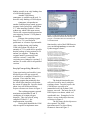
Figure 1. This figure shows the dependent ESRI
libraries required to calculate the envelope of a
polygon. Screenshot taken from the Microsoft
Visual Basic IDE.
functionality, each of the ESRI libraries
were run through makepy to create the
Python wrapper classes:
D:\arcgis\python23\Lib\sitepackages\win32com\client>makepy.py
Generating to D:\arcgis\python23\lib\sitepackages\win32com\gen_py\2396BA16-B4C6
-4D51-86E7-B4667206E86Fx0x1x0.py
D:\arcgis\python23\Lib\sitepackages\win32com\client>makepy.py
Generating to D:\arcgis\python23\lib\sitepackages\win32com\gen_py\ADC7DE29-DC0B
-448E-BBF6-27E4E34CF2ECx0x1x0.py
D:\arcgis\python23\Lib\sitepackages\win32com\client>makepy.py
Generating to D:\arcgis\python23\lib\sitepackages\win32com\gen_py\1CE6AC65-43F5
-4529-8FC0-D7ED298E4F1Ax0x1x0.py
Proof of Concept Using VB and C++
D:\arcgis\python23\Lib\sitepackages\win32com\client>makepy.py
Generating to D:\arcgis\python23\lib\sitepackages\win32com\gen_py\0475BDB1-E5B2
-4CA2-9127-B4B1683E70C2x0x1x0.py
Upon experiencing such trouble, it was
decided to prove the get extent call
would work as a compiled VB and C++
program. First, make the ienv
example program that minimally does
the IEnvelope interface to determine
the extent of a shapefile. Specific details
about ienv will be discussed later.
Project references are shown in Figure 1.
The resulting programs reported
maximum and minimum X and Y
coordinates of an input polygon
shapefile. They also proved, using
compiled VB and C++, the
implementation is possible.
Having thus identified the COM
objects required to implement some
D:\arcgis\python23\Lib\sitepackages\win32com\client>makepy.py
Generating to D:\arcgis\python23\lib\sitepackages\win32com\gen_py\C4B094C2-FF32
-4FA1-ABCB-7820F8D6FB68x0x1x0.py
The desired functionality was
still out of reach by merely using the
resulting classes. In order to prove the
COM objects were able to be
instantiated at all, the Python COM
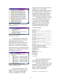
browser was used. The entire list of all
ESRI objects was shown, which is of
considerable size. Examples of a few
objects, as seen in the object browser,
are shown in Figure 2.
The file names for the objects are
also reported. The ESRI
DataSourcesFile object library
filename is shown in Figure 3.
5
program ran, many files appeared in the
<python dir>\Lib\sitepackages\comtypes\gen folder that
were not there before. Such behavior
suggests that using the object browser or
an application could instantiate and
possibly internally makepy the objects.
To further prove it is the case, all
the objects from the <python dir>\
Lib\site-packages\comtypes
\gen folder were deleted and the
program was rerun. It generated the
following output instead, which is
promising, but also showed some
unexpected output:
Figure 2. This figure shows an example of the
Python Object Browser.
C:\temp\model>ienv.py
getmodule
# Generating
comtypes.gen._1CE6AC65_43F5_4529_8FC0_D7ED298E4F1A_0_1
_0
# Generating
comtypes.gen._00020430_0000_0000_C000_000000000046_0_2
_0
# Generating comtypes.gen.stdole
# Generating
comtypes.gen._0475BDB1_E5B2_4CA2_9127_B4B1683E70C2_0_1
_0
# Generating
comtypes.gen._5E1F7BC3_67C5_4AEE_8EC6_C4B73AAC42ED_0_1
_0
# Generating comtypes.gen.esriSystem
# Generating
comtypes.gen._C4B094C2_FF32_4FA1_ABCB_7820F8D6FB68_0_1
_0
# Generating comtypes.gen.esriGeometry
# Generating
comtypes.gen._59FCCD31_434C_4017_BDEF_DB4B7EDC9CE0_0_1
_0
# Generating
comtypes.gen._4ECCA6E2_B16B_4ACA_BD17_E74CAE4C150A_0_1
_0
# Generating comtypes.gen.esriSystemUI
# Generating comtypes.gen.esriDisplay
# Generating comtypes.gen.esriGeoDatabase
# Generating comtypes.gen.esriDataSourcesFile
done getmodule
do import wkspfact
done import wkspfact
inst obj
done inst obj
Check out spatial extension
done check out
add toolbox
done add toolbox
start dogserver
done dogserver
start shapefile
Figure 3. A fully qualified file name shown in
the Python Object Browser.
Some properties of some of the
objects examined in the object browser
presented error messages. An
application that uses the methods in the
object shown in Figure 4 may not be
able to do so using Python. Perhaps the
errors shown here are a problem with the
object browser, and not a shortcoming of
the language specification.
C:\temp\model>
Upon observing the gen folder,
all of the deleted .py files were regenerated, along with many more.
The next experiment was to call a
method that creates a typed return value,
and call a method from that returned
object. In short, implement the
following VB code in Python:
Figure 4. Example type library showing errors
in the Python Object Browser.
In later experimentation, a test
program used the esricatalog.olb
module. This approach allowed the
object to be instantiated. After the
Dim pWsFact As IWorkspaceFactory
6
Set pWsFact =
CreateObject("esriDataSourcesFile.
ShapefileWorkspaceFactory.1")
could be a possible explanation why this
coclass is never used explicitly.
The only way the coclass was
revealed was to write the target program
in another language, run regmon to see
what COM objects it is using. Only then
could the correct COM object be
identified and used in the Python code.
It seems excessive that such an effort is
required to create an app in Python: first
create a test app in another language.
Next experiment: After
successful instantiation of pWsFact =
Dim pws As IWorkspace
Set pws = pWsFact.OpenFromFile("d:\bb",
0)
Step 1 was accomplished in
previous experiments: create an
IWorkspaceFactory. The earlier
example [ienv.py] did just
CreateObject. The next step is to call
QueryInterface on IWorkspace
Factory, and get an IWorkspace, and
from that call the method
OpenFromFile. OpenFromFile is
shown in Figure 5 in the object browser.
createobj (shapefilework
spacefactory), call QueryInter
face to transform it into an IWork
spaceFactory. Here is an example of
the generated files:
_1CE6AC65_43F5_4529_8FC0_D7ED298E4F1A_0_1_0.py.txt:554
:ShapefileWorkspaceFactory._com_interfaces_ =
[comtypes.gen._00020430_0000_0000_C000_000000000046_0_
2_0.IUnknown,
comtypes.gen._0475BDB1_E5B2_4CA2_9127_B4B1683E70C2_0_1
_0.IWorkspaceFactory,
comtypes.gen._0475BDB1_E5B2_4CA2_9127_B4B1683E70C2_0_1
_0.IWorkspaceFactory2]
Within the generated files, the
section shown here defines the
workspace factory:
Figure 5. IWorkspaceFactory interface shown in
the Python Object Browser.
class ShapefileWorkspaceFactory(CoClass):
u'ESRI Shapefile Workspace Factory.'
_reg_clsid_ = GUID('{A06ADB96-D95C-11D1-AA8100C04FA33A15}')
_idlflags_ = []
_reg_typelib_ = ('{1CE6AC65-43F5-4529-8FC0D7ED298E4F1A}', 1, 0)
ShapefileWorkspaceFactory._com_interfaces_ =
[comtypes.gen._00020430_0000_0000_C000_000000000046_0_
2_0.IUnknown,
comtypes.gen._0475BDB1_E5B2_4CA2_9127_B4B1683E70C2_0_1
_0.IWorkspaceFactory,
comtypes.gen._0475BDB1_E5B2_4CA2_9127_B4B1683E70C2_0_1
_0.IWorkspaceFactory2]
The only successful way to
determine the coclass that was used by
OpenFromFile was to run the compiled
VB application [ienv.exe] while
concurrently running regmon. It
showed that the app looked up a coclass
named esriGeoDatabase.
AggregateDatasetEnumImpl. The
above code sample, which is the
successful code, instantiates
IWorkspace. Nowhere is
AggregateDatasetEnumImpl shown.
A web search of that coclass name
turned up only one example, which did
not do a CreateInstance of that
coclass. In addition, the coclass is not
documented anywhere in the ESRI
website. The definition of aggregation
Here is the final implementation
in the Python code:
pWsFact =
comtypes.client.CreateObject("esriDataSourcesFile.
ShapefileWorkspaceFactory")
o1 = pWsFact.QueryInterface(comtypes.IUnknown)
o2 =
o1.QueryInterface(comtypes.gen._0475BDB1_E5B2_4CA2_912
7_B4B1683E70C
2_0_1_0.IWorkspaceFactory)
print "now open files"
pws = o2.OpenFromFile("c:\\temp\\model",0)
print "done open files"
It can be seen that o2 is of the
proper interface type to call the
7
OpenFromFile method. This is the
problems identified are still valid
problems regardless of the experience of
the developer.
desired COM object:
IWorkspace._methods_ = [
COMMETHOD(['propget', helpstring(u'The connection
properties of the workspace.')], HRESULT,
'ConnectionProperties',
( ['retval', 'out'],
POINTER(POINTER(comtypes.gen._5E1F7BC3_67C5_4AEE_8EC6_
C4B73AAC42ED_0_1_0.IPropertySet)),
'ConnectionProperties' )),
COMMETHOD(['propget', helpstring(u'The factory
that created the workspace.')], HRESULT,
'WorkspaceFactory',
( ['retval', 'out'],
POINTER(POINTER(IWorkspaceFactory)), 'Factory' )),
COMMETHOD(['propget', helpstring(u'The datasets in
the workspace.')], HRESULT, 'Datasets',
( ['in'], esriDatasetType, 'DatasetType'
),
( ['retval', 'out'],
POINTER(POINTER(IEnumDataset)), 'Datasets' )),
COMMETHOD(['propget', helpstring(u'The
DatasetNames in the workspace.')], HRESULT,
'DatasetNames',
( ['in'], esriDatasetType, 'DatasetType'
),
( ['retval', 'out'],
POINTER(POINTER(IEnumDatasetName)), 'DatasetNames' )),
COMMETHOD(['propget', helpstring(u'The file system
full path of the workspace.')], HRESULT, 'PathName',
( ['retval', 'out'], POINTER(BSTR),
'PathName' )),
COMMETHOD(['propget', helpstring(u'The Type of the
Workspace.')], HRESULT, 'Type',
( ['retval', 'out'],
POINTER(esriWorkspaceType), 'Type' )),
COMMETHOD([helpstring(u'TRUE if the workspace is a
file system directory.')], HRESULT, 'IsDirectory',
( ['retval', 'out'],
POINTER(VARIANT_BOOL), 'isDir' )),
COMMETHOD([helpstring(u'Checks if the workspace
exists.')], HRESULT, 'Exists',
( ['retval', 'out'],
POINTER(VARIANT_BOOL), 'Exists' )),
COMMETHOD([helpstring(u'Executes the specified SQL
statement.')], HRESULT, 'ExecuteSQL',
( ['in'], BSTR, 'sqlStmt' )),]
Compiled VB and C++ Restated
In the process of trying to use Python,
portions of the code were successfully
written in compiled VB and C++. It is
therefore possible to implement the code
in the compiled languages. This
statement is important: C++ can
implement any functionality, especially
COM implementations. Compiled VB
code is syntactically identical to the
VBA code written within ArcMap, and
therefore is equally able to implement
the desired functionality. There was no
need to prove these two languages were
viable by completely implementing the
solution demonstrated in VBA. Small
programs that demonstrated various
parts of the complete solution, along
with the whole solution within ArcMap,
were sufficient.
After weeks of experimentation,
the integrity of the Python development
environment began to decay. When
running pythonwin, Windows Explorer
and Notepad freeze and become
unusable until pythonwin is exited.
Python documentation states
CoUnInitialize is not working
correctly, and experience confirms it.
About 30 seconds after the script
completes execution, Windows presents
an error message.
Such behavior raised suspicion
that critical Python system files were
corrupt, so Python was completely
uninstalled and re-installed. It
unfortunately still showed the same
undesirable behavior after reinstalling
Python.
It is entirely possible that the
author’s inexperience with Python
caused some of the observed behavior,
but it is evident that many of the
Implement the Tool in C# .NET
ESRI provides a wealth of documentation and code samples from both ESRI
documentation and from the user
community in the ESRI user forums. As
stated in the introduction, the VBA
implementation of ArcObjects is mature
and well documented, and the number of
C# code samples is steadily increasing.
Therefore, it was relatively easy
to continue the development paradigm
using C#: find C# samples on the web,
modify the samples to incorporate the
desired functionality, and repeat.
The resulting application was
completely command line driven; a
command line program, using
parameters such as shapefile name,
distance between points, and output
8
shapefile name, can be typed from the
command line or invoked from
ArcToolbox.
Because not all languages were able to
deliver the final product, only VBA and
C# will be discussed.
Most development is an iterative
process of “find an example,” “modify
the example to more closely match end
result,” and repeat.
It may not be a fair comparison
to redo the same exact application in all
languages to see which one is easier to
develop. Lessons learned in writing the
program in one language can be
exploited in the other languages. Each
language should be used to write a
different end product, of comparable
complexity, in order to eliminate such
learning experiences. There is also the
unfair advantage of a language the
developer has more experience in.
All in all, the development time
of VBA and C# were fairly equal. Part
of the development time was learning
the ArcObjects object model. The
ArcObjects model is much larger and
more complex than many developers
encounter.
Results
Original expectations were that all
languages would be equal and an
organization could choose to use any
language that best suited its IT staff.
However, the manual stated that
VB script was unable to support early
binding COM objects. If a homogenous
VB script solution is strongly desired, an
IDispatch wrapper/shell for the required
COM objects of the application at hand
could be created. The drawback of this
solution is that any future updates to the
underlying objects could break the
wrapper and need to be updated
accordingly.
Python was also disqualified. It
was better than VBScript in that it
supports early binding COM objects, but
not without problems, and some of the
objects were not able to be supported
(Figure 4). There was also the question
of ctypes’s availability only in Python
2.3.
VBA, integrated into ArcMap,
was able to deliver all functionality
without problem. Additionally,
compiled VB and C++ demonstrated
their abilities to support the
functionality. C#, which implements the
.NET language specification, was able to
deliver the desired functionality.
Because all .NET languages support the
common language specification, all
.NET languages may be considered
identical and are thus able to deliver the
desired functionality.
Execution Time
After the languages VBA and C# had
been proven as viable languages, their
execution times were compared.
The first test was conducted on
the original computer the applications
were developed on: an HP Pavilion
dv5000 with an AMD Turion 64 bit 1.8
GHz with 1 GB RAM, running 32 bit
Windows XP Professional.
The VBA application performed
acceptably, taking less than a minute to
create approximately 500 points and 200
hexagons over an area of 250,000 square
miles. In comparison, the C# application
took 37 times longer to perform the
exact same thing.
Development Time
9
This prompted a careful analysis
of the source code, which revealed little
room for improvement. The only
questionable code, which followed the
ESRI example of efficient creation of
polygons, did the following within a
function that was called repeatedly; once
for each hexagon:
IPoint
IPoint
IPoint
IPoint
IPoint
IPoint
IPoint
pPointsRing0
pPointsRing1
pPointsRing2
pPointsRing3
pPointsRing4
pPointsRing5
pPointsRing6
=
=
=
=
=
=
=
new
new
new
new
new
new
new
Additionally, the applications
were compared on operating systems
running on Microsoft Virtual PC and
Microsoft Virtual Server 2003.
Experiments shown on the bar graphs
are designated as running physical or
virtual.
Knowing these facts about the
experiments and environments, the
names of the experiments on the graphs
may be interpreted as follows:
PointClass();
PointClass();
PointClass();
PointClass();
PointClass();
PointClass();
PointClass();
1) VB physical: VBA app run on
physical computer.
2) VB virtual: VBA app run on virtual
image, run on that physical computer.
3) C# physical: C# app, default
threading model, run on physical
computer.
4) STA physical: C# app, explicitly
coded to use STA threading model, run
on physical computer.
5) STA virtual: C# app, explicitly coded
to use STA threading model, run on
virtual image, run on that physical
computer.
6) MTA physical: C# app, explicitly
coded to use MTA threading model, run
on physical computer.
7) MTA virtual: C# app, explicitly coded
to use MTA threading model, run on
virtual image, run on that physical
computer.
ESRI code samples provided
with the ArcGIS install were described
as the most efficient way to create
polygons. Perhaps, in the case of this
application, where many polygons were
created, it is not the most efficient
method. It may be efficient for the
creation of a single polygon.
The code was changed to declare
and instantiate the PointClass objects
once, outside the function, as member
variables to avoid duplicate
construction/destruction. This
modification improved the performance
by 4 minutes. Figure 6 shows the
improvement between “C# physical 1”
and “STA physical.”
Additional analysis of COM
performance prompted comparison
between apartment threading models to
eliminate marshalling overhead. Again,
Appendix A of the developer guide
provides more information on COM,
briefly outlining the meaning of
apartment threading models (ESRI,
2004).
All subsequent experiments
compare the performance of the C#
application using both threading models.
Experiments shown on the bar graphs
are designated as running the STA or
MTA threading models.
The virtual system running on
the HP dv5000 computer is Microsoft
Virtual PC, running Microsoft XP
Professional, using 660 MB RAM.
To prove the performance issues
are not an anomaly of a single machine,
the same application was installed and
run on other computers.
The next experimental machine
was a newly built Dell Dimension 4400
with a Pentium 4 1.33 GHz with 750
MB RAM, running Windows XP
10
Computer time was acquired on
an instance of Microsoft Windows
Server 2003 Enterprise Edition, running
on Microsoft Virtual Server 2003 at 1.33
GHz and 1.95 GB RAM, on a Dell 2950
host with dual Intel Xeon 5150
processors at 2.66 GHz with 16 GB
RAM running Microsoft Server 2003 R2
Enterprise x64 Edition. Figure 8 shows
the results on this virtual machine.
It was observed that the
applications run consistently faster on
the virtual machines.
It was observed that memory
usage was low and the majority of delay
in the C# app was because it was I/O
bound, repeatedly accessing the registry.
While running the slow C# app,
regmon results were monitored. It could
be seen that the app was continually recreating a COM object because it
repeatedly got the same registry key in
HKEY_CLASSES_ROOT.
Professional. The OS was installed from
scratch, ArcGIS 9.1 was installed, and
the application was copied to the
computer and run. This clean install
removes any risk of system corruption
from continued development, installation
HP dv5000
785
MTA virtual
649
Experiment
STA virtual
32
VB virtual
787.266
MTA physical
759.61
STA physical
1009.109
C# physical 1
27
VB physical
0
500
1000
1500
Seconds
Figure 6. HP dv5000 experimental results.
and uninstallation of various products.
All subsequent experiments were
completed in this way: clean install of
Windows, ArcGIS, and the application.
The virtual computer running on
this system is Microsoft Virtual PC
running an instance of Microsoft XP
Professional with 555 MB RAM.
Results of this machine are
outlined in Figure 7.
Dell 2950
27.104
Experiment
MTA virtual
24.794
STA virtual
33
C# virtual
19
VB virtual
0
Dell 4400
20
30
40
Seconds
MTA virtual
Experiment
10
Figure 8. Dell 2950 experimental results.
434
STA virtual
389
C# virtual
This behavior draws the
conclusion that the .NET classes are just
COM interop wrapper classes. They are
not doing anything more than adding
extra overhead, as the following pseudo
code outlines:
457
VB virtual
10
C# physical
416
VB physical
12
0
100
200
300
400
500
Seconds
Figure 7. Dell 4400 experimental results.
Create instance of class
Call class method
11
slow, in time ESRI will rewrite them in
pure C# and vastly improve their
performance.
Class creates COM object
Class calls COM object
Class releases COM object
Class goes out of scope; it is destructed.
COM interop
ESRI’s ArcObjects is the single
most extensive COM object model in the
world. ESRI cannot “simply” rewrite
everything overnight. They can,
however, create several thousand
wrapper classes with one line of code:
Experiment
catcaller
1.39
cscaller
8.359
caller
1.484
0
for %i in (*.olb) do tlbimp %i
/out:%i.dnet.olb
2
4
6
8
10
Seconds
Figure 9. COM interop experimental results.
In time, ESRI will rewrite all
objects in pure C#. The COM interop
overhead will then be eliminated.
To demonstrate, a simple COM
object [dogserver], that appends a
single line containing date and time to a
text file, was written in C++, and called
with a C++ caller.
Afterwards, a COM interop
wrapper was created with tlbimp as
demonstrated above, and called from a
C# caller. It was understandably slower
because of the added overhead of the
wrapper class created by tlbimp.
Next a pure C# implementation
[catserver], which also appends date
and time to a text file, saved as a callable
C# class in a DLL assembly, was called
from a C# caller. It turned out to be
faster than the original COM program
written in C++.
Figure 9 shows the results.
Caller is the C++ program that calls
dogserver. CSCaller is a C#
program that calls dogserver using
COM interop. Catcaller is the C#
program that calls catserver. All three
programs call the method to write to the
text file 5000 times.
This gives strong evidence that
although code written with today’s C#
class wrappers to ArcObjects may run
Hopefully in the interim, ESRI
will rewrite the most heavily used COM
objects first, so the benefits demonstated here can be reaped as soon as
possible.
Discussion
It was proven that some languages are
unable to deliver complete functionality.
It was also found that the development
time was roughly equal.
The reason for this research topic
was such that many organizations are
faced with maintaining an obsolete, unsupported product. They must move
forward to a more current technology.
The agonizing question: which language
is best for the future of the organization?
With development time,
maintainability, online support, and
industry acceptance of VB, VBA, C++,
VB.NET, and C# being equal, it appears
that the longevity of the chosen language
should be the deciding factor.
Microsoft has announced the transition
of Visual Studio 6 (VB, C++) from full
support to end of lifetime support
(Microsoft, 2006). Microsoft is also
strongly recommending that
organizations migrate their code to the
new languages that support .NET. ESRI
12
and Microsoft both show examples of
web services, VB.NET, and C# to
leverage the latest languages.
Knowing this, it is quite evident
that programs written in the more recent
languages, such as Visual Basic 6, will
soon need to be migrated to the newer
.NET compliant languages.
Therefore, the strategic solution
would be migration of Avenue directly
to .NET if possible, and thus prevent
another costly round of refactoring.
Some organizations convert their code in
a reactionary way with little thought to
consider the future. This study has
shown what languages are viable, and
provides evidence to help make a
prudent choice regarding the future.
Applications needing quick
response time may need to be written in
VBA in the interim until ESRI
completes its C# rewrite of all
ArcObjects.
Environmental Systems Research
Institute, Inc., Welcome to ArcObjects
Online, Retrieved June 2006 from
http://edndoc.esri.com/arcobjects/8.3/d
efault.asp.
Hammond, M. and Robinson, A. 2000.
Python Programming on Win32,
O’Reilly & Associates, Sebastopol,
CA.
Marble, D. F. 2005. Defining the
Components of the Geospatial
Workforce – Who Are We? Arc News
Vol. 27 No. 4, 1.
Microsoft Corporation, Microsoft
Support Lifecycle, Retrieved June 2006
from http://support.microsoft.com
/lifecycle/?LN=en-us&p1=3003&
x=15&y=10.
Minnesota DNR. 2005. DNR Sampling
Tool (V2.8 Nov 09,2005), Minnesota
DNR, Saint Paul, MN.
Acknowledgments
I would like to thank Tim Loesch of the
Minnesota DNR and the Resource
Analysis staff at Saint Mary’s University
of Minnesota for their help during this
project.
References
Environmental Systems Research
Institute, Inc. 2004. ArcGIS Desktop
Developer Guide, 139, Online manual
provided with install of ArcGIS 9
software.
Environmental Systems Research
Institute, Inc., Product Lifecycle
Support Policy: ArcView GIS (3.3),
Retrieved June 2006 from
http://downloads.esri.com/support/pro
duct%20life%20cycle/other_/589arcvi
ewgis.pdf.
13