1
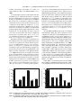
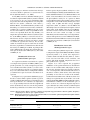
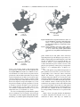
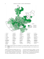
REGIONES TÉRMICAS ÓPTIMAS Y MARGINALES PARA EL CULTIVO
DE Agave tequilana EN EL ESTADO DE JALISCO
OPTIMAL AND MARGINAL THERMAL REGIONS FOR THE CULTIVATION
OF Agave tequilana ON THE JALISCO STATE
José A. Ruiz-Corral1, Eulogio Pimienta-Barrios2 y Julia Zañudo-Hernández2
1
Instituto Nacional de Investigaciones Forestales y Agropecuarias. CIRPAC. Parque Los Colomos.
Guadalajara, Jalisco. 2Departamento de Ecología. CUCBA-Universidad de Guadalajara. Km 15.5 Carretera Guadalajara-Nogales. 45110. Las Agujas, Nextipac, Zapopan, Jalisco. Tel. y Fax: 36-820-076.
([email protected])
RESUMEN
ABSTRACT
El agave azul (Agave tequilana Weber) se ha convertido en un cultivo importante en el Estado de Jalisco, México, debido al incremento en la demanda de tequila. Sin embargo, la superficie cultivada ha disminuido durante los últimos cuatro años, debido al
daño causado por plagas y enfermedades. Recientemente se han
establecido nuevas plantaciones en diferentes localidades de Jalisco, algunas de las cuales presentan condiciones climáticas diferentes de las regiones tradicionales del cultivo. Con el fin de contribuir a ordenar la planificación del cultivo de A. tequilana, se realizó un estudio de la respuesta fotosintética estacional en plantaciones ubicadas en Amatitán y en Arandas, Jalisco, ubicadas en las
regiones más importantes de cultivo de A. tequilana. Las localidades experimentales presentan diferencias en la temperatura promedio anual, debido a que Amatitán y Arandas se localizan a 1000
y 2000 m de altura. La fotosíntesis se incrementó por temperaturas promedio frescas diurnas (22-25 oC) y nocturnas (14-16 oC),
pero disminuyó por temperaturas promedio cálidas durante el día
(>28 oC) y la noche (>20 oC). La respuesta de la fotosíntesis a la
temperatura se empleó para definir intervalos térmicos de estratificación, que incluyen promedios anuales de temperatura nocturna y diurna. También se determinó la probabilidad de ocurrencia
de temperaturas menores o iguales a −7 oC en Jalisco. Con estos
intervalos se identificaron áreas donde se reducen los riesgos causados por bajas temperaturas y áreas favorables para la actividad
fotosintética en A. tequilana. Con esta información se elaboró un
mapa de Jalisco en el cual se localizan las áreas térmicas optimas
y marginales para el cultivo de A. tequilana. Las áreas óptimas
están en el norte, noreste y la parte central de Jalisco; las marginales, en la región denominada Los Altos, las planicies costeras y
en cañones y barrancas del Estado.
Because of the increase of the demand for the beverage known as
tequila, agave azul (Agave tequilana Weber) has become an
important crop for the State of Jalisco. Notwithstanding this
demand, cultivation areas have been reduced during the last four
years, because of the damage caused by pests and diseases. Recently,
new plantations have been established in different localities of
Jalisco. Some of these new localities, however, have climatic
conditions that differ from the traditional sites of cultivation. With
the purpose of directing the future cultivation of Agave tequilana,
an examination of the photosynthetic response to seasonal changes
was realized in plantations in Amatitán and Arandas, Jalisco. These
plantations are located in two of the most important cultivation
regions for A. tequilana. The Amatitán and Arandas plantations
have different average annual temperatures, since they are located
at altitudes of 1000 m and 2000 m. Photosynthesis increased with
fresh average diurnal temperatures (22-25 oC) and fresh night
temperatures (14-16 oC), but decreased with warm temperatures
during the day (>28 oC) and night (>20 oC). Photosynthetic response
to temperature was used to define the thermal stratification ranges
that include average annual nocturnal and diurnal temperature.
The probability of temperatures less or equal than −7 oC occurring
in Jalisco was also determined. Thermal ranges were used to
identify regions with reduced risks caused by low temperatures,
and regions with temperatures favorable for photosynthesis for A.
tequilana. A map of Jalisco was developed, in which the optimal
and marginal areas for the cultivation of A. tequilana were
identified. The optimal thermal areas for the cultivation of A.
tequilana are located in the north, northeast and central parts of
Jalisco, the marginal areas in the region called Los Altos, the coastal
plains, and inland canyons.
Palabras clave: Agave tequilana, fotosíntesis, temperatura, regiones
de cultivo.
Key words: Agave tequilana, photosynthesis, temperature, cultivation
regions.
INTRODUCTION
A
gave azul (Agave tequilana Weber) has become
an important crop for the State of Jalisco since
1995, because of the increased demand for
Recibido: Marzo, 2001. Aprobado: Enero, 2002.
Publicado como ARTÍCULO en Agrociencia 36: 41-53. 2002.
41
AGROCIENCIA VOLUMEN 36, NÚMERO 1, ENERO-FEBRERO 2002
42
INTRODUCCIÓN
E
l agave azul (Agave tequilana Weber) es un cultivo importante en Jalisco desde 1995 debido a la
creciente demanda de tequila que se derivó de la
denominación de origen al tequila acompañada por la certificación de calidad, la promoción en los mercados internacionales por el Consejo Regulador del Tequila (CRT)
y la proliferación de nuevas empresas. Este incremento
en la demanda del tequila fue paralelo a la disminución
en la superficie cultivada del agave: de 1990 a 1997 la
superficie aumentó de 50 000 a 62 000 ha, pero después
de 1997 se redujo en 26.5% y en 2000 a 45 000 ha. Esta
disminución se atribuye a diferentes causas: el bajo precio de las piñas durante 1996-1998 (CRT, 2000); los daños causados por el picudo del agave Scyphophorus
acupunctatus Gyllenhal, el piojo harinoso Pseudococcus
sp., el gusano blanco Acentrocneme (Aegiale) hesperiaris
(Wlk.), la marchitez causada por Fusarium oxysporum;
y la pudrición del cogollo causada por Erwinia sp. (Flores, 2000). El CRT considera que para satisfacer la demanda actual es necesario incrementar la superficie de
cultivo a 100 000 ha.
Por tanto, hay interés por establecer nuevas plantaciones; algunas se han situado en las zonas tradicionales
de cultivo, pero otras se ubicaron en nuevos ambientes
más cálidos o más fríos que aquellas regiones. La temperatura puede influir en los procesos fisiológicos básicos,
como fotosíntesis y respiración, que determinan en gran
parte la cantidad de los azúcares que se forman en las
hojas y posteriormente se transportan y almacenan en la
piña. Trabajos previos en especies que presentan el metabolismo del ácido crasuláceo (MAC), como en A.
tequilana, Opuntia ficus-indica y Stenocereus
queretaronesis, han revelado que temperaturas cálidas
reducen la fotosíntesis e incrementan la respiración (Nobel
et al., 1998; Pimienta-Barrios et al., 2000). También se
ha encontrado que A. tequilana es una planta sensible al
daño por temperaturas bajas (−7 oC) (Nobel et al., 1998).
Este trabajo tuvo como objetivo delimitar las áreas
térmicas óptimas y marginales para el cultivo de A.
tequilana, usando información climática de las principales regiones de Jalisco y la respuesta fisiológica de esta
planta a la temperatura, luz y humedad del suelo obtenida a través de estudios ecofisiológicos en plantaciones
ubicadas en las principales regiones productoras de A.
tequilana en Jalisco.
tequila, brought about by the official recognition of the
origin of tequila and the certification of quality, and,
furthermore, its promotion on international markets by
the Consejo Regulador del Tequila (CRT), and the
proliferation of new companies producing the beverage.
However, the increased demand of tequila was
accompanied by a drastic reduction in the area dedicated
to agave cultivation. For example, from 1990 to 1997 the
cultivated land increased from 50 000 to 62 000 ha. After
1997, it was reduced by 26.5%, and in the year 2000, to
45 000 ha. This reduction resulted from different causes:
The low price of boles from 1996 to 1998 (CRT, 2000);
the damage caused by pests and diseases such as agave
weevil Scyphophorus acupunctatus Gyllenhal, powdery
louse Pseudococcus sp., white worm Acentrocneme
(Aegiale) hesperiaris (Wlk.), wilting caused by
Fusarium oxysporum; and the heart rot caused by
Erwinia sp. (Flores, 2000). CRT predictions consider
that the cultivated land of A. tequilana should increase
to 100 000 ha in order to satisfy the present industrial
demand. Therefore, there is an increasing interest in
establishing new plantations. Some of them have been
located in the traditional cultivation zones, while others
have been established in warmer or cooler environments
than the traditional ones. The differences in temperature
prevailing in the new cultivation areas, might affect basic
physiological processes such as photosynthesis and
respiration, which greatly determine the amount of
sugars produced by the leaves and are latter transported
to the crown, where sugars are stored. Previous works
on succulent plants, that present crassulacean acid
metabolism (CAM), as A. tequilana, Opuntia ficusindica and Stenocereus queretaronensis, revealed that
high temperatures reduce photosynthesis and increase
respiration (Nobel et al., 1998; Pimienta-Barrios et al.,
2000). It also was found that A. tequilana is a plant
susceptible to low temperature damages (−7 oC) (Nobel
et al., 1998).
The main objective of this study was to delimit the
optimal, sub-optimal, and marginal thermal areas for the
cultivation of A. tequilana by using climatic information
obtained from the main regions of the state of Jalisco,
and the physiological response of this plant to
temperature, light and soil humidity, obtained through
eco-physiological studies conducted in the most important
producing regions in Jalisco.
MATERIALS AND METHODS
MATERIALES Y MÉTODOS
Climatic description of the agave production areas
Descripción climática de las áreas productoras de agave
Las zonas productoras de A. tequilana más importantes están en
las regiones de Los Altos, Zona Centro y Tequila. La región de Los
The most important cultivation areas of A. tequilana are located
in the geographic regions named Los Altos, Central zone and Tequila.
Los Altos region has an altitude that varies from 1900 to 2350 m. The
RUIZ-CORRAL et al.: REGIONES TÉRMICAS PARA EL CULTIVO DE AGAVE
43
Altos se encuentra a una altitud que varía de 1900 a 2350 m; la temperatura promedio anual nocturna oscila entre 9 y 17 oC y la diurna entre
21 y 27 oC, y la precipitación pluvial varía de 705 a 870 mm (INEGI,
1992; Medina et al., 1998). En la región Centro se encuentra el municipio de Amatitán, el único importante en la producción de agave azul,
el cual está conectado con la región de Tequila formando prácticamente una sola zona. El clima en estas regiones es similar y más cálido que
en la región de Los Altos; presenta una mayor variación de altitud (470
a 2830 m) la cual se refleja en mayores variaciones térmicas, ya que la
temperatura promedio anual nocturna va de 11 a 22 oC, con una media
de 17 oC, y una diurna de 22 a 32 oC con un promedio de 27 oC. La
precipitación acumulada anual varía de 830 a 1050 mm (INEGI, 1992;
Medina et al., 1998).
mean annual night temperature oscillates between 9 and 17 oC, while
the average annual day temperature ranges from 21 to 27 oC. Rainfall
varies from 705 to 870 mm (INEGI, 1992; Medina et al., 1998).
Amatitán is located in the Central region, and is the only important
cultivation area of agave in this region. It is physically connected to
the Tequila region forming practically one single zone of cultivation.
The climate in the Central and the Tequila regions is similar to, or
warmer, than that in Los Altos, and presents greater variation of
altitude (470 to 2830 m, which brings about greater thermal
variations. Average night temperatures vary between 11 and 22 oC,
with an average of 17 oC; during the day, temperatures, oscillate
from 22 to 32 oC, with a an average of 27 oC. The accumulated rainfall
varies from 830 to 1050 mm (INEGI, 1992; Medina et al., 1998).
Estudio ecofisiológico
Ecophysiological study
Este estudio se llevó a cabo desde septiembre de 1998 hasta agosto de 1999, en dos plantaciones comerciales de agave azul (Agave
tequilana Weber var. azul) en Jalisco, México. La primera se localiza
en Amatitán (AMAJ) a 20o 42’ 30” N, 103o 37’40” O y 1310 m, con
clima subtropical cálido (Medina et al., 1998), y la segunda en Arandas
(ARAJ) a 20o 36’ 30” N, 102o 00’45” O y 2000 m, con clima subtropical
templado (Medina et al., 1998). En cada plantación se seleccionó un
bloque de 50 plantas de cinco años, y en cada fecha de medición se
eligieron al azar 10 plantas de esta población para medir asimilación
neta de CO2 cada 2 h durante 24 h. Se llevaron a cabo seis mediciones
de fotosíntesis en cada plantación (septiembre, 1998; noviembre, 1998;
enero, 1999; marzo, 1999; junio, 1999; y agosto 1999). Se empleó un
aparato portátil para medir fotosíntesis Li-Cor LI-6200 (Li-Cor Lincoln,
NE, EE.UU), cuya cámara de medición de 250 cm3 fue modificada
para registrar el intercambio de gases en una superficie laminar suculenta, como es el caso de las hojas de A. tequilana. Esta modificación
requirió el reemplazo de la cubierta semicilíndrica, dejando la parte
de la cámara en forma de prisma con base rectangular, la que fue cubierta con una mica de plástico, dejando en un extremo una pequeña
abertura rectangular de 6 cm2 (2 cm x 3 cm) cuyos bordes se cubrieron
con hule-espuma (Pimienta-Barrios et al., 2000). Esta apertura se puso
en contacto con la epidermis superior de la parte media de la hoja de
A. tequilana para registrar el intercambio de CO2 entre la hoja y el
aire. En cada periodo de medición se usó una hoja por planta elegida
al azar. Los valores de asimilación neta diaria de CO2 se obtuvieron
integrando las tasas instantáneas de asimilación en 24 h.
En cada fecha de medición se registró cada hora el flujo
fotosintético de fotones (FFF; longitudes de onda de 400-700 nm),
desde la salida hasta la puesta del sol, con un sensor cuántico Li-Cor
190S (Li-Cor, Lincoln, NE, EE.UU). También se registró cada hora
la temperatura del aire durante 24 h, con un termómetro de mercurio. Para determinar el contenido de agua en el suelo, cada dos meses (septiembre de 1998 a agosto de 1999) se colectaron 10 muestras
de suelo en las zonas donde se encontraban las raíces (rizosfera) de
las plantas de agave azul, a una profundidad de 20 cm, en un radio
no mayor a 1 m a partir de la base de la planta. Estas muestras fueron
colocadas en una estufa y secadas a 80 oC por 72 h hasta que no se
registraron cambios posteriores en peso. Los datos se expresaron
This study was conducted from September 1998 to August 1999,
at two commercial plantations of agave azul (Agave tequilana Weber
var. azul) in Jalisco, México. One plantation was located in Amatitán
(AMAJ) at 20o 42’ 30” N, 103o 37’ 40” W, and 1310 m, which is
technically classified as a zone of warm subtropical climate (Medina
et al., 1998). The other plantation was located in Arandas (ARAJ) at
20o 36’30” N, 102o 00’ 45” W, and 2000 m, having a temperate
subtropical climate (Medina et al., 1998). In each plantation, a plot of
50 five year-old plants was selected. On each measurement date, 10
plants were randomly chosen of each plot for the determinations of
net CO2 uptake every two h, over a 24-h period. Six photosynthetic
measurements were made in each plantation (September 1998;
November 1998; January 1999; March 1999; June 1999; and August
1999). A Li-Cor LI-6200 (Li-Cor, Lincoln, NE, EEUU) portable
photosynthetic device was used to measure photosynthesis, whose leaf
chamber (250 cm3) was modified to facilitate gas exchange
measurements in the laminar succulent leaves of A. tequilana. This
modification required the replacement of the semicilindric cover,
leaving the part of the chamber resembling a prism with rectangular
base, that was covered with a plastic mica, allowing a small rectangular
opening of 6 cm2 (2 cm x 3 cm) lined with a foam rubber gasket
(Pimienta-Barrios et al., 2000). The narrow opening was pressed against
the superior epidermis of the succulent leaves of A. tequilana in order
to measure the instantaneous rates of net CO2 uptake. For each date of
measurement one leaf was used for each randomly chosen plant. The
values of daily net CO2 uptake were obtained by integrating the
instantaneous assimilation rates over 24 h.
The photosynthetic photon flux density (PPF; wavelengths of 400700 nm) for each measurement date was determined every hour from
sunrise to sunset with a Li-Cor 190S quantum sensor (Li-Cor, Lincoln,
NE, EEUU). Air temperature and soil water content were also measured.
Air temperature was measured hourly for 24 h with a mercury
thermometer. Every two months (September 1998 to August 1999),
the soil water content was determined for 10 soil samples taken from
the rizosphere at a depth of 20 cm. The samples were placed and dried
in an oven at 80 oC for 72 h, until no further mass change occurred.
Data were expressed as percentage of water content [100 x (fresh mass
−dry mass) /dry mass] (Torres, 1984).
44
AGROCIENCIA VOLUMEN 36, NÚMERO 1, ENERO-FEBRERO 2002
como porcentaje de contenido de agua [100 x (masa fresca- masa
seca)/masa seca] (Torres, 1984).
Identificación de áreas con potencial térmico
La identificación de regiones con potencial térmico para A.
tequilana requirió comparar la respuesta de la fotosíntesis a la temperatura en AMAJ y ARAJ, con las características térmicas del Estado
de Jalisco mediante un sistema de información geográfica (SIG) IDRISI
4.1 (Eastman, 1993).
Con esta información se determinaron tres estratos térmicos para
el cultivo de A. tequilana: óptimo, subóptimo y marginal, y tres variables regionalizadoras: temperatura nocturna media anual, temperatura
diurna media anual y probabilidad de ocurrencia de temperaturas menores o iguales a −7 oC al menos un día durante el año. La estratificación térmica fue diseñada para localizar regiones con menor probabilidad de daños por temperaturas bajas en las plantas de A. tequilana, y
regiones donde las temperaturas día/noche favorezcan la fotosíntesis.
Sistema de información térmica digital
Se generaron imágenes tipo raster (formato celdárico) de las variables térmicas regionalizadoras y se integraron en el SIG-IDRISI
con una resolución dada por un tamaño de celda de 900x900 m (aproximadamente 81 ha). Para generar las imágenes de temperatura diurna y
nocturna media anual se utilizó un programa de interpolación compilado en QBASIC, el cual toma en cuenta un modelo de elevación digital
para ajustar la temperatura a la altitud y a la latitud, de acuerdo con
los siguientes modelos predictivos (Medina et al., 1998):
Tn=24.82709−0.000282AL (R2=0.93)
Td=32.8394−0.000271AL (R2=0.90)
(1)
donde Tn = Temperatura nocturna media anual (ºC), Td = Temperatura diurna media anual (oC), A = Altitud (m) y L = Latitud.
El programa de interpolación se corrió con datos promedio anuales de temperatura diurna y nocturna de 98 estaciones climatológicas,
a partir del periodo 1961-1996. Para el cálculo de la temperatura nocturna media anual se utilizó el siguiente modelo desarrollado por
Villalpando (1985):
Tn=T−[(Tmax−Tmin)(11−To)/4(12−To)
x Sen(π11−To/11+To)]
(2)
donde Tn, T, Tmax y Tmin son valores normales anuales para temperatura nocturna, temperatura media, temperatura máxima y temperatura mínima; To es la diferencia 12-0.5N (donde N es el fotoperiodo
promedio anual) y π =3.1416. El fotoperiodo se calculó para cada
estación con base en su valor latitudinal utilizando el programa SICA
2.0 (Medina y Ruiz, 1992).
La temperatura diurna media anual se estimó de manera similar,
con la siguiente ecuación:
Identification of areas with thermal potential
The geographical information system (GIS) IDRISI 4.1 (Eastman,
1993) was used to identify regions with thermal potential for A.
tequilana, and the information obtained from the photosynthetical
response was compared to temperature in AMAJ and ARAJ.
This comparison allowed the definition of three thermal strata for
the cultivation of A. tequilana: optimal, suboptimal and marginal, and
three regionalization variables: average annual night temperature,
average annual day temperature and the probability of occurrence of
temperatures less or equal than −7 oC, at least one day during the year.
The thermal stratification was instrumental in locating regions with
low probability of damage for A. tequilana by low temperatures, and
regions where day/night temperatures favor photosynthesis for this
species.
Digital thermal information system
Raster images (cell format) of the thermal regionalization
variables were generated, and integrated into the GIS-IDRISI, with
a cell size resolution of 900x900 m (approximately 81 ha). In order
to generate images for annual mean diurnal and nocturnal
temperatures, a program compiled in QBASIC was used. This
program utilized a digital elevation model to adjust temperature to
altitude and latitude, according to the following predictive models
(Medina et al., 1998):
Tn=24.82709−0.000282AL (R2=0.93)
Td=32.8394−0.000271AL (R2=0.90)
(1)
where Tn = annual mean night temperature (oC), Td = annual mean
day temperature (oC), A = Altitude (m) and L = Latitude.
An interpolation program with average annual data of diurnal and
nocturnal temperatures was performed (from 1961 to 1996), using data
from 98 weather stations. For calculations of annual mean nocturnal
temperature, the following model, reported by Villalpando (1985), was
used:
Tn=T−[(Tmax−Tmin)(11−To)/4(12−To)
x Sen(π11−To/11+To)]
(2)
where Tn, T, Tmax and Tmin are annual normal values for night
temperature, average temperatures, maximum temperature and
minimum temperature respectively; To is the difference 12-0.5N (where
N is the annual average photoperiod), and π = 3.1416. The photoperiod
was calculated for each weather station, based on the latitudinal value,
using the software SICA 2.0 (Medina and Ruiz, 1992).
Mean annual day temperature was estimated in a similar manner
with the following equation:
Td=T+[(Tmax−Tmin)(11−To)/4(12−To)
xSen(π11−To/11+To)]
(3)
RUIZ-CORRAL et al.: REGIONES TÉRMICAS PARA EL CULTIVO DE AGAVE
Td=T+[(Tmax−Tmin)(11−To)/4(12−To)
xSen(π11−To/11+To)]
45
where Td is the mean annual day temperature.
(3)
donde Td es la temperatura diurna media anual.
Además, para cada una de las 98 estaciones climatológicas se calculó la probabilidad de ocurrencia de por lo menos un día con temperatura menor o igual a −7 oC, dividiendo el número de años con ocurrencia de heladas entre el número total de años, a partir de la serie
1961-1996. Esta información se usó para construir una matriz de datos georreferenciados para alimentar el procedimiento de interpolación
del SIG-IDRISI (Eastman, 1993).
Para localizar las zonas óptimas, subóptimas y marginales para A.
tequilana, las imágenes de las variables regionalizadoras fueron
reclasificadas en el SIG-IDRISI de acuerdo con el esquema de estratificación térmica, para luego ser sobrepuestas.
Finalmente, se calculó la superficie correspondiente a las áreas
potenciales para A. tequilana y se realizó un análisis espacial para
identificar los tipos climáticos y el rango altitudinal correspondiente a
las zonas térmicas óptimas. Para ello se utilizó una imagen de los
climas de la República Mexicana (Medina et al., 1998) y un modelo
de elevación digital (INEGI, 1992).
RESULTADOS Y DISCUSIÓN
Ecofisiología
Las observaciones en las dos localidades revelaron, en
ambas, una amplia variación en las temperaturas promedio
día/noche en las fechas en que se midió la fotosíntesis. En
ARAJ, en enero de 1999, se registró el promedio más bajo
de temperaturas del aire día/noche (23/7 oC), y el promedio
más alto fue en agosto de 1999 (25/18 oC) (Cuadro 1). En
AMAJ los promedios más altos de temperatura del aire día/
noche se registraron en junio (30/22 oC) y agosto de 1999
(29/21 oC) y los promedios más bajos en enero de 1999
(26/12 oC) (Cuadro 2). El promedio de las temperaturas
The probability of occurrence of at least one day with temperature
equal or less to −7 ºC was calculated for the 98 weather stations,
dividing the number of years with frost by the total number of years
from the series 1961-1996 on. With this information a geo-referenced
data matrix was built to feed the interpolation process for GIS-IDRISI
(Eastman, 1993).
To locate the optimal, suboptimal and marginal zones for A. tequilana,
images of regionalization variables were reclassified in the GIS-DRISI
according to the thermal stratification scheme, and then overlaid.
Finally the surface of the regions representing potential cultivation
areas for A. tequilana was calculated. Additionally, a spatial analysis
designed to identify climatic types and altitudinal interval
corresponding to optimal thermal zones was realized. For this purpose,
an image of climatic types of México (Medina et al., 1998) and a
digital elevation model (INEGI, 1992) were used.
RESULTS AND DISCUSSION
Ecophysiology
The observations realized in both AMAJ and ARAJ
revealed an ample variation in the average of day/night
temperatures on the dates photosynthetic measurements
were made. At ARAJ, the lowest average of day/night
air temperature (23/7 oC) was recorded in January 1999,
and the highest average of day/night temperature in
August 1999 (25/18 oC) (Table 1). At AMAJ, the highest
average of day/night air temperature was registered in
June (30/22 oC) and August 1999 (29/21 oC), and the
lowest average of day/ night air temperature in January
1999 (26/12 oC) (Table 2). The average day/night
temperature from September 1998 to August 1999 was
28/19 oC at AMAJ and 23/14 oC for ARAJ.
The soil water content was greater at ARAJ than at
AMAJ, varying between 24% in November 1998 and
Cuadro 1. Relaciones entre variables ambientales, tasas máximas instantáneas de asimilación de CO2, y de asimilación neta diaria de CO2
en Agave tequilana, en Arandas, Jalisco.
Table 1. Relations between environmental variables, maximal rates of instantaneous net of CO2, and total daily net CO2 uptake for Agave
tequilana, at Arandas, Jalisco.
Fecha
Septiembre, 1998
Noviembre, 1998
Enero, 1999
Marzo, 1999
Junio, 1999
Agosto, 1999
†
Promedio diario
del FFF
(µmol m-2 s-1)
Temperatura promedio
día/noche
(°C)
Humedad
del suelo
(%)
512
583
1045
1337
555
1288
22/16
23/15
23/7
25/14
20/16
25/18
23
24
14
12
16
18
Tasa máxima
de asimilación CO2
(µmol m-2 s-1)
22a†
12b
11b
23a
11b
10b
Asimilación neta
diaria de CO2
(mmol m-2 d-1)
763a
419bc
416bc
572ab
280c
188c
Datos con letra distinta, en la misma columna, son estadísticamente diferentes (DMS, p=0.05) v Data with different letters in the same column are
statistically different (DMS, p=0.05).
FFF = Flujo fotosintético de fotones v PPF= Photosynthetic photon flux.
46
AGROCIENCIA VOLUMEN 36, NÚMERO 1, ENERO-FEBRERO 2002
día/noche de septiembre de 1998 a agosto de 1999 fue
28/19 oC en AMAJ y 23/14 oC en ARAJ.
El contenido de agua en suelo fue superior en ARAJ
y varió de 12% en marzo de 1999 a 24% en noviembre
de 1998, en comparación con AMAJ que varió de 7% en
marzo de 1999 a 21% en septiembre de 1998 (Cuadros 1
y 2). En ambas localidades los valores más bajos de FFF
se registraron durante el verano y se incrementaron gradualmente durante el otoño e invierno, registrándose los
valores más altos (superiores a 1000 µmol m-2 s–1) al final del invierno y durante la primavera (Cuadros 1 y 2).
La asimilación neta diaria de CO2, obtenida al integrar las tasas instantáneas de asimilación de CO2 en 24 h,
mostró tendencias diferentes en AMAJ y ARAJ (Cuadros 1 y 2). En ARAJ el valor más alto de asimilación
neta diaria de CO2 se registró en septiembre de 1998 (763
mmol m-2 d-1), disminuyó en noviembre de 1998 y enero
de 1999, aumentó en marzo de 1999 (572 mmol m-2 d-1)
y bajó en junio de 1999 y agosto de 1999 (Cuadro 1). La
asimilación neta diaria de CO2 en AMAJ fue baja al final
del verano (141 mmol m-2 d-1), se incrementó gradualmente y alcanzó el valor más alto en marzo de 1999 (921
mmol m-2 d-1), y disminuyó en junio de 1999 y agosto de
1999 (Cuadro 2).
Los valores más altos de asimilación neta diaria de
CO2 en enero de 1999 y marzo de 1999 en AMAJ, y
septiembre de 1998, y marzo de 1999 en ARAJ, coinciden con las temperaturas promedio día/noche, que varían de 22 a 26 oC en el día y de 12 a 16 oC durante la
noche, condición que favoreció periodos prolongados
de asimilación y altas tasas de asimilación instantánea
(Cuadros 1 y 2). En plantas MAC, las temperaturas cálidas reducen la actividad fotosintética e incrementan la
respiración (Pimienta-Barrios et al., 2000). Las temperaturas frescas en la noche favorecen la actividad de la
enzima fosfoenol piruvato carboxilasa (PEPCasa), y la
asimilación nocturna en condiciones controladas (Israel
12% in March 1999. In AMAJ, the percentages of soil
water content varied from 21% in September 1998 to
7% in March 1999 (Tables 1 and 2). At both ARAJ and
AMAJ, the lowest values of PPF were registered during
the summer, and these values increased during the
autumn and winter, the highest values of PPF (superior
to 1000 µmol m-2 s-1) being recorded at the end of the
winter and during the spring (Tables 1 and 2).
The total daily net CO2 uptake obtained by integrating
the instantaneous rates over 24 h periods, revealed different
tendencies at AMAJ and ARAJ (Tables 1 and 2). At ARAJ
the highest value of total daily net CO2 uptake occurred in
September 1998 (763 mmol m-2d-1), decreasing in
November 1998 and January 1999, increased again in
March 1999 (572 mmol m-2 d-1), and decreased again in
June and August 1999 (Table 1). In contrast, at AMAJ, the
total daily net CO2 uptake was low at the end of the summer
(141 mmol m-2 d-1), then it increased gradually, reaching
the highest value in March 1999 (921 mmol m-2 d-1),
decreasing in June 1999 and August 1999 (Table 2).
The highest values of total daily net CO2 uptake
occurred in January 1999 and March 1999 at AMAJ, and
September 1998 and March 1999 at ARAJ, coinciding
with average day/night air temperatures ranging from 22
to 26 oC in the daytime, and from 12 to 16 oC at night.
These temperatures favored large periods of assimilation
and highest instantaneous rates of net CO2 uptake (Tables
1 and 2). Commonly, warm temperatures reduce the
photosynthetic activity and increase the use of reserves
for respiration by CAM plants (Pimienta-Barrios et al.,
2000). Fresh air temperatures during the night favor
enzyme PEPCase activity, and nocturnal assimilation by
CAM plants under controlled conditions (Israel y Nobel,
1995; Nobel, 1988; Nobel et al., 1998), and in the field
(Hascom y Ting, 1978; Pimienta-Barrios et al., 2000).
Night temperatures are more important than day
temperatures for CO2 uptake for A. tequilana. This
Cuadro 2. Relaciones entre variables ambientales, tasas máximas instantáneas de asimilación de CO2, y de asimilación neta diaria de CO2
en Agave tequilana, en Amatitán, Jalisco.
Table 2. Relations between environmental variable, maximal rates of instantaneous net CO2 uptake, and total daily net CO2 uptake for
Agave tequilana at Amatitán, Jalisco.
Fecha
Septiembre, 1998
Noviembre, 1998
Enero, 1999
Marzo, 1999
Junio, 1999
Agosto, 1999
†
Promedio diario
del FFF
(µmol m-2 s-1)
Temperatura promedio
día/noche
(°C)
Humedad
del suelo
(%)
999
580
882
1250
1343
1368
28/21
27/19
26/12
26/16
30/22
29/21
21
14
8
7
11
20
Tasa máxima
de asimilación CO2
(µmol m-2 s-1)
8c†
13bc
14b
22a
12bc
10c
Asimilación neta
diaria de CO2
(mmol m-2 d-1)
141c
376bc
578ab
921a
362bc
483bc
Datos con letra distinta, en la misma columna, son estadísticamente diferentes (DMS, p=0.05) v Data with different letters in the same column are
statistically different (DMS, p=0.05).
FFF = Flujo fotosintético de fotones v PPF= Photosynthetic photon flux.
RUIZ-CORRAL et al.: REGIONES TÉRMICAS PARA EL CULTIVO DE AGAVE
1000
a
800
600
400
200
0
response was evident during the measurements of net
CO2 uptake from September 1998 to March 1999 at
AMAJ. During this period, it was found that the gradual
increases in the values of daily net CO2 uptake reached
their highest values in March 1999. They paralleled
the decrease of 5 oC in night air temperature from
September 1998 to March 1999 (Table 2). On the other
hand, the average diurnal temperatures showed a slight
decrease of 2 oC from September 1998 to March 1999.
The highest rates of instantaneous net CO2 uptakes
occurred from 10 oC to 18 oC, the rates decreased at
temperatures inferior to 5 oC or superior to 23 oC
(Figure 1).
At both AMAJ and ARAJ carbon gain was extended
and maintained during the winter, though soil water
content was low. The gain of carbon during the dry season
in CAM plants such as agaves, nopales and pitayos, is
attributed to the succulence of their photosynthetic organs,
that maintain the turgescence in the photosynthetic tissue
during periods of low water availability (Gibson and
Nobel, 1986; Nobel, 1994; Pimienta-Barrios et al., 2000).
Likewise, the succulence of A. tequilana leaves allowed
carbon gain during dry months, a process favored by the
fresh day/night temperature prevailing during these
months (Tables 1 and 2). This response was more evident
at AMAJ than at ARAJ, since carbon gain by A. tequilana
occurs in January and March, soil moisture being inferior
to 10%. In this way, A. tequilana plants could capture
and store energy to maintain their physiological functions
during the spring, the driest season of the year (PimientaBarrios et al., 2001).
Light (PPF) is an environmental factor that limits
photosynthesis of CAM plants (Gibson and Nobel, 1986),
as is exemplified in O. ficus-indica and S. queretaroensis.
Asimilación neta de CO2 (mmol m -2 d-1 )
Asimilación neta de CO2 (mmol m -2 d-1 )
y Nobel, 1995; Nobel, 1988; Nobel et al., 1998), y en
campo (Hascom y Ting, 1978; Pimienta-Barrios et al.,
2000).
Las temperaturas nocturnas son más importantes que
las diurnas para la asimilación de CO2 en A. tequilana.
Esto fue evidente durante el registro de la asimilación
de CO2 de septiembre 1998 a marzo de 1999 en AMAJ.
En este periodo, el incremento gradual en la asimilación de CO2 alcanzó su valor máximo en marzo de 1999,
acompañado de una reducción gradual de 5 oC en la
temperatura nocturna desde septiembre de 1998 hasta
marzo de 1999 (Cuadro 2). Además, las temperaturas
promedio durante el día cambiaron ligeramente, con una
reducción de 2 oC de septiembre de 1998 a marzo de
1999. Las tasas instantáneas más altas de asimilación
neta de CO2 se registraron entre 10 oC y 18 oC, y las
tasas disminuyen conforme las temperaturas son inferiores a 5 oC o superiores 23 oC (Figura 1).
En ambas localidades se mantuvo la ganancia de carbono durante el invierno, aunque la humedad en el suelo fue baja. Las ganancias de carbono durante el periodo seco en plantas MAC como los agaves, nopales y
pitayos, se atribuye a la suculencia de sus órganos
fotosintéticos, que les permiten mantener turgente el tejido durante periodos de baja disponibilidad de agua
(Gibson y Nobel, 1986; Nobel, 1994; Pimienta-Barrios
et al., 2000). De igual forma, la suculencia de las hojas
de A. tequilana permitió obtener ganancias de carbono
durante los meses secos, lo que fue favorecido por temperaturas frescas durante día/noche (Cuadros 1 y 2). Esta
respuesta fue más evidente en la localidad AMAJ, donde hubo ganancia neta de carbono en A. tequilana en
enero y marzo con una humedad del suelo inferior a
10%. De esta manera, A. tequilana puede capturar y
47
800
b
600
400
200
0
Sep.
Nov.
1998
Ene.
Mar.
Jun.
1999
Meses
Ago.
Nov.
Sep.
Ene.
Mar.
1998
Jun.
Ago.
1999
Meses
Figura 1. Asimilación neta de CO2 durante 24 h en Agave tequilana en las localidades de Amatitán (a) y Arandas (b), Jalisco; en los meses
de septiembre y noviembre de 1998; y enero, marzo, junio y agosto de 1999.
Figure 1. Net CO2 uptake during 24 h in Agave tequilana in the localities of Amatitán (a) and Arandas (b), Jalisco; during the months of
September, November 1998; and January, March, June, and August 1999.
AGROCIENCIA VOLUMEN 36, NÚMERO 1, ENERO-FEBRERO 2002
48
retener energía para mantener sus funciones fisiológicas básicas durante la primavera, la estación más seca
del año (Pimienta-Barrios et al., 2001).
La luz (FFF) es un factor ambiental limitante para la
fotosíntesis en plantas MAC (Gibson y Nobel, 1986). En
O. ficus-indica y S. queretaroensis la actividad fotosintética presenta una estrecha dependencia con la disponibilidad de luz (Nobel y Hartsock, 1984; Nobel y
Pimienta-Barrios, 1995; Pimienta-Barrios y Nobel, 1998).
Sin embargo, la evaluación estacional de la actividad fotosintética de A. tequilana en ARAJ reveló que el valor
más alto de fotosíntesis se obtuvo en septiembre de 1998,
el mes con el promedio diario más bajo de FFF y con
temperaturas promedio día/noche frescas (22/16 oC) (Cuadro 1). En AMAJ y ARAJ, los valores más altos de asimilación neta de CO2 se registraron durante el invierno,
en AMAJ a la mitad de la estación seca (marzo), cuando
el contenido de agua del suelo fue bajo. Por otro lado,
cuando el contenido de agua en el suelo fue alto al final
del verano (septiembre), la asimilación neta diaria de CO2
fue más baja en AMAJ que en ARAJ. La principal diferencia ambiental fue el promedio de la temperatura nocturna, que fue moderada en ARAJ (16 oC) y más cálida
en AMAJ (21 oC).
Identificación de áreas con
potencial térmico para agave
La respuesta fotosintética estacional de A. tequilana
a las temperaturas registradas en AMAJ y ARAJ y lo reportado por Nobel et al. (1998) se emplearon para elaborar la estratificación térmica (Cuadro 3), la cual se enfoca a la evasión de riesgos ligados a la ocurrencia de heladas y a la localización de zonas con temperaturas diurnas
y nocturnas frescas que favorezcan la fotosíntesis en A.
tequilana.
Las Figuras 2a, b y c presentan la distribución geográfica de los estratos térmicos óptimos (Cuadro 3) para las
variables estudiadas. En la Figura 2a se describen las áreas
sin riesgo de heladas o de ocurrencia de temperaturas
≤−7 oC, que constituyen cerca de 82% de la superficie de
Jalisco (6 567 885 ha). Las áreas con una alta probabilidad de riesgo de heladas se localizan en áreas del norte,
In these species the photosynthetic activity has a close
relation with light availability (Nobel and Hartsock, 1984;
Nobel and Pimienta-Barrios, 1995; Pimienta-Barrios and
Nobel, 1998). Nevertheless, the seasonal evaluation of
the photosynthetic activity for A. tequilana at ARAJ
revealed that the highest photosynthetic values occurred
in September 1998, month characterized by the lowest
average value of PPF, and fresh average day/night
temperature (22/16 oC) (Table 1). At both AMAJ and
ARAJ, high values of total daily net CO2 uptake occurred
in the winter, in the middle of the dry season (March),
when the soil water content was low. On the other hand,
when the soil water content was high, as occurs
immediately after the summer rainy season (September),
daily net CO2 uptake was lower in AMAJ than in ARAJ.
The main environmental difference was that average night
temperature was moderate at ARAJ (16 °C) but warmer
at AMAJ (21 oC).
Identification of areas with
thermal potential for agave
The seasonal photosynthetic response of A. tequilana
to temperatures registered in AMAJ and ARAJ, and data
reported by Nobel et al. (1998), were employed to
construct thermal stratification data (Table 3), used to
locate areas free from risks of frost occurrence, and
regions with fresh day/night temperatures that favor
photosynthesis in A. tequilana.
Figures 2a, b and c represent the geographical
distribution of the optimal thermal strata described in
Table 3 for the variables under study. Figure 2a shows
the areas free from the risk of frost, and the occurrence
of ≤−7ºC temperatures, which constitute almost 82% of
the surface of Jalisco (6 567 885 ha). Areas with a high
probability of frost risk are located in the northern,
northeastern and southern zones of the State, where frost
damages are registered, that vary from 10 to 12% of the
cultivated land (CRT, 2000). Notwithstanding this adverse
environmental condition, in the northeastern part of
Jalisco we have one of the most important regions for
agave cultivation (Los Altos de Jalisco). Other marginal
regions for agave cultivation are located in the coastal
Cuadro 3. Intervalos térmicos diurnos y nocturnos, y umbrales de temperatura baja para definir las condiciones óptimas, subóptimas y
marginales para el cultivo de Agave tequilana en Jalisco.
Table 3. Diurnal and nocturnal ranges, and low temperature thresholds, used to determine optimal, suboptimal and marginal conditions
for the cultivation of Agave tequilana in Jalisco.
Condición
Variable
Temperatura nocturna (ºC)
Temperatura diurna (ºC)
Probabilidad de heladas
Óptima
Subóptima
Marginal
10 a 16
15 a 25
< 0.10
5 a 10 ó 16 a 25
10 a 15 ó 25 a 35
———
< 5 ó > 25
< 10 ó > 35
> 0.10
RUIZ-CORRAL et al.: REGIONES TÉRMICAS PARA EL CULTIVO DE AGAVE
a
49
b
Temperatura diurna anual
15 - 25 oC
4 741 578 ha
Probabilidad de heladas
<0.10 oC
6 567 885 ha
c
Temperatura nocturna anual
10 -16 oC
3 223 395 ha
noreste y sur de Jalisco, donde se han registrado daños
por heladas que oscilan de 10 a 12% de la superficie cultivada (CRT, 2000). No obstante esta condición, en el noreste del Estado se localiza una de las regiones más importantes (Los Altos de Jalisco) del cultivo de agave. Otras
regiones marginales para el cultivo de esta especie se ubican en las planicies costeras, cañones y barrancas donde
prevalecen temperaturas cálidas día/noche la mayor parte
del año. Al comparar los mapas de las Figuras 2 y 3 con el
mapa de áreas de cultivo reportado por Nobel et al. (1998),
se encontró la ausencia del cultivo en las regiones más
frías y cálidas de Jalisco, lo cual se debe a que esta especie es sensitiva a temperaturas menores de −7 oC, y a las
temperaturas altas (35 oC) (Nobel et al., 1998).
Las áreas con temperaturas promedio diurnas óptimas
para la fotosíntesis (15-25 oC) suman 4 741 578 ha, que
corresponden a 58% de la superficie del Estado (Figura 2b).
Sin embargo, la condición óptima de temperatura nocturna
Figura 2. Distribución de la superficie del Estado de Jalisco con
baja probabilidad de ocurrencia de temperaturas inferiores a − 7 oC (a); superficie en que se presentan temperaturas diurnas óptimas (b); y temperaturas nocturnas óptimas (c).
Figure 2. Surface distribution of the State of Jalisco with low
probability of occurrence of temperatures inferior to
− 7 oC (a); surface that presents optimal diurnal
temperatures (b); and optimal nocturnal temperatures
(c).
plains, inland canyons and gullies, where warm day/
night temperatures prevail during most part of the year.
When comparing maps presented in Figures 2 and 3 with
the map of cultivation areas reported by Nobel et al.
(1998), an absence of agave cultivation in both the
coldest and warmest regions of Jalisco, because of the
physiological sensitivity of this species to temperatures
inferior to −7 oC, and higher than 35 oC (Nobel et al.,
1998).
Areas with optimal average diurnal temperatures for
photosynthesis (15-25 oC) form a total of 4 741 578 ha,
corresponding to 58% of the total surface of the State
(Figure 2b). However, regions possessing optimal
nocturnal temperature (10-16 oC) cover only 36% of the
said surface, which corresponds to 3 223 395 ha (Figure
2c). From this data it is concluded that night temperature
is the dominant climatic variable imposing the main
restrictions in any attempt to increase the cultivated land
for A. tequilana. Figure 2 shows that areas with optimal
diurnal and nocturnal temperatures coincide in the largest
part of the state (Figures 2b and 2c), conditions that
favor the possibility of cultivation of A. tequilana in the
State.
Figure 3 shows a map that describes the distribution
of optimal, suboptimal and marginal areas for agave
cultivation in Jalisco. This map was obtained by
50
AGROCIENCIA VOLUMEN 36, NÚMERO 1, ENERO-FEBRERO 2002
Potencial
1 Amacueca
2 Techaluta
3 Atoyac
4 Sayula
5 Atemajac
6 Zacoalco
7 Teocuitatlán
8 Tuxcueca
9 Tizapán
10 L. Manzanilla
11 V. de Juárez
12 Mazamitla
13 Quitupan
14 C. B. Aires
15 Tamazula
16 Tuxpan
17 Zapotitlán
18 Tolimán
19 V. Carranza
20 Cuautitlán
21 Autlán
22 Tuxcacuesco
23 Tapalpa
24 Chiquilistlán
25 Tecolotlán
26 Ejutla
27 U. de Tula
28 Ayutla
29 Cuautla
30 Talpa
31 Atenguillo
32 Mascota
33 Mixtlán
34 Guachinango
35 Atengo
36 Ameca
37 Tenamaxtlán
38 Sn. Martín H.
39 Cocula
40 Villa Corona
41 Jocotepec
42 Tlajomulco
43 Acatlán
44 Tala
45 Zapopan
46 Etzatlán
47 Magdalena
Óptimo
1 729 512 ha
Subóptimo
3 547 881 ha
Marginal
2 747 024 ha
48 Hostotipaq
49 Tequila
50 Amatitán
51 Poncitlán
52 Zapotlán
53 Juanacatlán
54 Zapolanejo
55 Ixtlahuacán
56 Cuquío
57 Yahualica
58 Tepatitlán
59 Valle de Gpe.
60 Mexticacán
61 V. Obregón
62 U.S. Antonio
63 Arandas
64 Jesús María
65 Degollado
66 Ayotlán
67 Atotonilco
68 Sn. M. Bolaños
69 Bolaños
70 Chimaltitán
71 Totatiche
72 Villa Guerrero
73 Mezquitic
74 Huejuquilla
75 Colotlán
76 Sta. Ma. Angeles
77 Huejúcar
Figura 3. Distribución espacial y superficie (ha) correspondiente a las áreas óptimas, subóptimas y marginales para el cultivo de Agave
tequilana.
Figure 3. Spatial distribution and surface (ha) that corresponds to optimal, suboptimal and marginal areas for the cultivation of Agave
tequilana.
(10-16 oC) sólo cubre 36% de la superficie estatal, ésto es 3
223 395 ha (Figura 2c); entonces, la temperatura nocturna
es la variable climática más restrictiva para la expansión del
cultivo de A. tequilana. En la Figura 2 se observa que las
áreas óptimas de temperatura diurna y nocturna coinciden
overlaying the thermal maps of Figures 2a-c using
algebraic procedures of GIS-IDRISI. Both optimal and
suboptimal areas are free from frost risk, however they
differ in the degree to which diurnal/nocturnal thermal
regime favors carbon uptake during the year.
RUIZ-CORRAL et al.: REGIONES TÉRMICAS PARA EL CULTIVO DE AGAVE
en la mayor parte del Estado (Figuras 2b y 2c), lo cual favorece el cultivo de A. tequilana en el Estado.
En la Figura 3 se presenta la distribución de las áreas
óptimas, subóptimas y marginales para el cultivo de agave en Jalisco. Este mapa se obtuvo sobreponiendo los
mapas térmicos de las Figuras 2a-c, mediante procedimientos de álgebra de mapas del SIG-IDRISI. Las áreas
óptimas y subóptimas tienen en común el estar a salvo
del riesgo de daño por heladas, pero difieren en el grado
en que su régimen térmico diurno/nocturno favorece la
asimilación de carbono durante el año.
Las áreas óptimas se distribuyen principalmente en
el noreste, norte y centro del Estado, más un cinturón
que va del este a oeste, con excepción de los municipios
costeros. En la región noreste, las áreas óptimas se localizan en los municipios de Acatic, Arandas, Atotonilco,
Ayotlán, Degollado, Jesús María, Tepatitlán, Unión de
San Antonio, Villa Obregón, Yahualica, coincidiendo con
los reportados por Flores et al. (1998), a excepción de
los municipios de Yahualica, Villa Obregón y Unión de
San Antonio, mencionados por estos autores como
subóptimos. En la región norte las áreas óptimas se distribuyen en los municipios de Bolaños, Colotlán,
Chimaltitán, Huejúcar, Huejuquilla, Mezquitic, San Martín de Bolaños, Santa María de Los Angeles, Totatiche y
Villa Guerrero, lo cual coincide con lo señalado por Ruiz
et al. (1998a). Sin embargo, el estudio de estos autores
sobrestimó la superficie correspondiente al potencial óptimo, principalmente en los municipios de Huejuquilla
y Mezquitic, porque no consideraron los riesgos de daño
por heladas. Para la región central, las áreas óptimas se
concentran en los municipios de Cuquío, Ixtlahuacán del
Río, Magdalena, Tala, Tlajomulco, Zapopan, Zapotlán
y Zapotlanejo, lo cual coincide con lo observado por Ruiz
et al. (1997; 1998b), pero difieren en cuanto a la superficie correspondiente a las áreas óptimas. Dichos autores sobrestimaron la superficie óptima porque no consideraron el efecto de las altas temperaturas sobre la asimilación de CO2 en A. tequilana, lo cual fue documentado por Nobel et al. (1998), en condiciones controladas y
confirmada en este trabajo en condiciones de campo.
Otras áreas óptimas importantes en el estado de Jalisco se distribuyen como un cinturón de este a oeste, con
mayor superficie en los municipios de Mascota y
Quitupan, incluyendo Amacueca, Atemajac de Brizuela,
Atengo, Atenguillo, Atoyac, Chiquilistlán, Concepción
de Buenos Aires, Cuautla, Jocotepec La Manzanilla,
Mazamitla, Mixtlán, Sayula, Tapalpa, Techaluta,
Tecolotlán, Teocuitatlán, Tizapán el Alto, Valle de Juárez,
Venustiano Carranza y Zacoalco.
Las áreas subóptimas se distribuyen en casi todo el estado de Jalisco, con excepción de algunas zonas en el noreste, norte, costa y sur del Estado, donde alternan zonas
óptimas con marginales (Figura 3).
51
Optimal areas are distributed mainly in the northeast,
north and central regions of the state, plus an optimal
belt zone, that goes from east to west, with the exception
of the coastal municipalities. In the northeastern region,
optimal areas are located in the municipalities of Acatic,
Arandas, Atotonilco, Ayotlán, Degollado, Jesús María,
Tepatitlán, Unión de San Antonio, Villa Obregón and
Yahualica. These areas coincide with those reported by
Flores et al. (1998), with the exception of Yahualica, Villa
Obregón and Unión de San Antonio, mentioned by the
same authors as sub-optimal regions. In the northern
region, optimal areas were found in the municipalities of
Bolaños, Colotlán, Chimaltitán, Huejucar, Huejuquilla,
Mezquitic, San Martín de Bolaños, Santa María de Los
Angeles, Totatiche and Villa Guerrero. These areas
coincide with data previously provided by Ruiz et al.
(1998a). However, the study of these authors
overestimated the surface corresponding to optimal
potential mainly at the municipalities of Huejuquilla and
Mezquitic, since they did not take into account the risks
of frost damage. For the central region, optimal areas are
concentrated in the municipalities of Cuquío, Ixtlahuacán
del Río, Magdalena, Tala, Tlajomulco, Zapopan, Zapotlán
and Zapotlanejo, which coincides with data reported by
Ruiz et al. (1997; 1998b), but differ in regard to the area
considered as optimal. These authors overestimated such
surface area since they did not consider the effects of high
temperatures on CO2 uptake for A. tequilana, previously
documented by Nobel et al. (1998) under controlled
conditions and confirmed in this study under field
conditions.
Other optimal areas in Jalisco include a belt that
extends in an east-west direction, most of the surface being
occupied by the municipalities of Mascota and Quitupan,
and including the municipalities of Amacueca, Atemajac
de Brizuela, Atengo, Atenguillo, Atoyac, Chiquilistlán,
Concepción de Buenos Aires, Cuautla, Jocotepec, La
Manzanilla, Mazamitla, Mixtlán, Sayula, Tapalpa,
Techaluta, Tecolotlán, Teocuitatlán, Tizapán el Alto, Valle
de Juárez, Venustiano Carranza and Zacoalco.
Sub-optimal areas are distributed across the majority
of the state surface, except some zones in the northeast,
northern, coastal and southern regions of the state, where
optimal and marginal areas alternate (Figure 3).
It is remarkable the presence of optimal zones in some
northern and central-southern areas of the state (Figure
3) where A. tequilana is not a usual crop. These regions
include a compact area, formed by the municipalities of
Colotlán, Chimaltitán, Huejucar, Santa María de Los
Angeles and Totatiche. In this area, the cultivation of A.
tequilana could be an important option for future regional
development. A similar situation exists in the southeastern
region of the state, which is composed of optimal areas
including the municipalities of Concepción de Buenos
52
AGROCIENCIA VOLUMEN 36, NÚMERO 1, ENERO-FEBRERO 2002
Es importante la existencia de zonas óptimas (Figura
3) en las cuales A. tequilana no es un cultivo típico, como
algunas áreas de la zona norte y la centro-sur del Estado.
Dentro de estas regiones la parte oriental de la zona norte
constituye una área compacta bien definida, conformada
por los municipios de Colotlán, Chimaltitán, Huejúcar,
Santa María de Los Angeles y Totatiche. Para esta área,
el cultivo A. tequilana podría representar una opción para
el desarrollo regional. Un caso similar es la zona en el
sureste del Estado, compuesta por las áreas óptimas de
los municipios de Concepción de Buenos Aires, La Manzanilla, Mazamitla, Quitupan, Teocuitatlán, Tizapán el
Alto y Valle de Juárez.
Comparando la superficie actual de cultivo (Nobel et
al., 1998) con la potencial (Figura 3), la cual integra 1
729 512 ha para la condición térmica óptima, puede concluirse que las posibilidades de cultivar exitosamente A.
tequilana en Jalisco son amplias. Sin embargo, es conveniente considerar otros factores ambientales en el diagnóstico de áreas, como es el caso de las variables edáficas
(Ruiz et al., 1999).
De acuerdo con la imagen digital de los tipos
climáticos de la República Mexicana (Medina et al.,
1998), y sin considerar la humedad del suelo, las áreas
óptimas para A. tequilana en Jalisco están distribuidas
básicamente en dos tipos climáticos: subtrópico templado y subtrópico semicálido; para estos autores, subtrópico
significa por lo menos un mes con temperatura media
menor que 18 oC, pero mayor que 5 oC; templado implica una temperatura media anual entre 5 y 18 oC y
semicálido corresponde a una temperatura media anual
entre 18 y 22 oC.
Dentro de estos dos tipos climáticos, y en concordancia con el modelo de elevación digital de INEGI (1992),
todas las áreas óptimas para agave están distribuidas a
alturas entre 1100 y 2800 m, y 85% se ubica entre 1600 y
2200 m.
CONCLUSIONES
La temperatura nocturna es el factor ambiental más
importante en la regulación de la fotosíntesis en A.
tequilana; debido a que los valores más altos de asimilación neta diaria de CO2 se registraron durante el invierno
en Amatitlán (AMAJ) y durante el final del verano, otoño y el invierno en Arandas (ARAJ), meses con temperaturas frescas durante la noche (12-16 oC). Por tanto, la
temperatura nocturna es la variable climática más importante para determinar las áreas en que esta especie puede
lograr una mayor ganancia de carbono mediante la fotosíntesis.
Agave tequilana es una especie idónea para climas
subtropicales, con régimen térmico de templado a
semicálido. Dentro de estos tipos climáticos, el cultivo
del agave debería establecerse entre 1600 y 2200 m, ya
Aires, La Manzanilla, Mazamitla, Quitupan, Teocuitatlán,
Tizapán el Alto and Valle de Juárez.
Comparing the present surface of agave cultivation
(Nobel et al., 1998) with the potential for the cultivation of
this crop (Figure 3), which integrates an area of 1 729 512
ha of optimal thermal condition, it can be concluded that
the possibilities of successfully cultivating A. tequilana
in Jalisco are ample. It is pertinent, however, to take into
consideration other environmental factors in the diagnosis
of areas, such as soil variables (Ruiz et al., 1999).
According to the digital image of climatic types of the
Mexican Republic (Medina et al.,1998), notwithstanding
soil moisture, optimal areas for A. tequilana in Jalisco
are distributed in two climatic types: temperate subtropics
and semi warm subtropics; for these authors, subtropics
was defined by at least one month with an average
temperature lower than 18 oC, but higher than 5 oC;
temperate implies an annual average temperature between
5 and 18 oC and semi warm corresponds to an annual
average temperature between 18 and 22 oC.
Within these climatic types and according to INEGI
(1992) digital elevation model, the majority of the optimal
areas for agave are distributed at altitudes that vary from
1100 to 2800 m, and 85% are located between 1600 and
2200 m.
CONCLUSIONS
Nocturnal temperature is considered the most important
environmental factor that regulates photosynthesis for A.
tequilana, because the highest daily net CO2 uptake
occurred during the winter in Amatitan (AMAJ) and during
the end of the summer, autumn and winter in Arandas
(ARAJ), months that commonly present fresh temperatures
during the night (12-16 oC). Consequently, night
temperature might be the most important climatic variable
for the determination of areas in which this species might
obtain the greatest values of carbon gain through
photosynthesis.
Agave tequilana is an appropriate crop for subtropical
climates, with thermal regimes that vary from temperate
to semi-warm. Within these climatic types, the cultivation
of agave should be promoted between 1600 and 2200 m,
essentially because this is where optimal conditions of
night temperatures prevail.
Optimal zones for agave cultivation have a surface
ten times superior to the one presently cultivated. Within
the optimal zones, three regions are outstanding: the
northern, northeastern regions of the state of Jalisco, and
a belt that spans from east to west, covering a big number
of municipalities with the exception of the coastal ones.
—End of the English version—
pppvPPP
RUIZ-CORRAL et al.: REGIONES TÉRMICAS PARA EL CULTIVO DE AGAVE
que en ese intervalo hay condiciones óptimas en la temperatura nocturna.
Las zonas óptimas para el cultivo del agave tienen
una superficie diez veces mayor que la superficie actualmente cultivada. Dentro de las zonas óptimas destacan
tres regiones: norte y noreste del Estado de Jalisco, más
un cinturón que va de este a oeste y que cubre un gran
número de municipios, con excepción de los costeros.
AGRADECIMIENTOS
Esta investigación fue financiada por el Programa General de
Apoyo y Desarrollo Tecnológico a la Cadena Productiva AgaveTequila, y por la Universidad de Guadalajara. Las Compañías Tequila
Herradura y Tequila Cazadores ofrecieron facilidades para el trabajo
de campo en sus plantaciones. A Tequila Herradura se agradece la
beca proporcionada a la Biól. Julia Zañudo H. y que en gran parte
hizo posible este trabajo.
LITERATURA CITADA
Consejo Regulador del Tequila. 2000. Anuario estadístico de producción del sistema agave-tequila. Consejo Regulador del Tequila.
Guadalajara, Jalisco, México. 70 p.
Eastman, J. R. 1993. IDRISI Ver. 4.1. Technical Reference. Clark
University-Graduate School of Geography. Massachusetts, USA.
229 p.
Flores L., H. E., J. A. Ruiz C., K. F. Byerly, R. A. Martínez, D. R.
González, L. Nava, S. De la Paz, P. Alemán. y J. J. Aceves. 1998.
Determinación del potencial productivo de especies vegetales para
el Distrito de Desarrollo Rural de Lagos de Moreno, Jalisco. Folleto Técnico Núm. 8. INIFAP-CIRPAC-C.E. Altos de Jalisco.
Tepatitlán, Jal. México. 93 p.
Flores L., H. E. 2000. Informe final del Proyecto CONACYT Análisis
agroecológico del Agave tequilana Weber var. Azul, con énfasis
en problemas fitosanitarios. INIFAP-Universidad de Guadalajara.
Documento de circulación interna. Tepatitlán, Jalisco. 153 p.
Gibson, A. C., and P. S. Nobel. 1986. The Cactus Primer. Harvard
University Press. Cambridge. 286 p.
Hanscom, Z., and I. P. Ting. 1978. Irrigation magnifies
CAM-photosynthesis in Opuntia basilaris (Cactaceae). Oecologia
33: 1-15.
INEGI, 1992. Modelo de elevación digital para la República Mexicana. Instituto Nacional de Estadística Geografía e Informática.
Desplegable de difusión. México, D.F.
Israel, A. A., and P. S. Nobel. 1995. Growth temperature versus CO2
uptake, Rubisco and PEPCase activities, and enzyme high
temperature sensitivities for a CAM plant. Plant Physiology
Biochemistry 33: 345-351.
Medina G., G. y J. A. Ruiz C. 1992. SICA 2.0: Sistema de Información para Caracterizaciones Agroclimáticas. Documentación y
53
Manual del Usuario. Tema Didáctico No. 2. SARH-INIFAP. C. E.
Zacatecas. Calera de V. R., Zacatecas. 103 p.
Medina G., G., J. A. Ruiz C. y R. A. Martínez P. 1998. Los Climas de
México. Libro Técnico Núm. 1. INIFAP. Ed. Conexión Gráfica.
Guadalajara, Jalisco, México. 103 p.
Nobel, P. S. 1988. Environmental Biology of Agave and Cacti.
Cambridge University Press, New York, 270 p.
Nobel, P. S. 1994. Remarkable Agaves and Cacti. Cambridge University
Press. New York. 166 p.
Nobel, P. S., and T. I. Hartsock. 1984. Physiological responses of
Opuntia ficus-indica to growth temperatures. Physiologia
Plantarum 60: 98-105.
Nobel, P. S., and E. Pimienta-Barrios. 1995. Monthly stem elongation
for Stenocereus queretaroensis: relationships to environmental
conditions, net CO2, and seasonal variation in sugar content.
Environmental and Experimental Botany 35: 17-42.
Nobel, P. S., M. Castañeda, G. North, E. Pimienta-Barrios, and J. A.
Ruiz-Corral. 1998. Temperature influences on leaf CO2 exchange,
cell viability and cultivation range for Agave tequilana. J. Arid
Environments 39:1-9.
Pimienta-Barrios, E., and P. S. Nobel. 1998. Vegetative, reproductive,
and physiological adaptations to aridity of pitayo (Stenocereus
querataroensis) Cactaceae. Economic Botany 52(4): 401-411.
Pimienta-Barrios, E., J. Zañudo, E. Yepez, and P. S. Nobel. 2000.
Seasonal variation of net CO2 uptake for cactus pear (Opuntia
ficus-indica) and pitayo (Stenocereus queretaroensis) in a semiarid
environment. J. Arid Environments 44: 73-83.
Pimienta Barrios, E., C. Robles Murguía and P. S. Nobel. 2001. Net
CO2 uptake for Agave tequilana in a warm and a temperate
environment. Biotropica. 33 (2): 312-318.
Ruiz C., J. A., H. E. Flores Ruiz C., H. E. Flores L., R. A. Martínez, P.,
D. R. González E. y L. Nava V. 1997. Determinación del potencial productivo de especies vegetales para el Distrito de Desarrollo Rural de Zapopan, Jalisco. Folleto Técnico Núm. 5. INIFAPCIRPAC-C.E. Centro de Jalisco. Tlajomulco de Zúñiga, Jal. México. 60 p.
Ruiz C., J. A., H. E. Flores L., R. A. Martínez, P., D. R. González E. y
L. Nava V. 1998a. Determinación del potencial productivo de especies vegetales para el Distrito de Desarrollo Rural de Colotlán,
Jalisco. Folleto Técnico Núm. 7. INIFAP-CIRPAC-C.E. Centro
de Jalisco. Tlajomulco de Zúñiga, Jal. México. 60 p.
Ruiz C., J. A., K. F. Byerly M., R. A. Martínez P., D. R. González E.,
L. Nava V., S. de la Paz G., P. Alemán R., J. J. Aceves R. y H. E.
Flores L. 1998b. Determinación del potencial productivo de especies vegetales para el Distrito de Desarrollo Rural de Ameca,
Jalisco. Folleto Técnico Núm. 6. INIFAP-CIRPAC-C.E. Centro
de Jalisco. Tlajomulco de Zúñiga, Jalisco México. 60 p.
Ruiz C., J. A., G. Medina G., I. J. González A., Z. Ortiz T., H. E. Flores
L., R. A. Martínez P. y K. F. Byerly M. 1999. Requerimientos
agroecológicos de cultivos. Libro Técnico Núm. 3. INIFAP-CIRPAC.
Ed. Conexión Gráfica. Guadalajara, Jalisco, México. 362 p.
Torres, E. R. 1984. Manual de Conservación de Suelos. Editorial Diana, México, D.F. 180 p.
Villalpando, J. F. 1985. Métodos de análisis en agroclimatología.
Documento de circulación interna. INIA. C. E. Zapopan,
Zapopan, Jalisco, México. 120 p.