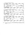
1
CONVENTIONS
SCIENCES DE LA MER
OCÉANOGRAPHIE PHYSIQUE
2001
Contribution à l'étude
de la variabilité climatique
de l'Océan Pacifique tropical sud ouest
Thierry DELCROIX
Yves GOURIOU
Fraçois MASIA
David './ARILLON
hl::;lnut de re<;ht=lche pour le développement
i i ~:a :.~
: : :. ~ - ~
Centre dp.
j\i0ur,,?~
Institut de ;i!cherche
pour le developpement
CONVENTIONS
SCIENCES DE LA MER
OCÉANOGRAPHIE PHYSIQUE
2001
Contribution à l'étude
de la variabilité climatique
de l'Océan Pacifique tropical sud ouest
Thierry DELCROIX
Yves GOURIOU
Fraçois MASIA
David VARILLON
Compte rendu de fin d'étude d'une recherche financée
par le Fond d'Investissement pour le Développement Économique
et Social des Territoires d'Outre mer (FIDES).
Contrat n099T06, financement 2488.00
Institut de recherche
pour le développement
©
IR D, Nouméa, 2001
/Delcroix, T.
/Gouriou, Y.
/Masia, F.
Narillon, D.
Contribution à l'étude de la variabilité climatique de l'Océan Pacifique tropical sud ouest
Nouméa: IRD. Decembre 2001.56 p.
Conventions: Sei. Mer; Océanogr. Phys. ; 7
HYDROCLIMAT; EL NINO; VARIABILITE SAISONNIAIRE; APPAREIL DE MESURE; PREVISION
CLIMATIQUE; ZONE TROPICALE/OCEAN PACIFIQUE SUD OUEST
Imprimé par la Service de Reprographie
Centre IRD de Nouméa
Décembre 2001
3
1. INTRODUCTION
Observer et comprendre le climat mais aussi pouvoir anticiper suffisamment à l'avance
ses anomalies constituent
des enjeux
scientifiques,
techniques
et
socio-économiques
incontestables. Le phénomène El Nino Southern Oscillation (ENSO) est le signal climatique
qui domine à l'échelle interannuelle dans le Pacifique tropical. L'analyse d'observations in situ
et alti métriques ainsi que les résultats de modèles ont permis ces dernières années de suivre
certains phénomènes en temps réel et de les prévoir environ 6 mois en avance. En dépit de ce
succès relatif, notre compréhension d'ENSO demeure incomplète, liée en partie aux manques
d'observations sur l'océan.
Le Pacifique tropical sud-ouest est une région d'intérêts multiples à la fois scientifiques
et socio-économiques. Cette région englobe une grande partie du réservoir d'eau chaude du
Pacifique où se trouvent les eaux les plus chaudes de la planète (>28°C). Elle est également
située entre les deux systèmes météorologiques du Pacifique qui définissent l'indice
d'Oscillation Australe (Tahiti et Darwin) et cette position géographique unique a suggéré à
certains auteurs que l'origine d'ENSO devait y être recherchée (Van Loon and Shea, 1985;
Holbrook and Bindoff, 1997). En dehors de l'aspect strictement scientifique, cette région
comprend les TOM (Territoires d'Outre Mer) Français et de nombreux Etats Insulaires et
Territoires, membres du Programme Régional Océanien de l'Environnement (PROE), désireux
de connaître leur environnement climatique et ses modifications passées, présentes et futures.
Les deux grands traits caractéristiques de la région sont l'existence de la Zone de
Convergence du Pacifique Sud (SPCZ; cf. Vincent, 1994) et du grand tourbillon anticyclonique
qui recouvre l'ensemble du Pacifique sud. La SPCZ est associée à des précipitations très
importantes (de 2 à 6 rn/an; e.g., Delcroix et aL, 1996) et le grand tourbillon à une circulation
océanique vers l'est au sud d'environ 15°S et vers l'ouest au nord de cette latitude. En période
El N ino, la SPCZ se déplace vers l'équateur et l'axe du grand tourbillon se déplace de quelques
centaines de kilomètres vers le sud (Wyrtki et Wenzel, 1984; DeJcroix et Hénin, 1989). Des
déplacements inverses sont observés en période La Nina. Les déplacements méridiens de la
SPCZ et du grand tourbillon entraînent de fortes anomalies atmosphériques et océaniques, en
particulier ils modifient de manière fondamentale la pluviométrie régionale, la salinité, Je niveau
de la mer et la circulation océanique avec renverse possible des courants zonaux. Nous savons
4
maintenant, sans toutefois en comprendre pleinement les mécanismes, que les anomalies
ENSO observées dans les TOM du Pacifique tropical sud-ouest peuvent être de signes
contraires aux anomalies de la bande équatoriale (Delcroix et Lenormand, 1997; Delcroix, 1998;
Alory et Delcroix, 1999 ; Nicet et Delcroix, 2000).
Le maintien et la mise en place d'observatoires du milieu océanique sont nécessaires
pour comprendre et aboutir à terme à une prévision opérationnelle d'ENSO, en particulier au
voisinage des TOM du Pacifique directement affectés par le phénomène. Dans ce cadre, la
proposition financée par le FIDES en 2000-2001 visait à améliorer l'observation et la
compréhension de la variabilité climatique à l'échelle régionale, en priorité à l'échelle d'ENSO
mais également à d'autres échelles de temps. Quatre types de travaux ont été effectués:
•
Le maintien d'un thermosalinographe (mesurant la température et la salinité) dans le lagon
de l'île de Wallis,
•
la mise en place d'un thermosalinographe sur un navire de commerce faisant une route
régulière dans le Pacifique tropical sud-ouest, avec transmission des données en temps réel,
•
la mise à disposition via Internet des données récoltées,
•
la valorisation scientifique et la publication de résultats liés à l'exploitation des données
récoltées.
Ces quatre types de travaux sont décrits tour à tour.
2. TRAVAUX EFFECTUES
2.1. Mise en place d'un thermosalinographe dans le lagon de l'île de Wallis
Un thennosalinographe de type Seabird SBE-21 a été installé prés de la passe de
Futumanimi (13°13'334S; 176°l5'094°E) sur l'île de Wallis le 22/0811998 par 9 m de
profondeur (Figure 1). Cet appareil aurait été enlevé sans le soutien financier du FIDES en
2000-2001. 11 est programmé pour mesurer et enregistrer la température et la salinité de
surface toutes les 30 minutes. La cellule de conductivité permettant de mesurer la salinité est
vérifiée tous les 6 mois environ et l'appareil est envoyé chez le fabricant SeaBird (USA) tous
les ans pour étalonnage des capteurs. Des prélèvements manuels d'échantillon d'eau de mer
sont effectués lors de l'opération de nettoyage des capteurs. Les mesures de température et
5
salinité de surface n'ont pas encore été exploitées scientifiquement en raison de la longueur
encore trop faible des séries temporelles. Les dOIU1ées récoltées sont en cours de validation.
Figure 1. Photographie du thennosalinographe sur son bâti à Wallis.
2.2. Mise en place d'un thermosalinographe sur un navire de commerce
Pour des raisons commerciales, le bateau Moana sur lequel il était prévu d'instaIler un
thermosalinographe (voir proposition initiale) n'a plus effectué de navettes régulières entre
Wallis, Fidji et la Nouvelle Calédonie à partir de début 2000. L'installation d'un
thermosalinographe a donc été effectuée sur le MIS Kyowa Hibiscus, navire effectuant le
même type de trajet avec en plus un aller retour sur le Japon et sur la Polynésie Française
(Figure 2). Le schéma de l'installation est décrit en détail dans Prunier-Mignot et al. (1999).
L'appareil installé mesure la température et la salinité de surface toutes les 15
secondes, une médiane est calculée sur 5 minutes, ces valeurs médianes sont stockées avec le
temps et la position GPS sur le disque dur d'un PC situé à la passerelle, les valeurs médianes
calculées sur 1 heure sont transmises en temps réel via le système GOES. La transmission
temps réel est conforme aux impératifs des programmes international GODAE et national
MERCATOR d'océanographie opérationnelle. Le thermosalinographe est nettoyé avec une
6
solution de Triton 1% lors de chaque escale à Nouméa et les tuyauteries instaJlées par nos
soins, qui relient le système de refroidissement du navire au thermosalinographe, sont
changées tous les ans. L'appareil est également envoyé chez le fabricant SeaBird (USA) tous
les ans pour étalonnage des capteurs.
Des prélèvements d'eau de mer, au niveau du thennosalinographe, ont été réalisées par
les officiers du bord ou par le personnel de la machine, à raison de deux échantillons minimwn
par jour. Ils visaient à minimiser l'effet de la dérive temporelle des capteurs de salinité, liée à
l'encrassage de la cellule, par ajustement des valeurs du thermosalinographe aux valeurs des
échantillons. Cette dérive peut être estimée à environ 0.1 psu / mois pour la salinité. Ces
tentatives n'ont hélas pas été très fructueuses car de nombreuses mesures issues des
échantillons d'eau de mer se sont avérées totalement irréalistes. Ces tentatives doivent être
reconduites.
Figure 2. Route type (en noir) du J\1JS Kyowa Hibiscus sur lequel est installé un
thermosalinographe. Les cercles représentent les thermosalinographes mouillés à Wallis et en
Nouvelle Calédonie.
7
2.3. Mise à disposition via Internet des données récoltées
L'installation décrite précédemment vient en
réalité
compléter un
réseau de
thennosalinographes installés sur des navires marchands par notre laboratoire depuis le début
des années 1990. Ce type de mesures existe sur plusieurs lignes de navigation, actuellement
sur 4 lignes Pacifique ouest et 3 lignes tour du monde. L'avantage de cette nouvelle installation
financée par le FIDES pour le Pacifique tropical sud-ouest, incluant les TOM français, est de
permettre un échantillonnage beaucoup plus fin à la fois dans le temps et dans l'espace de
cette région.
Figure 3. Couverture du CD-ROM rassemblant les mesures de salinité de surface des années
1969 à 2000 dans le Pacifique tropical (version 1.2). Voir aussi http://www.ird.nc/ECOP.
En adéquation avec les objectifs scientifiques du programme international CUYAR (et
avec un financement MERCATOR complémentaire), les mesures récoltées grâce à cette
nouvelle installation ont aussi été mises à disposition de la communauté scientifique nttachée à
l'étude de la variabilité climatique dans le Pacifique tropical. Un CD-ROM rassemblant
l'ensemble des mesures de salinité de surface effectuées depuis 1969 dans le Pacifique tropical
par ]'IRD et par d'autres organismes (IFREMER, NOAA, JAMSTEC, etc ... ) a donc été
rénlisé (Figure 3) et diffusé à plus de 200 scientifiques de part le monde. Ce CD-ROM a été
mis en accès libre en septembre 2000 via le site Web de notre laboratoire http://www.ird.ncIECOP.
8
Le site est réactualisé tous les 6-12 mois avec les données en temps différé qui continuent à
être récoltées et validées. Les procédures de validation et les codes de qualité attribués aux
données sont décrits dans le CD-ROM.
2.4. Valorisation scientifique et publications
Quatre articles de rang A utilisant les données nouvellement récoltées ont été publiés
(ou sous presse) en 2000-2001. Il s'agit:
•
D'une étude spécifique sur la variabilité saisonnière et liée à ENSO dans le Pacifique
tropical sud ouest sur la période 1976-2000 (Gouriou et De1croix, 2001).
•
D'une étude sur la variabilité de la salinité de surface à Fidji, à la fois avec des mesures
directes et en utilisant des données coralliennes (Lebec et al., 2000).
•
D'une étude sur la variabilité de la température de surface à Vanuatu dans"laquelJe la
période actuelle est comparée à la période du mid-holocène (Corrège et al., 2000).
•
D'une étude sur la variabilité de la température de surface en Nouvelle Calédonie dans
laquelle la période actuelle est comparée à la période du petit age glaciaire (Corrège et al.,
2001).
Ces quatre articles sont reproduits en Annexe.
9
REFERENCES
Alory G. et T. Delcroix, ] 999. Climatic variability in the vicinity of Wallis, Futuna and Samoa
islands (l3°S-l5°S; l80 o -170 0 W). Oceano. Acla, 22, 249-263.
Correge T., T. Delcroix, 1. Recy, W. Beck, G. Cabioch et F. Le Cornee, 2000. Evidence for
stronger El Nino Southern Oscillation (ENSO) events in a mid-Holocene massive coral.
Paleoceanography, 15,465-470.
Correge, T., T. Quinn, T. Delcroix, F. Le Cornec, 1. Recy and G. Cabioch, 2001 : Litte Ice Age
sea surface tempe rature variability in the southwest tropical Pacific, Geophys. Res. Let.,
28,3477-3480.
Delcroix T. et C. Hénin, 1989. Mechanisms of subsurface thermal structure and sea surface
therrnohaline variabilities in the southwestern tropical Pacific during ] 979-85. J Mar.
Res., 47, 777-812.
Delcroix T., C. Hénin, V. Porte et P. Arkin, 1996. Precipitation and sea-surface salinity in the
tropical Pacific. Deep Sea Res., 43, 1123-1141.
Delcroix T. et O. Lenormand, 1997. ENSO signaIs in the vicinity of New CaJedonia, southwestern Pacific. Oceano. Acla, 20, 481-491.
Gouriou, Y. et T. Delcroix, 2001. Seasonal and ENSO variations of sea surface salinity and
temperature in the South Pacific Convergence Zone during 1976-2000. J Geophys. Res.,
In
press.
Holbrook, NJ. and N.L. Bindoff, ]997. Temperature variability
In
the Southwest Pacific
Ocean between 1955 and 1988,J C/imale, 10,31035-1049.
Le Bec N., A. Juillet-Leclerc, T. Correge, D. Blamart, and T. De!croix, 2000. A coral 8 18 0
record ofENSO driven sea surface salinity variability in Fiji (South - Western Tropical
Pacific). Geophys. Res. Letler, 27,3897-3900.
Nicet 1.B. et T. Delcroix, 2000. ENSO-related precipitation changes in New Caledonia, South
Western Tropical Pacific. 1969-1998. Mon. Wea. Rev., 128,3001-3006.
Prunier-Mignot, M., D. Varillon, L. Foucher, J.-M. Ihily, B. Buisson, F. Masia, C. Hénin,
M. Ioualalen and T. DeJcroix, 1999. Manuel d'installation et de maintenance d'un
thermosalinographe embarqué / Users guide for thermosalinograph Installation and
maintenance aboard a ship. Notes techniques, Sciences de la Mer, Océanogr. Phys.,
Centre ORSTOM de Nouméa, 13, 102 pages.
10
van Loon H. and 1. Shea, 1985. The Southem Oscillation. IV. The precursors south of 15°S to
the extremes of the Oscillation. Mon. Weather Rev., 113,2063-2074.
Vincent, D.G., 1994. The South Pacifie Convergence Zone (SPCZ): a review, Mon. Weather
Rev., J22, 1949-1970.
Wyrtki K. and 1. Wenzel, 1984. Possible gyre-gyre interaction in the Pacifie ocean. Nature,
309, 538-540.
.
.
.
Seasonal and ENSO Variations of Sea Surface Salinity and Temperature in th'e South
Pacific Convergence Zone during 1976-2000
Yves Gouriou and Thierry Delctoix
Centre lRD, B.P. A5, 98 848 Nownea, New Caledonia
.
e.rnail : [email protected]
.
Accepté dans Journal of Geophysical Research
2001#830
October 2001
Index term:
4215 Climate and interannual variability
4223 Descriptive and regional oceanography
4522 El Nifio
Key Words: ENSO - Variability - Sea Surface Salinity - Sea Surface Temperature - South Pacifie
Convergence Zone - Front '
2
Abstract
Sea surface salinity (SSS) and temperature (SST) data collected from voluntary observing
ships over 25 years (1976-2000) are analyzed in the, South Western Tropical Pacifie (100S-24°S /
1600E-140°W). This region lies under the South Pacific Convergence Zone (SPCZ), at the southern
edge of the western Pacifie warrn pool, between Tahiti and DarWin the two places whose atmospheric
sea level pressure difference is used to defme the Southem Oscillation Index (SOI). Complementary
data such as precipitation are used to assist in the analysis. The mean and seasonal variations of these
parameters are described. An Empirical Orthogonal Function (BOF) analysis of low-pass filtered timeseries is then performed to extract the interannual variability. AlI parameters show an interannual
signal which correlates weIl with the SOI. The South Western Tropical Pacifie Ocean is saltier and
colder during El Nino than during La Nina events. In the southwestem part, there is a shortage
(excess) in precipitation during El Nino (La Nina) events. The greatest anomalies appeared during the
last La Nina, in 1996 and 1999 as regards SST and in 1999 and 2000 as regards SSS. SST and
precipitation ENSO-related anomalies are an order of magnitude smaller than seasonal anomalies,
while the SSS ENSO-related signal is twice as strong as the seasonal signal. These facts reflect the
northeastward (southwestward) shift of the SPCZ during El Nifio (La Nifia) events. While consistent
with precipitation changes, the ENSO-related variability in SSS can also he partly explained by the
displacement of the salinity front that separates fresh warm pool waters from salty subtropical waters.
Computation of surface geostrophic CUITent
anomalies
from
GEOSAT
(1987-1988)
and
TOPEX/Poseidon (1993-2000) indicates that westward CUITent anomalies developed during the
1987/88 and 1997/98 El Nino and are linked to the displacement of the salinity front. The South
Western Tropical Pacific salinity front moves westward (eastward) in contrast to the equatorial salinity
front which moves eastward (westward) during an El Nino (La Nina) event.
3
1. Introduction
Recent studies [Pieaut et al., 1996, 1997,2001; Vialard and Delec/use, 1998J high1ighted the
dynamica1 and biogeochimica1 importance of the Pacific equatoria1 frontal zone (..,.175°W) which
separates the wann/fresh pool to the west from the colder and saltier waters to the east (Figure 1). This
front is mainly defined by a zonal gradient of Sea Surface Salinity (SSS), whereas Sea Surface
Temperature (SST), gradually increasing to 28.5°C from east to west, is relatively constant (Figure 1).
These studies particularly stressed the front's relationship with El Nino Southern Oscillation (ENSO)
variability, demonstrating that its zonal displacements at an interannuai time-scale are mainly due to
advection processes rather than to the Evaporation/Precipitation budget.
The climatic importance of the equatorial salinity front led us to look more closely at a second
frontal region, located south of the equator (-170 0W-15 OS), at the southeastern side of the warm pool
(Figure 1). This secondary salinity front is the result of the juxtaposition of the high salinity waters
formed in the subtropical region (20 0S-120°W), where evaporation exceeds precipitation, and of the
low-salinity waters of the warm pool area, where precipitation exceeds evaporation. This frontal
region is located under the South Pacific Convergence Zone (SPCZ) which plays a significant role in
global atmospheric circulation. The SPCZ extends southeastward from Papua New Guinea (-5°S145°E) to about 30 oS-120oW, over southeastward wann-SST, low-SSS (in its western part), and
maximum precipitation tongues. The importance of the SPCZ has been brought to light since the
advent of satellite imagery, and the use of Outgoing Longwave Radiation (OLR) data as a proxy for
deep tropical convection and global circulation. The allOuaI cycle of the SPCZ is thus characterized by
high deep convection activity during the austral winter and 10w deep convection activity during the
summer [Meehl, 1987; Vincent, 1994]. The SPCZ shifts north and east (south and west) of its average
position during an El Nino (La Nifia) event [Pazan and Meyers, 1982; Vincent, 1994].
Few previous studies investigated the links between El Nifio and La Nina and the interannuai
variability of oceanic andatmospheric parameters in the South Western Tropical Pacific (SWTP),
defined here as the region between 24°S-10oS and 160 0E-1400W (Figure 1). Delcroix and Hénin
(1989] analyzing Voluntary Observing Ship (VOS) data between 1979 and 1985 stressed the influence
of the 1982-1983 El Nino event on SST, SSS, and subsurface thermal structure variability. They
4
particularly noted that SSS increased by + 1 in early 1983, mainly in response to a rainfall shortage due
to a northward migration of the SPCZ. Delcroix and Hénin [1991], studying the 1972-1988 SSS
variability along 4 main shipping routes, found that during the wann phases of ENSO, SSS is fresher
than average west of 150 0 W within 8°S-8°N, and saltier than average poleward of 8° latitude (i.e. in
the SWTP). Delcroix et al. [1996] indicated that the 1974-1989 interannual variations of SSS in the
SWTP, are closely re1ated to the rainfall regime linked to the displacements of the SPCZ. Nevertheless
the above-cited authors did not entirely role out the influence of advective processes by CUITent
anomalies.
Since the early analysis of Delcroix and Hénin [1989], the VOS program has been maintained,
and was improved in 1992 when vesse1s were equipped with thennosalinographs (TSG) [Hénin and
Grelet, 1996]. Currently, we possess 25 years (1976-2000) of SSS and SST measurements in the
SWTP region, encompassing 6 El Nino and 3 La Nifia events. The aim of this study is to describe the
seasonal and interannual variability of SSS and SST in the SWTP and in particular the abovementioned frontal region. In addition, sorne tentative explanations accounting for the observed patterns
are investigated using satellite-derived precipitation data and surface geostrophic CUITent anomalies
computed from altimeter measurements.
The paper is structured as follows. SSS, SST, precipitation data, and their processing and
gridding procedure are shown in section 2. Mean field and seasonal cycles of SSS, SST, and
precipitation are briefly described in section 3 to put our analysis in context. The ENSO variability of
the above parameters is then exallÙned in section 4 using an Empirical Orthogonal Function (EOF)
analysis. A conclusion appears in section 5.
2. Data and data processing
2.1. SSS and SST measurements
In-situ SSS and SST measuremeilts, collected through a VOS program initiated by !RD
(Institut de Recherche pour le Développement, fonnerly ORSTOM) in 1969 constitute the main source
of data for this study. Before 1992, meteorological buckets were employed to collect salinity samples
and measure SST along regular shipping routes. Bucket measurements were generally made every 30-
5
60 nautical miles (50-100 km) at about every 6 hours. From 1992, these merchant ships were equipped
with ThermoSalinoGraphs (TSG) [Hénin and Grelet, 1996] which provide one measurement every 15
seconds. Before being entered in the data base, a median filter is applied to TSG time series to give
one value every 5 minutes. In the present analysis a median filter was applied to the 5-minutes time
series to give one value representing one hour-measurements.
Hénin and Grelet [1996] deduced the quality of the bucket and TSG measurements through
comparison with simultaneous Conductivity-Temperature-Depth (CTD) measurements. Bucket data
are less accurate than TSG data, and ~e 'bucket minus CID' difference is much more variable than the
'TSG minus CID' difference. Taking CID data as a reference, we added the following values obtained
by Hénin and Grelet [1996] to the measurements: bucket salinity (-0.1), bucket temperature (-0.15),
TSG salinity (+0.02), and TSG temperature (-0.2).
About 115 000 SSS and SST (41% bucket, 59% TSG, 0.02% CID) observations were
collected in the study area. Before being entered in the data base, the following validation tests were
applied to the bucket and TSG measurements: a) for each voyage, data were plotted on a map to detect
position errors, and obvious outliers b) within the tropics, SSS lower than 30 or greater than 37were
rejected. TSG data were also visually compared to mean monthly values ±1 standard deviation. For the
purpose of the present study, an additional validation test was then applied. Data were grouped in 2°
latitude by 10° longitude bins. In a given bin, individual measurements greaterllower than the
c1imatological monthly value plus or minus 5, 4, and 3.5 times the standard deviation were rejected.At
the end of the additiona1 test, 1% of the SSS and 2% of the SST data were rejected.
The data were then averaged on a monthly basis and gridded (2° latitude x 10° longitude x 1
month) using a triang1e-based linear interpolation. The number of SSS data per month in the area
under study is displayed in Figure 2. The SST data distribution presents almost the same pattern (not
shown). Between 200 and 400 measurements were taken per month before 1992 when the VOS were
equipped with TSGs. After that date there is a significant increase up to 1200/month. The mean
number of measurements per month in every bin is shown in Figure 3. There are fewer than 5
measurements per month in the center of the region, and east of 1700 E, south of 22°S and north of
14°S. It must be noted that this spatial distribution reflects a difference in temporal distribution. While
6
time series are almost complete in the center of the region, there are practically no data after 1992 east
of 1800 W, south of22°S arid north 13°S, making any extrapolation dubious. Therefore the bins east of
1800 W, south of22°S and north 13°S were excluded from the analysis.
2.2 Additional data
Rainfall data arederived from the analysis of Xie and Arkin [1997]. They result from the
merging of different data sources: rain gauges; a numbet of satellite estimates, and forecasts from'the
NCEP (National Centers for Environmental Prediction) re-analysis. The data are available monthly, on
a 2.5°-latitude by 2.5°-longitude spatial grid, from 1979 to 2000. To match the SST-SSS grid size, we
first interpolated the rainfall data every 2° of latitude, and then averaged the data' over 10° of
longitude.
Two sets of data relative to satellite-derived surface CUITent anomalies are available: GEOSAT
from November 1986 to February 1989 [Picaut et al., 1990; Delcroix et al., 1994], and
TOPEXIPoseidon from October 1992 to October 2000 [Delcroix et al., 2000]. Anomalies of zonal and
meridional geostrophic velocity are computed every 5 days on a O.5°-latitude by 50 -longitude grid. For
GEOSAT, the anomalies are computed relatively to the 1986-1989 period, while the TOPEXIPoseidon
anomalies are computed relatively to the 1993-1995 period. Comparison of velocity anomalies
deduced from the TOPEXIPoseidon altimeter data with the CUITent anomalies given by Doppler
CUITent measurements made at the equator with the Tropical Atmosphere-Ocean (TAO) aITay gave
good results [Delcroix et al., 1994; Delcroix et al., 2000]. Given the absence of direct CUITent
measurements away from the equator, this type of comparison cannot be made in the SWTP. As
geostrophic computation is directly related to the inverse of the Coriolis parameter, computation eITors
decrease away from the equator. We are thus reasonably confident about the anomalies of geostrophic
velocities computed in the SWTP.
The da Si/va et al [1994] data base derived from the Comprehensive Ocean-Atmosphere Data
Set (COAOS) includes one of the longest available evaporation time series. It was computed using
bulk formulas and ship report data. In da Si/va et al's atlas, this parameter is available on a monthly
7
bàsis from 1976 to 1993, on a 1°x 1° horizontal grid. The data were averaged over a spatial 2°x 100
grid.
Finally, surface wind stress r will be used to evaluate the magnitude of the Ekinan drift
(Ue = r/pjh;
Ve
=
-rxfpfh; wherefis the Coriolis parameter, p the sea-water density, and h the depth of
the Elcman layer). In this study we computed the surface wind stress from the Florida State University
(FSU) pseudo-windstress [Leg/er and O'Brien, 1988] available on a montWy basis, on a 2° latitude by
2° longitude grid. Data were averaged over 10° oflongitude to fit the SSS and SST grid size.
3. Mean fields and seasonal variability
3.1 Mean fields
Mean SST and SSS distributions over the Pacifie Ocean, from 1979 to 1992, are summarized
in De/croix [1998]; figure 2 of this paper being reproduced here (Figure 1). A zoom on the SWTP
region is presented in Figure 4 for the 1976-2000 period. These maps are very similar to those
presented in De/croix and Hénin [1989], computed for the years 1979-81+1984-85, but excluding the
1982-1983 El Nino period.
This region is characterized by a horizontal SSS gradient between the south-eastward oriented
tongue of fresh water featuring the warm pool in the north-west part of the study area, and the
westward oriented tongue of high salinity water advected by the southem branch of the South
Equatorial CUITent from the central south Pacifie (Figure 4a). The low-salinity tongue lies under the
SPCZ, and minimum salinity
«
34.7) is found where precipitation is maximum at 100S-175°E (>0.25
m/month) (Figure 4c). Precipitation is low on either side of the SPCZ, in the southwest corner close to
New Caledonia, and in the east, in French Polynesia, where salinity is highest.
The SST field presents quasi-zonal1y oriented isotherms, with waters warmer than28°C north
of 16°S. The 28°C isotherm is general1y used as an arbitrary limit defining the area of the warm pool.
South of 16°S the meridional gradient of SST increases, and SST falls below 25°C south of22°S.
Seasonal and interannual variability is apparent in the montlùy time series of SSS averaged
over the SWTP region (figure 5). During non-ENSO years (for example during the 1979-1982 or
8
1984-1986 periods), SSS is minimum in March (around 35.1) and maximum in September (around
35.4). The interannual variability of SSS is clearly linked to El Nino or La Nina, as a significant
divergence from the mean (35.29) is observed following extreme values of the SOI curve. SSS
increases during El Nino (1976/77, 1982183, 1987, 1991/92, 1993, 1997/98) and decreases during La
Niiia (1988/89, 1986, 1998/99/00). The greatest divergences occurred during the 1982/83 El Nino,
when SSS reached 35.85, and during the 1988/99/00 La Niiias, when SSS decreased to 34.75.
In order to quantify the relative amplitude of the seasonal and interannual signaIs and to
obtain a synthetic view of seasonal and inter-annual variability, an EOF analysis is performed on SSS,
SST, and rainfall fields. For each parameter, the "high frequency" signal is separated from the
interannual one in the following manner: we frrst smooth the original time series with a 25-month
Hanning filter [Blackman and Tuckey, 1958] to get variations at periods >12 months, then subtract the
original time-series from the filtered ones to obtainvariations at periods :;;12 months. The EOF
analysis is applied separately to each variable: on the "high frequency" variations to focus on seasonal
oscillations, and on the "low frequency" variations to focus on the ENSO-like oscillations. In this
procedure, the twe1ve-first and twelve-last months of the time series cannot he filtered, and are
therefore excluded from the analysis. In the fol1owing section we describe the EOF performed on the
"high frequency" variations.
3.2 Seasonal variability
The first EOF on SSS represents 31% of the data variance (12% for EOF 2). A seasonal cycle
is apparent in the SSS time function (Figure 6a), with low salinities around March and high saI inities
around September. Maximum salinity variability has a diagonally oriented shape from Samoa (-14°S172°W) to French Polynesia (-16°S-145°W), roughly along the mean axis of the SPCZ (Figure 6b).
.The amplitude of the seasonal signal, from maximum to minimum, is about 0.5 in the Samoa region
(peak to peak variation of about 2xO.25). This amplitude is minimum in the south close to New
Caledonia (peak to peak variation of 0.1).
The first EOF on SST represents 81 % of the data variance (3% for EOF 2). The time function
variability is clearly dominated by seasonal fluctuations (Figure 7a). As expected, high (low)
9
temperatures are found during the austral summer (winter). The spatial pattern presents zonaIlyoriented isolines reflecting low amplitude variations in the north-east corner of the studyarea (-1°C,
from peak to peak), and high amplitude variations in the south-west, close to New Caledonia (>2.5°C)
(Figure 7b).
The first EOF on rainfall, which represents 51 % of the variance (18% for EOF 2), reflects
seasonal variations, with maximum (minimum) precipitation during the austral surnriler (winter)
(Figure 8a). The maximum amplitude of variation (-0.25 m/month from peak to peak) is situated
around 13°S-170oW, close to maximum SSS variation (Figure 8b and figure 6b). Seasonal variability
diminishes gradually southward to about -0.06 m/month (from peak to peak).
The second EOF of these parameters are not discussed here as we found no obvious related
physical mechanisms.
4. Interannual variability
4.1 EOF Analysis
As shown in the previous section, SSS, SST, and rainfall are influenced by seasonal
variability, but modulation at longer periods is clearly visible in the original time series (Figure 5). We
now present the "low frequency" time series and compare them to the SOI, smoothed with a 25-month
Hanning filter.
4.1.a Sea surface salinity
The first EOF on SSS represents 58% of the data variance. The time function (Figure 6c) is
weIl correlated with the SOI (Ro=0.70 with no time lag, Rm,,,=0.73 with a two-month time lag). The
spatial pattern (Figure 6d) indicates that maximum variability is centered near 15°S-175°W along the
mean axis of the SPCZ. It should be noted that the 'seasonal' and ENSO-related signaIs display very
similar spatial patterns (Figure 6b and 6d), indicating the key role of the SPCZ. During El Nino events
(1976/77, 1982/83, 1986/87, 1991/92, 1993, 1997/98), the SWTP is saltier than during La Nifia events
(1988/89, 1996, 1998/99/00). In early 1983, during the 1982/83 El Nino, the increase in salinity was
0.5, in the Samoa-Fiji region. In 1989, during the 1988/89 La Nina event, the decrease in salinity was
10
0.62 in the same region. Thusin the SWTP, ENSO signaIs have twice the impact of seasonal signaIs
on SSS.
The agreement between the SOI and SSS is less convincing during the 1993-1995 period
(Figure 6c). While the SOI stayed negative from 1992 to the end of 1995, SSS returned to mean values
around mid-1993 and was fresher than average from the beginning of 1994 to mid-1996, rather as if
the SWTP were not influenced by the quasi-permanent unusual El Nino conditions that lasted froin
1993 to 1995 at the equator [Trenberth and Hoar, 1996; Latif et al.~ 1997]. The strong 1997/98 El .
Nino event gave rise tothe smallest positive SSS anomaly of the observed El Nifios in the time series,
and the greatest negative anomalies of the period of sttidy were observed during the 1998/99 La Nina
event. Due to the filtering technique, the 1999/00 La Nina dOes not appear on figure 6c, but the
montWy time series of SSS averaged over the SWTP region indicates that the negative SSS anomaly
in 2000 is as great as in 1999 (Figure 5).
No clear explanation was found to account for the second EOF which retains 19% of the total
variance.
4.J.b Sea surface temperature
The frrst EOF on SST represents 45% of the variance (21 % for EOF 2). Correlation between
the time fonction and the filtered SOI curve is
~=0.51
with no lag, and Rmax=0.53 with a 2-month lag
(Figure 7c). SST is colder (respectively warmer) during El Nii'io (respectively La Nina) events, which
is consistent with Delcroix and Lenormantls [1997] analysis for the New Caledonia sector (22°S_
165°E). The amplitude of variation due to inter-annual variability (---O.75°C maximum in 1996 and
1999, in the Vanuatu region) is less pronounced than the amplitude of the seasonal variations. Though
weak, this ENSO signal is still detectable in the paleorecord of coral drilled in Vanuatu [Corrège et
al., 2000]. Maximum interannual variability occurred at the southern edge of the mean position of the
warm pool, in between Vanuatu and the Fiji islands (Figure 7d). In spite of a good phasing agreement
(Figure 7c), there is no obvious link between the intensity of the SOI and the amplitude of the SST
anomaly. Indeed, the very strong 1982183 El Nino event has a much weaker SST signature than the
Il
sma11er 1986/87 event. The greatest anomalies occtnTed during the 1996 La Nina, although the SOI is
only slightly positive, and during the 1999/00 La Nina.
4.1.c Precipitation
The flfst EOF on precipitation represents 53% of the variance (19% for the EOF 2). There is a
clear correlation between the time function and the SOI (Ro=0.80 with no lag, Rmax=0.87 with 2- and
3-month lag) (Figure 8c). The spatial pattern (Figure 8d) indicates that rainfa Il interannual variability
has a converse signal on the southwestern and the northeastern sides of the SWTP. There is a
precipitation shortage (excess) over Samoa, Fiji, Vanuatu, Solomon, and New Caledonia during El
Nino (La Nina) events, while there is a slight precipitation excess (shortage) over French Polynesia.
This pattern is in line with the global analysis made by Meehl [1987] indicating that during strong
monsoon events over India, corresponding roughly to La Nifia events, rainfa11 increased to the west of
the SPCZ axis, and decreased to the east of the SPCZ axis. This is also in agreement with regional
analysis made for New Caledonia from a set of rain gauge stations [Morlière and Rebert, 1986; Nicet
and Delcroix, 2000], and for SamoaIWallis [Alary and Delcroix, 1999]. The amplitude of variation
due to 10w frequency modulation is less pronounced than that of seasonal variation. For example, the
precipitation shortage due to the 1982/83 El Nifio in Fiji (18°S-178°W) is about -0.04 m/month, and
the precipitation excess during the 1988/89 La Nifia event in the same region is 0.06 m/month. This
can be contrasted with the amplitude (from minimum to maximum) of the seasonal signal which is of
the order of 0.2 m/month. In New Caledonia (22°S-165°E), where seasonal variations are amongst the
lowest in the SWTP (Figure 8b), and interannual variability is high (Figure 8d), Nicet and Delcroix
[2000] showed that ENSO-related precipitation changes range within 20%-50% of the mean annual
values.
4.1d Evaporation
In order to test the potential effect of evaporation changes on SSS variability, we used the da
Si/va et al. [1994] data covering the 1976-1993 period. The 1976-1993 averaged evaporation values
(not shown) are minimum below the mean SPCZ axis (-0.13 m/month) and maximum south of it,
between Fiji and New Caledonia (-0.15 m/month). The fust EûF (not shown) extracts a clear seasonal
12
.'
signal in the SWTP, with maximum variability south of 16°S and minimum variability along lObS.
The amplitude (from maximum to llÙnimum) of the seasonal variation is about 0.08 m/month, weaker
than the seasonal precipitation cycle. This means that the seasonal variation in the 'Precipitation minus
Evaporation' difference is mainly dependent on precipitation. The first EOF of the low-frequency
evaporation signal (not shown) is relatively flat and does not show any correlation with the SOI.
4.2 Time-space evolution of the frontal zone
4.2. a SST, SSS, and precipitation fields
Time-Iongitude and time-Iatitude plots of the SSS, SST, and precipitation fields were drawn
up to further assess the relationship between changes in these parameters and ENSO. We chose to use
the time-Iongitude plot at the latitude of 17°S (plate 1a, 1c, 1e), where the SSS front is strongest
(Figure 4a) and time series are complete for every longitude; and the time-Iatitude plot at the longitude
of 175°E (plate lb, Id, If), as time series are complete there from 11°S to 23°S. In these plots, data
have been low-pass filtered with a 25-month Hanning filter toeliminate periods :.:;12 months, and the
filtered SOI is superimposed on these plots.
Plate 1a and plate lb clearly show that the salinity front separating the low-salinity water
under the SPCZ from the high-salinity waters of the south central Pacifie, oscil1ates back and forth in
the zonaVmeridonal direction fol1owing the SOI. The correlation between the SOI and the
displacement in longitude of the 35.5 isoline is
~=O.59
(Rmal< equals also 0.59 with a one- and two-
month lag). The correlation with the shift in latitude of the 35 isoline is
~=0.62
CRœx=0.84 with a
five-month lag). As the displacements occurred in both east-west and north-south directions, they
indicate that the front moved in a northeast-southwest direction. Saline waters (> 35.25, shown in
yellow to red in the plots) invaded the north-west portion of the area during El Nino events, at the end
of 1977,1983, 1987,1993 and 1998; while low-salinity waters moved south-eastward during La Niiia
periods. Confmning the EOF analysis, the salinity front stayed close to its mean position in longitude,
around 170 o W, during the 1993-1995 prolonged warm events.
As the mean SST field is quasi-zonal1y oriented (Figure 4b), it is mainly in the north-south
direction that we can observe displacements of surface isotherms. This is the case in plate 1d where
13
there is a tendency towards southward (respectively northward) shifts of the warm pool (SST> 28°C)
during La Nifia (respectively El Nifio) events.
The time-evolution of the north-south movements of the precipitation field also corresponds
closely to the SOI: the tongue of maximum precipitation (yellow to red in Plate 1f) extends southward
(northward) during La Nifia (El Nifio) events, in relaqon to the SPCZ southwestward (northeastward)
displacements. An exception occurred at -the end of 1989 and the beginning of 1990 with a
precipitation shortage from II oS to 23°S, although there is no minimum in the SOI that might indicate
an El Nifio event (plate 1t). The time-Iongitude precipitation plot does not display any clear front
(plate le). Precipitation is minimum in the east and in the west of the SWTP. In the center of the
region, precipitation variability is also linked to the SOI. Precipitation is minimum in 1983,
1987,1992, and 1998, and maximum in 1981182,1984/85, 1989, and from 1993 to 1996.
To sum up, there are southward incursions of the warm pool in the SWTP during La Nina
events. Deep atmospheric convection is closely linked to SST above 28°C, as is the position of the
SPCZ (see also Vincent [1994]). It is thus not surprising that rainfall increases in the SWTP during La
Nifia events.
This excess of precipitation is qualitatively. consistent with interannual variation in the
.
SSS-front position. Besides, since Delcroix and Hénin [1989] have shown that during the 1982/83 El
Nifio the South Equatorial Current was stronger than usual, zonal advection could also possibly
account for the interannual displacement of the SSS front.
4.2.b Potential role ofzonal and meridional advection
Reverdin et al. [1994] estimated mean surface current from buoy drifts and CUITent meter
records, between January 1987 and April 1992, for the tropical Pacific. In the SWTP, at 17°S, the
mean zonal component of the surface current is westward, east of 175°E, and eastward, west of 175°E.
Thus there is a tendency for zonal convergence of the surface currents to strengthen the SSS front.
One means of obtaining information on the surface currents at inter-annual time-scale is to use
altimeter data, which allow computation of geostrophic current anomalies. Two major contrasting
periods were sampled by the altimeters, the 1987-1989 El Niiio/La Nifia with GEOSAT, and the 1997-
14
2000 El Nino/La Nina with TOPEXIPoseidon. Anomalies of surface geostrophic zorial currents and
SSS field are displayed along 17°S in plate 2 for these two periods. The velocity anomalies are
generally within ±5 cms· l , though they exceed these values for a few months in 1987 and in 19981999. During the 1987/88 El Nino, a westward anomaly (>5 cm
S'l)
is present from February 1987 to
July 1987, between l700E and 1600W. Dtiring the second halfofthe 1987-year and the beginning of
1988 an eastward anomaly developed (>5 cm S·I) (plate 2d). During the 1997/98 El Nifio a westward
ve10city anomaly (>10 cm S'l) occuried between 1800W and l65°W, from the beginning of 1998 to
September 1998 (plate 2b). Then an eastward velocity anomaly, reaching 10 cm S·l, occurred from the
beginning of 1999 to July 1999. In aIl these cases, the westward ve10city anomaly preceded by 2-3
months the westward extension of the SSS salinity tongue, and the eastward retraction of this torigue
coincided with the eastward velocity anomaly (plate 2a and 2c) strongly suggesting that, qualitatively,
zonal geostrophic advection plays a role in the east-west movement of the zonal front.
The meridional current anomalies computed from TOPEX/Poseidon altimeter data vary within
±2 crns'} from 1992 to 1999 (not shown). A northward anomaly develops at 17°S-1800W, during the
second part of 1988. This is consistent with the westward anomaly observed at the same position and
the northwestward displacement of the SSS front, although this anomaly is very slight (2-3 cms· l ).
To obtain a complete picture, the effect of the interannual anomalies of the Ekman drift in
front displacements has to he estimated. While the time function of the first EOF of the zonal
component of pseudo-windstress is not correlated with the SOI, there is a very close correlation
(Rmu=0.88 with 1-month time lag) between the time function of the first EOF of the meridional
component of pseudo-windstress and the SOI (not shown). This close relationship was to be expected
since the SOI is a measure of the variability of the sea level atmospheric pressure gradient between
Tahiti and Darwin, and so and so is tightly related to the meridional geostrophic component of the
wind. It is therefore not surprising that the zonal component of the Ekman drift (lIe = r/pjh) varies in
phase with the SOI: westward (eastward) anomalies of Ekman ve10cities occurred during El Nino (La
Nina) events. Onedifficulty in estimating the magnitude of the Ekman velocity cornes from our
inability to quantitatively scale the Ekman depth (h) and its low frequency variability. Using a realistic
15
h=30 m at 17°S results in a westwaid current anomaly smaller than 3 cm
and an eastward anomaly lower than 2 cm
S-I
S·I
at the beginning of 1998,
in January 1999 and in January 2000. These currents
thus reinforce the zonal component of the geostrophic velocity although they are of a smaller order Of
magnitude.
Based on XBT data, Delcroix and Hénin [1989] showed that during the 1982183 El Nifio event
isotherms rose in the northem part of the SWTP, through Ekman purnping, in relation with the
northward displacement of the SPCZ. This rise was accompanied by a southward shift of the center of
the large-scale anticyclonic gyre reinforcing the westward flowing SEC in the SWfP region. This
southward shift during the 1982/83 El Nifio event was also evident in sea level data [Wyrtki, 1975,
1984]. It implies a stronger than usual SEC from April to July 1983, concomitant with the
northeastward displacement of the SSS front and consequently an increase of SSS in the SWTP.
5. Conclusion
The analysis of SSS, SST and precipitation changes over 25 years (1976-2000) in the SPCZ
region (10oS-24°S; 160o E-140°W) brings out the close relationship between the time-variability of
these parameters and El Nino or La Nifia. This is consistent with previous studies limited to shorter
time periods [Delcroix and Hénin, 1989, 1991; Delcroix et al., 1996]. The present study deals with an
unprecedented long time series encornpassing six El Nifio (1976/77, 1982/83, 1987, 1991192, 1993,
1997/98) and three La Nifia (1988/89, 1986, 1998/00) events. Our analysis confirms that SSS is
higher, SST and precipitation are lower during El Nifio events than during La Nifia events. The
amplitude of this interannual signal is an order of magnitude less than the amplitude of the seasonal
signal for SST and precipitation, whereas it is twice the amplitude of the seasonal signal for SSS.
It is worth noting that the greatest anomalies of the time series (1976-2000) occurred during
the last La Nina events, in 1999 and 2000 for SSS, and in 1996 and 1999 for SST. As aIl ENSO
variations are mainly due to the southeastward (northward) displacement of the warm pool during La
Nina (El Nino) events, the greatest changes in SST and SSS amplitude during the 1990s thus reflect
enhanced displacements of the warm pool.
16
In the equatorial band, the low frequency displacements of the SSS front were shown to be
mainly due
to
zonal
advection
by
oceanic
currents
and,
to
a
lesser
extent,
to
the
Evaporation!Precipitation budget, since the convection zone followed the migration of the wannlfresh
pool [Picaut et al., 1996; Delcroix and Picaut, 1998]. In the SPCZ region the displacement of the SSS
front still correlates closely with the SOI, and it moves both zonally and meridionally along a
northwest-southeast oriented axis. Surface geostrophic current anomalies reveal that in i987/88 and
1998/99, westward and slight northward currentanomalies develop for 6 months during the El NÎfio
event, almost in phase with the north-westward displacement of the high salinity waters. These current
anomalies are then reversed and give way to· eastward current anomalies in phase with the southeastward displacement of the fresh waters.
Remarkably, when the SSS front along the equator shifts eastward during an El Nifio event,
bringing warrn and fresh waters to the central Pacific, the SSS front in the SWTP moves in the
opposite direction toward the north-west, bringing salty and cold waters to the south-western tropical
Pacific.
With the data available,· it would be unrealistic to try to quantify the relative importance of
advection versus evaporation/preCipitation budget in the displacement of the SSS front. Firstly because
altimetry only enables us to compute the anomalies of geostrophic ClUTents and we do not know the
mean current in the period under study. Secondly because it is difficult to obtain a reliable
evaporation/precipitation budget at interannual time scale. Thirdly because we do not know the depth
of the salinity mixed layer, a terrn which appears in the salt conservation equation. We realize that to
be conclusive this analysis should be more quantitative. This could be achieved with models
adequately reproducing our observations; as far as we know, this has not yet be done for the SPCZ
region.
Acknowledgement.
The 1976-2000 bucket and TSG data set represents the combined effort of many IRD colleagues
involved in the ship-of-opportunity program and particularly owes much to Luc Foucher, Jean-Marc
Ihily, and David Varillon for the recent measurements. The satellite-derived geostrophic CUITent
anomalies were processed by François Masia, at IRD-Nouméa. We are also indebted to aH our
colleagues who gave us free access to their data set through the Web. We would like to thank Joël
17
Picaut, two anonymous reviewer, and the JGR editor and co-editor for their constructive commeilts on
the manuscript. This work was funded by the Institut de Recherche pour le Développement (!RD) and
the Programme National d'Etude de la Dynamique du Climat (pNEDC).
18
References
AIory, G., and T. Delcroix, Climatic variability in the vicinity of Wallis, Futuna, and Samoa islands
(13°-15°S, 180 0 -170°W), Oceanologica Acta, 22,249-263,1999.
Blackman, R.B., and J.W. Tukey, The measurement of power spectra, Dover Publications, 190 pp,
1958.
Corrège, T., T. Delcroix, J. Récy, W. Beek, G. Cabioch, and F. Le Cornee, Evidence for stronger El
Nifio-Southern
Oscillation
(ENS 0)
events
in
a
mid-Holocene
massive
coral,
Paleoceanogr., 15,465-470,2000.
da Silva, A., A.c. Young, and S. Levitus, Atlas of Surface Marine Data 1994, Volume 1: Algorithms
and Procedures, NOM Atlas NESDIS 6,
u.s. Department of Commerce, Washington, D.C.,
1994.
Delcroix, T., Observed surface oceanic and atmospheric variability in the tropical Pacifie at seasonal
and ENSO timescales: A tentative overview, J. Geophys. Res., 103, 18,611-18,633, 1998.
Delcroix, T., and C. Hénin, Mechanisms oftherrnal structure and sea surface thermohaline variabilities
in the southwestern tropical Pacific during 1975-1985, J. Mar. Res., 47, 777-812, 1989.
Delcroix, T., and C. Hénin; Seasonal and interannual variations of sea surface salinity in the tropical
Pacific Ocean, J. Geophys. Res., 96, 22135-22150, 1991.
Delcroix, T., and O. Lenormand, ENSO signaIs in the vicinity of New Caledonia, South Western
Pacific, Oceanol. Acta, 20,481-491, 1997.
. Delcroix, T., and J. Picaut, Zonal displacement of the western equatorial Pacific "fresh pool", J.
Geophys. Res., 103, 1087-1098, 1998.
Delcroix, T., J.P. Boulanger, F. Masia, and C. Menkes, GEOSAT-derived sea level and surfaceCUITent anomalies in the equatorial Pacific during the 1986-1989 El Nifio and La Nifia, J.
Geophys. Res, 99,25093-25107, 1994.
Delcroix, T., C. Hénin, V. Porte, and P. Arkin, Precipitation and sea-surface salinity in the tropical
Pacific Ocean, Deep-Sea Res., 43, 1123-1141, 1996.
19
De1croix, T., B. Dewitte, Y. du Penhoat, F. Masia, and J. Picaut, Equatorial waves and warm pool
displacements during the 1992-1998 El Nifio Southern Oscillation events: observation and
modeling, J. Geophys. Res., 105, 26045-25062, 2000.
Hénin, C., and J. Grelet, A merchant ship therrno-salinograph network in the Pacifie Ocean, Deep-Sea
Res. 1, 43, 1833-1855, 1996.
Latif, M., R. Kleeman, C. Eckert, Greenhouse warming, decadal variability, or El Nino? An attempt to
understand the anomalous 1990s,J. C/imate, 10,2221-2239, 1997.
Legler, D.M., and J.J. O'Brien, Tropical Pacifie wind stress analysis for TOGA, in laC Time Series of
Ocean Measurements, laC Tech. Ser., vol. 4, UNESCO, Paris, 1988.
Meehl, G.A, The annual cycle and interannual variability in the tropical Pacifie and Indian Ocean
regions, Mon. Wea. Rev., 115,27-50, 1987.
Morlière, A, and J.P. Rebert, Rainfall Shortage and El Nifio-Southem oscillation in New Caledonia,
southwestern Pacifie, Mon. Wea. Rev., 114, 1131-1137, 1986.
Nicet, J.B., and T. De1croix, ENSO-Related precipitation changes in New Caledonia, southwestern
tropical Pacifie: 1969-98, Mon. Wea. Rev., 128, 3001-3006, 2000.
Pazan, S.E., and G. Meyers, Interannual fluctuations of the tropical Pacifie wind field and the
Southern Oscillation, Mon. Wea. Rev., 110,587-600, 1982.
Picaut, J., A Busalacchi, M.J. McPhaden, and B. Camusat, Validation of the geostrophic method for
estimating zonal currents at the equator from Geosat altimeter data, J. Geophys. Res., 95,
3015-3024, 1990.
Picaut, J., M. Ioualalen, C. Menkes, T. Delcroix, M.J. McPhaden, Mechanism of the zonal
displacements of the Pacifie warrn pool: Implications for ENSO, Science, 274, 1486-1489,
1996.
Picaut, J., F. Masia, and Y. du Penhoat, An advective-reflective conceptual model for the oscillatory
nature ofENSO, Science, 277,663-666, 1997.
Picaut, J., M. Ioualalen, T. De1croix, F. Masia, R. Murtugudde, and J. Vialard, The oceanic zone of
convergence on the eastem edge of the Pacifie warrn pool: A synthesis of results and
20
implications for El Nifio-Southem Oscillation and biogeochimical phenomena, J. Geophys.
Res., 106,2263-2386,2001.
Reverdin, G., C. Frankignoul, E. Kestenare, and M.J. McPhaden, Seasonal variability in the surface
currents of the equatorial Pacifie, J. Geophys. Res., 99,20323-20344, 1994.
Trenberth, K.E., and T.J. Hoar, The 1990-1995 El Niiio-southem oscillation event: longest on record,
Geophys. Res. Letters, 23, 57-60, 1996.
Vialard, J., and P. Delec1use, An OGCM study for the TOGA Decade. Part II: Barrier-Layer
Fonnation and Variability,J. Phys. Oceanogr., 28, 1089-1106, 1998.
Vincent, D.G., The south pacifie convergence zone (SPCZ): a review, Mon. Wea. Rev., 122, 19491970, 1994.
Wyrtki, K., Fluctuations of the dynamic topography in the Pacifie Ocean, J. Phys. Oceanogr., 5,450459, 1975.
Wyrtki, K., A southward displacement of the subtropical gyre in the south Pacifie during the 19821983 El Nifio, Tropica/ ocean-atmosphere News/etter, 23, 14-15, 1984.
Xie, P., and P.Arkin, Global precipitation: a 17-year monthly analysis based on gauge observations,
satellite estimates, and numerical mode! outputs, Bu/!. Amer. Meteor. Soc., 78,2539-2558,
1997.
Mean Sea-Surlace solinily (1979-92)
Meon Precipitation (1979-92; rn/YlIar)
140 0 (
160"1:
1800
16O"W
140"W
120"W
1OO'W-
80"W
LONGITUDE
Figure 1. Mean (a) sea surface temperature (in oC), (b) sea surface salinity, and (c) precipitation (m1year),
averaged over 1979-1992 [{rom De/croix, 1998]. The South Western Tropical Pacifie zone (24°SlO oS/160oE-I40°W) is indicated by the rectangle. The black dots in (a) denote Darwin (Australia)
and Tahiti (French Polynesia).
1200
Ul
C
g
1000
<li
·0
~
CD
Ul
.0
800
'0
600
o
Ci;
.0
§
400
z
200
01196
01/00
Figure 2. Monthly-number of bucket (crosses) and thennosalinograph (circles) measurements of sea surface
salinity in the South Western Tropical Pacifie, from 1976 to 2000.
1800W
1700W
1600W
1500W
140OW.
Figure 3. Mean monthly number of sea surface salinity measurements in the South Western Tropical Pacifie, in
2°-Lalitude by 10°-Longitude cells, from 1976102000.
a) Mean sea surface salinity (1976-2000)
1OoS ~;;::=~~~~==--~====---====;:-
....-=====-_....c=====--.....
1600W
1500W
1400W
b) Mean sea surface temperature (oC) (1976-2000)
100S 1'Ç3i~::::JII--=====--IIlII!I======---===~---===::=:J_--===:=J_"
·Solomoo··
12 8
, fr~~
14°S
18°S
$'"
'X::~;
22°S
1600E
""-
,.' samt
,'t
III
1700 E
~.
1800W
1700W
1600W
1400W
c) Mean precipitation (mlmonth) (1979-2000)
10 S f'Çiil~::::JII--=====-~~~===---===~---===:=:J_--===:=:::fII"'-'
0
So~m~~V'16",~::>
•. .
~
··U 1
...
Figure 4.
'", ..:'.•i.
0.12
.
.'
French
..
nesla
--fU.6
1400W
Mean (a) sea surface salinity, (b) sea surface temperature in oC, (c) precipitation in m/month.
Precipitation is averaged between 1979 and 2000, the other fields are averaged between 1976 and
2000.
36
-'-3
35.75
-2
35.5
-1
Î
.è
;§ 35.25
!Il
!...
0
0
VI
CI)
1
2
34.5
3
01176 01178 01/80 01/82 01/84 01/86 01/88 01/90 01/92 01194 01196 01198 01/00
Figure 5. Monthly time series of sea surface salinity (sol id line) averaged in the South Western Tropical Pacifie
and SOI curve (dashed line). Both time series are low-pass filtered with a 3-month Hanning filter.
Note that the SOI axes is reversed.
a) EOF 1 (30.7%) - Sea surface salinity - Seasonal time function
3.-'--'---'-~---'-"'~-.-'-'----r--.--"'-r-'-'--'---'--'-'---'------'r-.--"'--'
2
o
-1
- 2 · ' ....
-3
L--....I---L---L..----J._.L....-...L.---'------l..--'_-'------'----'-----J._L.-...L.----L----l..--'_-'---'---L..-l_.l..-..l--.J
01176 01178 01/80 01/82 01/84 01/86 01/88 01/90 01/92 01/94 01/96 01/98 01/00
b) EOF 1 (30.7%) - Sea surface salinity - Spatial pattern
1OoS l''i=3iiO:==:JIII--=====-....-===:=J---====~--=====---===::::::=J- .....
"'- ..
Samoa
~.1
... ~ '!- ... ',' •
• "'..
,
'" .' .=,===------0-1-S.:.-.---------
'~. . . . . - ·-·
.. -------.-1-F~ 1Fiji
1800W
::'
.
1700W
~
1600W
Fr~n~sra'
1S0OW
1400W
c) EOF 1 (58.3%) - Sea surface salinity - Interannual time function
3
3
2
2
-1
1 T
O...!...-
'i~
1
o
"
;r
/'; \ . / .
../
: '\ ;- .
-1
Ô
Cf)
-2
-2
-3 L--....L---L----l_-'--------'---'_-'-----'---'-_-'-----'----'-_.l.--1----L_.l.--1----L_'--1----L_L-....L---'---' -3
01176 01178 01/80 01/82 01/84 01/86 01/88 01/90 01/92 01/94 01/96 01/98 01/00
d) EOF 1 (S8.3%) - Sea surface salinity - Spatial pattern
10 S~O:==:JIII_t'l~==~--I!I===:=J---====~--=====---===--I
0
O.15 +O.1·~..1
~
Solom
.".,.
-0.2
1800W
1700W
1600W
' ... ,,\ ..... t
.~
~O
1
reneh P~nèsfa
1S0OW
1400W
Figure 6. First mode of the empirical orthogonal function in sea surface salinity in the South Western Tropical
Pacifie.
(a) time function and (b) spatial pattern of the 'seasonal' time series. The 'seasonal' time series is
defined as the difference between the monthly time series minus the 25-month filten':d time series.
(c) time function (sol id line) and (d) spatial pattern of the 'interannual' time series. The 'interannual'
time series is computed by filtering the monthly time series with a 25-month Hanning fiIter.
Superimposed on the time function is the 25-month filtered SOI (dashed line). The unils are so
defined thatthe product between the spatial pattern and the time funetion denotes PSU.
a) EDF 1 (81.2%) - Sea surface température - Seasonal time functioil
10 ,.---,---r---r---,rr-r-",-r-,-,--.r,-r--.----.-,.--,--...-----r-"T-.,.,--.--r----r-,.--.--r----,
~1'
'JI,'
fi":::
r'
'::r' ::···f···if!
4
21- .
o '"
.-
...
-2
;v: ~~
=i
_~oi'
1
1
.v::
..
1
1
1
:V
li
1
v:: V.:~ ::' ;
· ; · ; .. ·1 .. ··;·
;
';
v: :....::.v.:
v~· ';
1
1
1
1
01176 01/78 01/80 01/82 01/84 01/86 01/88 01/90 01/92 01/94 01/96 01/98 01/00
b) EDF 1 (81.2%) - Sea surface temperature - Spatial pattem
0
10 S 1"i3iii:;;::::::::::JIII--====A=+:.--III!IC=:::=:J---===:::;:---====---=====-....
1800W
c)
1700W
1600W
1500W
1400W
EDF 1 (45.1 %) - Sea surface temperature - Interannual time function
3
3
2
1
2
o
...
\..
..
./
1 Î
_,. ....
-- .
....
0
-1
-1
-2
-2
-3
.... .. ' . . . . . .
..!...
6
(/)
-3
l.-...J...----L.--'-_L-...J----'---'-_L.--l---'-_'---...I.----L.--'-_L.-...J--L--'-_..L-....1....-.L_L-...J--L---'
01176 01178 01/80 01/82 01/84 01/86 01/88 01190 01/92 01194 01/96 01/98 01/00
d) EDF 1 (45.1 %) - Sea surface temperature - Spatial pattem
1OoS ('Ç3i:;::::=111....-==~;:JII-IIIIIII(=====---======---======---======--.
Solomon',
;;; ,0,1 ~.05
.
O~~
.
anua
..
0.15··..
:,;,00
~.,
1. .'
.+
. . :";
.
'" " .,
~~
..~_,*05.
.15 . 0-.1
-."
'.
.0.05,
Fr ch Porynesla
",
1800W
1700W
1600W
1500W
1400W
Figure 7, Same as Figure 6 for the sea surface temperature. The units are so defined !hat the product between the
spatial pattern and the time function denotes oc.
a) EOF 1 (51.0%) - Rainfall - Seasonal time function
1r-.---..--.----,-,---.---.---r-.--.-----,---.----,,----r-.--.----r-.--.---..---.----,r--,...--;.-,--,
0.5
... ' .....
o
-0,5
,'."
-1 L...-..J....-....................----'_.L..---'-----'----'-_'---'--..........---'-----'_.L..---'-----'----'-_'--..J....-..........-----L-----JL--.l...-...L----J
01176 01178 01/80 01/82 01/84 01/86 01/88 01/90 01/92 01/94 01/96 01/98 01/00
b) EOF 1 (51.0%) - Rainfall - Spatial pattem
10 S 1)3ii;:=:::JII!~~=:::::J-~-=====---==:::.::::=---====--~====-....
0
-.
Solom
\
14°S
:.
Sam
~"~
,
18°S
~'
22°S
0
"
-'
"
.
",
"::'
Fiji
.0,05
'~
0
170 E
160 E
-2
1800W
1700W
1600W
1500W
1400W
c) EOF 1 (52,5%) - Rainfall - Interannual lime function
0,3 .---.---r--r-----r----,-.--,---.----r----r--,;--.-.,..-------.-----r----,-r-.---r--r-----r--,-..---~
3
0,2
2
0.1
Î
o -!..èS
o
-1
-0,1
-0,2
,""
CI)
-2
-0,3
01176 01178 01/80 01/82 01/84 01/86 01/88 01/90 01/92 01/94 01/96 01/98 01/00
-3
d) EOF 1 (52,5%) - Rainfall- Spatial pattem
1OoS 1'Ç3iO;;::::=III'_ _=====-_III!C===::J__-====:::=-__===;;=W!II~-===...
Solomon'·
"
'1:ann 'n r.f:'),
"\.
O•2
"
'~,'
,
Fidji,'
1800W
-::"
~2
1700W
1600W
1500W
1400W
Figure 8. Same as Figure 6 for the precipitation. The units are so defined that the product between the spatial
pattern and the time function denotes m/month.
a) Sea surlace salinity - 1rs
b) Sea surface Salinity- 175°E
JanOO ~~~!!!!!~
Jan9B
Jan98
Jan96
Jan96
JanOO
Jan94
Jan92
Jan90
36.5
~~i[i~c:~~~
36
JanBB
JanBO
35.5
Jan90
36
JanB8
35.5
Jan86
35
~~~~~~!!
34.5
-I::::~=~",.,..,.~_
Jan7B 1=::::=="':::~1l:
Jan76 L-~--~--~--~--~--...l
170 E 1BOOE 170 W 160 W 150 W
0
0
0
34
33.5
Jan82
Jan78
Jan76
Jan98
Jan96
Jan96
....
30
Jan78
Jan76
29
28
18°8
20°8
Jan94
30
Jan92
29
28
27
Jan86
27
26
Jan84
26
Jan82
25
Jan80
t"""'----------=-----------j
.l--~--~--~--~_--~-l.
1800 E
170 0 W 1600 W
23
1500 W
24
Jan7B
Jan76
23
12°8
e) Rainfall (m/month) - 1rs
1--=~-------r-_=_--""""'
33.5
22°8
JanB8
24
1700 E
JanOO
16°8
Jan90
25
Jan80
14°8
JanOO
~=::::::~=;;;;::<
Jan82
L-~-~--~-~--~-~.._L
34
d) Sea surface temperature (oC) - 175°E
Janoo~=~ii~~~~~c=r
r
Jan88 ~I]~~::s~::~~~;---JanB6 }
~::~~~~~=!!!!!!!!!!!
12°8
Jan98
t=------=""';;;:::::------\
345
Jan80
0
Jan94
35
Jan84
c) Sea surlace temperature (oC) - 17°S
Jan92
Jan90
36.5
Jan92
JanB6
Jan84
JanB2
Jan94
14°8
16°8
18°8
20°8
22°8
f) Rainfall (nn/month) - 175°E
........_ . j
JanOO
Jan9B
Jan96
Jan96
Jan94
0.3
Jan90
Jan92E~
0.25
JanB8
0.2
0.15
~~f!~~~~
0.1
--''LL-
:>.-_'\-
0.05
Jan78
Jan76
Jan90
Jan88
o
0.25
0.2
JanB6
Jan84
JanB2
Jan80
Jan78
-'-----~--~--~--~--~~
0.3
Jan92
JanB6
Jan84
Jan82 t
Jan80 +"''''''-'''--
Jan94
Jan76
0.1
0.05
o
Plate 1. Time-longitude plots along J7°S, of the (a) sea surface salinity, (c) sea surface temperalure in oC, and
(e) precipitation in m/month.
Time-Iatitude plots along J75°E of the (b) sea surface salinity, (d) sea surface temperature in oC, and (1)
rainfall in m/month. Time series has been low-pass filtered with a 25-month Hanning filter.
Superimposed on every diagram is the 25-month fi1tered SOI. Negative (positive) values of the SOI are
towards the left (right) of every figure. The scale of the SOI on the x-axis is comprised between 1.5 and
-2.5 with the zero close to the 165°W longitude for plots a, c, e, and close to the 18.5°S latitude for plots
b,d,f.
b) Zonal geo5trophic current anornaly (Cm/5) - l?OS
a) 8ea surface salinity - 17°8
JanOO
JanOO
Jan99
36.5
Jan98
36
Jan9?
Jan9?
Jan96
35.5
Jan96
Jan95
35
Jan95
Jan94
34.5
Jan94
34
Jan93
33.5
Jan92
-
170 E
0
180 E
0
170 W 160 W 150·W
0
0
0
-20
1700 E
1800 W 1700 W 1600 W 1500 W
d) Zonal geo5trophic current anomaly (cm/5) - 1rs
c) 8ea surface salinity - 17°8
Jan90 ,....-~--~--~--~--~--,.
Jan90
Jan89
Jan88~~~~!!1
Jan8? .t;
Jan86
10
-10
Jan93 t----~
Jan92
20
Jan98
iii;~~..",~-~ -~==--~-
36.5
36
35.5
35
34.5
; 34
33.5
20
10
Jan88
:.0
Jan8?
;
Jan86 . L - - . -_ _
~
_ _~ _ _~ _ _~ - L
-10
-20
Plate 2. Time-Iongitude plots along l7°S, of the (a) 3-month Hanning filtered sea surface salinity
between 1992 and 2000, (b) anomaly, referring to the period 1993-1995, of the zonal
component of surface geostrophic CUITent (in cms·') computed from TOPEXIPoseidon
altimeter data, (c) 3-month Hanning filtered sea surface salinity between 1986 and 1989, (d)
anomaly, referring to the period 1986-1989, of the zonal component of surface geostrophic
cUITent (in cms·') computed from GEOSAT altimeter data.
PALEOCEANOGRAPHY, VOL. 15, NO. 4, PAGES 465-470, AUGUST 2000
Evidence for stronger El Nino-Southern Oscillation (ENSO) events
in a mid-Holocene massive coral
Thierry Corrège,' Thierry Delcroix,' Jacques Récy,' Warren Beck,2 Guy Cabioch,'
3
and Florence Le Cornee
Abst~act. W,e present a 4?-year-long record of sea surface tempe rature (SST) derived from Sr/Ca and U/Ca analysis of a
maSSIve Portles coral whlch grew at - 4150 calendar years before present (B. P.) in Vanuatu (southwest tropical Pacific
Ocean). Mean SST is simiJar in both the modern instrumental record and paleorecord, and both exhibit El Nii'ioSouthem Oscillation (ENSO) frequency SST oscillations. However, severa! strong decadal-frequency cooling events and a
marked modulation of the seasonal SST cycle, with power at both ENSO and decadal frequencies, are observed in the
paleorecord, which are unprecedented in the modem record.
1. Introduction
to investigale whether this was a recurrent teature, and if so,
whether strong ENSO events could be invoked as a possible
cause for the cooling. In the present contribulion we tirst
look at the modern instrumental SST record trom Vanuatu in
order to characterize the ENSO signal in this area and then
compare the modern SST and paleo-SST records.
ln the last two decades we have witnessed a change in the
mode of El Niiio-Southern Oscillation (ENSO), with more
frequent and stronger El Nii'lo events [Trenberth and Hoar,
1996, 1997; Trenberth and Hurrell, 1994]. Whether this
modulation of ENSO is a result of superimposition of other
natural oceanic cycles or is induced by sorne external factor,
such as increasing atmospheric greenhouse gases, is still debated [Harrison and Larkin, 1997; Holbrook and Bindoff,
J 997; Lalif et al., 1997; Guilderson and Sehrag, 1998;
Zhang et al., 1998] and is a question of sorne importance to
predictive models of climate change. One way to differentiate
among the potential causal agents is to examine ENSO behavior from a time period where increasing greenhouse gasses is not an issue. Since instrumental sea surface temperature
(SST) records do not extend that far back in time, we have t 0
rely on proxies to generate long, high-resolution SST data
sets. il is now weil established that sorne trace e1ements (Sr
and U, in particular) incorporated in the aragonitic skeleton
of scleractinian corals provide a robust paleolhermomeler
[Beek et al., 1992; Min et al., 1995; Alibert and MeCulloeh,
1997]. ln a previous contribution [Beek et al., 1997] we presented the progressive warming of the tropical southwest
Pacific during the deglaciation based on analyses of corals
drilled on Espiritu Santo, Vanuatu (15°40'S; 167°00' E). A
5-year section of an otherwise 47-year-long Porites colony
revealed a large year-long cooling event dated at 4 166± 15
calendar years B.P. (Urrh date performed by W. Beck in the
Department of Geology and Geophysics, University of Minnesota), which remained unexplained [Beek et al., 1997]. This
cold snap prompted us to analyze the entire colony in order
2. Material and Method
We tirst collected a live Porites coral l'rom Amédée Lighthouse, near Nouméa (New Caledon ia) in 1992. The coral was
slabbed, X-rayed, and cleaned in an ùltrasonic bath prior to
sampling. On average, 12 samples per year were taken continuously along the main growlh axis using a dental burr and
a three-axis positioning system. The aragonitic po\Vder was
then dissolved in 2% spiked nilric acid, and Ca, Sr, and U
were analyzed with a Varian Ultramass inductively coupled
plasma mass spectrometer (ICP-MS) following a new technique [Le Cornee and Corrège, 1997]. A coral sample from
New Caledonia (Iabeled NC20) was reduced to powder,
sieved \Vith a 40-l.lm mesh, and used as a standard. Replicate
analyses of NC20 yield an external reproducibility (20) of
O.OS mmol/mol for Sr/Ca (-0.7°C) and of 0.01 I.lmollmol for
U/Ca (-0.3°C). Sr/Ca and U/Ca analyses were fitted to the instrumental SST record l'rom Amédée Lighthouse for the 19811990 period (Figures \ and 2) using the Analyse.ries program
[Paillard et al., 1996]. Each tracer was then regressed
against SST, and the regression yielded the following equations:
1 Institut de RecherChe pour le Développement, Nouméa, New
Caledonia.
2 National Science Foundation Arizona Accelerator Mass Spectrometry Facility, Departmenl of Physics, University of Arizona, Tucson.
l Laboratoire des Fomlations Superficielles, Instilut de Recherche
pour le Développement, Bondy, France.
Sr/Ca (10. 3 M)
=
10.73 - 0.0657SST
R = 0.79,
U/Ca (10. 6 M)
=
2.106 - 0.0367SST
R = 0.89.
The precision (standard error of estimate) [Runyon et al.,
1996; Bevington and Robinson, 1992] calculated from these
equation is ±1.3°C for the Sr/Ca thermometer and ±0.9°C for
the U/Ca thermometer. This is slightly higher than the precision of the Sr/Ca thermometer using thermal ionization mass
spectrometry which has been estimated to be ±0.3°C (Alibert
and MeCulloeh, 1997].
The same procedures were used for the sampling and analyses of the rossil coral !fom Tasmaloum (Vanuatu). This coral
was found between 0.80 and \.20 m depth in drill core 9A,
Copyright 2000 by the American Geophysical Union.
Paper number 1999PA000409.
0883-8305/00/1999PA000409$12.00
465
466
CORRÈGE ET AL.: STRONGER ENSO EVENTS IN A MID-HOLOCENE MASSIVE CORAL
...rc
0
E
M
b
,....
~
rc
-.
...0
en
...rc
0
E
M
b
,....
~
rc
-.
...0
en
8.8
8.9
9
9.1
9.2
9.3
9.4
9.5
9.6
27
26
25 en
24 en
-i
23
22 0
21
20
19
a
~
co
0>
~
0
•
8.8
8.9
9
9.1
9.2
9.3
9.4
9.5
9.6
•
•
•
Sr/Ca:::: 10.73 - 0.0657*SST
R:::: 0.79
n = 85
21
20
b
•
•
19
•
22
24
23
25
26
27
55T (oC)
Figure 1. Calibrai ion of lhe Sr/Ca thermometer in corals: (a) lime series of SST (diamonds and doned line) from Amédé~
Lighthouse (New Caledonia) and Sr/Ca (dOlS and solid line) from an adjacent Pori/es coral and (b) regression of Sr/Ca ralios
againsl SST and the resulting equation.
collected al an altitude of +4.66 m above sea level {Cabioch
et al., 1998]. Owing to the calculated upliti rate the paleodepth of the Parites can be estimated - 10-15 mat 4150
years B.P. The surrounding coral assemblages indicate an
open shallow marine environment (for details, see Cabioch et
al., [1998]). Sr/Ca and U/Ca analyses were converted to SST,
using the abovementioned equations. In > 98% of the sampies analyzed, Sr and U reconstructed SST agree weil within
1.05
...
~
0
E
'"b
,....
~
rc
U
-.
=>
27
26
25
24
23
22
21
20
19
a
1.1
1.15
1.2
1.25
1.3
1.35
1.4
1.45
en
en
-i
0
0
~
1.05
...
~
0
b
1.1
1. t 5
E 1.2
'"b 1.25
,....
0
1.3
rc 1.35
U
-.
1.4
=> 1.45
~
V/Ca:::: 2.106 - 0.0367 * SST
= 81 R =0.89
n
0
19
20
21
22
23
24
25
26
27
55T (OC)
Figure 2. Calibralion of lhe U/Ca thermometer in corals: (a) time series of SST (diamonds and dotted line) from Amédée
Lighlhollse (New Caledonia) and U/Ca (circles and solid line) from an adjacent Pori/es coral and (b) regression of U/Ca ratios
against SST and Ihe reslilling eqllalion.
CORRÈGE ET AL.: STRONGER ENSO EVENTS IN A MID-HOLOCENE MASSIVE CORAL
'C"
467
-,-----------~-----___:_----T'""1
CD
~~r:~{~~~~~~,!~ ~y,l ~:I:
ë5
E
'?
...
o
~
c
()
III
a
/
1.25
'f-L-----------------------'-1.3
.Û
o
30
30
28
28
26
26
4161:t15 BP
24
4149±15 BP
24
4133±15 BP
4166±15 BP
22
22
30 - - , - - - - - - - - - - - - - - - - - - - - - - - , . . . 30
c
__ 29
29
U
~
28
28
t;
27
27
26
26
en
25 -j----,------,------,----.,.----,----,-----,--,----;---,----+_ 25
Jan
--
Feb Mar
Apr
May Jun
t1
1
1
1
1
Nov Dec
d
0.5
o
en
en
Aug Sep Oct
2--,-------------------------r-O
U
et:
Jul
~
:J
o
~
3
-1
1.5
-2~--"-'-"'==-----------------"'-2
"C
-o
,g
Figure 3. Mid·Holocene coral-derived SST data. (a) Raw time series of the Sr/Ca (solid line) and U/Ca (dashed line) data used
to reconstruct the paleo·SST. (b) Composite SST record derived from the Sr/Ca and U/Ca analyses and resampled at monthly
intervals. The ages are based on a UlTh date (taken from Beek el 0/., (1997]). (c) Mean monthly SST (sol id line) plus and mi·
nus the associated mean monthly standard devialion (dashed lines). (d) Monthly SSTA (dashed line) with respect to the 47-year
period average SST (data are /illered with a 25-month Hanning /iller) and 24-month running an nuai amplitude (solid line).
error. The potential effect of Sr/Ca change of seawater through
time on the Sr thermometer in coral discussed by SJol/ and
Schrag [1998] does not appear to affect our Vanuatu record
since there is a good agreement between the Sr and U reconstructed SST. A 47-year-long composite SST curve was then
constructed, and monthly SST values were extrapolated using the Analyseries program (Figure 3)1
.
1 Suppol1ing data for Figure 3b are eleclronically archi ved at
World Data Cenler-A for Paleoclimalology, NOANNGDC, 325
Broadway,
Boulder,
CO
80303.
(e-mail:
[email protected] ; URL: hllp:l/www.ngdc.noaa.gov/paleo)
3. Modern Instrumental Record
The general surface circulation pattern in the southwest
Pacific Ocean can be described as a large-scale anticyclonic
gyre centered near 15°S [see De/croÎ:c and Hénin, 1989, p.
791]. North of this latitude, a west ward surface geostrophic
!low tends to bring cooler water, whereas south of 15°S, an
eastward now carries warmer water. During an El Nino event
the center of the gyre is shifted south ward by few degrees of
latitude, and Vanuatu is then affected by stronger than average west ward Ilow [WyrJki and Wenzel, 1984; De/croix and
Hénin, 1989]. Vanuatu is localed on the southwestern fringe
of the oceanic domain notably alTected by SST changes associated with ENSO [De/croix, 1998]. To assess the exact in-
468
CORRÈGE ET AL.: STRONGER ENSO EVENTS IN A MID-HOLOCENE MASSIVE CORAL
30
-
-...
30
a
29
29
28
28
27
27
26
26
()
0
en
en
25
25
55
60
65
70
75
80
85
90
95
30
30
b
--P
29
29
28
28
----_
...
en 27
27
....
en
- ... _----_ ...
26
26
25
25
Jan
Feb
Mar
Apr
May
Jun
Jul
Aug
Sep
Oct
Dec
Nov
2.--------------------------,..c
0.5
o
en
o
en
en
-l
>
-0.5 _
·1
o
(")
55
60
65
70
75
80
85
90
95
Figure 4. Modem Sea Surface Temperature (SST) data. (a) Monthly 1951-1997 SST for a (0 latitude by 1° longitude box centered on 16°S and 167°E, near Espiritu Santo, Vanuatu, SW Pacifie Ocean. (b) Mean monthly SST (solid line) plus and minus
the associated mean monthly standard deviation (dashed lines). This graph is plotted with the same scale as Figure 3c for comparison purposes. (c) Comparison of the Soulhern Oscillation Index (SOI; dashed line) with the monthly SST anomalies (SSTA;
sol id line) with respect to the 1951-1997 average (27,70C). Both variables are filtered with a 25-month Hanning filter.
tluence of ENSO on this region, we first looked at the
monthly 1951-1997 SST averaged over a 1° latitude by 1°
longitude box containing Espiritu Santo [Reyno/ds and
Smith, 1994] (Figure 4a). The mean SST for that period is
27.7°C, with a standard deviation of I.l°C, an annual harmonie amplitude of 1.3°C, and an associated phase of
67°(Figure 4b). We applied a 25-month Hanning tiller
[B/ackman and Tukey, 1958] in order to eliminate signais at
periods of J year.or shorter and clearly highlight interannual
variations [see De/croix, 1998, Figure 1]. The resulling filtered SST anomalies can then be compared to a filtered Southem Oscillation Index (SOI)(Figure 4c). The two signais are
positively correlated (R= 0.80 at zero-month lag) and indicate that ENSO can account for -64% of the interannual variance of SST. During the warm phase of ENSO [El N ifio], SST
tends to be colder in Vanuatu, consistent with stronger than
average west ward tlow; sea level drops [see De/croix, 1998,
plate 5a1 and so do the thermocline shoals, resulting in
higher seasonal variability in SST at this latitude. During
the cold phase of ENSO (La Nina), the deeper thermocline
results in a weak seasonal SST amplitude.
Although quite high, the correlation between the SOI and
the SSTA in Vanuatu clearly highlights the complexity of the
coupled atmosphere/ocean system and the nonlinear response of SST to changes in the SOI. Spectral analysis of the
monthly SST time series (using the Analyseries program
[Paillard et 0/.. 1996]) indicate that signitïcant peaks are
present in the 2-4-year and 6.5-7-year bands, which are the
c1assical ENSO period [Enfie/d and Cid, 1991]. Sea surface
salinity (SSS, results not shown) anomalies also correlate
weil with the SOI, reinforcing our confidence that Vanuatu is
a pertinent area to document ENSO variability through time.
4.
Mid-Holocene Coral Record
The mid·Holocene SST record from Vanuatu also strongly
exhibits ENSO-like periodicity. This paleo-SST record starts
in 4175 ±15 B.P. and ends in 4128 ±15 B.P. (Figure 3). The
raw paleo-SST were resampled at monthly intervals assuming
CORRÈGE ET AL.: STRONGER ENSO EVENTS IN A MID-HOLOCENE MASSIVE CORAL
that maximwn SST occurred, on average, in March and mmlmum SST occurred in September as it does today (Figure 4b).
However, the ma'<imwn of insolation at 16°S happened in
November-December at 4150 calendar years B.P., compared
to December-January today [Berger, 1978], and there is a
possibil ity that the seasonal SST cycle was shifted 1 month
backward. In spite of this probable small phase shift we have
elected to present the annual harmonic cycle in the paleo-SST
record as if it has the same phase as the modern record (Figure
3c). Over the 47-year-long period shown in Figure 3b, the
mean SST is 27.6°C with a standard deviation of 1.2°C and
an annual harmonic amplitude of 0.8°C (Figure 3c). This
mean temperature is very similar to the modern 47-year regional average (27.7°C). Imerestingly, the annual harmonic
amplitude is' somewhat smaller than the modern record
(1.3°C). Parts of the paleorecord exhibit a seasonal range
significantly larger than in the modern record·, while in other
portions the range is considerably smaller. A 24-month running annual amplitude (Figure 3d) clearly highlights the
strong modulation of the annual cycle through time. This amplitude modulation explains the relatively large standard deviation observed in the paleorecord (Figure 3c). This large
interannual variability is highlighted in the paleorecord by
several long-lasting cooling events similar to the one at
4166± 15 calendar years B.P. described prey iously [Beek el
al., 1997]. When passed through a 25-month Hanning filler,
the fossil record yields interannual SST anomalies (Figure
3d) which are 2-3 times greater than seen in the modern period. The two records on Figure 3d are relatively weil correlated, suggesting a common mechanism for these variations.
Spectral analysis of the fossil SST record reveal periods in
the 2-4 and 5.5-6-year bands, which are essentially the same
as the dominant modern ENSO peaks.
5.
Discussion and Conclusions
Comparison of the modern and fossil records emphasizes
the stronger interannual variability which existed at circa
4150 calendar years B.P. Interestingly, this variability occurred at a time when the overall climate is thought to be
very similar to the present-day one (same mean SST, similar
solar radiation, and no ice volume etfect). Il is therefore important to determine whether the large interannual cooling
events are caused by purely c1imatic
(i.e., the
ocean/atmosphere couple) or extemal factors. One possible
external cause for cool SST are volcanic eruptions [Bradley,
1988]. The south west Pacific and Vanuatu, in particular, are
tectonically and volcanically active places [Pellelier el al.,
1998], and it has been shown recently [Crowley el al., 1997]
that coral-derived SST is a good recorder of volcanism. However, cooling events of the magnitude seen in our paleorecord
at 4166, 4149,4133 and 4128 calendar years B.P. (ail dates
given ±15 years; see Figure 3b) would require volcanic eruptions so large that their signature would certainly be found
elsewhere around the globe (for example, the Pinatubo eruption in 1991 caused sea surface temperature anomalies
(SSTA) of only O.5°C in the Western Pacific Warm Pool
[Gagan and Chivas, 1995]). In particular, sulfate peaks
would be present in the polar ice core records. The detailed
record of sulfate concentration. in the Greenland Ice Sheet
Project (GISP) 2 ice core [Zielinski el al., 1994] only docu-
469
ments one peak at - 4157 calendar years B.P., which could
correlate with either the 4166±15 or the 4149±15 B.P. cooling events. The other cold snaps, however, cannot be explained by volcanism.
By analogy to the modern instrumental record, it could
then be argued that the fossil SST record documents asuccession of long-lasting La Nii\a-like to average. (i.e., SOI = 0)
conditions, interrrupted by strong El Nino·like events. It is
likely that during the mid-Holocene the southward (northward) shift of the large-scale anticyclonic gyre center during
El Nino (La Nina) resulled in a shoaling (deepening) of the
thermocline and a decrease (increase) of the annual amplitude
in SST, as seen today. Still, the El Nino of 1982-1983 and
J 986-1987 caused SST anomalies (fillered data) of the order
ofO.5°C at Vanuatu. Cooling anomalies of 1°C or more, like
those seen in the fossil record, imply large-scale oceanic
changes not experienced in recent times. In particular, the
strong modulation of the SST annual cycle wou Id indicate
that the depth of the thermocline and the associated zonal
geostrophic circulation !1uctuated more extensively than today on an interannual basis. The cause for these large fluctuations is unclear, but although the record is only 47-yearslong, a visual inspection of Figures 3b and 3d clearly points
to a decadal-scale variability. The three major cooling events
(at4166±15 B.P., 4149±15 B.P., and 4133±15 B.P.) are 17
and 16 years apaI1, respectively. The occurrence of a 14-) 7year periodicity in Pacilic coral oxygen isotopic records of
the last centuries is now weil establ ished [Dunbar el al.,
1994; Linsley el al., 1994; Quinn el al., 1996]. On land, it
has been identified in laminated sediments ITom an Ecuadorian lake [Rodbell el 0.1., 1999], where it shows maximwn
spectral density in the last 1000 years and between -3000
and 4000 B.P., and in a global surface temperature data set
[Ghi/ and Vaulard, 1991]. However, reliable modem instrumentai SST records are not long enough to fully document
the interdecadal mode and its spatial distribution in the Pa. cific Ocean. Despite this limitation, several authors have
proposed that the interdecadal mode coulÔ significantly
modulate the ENSO cycle [Holbrook and Bindoff, 1997;
LOlif el al., 1997; Zhang el al., 1997; Gu and Philander,
1997; Weaver, 1999]. A recent simulation [Weaver, 1999]
which used an extension of the delayed oscillator model
showed that extratropical subduction of cooler water which
propagates toward the equator [Gu and Phi/onder, 1997]
could alter ENSO on decadal to interdecadal timescales. This
model generates SST time series for ihe eastern Pacific which
mirror weil our paleorecord, with significant changes in the
seasonal amplitude through time. What we see in the fossil
record could then represent phase shifts in the ENSO mode
quite similar !o those which occurred in the twentieth century [Zhang el al., 1997] but perhaps with st ronger exchanges between the tropics and extratropics.
Acknowledgments. We Ihank Jocelyne Bonneau, Dany Boulle fort,
Claude Ihily, Yvan Join, Michel Lardy, and Jean Louis Laurent for
help during the course of lhis work. We also lhank Didier Paillard and
Henning Kuhnert for help with the lise of the Analyseries program.
Amy Clemenl , John Chappell, Richard Grove, and Michael Evans
made fruitful cOlllments on an earlier version of this manuscripl. We
lhank our IWO reviewers, Christina Gallup and George Philander. for
their relevant commen15. This work was supported by IRD (formely
ORSTOM).
470
CORRÈGE ET AL.: STRONGER ENSO EVENTS IN A MID-HOLOCENE MASSIVE CORAL
References
Alibert, c., and M.T. McCulloch, Stronlium/calcium
ratios in modem Porires corals l'rom the Great Bar·
rier Reel' as a proxy for sea surface temperature:
Calibration of the thennometer and monitoring of
ENSO, Pa/eoceanography, Il. 345-363. 1997.
Beck. J.W., R.L. Edwards, E. ho, F.W. Taylor. J.
Récy, F. Rongerie, P. Joannot. and. C. Hénin,
Sea-surface temperature l'rom coral skeletal strontium/calcium ralios, Sdenœ. 157. 644 -64 7,
1992.
Beck, J.W .• J. Récy, F.W. Taylor, R.L. Edwards,
and G. Cabioch, Abrupi changes in early Holocene tropical sea durface temperalUre derived from
coral record. Nalure. 3B5. 705-707. 1997.
Berger, A., Long·tenn variations of daily insolation
and Quaternary c1imalic change, J. Almos. Sei.,
35, 2362·2367. 1978.
Bevington. P.R.• and D.K. Robinson. DaIa Reeluclion and EJ'rur Ana/pis for ',lIe PII}'sico/ Sciences, Mc0c~w-Hill, New York, 1992.
Blackman, R.B., and J.W. Tukey, J'he Mea.l'llrement of Power Speclra, Dover, Mineola. N.Y.,
1958.
Bradley, R.S., The explosive volcanic eruption signai in Nonhem Hemisphere continental temperature records, Oilll. Change. Il, 221-243, 1988.
Cabioch, G., F. W. Taylor, J. Récy, RL. Edwards,
S.c. Gray, G. Faure, G .S. BUfT. and 1. Corrége,
Environmental and lectonic influence on growth
and internai structure of a fringing reef at T35Inaloum (SW Espiritu Santo, New Hebrides island
arc, SW Pacific), Spec. Pllb/. Inl. A.HOC. Seelilllen101.,15,261-277, 1998.
Crowley, T.1., T.M. Quinn, F.W. Taylor, C. Hénin,
and P. Joannot, Evidence for a volcanic cooling
signal in a 335-year coral record l'rom New Caledonia, Paleoceanography, Il. 633-639, 1997.
Delcroix. T .• Observed surface oceanic and allnOS·
pheric variabilily in the tropical Pacific at seasonal
and ENSO limescales: a lelllalive overview. J.
Ceapllys. Res., 1U3. 18.611-18.633. 1998.
Delcroix, T.• and C. Hénin, Mechanisms of subsurface thennal structure aud sea surface thennohaline
variabilities in the soulhwestern tropical Pacific
during 1979-85, J. Mor. Res.. n. 777-812,
1989.
Dunbar. R.B .• G.M. Welliugton, M.W. Colgan, and
P.W. Glynn, Eastern Pacific sea surface temperature since 1600 A.D.: the 8" 0 record of c1imate
variabililY in Galapagos corals. Paleoc-eanography, 9. 291-315, 1994.
Eufield, D., and L. Cid, Low-frequency changes in
El Ni.,o Southem Oscillation, J. C1im .. ./. 11371146, 1991.
Gagan, M.K., and A.R. Chi vas, Oxygen isotopes in
western Australian coral reveal Pinalubo aerosol-
induced cooling in the western Pacific Wann
Pool, Geophys. Res Leif.. lZ(9) , 1069·1072,
1995.
Ghil, M., aud R. Vantard, Interdecadal oscillations
and the wanning Irend in global lemperature time
series, Nalllre, 350,324-327. 1991.
Gu. D.• and G.H. Philander. Internai c1imate nuctllations Ihat depend on exchanges between the tropics and extratropics. Sdenc·e. 175, 805-807,
1997.
.
Guilderson, T.P., and D.P. Scltrag. Abrupt shift in
subsurface temperatures in lhe tropical Pacific associated willt changes in El Nillo, Sdence, 18/,
240-243, 1998.
Harrison, D.E., and N.K. Larkin, Darwin sea level
Evidence for c1imate
pressure 1876-1996:
change?, Geuphys·. Res. Leif.. 2-1. 1779-1782,
1997.
Holbrook, N.J., and. N.L. Bindoff, Interannual and
decadal temperatllre variability in Ihe soulhwest
Pacific Ocean belween 1955 and 1988. J. C/im .•
10. 1035-1049. 1997.
Latif. M.. R. Kleeman, and C. Ecken, Greenhouse
wanning, decadal variability, or El Nino? An atlempl 10 understand Ihe anomalous 1990s, J.
Clim., lU. 2221-2239.1997.
Le Cornec, F.• and 1. Corrége, Detenninalion of
uranium to ca1cillln and strontium 10 calcium ralios in corals by Indllctively Coupled Plasma
Mass Speclromelry, J. Alla/. AlulII. Specl., 12,
969-973. 1997.
Linsley, B.K., R.B. DUlibar, G.M. Wellington, and
D.A. Mucciarone, A coral-based reconstruction of
intenropical convergence zone variability over
Central America since 1707, J. Ceophp.. Res. 99,
9977-9994, 1994.
Min, RG., R.L. Edwards, F.W. Taylor, J. Récy,
C.D. Gallup. and J.W. Beck, Anllual cycles of
U/Ca in coral ske\elons and U/Ca Ihennometry,
Geuchim. el Cosnwchllll. AC·la. 5 !J, 2025-2042.
.1995.
Paillard, D., L. Labeyrie, and P Yiou MacinlOsh
program perfonns time·series analysis. Eus Trans.
AGU. 77 (39). 379. 1996.
Pelletier, B., S. Calmanl, and R. Pillet, Current tee·
lonics of Ihe Tonga-New Hebridcs region, Earth
Plan el. Sei. Lell., 16-1, 263. 1998.
Quinn. 'T.M .• T.1. Crowley. and F.W. Taylor, New
Slable isotope resulls rrom a 173-year coral from
Espiritu Santo, Vanuatu, Geophys. Iles. Lefl., 11,
3413-3416, 1996.
Reynolds, D., and T. Smith, Improved global sea
surface lemperature analyses 'Ising oplimum interpolation, J. Ciilll., 7. 929-948, 1994.
Rodbell, DT. G.O. Sehzer. D.M. Anderson, M.B.
Abbolt, D.B. Enfield, and J.H. Newman, An
-15,OOO-year record of El Nino-driven alluviation
in south western Ecuador. SC/enc·e. 1113. 516-520,
1999.
Runyon, R.P., A. Haber, D.J. Piltenger, and K.A.
Coleman, Fllllelall/enlais vi 8ehavi"ral Slmis/in,
McGraw-Hill, New York, 1996.
Stoll, H.M., and D.P. Schrag, ErreclS of Quaternary
sea level cycles on strolllium in seawaler,
Geochim. CUSIII"C1Ii1ll. Acla, 61(7). 1107-1118,
1998 ..
Trenbenh, K.E., and T. J. Hoar, The 1990·1995 El
Nino-Sonthefll Oscillation event: Longest on record. Cevphy.,. Iles. Lell. 23,57·60. 1996.
Trenberth, K.E., and T. J. Hoar, El Ni.,o and c1imate
change. Geuphys. Res. I.ell., 1./. 3057-3060,
1997.
Trenberlh. K.E., and J.W. Hnrrell, Decadal atmosphere-ocean variations in the Pacific. C1im. Dyn..
9.303-319, 1994.
Weaver, A.J., Extralropical subduclion and decadal
modulalion of El Ni"o, Ceuphys. Ile.'. Lell. 16,
743-746, 1999.
Wyrtki. K., and J. Wenzel, Possible gyre-gyre interaction in the Pacific Ocean, NO/lire. 309, 538540, 1984.
Zhang, R.-H., L.M. Rothstein, and A.J. Busalacchi,
Ori!!in of upper-ocean wanning and El Nillo
change on decadal scales in Ihe tropical Pacific
Ocean, Nalllre, 391, 879-883, 1998.
Zhang. Y., J.M. Wallace, and D.S. BaltiSli. ENSolike interdecadal variabililY: 1900-93, J. C1im ..
lU, 1004-1020, 1997.
Zielinski, G.A.• P.A. Mayewski, L.D. Meeker, S.
Whillow, M.S. Twickler, M. Morrison, D.A.
Meese. A.J. Gow. and R.B. Ailey. Record of volcanism since 7000 B.C. frolll Ihe GISP2 green·
land ire core and implicalions for the volcanoc1imate syslem. S"'C'IL'C, 16-1.948-952, 1994.
W. Beek, N5F Arizona AM5 Facilily, Department of Physics, University of Arizona, Tucson,
AZ 85721.
G. Cabioch, T. Corrège, T. Delcroix, and J.
Récy, [RD, BP AS, Noumea, New Caledonia.
([email protected])
F. Le Cornee, Laboratoire des Formations SuperficieUes, IRD, 31 Avenlte Varagnat, 93143
Bondy cedex, France.
(received May 18, 1999;
revised Match 13, 2000;
accepled March 27, 2000.)
GEOPHYSICAL RESEARCH LETfERS, VOL. 27, NO. 23, PAGES 3897-3900, DECEMBER 1,2000
A coral 818 0 record of ENS a driven sea surface salinity
variability in Fiji (south - western tropical Pacifie)
Nolwenn Le Bec, Anne Juillet-Leclerc
Laboratoire des Sciences du Climat et de l'Environnement CEA-CNRS, Gif-sur-Yvette, France
Thierry Corrège
Institut de Recherche pour le Développement, Nouméa, New CaJedonia
Dominique Blarnart
Laboratoire des Sciences du Climat et de l'Environnement CEA-CNRS, Gif-sur-Yvette, France
Thierry Delcroix
Institut de Recherche pour le Développement, Nouméa, New Caledonia
A bstraet. The role of sali nity in the dynamics and
thermodynamics of El Niiio - Southern Oscillation (ENSO)
events is increasingly being investigated. However,
instrumental records of salinity are scaree and short in the
tropical Pacifie,' and there is a c1ear need for a reliable
salinity proxy to extend our knowledge of ENSO through
time. Here, we present 40 years of b l8 0 data from a Fiji
coral (16°48'S - 177°27'E). The coral b'80 signal integrates
both sea surface temperature (SST) and sea surface sali nity
(SSS) variations. On a seasonal timescale, b'·O is mainly
driven by SST changes whereas on an interannual ENSO
timescale, it is almost exclusively affected by SSS
variability. Since interannual fluctuations of SSS are rather
weil correlated to the Southern Oscillation Index in Fiji,
coral b'·O can be used to reconstruct paleo-salinity data
with sorne level of confidence. This may help for tracking
ENSO influences back in time.
Introduction
Much useful work to understand and model ENSO has
been done neglecting salinity variations [see the special
TOGA Decade J. Geophys. Res. Oeeans volume in June
1998). However, it is now weil recognized that near-surface
salinity changes may play a major role in the mixed layer
dynamics and therrnodynamics of the western Pacifie warm
pool [Lukas and Lindstrom, 1991, Vialard and Delecluse,
1998), a region of enhanced ENSO-related air-sea
interactions.
Continuous instrumental records sel dom exceed a few
decades in the tropics. However the understanding of the
tropical ocean and atmosphere requires continuous and
century-long records of key climate variables such as sea
surface temperature (SST), sea surface salinity (SSS) and
rainfall. In this context, massive reef-building corals are
•
Copyright 2000 by the American Geophysical Union.
..
Paper number 2000GLO 11843.
0094·8276/00/2000GLO 11843$05.00
increasingly used as natural archives to tentatively provide
multicentury climate reconstruction.
The oxygen isotopie composition (b I8 0) of coral
aragonite skeletons is a function of both SST and b'80,,"w",",
[Epstein et al., 1953, MeConnaughey. 1989]. Coral b'80
has been widely used as a paleothermometer assuming a
fairly constant b'80",.wo,,,, value [Dunbar et' al., 1994,
Wellington et al., 1996, Charles et al., 1997, Boiseau et
al., 1998, Cole et al., 2000). Conversely, in regions where
temperature variations are small, the b'·O of coral has been
used to reconstruct changesin b'·O",.w",,, (and by extension,
rainfall variability) [Cole and Fairbanks, 1990, Linsley et
al., 1994, Tudhope et al., 1995). In sites where the climatic
and environmental setting is more complex, coral b l8 0 can
reflect a composite signal [Quinn et al., 1996, Klein et al.,
1997].
In this paper we present the calibration of a Fiji (south
western tropical Pacifie ocean, 16°48'S - 177°27'E) coral
b'·O time series against the instrumental climatic record,
and validate the robustness of b'·O as a proxy for salinity.
Climatic and Oceanic Setting
The western Pacifie warrn pool is characterized by the
warrnest SST (~28°C) in the open ocean. Deep active
atmospheric convection is located over the warm pool, and
over the Intertropical and South Pacifie Convergence Zones
(ITCZ and SPCZ; see Figure 1). In these zones,
precipitation exceeds evaporation, Ieading to the occurrence
of a "fresh pool" (SSS::;35.0)[Deleroix et al., 1996]. The
fresh pool is limited by a well-marked zonal sali nity front
located at the eastern edge of the maximal rainfall region in
the equatorial band [Pieaut et al., 1996]. On. a seasonal
timescale [Yan et al., 1997], the movements of the warm
pool are essentially meridional. The warm pool and the
SPCZ move southward and reach Fiji in the austral
summer (November to April: rainy season). On an
interannual timescale. the eastern edge of the warm pool
and the salinity front migrate zonally in the equatorial band
[Pieaut et al., 1996], in phase with the SOI (Southern
Oscillation Index). During El Niiio events, the SPCZ tends
to merge with the ITCZ, leading to dry conditions in Fiji.
3897
3898
LE BEC ET AL.: FIJI CORAL ôlSO RECORD OF ENSO DRIVEN SSS V ARIABILITY
0.067 %0 (20 and n = 818). Taking into account the Intrasample isotopic variability from replicate measurements,
the total uncertainty is 0.082 %0.
The chronology is based on peak matching between blsO
and trace elements data (not shown) on one hand and on
instrumental SSTon the other hand. The age model
uncertainty is ± 1 month. Monthly b"O data were
extrapolated using the AnalySeries software [Paillard et al.,
1996].
To calibrate the coral b l8 0 signal, we used monthly SST
[Reynolds and Smith, 1994], SSS [Delcroix, 1998] am
rainfal1 [Xie and Arkin, 1996] averaged in a 2°-latitude by
10°-longitude grid centered on 16°S-175°E.
Results and Discussion
Figure 1. Synthetic map of the western tropical Pacific
Ocean. The mean position of the 28°C surface isotherm
indicates the margin of the western Pacific warm pool. The
mean position of the Intertropical Convergence Zone
(ITCZ) and South Tropical Convergence Zone (SPCZ) is
also shown.
Material and Methods
A massive colony of Porites sp. was drilled in Yasawa
Island (16°48'S - 17r27'E) on the western side of the Fiji
archipeJago, in July 1998 during the !RD (Institut ce
Recherche pour le Développement) Paleofiji cruise. The
core (2.6 m long) was retrieved on the external stope of
Nadala Bay fringing reef, at a waterdepth of 2 m. We
colIected an average of 15 samples per annual band along
the maximum growth axis. Organic matter and
inorganically precipitated aragonite were removed folIowing
the procedure described by Boiseau and Juillet-Leclerc
[1997]. Samples were analyzed with a VG Optima mass
spectrometer. The data are expressed in the conventional
delta notation relative to the V-PDB (Vienna Pee Dee
Belemnite reference standard) [Coplen, 1993].
The analytical uncertainty, i.e. the standard deviation
calculated from measurements of a carbonate standard, is
We first compared the coral 0 18 0 to the regional SST
(Figure 2A). Both records display a marked seasonality. The
regression of the monthly resolved b l8 0 record against SST
yields the folIowing equation:
b I8 0""",= -0.174 (±0.009) SST - 0.032 (±0.253) r= 0.62 (1)
Since only 38% of the blsO variance is due to SST, the
b l8 0 signal must also be affected by change in the isotopic
composition of the water (bISO,,,wOI<T) induced by the
precipitation vs. evaporation mass balance and/or by
oceanic advection. In Fiji, the effects of SST and net
freshwater flux are combined: high (Iow) SST and rainy
(dry) season are concomitant, leading to low (high) coral
b'80 values.
Over the 1960-1998 period, the average SSS annual
amplitude is very small (Jess than 0.2). However, notable
interannual variations are c1early visible in Figure 2B. To
remove the seasonal component and highlight the interannual variability in SSS, blSO and SST, the three records
were filtered using a 25-month Hanning filter [Blac/arum
and Tukey, 1958, Delcroix, 1998]. Maximum interannual
anomalies (from peak to peak) are 0,7rC, 0,96 and 0,60
%0 respectively for SST, SSS and b'sO,oro" SST isotopic
effect on b l8 0 cer A! is relatively weak whereas SSS isotopic
effect on b180eo<A! is quite substantial (Figure 3), indicating
5
32,0 1 A
E 30,0
f-
1-
28,0
~ 26,0
24,0
,
~~~-+~-'--'~-t-~~~--I---'--'-~~t-----'~~--'---1f--'-~~'-I-~~~-+-~-'--'~---+-~'--'--'-
1955
33,5
1960
1965
1970
1975
1980
1985
1990
1995
Year
;
-4 80
'
-4,40
Cl
-5,60
B
-5,20
ttl
0>
c5
<
V>
Vl
Vl
Vl
35,5
36,5
r
2000
~----------------------------------~
34,5
~
60
-5,20
-i---"~~~f--'-~~'--t-~~~-+-~-'--'~-t-~~~
1955
1960
1965
1970
1975
Cl
-4,40
î
__~~~+---'~~~~~~-'-----I--'-~~-j
1980
1985
1990
1995
""
-4,80
ttl
2000
Year
Figure 2. Coral b l8 0 record (Iight line) compared to SST (A) and SSS (B) (clark Iines) monthly time series from the
Fiji area (see text). The b l8 0 scale is conventional1y reversed, and so is the SSS scale for easier reading. These are
observed time series at zero lag.
.,
LE BEC ET AL.: FIJI CORAL 8'80 RECORD OF ENSO DRIVEN SSS V ARIABILITY
E
~-~~~-O,4
2,5
1,5
Table 1. Summary of Correlation Coefficients (r Values)
Between the Coral 8'80 Record and the Climatic Records
(ail Data are Filtered with a 25-month HanningFilter).
Correlations are Significant at the 95% Confidence Level.
A
~ 0,5
en
-g
~
u..
-0,5
-1,5
SOI
-2,5
0,4
1955 19601965 1970197519801985 1990 19952000
Year
-0,4
-1
en -0,5
en
en
-0,2 ~ ;2
"0
0
~
..",-
0
~
u.. 0,5
0,2
1
~
ë5
en
~
~
u..
3899
t1~
o::dt
~
1955196019651970197519801985199019952000
Year
3
2 C
-0,2
1
o
0
~
0,2
~
~
;;
~O
~
::E1
..",::+
t1~
to~
~
-1
-2
en
~
0.58
0.64
-0.62
-0.45
*
*
0.75
-0.67
-OA]
*
*
SST
SSS
-0.47
-DAI
0.71
* denotes that a 3-month lag time was introduced, the SOI or
rainfall preceding the SSS and coral 8"0 signais by 3 months.
can be used as a proxy for reconstructing sali nity variability
on an interannual timescale in the studied region. We then
caIculated the relationship linking the 8 18 0 00ral and SSS
interannual variations using the filtered data:
8 180"""1= 0.428 (±0.020) SSS - 19.843 (±0.722) r=0.71 (2)
en
;;
~O
195519601965 1970 1975 19801985199019952000
Year
Figure 3. 25-month Hanning filtered time series of b 18 0
(light line), SST (A), SSS (B), and SOI (C) (clark Iines).
b 18 0, SST and SSS data are nonnalized to the 1960-1997
period. The light shaded bars represent El Nino events and
the dark shaded ones, La Nina events. The scales of SST
and SSS are represented in such a way to express their
respective effects on b 180. These are observed time series at
zero lag.
that SSS is the major factor affecting the interannual b'80
fluctuations (Figure 3B).
The Yasawa coral b 180 records ail the salinity anomalies
related to major El Nino and La Nina events since the early
1960's (Figure 3B-C). During El Nino events (light shaded
bars on Figure 3) the SPCZ shifts equatorward: rainfall
deficit and large evaporation due to wind reinforcement lead
to severe droughts and high SSS in Fiji [De/croix and
Hénin, 1989]. Thus El Nino events are characterized by
positive SSS and coral b'80 anomalies. During La Nina
events (dark shaded bars on Figure 3) the SPCZ migrates
southward to Fiji, leading to negative SSS and coral b'80
anomalies. Zonal advections induced by the displacement of
the subtropical gyre center during the ENSO cycle may also
contribute to changes in SST and SSS [Delcroix and
Hénin, 1989, Corrège et al., 2000). It is worth noting that
the SST interannual variability, although quite smalt in
amplitude, is also linked to the ENSO cycle with a
tendency for slightly lower (higher) SST developing during
El Nino (La Nina) events (Figure 3A).
Table 1 summarizes the relationship between the SOI
and the interannual anomalies in coral b 18 0, SST, SSS,
rainfall. These are rather weil correlated to the SOI, the
usual atmospheric index for basin-scale ENSO signal.
A notable result is the rather good correlation (r = 0.71)
between SSS and b'80 <8" It clearly indicates that b'80<O<8'
C0
Rainfall
SST
SSS
coral 8"0
Rainfall
The slope of this line (s = 0.428 ± 0.020) is close to the
slope (s = 0.384 ± 0.008) of the 8 '8 0'<8wOler vs. SSS
calibration calculated in the Fiji area using the method
developed by Delaygue et al. [2000). In this latter study the
8 18 0,e8waler is simulated using the OPA oceanic general
circulation model [Madec et al., 1998] where the
atmospheric fluxes are prescribed by the isotopic version of
the NASAIGISS atmospheric model [Jouzel et al., 1987].
This result from a model reinforces our observational
conclusion that the Yasawa coral 8'80 is a reliable tracer of
seawater 8'80 interannual variations, and consequently of
salinity.
To conclude, we have shown that in the Fiji area, where
ENSO driven interannual variations in SST are small
compared to SSS variations, the 8 '8 0 record of massive
corals can be used as a reliable tool to track sali nity
anomalies back in time. Given the present-day ENSO
influence on SSS, this feature may prove useful for
inferring regional past ENSO variability. We are now
extending the 8'80 record of the Fiji coral to the beginning
of the century, together with Sr/Ca measurements as a
temperature proxy. We will also generate similar records
from other ENSO sensitive areas such as Tuvalu and
Tokelau.
Acknowledgments. This work was supported by the
IRD program "Climate Variability and Regional Impacts" and
Paléocéan Project. We thank Jacques Récy, leader of the
Paléocéan Project, and Guy Cabioch, leader of the Paleofiji
cruise. We are most thankful to the officers and crew of the !RD
RN Alis. Guy Cabioch, Yvan Join, Joël Orempüller and
Stéphanie Reynaud- Vaganay provided assistance in coral
drilling. Jocelyne Bonneau helped for the sarnple collection.
The SURTROPAC 1 ECOP group at !RD Nownéa was
instrumental in collecting in situ SSS data from voluntary
observing ships for three decades. We express our gratitude to
the Govemment of Fiji for allowing us to work in their
economic zone. We also thank Michael Evans and an
anonymous reviewer for their relevant comments. This is LSCE
contribution number 0514.
References
Blackman, D.S., and J.W. Tukey, The measurement of Power
Spectra, 19Opp., Dover, Mineola, N.Y., 1958.
3900
LE BEC ET AL.: FIJI CORAL 0. 8 0 RECORD OF ENSO DRIVEN SSS VARIABILITY
Boiseau, M., and A. Juillet-Leclerc, H,O, treatment of recent
coral aragonite: oxygen and carbon isotopic implications,
Chem. Geol., 143, 171-180, 1997.
Boiseau, M., A. Juillet-Leclerc, P. Yiou, B. Salvat, P. Isdale,
and M. Guillaume, Atmospheric and oceanic evidences of
ENSO events in central Pacific Ocean from stable coral
isotopic records over the last 137 years, Paleoceanography,
13 (6), 671-685, 1998.
Charles, C.D., D.E. Hunter, and R.G. Fairbanks. Interaction
between the ENSO and the Asian monsoon in a coral record of
tropical c1imate, Science, 277, 925-928, 1997.
Cole, J.E., R.B. Dunbar, TR. McClanahan, and N.A. Muthiga,
Tropical Pacific forcing of decadal SST variability in the
Western Inclian Ocean over the past two centuries, Science,
287, 617-619,2000.
Cole, J.E., and R.G. Fairbanks, The Southern Oscillation
recorded in the 0"0 of coraIs from Tarawa atoll,
Paleoceanography,5 (5), 669-683. 1990.
Coplen. TB., Reporting of stable carbon, hydrogen and
oxygen
isotopic
abundances.
ln:
Reference
and
intercomparison materials for stable isotopes
light
elemenlS, lnt. At. Energy Agency, Tech. Doc. 825, pp. 3138, Vienna, 1993.
Corrège. T., T. Delcroix, J. Récy, J.W. Beck, G. Cabioch, and
F. Le Cornec, Evidence for stronger ENSO events in a midHolocene massive coral, Paleoceanography, 15 (4) 465-470,
2000.
Delaygue G., J. Jouzel, and J.c. Dutay, Oxygen 18 - Salinity
relationship simulated by an oceanic general circulation
model, EPSL, 178, 113-123,2000.
Delcroix, T, and C. Hénin, Mecanisms of subsurface thermal
structure and sea-surface thermohaline variabilities in the
south-western tropical Pacific during 1979-1985, J. Mar.
Res., 47, 777-812, 1989.
Delcroix, T, Observed surface oceanic and atmospheric
variability in the tropical Pacific at seasonal and ENSO
timescales: a tentative overview., J. Geophys. Res., 103,
18611-18633, 1998.
Delcroix, T, C. Hénin, V. Porte, and P. Arkin, Precipitation
and sea-surface salinity in the tropical Pacific Ocean., Deep
Sea Res. 1,43, 1123-1141, 1996.
Dunbar, R.B., G.M. Wellington, M.W. Colgan, and P.W.
Glynn, Eastern Pacific sea surface temperature since 1600
A.D.: the 0"0 record of climate variability in Galapagos
corals. Paleoceanography. 9 (2). 291-315, 1994.
Epstein, S., R. Buchsbaum, H. Lowenstarn, and H.C. Urey,
Revised carbonate-water isotopic temperature scale, Bul/.
Geoi. Soc. Am., 62, 417-425, 1953.
Jouzel, J., G.L. Russel, R.J. Suozzo, R.D. Koster, J.W.c.
White, and W.S. Broecker, Simulations of the HDO and H,"O
atmospheric cycles using the NASA mss General Circulation
Mode\: the seasonal cycle for present-day conditions, J.
Geophys. Res., 92, 14739-14760, 1987.
Klein, R., A.W. Tudhope, C.P. Chilcott, J. Patzold, A. Z., M.
Fine, A.E. Fallick, and Y. Loya, Evaluating southern Red Sea
corals as a proxy record for the Asian monsoon, Earth Planet.
Sei. Let., 148, 381-394, 1997.
Linsl~y, B.K., R.B. Dunbar, G.M. Wellington, and D.A.
Mucciarone, A coral-based reconstruction of intertropical
convergence zone variability over Central America since
1707, J. Geophys. Res., 99 (C5), 9977-9994, 1994.
Lukas, R., and E. Lindstrom, The mixed layer of the western
equatorial Pacific Ocean. J. Geophys. Res., 96, 3343-3358,
1991.
Madec, G., P. Delecluse, M. Imbard, and C. Lévy, OPA 8.1'
ocean general circulation model reference manual, Notes du
Pôle de modélisation, IPSL, 1998. (PDF-version avaiJable at:
http://www.ips1.jussieu.fr/modelisation/notes/OPA8.1Tota1.pdf)
McConnaughey, T., C-13 and 0-18 isotopic disequilibria in
biological
carbonates:
l.
Patterns,
Geochim.
and
Cosmochim. Acta, 53, 163-171, 1989.
Paillard D., L. Labeyrie, and P. Yiou, Macintosh program
performs lime-series analysis, Eos Trans. AGU, 77, 379,
1996. (An electronic supplement of this reference i s
available at: http://www.agu.org/eos3Iec/96097e.html)
Picaut, J., M. loualalen, C. Menkes, T. Delcroix, and M.J.
McPhaden, Mechanism of the zonal displacements of the
Pacific warm pool, implications for ENSO, Science, 274,
1486-1489, 1996.
Quinn, T.M., TJ. Crowley, and F.W. Taylor, New stable
isotope results from a 173-year coral from Espiritu Santo,
Vanuatu, Geophys. Res. Lett., 23 (23), 3413-3416, 1996.
Reynolds, D., and T. Smith, Improved global sea surface
temperature analyses using optimum interpolation, 1. Clim.,
7, 929-948, 1994.
Tudhope, A.W., G.B. Shimmield, C.P. Chilcott, M. Jebb, A.E.
Fallick, and A.N. Dalgleish, Recent changes in climate in the
far western equatorial Pacific and their relationship to the
Southern Oscillation; oxygen isotope records from massive
corals, Papua New Guinea, Eanh Planet. Sei. Let., 136, 575590, 1995.
Vialard, J., and P. Delecluse, An OGCM study for the TOGA
decade. Part 1 : Role of salinity in the physics of the western'
Pacific fresh pool, 1. Phys. Oceanogr., 28, 1071-1088,
1998.
Wellington, G.M., R.B. Dunbar, and G. Merlen, Calibration of
stable oxygen isotope signatures in Galapagos corals,
Paleoceanography, II (4),467-480, 1996.
Xie, P., and P. Arkin, Analyses of global monthly
precipitation using gauge observations, satellite estimates,
and numerical model predictions, J. Clim., 9, 840-858,
1996.
Yan, X.-H., Y. He, W. T Liu, Q. Zheng, and C.-H. Ho, Centroid
movement of the western Pacific warm pool during the three
recent El Niiio-Southern OsciIlation events, 1. Phys.
Oceanogr., 27, 837-845, 1997.
D. Blamart, A. Juillet-Leclerc, N. Le Bec, Laboratoire des
Sciences du Climat et de l'Environnement, CEA-CNRS, 91198
Gif sur Yvette cédex, France. (e-mail: [email protected])
T. Corrège, T Delcroix, Institut de Recherche pour le
Développement, BP A5, Nouméa, New Caledonia.
(Received June 5, 2000; accepted October 12,2000)
GEOPHYSICAL RESEARCH LETTERS, VOL. 28, NO. 18, PAGES 3477-3480, SEPTEMBER 15, 2001
Little Ice Age sea surface temperature va.riability
southwest tropical Pacific
ID
the
Thierry Corrège l , Terry Quinn2 , Thierry Delcroix l , Florence Le Cornec3,
Jacques Récyl and Guy Cabioch 1
Abstract. We present a 60-year near-monthly record of
tropical sea surface temperature (SST) during the Little Ice
Age derived from coupled Sr/Ca and V/Ca analysis of a
massive coral from New Caledonia (southwest tropical
Pacific). The record indicates that, from 1701 to 1761, surface
temperatures were on average 1.4°C cooler than during the
past 30 years. This cooling was accompanied by strong
interannual to interdecadal oscillations that changed the
background state. Correlations between SST changes and the
Southern Oscillation and the Pacific Decadal Oscillation are
evolutive and appear to depend on the background state.
Introd uction
The climate of the Pacific zone is mostly under the influence
of El Nino Southern Oscillation (ENSO) events. As longer
records of ENSO-related sea surface temperature (SST)
changes become available and theoretical and modelling
studies progress, the role of the background state of the
ocean/atmosphere system is increasingly being acknowledged
(Philander, 1999; Lau and Weng, 1999). Vnderstanding how
interdecadal and long-term variations in the background
climate state afTectthe phasing and strength of ENSO is thus
a necessary step to improve c1imate predictions (Timmerman
et al., 1999; Barnett and Latif, 2000 ; Collins, 2000). Here,
we report on a 60 year record of coral-derived monthly SST
from the south-western tropical Pacific during the early
eighteenth century. This period lies in the heart of the Little
Ice Age (LIA; -1400-1850 A.D.), an era of documented
cooler c1imate in mid-latitudes (Bradley and Jones, 1993) and
in the tropical Atlantic Ocean (Keigwin, 1996; Winter et al.,
2000), which precedes the industrial revolution and associated
increase in greenhouse gases. Our aim is twofold: 1.) Search
for a possible cooling of surface waters associated with the
LIA in the southwestern tropical Pacific Ocean and 2.) If any,
evaluate how such a cooling affected climate variability at
interannual (i.e. ENSO) to interdecadal time scale.
'Institut de Recherche pour le Développement, BP AS, 98848
Nouméa, New Caledonia
2 College of Marine Science, University of South Florida, 140
Seventh Avenue South, MSL 119, St. Petersburg, Florida 33701,
USA
31nstitut de Recherche pour le Développement, 32 Avenue Varagnat,
93143 Bondy cedex, France
Copyright 2001 by the American Geophysical Union.
Paper number 200IGL013216.
0094-8276/0112001 GLO13216$05.00
Methods and Data
The coral we used is a portion of a large colony of Porites cf.
lutea collected near Amédée Lighthouse (New Caledonia;
22°30' S, 166°30' E; subsequently AL). Coral slabs were
sam pied and trace elements analyses were performed
according to procedures described elsewhere (Le Cornec and
Corrège, 1997; Corrège et al., 2000). Both Sr/Ca and V/Ca
ratios are well correlated to modern-day instrumental SST at
AL (Corrège et al., 2000) and can be used with confidence to
infer past SST. For each pseudo monthly sample, Sr/Ca and
V/Ca gave paleo-SST estimates that were averaged and
extrapolated to derive a composite morithly SST record (Fig.
1). These monthly SST were then passed through a 25-month
and a 169-month Hanning filler (Blackman and Tukey, 1958)
respectively to highlight interannual and interdecadal SST
variability. Oxygen and carbon isotopes were measured
previously at a resolution of 4 sampi es per year on the whoJe
colony (Quinn et al., 1998), which started to grow circa 1657
A.D. (Fig. 2). We chose to perform high-resolution analyses
(12 samples per year) of trace elements on the first 60 years of
the eighteenth century because this period encompasses the
coldest years of the last 350 years according to oxygen
isotopes (Fig. 2). The interest of trace elements is that,
whereas the oxygen isotopic record of corals is integrative of
both temperature and isotopic composition (and hence,
salinity) of surface water (Gagan et al., 1998), trace elements
can provide an almost pure temperature signal (Beck et al.,
1992; Alibert and McCulloch, 1997). The combined use of Sr
and V, which are incorporated in corals at different ratios with
respect to temperature, is a guarantee of the robustness of the
SST reconstruction.
Resu Hs and Discussion
At present, ENSO events induce a signature in the vicinity of
. New Caledonia (De1croix and Lenormand, 1997) which
consists in colder than average SST during the warm phase
(i.e. El Nino) of ENSO, and in warmer than average SST
during the cold phase (i.e. La Nina). Correlation of the SST
anomaly (SSTA) at AL with the Southern Oscillation Index
(SOI) is about 0.6, and is maximum when the SOI precedes
the SSTA by three months (Delcroix and Lenonnand, 1997).
For the last 30 years, the mean SST at AL is 23.4°C (based on
daily bucket measurements), with a maximum peak to trough
(i.e. La Nina to El Nino) amplitude of interannual SST
anomaly reaching -1.5°C.
The original oxygen isotopic data indicates a graduai warming
from the XV1I1th century to the present (see Table 1 and Fig.
2). However, cooler SST are often linked to drier conditions
in New Caledonia, yielding to positive 8 18 0 anomalies
3477
CORRÈGE ET AL.: LITTLE ICE AGE SEA SURFACE TEMPERATURE VARIABILITY
3478
1,1
8,9
9
1,2 ~
~.
o 9,1
E
M
9,2
III
1,3
b
q
3'"
::::::. 9,3
rel
1,4 ~
~ 9,4
.;:l.
Cf)
9,5
1,5
9,6
1,6
9,7
28
b
26
24
1-
~ 22
20
18
Although part of the cooling described by the long 1)18 0
record can be attributed to a change in the isotopie
composition of surface water, it can be nonetheless concluded
that the southwestem Pacifie in the vicinity of New Caledonia
was cooler during part of the LIA. The spatial extension of
this cooling is difficult to assert, but at present, low frequency
SST changes at any point in the southwest Pacifie can be
extrapo)ated with confidence over about 4-6° of latitude and
10-15° of longitude (Mey ers et aL, 1991). Coral records from
the Great Barrier reef and from Panama a)so show cooler
and/or drier conditions prior to 1850, but other corals from
the central and eastem south Pacifie record no obvious trend
(see Gagan et aL, 2000 for a synthesis).
The cora) record from AL also delivers valuable information
about interannual (ENSO) to interdecadal variability in preindustrial times. The fact that three of the four coolest
episodes on record (namely 1720,1728 and 1747-48, see Fig.
l) are rated as strong to very strong El Nino years in
documentary evidence from South America (Ortlieb, 2000)
provides additional proofs of the robustness of our coral
record. The coldest year on record in the studied period (1744)
16
2
-5,5
-5
P
-4,5
ID
-4
-~
~
0
"0
(j)
(j)
a
-3,5
-1
:"
-3
28
-2
26
1-
-3
1700 1710
1720 1730
1740 1750 1760
24
~ 22
20
year
Figurel. Reconstructed Sea Surface Temperature (SST) at
Amédée LighthoUse between 1701 and 1761 AD; a: Raw times
series of Sr/Ca (solid line) and U/Ca (dashed line) analyses; b:
Composite monthly SST record derived from Sr/Ca and U/Ca
analyses. In each sampJe, both trace element ratios were
converted 10 SST following the equations presented in Corrège et
al. (2000), and then averaged. The whole series was then
resampled at monthly intervals; c: Interannual (thin line) and
interdecadal (thick line) monthly SST anomalies with respect to
the 60-year period average SST. Anomalies were calculated by
applying respectively a 25-month (for interannual anomalies) and
a 169-month (for interdecadal anomalies) Hanning filler to the
monthly SST.
b
18
2
~
"0
c:
1,5
1
0,5
c
0
ga.. -0,5-1
-1,5
-2
10
x
.g
5
d
0
c: -5
ë5
-10
(j)
resulting in reconstructed SST which would be too cold. The
coral trace element data indeed indicate that the mean SST
from 1701 to 1761 was 22°C, as opposed to 21.6°C given by
the 8 18 0. This represents a cooling of -1.4~C with respect to
the last 30 years. The paleo-record from AL also indicates a
strong interdecadal SST modulation, with the lowest SST
between 1720 and 1740 being -2°C colder than present day
values (Fig. 1). This drop in SST is consistent with the 1°C
cooling derived from planktonic foraminifers for the LIA in
the Sargasso Sea (Keigwin, 1996), and with the 2° to 3°C
cooling measured in Caribbean corals of similar age (Winter
et aL, 2000).
-15
-20 +---r---,.----,,---,.--.---r--__t_
1650 1700 1750 1800 1850 1900 1950 2000
year
Figure 2. a: Times series of Amédée Lighthouse oxygen
isotopes (Quinn et al., 1998); b: regional SST from 1903-1993
(GISST2.2 data from the GOSTA plus CD-ROM) and
reconstructed AL SST from 1701-1761; c: reconstructed PDO
index (Biondi et al., 2001); d: reconstructed northem hemisphere
winter (DJF) SOI index (Stahle et al., 1998). Thick lines represent
interdecadal trend (see text).
CORRÈGE ET AL.: LITTLE ICE AGE SEA SURFACE TEMPERATURE VARIABlLlTY
3479
Table 1. Instrumental and reconstructed mean SST at Amédée significant at 1% level). However, close examination of the
Lighthouse over several time intervals; 8 18 0 SST calculated with records indicates that the correlation evolves with time. To
RMA equation and quarterly ORSTOM SST from Quinn et al., . visualize this tendency, we took a sliding window of 15 years
1998; ORSTOM SST from daily bucket SST measurements; and calculated the correlation coefficient for each block
GISST2.2 from GOSTA plus CD-ROM. These are regional SST;
(assigned to the mid point of the period) (Fig. 3). During the
TE: Trace elements.
wartnest periods (pre-I720 and post 1735), SST and the SOI
are weil correlated. During the coldest period (-1720-1735),
Period
0 18 0 SST ORSTOMSST GISST2.2 TESST
there is no correlation between the SST at AL and the DJF
1967-1993 23.SoC
23.4°C
24.7°C
SOI. This raises the possibi lity that the western Pacific warm
1903-1993 23.0°C
24.SOC
pool cooled beJow 28°C, which constitute an important
1801-1900 22.2°C
temperature threshold for organized atmospheric convection.
1701-1800 2 1. 8°C
ln that case, the generation of ENSO events could be seriously
1701-1761 2 1. 6°C
22.0°C
altered (Philander, 1990, 1999). However, interannual SSTA
are still present in the coral record during this period, and El
Nino events are documented in Peru (Ortlieb, 2000). If these
SSTA are indeed ENSO-related, then the reliability of the SOI
is potentially identified as an El Nino year (Ortlieb, 2000), but proxy might be altered when backgound conditions get cooler
is also affected by a cooling caused by a major volcanic in the western Pacific. Alternatively, the AL SSTA could have
eruption (Crowley et al., 1997). When the strong interdecadal been generated by a phenomenon other than ENSO yet to be
SSTA (c1early highl ighted by the 169-month filter; see Fig. 1) determined.
is taken as a basel ine, it appears that interannual SSTA from ln addition to the interannual signal, the AL SST record
1701 to 1761 are similar to modern values, and are of the contains a strong interdecadal component (Fig. 1), as opposed
order of O.SOC to I.SoC, implying no change in the regional to the XXth century instrumental record (Fig. 2). This is
ENSO signature. This is consistent with the model results consistent with the findings of Urban et al. (2000) who
indicating that pre-industrial CO 2 levels have at least to be
reported stronger decadal cycles in the tropical Pacific during
multiplied by four (Le. twice as much as the present-day
part of the XIXth century, when background conditions were
value) before any change in ENSO frequency or amplitude
cooler. The coral SST series from AL is too short to identify
can be detected (Collins, 2000). Spectral analysis of the 1701unambiguously any spectral peak in the interdecadal band, but
61 SST record did not identify significant spectral peaks, but
Quinn et al. (1998) did identify a marginally significant (92the recurrence of negative SSTA linked to El Nino at AL stiJl
94%) peak around 14.3 to 15.4 years in their quarterly
lies in the typical ENSO band of2 to 7 years (Fig. 1).
isotopic record. Is this interdecadal variability linked to the
To further investigate ENSO behavior in colder times, we
Pacific (inter) Oecadal Oscillation (PDO; Mantua et aL, 1997)
compared the Oecember to February (OJF) SOI derived from
and involves exchanges· between high and low latitudes?
tree rings (Stahle et al., 1998) to the March to May (MAM)
Recently, Biondi et al. (2001) proposed an annual
Amédée SST (to account for the three-month lag present
reconstruction of the POO based on tree rings from the
today). The two records are statistically correlated (R=0.35,
southwestern part of America, which extends back to 1661.
Comparison of the AL SST record (annual means) with this
PDO indicates an overall good correlation between the two
records (R =0.45, signi ficant at 1% level). The evolutive
correlation
is shown on Fig. 3. During the warmest periods,
ë
<Il
modem-day
pattern is present, i.e. mean SST raise at AL
the
·u 0,5
when the POO is negative. When SST is at its lowest the
:E
<Il
relationship seems to reverse. This result emphasizes the fac!
0
U
that, as pointed out elsewhere (Alverson et al., 2001), more
0
C
.2
data and better spatial coverage are needed before we can
êii
fully understand how interactions between the tropics and
~ -0,5
higher
latitudes can drive climate change on decadal
Cs
u
timescales.
-1
1700
1710
1720
1730
1740
1750
1760
year
'{.
Figure 3. Correlation coefficients between mean annual SST at
Amédée Lighthouse and the reconstructed SOI (dashed line) and
PDO (solid line) records for l5-year overlapping subperiods (see
text for reference of records). For each subperiod, the calculated
correlation coefficient was assigned to the mid point. The length
of the subperiods was chosen to highlight interdecadal variability.
Results are not significantly altered by choosing slightly different
subperiod length. Full and dashed horizontal Iines repre.sent 5.%
and 1% significance levels respectively. For the correlatIon wlth
the northern hemisphere winter (DJF) reconstructed SOI, the
mean of three months of Amédée Lighthouse SST (namely
March, April and May) was used.
Acknowledgements. We lhank f. Taylor, Y. Join and B. Pelletier
for collecting the Amédée coral core, and Pascal Yiou for perforrning
spectral analysis on our record. This article was greatly improved by
reviews from W. Beck, Y. Gouriou and two anonymous reVlewers,
and by comments from Yves M. Tourre. Data other than our own
were provided by the WDC-A for Paleoclimatology and the UK Met
Office. This work was supported by [RD and NSf. Supporting data
will be archived at the WDC-A for Paleoclimatology.
References
Aliberl, c., and M.T. McCulloch, Strontium/calcium ratios in modem
Po rites corals from the Great Barrier Reef as a proxy for sea
surface temperature : calibration of the thermometer and
monitoring of ENSO. Paleoceanography, 12, 34S-363, 1997.
Alverson, K., G.W.K. Moore, G. Holdsworth, and J.E. Cole,
Improving climate predictability and understanding decadal
3480
CORRÈGE ET AL.: UTILE ICE AGE SEA SURFACE TEMPERATURE VARIABILITY
variability using proxy climate data. CL/VAR Exchanges, 6(1), 45,2001.
Barnett, T.P., and M. Latif, Connections between the Pacific Ocean
tropics and midlatitudes on decadal timescale. J. C/im. 13, 11731194,2000.
Beck, J.W., R.L. Edwards, E. 110, F.W. Taylor, J. Récy, F. Rougerie,
P. Joannot and'C. Hénin, Sea-surface temperature from coral
skeletal strontium/calcium ratios. Science 257,644-647,1992
Biondi, F., A. Gershunov, and D.R. Cayan,.. North Pacifie decadal
c1imate variability since 1661. J. C/im. 14,5-10,2001.
Blackman, D.S., and J.W. Tukey, The measuremen/ of Power
Spec/ra, 190pp., Dover, Mineola, N.Y., 1958.
Bradley, R.S., and P.D. Jones, 'Little Ice Age' summer temperature
variations: their nature and relevance to recent global warming
trends. The Holocene 3, 367-376, 1993.
Collins, M., The El Nino-southern oscillation in the second Hadley
Centre coupled model and its response to greenhouse warming. J.
C/im. 13, 1299-1312,2000.
Corrège, T., T. Delcroix, J. Récy, J.W. Beek, G. Cabioch, and F. Le
Cornee, Evidence for stronger ENSO events in a mid-Holocene
massive coral, Paleoceanography 15, 465-470, 2000.
Crowley, T.J., T.M. Quinn, F.W. Taylor, C. Hénin, and P. Joannot,
Evidence for a volcanic cooling signal in a 335-year coral record
from New Caledonia. Paleoceanography, 12, 633-639, 1997.
Delcroix, T., and O. Lenormand, ENSO signais in the vicinity of
New CaJedonia, South Western Pacifie. Oceanol. Ac/a 20, 481491,1997.
Gagan, M.K., L.K. AyliITe, D. Hopley, JA Cali, G.E. Mortimer, J.
Chappell, M.T. McCulloch, and M.J. Head, Temperature and
surface-<Jcean water balance of the mid-Holocene tropical western
Pacific. Science 279,1014-1018,1998.
Gagan, M.K., L.K. AyliITe, J.W. Beck, J.E. Cole, E.R.M. DruITel,
R.B. Dunbar, and D.P. Schrag, New views of tropical
paleoclimates from corals. Qua/. Sc. Rev. 19, 45-64,2000.
Keigwin, L.D., The Little Ice Age and medieval warm period in the
Sargasso Sea. Science 274, 1504-1508, 1996.
Lau, K.M., and H. Weng, Interannual, decadal-interdecadal, and
global warming signais in sea surface temperature during 195597. J. C1im. 12,1257-1267,1999.
Le Cornec, F., and T. Corrège, Determination of uranium to calcium
and strontium to calcium ratios in corals by Inductively Coupled
Plasma Mass Spectrometry. J. Anal. A/om. Spec/. 12, 969-973,
1997.
Mantua, N.J, S.R. Hare, Y. Zhang, J.M. Wallace, and R.e. Francis,
A Pacific interdecadal c1imate oscillation with impacts on salmon
production. Bull. Am. Me/eorol. Soc. 78, 1069-1079, 1997.
Meyers G., H. Phillips, N. Smith, and J. Sprintall, Space and time
scales for optimal interpolation of temperature - tropical Pacific
ocean. Progr. Oceanogr., 28, 189-218, 1991
Ortlieb, L., The, documentary historical record of El Nino events in
Peru: An update of the Quinn record (sixtennth through nineteenth
centuries). in El Nino and the Southern Oscillation: Variability,
Global and Regional Impacts, H. Diaz & V. Markgraf (Eds.),
Cambridge University Press, 207-295,2000
Philander, S.G., El Niilo, La Niila and the Sou/hern Oscilla/ion.
Academic Press, NY, 1990
Philander, S.G., A review of tropical ocean-atmosphere interactions.
Tel/us, 51 A-B, 71-90,1999
Quinn T.M., T.J. Crowley, F.W. Taylor, e. Hénin, P. Joannot, and Y.
Join, A muIti-century stable isotope record from a New Caledonia
coral: interannual and decadal sea surface temperature variability
in the southwest Pacific since 1657 A.D. Paleoceanography, 13,
412-426, 1998.
Stahle, D.W., RD. D'Arrigo, P.J. Krusic, M.K. Cleaveland, E.R.
Cook, RJ. Allan, JE. Cole, RB. Dunbar, M.D. Therrell, DA
Gay, M.D. Moore; MA Stokes, B.T. Burns, J. Villanueva-Diaz,
and L.G. Thompson, Experimental dendroclimatic reconstruction
of the southern oscillation. Bull. Am. Me/eor. Soc. 79, 2137-2152,
1998.
Timmermann, A., J Oberhuber, A. Bacher, M. Esch, M., Latif, and
E. Roeckner, Increased El Nino frequency in a c1imate model
forced by future greenhouse warming. Na/ure 398, 694-696, 1999.
Urban, F.E., J.E. Cole, and J.T. Overpeck, Influence ofmean c1imate
change on c1imate variability from a 155-year tropical Pacific
coral record. Na/ure, 407, 989-993, 2000.
Winter, A., H. Ishioroshi, T. Watanabe, T. Oba, and J. Christy,
Caribbean sea surface temperatures: ,two-to-three degrees cooler
than present during the Little Ice Age. Geophys. Res. Lell. 27,
3365-3368, 2000.
G. Cabioch, Th. Corrège, Th. Delcroix, and J Récy, Institut de
Recherche pour le Développement, BP A5, 98848 Nouméa, New
Caledonia (e-mail: [email protected])
F. Le Cornec, Institut ,de Recherche pour le Développement, 32
Avenue Varagnat, 93143 Bondy cedex, France
T. Quinn, College of Marine Science, University of South Florida,
140 Seventh Avenue South, MSL 119, St. Petersburg, Florida 33701,
USA
(Received March 23, 2001 ; revised: July 16,2001 ;
accepted: July 17,2001)
C8n:r8 IRD de NOl'mèc:
B.P A5 r~oUlnéél Cédex, 98848, Nouvelle-Ca:édonie
© IRD 2001
r=::====--