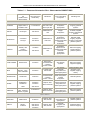
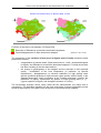
1
couverture_roselt-ang.qxd
03/04/2004
10:10
Page 1
LONG TERM ECOLOGICAL MONITORING
OBSERVATORIES NETWORK
LONG TERM ECOLOGICAL MONITORING
OBSERVATORIES NETWORK
ROSELT/OSS
ROSELT/OSS
ROSELT/OSS
TNERS
ROSELT/OSS PAR
PARTNERS
AFRICAN COUNTRIES INVOLVED
INVOLVED
Algeria :
Centre de Recherche Scientifique et Technique sur les Régions Arides (CRSTRA, Biskra), URBT/UST, Alger
Cap verde :
Instituto Nacional de Investigaçao E Desenvolvimento Agrario (INIDA), Praia
Egypt :
Departement of botany, faculty of science, University of Alexandria
Ethiopia :
Pastoral Unit, Ministry of Agriculture, Addis Abeba
Kenya :
Minitry of Water Resources, Development and Management, Nairobi
Mali :
Institut d’Economie Rurale (IER), Bamako
Marocco :
Division de Recherche et d’Experimentations Forestières (DREF), Rabat
Mauritania :
Direction de l’Environnement et de l’Aménagement Rural (DEAR), Nouakchott
Niger :
Ministère de l’Hydraulique, de l’Environnement et de la Lutte Contre la Désertification, Niamey
Senegal :
Centre de Suivi Ecologique (CSE), Dakar
Tunisia :
Institut des Régions Arides (IRA), Médenine
A COMMON DEVICE FOR THE MONITORING
OF DESER TIFICATION
IN CIRCUM-SAHARAN AFRICA
EXTENSION
Ouganda :
Ministry of Water Lands and Environment, Kampala
Chad :
Ministère de l’Environnement et de l’Eau, N’djamena
Burkina Faso : Institut National de l’Environnement et des Recherches Agricoles (INERA), Ouagadougou
Libya :
ACHIEVEMENTS AND RESTROSPECTIVE OVER VIEW
Libyan Center for Remote Sensing and Space Sciences (LCRSSS), Tripoli
REGIONAL OPERATOR
OPERATOR
Leader
Switzerland
FINANCIAL PAR
TNERS
PARTNERS
Italia
France
DDc-Switzerland
ASSOCIATED
TNERS
ASSOCIATED PAR
PARTNERS
UNESCO
EU
CeSia
ISBN: 9773-856-08-2
Tél. : 216 - 71 206 633
.
Observatoire du Sahara et du Sahel
Boulevard du Leader Yasser Arafat - BP 31, 1080 Tunis Cedex, Tunisie
71 206 634 Fax. : 216 - 71 206 636
E-mail : [email protected]
URL : www.unesco.org/oss
.
.
S A H A R A A N D S A H E L O B S E R VAT O R Y
L
LO
ON
NG
GT
TE
ER
RM
ME
EC
CO
OL
LO
OG
GIIC
CA
AL
LM
MO
ON
NIIT
TO
OR
RIIN
NG
G
O
OB
BS
SE
ER
RV
VA
AT
TO
OR
RIIE
ES
SN
NE
ET
TW
WO
OR
RK
K
R
RO
OS
SE
EL
LT
T//O
OS
SS
S
A
A CCO
OM
MM
MO
ON
ND
DEEV
VIICCEE FFO
OR
R TTH
HEE M
MO
ON
NIITTO
OR
RIIN
NG
G
O
OFF D
DEES
SEER
RTTIIFFIICCA
ATTIIO
ON
N
IIN
N CCIIR
RCCU
UM
M –– S
SA
AH
HA
AR
RA
AN
NA
AFFR
RIICCA
A
A
AC
CH
HIIE
EV
VE
EM
ME
EN
NT
TS
SA
AN
ND
DR
RE
ES
ST
TR
RO
OS
SP
PE
EC
CT
TIIV
VE
EO
OV
VE
ER
RV
VIIE
EW
W
st
1 edition
- MARCH 2004 -
Sahara And Sahel Observatory
© 2004/ Sahara And Sahel Observatory (OSS)
ISBN: 9773-856-08-2
Observatoire du Sahara et du Sahel
Boulevard de l’Environnement – BP 31 Tunis Cedex, Tunisie
Tel. + 216 71 806 522 – Fax. + 216 71 807 310
E-mail: [email protected] - URL: www.unesco.org/oss
ACKNOWLEDGEMENTS
iii
A
AC
CK
KN
NO
OW
WLLE
ED
DG
GE
EM
ME
EN
NT
TS
S
After 10 years of life of the network, a special tribute is due to Mr. Gilbert LONG, Honorary Research
Director at CNRS (National Scientific Research Centre), former President of the MAB-France
Committee, and President of the Scientific and Technical Committee (STC) of ROSELT/OSS (Long Term
Ecological Monitoring Observatories Network/Sahara and Sahel Observatory), for the unfailing support
he has generously provided to OSS throughout these years and for making his experience available to
OSS, particularly by laying the conceptual bases for the design of the network and then directing the
ROSELT/OSS programme through to its operational implementation.
As early as 1994, the OSS Executive Secretariat was enjoying the support of several men of science
and field experts, both from the North and from the South. In this regard, OSS would like to thank in
particular the small Orientation Committee composed, at the time, of Mr. Mohamed SKOURI, former
international expert to UNESCO and Vice-President of the ROSELT/ OSS Scientific and Technical
Committee, Mr. Jean Claude MENAUT (Ecole Normale Supérieure de Paris, CESBIO Director, Toulouse)
and Mr. Antoine CORNET, former President of the French Scientific Committee on Desertification,
Representative of IRD in Tunis (Tunisia), as well as all members of the former OSS Scientific and
Technical Committee (now replaced by the Strategic Orientation Committee), namely :
Mr. Michel HOEPFFNER, IRD-MEDIAS, Toulouse (France);
Mr. Klaus MUELLER-HOHENSTEIN, Professor at the University of Bayreuth (Germany) and
member of the Scientific and Technical Committee (STC) -ROSELT/OSS;
Mr. Jesse Theuri NJOKA, Professor at the University of Nairobi (Kenya), member of the STCROSELT/OSS and Regional ROSELT/OSS Coordinator for East Africa.
Besides, several international experts have contributed in developing the ROSELT/OSS network, and
special thanks are due to :
Mr. Mohamed AYYAD, the late Professor at the University of Alexandria (Egypt) and former
member of the STC-ROSELT/OSS;
Mr. Bertrand de MONTMOLLIN, Director of BIOLConseils (Neuchâtel, Switzerland) and member
of the STC-ROSELT/OSS;
Mr. Giuseppe ENNE, Professor at the Faculty of Cagliari (Sardinia) and member of the STCROSELT/OSS;
Mr. Mounkaila GOUMANDAKOYE, Team Leader, Regional Office for Central and West Africa at
UNDP;
Mr. Hamid NARJISSE, Professor at IAV Hassan II and Director General of INRA (Morocco);
Mr. Edouard LE FLOC’H, Research Engineer at CNRS (France);
Mr. Ahmed AIDOUD, Consultant, Teacher at the University of Rennes (France);
Mr. Jean Claude BILLE, Honorary Research Director at IRD (France);
Mr. Andrea di VECCHIA, IATA-CNR (Florence, Italy);
Mr. Francis FOREST, CIRAD (France);
Mr. Christian FLORET, Honorary Research Director at CNRS, Dakar (Senegal);
M. Ibrahima A. TOURÉ, the late former Coordinator of FAPIS and RCS / Sahel projects.
OSS would also like to thank all those officials of institutions that have acted as Regional Operators,
expressing gratitude to Mr. Alain GERBE (former IARE Director) and to all the members of the Regional
Operator Consortium composed of IRD (group leader), of CIRAD and of CILSS/INSAH, with a particular
mention for their representatives within this Consortium, namely :
Mr. Jean Marc D’HERBÈS, Regional Coordinator and Mr. Joseph BOULÈGUE, Director of Earth
and Environment Department (DME) at IRD;
iv
ACKNOWLEDGEMENTS
Mr. Bernard TOUTAIN, ROSELT/OSS Sub-regional Coordinator for East Africa (Nairobi, Kenya),
Mr. Joseph DOMENECH, Director of Stock-breeding and Veterinary Medicine Department
(Elevage et Médecine Vétérinaire EMVT), Mr. François MONICAT, Programme Manager;
Mr. Idriss ALFAROUKH, Director of INSAH and Mr. Netoyo LAOMAÎBAO and Khassoum DIEYE
from the INSAH Research Department, as well as Mr. Gaoussou TRAORE and Mr. Sibiri
OUEDRAOGO who have consecutively served as Sub-regional Coordinator for West Africa;
Mr. Musa MBENGA, CILSS Executive Secretary, for his unfailing support to OSS and its
programmes.
The operating of the network could not have run so smoothly without the contribution of the national
teams and, in particular, that of the national correspondents :
Mr. Abdelaziz GAOUAR, General Director of CRSTRA, Biskra (Algeria) ;
Mr. Koudier MEDIOUNI, the late Scientific Coordinator of the Observatory of the Steppes of the
Upper Plains of the South West of Oran, URBT, Algiers (Algeria) ;
Mrs. Dalila NEDJRAOUI, Scientific Coordinator of the Observatory of the Steppes of the Upper
Plains of the South West of Oran, URBT, Algiers (Algeria) ;
Mr. Mohamed ABDELRAZIK, Professor at the University of Alexandria, National and Scientific
Coordinator of the Observatory of El Omayed (Egypt) ;
Mr. Abderrahmane KABBAJ, Director of DREF, Rabat (Morocco) ;
Mr. Mohamed YASSIN, National and Scientific Coordinator of the Observatory of Oued Mird,
DREF, Rabat (Morocco) ;
Mr. Abdelouahed EL GHARBAOUI, Director of ORMVAO (Morocco) ;
Mr. Ahmed RAMDANE,
ORMVAO (Morocco) ;
Scientific
Coordinator
of
the
Observatory
of
Issougui,
Mr. Houcine KHATTELI, National Coordinator, Director General of IRA, Medenine (Tunisia) ;
Mr. Mongi SGHAIER, Scientific Coordinator of the Observatory of Menzel Habib, IRA, Medenine
(Tunisia) ;
Mr. Rachid BOUKCHINA, Scientific Coordinator of the Observatory of Haddej Bou Hedma, IRA,
Gabes (Tunisia) ;
Mr. Antonio EVORA FERREIRA QUERIDO, National ROSELT Coordinator, President of INIDA, Praia
(Cape Verde) ;
Mr. Joe SPENCER, Scientific Coordinator of the Observatory of Ribeira Seca, INIDA, Praia (Cape
Verde) ;
Mr. Bino TEME, Director General of IER, Bamako (Mali) ;
Mr. Fadiala DEMBELE, National and Scientific Coordinator of the Observatory of Bamba (Bourem
Circle), IER, Gao (Mali) ;
Mr. Mohamed OULD HAMZA, National and Scientific Coordinator of the Observatory of
Nouakchott (Mauritania) ;
Mr. Wata ISSOUFOU, National ROSELT Coordinator, MHELCD, Niamey (Niger) ;
Mr. Maxime BANOIN, Scientific Coordinator of the Observatory of Torodi (Torodi-TondikandiaDandiantou observatories set), University of Niamey (Niger) ;
Mr. Aboubacar ICHAOU, Scientific Coordinator of the Observatory of Dandiantou (TorodiTondikandia-Dandiantou observatories set), MHELCD, Niamey (Niger) ;
Mr. Moktar NIANG, Director General of CSE, Dakar (Senegal) ;
ACKNOWLEDGEMENTS
v
Mr. Magatte BA, National and Scientific Coordinator of the Observatory of Ferlo, CSE, Dakar
(Senegal) ;
Mr. Fred MWANGO, National ROSELT Coordinator, MWRMD, Nairobi (Kenya).
During these years, several young competencies have participated in the development of ROSELT/OSS,
within the Executive Secretariat team and the Regional Coordination team, namely : Wafa ESSAHLI,
Mohamed EL GUERROUJ, Sandrine JAUFFRET, Maud LOIREAU, Cécile FONTANA, Jean-Christophe
DESCONNETS, Eric DELAITRE and Olivia DELANOË…
Last but not least, we would like to commend the unfailing support of our financial partners that have
allowed the development of the network. OSS is pleased to express its immense gratitude to the French
Ministry for Foreign Affairs (MAE), the Ministry of Ecology and Sustainable Development (MEDD), the
French Fund for World Environment of the French Development Agency (FFEM/AFD), to the Directorate
of Development and Cooperation of the Swiss Federal Department of Foreign Affairs (DDC), as well as
to the Italian Cooperation Agency and the German Cooperation Agency.
OSS finally acknowledges the highly beneficial decision for this project consisting in setting up, within
IRD, of a « Desertification » Service Unit, and expresses warmest thanks to IRD General Director.
A special tribute is due to Marc BIED CHARRETON, former Executive Director of OSS and President of
the French Scientific Committee on Desertification – France, to have initiated this great African
programme.
SYNTHESIS
vii
S
SY
YN
NT
TH
HE
ES
SIIS
S
CCOON
NTTEEXXTT A
AN
NDD OORRIIGGIIN
N OOFF TTH
HEE CCOON
NCCEEPPTT OOFF LLOON
NGG TTEERRM
M EECCOOLLOOGGIICCA
ALL
M
MOON
NIITTOORRIIN
NGG
Following the intense and recurrent droughts that had prevailed in sub-Saharan Africa in the mid1960s, political awareness and the mobilisation of the scientific community toward checking the
desertification processes and mitigating drought effects have brought about the need to monitor and
evaluate the natural resources in order to ensure their sustainable management. This has led to
conducting several studies and research works on droughts and aridity, as well as on their ecological
implications (soil degradation, desertification) and socio-economic impacts (migration, rural exodus,
pauperisation). This period was characterised by the adoption of the action plan to combat
desertification which was developed during the United Nations Conference on Desertification (Nairobi,
Kenya, August/September 1977) and the coming into force of the United Nations Convention to Combat
Desertification (CCD). This convention—a strategy in its own right—strongly emphasises the
development of scientific and technical cooperation among the relevant institutions at national, subregional, regional and international level.
In this regard, the establishment of the Sahara and Sahel Observatory (OSS) in 1992, has favoured the
emergence of a new North-South-South partnership and solidarity spirit, as well as the development of
new synergies between the various partners, thus allowing the capitalisation of acquired knowledge and
experience, the harmonisation of data collection and analysis methods, information sharing and the
design of new tools to help in decision making.
In view of these considerations, and based on the conclusions and recommendations of a workshop
organised jointly with UNESCO and the International Geosphere-Biosphere Programme (IGBP) in July
1992 in Fontainebleau (France) on continuous monitoring of terrestrial ecosystems, OSS proposed the
set up of a Long Term Ecological Monitoring Observatories Network (ROSELT/OSS) whose objective would
be to better apprehend the causes and effects of desertification in the circum-Saharan African region.
This initiative constitutes a response to the need expressed by the Southern member countries to
access reliable data on the state of the environment, and more particularly in circum-Saharan arid and
semi-arid zones that are severely hit and/or endangered by desertification. Ecological monitoring is
understood in its broadest sense, namely the study of the dynamics of the natural, physical and
biological environment, of the human environment, including social organisation, the dynamics of land
use systems, as well as the dynamics of the interactions that exist between these various sets.
FFRROOM
M DDEESSIIGGN
N TTOO A
AN
N OOPPEERRA
ATTIIOON
NA
ALL IIM
MPPLLEEM
MEEN
NTTA
ATTIIOON
N OOFF TTH
HEE RROOSSEELLTT//OOSSSS
PPRROOGGRRA
AM
MM
MEE
Between 1992 and 1994, the inventory of
Potential Candidate Territories (TCP)—which had
been conducted by the countries—allowed an ad
hoc Scientific Committee to select, based on
labellisation criteria, 25 observatories or
observatory clusters, distributed over 11
countries. Among these 25 ROSELT/OSS
observatories, 12 were further selected as pilotobservatories, intended to serve—within a first
phase—as a basis for refining the concept,
finalising the techniques and methodologies of
data collection and processing, and developing
reliable, relevant and reproducible tools to help in decision-making (maps, indicators, information
systems . . .).
viii
SYNTHESIS
In the light of these works, the founding document of the ROSELT/OSS was drafted in 1995 and synthesis
studies providing « a reference state » in three North-African pilot-observatories (1996-1997) were
conducted. A first operational phase was subsequently launched in 1998 in order to perform in situ
testing of the data collection and processing methods.
The insufficient integration between the devices used for the sampling of biophysical and socio-economic
parameters based on the sectorial approach adopted during this phase did not allow the development of
the expected tools to help in decision making.
The launch of the ROSELT/OSS in West
Africa in June 2000 during the Bamako
workshop led to updating the concepts
used within the network and to adopting a
comprehensive conceptual outline for the
study of environmental changes within the
ROSELT/OSS. The « landscape » thus
developed allows the integration of the
whole set of biophysical and socioeconomic data and the study of the impact
of uses on the natural resources, and this
with a view to developing products that
help in decision making, such as reliable
data on soil degradation in arid zones,
biophysical and socio-economic indicators,
state of the environment of the OSS
region,
spatialised
resources/uses
balances, prospective scenarios . . .
Particular effort was made in order to
define a minimum data set, to be collected
at lower cost, and which would allow the spatialisation of data, their possible extrapolation to larger
zones and their integration within models of use of both space and resources.
TTH
HEE RROOSSEELLTT//OOSSSS PPRROODDUUCCTTSS :: DDEEVVEELLOOPPM
MEEN
NTT,, UUSSEE A
AN
NDD DDIISSSSEEM
MIIN
NA
ATTIIOON
N
The ROSELT/OSS products may be distributed as follows :
o
Previous achievements : development of reference states under the form of thematic maps,
such as « land use » maps, and « physical features » maps (pedology, geomorphology . . . );
o
The scientific and technical documents which are gradually issued as part of the « ROSELT/OSS
Scientific and Technical Collection », such as the methodological guidebook and its thematic
leaflets (including Vegetation, Socio-economic Features, Fauna...), the national scientific and
technical reports;
o
The Local Environment Information System LEIS - ROSELT/OSS;
o
The metadata base;
o
The Charter on the management and
dissemination of data and products
within ROSELT/OSS;
o
The indicators at local and regional
levels;
ROSELT/OSS Observatory of « Banizoumbou » – Niger
o
The prospective simulations
desertification risk index maps.
and
Coordinates : UTM Million m
Villages
Coordinates : UTM Million m
Villages
Desertification
Risk
Index (IRD) (IRD)
Indice
de Risque de
Désertification
Desertification
Risk
Index (IRD) (IRD)
Indice
de Risque de
Désertification
On iron pancuirassés
plateaux
Sur plateaux
(pastoral
and forestry
uses)
(Usages
On iron et
panforestier)
plateaux
Surpastoral
plateaux
cuirassés
(pastoral
and forestry
uses)
(Usages
pastoral
et
forestier)
Very faible
Low
[0-10] : Très
Very
Low
]10-17]
faible
Very
Low
[0-10]: Très
: Très
faible
Medium
]17-34]
: Faible
Very Low
]10-17]
: Très
faible
Medium
]17-34]
:
Faible
Outplateaux
of iron pancuirassés
plateaux
Hors
(agricultural, pastoral and forestry
(Usages
agricole,
et
Out
of iron pastoral
pancuirassés
plateaux
Hors
plateaux
uses)
(agricultural,
pastoral and forestry
forestier)
(Usages
agricole,
pastoral et
uses)
Very
Low
[0-17]forestier)
: Très
faible
Very
Low
]17-34]
[0-17]: Faible
:Low
Très
faible
Medium
Low
]34-56]
: Moyen
]17-34]
: Faible
High
Medium
]56-81]
: Fort
]34-56]
: Moyen
Very
high
High
]81-100]
fort
]56-81]: Très
: Fort
Very high
]81-100] : Très
fort
Degraded zones
Zones dégradées
Degraded zones
Zones dégradées
IRD = ISSD * IP
* (D_USR
IP = (P_USRAi / P_USR
IRD =
* IP / D_USRA)
A)ISSD
IP = (P_USRAi / P_USRA) * (D_USR / D_USRA)
SYNTHESIS
ix
The relevance of the concept of ecological monitoring and of the products developed by the network have
persuaded a large number of the countries involved in the network as to the need to boost the
development of environmental monitoring on the level of the countries. Indeed, the ROSELT/OSS has
already been integrated in the NAP/CCD of several countries (Algeria, Mali, Morocco, Niger, Tunisia)
and is in process of integration in the NAP/CCD of Egypt and of Kenya. The ROSELT/OSS methodologies
are adapted and replicated in the framework of implementation of the national environmental monitoring
devices (Niger, Mali) which are either based on, or which integrate, environmental monitoring
observatories, such as the ROSELT/OSS observatories.
Besides, Morocco and Tunisia1 have undertaken to conduct two studies in order to assess the state of
the art in the field of monitoring-evaluation of desertification (research projects, development
projects...) and to use the results acquired for purposes of proposing an overall framework for an
operational implementation of the NAP/CCD monitoring-evaluation systems. The substantial contribution
of the ROSELT/OSS has been largely underscored, particularly with regard to control over the
desertification process and to the promotion of development support actions. The results already
obtained by the ROSELT/OSS in Tunisia (indicators, prospective simulations deriving from the LEISROSELT/OSS and desertification risk index map) will be gradually displayed on the Tunisian site of the
System of Information Sharing on Desertification and the Environment (SCIDE, updated in the framework
of the SMAP project). More specific studies on the national environmental monitoring devices have been
conducted in Algeria2, Egypt3 and Morocco4 ; they are in process of validation by the National
Coordination Institutions (ONC) in these countries.
It is worth pointing out that the data and metadata bases in process of establishment in each of the
member countries of the network represent a major asset for the countries in the field of management
and dissemination of data that help in decision making.
Finally, the whole set of the products developed and of the results obtained are regularly presented
during international events (colloquia, seminars . . . ) and on the occasion of the Conferences of the
Parties to the United Nations Convention to Combat Desertification (UNCCD). The information
dissemination tools (web sites, brochures, posters...) are regularly updated in order to provide updated
information to the various categories of stakeholders concerned by combating desertification.
RROOSSEELLTT//OOSSSS :: A
AN
NA
ASSSSEETT FFOORR TTH
HEE SSEETT UUPP OOFF N
NA
ATTIIOON
NA
ALL EEN
NVVIIRROON
NM
MEEN
NTTA
ALL
M
O
N
I
T
O
R
I
N
G
D
E
V
I
C
E
S
MONITORING DEVICES
The ROSELT/OSS programme is a complex, ambitious and exacting programme. It is complex, since it
sets out to study not only the state of the dynamics of the ecological and socio-economic systems and
their interactions, but also the causes and consequences of soil degradation. It is ambitious, since it
seeks to bring concrete and practical answers to issues of development and of environmental protection
in areas where the scarce resources are vulnerable. And it is exacting, since it requires several
scientific specialities, team work within multi-disciplinary and inter-disciplinary teams, calling upon the
contribution of the whole range of the stakeholders involved in combating desertification (planners,
developers and development officials in general, including the populations concerned), and this within
the framework of a participatory approach. Yet the ROSELT/OSS remains for all that an absolutely
necessary programme to address the concern for monitoring and evaluation of the phenomena of
degradation and, where necessary, to provide the countries with reliable and relevant data that can be
generalised and/or extrapolated, and which are generated by the close interdependence between
environment and sustainable development. To address this concern, only the set up of long term
ecological monitoring devices would help to provide an answer.
1
On the occasion of the launch workshops of the SMAP project for « Setting up a monitoring-evaluation system in the Maghreb » held in Rabat
(on 28 and 29 November 2002) and in Tunis (on 22 and 23 April 2003).
2
Les mécanismes de suivi de la désertification en Algérie. Proposition d’un dispositif national de surveillance écologique à long terme en
Algérie (Mechanisms for the monitoring of desertification in Algeria : Proposal for a National Long Term Ecological Monitoring device in
Algeria), Pr. Dalila Nedjraoui.
3
Mechanisms for Monitoring the Desertification at the National Level of Egypt, Pr. Mohamed Abdelrazik
4
Projet de conception d’un dispositif national de surveillance écologique au Maroc, (Conceptual project of ecological monitoring national device
in Morocco), Mohamed Yassin.
SYNTHESIS
x
However, while the long term vision of land use planning and the management of resources represents
an attractive conceptual framework, its implementation needs to overcome several obstacles which the
ROSELT/OSS has not been spared. Indeed, ecological monitoring requires fairly considerable human and
material means, as well as stable and sound institutions. However, such conditions are often difficult to
find in developing countries, particularly in Africa. The lack of synergy between the national institutions
has often proved to be an impediment to a proper progress of the programme and has induced, at its
inception, a slackening of the pace of the implementation of its activities. Much effort had to be invested
in order to get the message across to the institutions concerned that the OSS is not a funding agency
and that the means that they provide need, on the one hand, to incept a national effort in this regard
and, on the other hand, to build up the teams and the institutions involved. The implementation of this
unusual approach has been arduous, resulting in certain cases in delays due to the insufficiency of the
means provided in view of the efforts required.
Yet, in spite of such handicaps, which seem a priori to be difficult to overcome, the ROSELT/OSS
programme was launched and it became established in several OSS member countries. This inception
phase has been, above all, a phase of training, set up of teams and finalisation from a conceptual and
methodological point of view. The active work of the network, the exchanges between the members, not
to forget the strengthening of the North-South partnership and the building of national capacities have
made it possible to extend, to the countries of the South, the methodological and technological
developments indispensable for a mastery over the dissemination of information that help in decision
making. Concrete results have thus been achieved in the past 4 years. The tools (data and metadata
bases, Local Environment Information Systems (LEIS) and products developed by the network already
contribute in :
o
the harmonisation of the data collection and processing methods (methodological guidebooks) ;
o
the development of a diagnosis of the state of desertification in the circum-Saharan zones of
the OSS region ;
o
the definition of a specific minimum data set for each « observatory » and the minimum set of
data common to the « network » which need to be collected at lower cost with a view to
developing specific and necessary indicators on the local and regional levels.
The dynamics that has developed within the network, the appropriation of the ROSELT/OSS
methodologies and of long term environmental monitoring by the national institutions, the drafting of a
charter on the management and dissemination of data within the network, and the gradual
implementation of computer tools constitute a major step toward the strengthening of the network and
its integration within the national environmental monitoring devices.
The ROSELT/OSS programme constitutes an additional asset for African countries and for the subregional and regional institutions in combating desertification and in mitigating drought effects, and in
particular as a key component of the national environmental monitoring devices, which themselves
constitute the major pillars of the monitoring-evaluation of the NAP/CCD.5 Accordingly, the OSS does
not spare any effort to clarify and further the debate on the concept of monitoring evaluation and to
make visible the contribution of the ROSELT/OSS in the implementation of development and
environmental protection programmes. The products that help in decision making which are gradually
developed in the framework of the ROSELT/OSS programme will be made available to the NAP/CCD
Monitoring-Evaluation Systems that are gradually set up, particularly in Tunisia and in Morocco, in the
context of the implementation of the conventions on combating desertification and on biological
diversity.
On the international and European level, the ROSELT/OSS now emerges as an indispensable African
network in the field of ecological monitoring. The North-South scientific rooting of the network has been
considerably strengthened, particularly thanks to the set up of a ROSELT/OSS specific
« Desertification » Service Unit within the Research Institute for Development (IRD, formerly ORSTOM)
5
Such as recommended by the CCD, and designed by the OSS and its partners : The CILSS, UMA and 7 African pilot countries, which have
been joined by GRULAC and China in the framework of a working group that was set up following a recommendation by the CoP4.
SYNTHESIS
xi
and to the involvement of the ROSELT/OSS programme in the draft applications eligible to the European
Commission. These initiatives are likely to promote scientific cooperation on desertification among the
specialised institutions from both North and South and will help toward the sustainability of the network
and the mobilisation of the means allotted to this complex issue.
Monitoring-Evaluation (M&E) of NAP and SRAP to combat desertification
LIST OF ROSELT/OSS PRODUCTS
xiii
LLIIS
ST
TO
OFF R
RO
OS
SE
ELLT
T//O
OS
SS
SP
PR
RO
OD
DU
UC
CT
TS
S
Beside all publications mentionned in references, the ROSELT/OSS products may be distributed as
follows :
o
Previous achievements : development of reference conditions under the form of thematic
maps, such as « land use » maps, and « physical features » maps;
o
The scientific documents which are gradually issued as part of the « ROSELT/OSS Scientific
and Technical Collection », such as :
the methodological guidebook and its thematic leaflets (such as flora and
vegetation, socio-economic features, fauna, . . . );
technical and concept-related documents;
national scientific and technical reports;
o
Local Environment Information System LEIS - ROSELT/OSS;
o
The metadata base;
o
The Charter on the management and dissemination of data and products within
ROSELT/OSS;
o
Indicators at local and regional levels;
o
Prospective simulations and desertification risk index maps.
The products are proposed in more detail in § 4.
RROOSSEELLTT//OOSSSS SSCCIIEEN
NTTIIFFIICC A
AN
NDD TTEECCH
HN
NIICCA
ALL CCOOLLLLEECCTTIIOON
N
SSCCIIEEN
NTTIIFFIICC DDOOCCUUM
MEEN
NTTSS
ROSELT/OSS 1995. Document Scientifique 1 : Conception, organisation et mise en oeuvre de ROSELT.
Collection ROSELT/OSS, première parution en 1995, nouvelle édition 2004.
ROSELT/OSS 1995. Scientific Document 1: Conceptual, organizational and operational framework of
ROSELT/OSS. Collection ROSELT/OSS, first edition in 1995, new edition 2004.
ROSELT/OSS, 2004. Document Scientifique 2 : ROSELT/OSS : Organisation, Fonctionnement et
Méthodes de ROSELT/OSS. Édition 2001, révisée 2004.
ROSELT/OSS, 2004. Scientific Document 2 : ROSELT/OSS : Organisation, Operation and Methods,
Edition 2001, revised in 2004.
ROSELT/OSS, 2004. Document Scientifique 3 : Concepts et méthodes du SIEL – ROSELT (Système
d’Information sur l’Environnement à l’Échelle Locale).
ROSELT/OSS, 2004. Scientific document 3 : Concepts and methods of ROSELT LEIS (Local Environment
Information System).
ROSELT/OSS, 2004. Document Scientifique 4 : Indicateurs écologiques ROSELT/OSS. Une première
approche méthodologique pour la surveillance de la biodiversité et des changements environnementaux.
(Scientific Document 4 : ROSELT/OSS ecolological indocators. A frst methodological apporach for the
monitoring of biodiversity and environmental changes).
TTEECCH
HN
NIICCA
ALL CCOON
NTTRRIIBBUUTTIIOON
NSS
ROSELT/OSS, 2004. Contribution Technique n°13 : Etat comparé de l’environnement dans les
observatoires ROSELT/OSS du Maghreb. (Technical Contribution n°13 : Comparative State of the
Environment in the ROSELT/OSS Observatories of the Maghreb).
ROSELT/OSS, 2004. Contribution Technique 1 : Guide ROSELT/OSS pour l’évaluation et la surveillance
de la végétation. (ROSELT/OSS Guidebook for the Assessment and Monitoring of Vegetation).
LIST OF ROSELT/OSS PRODUCTS
xiv
ROSELT/OSS, 2004. Contribution Technique 2 : Guide ROSELT/OSS pour l’évaluation et le suivi des
pratiques d’exploitation des ressources naturelles. (Technical Contribution 2 : ROSELT/OSS Guidebook
for the Assessment and Monitoring of uses of natural resources).
ROSELT/OSS, 2004. Contribution Technique 3 : Manuel d’utilisation de l’outil SIEL - ROSELT (version
1.3). (Technical Contribution 3 : Instructions Manual for LEIS in ROSELT/OSS ( version 1.3)).
ROSELT/OSS, 2004. Contribution technique 4 : Application des indicateurs écologiques de la
dégradation des terres à l'observatoire de Menzel Habib (TUNISIE). (Technical Contribution 4 :
Application of Ecological Indicators of Land Degradation in the Observatory of Menzel Habib (Tunisia)).
ROSELT/OSS, 2004. Technical contribution 5 : Surveillance of ecological changes in the ROSELT/OSS
observatory of El Omayed (EGYPT) : first results.
ROSELT/OSS, 2004. Contribution Technique 6 : Recherche des indicateurs de changement écologique
et de la biodiversité dans l’observatoire de Oued Mird (MAROC) / : premiers résultats. (Technical
contribution 6 : Research of ecological indicators changes and of biodiversity in the Oued Mird
Observatory (MOROCCO) : first results).
ROSELT/OSS, 2004. Contribution Technique 7 : Surveillance des changements écologiques dans
l’observatoire ROSELT/OSS de Haddej – Bou Hedma (TUNISIE) : premiers résultats. (Technical
contribution 7 : Monitoring of ecological changes in the ROSELT/OSS Observatory of Haddej Bou Hedma
(TUNISIA) : first results).
ROSELT/OSS, 2004. Contribution Technique 8 : Espaces-ressources-usages : première application du
Système d’Information sur l’Environnement à l’échelle Locale sur l’observatoire ROSELT/OSS de
Banizoumbou (NIGER). (Technical Contribution 8 : Space – resources – uses : first application of the
Local Environment Information System in the ROSELT/OSS Observatory of Banizoumbou (NIGER)).
ROSELT/OSS, 2004. Contribution Technique 9 : Recherche d’indicateurs de désertification par analyse
comparative de quelques observatoires ROSELT/OSS. (Technical contribution 9 : Development of
Desertification Indicators by Comparative Analysis of a Few ROSELT/OSS Observatories).
ROSELT/OSS, 2004. Contribution Technique 10 : Une approche spatiale pour la surveillance de la faune
- Etude de cas au Sud du Maroc : la vallée de l’oued Mird. (Technical Contribution 10 : A spatial
approach for the Monitoring of the Fauna. Case Study in Southern Morocco : The Valley of Oued Mird).
ROSELT/OSS, 2004. Contribution Technique 11 : Guide ROSELT/OSS pour l’évaluation et la surveillance
des États de surface et des sols. (Technical Contribution 11 : ROSELT/OSS Guidebook for the
Assessment and Monitoring of the Surface State and Soils).
ROSELT/OSS, 2004. Contribution Technique 12 : Système de circulation de l’information ROSELT/OSS :
Définition des métadonnées et élaboration des catalogues de référence. . (Technical Contribution 12 :
ROSELT/OSS Information Circulation System : definition of metadata and development of reference
catalogue).
ROSELT/OSS, 2004. Contribution Technique 13 : Guide ROSELT/OSS pour la cartographie dynamique
de la végétation et des paysages. (Technical Contribution 13 : ROSELT/OSS Guidebook for the dynamic
cartography of vegetation and of landscape).
ROSELT/OSS, 2004. Contribution Technique 14 : Fiches Techniques pour la construction des
indicateurs écologiques ROSELT/OSS. (Technical Contribution 14 : Technical Cards for the development
of ROSELT/OSS ecological indicators).
ROSELT/OSS, 2004. Contribution Technique 15 : Synthèse comparative de quatre années de
surveillance environnementale sur trois observatoires ROSELT/OSS du Nord de l’Afrique : El Omayed,
Haddej Bou Hedma et Oued Mird. (Technical Contribution 15 : Comparative synthesis of four years of
environmental monitoring within three ROSELT/OSS observatories of North Africa : El Omayed, Haddej
Bou Hedma and Oued Mird).
A
A CCO
OM
MM
MO
ON
ND
DEEV
VIICCEE FFO
OR
R TTH
HEE M
MO
ON
NIITTO
OR
RIIN
NG
G
O
OFF D
DEES
SEER
RTTIIFFIICCA
ATTIIO
ON
N
IIN
N CCIIR
RCCU
UM
M –– S
SA
AH
HA
AR
RA
AN
NA
AFFR
RIICCA
A
A
AC
CH
HIIE
EV
VE
EM
ME
EN
NT
TS
SA
AN
ND
DR
RE
ES
ST
TR
RO
OS
SP
PE
EC
CT
TIIV
VE
EO
OV
VE
ER
RV
VIIE
EW
W
CONTENTS
3
CONTENTS
LIST OF ABBREVIATIONS.....................................................................................................5
ROSELT/OSS SCIENTIFIC AND TECHNICAL COLLECTION .......................................... XIII
SCIENTIFIC DOCUMENTS ......................................................................................................... XIII
TECHNICAL CONTRIBUTIONS ................................................................................................... XIII
1- CONTEXT AND ORIGIN OF THE CONCEPT OF LONG TERM ECOLOGICAL
MONITORING .....................................................................................................................7
2- THE LONG TERM ECOLOGICAL MONITORING OBSERVATORIES NETWORK
(ROSELT/OSS)...................................................................................................................9
3- GENERAL PRINCIPLES OF ORGANISATION AND OPERATING OF ROSELT/OSS...11
3.1- THE CHOICE OF SITES .......................................................................................................11
3.2- THE NETWORK EFFECT......................................................................................................14
3.3- ACTIVITIES PROGRAMME AND OBJECTIVES .......................................................................14
3.3.1. A MODEL ACTIVITIES PROGRAMME SINCE 1998 ...............................................................14
3.3.2. A NEW CONCEPTUAL MODEL FOR PROGRAMMING ACTIVITIES AS FROM THE YEAR 2000 ...15
4- PRODUCTS .......................................................................................................................19
4.1- SUMMARY OVERVIEW OF PAST ACHIEVEMENTS ..................................................................19
4.2- METHODOLOGICAL TOOLS AND BASES ..............................................................................21
4.2.1. THE METHODOLOGICAL GUIDEBOOK..............................................................................21
4.2.2. THE CONCEPTUAL AND TECHNICAL DOCUMENTS .............................................................22
4.2.3. THE SCIENTIFIC AND TECHNICAL REPORTS ......................................................................23
4.2.4. THE LEIS-ROSELT/OSS ..............................................................................................24
4.2.5. THE METADATA BASE .....................................................................................................25
4.2.6. THE CHARTER ON TO THE MANAGEMENT AND DISSEMINATION OF DATA AND PRODUCTS...25
4.3- METHODOLOGICAL BASES AND TRAINING ..........................................................................26
4.4- THE INDICATORS ...............................................................................................................27
4.4.1. INDICATORS OF ENVIRONMENTAL CHANGES AND DESERTIFICATION ON THE LOCAL SCALE 27
4.4.2. SYNTHETIC INDICATOR ON REGIONAL SCALE ...................................................................32
4.4.3. PROSPECTIVE SIMULATIONS AND DESERTIFICATION RISK INDEX.......................................33
5- INTEGRATION OF ROSELT/OSS IN THE NAP/CCD (NATIONAL ACTION
PROGRAMME TO COMBAT DESERTIFICATION) AND USE OF ITS PRODUCTS BY
THE NETWORK MEMBER COUNTRIES ........................................................................37
6- COMMUNICATION AND DISSEMINATION OF ROSELT/OSS PRODUCTS ..................39
7- CONCLUSIONS.................................................................................................................41
BIBLIOGRAPHICAL REFERENCES ....................................................................................45
CONTENTS
4
DOCUMENTS AND REPORTS DEVELOPED AT REGIONAL LEVEL ...................................................45
DOCUMENTS AND REPORTS DEVELOPED BY THE COUNTRIES .....................................................46
PROCEEDINGS OF SYMPOSIA AND WORKSHOP REPORTS ...........................................................48
POSTERS AND BROCHURES ROSELT/OSS ..............................................................................49
OTHER REFERENCES................................................................................................................49
5
LIST OF ABBREVIATIONS
LIST OF ABBREVIATIONS
AFD
Agence Française de Développement (French Development Agency)
CILSS
Comité Inter-Etats de Lutte contre la Sécheresse au Sahel (Permanent
Inter-State Committee for Drought Control in the Sahel )
CIRAD
Centre International de Recherche Agronomique pour le
Développement (International Centre of Agronomic Research for
Development)
CoP
Conference of the Parties
COT
Land Cover Map
CRSTRA
Centre de Recherche Scientifique et Technique des Régions Arides
(Centre for Scientific and Technical Research on Arid Areas)
CSE
Centre de Suivi Ecologique (Ecological Monitoring Centre)
DDC
Direction du Développement et de la Coopération du département
Fédéral suisse des Affaires Etrangères (Directorate of Development
and Cooperation of the Swiss Federal Department of Foreign Affairs)
DREF
Division de Recherches et Expérimentations Forestières (Department
of Forestry Experimental Research)
FFEM
Fonds Français pour l’Environnement Mondial (French Fund for World
Environment)
GEMS
Global Environment Monitoring System
GRULAC
Groupe des Etats d’Amérique Latine et des Caraïbes (Latin American
and Caribbean States Group)
GTOS
Global Terrestrial Observing System
IARE
Institut des Aménagements Régionaux et de
(Regional Land Planning and Environment Institute)
IER
Institut d’Economie Rurale (Rural Economy Institute)
IGADD
Intergovernmental Authority on Drylands and Development
IGBP
International Geosphere – Biosphere Programme
INIDA
Instituto Nacional de Investigacao et Desenvolvimento Agrario
(National Institute for Research and Agricultural Development)
INSAH
Institut du Sahel (Sahel Institute)
IRA
Institut des Régions Arides (Institute of Arid Zones)
IRD
Institut de Recherche pour le Développement (Research Institute for
Development)
LEIS
Local Environment Information System
LTER
Long Term Ecological Research
MAB/UNESCO
UNESCO’s « Man and the Biosphere » Programme
MAE
Ministère français des Affaires Etrangères (French Ministry of Foreign
Affairs)
MEDD
Ministère de l’Ecologie et du Développement Durable (Ministry of
Ecology and Sustainable Development)
l’Environnement
LIST OF ABBREVIATIONS
6
MHELCD
Ministère de l’Hydraulique, de l’Environnement et de la Lutte contre la
Désertification (Ministry of Water, Environment and Combating
Desertification)
MWRMD
Ministry of Water Resources Management and Development
NAP/CCD
National Action Programme to Combat Desertification
ORMVAO
Office de Mise en Valeur Agricole de Ouarzazate (Ouarzazate
Agricultural Development Board)
OSS
Observatoire du Sahara et du Sahel (Sahara and Sahel Observatory)
RAP
Regional Action Programme to Combat Desertification
ROSELT
Réseau d’Observatoires de Surveillance Ecologique à Long Terme
(Long Term Ecological Monitoring Observatories Network)
SMAP
Small and Medium Term Action Programme (European Commission
Financial Office)
SRAP
Sub-Regional Action Programme to Combat Desertification
UMA
Union du Maghreb Arabe (Union of Arab Maghreb)
UNCCD or CCD
United Nations Convention to Combat Desertification
UNDP
United Nations Development Programme
UNEP
United Nations Environment Programme
UNESCO
URBT
United Nations Educational, Scientific and Cultural Organisation
Unité de Recherche sur les Ressources Biologiques Terrestres
(Research Unit on Biological Terrestrial Resources)
NOTE: « Oued » means “Wadi”.
ROSELT/OSS ACHIEVEMENTS AND RETROSPECTIVE OVERVIEW
7
1- CONTEXT AND ORIGIN OF THE CONCEPT OF LONG TERM ECOLOGICAL
MONITORING
The circum-Saharan zone has undergone in the past five decades far-reaching changes,
with regard to the ecological and agro-sylvo-pastoral aspects. The most salient features of
these changes are :
-
A high degradation of natural resources (soils and plant cover) ;
-
A significant development in land use and space planning systems.
These changes are the outcome of several factors :
-
The human and animal pressure on natural resources, especially those which are
vulnerable and scarce ;
-
The low level and irregular character of rainfall, as well as the drying winds, which
both represent the major climatic factors limiting the biological productivity of this
zone.
Added to a high demographic growth, the intense and recurrent droughts that have prevailed
in the various regions of Africa since the mid 1960s, have alerted the international
community, calling its attention to the vulnerability of the ecosystems and the serious
consequences of a disruption of ecological balances. Becoming aware of the seriousness of
the situation, this community has joined efforts to offer support to the most drought-stricken
countries, among which in particular the countries of the African Sahel. Accordingly, since
the early 1970s, various study and research programmes have been developed on droughts
and aridity, as well as on their ecological impacts (soil degradation, desertification) and
socio-economic impacts (migration, rural exodus, pauperisation).
This awareness has translated more particularly in the adoption of an action plan for
combating desertification which was developed during the United Nations Conference on
Desertification held in Nairobi (Kenya) in August/September 1977 and in the finalisation, in
1994, of the Convention to Combat Desertification (CCD) which had been decided at the Rio
Summit (1992).
More particularly, the CCD underscores the development of scientific and technical
cooperation in the area of combating desertification and of mitigation of the droughts impacts
through the relevant institutions at the national, sub-regional, regional and international levels
(art.16, 17 and 18). It especially highlights the need for :
Collecting, analysing and exchanging relevant short term and long term data and
information to ensure systematic observation of land degradation in affected areas
and to better understand and assess the processes and effects of droughts and
desertification ;
Promoting the transfer, acquisition, adaptation and development of technology.
The set up, in 1992, of the Sahara and Sahel Observatory (OSS) belongs in this dynamic of
mobilisation of the international community towards combating desertification and the
mitigation of drought impacts with a view to mitigating their ecological and socio-economic
effects. The originality of this initiative lies mainly in the fact that it aims not only at better
tailoring research and its findings to the service of development but also, and above all, to
start a new dynamic of a cooperation based on a new partnership and solidarity spirit.
Indeed, the task is first of all to make best use of the achievements of the various research
works already conducted or in progress, then to define new actions, by mainly favouring the
harmonisation of data collection methods and analysis, as well as of the dissemination of
information, by initiating new synergies between the various partners and by designing new
tools that help in decision-making.
ROSELT/OSS ACHIEVEMENTS AND RETROSPECTIVE OVERVIEW
8
Based on such considerations and drawing upon the conclusions and recommendations of a
workshop held in July 1992 in Fontainebleau (France), and organised jointly by UNESCO
and IGBP, on the monitoring of terrestrial ecosystems, OSS envisaged the set up of a Long
Term Ecological Monitoring Observatories Network (ROSELT/OSS) whose objective is
to better understand the causes and effects of desertification in the circum-Saharan
zone.
ROSELT/OSS ACHIEVEMENTS AND RETROSPECTIVE OVERVIEW
9
2- THE LONG TERM ECOLOGICAL MONITORING OBSERVATORIES NETWORK
(ROSELT/OSS)
Among the major programmes launched by OSS since its establishment, one may mention
the ROSELT/OSS (Long Term Ecological Monitoring Observatories Network). Such as
designed in the founding documents developed in 1995 following the Rabat meeting (1994),
ROSELT/OSS aims at meeting the need to have reliable data on the state of the
environment and, more particularly, in the circum-Saharan arid or semi-arid zones which are
highly affected and/or endangered by desertification.
The key objectives of ROSELT/OSS in the field of environmental monitoring and research
relate to :
•
enhancing the state of knowledge of the mechanisms, causes and consequences of
desertification;
•
monitoring of the state and long term evolution of the ecological systems and of the
resources that they contain;
•
understanding the functioning of these systems and the interactive effects between
the populations and their environment at local level, particularly with a view to
identifying the respective and/or synergetic part of the climatic causes (climate
change) and human causes of land degradation.
The objectives of ROSELT/OSS in the field of support for development are :
•
to provide reliable and useful decision-making products;
•
to develop training in the use of environmental data and information in development
plans and projects.
Ecological monitoring is understood in its broadest sense, that is as the study of the
dynamics of the natural, physical and biological milieu of the human environment, including
social organisation and land use systems, as well as the systems governing the interactions
which exist between these various sets or compartments.
The ultimate objective is not only to analyse and to appreciate the functioning of these
systems and their various interactions, but also, and above all, to seek to identify optimal
solutions both with regard to the use of the natural resources and to meet the needs of the
populations, as well as the prevention and compensation of environmental damages.
It should be pointed out that long term ecological monitoring programmes throughout the
world are numerous and varied. One may mention, inter alia : the GEMS (Global
Environment Monitoring System) programme of UNEP6, the GTOS (Global Terrestrial
Observing System) programme which is one of the projects of the International GeosphereBiosphere Programme (IGBP) that brings together various international governmental
organisations and NGOs and the various LTER (Long Term Ecological Research) networks
of American universities.
It is also worth pointing out that the ROSELT/OSS programme has considerably drawn upon
the recommendations of the meeting organised jointly by IGBP, MAB/UNESCO and OSS in
July 1992 in Fontainebleau (France) and which has, in addition, served to give birth to the
GTOS7 programme.
From a conceptual point of view, the ROSELT/OSS programme is quite close to the « Man
And Biosphere » programme (MAB) of UNESCO and, more especially, to its « core
concern » which revolves around the concept of « Biosphere Reserves ». Indeed, it shares
with this concept several objectives and functions, especially that of « continuous
surveillance » (monitoring), which is equally a core concern for the GTOS programme.
6
7
United Nations Environment Programme
Global Terrestrial Observing System, founding document ROSELT/OSS, 1995.
ROSELT/OSS ACHIEVEMENTS AND RETROSPECTIVE OVERVIEW
10
Several ROSELT/OSS sites are part of the global network of Biosphere Reserves (such as
the National Park of « Boucle du Baoulé » in Mali, the National Park of Haddej Bou Hedma in
Tunisia , the National Park of the Tassili N’Ajjer in Algeria, and the Reserve of El Omayed in
Egypt).
Photo n° 1 : National Park of Haddej Bou Hedma - Tunisia
Such convergences are likely to firmly establish the ROSELT/OSS programme from a
scientific point of view, though the latter remains specific in view of its practical and
operational calling, as well as by virtue of its mandate which is confined to a well defined
geographic area, i.e. the circum-Saharan zone. This has led the programme to focus, as
much as possible, on development support actions in the areas affected or endangered by
desertification, as well as on the interactions existing between development and the
protection of the environment in these areas. Indeed, does not the key objective of OSS
consist in providing help towards decision making for the development actors entrusted
with implementing the solutions intended to break the « desertification/poverty » vicious
circle which traps the needy populations and leads them to overexploit the natural resources
to which they have access?
ROSELT/OSS ACHIEVEMENTS AND RETROSPECTIVE OVERVIEW
3-
GENERAL PRINCIPLES
ROSELT/OSS
OF
ORGANISATION
AND
OPERATING
11
OF
3.1- The choice of sites
In order to enlighten the choice of the long term observation sites, OSS conducted, from
1992 to 1993, a series of studies and consultations on the problematics of desertification, its
causes and its effects, as well as on the need for long term monitoring within observatories
distributed in the circum-Saharan zone.
The inventory of Potential Area Candidates (Territoires Candidats Potentiels : (TCP)) carried
out by the countries concerned has led to the choice of 25 observatories or clusters of
observatories, labelled ROSELT/OSS, distributed over 11 countries (cf. Map 1 and Table
1) out of which 12 were selected as pilot - observatories, that is ones that are intended to
serve, within a first phase, as a basis for :
•
refining the concept and finalising the data collection and processing techniques and
methodologies;
•
test the working hypotheses in light of the knowledge acquired on the processes of
desertification with a view to producing, at lower cost, reliable, relevant and replicable
tools for assistance in decision making (maps, indicators, information systems... ).
Map n° 1 : Location of the ROSELT/OSS Observatories in Africa
This choice and this selection have been made by an ad hoc Scientific Committee and based
on a scientific audit, according to criteria that are directly connected to the objectives sought,
namely a study of the dynamics of ecological systems, the land use systems and the social
systems.
Among the selection criteria, the following ones are worth mentioning:
⇒ the quality of the scientific and technical achievements gathered on the site;
⇒ its representativeness from a phytogeographic or bioclimatic point of view;
ROSELT/OSS ACHIEVEMENTS AND RETROSPECTIVE OVERVIEW
12
⇒ the land use systems and the resources management methods practiced in the site;
⇒ the state of conservation, or else the state of degradation, of the resources that are
characteristic of it.
Two further criteria are worth mentioning, as they are systematically taken into consideration:
⇒ the inclusion of the site concerned in the national system of monitoring – evaluation of
desertification (NAP/CCD) (National Action Programme to Combat Desertification);
⇒ the availability of an operational team capable of carrying out to a successful
conclusion the main activities envisaged.
Thus, a site selected as an observatory may be a protected zone, such as, for instance, the
National Park of the « Boucle du Baoulé » in Mali, or the National Park of Haddej - Bou
Hedma in Tunisia) or else areas where high agricultural and/ or pastoral pressure is exerted,
such as the steppes of the upper plains in Algeria, the Menzel Habib region in Tunisia, the
Site of Biological and Ecological Interest (SIBE) of Oued Mird in Morocco, the “Bourem
Circle” in Mali or the “Ferlo region” in Senegal.
13
ROSELT/OSS ACHIEVEMENTS AND RETROSPECTIVE OVERVIEW
Table n° 1 : Features of the twelve Pilot - Observatories ROSELT/OSS
Denomination of
the
ROSELT/OSS
Observatories
Land area of the
Observatory
Bioclimate
Type of prevailing
ecosystem
Prevailing uses
NORTH AFRICA
ALGERIA
EGYPT
MOROCCO
TUNISIA
Steppes of the
Upper Plains of
Southern Oran
4 x 100 000 ha
Mediterranean :
from lower semiarid to per-arid
Steppic
ecosystems
Agrosystems
Rain-fed cereal
cropping, pastoral
systems
100 000 ha
Mediterranean
arid
Steppic
ecosystems
Dryland farming,
orchards, irrigated
cropping and pastoral
systems
Mediterranean
lower arid
Steppic
ecosystems
Sparse Acacia
raddiana dominated
Savannah
ecosystems
Rain-fed cereal
cropping, irrigated
cropping in the wadis,
pastoral systems
Mediterranean
arid
Steppic
ecosystems
Sparse Acacia
raddiana dominated
Savannah
ecosystems
Agrosystems
Rain-fed cropping,
Dryland farming,
pastoral systems
22 000 ha
Tropical, semiarid to arid,
monomodal with
a coastal
oceanic variant
Agro-forestry
systems
Rain-fed cropping,
irrigated cropping
Cercle de
Bourem : Test –
zone of Bamba
50 000 ha
Tropical, arid
monomodal
Very sparse
Savannah
ecosystems and
Sahel agrosystems
Pastoral systems, flood
recession crops,
irrigated cropping,
fishery
Nouakchott
40 000 ha
Tropical, arid
monomodal with
a coastal
oceanic variant
Degraded suburban ecosystems
Coastal
ecosystems
Pastoral systems
Torodi –
Tondikandia –
Dandiantou
69 800 ha
40 000 ha
Tropical, semiarid monomodal
Sparse Savannah
ecosystems and
Sahel agrosystems
Rain-fed cropping,
irrigated cropping,
pastoral systems
Keita
486 000 ha
Tropical, semiarid monomodal
Sparse Savannah
ecosystems and
Sahel agrosystems
Rain-fed cropping,
pastoral systems
El Omayed
Oued Mird
Issougui
Haddej – Bou
Hedma
Menzel Habib
60 000 ha
123 000 ha
16 488 ha
190 000 ha
WEST AFRICA
CAPE VERDE
MALI
MAURITANIA
NIGER
SENEGAL
Ribeira Seca
Ferlo Cluster, 3
sites : Souilène,
Widou, Linguère
2 600 000 ha
EAST AFRICA
ETHIOPIA
KENYA
Melka Werer
67 000 ha
Tropical, semiarid, bimodal
Savannah
ecosystems and
agrosystems
Irrigated cropping,
pastoral systems
Kibwesi –
Kiboko :
4 stations
250 000 ha
800 000 ha
300 000 ha
30 000 ha
Tropical, semiarid, bimodal
Savannah
ecosystem and
agrosystems
Pastoral systems,
Rain-fed cropping
ROSELT/OSS ACHIEVEMENTS AND RETROSPECTIVE OVERVIEW
14
The presence of highly contrasting situations within the same observatory, or between
observatories located in quite different zones, lends itself perfectly to in-depth analyses of the
dynamics of the environments, such as induced by driving forces of a climatic or human
origin. It also allows an objective appreciation of the phenomena of environment degradation
or, otherwise, the process of its rehabilitation.
It is worth pointing out that the areas selected for the observatories are often vast enough to
confer on the results a real ecological significance. Most of the sites have, in addition, a
quality that makes them serve as « field evidence » for studies involving remote sensing or
more comprehensive survey methods allowing spatialisation of the data and scale changes.
The network-based structure should ultimately make it possible to provide a state of the
circum-Saharan environment resting on an evaluation of desertification based on the whole
body of the information available in the network, which could be further extrapolated to
regional sub-sets, as well as to set up, in the shorter term, a joint local environmental
monitoring system, ranging from data collection, processing and storage, all the way through
to the dissemination of useful information for purposes of helping towards decision making.
3.2- The network effect
Most of the ROSELT/OSS labelled sites constitute the backbone of environmental monitoring
networks or systems (e. g. : Mali, Niger …). Their inclusion in this programme aims at
developing this network effect at sub-regional level (North Africa, East Africa, Sahel Africa)
and at regional level (circum-Saharan zone), in conformity with the mechanisms provided in
the framework of the Convention to Combat Desertification or in that relating to the
convention on biological diversity. These mechanisms thereby constitute major support
pillars for the national action programmes (NAP), sub-regional action programmes (SRAP)
and regional action programme (RAP) to combat desertification.
The networking of the activities of the regional ROSELT/OSS programme aims in particular
to :
⇒ ensure, with regard to the conceptual and methodological aspects, consistency of the
programme components, by favouring harmonisation, in a concerted (mutually
agreed) way, of approaches and techniques concerning the various topics addressed;
⇒ create synergies between the various teams working on common interest issues, thus
allowing at the same time complementarity and comparability of the results;
⇒ promote exchanges of information and of expertise by setting up appropriate
information dissemination and circulation mechanisms, and by facilitating contacts
between specialists.
3.3- Activities Programme and Objectives
3.3.1. A model activities programme since 1998
Soon upon starting the operating programme in 1998 in the ROSELT/OSS PilotObservatories in North Africa (Egypt, Morocco, Tunisia), a model activities programme was
proposed by OSS based on the founding document (ROSELT/OSS 1995) for purposes of
defining the implementation of the diagnosis and monitoring activities :
•
long term environmental monitoring activities;
•
analysis, interpretation and synthesis of information, including the study of
mechanisms;
•
development of tools for assistance in decision making and for development
backup.
The environmental monitoring activities are based on the collection of data on
meteorological, climatic and water related phenomena, on land use, soil and water
ROSELT/OSS ACHIEVEMENTS AND RETROSPECTIVE OVERVIEW
15
resources, on the plant cover state, on wildlife, on the monitoring of land uses, as well as on
socio-economic parameters. Such activities allow a characterisation of the environments at a
given moment and a monitoring of their evolution over time.
The data analysis, interpretation and synthesis aim at elucidating the interactions that
exist between the various factors involved and, hence, providing a better understanding of
the dynamics and functioning of the ecosystems and agrosystems, which leads to a more
accurate appreciation of the impacts of human activities on the environments.
The products that assist in decision making, and which represent the outcome of these
various types of activities, may be of different types, of which we may mention :
environmental data bases, thematic maps, process or impact indicators, or technical
documents likely to serve as extension and outreach tools.
3.3.2. A new conceptual model for programming activities as from the year 2000
During the first two years of the ROSELT/ OSS programme in North Africa, the sector-based
activities, as per scientific and technical speciality, were focused, within a first phase, on the
establishment of special sampling devices for each subject in order to study the evolution of
the parameters to be monitored, such as these are described in the agreements signed
between OSS and the national observatories, which did not allow for developing decision
making tools.
The launch of the ROSELT/OSS programme in West Africa in June 2000 at the Bamako
meeting allowed an updating of the concepts used within the network and for adopting a
global conceptual scheme (Figure 1), developed by the Regional Operator, together with
OSS, for the study of environmental changes within ROSELT/OSS with a particular focus on
a conceptual development of the « landscape » approach, while the founding document
actually proposed a list of data to be collected for the exclusive purpose of characterising
desertification from an ecological standpoint.
This spatial approach allows to include the set of biophysical and socio-economic data, as
well as to study the impact of uses on natural resources, with a view to developing the
decision making aids expected : reliable data on land degradation in arid zones, relevant
biophysical and socio-economic indicators on desertification, a state of the environment of
the OSS zone, space-related uses/ resources balance, prospective scenarios, etc . . .
The mid-term audit, conducted towards the end of the year 2000 by OSS in the countries of
North Africa (Egypt, Morocco and Tunisia) has highlighted a lack of scientific coordination in
these countries and the need to direct or plan the activities of the North Africa observatories
according to the new conceptual model recalled below, and this in order to :
•
harmonise the collection and processing of the biophysical and socio-economic data
with a view to favouring the cross-referencing of the whole set of data based, in
particular, on a Local Environment Information System (LEIS-ROSELT/OSS);
•
complement the inventories of work done (lists of bibliographical references) in order
to establish “zero reference state” diagnoses based on a true valuation of the
historical data, as well to construct and test the indicators;
•
implement data storage and cataloguing tools (data and metadata bases).
ROSELT/OSS ACHIEVEMENTS AND RETROSPECTIVE OVERVIEW
16
Figure n° 1 : Conceptual model for understanding the mechanisms, causes and
impacts of desertification and for assistance in decision making
Local Environment Information System
Thus, for the two years following the mid-term audit, effort was focused on activities likely to
build multi-disciplinary cohesion among the national teams serving in the observatories,
and on a further valuation of the historical data for the construction of a « zero » reference
state. The currently collected data gradually supply a Local Environment Information
System (LEIS-ROSELT/OSS) allowing, in particular, the establishment of practical balances
(tapping vs. availability) of the resources under space-related models (cf. Figure 1).
Special effort has been made with a view to defining a minimum data set, to be collected at
lower cost, which would allow for a spatialisation of the data, their possible extrapolation to
larger zones and their integration within models of space and resources use. The final
objective of such operations was in fact to :
-
provide a characterisation of the state of the environment at the various stages of its
evolution;
ROSELT/OSS ACHIEVEMENTS AND RETROSPECTIVE OVERVIEW
17
-
offer the possibility of conducting prospective studies on the dynamics of the
environments based on simulations and modelling techniques;
-
undertake an in-depth analysis of specific topics (desertification, biodiversity, sand
encroachment, pastoralism, farming activities, etc . . . ).
Within the framework of the ROSELT/OSS programme, the "data sets" thus defined
correspond to the following set up :
Bio-physical data set :
•
climate : rainfalls (quantity and spatial and temporal distribution), meteorological
data;
•
soil and water : quality and spatial distribution (soil surface conditions, pedology,
surface hydrology and hydro-geology);
•
vegetation : production, structure, quality, spatial distribution and floral diversity;
•
fauna : structure and spatial distribution of livestock and wild fauna;
Socio-economic data set :
•
human population : number and location;
•
micro-economic parameters : households micro-economy;
Interface data set :
•
land tenure rules for access to resources;
•
production/ exploitation systems for a characterisation of uses/ activities;
•
production and extraction of resources (agricultural, pastoral and forestry).
The extrapolation and use of field data for refine the existing maps relating to the
environment and to monitor the environment dynamics are based on the use of satellite
images and aerial photographs.
The "networked thematic data series" are data that have been adapted specifically for the
problematics proper to one or several observatories (biodiversity, sand encroachment . . . );
part of these data contributes in the « network and/or observatory data set », while the other
part comprises data that are specifically intended for understanding the mechanisms
connected with the topic. The topics identified in connection with the Rio conventions on
biodiversity, sustainable development and climate changes are as follows : biodiversity
(fauna and flora), erosion, sand encroachment (wind dynamics), climate change,
hydrogeology, pastoralism in dry zone, Sahel forestry, production systems/ exploitation
systems/ land use systems, land tenure/ social organisation system.
ROSELT/OSS ACHIEVEMENTS AND RETROSPECTIVE OVERVIEW
18
Photo n° 2 : Measurement Station of Climatic Parameters in the Sahel
In addition to all that, various conceptual and methodological documents, as well as activities
reports issued by the observatories have been produced (Cf. Bibliographical References) in
order to report on monitoring activities and harmonised methodologies of data collection and
processing defined and used by the ROSELT/OSS network. The tools developed (LEISROSELT/OSS and metadata base) are gradually implemented in the observatories thanks to
a close consultation work not only between the Regional Operator, with OSS mandate, and
the national teams, but also between the various members of the network which may, via an
Internet discussion forum relating to information systems, share their points of view and
experiences.
At present, the ROSELT/OSS programme is in full operational phase. It has just been
launched in East Africa, while several countries that have not yet been provided with
ROSELT/OSS labelled observatories have expressed their interest in joining the network
(Uganda, Djibouti…).
Since the development of the conceptual and organisational model of the programme, and
more exactly after five years of active and operational life of the network, the assessment of
the latter is very positive. Indeed, a real dynamism has been incepted within ROSELT/OSS
and the scientific and technical results obtained are quite encouraging, and this in spite of the
difficulties encountered at the beginning and which are inherent in the complex nature of the
large scope of its activities.
ROSELT/OSS ACHIEVEMENTS AND RETROSPECTIVE OVERVIEW
19
4- PRODUCTS
4.1- Summary overview of past achievements
The labelling of territories that constitute potential candidates for the ROSELT/OSS network
is made based on a file comprising the data necessary for their characterisation and detailed
information on the work already done there. As these data were often scattered or
insufficiently exploited, part of the task was directed to undertaking their inventory and their
synthesis. Accordingly, the chosen activities programme, particularly for the pilotobservatories, provided—in terms of preliminary activities—the drafting of a synthesis
report on the work already done or in progress, as well as the making of a land cover map.
This allows, to a certain extent, the establishment of a reference base for the use of past
data, on the one hand, and for monitoring future developments, on the other hand.
In 1994, and so as to provide guidance to countries toward the implementation of
ROSELT/OSS activities, including the preliminary activities of valuation and capitalisation of
past achievements, the methodologies recommended for ROSELT/OSS were set out in a
founding document (ROSELT/OSS, 1995) relating to the design, organisation and
implementation of the ROSELT/OSS programme.
Based on the recommendations of this document, the preliminary diagnosis activities,
conducted since 1996, have thus led to an overview of the state of knowledge relating to the
whole set of observatories at the time of inception of the ROSELT/OSS activities. They
involve, on the whole, two main fields : the biophysical data (climate, soil and water,
vegetation and fauna) and the socio-economic data (socio-economic features, uses and
practices). The volume and quality of the data collected vary from one observatory to the
other.
The reference state (zero state) of an observatory is represented by :
-
the land cover maps (COT) which give the features and location of the vegetation
units (physionomic units defined by dominant species, their stratum, their cover and
their density), as well as the vegetation forms that translate the uses;
-
the maps related to the physical features of the territory concerned and which inform
on the major topographic, pedological and geomorphological sets...
The national teams entrusted with the collection and processing of the data now focus on a
valuation of the whole body of existing record data. The purpose is to make these data
accessible and usable for performing diachronic analyses, and thus identify the relevant
indicators that reveal the evolution of the biophysical and socio-economic systems, and their
interactions in both time and space (at “landscape” level).
ROSELT/OSS ACHIEVEMENTS AND RETROSPECTIVE OVERVIEW
Carte n° 2 : Land Cover map of the ROSELT/OSS Observatory of Oued Mird,
MOROCCO (Baudat, ROSELT/OSS Morocco, 2003)
20
ROSELT/OSS ACHIEVEMENTS AND RETROSPECTIVE OVERVIEW
21
4.2- Methodological tools and bases
4.2.1. The methodological Guidebook
Soon after the inception of activities in the various pilot-observatories, relevant
methodologies of data collection and processing were applied by the national teams
entrusted with the programme. It then proved useful, on the one hand, to capitalise this
know-how and, on the other hand, to harmonise the methodologies within the network
in order to allow monitoring of the long term evolution of the environmental parameters
(regardless of the field operator undertaking this task), as well as to allow comparison of the
results among the various observatories of the network.
The harmonisation of the data collection and processing methods was made possible
thanks to the set up of inter-observatory topic-focused working groups, composed of experts
from the various countries. Sub-regional technical workshops (Bamako in June 2000,
Ouarzazate in November 2001, Dakar in February 2002 and Montpellier in October 2002 and
in June 2003) were organised in order to bring these experts together and to thus finalise the
ROSELT/OSS Methodological Guidebook for North Africa, as well as to initiate the drafting
of the methodological guidebook for sub-Saharan Africa. These workshops offered the
opportunity to strengthen consultation and communication between the Regional Operator,
the national coordinators and the officials in charge of ROSELT/OSS activities in the
observatories.
Figure n° 2 : The ROSELT/OSS Methodological Guidebook
At present, the Methodological Guidebook for North Africa, whose main objective is to
define the minimum data set to be collected for purposes of long term monitoring, is being
circulated to the parties concerned. It comprises a common introduction to all the topics, in
addition to leaflets relating to the various issues addressed in the programme. Four leaflets
have now been finalised :
•
•
Evaluation and monitoring of flora and vegetation;
Evaluation and monitoring of the rural populations and their resources exploitation
practices;
• Evaluation and monitoring of soils (edaphic parameters and surface condition);
• Cartography and monitoring of « landscape » units.
Three other leaflets are being developed :
ROSELT/OSS ACHIEVEMENTS AND RETROSPECTIVE OVERVIEW
•
•
•
22
Evaluation and monitoring of the climatic parameters;
Evaluation and monitoring of the water resources (both groundwater and surface
water);
Evaluation and monitoring of the fauna.
Figure n° 3 : Principles of common sampling of the long term monitoring mechanism
(ROSELT/OSS 2003)
a, b
b :: selon
sampling
accordingdu
toterritoire
a human-based
division of the
a,
un découpage
de l’observatoire
observatory’s territory
lié à l’homme
c : sampling according to an ecological division of the
cobservatory’s
: selon un découpage
territoryécologique du territoire de
l’observatoire
dd :: nn sites
sites selon la compatibilité équipe
scientifique et caractéristiques du territoire
e : on old measurements sites
e : sur des sites de mesures anciens
along
gradient
ff :: le
longad’un
gradient
Administrative or customary
Limites administratives
boundaries
ou coutumières
Biophysicalbiophysiques
divisions
Découpages
Present
Sites
de mesuremeasurements
actuels
sites (stations
or plots)
(stations
ou parcelles)
Sites
anciens
Pastde mesure
measurements
(stations
plots)
(stations
ouor
parcelles)
sites
Villages,centres
rural centres
Villages,
ruraux
Settlements
Campements
Waterd’eau
points
Points
Transects
Transects
The ROSELT/OSS Methodological Guidebook for West Africa will be gradually drafted in
2004.
4.2.2. The conceptual and technical documents
The conceptual and technical documents have been developed with a view to capitalising the
experiences already acquired in the pilot-observatories selected. Of these texts, it is worth
mentioning the document on biodiversity (ROSELT/OSS 2004, SD n°5) drafted by a group of
specialists working in the pilot-observatories, the series of documents relating to
« Indicators », developed based on the works conducted in the ROSELT/OSS Observatory
of Menzel Habib in Tunisia and the technical files on ecological descriptors/indicators
(ROSELT/OSS 2004 SD n°4 and TC n°4), the Charter on the management and
dissemination of data and products within ROSELT/OSS, the document relating to the Local
Environment Information System (ROSELT/OSS 2004 TC n°3)...
ROSELT/OSS ACHIEVEMENTS AND RETROSPECTIVE OVERVIEW
23
Figure n° 4 : Examples of Conceptual and Technical Documents
4.2.3. The scientific and technical reports
Developed by the countries, based on a plan validated by the whole network, the scientific
reports were made by the whole observatories. Their objective is to offer a synthesis of the
data collected during the observation years and to propose the broad lines of interpretation of
these data, focused on the definition of a minimum set of parameters to be adopted, as well
as of indicators to be produced, in the long term, and at lower cost. More in-depth scientific
studies, related to the dynamics of the ecosystems, the agrosystems and the social systems,
may also be undertaken with a view to enhancing the understanding of certain phenomena.
Among such works, it is worth mentioning (Cf. Bibliographical References) :
•
the scientific synthesis drafted by the Moroccan, Tunisian and Egyptian teams, issued
in 2002 and 2003 after 4 years of field work ;
•
the activities reports produced by Mali, Mauritania, Niger, Senegal and Algeria, in
2002, and Cape Verde, in 2003, which report on the outcomes achieved after 2 years
of operational implementation of the ROSELT/OSS programme in these countries.
ROSELT/OSS ACHIEVEMENTS AND RETROSPECTIVE OVERVIEW
24
Figure n° 5: Example of Scientific Report and Activities Report
developed by the countries
Rapport d’activité de
Bourem (Mali)
4.2.4. The LEIS-ROSELT/OSS
The LEIS-ROSELT/OSS (Local Environment Information System – ROSELT/OSS) is a
conceptual and computer tool that is gradually developed in each observatories of the
network. The objective of the LEIS-ROSELT/OSS is to collect data of a varied character,
ranging from the biophysical to the socio-economic (spatialised or not), and to focus their
processing on the development of products that are useful for understanding the causes,
mechanisms and consequences of desertification, as well as for monitoring environmental
changes on a local level.
This computer tool makes it possible to generate, based on data collected on the field and
integrated within the LEIS-ROSELT/OSS, spatialised uses/resources balances and to
make thematic maps, such as “extractions per type of use” index maps (of a forest,
pastoral, agricultural nature) and the Desertification Risk Index map.
Figure n° 6 : The LEIS-ROSELT/OSS
Session de
formation
SIELde
Session
ROSELT
formation SIEL
ROSELT
Montpellier-Juin
2003
Montpellier-Juin
2003
Coordination
Régionale
Coordination
Maud Loireau
DidierRégionale
Leib ovici
Jean-Christophe
Desconnets
Maud
Loireau
Didier Leib ovici
Jean-Christophe Desconnets
44
44
ROSELT/OSS ACHIEVEMENTS AND RETROSPECTIVE OVERVIEW
25
4.2.5. The metadata base
One of the ROSELT/OSS objectives is the merging and sharing of the data and of the
expertise gathered by all the observatories in order to promote common interest work,
particularly in the field of prevention and combating of desertification.
A metadata service—a tool for the storage and sharing of information, achievements made
and data produced within the network—is intended to meet this goal. It allows referencing the
whole body of information relating to the data produced and facilitates their dissemination
among the members of the network and, more generally, among the scientific community,
decision makers and various other categories of users. The objective of this service is :
•
to propose a targeted access, via Internet, to the information collected and produced,
in order to know about the data available (types of observation and of measurements,
types of map or of textual documentation . . . ) collected or produced by the
observatories;
•
to provide possibility of access to this information according to rules defined by the
network.
The members of the network may connect to it under intranet for purposes of retrieving
information related to the metadata and updating them. The metadata base has been
installed in each member country and the cataloguing of the metadata is in progress. Access
to the whole set of metadata will be made subsequently via « Internet ».
Figure n° 7 : Web page of the
ROSELT/OSS metadata base
ROSELT/OSS
Access to the metadata base is made via the web site of the programme :
www.roselt-oss.teledetection.fr
4.2.6. The Charter on to the management and dissemination of data and products
The particular effort invested in the development of tools for the management and
dissemination of the ROSELT/OSS data and products (LEIS-ROSELT/OSS, metadata base)
is accompanied by the gradual implementation of a Charter on the management and
dissemination of data and products within the framework of the ROSELT/OSS
programme (ROSELT/OSS 2003).
ROSELT/OSS ACHIEVEMENTS AND RETROSPECTIVE OVERVIEW
26
Figure n° 8 : Draft Charter on the management
and dissemination of data and products within
the framework of the ROSELT/OSS programme
Tunisia and Morocco have been chosen, after consultation with the network members, to test
and validate this Charter prior to submitting it, for adoption, to the rest of the network by
2004. These two countries were proposed to conduct this test in view of the advanced state
of implementation of the ROSELT/OSS programme in the observatories of which they are in
charge, as well as due to the set up of monitoring-evaluation systems for their respective
National Action Programme to Combat Desertification (NAP/CCD).
4.3- Methodological bases and training
Alongside with the development of computer tools, and in order to build national capacities
in matter of management and dissemination of data and information, the network
organises training sessions relating to NICTs (New Information and Communication
Technologies), developed in such a way as to specifically meet the objectives of the
ROSELT/OSS programme: data bases, metadata base and Local Environment
Information Systems (LEIS-ROSELT/OSS).
Accordingly, training and exchange sessions relating to the « Practice of Environmental
Information Systems within ROSELT/OSS » and technical backup missions have been, and
will continue to be, organised each time the need is felt (Montpellier (France) 16-27 June
2003, 6-15 October 2003 ; Médenine (Tunisia) 7-31 October 2003 ; Dakar (Senegal) 5-12
November 2003 . . . ). These sessions are offered in both French and English so that
Anglophone country members (Egypt, Kenya, Ethiopia) could get acquainted with the
developments taking place in the countries of North and West Africa. Training will continue to
be offered in English in 2004 in Egypt where all the mainly Anglophone officials in charge of
the Information Systems will hold a meeting.
ROSELT/OSS ACHIEVEMENTS AND RETROSPECTIVE OVERVIEW
27
4.4- The indicators
4.4.1. Indicators of environmental changes and desertification on the local scale
The definition of ROSELT/OSS indicators of long term ecological changes requires the
implementation of a methodology that is tailored to long term monitoring of the biophysical
systems and their interaction with the socio-economic systems.
Two types of studies were conducted :
o
diachronic studies;
o
synchronic studies.
A. Diachronic studies and valuation of the achievements
In a diachronic study, the key variable to be considered is time. This approach applies to
identified and validated series of historical data (time-series) relating to a well-defined space
or to an environmental parameter . . . Data identification constitutes the first phase of this
work : the task is to gather the whole body of data of any type having been collected in the
past (untreated or developed data, documents, studies) in order to lay down the foundations
for a comparison with identical data collected at a more recent time (ROSELT/OSS 2003 b).
The “past” diachronic approach makes it possible to rapidly identify relevant indicators and to
define the series of data to be measured in the framework of the long term ROSELT/OSS
monitoring (ROSELT/OSS 2001 a).
In the framework of implementation of the ROSELT/OSS programme in the observatories,
the past data, as well as the data collected since 1998, are gradually collected within data
bases and described in the metadata bases. The cartographic data are geo-referenced and
integrated within Geographical Information Systems (GIS) . . . The building of such data
bases and the establishment of reference states « t0 » allow for comparisons in time and in
space.
Thus, the preliminary works related to a comparison of the thematic maps (past and/ or
present) have already led to the identification of indicators at local level (posters presented at
the 4th session of the Executive Board, Bonn 2003) :
Figure n° 9 : Evolution of land use
ROSELT/OSS Observatory of Torodi/ Tondikandia/ Dandiantou
1950
12%
Significant extension of cultivated areas and fallows
1975
1992
36%
71%
(Reference : DE / Faculty of Agronomy, Niger)
ROSELT/OSS ACHIEVEMENTS AND RETROSPECTIVE OVERVIEW
28
The comparison of evolution of land use in Niger has led to highlighting an indicator
related to an increase in cereal cropping (cereal cropping and fallow) at the expense of
rangelands. It emerges from the comparison that the cereal cropping areas passed from 12
to 71% between 1950 and 1992 (Loireau, 1998). This diachronic comparison may be
carried out in more depth thanks to the detailed study of practices, particularly the duration
of fallow and its evolution over time.
Figure n° 10 : Evolution of the age-classes of fallow from 1950 to 1995 (Loireau, 1998)
10
910
8 9
7 8
6 7
5 6
4 5
3 4
2 3
1 2
0 1
0
1950
1950
1955
1955
1960
1960
1965
1965
1970
1970
1975
1975
1980
1980
1985
1985
1990
1990
1995
1995
Age
Age
Age
Age des
moyen
Average
age
moyen des
jachères
of fallow
jachères
Years
Années
Années
Three evolution phases of duration of fallow may be described :
o
first phase (1950 - 1965) : increase of the average age of fallow (from 3 years to 9
years) ; in response to demographic growth, and thanks to the availability of land,
the traditional system based on perennial crops and short-duration fallow has
been replaced by a marked extensification of long-duration fallow;
o
second phase (1965 - 1973) : stabilisation of a new, more complex crop system
based on short-duration and long-duration fallow (average age of about 8 years);
o
third phase (1973 - 1995) : saturation of the « easily » cultivable space,
intensification and reduction of the average age of fallow and return to the
situation of 1950.
Figure n° 11 : Evolution of land cover
ROSELT/OSS Observatory of the Steppes of the Upper Plains of the Oran South-West
(Sud-ouest oranais), Algeria
Evolution of the plant cover between 1978 and 1998
Disappearance of the Artemisia herba alba steppes
Important decrease of the Stipa tenacissima steppes
(Reference : URBT/CRSTRA, Algiers)
ROSELT/OSS ACHIEVEMENTS AND RETROSPECTIVE OVERVIEW
29
ROSELT/OSS Observatory of Menzel Habib, Tunisia
Evolution of the plant cover between 1978 and 2000
Reduction of Rhanterium suaveolens dominated rangelands
Quasi-disappearance of Stipa tenacissima steppes
(Reference : IRA, Tunisia)
The comparison of the evolution of land cover in Algeria and in Tunisia reveals the same
phenomena, namely :
o
a degradation of pastoral areas (Stipa tenacissima or « Alfa » dominated steppes
in Algeria, and Rhanterium suaveolens dominated steppes in Tunisia) whose area
has been receding in the two observatories ;
o
the change in physiognomy of the steppes and the decrease in their pastoral
quality : modification of the flora composition (in particular, by species
replacement) ; disappearance (or extreme rarefaction) of high grazing value
species (perennial grasses) or high-economic value species (Alfa in plains, in the
Algerian observatory, and in mountains, in the Tunisian observatory, used for the
production of paper); replacement by species of lower grazing value (e. g. :
Lygeum spartum in Algeria, and Astragalus armatus in Tunisia).
The far-reaching changes, which, today, affect the two observatories, are mainly due to
overgrazing. The indicators identified on the local scale allow for better highlighting similar
trends of the evolution of the plant cover at the level of the North-African steppes.
ROSELT/OSS ACHIEVEMENTS AND RETROSPECTIVE OVERVIEW
30
Photo n° 3 : ROSELT/OSS Observatory of Menzel Habib – Tunisia
Impact of overgrazing : Decrease in the quality of rangelands
Dominance of a very spiny variety of little appeal to cattle (Astragalus armatus)
B. Synchronic studies
Synchronic studies aim at comparing, at a given time, certain spaces selected according to
the variation of a well identified desertification factor, while making sure that most of the other
factors remain comparable. These studies allow a comparison of one parameter (plant cover,
or sand rate, for instance) along an environmental gradient (rainfall gradient, uses gradient,
edaphic gradient indicating erosion or sand encroachment phenomena . . . ).
This approach, applied on observatory scale, leads to the development of indicators of a
local value ; it may, however, be used for purposes of comparing different observatories on
sub-regional scale, if not regional scale, within the ROSELT/OSS network.
Two examples will illustrate the results obtained in different observatories.
The ROSELT/OSS Observatory of Menzel Habib (Tunisia) has formed the subject of a
synchronic study (Jauffret 2001, ROSELT/OSS 2003 c). Of this, one may mention, for the
sake of illustration, the study on the evolution of the height of perennial species along the
gradient of degradation of soils and vegetation.
The study revealed, based on a statistical analysis, that the height of these species
significantly decreases as degradation increases. The measured height of the species in situ
reveals the considerable plasticity of the species, of certain dwarf shrubs in particular, which
varies simultaneously according to environmental factors : grazing pressure, and climatic and
edaphic conditions, as shown by the figure below :
ROSELT/OSS ACHIEVEMENTS AND RETROSPECTIVE OVERVIEW
31
Plant Height
Abondance relative de la hauteur mesurée
Figure n° 12 : Decrease in plant height. Result of the statistical test : Highly
significant (Jauffret 2001, ROSELT/OSS 2003c)
12000
10000
8000
6000
4000
2000
0
Moyennement Dégradé
Medium degradation
Dégradé
Très dégradé
Degradation
Niveau de dégradation
High
degradation
Degradation level
The whole set of results obtained in the ROSELT/OSS Observatory of Menzel Habib has
been published under the form of a Scientific Document entitled SD N° 4 : “Ecological
Indicators of Land Degradation Applied in Mediterranean Zones” (ROSELT/OSS 2004).
The ROSELT/OSS Observatory of Banizoumbou (Niger) has formed the subject of,
among others, a synchronic study related to the classification of measurement stations
according to their sensitivity to the physical degradation of soils (Delabre, 1998). This
sensitivity was determined by using the Piéri relation (1991) which allows a definition of the
structural stability of soils (St) by considering the organic matter and fine elements contents
(clays + fine limons (silts)) in the Sahel. Thresholds were established by this author for
purposes of defining the states of the soils and their degradation risks. The results of the
study reveal that over 50% of the stations studied are degraded (32%) or present high
degradation risk (23%).
Figure n° 13 : Situation of the stations sampled in the ROSELT/OSS Observatory of
Banizoumbou (Niger) according to Piéri classification. The curves 9, 7 and 5 represent
the thresholds of sensitivity to the physical degradation of the soils
(Delabre, 1998)
St (%) = [(% Organic Matter * 100)/(% Clays + Fine Limons (silts))]
Sols suffisamment
pourvus
Soils sufficiently
Sols suffisamment pourvus
en matière
provided
in organique
organic matter
en matière organique
Organic
Matter
Matière
organique
%
Matière
% organique %
1
1
0,9
0,9
0,8
0,8
0,7
0,7
0,6
0,50,6
0,5
0,4
0,4
0,3
0,3
0,2
0,2
0,1
0,1
0
0
0
27%
27%
Risques
Low risks
Risques
faibles
18% faibles
18% Risques
High risks
23% Risques
forts
23% forts
Sols
Degraded
Sols
32% dégradés
32% dégradés
0
2
2
4
6
8
10
4
6
8
10
Argiles
+
limons
fins
%
Clays
+ Fine
limons
(silts %)
Argiles
+ limons
fins %
12
12
Stations
Stations
9
9
7
7
5
5
32
ROSELT/OSS ACHIEVEMENTS AND RETROSPECTIVE OVERVIEW
4.4.2. Synthetic indicator on regional scale
The harmonisation of data processing based on the vegetation maps of certain observatories
has made it possible to identify a first indicator at regional level : an indicator of relative
degradation related to the total plant cover or woody cover according to rainfall and to
pastoral load (or stocking rate).
The network structure of ROSELT/OSS and the synchronic and diachronic approaches that it
allows lead to the development of synthetic indicators based on simple data.
This work has formed the subject of a report (Damman 2002) and a poster issued on the
occasion of the 4th Session of the OSS Executive Board, held in Bonn (Germany, March
2003).
Figure n° 14 : Indicator of relative degradation.
Total plant cover (R) depending on Rainfall (P) and Pastoral load
(or Stocking rate) (C)
R = f (P / C)
N.B : Cover classes (R) which appear in the graph correspond to simplified and homogenised plant cover classes (in %) as follows :
Class 0 = 0%
Class 1 = 0-5%
Class 2 = 5-10 %
Class 3 = 10-15%
Class 4 = 15-20 %
Class 5 = 20-25%
Class 6 = 25-50 %
Class 7 = 50-75%
Class 8 = 75-90%
Class 9 = 90-100%
ROSELT/OSS ACHIEVEMENTS AND RETROSPECTIVE OVERVIEW
33
This study has evolved according to two phases :
•
the first phase has led to a characterisation of the vegetation based on the use of Land
Cover Maps (“Cartes d’Occupation des Terres” (COT)).
Based on a harmonisation of the data relating to the plant cover of the Land Cover Maps
(COT) developed by the countries, the calculation of the mean cover of the total natural
vegetation, woody plants and herbaceous species was carried out over the whole
territory and for each cartographic unit (as defined on the field and using satellite
images). These mean covers were then related to vegetation classes in order to allow
comparison between the various observatories.
•
The second phase consists in comparing the previously defined state indicators (mean
covers) with the climatic data (rainfall) and with the parameters relating to human
activities (for instance, the pastoral load).
Thus, one can notice a positive correlation between rainfall and the plant cover which is
weighted by the pastoral load. This means that the less the rainfall, the more the plant cover
decreases. The plant cover decreases all the more as the pastoral load increases.
The details of the methodology used are given in the Master’s dissertation of G. Damman
(Damman 2002). This dissertation is under print as a ROSELT/OSS Technical Contribution
(Cf . ROSELT/OSS, 2004 – Technical Contribution N° 9).
4.4.3. Prospective simulations and desertification risk index
An approach by module of space and resources use and balances of resources/spatialised
uses has been developed under the LEIS-ROSELT/OSS.
A varied use of the space and of the resources is the rule in most circum-Saharan arid and
semi-arid zones. In order to analyse the state and the evolution of the Reference Spatial
Units according to the various modes of use, themselves associated with as many
management modes, an analytic approach, by module, has been favoured prior to
establishing a balance that makes up the synthesis of the interventions and of the
extractions. Each use is related to resources, while considering their relations in time and in
space which are specific to them (Loireau, 1998).
For the time being, the LEIS-ROSELT/OSS has been developed for the ROSELT/OSS
Observatory of Torodi –Tondikandia – Dandiantou « Banizoumbou ») in Niger. A
desertification risk index map has been made according to the following methodology :
•
for each type of use identified, a model of use of space and resources is developed,
but only the model on the human activity that is considered as the key activity from which
the ”landscape” derives its structure is used for identifying homogeneous practice units.
The other models are related to the reference spatial units;
•
the spatialisation of the models of use of space and resources, based on the
reference spatial units, makes it possible to establish, on the one hand, a resources
availability map and, on the other hand, an extraction map for each type of use;
•
the comparison of the two variables, based on the reference spatial units, allows for the
establishment of a spatialised balance (detailed with regard to space and time) for each
type of use. The latter balances, called « modular », allow the locating of zones of
balance or misbalance between extractions and resources, and this by going back the
construction chain, and identifying the causes of the case of balance or misbalance;
ROSELT/OSS ACHIEVEMENTS AND RETROSPECTIVE OVERVIEW
34
Figure n° 15 : Development of a spatialised annual fodder balance based on the fodder
availability and the fodder extraction maps (Loireau 1998, ROSELT/OSS Niger 2003)
Fodder availability map
PASTORAL RESOURCES
Fodder extraction map
Spatialised annual fodder
balance
Figure n° 16 : Development of a spatialised annual wood-energy balance based on the
wood-energy availability and the wood-energy extraction maps
(Loireau 1998, ROSELT/OSS Niger 2003)
WOOD-ENERGY RESOURCES
Wood-energy availability
Wood-energy extraction
Spatialised annual woodmap
map
energy balance
Figure n° 17 : Development of a sensitivity index map of soils to degradation, based
on homogeneous practices units maps and landscape units maps
(Loireau 1998, ROSELT/OSS Niger 2003)
Balance of farming activity in terms of soil degradation
Map of homogeneous
practices units (agricultural
map)
Map of « landscape » units
(+ herbaceous and
ligneous biomasses)
Sensitivity index map of
soils to degradation
ROSELT/OSS ACHIEVEMENTS AND RETROSPECTIVE OVERVIEW
•
35
the comparison of the spatialised balances (modular balances) (annual fodder
balance, annual wood-energy balance and sensitivity index of soils to degradation),
based on the spatial reference units, allows the establishment of a global multi-use
balance for the whole observatory’s territory. This balance makes it possible, not only
to report on the state of the landscape at a given time, but also to appreciate, by
going up the whole construction chain, the respective part of the biophysical and the
socio-economic factors, and hence to interpret this state. This leads us also to
develop a map of desertification risk index for the whole observatory.
Figure n° 18 : Desertification risk index for the ROSELT/OSS Observatory of Torodi –
Tondikandia – Dandiantou « Banizoumbou ») – Niger
(Loireau 1998, ROSELT/OSS Niger 2003)
Coordinates : UTM Million m
Villages
Desertification
Risk
Index
Indice
de Risque de Désertification
(IRD)
iron pan cuirassés
plateaux
SurOnplateaux
(pastoral and forestry uses)
(Usages pastoral et forestier)
Veryfaible
Low
[0-10] : Très
Very Low
]10-17] : Très
faible
]17-34] : Faible
Medium
Out plateaux
of iron pancuirassés
plateaux
Hors
Out of
iron pan plateaux
(agricultural, pastoral and
(Usages
agricole,pastoral
pastoral et
(agricultural,
forestry uses)
and forestry
forestier)uses)
Very
Low
[0-17] : Très
faible
Low
]17-34] : Faible
Medium
]34-56] : Moyen
High
]56-81] : Fort
Very high
]81-100] : Très
fort
Degraded
zones
Zones
dégradées
IRD = ISSD * IP
IP = (P_USRAi / P_USRA) * (D_USR / D_USRA)
The LEIS-ROSELT/OSS is in process of development in the other ROSELT/OSS
observatories of the network, and the early results on Tunisia and on Senegal are due to be
available during the first quarter of 2004.
ROSELT/OSS ACHIEVEMENTS AND RETROSPECTIVE OVERVIEW
37
5- INTEGRATION OF ROSELT/OSS IN THE NAP/CCD (NATIONAL ACTION
PROGRAMME TO COMBAT DESERTIFICATION) AND USE OF ITS
PRODUCTS BY THE NETWORK MEMBER COUNTRIES
The relevance of the concept of ecological monitoring and the products developed by the
network have persuaded a good number of countries involved in the network as to the need
to foster the development of environmental monitoring at national level.
In fact, the ROSELT/OSS is integrated in the NAP/CCD of several countries (in Algeria, in
Tunisia, in Morocco, in Mali, in Niger), while it is in process of being integrated in the
NAP/CCD of Egypt and of Kenya. The ROSELT/OSS methodologies are adapted and
replicated in these countries in the framework of national environmental monitoring
mechanisms which are based on, or which integrate, environmental monitoring
observatories, such as the ROSELT/OSS observatories.
Niger, for instance, has used the ROSELT/OSS conceptual and technical documents relating
to the indicators, as well as the draft Charter on data management and dissemination, for
purposes of implementing a national mechanism for environmental monitoring based on the
achievements of the ROSELT/OSS network.
In Mali, the ROSELT/OSS methodologies in matter of collection and processing of data
towards the development of the Local Environment Information System are applied at
observatories level of the national device for environmental monitoring.
Morocco and Tunisia have undertaken to conduct, on the occasion of the Launch Workshop
of the project related to the « Set up of a Monitoring – Evaluation System in the Maghreb » in
Rabat8 and in Tunis9, two studies aimed at an overview of the state of knowledge about
monitoring – evaluation of desertification (research, development projects . . . ) and at using
the results achieved to propose a general framework for an operational set up of the system
of monitoring – evaluation of the NAP/CCD (National Action Programme to Combat
Desertification). The substantial contribution of the ROSELT/OSS to such an undertaking
was underscored, especially with regard to mastery of the desertification process and to the
promotion of development support actions. The results already obtained by ROSELT/OSS in
Tunisia (indicators, prospective simulations issuing from the LEIS-ROSELT/OSS and
desertification risk index map) will be gradually displayed on the Information Circulation
System on Desertification and Environment (« Système de Circulation de l’Information sur la
Désertification et l’Environnement (SCIDE)) of Tunisia, a system that was developed under
the SMAP project mentioned above.
Finally, the data and metadata bases in process of development in each member country of
the network constitute a major asset in matter of management and dissemination of data that
are useful for decision making.
8
Launch Workshop the SMAP project in Morocco, Rabat, on 28 and 29 November 2002.
Launch Workshop of the SMAP (Monitoring – Evaluation System in the Maghreb) project in Tunis, Tunisia, on 22 and 23 April
2003.
9
ROSELT/OSS ACHIEVEMENTS AND RETROSPECTIVE OVERVIEW
39
6- COMMUNICATION AND DISSEMINATION OF ROSELT/OSS PRODUCTS
OSS grants special attention to the mastery of information that is useful in combating
desertification by its member organisations and countries ; it grants particular importance to
valuing the results of its programmes and their dissemination among the largest number of
actors in the field of combating desertification in circum-Saharan Africa.
A brochure presenting the ROSELT/OSS programme was issued in the year 2001, later
updated in 2003, in two versions (French and English). Two posters presenting the
programme were developed for CoP410 (Bonn, december 2000), and one poster for CoP5
(Geneva, October 2001) which has been, ever since, part of the itinerant exhibition prepared
by OSS on the whole of its activities. In addition, OSS organised a side-event during CoP5
on the topic : « Observation and Monitoring Devices on Local, Regional and National
Level : Inputs for the Monitoring-Evaluation of the NAP/CCD ».11 Conducted by
specialists in the subject from both the North and the South, this side-event was an
opportunity to present, to some sixty delegates from the North and the South, the preliminary
results of the ROSELT/OSS programme, namely in Egypt (El Omayed Observatory), and
their integration within the monitoring – evaluation system of the NAP/CCD.
Besides, a set of transparencies presenting the objectives and the organisation of the
ROSELT/OSS network was developed for purposes of being circulated to the ROSELT/OSS
national representatives for appropriation and harmonised use.
The preliminary results presented above formed the subject of an exhibition of posters during
the 4th Session of the OSS Executive Board in Bonn (March 2003), as well as of a
presentation during the Launch Workshop of the project relating to the set up of a ROSELT
national environmental monitoring device in Niger in April 2003.
Finally, the ROSELT/OSS programme and related methodologies (LEIS-ROSELT/OSS, in
particular) have formed the subject of several presentations on the occasion of scientific and
technical gatherings :
- Workshop on UNCCD indicators (November 1998, Marrakech, Morocco);
- International symposium entitled « Planetary Garden (Jardin Planétaire) » (First
International Symposium on Sustainable Ecosystem Management, March 1999,
Chambéry, France);
- International workshop on fallow in West Africa (April 1999, Dakar, Senegal);
- Workshop on OSS/CCD indicators (October 1999, Paris, France);
- International symposium on « Environment and Population in the Mediterranean
MEDENPOP » (October 2000, Djerba, Tunisia);
- FAO colloquium « Land Degradation Assessment in Drylands LADA » (November
2002, Rome, Italy);
- International seminar on Information Systems (March 2003, Orléans, France);
- International seminar « Changes in the Sahel » (October 2003, Nairobi, Kenya);
- « AfricasGIS 2003 », Sixth Conference/ International Exhibition : GIS in Africa (4-8
November 2003, Dakar, Senegal);
- Regional forum « Rural Land Tenure and Sustainable Development in the Sahel and
in West Africa » (17-21 November 2003, Bamako, Mali)...
In addition to that, the main activities of the network and the main documents (conceptual
documents, proceedings of the Launch Workshop of the second operational phase, reports
on sub-regional workshops . . . ) are regularly updated via the OSS web site
(http://www.unesco.org/oss/v-fr/programmes.html). Further, more detailed information,
particularly on the products, may be directly obtained from the ROSELT/OSS programme
web site in French and in English (http://www.roselt-oss.teledetection).
10
11
CoP : Conference of the Parties.
PAN/LCD : National Action Plan to Combat Desertification.
ROSELT/OSS ACHIEVEMENTS AND RETROSPECTIVE OVERVIEW
40
Figure n° 19 : Home page of the ROSELT/OSS web site
The recent set up of a discussion forum on Information Systems (ISs) in the ROSELT/OSS
network is a laudable initiative favouring exchanges between the various network members :
officials in charge of the information systems, scientific coordinators, national coordinators...
This initiative will be further encouraged by the set up of new ROSELT/OSS forums relating
to the other topics studied in the network.
ROSELT/OSS ACHIEVEMENTS AND RETROSPECTIVE OVERVIEW
41
7- CONCLUSIONS
The ROSELT/OSS programme is a complex, ambitious and exacting programme but a
necessary one :
•
it is complex, since it sets to study phenomena that are themselves multi-dimensional
and highly complex. The purpose is in fact to analyse the state and dynamics of
ecological systems, of land use systems and of social systems, as well as the
interactions that exist between these various systems, including their causes and their
effects.
•
it is ambitious, since it seeks to bring concrete and practical answers to issues of
development and of environmental protection in areas that are characterised by the
rigorous character of their climate, the scarcity of their resources, as well as by the
human pressure exerted upon such resources. It has, in sum, to meet the expectations of
the populations and, above all, those of the decision-makers who see to the protection of
the vulnerable environments of the circum-Saharan zone.
•
it is exacting, since it involves several scientific specialities, team work within multidisciplinary and inter-disciplinary groups, calling upon the contribution not only of
researchers but also of planners, developers and development officials in general,
including the populations concerned, and this within the framework of a participatory
approach that needs to take into consideration at once the ecological, socio-economic
and cultural conditions. However, the lack of synergy between national institutions has
often proved to be a hindrance to a proper progress of the programme and had resulted,
at the programme inception, in slackening the pace of the implementation of its activities.
Furthermore, ecological monitoring—which needs to belong in the framework of a long term
vision of land use planning and the management of resources—requires fairly considerable
human and material means, as well as stable and sound institutions. However, such
conditions are often difficult to find in developing countries, in particular.
Much effort had to be invested in order to get the message across to the institutions
concerned that the OSS is not a funding agency and that the means that they provide need,
on the one hand, to incept a national effort in this regard and, on the other hand, to build
up the teams and the institutions involved. This unusual approach—which is different
from that adopted by the various funding agencies—was not obvious in its implementation,
and has resulted, in certain cases, in delays due to the insufficiency of the means provided in
respect of the efforts required, which caused delays in the validation of the scientific and
financial reports submitted by the national institutions.
Yet, in spite of such handicaps, which seem a priori to be difficult to overcome, the
ROSELT/OSS programme was launched and it became established in several OSS member
countries. This inception phase has been, above all, a phase of training, set up of teams and
finalisation from a conceptual and methodological point of view ; however, certain tangible
results were obtained and a preliminary assessment was made.
The tools and products for help towards decision making—which were obtained due to the
network—can already contribute efficiently in the development of a diagnosis of the state of
desertification in the circum-Saharan arid lands of the OSS zone, as well as towards a
definition of the minimum data set of the « observatory » and of the « network » to be
collected, at lower cost, with a view to the development of a minimum set of indicators.
The sub-regional workshops offered an opportunity for strengthening consultation and
communication between the Regional Operator, the national coordinators and the officials in
charge of ROSELT/OSS activities in the observatories. These mutually beneficial exchanges
constitute the bases for a veritable North-South-South scientific partnership and a major
achievement for the network ; the dynamics incepted between the various institutions is quite
encouraging. The Methodological Guidebook is one of the key products of the network and
ROSELT/OSS ACHIEVEMENTS AND RETROSPECTIVE OVERVIEW
42
its design under the form of a team exercise is likely to favour the exchange of experiences
and the harmonisation of approaches.
Besides, the network grants particular attention to the building of national capacities to
manage and disseminate data and information. A number of Doctoral dissertations, Postgraduate Studies Degrees, Master’s Dissertations have been supported and encouraged by
OSS and the Regional Operator, and the findings of these works (Loireau 1998, Hanafi 2000,
Jauffret 2001, Damman 2002, Ghram 2003) are presented in international symposia and are,
in certain cases, published (Jauffret & Visser 2003, Jauffret & Lavorel 2003 . . .).
The network also organises training sessions on NICTs (New Information and
Communication Technologies) in order to achieve the specific objectives of the
ROSELT/OSS programme : data base, metadata base, and Local Environment
Information Systems (LEIS-ROSELT/OSS). Technical backup missions by the Regional
Operator accompany the countries in the establishment of their data base and metadata
base, as well as in the development of their LEIS-ROSELT/OSS programme, thus making it
possible to adapt, in consultation with the country specialists, the tools to their needs and the
characteristics proper to each observatory.
A « Desertification » Service Unit specific to the ROSELT/OSS network has been set up
within the Research Development Institute (Institut de Recherche pour le Développement:
IRD, formerly ORSTOM). This initiative will allow the promoting of scientific cooperation on
desertification between specialised institutions from the North and the South. It is also a
favourable factor for ensuring the sustainability of the network and the mobilisation of means
assigned to this complex issue.
Finally, on the technical level, pursuing the present activities will make it possible to finalise
the metadata base, develop the indicators expected and establish prospective scenarios
thanks to the Local Environment Information System of the various observatories. The
products for help towards decision making will be extended to the Monitoring – Evaluation
Systems of the NAP/CCD (National Action Programme to Combat Desertification) which are
gradually established, especially in Tunisia and Morocco, in the framework of implementation
of the conventions relating in particular to combating against desertification, as well as to
biological diversity.
It is worth mentioning that the effort invested by OSS to mobilise the countries concerned
and their scientific and technical institutions, as well as to integrate the ROSELT/OSS
programme in the environmental strategies, has led to the introduction of the ROSELT/OSS
programme in the NAP of Tunisia, Morocco, Niger, Senegal, Mali and Algeria. The same
approach has been conducted with Egypt and with Kenya whose respective NAPs are in
progress.
The ROSELT/OSS observation sites, which are actually field « laboratories » allowing an
elucidation of the functioning of the ecological and socio-economic systems, as well as the
population/environment interactions, provide a set of useful indicators for environmental
monitoring. The ROSELT/OSS observatories thus participate in the national
environmental monitoring devices. They need to make up the strong points of a national
network composed of “lighter” sites. These sites need to be, preferably, located according to
the ecological and socio-economic gradients in order to take into consideration the spatial
variation of environmental changes. These national environmental monitoring mechanisms
constitute one of the key pillars of the NAP/CCD, such as recommended by the CCD, and
such as designed by the OSS and its partners12.
Accordingly, the OSS does not spare any effort to clarify this concept of monitoring –
evaluation and to highlight the contribution of the ROSELT/OSS network in the
implementation of development and environmental protection programmes. The participation
by the members of the Executive Secretariat in the scientific and technical events organised
12
The CILSS, the UMA and 7 African pilot-countries, which were joined by the GRULAC and China in the framework of a
working group set up pursuant to a recommendation by CoP4.
ROSELT/OSS ACHIEVEMENTS AND RETROSPECTIVE OVERVIEW
43
at national or regional level (UMA, CILSS, IGAD) stems from the wish to seize these
opportunities offered for a more in-depth consideration, jointly with the national partners, of
these major topics.
Moreover, and in order to foster the integration of these programmes in the monitoring –
evaluation systems of the NAP/CCD of its member countries, the OSS has implemented, in
Tunisia, in Morocco and at UMA level, the SMAP project (Monitoring – Evaluation System in
the Maghreb) based on European Commission funding. This project aims at developing the
mechanisms of monitoring – evaluation of the NAP/CCD in the two countries concerned, as
well as a regional system for the circulation of information on the level of the five UMA
countries.13 The Launch Workshops of this project organised in Rabat14 and in Tunis15 were
an opportunity to highlight the substantial contribution of the ROSELT/OSS programme in
mastering the process of desertification and in the promotion of development support actions
through the two studies relating to the integration of the activities and the results of the
various programmes of monitoring – evaluation of desertification in the two countries
concerned.
More specific studies on the national devices of environmental monitoring were conducted in
Egypt16, in Algeria17 and in Morocco18 ; they are in process of validation by the National
Coordination Units (Organes Nationaux de Coordination : ONC) in these two countries.
Thus, the dynamics that has been developed within the network, the appropriation of the
ROSELT/OSS methodologies and of the concept of long term environmental monitoring by
the national institutions, the development of a Charter for data management and
dissemination within the network and the gradual implementation of the computer tools
represent a major step towards the strengthening of this network and towards its integration
within the national environmental monitoring mechanisms.
Finally, on the international and European level, the ROSELT/OSS network has earned itself
recognition as an indispensable African network in matter of ecological monitoring. The
North-South scientific foundation has been considerably reinforced, particularly by involving
the ROSELT/OSS programme in eligible applications to the European Commission.
13
Algeria, Libya, Mauritania, Morocco and Tunisia.
Launch Workshop of the SMAP project, organised in Rabat, Morocco, on 28 and 29 November 2002.
15
Launch Workshop of the SMAP project, organised in Tunis, Tunisia, on 22 and 23 April 2003.
16
Mechanisms for monitoring the desertification at the national level of Egypt, Pr. Mohamed Abdelrazik.
17
Les mécanismes de suivi de la désertification en Algérie. Proposition d’un dispositif national de surveillance écologique à
long terme en Algérie, (Mechanism for monitoring desertification in Algeria : Proposal for a National Mechanism of Long Term
Ecological Monitoring in Algeria), Pr. Dalila Nedjraoui.
18
Projet de conception d’un dispositif national de surveillance écologique au Maroc, (Conceptual project of ecological
monitoring national device in Morocco), Mohamed Yassin.
14
BIBLIOGRAPHICAL REFERENCES
45
BIBLIOGRAPHICAL REFERENCES
Documents and reports developed at regional level
ROSELT/OSS, 2003a. SIEL-ROSELT/OSS. Système d'information sur l'environnement à
l'échelle locale du programme ROSELT/OSS. Définition, proposition, mise en oeuvre. (SIELROSELT/OSS. Information System on the Environment at Local Level of the Programme :
Definition, Proposal, Implementation ). Forthcoming.
ROSELT/OSS, 2003b. Première batterie d’indicateurs écologiques pour la surveillance des
changements environnementaux à long terme. (First Range of Ecological Indicators for Long
Term Monitoring of Environmental Changes). Forthcoming.
ROSELT/OSS, 2003c. Première tentative d’identification d’un kit de données à observer ou
mesurer pour proposer une batterie d’indicateurs validés des changements écologiques à
long terme. Application sur le territoire de l’observatoire ROSELT/OSS de Menzel Habib
(Tunisie). (Tentative Identification of a Kit of Data to be Observed or Measured for Purposes
of Proposing a Range of Validated Indicators of Long Term Ecological Changes : Application
to the Domain of the ROSELT/OSS of Menzel Habib (Tunisia)). Forthcoming.
ROSELT/OSS, 2003d. Fiches techniques descripteurs/indicateurs écologiques. (Ecological
Descriptors/ Indicators Technical Files). Forthcoming.
ROSELT/OSS, 2003e. Biodiversité animale et végétale dans les zones arides et semi-arides
circum-sahariennes. (Animal and Plant Biodiversity in circum-Saharan Arid and Semi-Arid
Areas). Forthcoming.
ROSELT/OSS, 2003f. Projet de charte sur la gestion et la diffusion des données et des
produits dans ROSELT/OSS. Forthcoming.
ROSELT/OSS, 2003g. Working Document on the Charter for the Management and the
Dissemination of the Data and Products within ROSELT/OSS. Forthcoming.
ROSELT/OSS, 2001a. ROSELT/OSS : Organisation, Fonctionnement et Méthodes de
ROSELT - Septembre 2001, 2e Edition (révisée).
ROSELT/OSS, 2001b. ROSELT/OSS : Organisation, Operations and Methods of ROSELT September 2001, 2nd Edition (revised).
ROSELT/OSS, 2001c. Critères de labellisation des observatoires (issu du fascicule
« Procédure pour la labellisation des Observatoires », 1997). (Criteria for the Labelling of
Observatories (as derived from the Booklet “Procedures for the Labelling of Procedures”,
1997).)
ROSELT/OSS, 1997a. Présentation générale de ROSELT. (General Presentation of
ROSELT) - April 1997.
ROSELT/OSS, 1997b. Carte et légende des observatoires du Réseau ROSELT. (Maps and
Map Keys of the Network of ROSELT Observatories).
ROSELT/OSS, 1997c. Représentativité du réseau à l'échelle
(Representativeness of the Network on Sub-regional Level) - April 1997.
sous-régionale.
ROSELT/OSS, 1997d. ROSELT, un outil d'aide au développement à travers ses produits.
(ROSELT : A Development Assistance Tool via Its Products) - April 1997.
ROSELT/OSS, 1997e. ROSELT, une approche scientifique, technique et thématique.
(ROSELT : A Scientific, Technical and Thematic Approach) - April 1997.
ROSELT/OSS, 1997f. ROSELT, Procédure pour la labellisation des observatoires.
(ROSELT : Procedure for the Labelling of Observatories) - April 1997.
ROSELT/OSS - IARE – ORSTOM, 1997. Conception d'un Système d'Information sur
l'Environnement pour les Observatoires ROSELT - Développement d'un SIE-ROSELT local
BIBLIOGRAPHICAL REFERENCES
46
pour l'Observatoire de Banizoumbou (Niger). (Design of an Environmental Information
System (EIS) for the ROSELT Observatories – Development of a Local EIS-ROSELT for the
Observatory of Banizoumbou Observatory (Mali)) - By Olivier Gayte (ROSELT/OSS, IARE),
Jean-Marc d'Herbès and Maud Loireau (ORSTOM), March 1997.
ROSELT/OSS - IARE - IAV, 1997. Rapport sur les règles pour la gestion, la circulation et la
mise à disposition des données et de l'information au sein du réseau ROSELT. (Report on
the Rules for the Management, Circulation and Provision of Data and Information within the
ROSELT Network) - By Pr. Hamid Narjisse (IAV Hassan II, Rabat), December 1997, +
annexes, 22 p.
ROSELT/OSS – CeSIA, 1997. Conception d'un Système Informatif Environnemental pour la
récolte et la diffusion d'indicateurs d'impact sur la désertification. (Design of an
Environmental Information System for the Collection and Dissemination of Indicators of
Impacts on Desertification) - By Lorenzo Genesio (CeSIA, Florence), November 1997, 29 p.
ROSELT/OSS - IARE 1996. Synthèse des rapports des activités menées lors de la
campagne 1995-1996 sur les observatoires ROSELT/OSS avec l'aide de la Coopération
Suisse. (Synthesis of the Reports on the Activities Conducted during the 1995-1996
Campaign in the ROSELT/OSS Observatories, with Assistance from the Swiss Cooperation).
By Olivia Delanoë, Alain Gerbe, Gilbert Long.
ROSELT/OSS – IRAM, 1996. Documents de travail : Pour une meilleure articulation des
observatoires ROSELT avec les sciences sociales et le développement durable à l'échelle
locale. Contribution à l'étude des paramètres de base. (Working Documents : Toward a
Better Connection Between the ROSELT Observatories and Social Sciences and
Sustainable Development on Local Level. Contribution to the Study of Basic Parameters) - A.
Marty, October 1996, 19 p.
ROSELT/OSS – AMADE, 1996. Indicateurs d'environnement et de désertification dans les
projets locaux de développement. (Environment and Desertification Indicators in Local
Development Projects) - By M. Soumaré, Bamako, December 1996, 6 p.
ROSELT/OSS – IARE, 1995. Fiches de synthèse des Observatoires. (Observatories
Synthesis Files) - Publication France, Italy, Switzerland and UNESCO.
ROSELT/OSS 1995. Conception, organisation et mise en oeuvre de ROSELT. (Design,
Organisation and Implementation of ROSELT). Publication France, Italy, Switzerland and
UNESCO + annexes, 68 p.
Documents and reports developed by the countries
ROSELT/OSS, IRA, 2003. Suivi à long terme de la biodiversité et de la population dans
l'observatoire-pilote de Haddej - Bou Hedma - Tunisie. Rapport scientifique final (Long Term
Monitoring of Biodiversity and of Population at the Pilot-Observatory of Haddej – Bou Hedma
– Tunisia : Final Scientific Report), IRA, Médenine, May 2003.
ROSELT/OSS, DREF, 2003. Rapport scientifique de l'Observatoire ROSELT/OSS de Oued
Mird (Scientific Report of the ROSELT/OSS Observatory of Oued Mird), DREF, Rabat, May
2003.
ROSELT/OSS, University of Alexandria, 2002. First Phase Final Scientific Report.
ROSELT/OSS Observatory of El Omayed – Egypt, University of Alexandria, November 2002.
ROSELT/OSS - IER – ISFRA, 1998. Observatoire ROSELT/OSS de Bourem (Mali) :
Monographie foncière du village de Tossaye : Etude de la dynamique foncière dans le cercle
de Bourem, étude de cas du village de Tossaye. (ROSELT/OSS Observatory of
Bourem (Mali) : Monograph on Land Tenure of the Village of Tossaye : Study on the Land
Tenure Dynamics in the “Cercle de Bourem”; Case-Study on the Village of Tossaye). Edition
IARE, publication PZA, January 1998, 43 p.
BIBLIOGRAPHICAL REFERENCES
47
ROSELT/OSS - IER - ISFRA, 1998. Observatoire ROSELT de Bourem (Mali) : Monographie
foncière du village de Magnadoué : Etude de la dynamique foncière dans le cercle de Gao,
étude de cas du village de Magnadoué, (ROSELT Observatory of Bourem (Mali) :
Monograph on Land Tenure of the Village of Magnadoué : Study on the Land Tenure
Dynamics in the “Cercle de Gao”; Case-Study on the Village of Magnadoué) - January 1998.
Edition IARE, publication PZA, 37 p.
ROSELT/OSS - IER - IARE, 1998. Etude préalable à la création d'un réseau National de
Surveillance Environnementale au Mali, par Alain Gerbe et Abdou Yehiga Maïga.
(Preliminary Study for the Set up of a National Environmental Monitoring Network in Mali).
Edition IARE, by Alain Gerbe and Abdou Yehiga Maïga, April 1998, 40 p.
ROSELT/OSS - CSE - IARE, 1998. Rapport final ROSELT au Sénégal : Rapport de
valorisation des données déjà acquises au cours des années précédentes sur l'Observatoire
ROSELT du Ferlo. (Final ROSELT Report in Senegal : Report on Valuing Acquired Data in
the Course of Previous Years in the ROSELT Observatory of Ferlo). By Aliou Diouf (CSE),
March 1998, 33 p. + annexes.
ROSELT/OSS - CSE - IARE, 1998. Cartes d'occupation des terres de l'Observatoire
ROSELT du Ferlo. 3 cartes couleur au 1:50.000 : site de Linguère ; site de Souilène ; site de
Widou, (Land Use Maps of the Lands of the ROSELT Observatory of Ferlo ; Site of Widou) March 1998.
ROSELT/OSS - DEAR - ROSELT Mauritania, 1998. Rapport provisoire : Elaboration d'une
carte d'occupation des terres de la région de Nouakchott et valorisation des données (Brutes
et/ou interprétées) déjà acquises au cours des années précédentes. (Draft Report :
Development of a Land Use Map for the Region of Nouakchott and Valuation of the
Untreated and/or Interpreted Data Already Acquired in the Course of Previous Years). By
Mohamed Chy Ould Saleck, July 1998, 26 pages.
ROSELT/OSS - DEAR - ROSELT Mauritania, 1998. Carte provisoire : Carte d'occupation
des terres de l'Observatoire ROSELT/OSS de Nouakchott (1:50.000). (Draft Map : Land Use
Map of the ROSELT/OSS Observatory of Nouakchott (1 : 50. 000). By Mohamed Chy Ould
Saleck, July 1998.
ROSELT/OSS - INIDA – Cape Verde, 1998. Rapport de synthèse des résultats des activités
préliminaires à la programmation quadriennale de ROSELT au Cap Vert (Synthesis Report
on the Results of the Preliminary Activities to the Four-Year Programming of ROSELT in
Cape Verde) , July 1998, 32 pages + annexes.
ROSELT/OSS INIDA – Cape Verde, 1998. Cartes d'occupation des terres (3) des
Observatoires ROSELT de Ribeira Seca, de Ribeira Principal et de Sao Joao Baptista
(1:25.000) (Land Use Maps (3) of the ROSELT Observatories of Ribeira Seca, of Ribeira
Principal and of Sao Joao Baptista (1:25.000)), July, 1998.
ROSELT/OSS - University of Alexandria - EEAA - Egypt, 1998. Progress Report of the Work
accomplished during the period January-September 1998. By Pr Mohamed Abdel Razik
(University of Alexandria), September 1998.
ROSELT/OSS - University of Alexandria - Egypt, 1998. Progress Report of Available Data :
1-Climatic Data, 2- Ecological Surveillance, 3-Socio-economic Follow up. By Pr Mohamed
Abdel Razik (University of Alexandria), September 1998.
ROSELT/OSS - ISFRA, 1997. Observatoire ROSELT/OSS de Bourem (Mali) : Etude socioéconomique de l'utilisation des ressources naturelles et de l'occupation de l'espace en zone
aride au Mali. Dépouillement des questionnaires d'enquêtes. (ROSELT/OSS Observatory of
Bourem (Mali) : Socio-economic Study on the Use of Natural Resources and on Land Use in
Arid Zone in Mali : Examination of Survey Questionnaires). Publication PZA, by
Mahalmoudou Hamadoun, August 1997. 66 p.
ROSELT/OSS - CNRF, 1997. Synthèse de valorisation des données acquises dans le site
d'intérêt biologique et écologique de Oued Mird + carte d'occupation des terres (Valuation
BIBLIOGRAPHICAL REFERENCES
48
Synthesis of the Data Acquired at the Biological and Ecological Interest Site of Oued Mird +
Land Cover Map), 15 p.
ROSELT/OSS - IER, 1997. Cartographie de l'occupation des terres de la zone de Bamba.
(Cartography of Land Cover in the Zone of Bamba) - Edition IARE, publication PZA,
December 1997 + land use map, 23 p.
ROSELT/OSS - IER, 1997. Cartographie de l'occupation des terres de la zone de Bourem.
(Cartography of Land Cover in the Zone of Bourem) - Edition PZA, publication IARE + carte
d'occupation des terres (1/50000), July 1997, 29 p.
ROSELT/OSS - IRA Médenine, 1996. Caractérisation des ressources naturelles et des
populations de la zone du Parc de Haddej, Tunisie. (Characterisation of Natural Resources
and Populations of the Zone of the ParK of Haddej, Tunisia) - By Noureddine Akrimi,
Mohamed Sghaïer Zaafouri, Abderrazek Romdhane, Habib Jeder (Institut des Régions
Arides Médenine, République Tunisienne, Premier Ministère, Secrétariat d'Etat à la
Recherche Scientifique et à la Technologie) . Revised edition (Rev. 1) by IARE (G. Long) in
July 1996.
ROSELT/OSS - CNRF, 1996. Etude de la biodiversité dans le site d'intérêt biologique et
écologique de l'Oued Mird. (Study of Biodiversity in the Biological and Ecological Interest Site
of Oued Mird) - By H. By Kerrouani, M. Yassin, M. Marraha, A. Aafi, M. Haddan, S. Rachdi
(Centre National de la Recherche Forestière, Royaume du Maroc, Ministère de l'Agriculture
et de la Mise en Valeur Agricole, Administration des eaux et Forêts et de la Conservation des
Sols). Revised edition (Rev. 2) by IARE (G. Long) in October 1996.
ROSELT/OSS - University of Alexandria - Desert Research Center, 1996. First Phase Final
Report on the Work Programme of El-Omayed Observatory as Related to Establishment of a
Long Term Biodiversity Monitoring System. By M.S. Abdelrazik, R. El-Ghareeb,
S.Z. Heneidy, L.M. Bedak, A.M. Fakhry (University of Alexandria) - S.A. Ghafour, S. El-Azab,
S. Hendawi, A.A. Lateif ( Desert Research Center). Revised edition (Rev. 2) by IARE (G.
Long) in September 1996.
ROSELT/OSS – IER, 1996. Observatoire ROSELT de Bourem : cartographie d'occupation
des terres de la zone-test de Bourem. (ROSELT Observatory of Bourem : Land Use
Cartography of the Test-Zone of Bourem) - By A.Y. Maïga, Y. Diakeité, M. Semou. +
bibliographic references + annexes + map, 45 p.
ROSELT/OSS - ISFRA – IARE, 1995. Typologie foncière des cercles de Gao et Bourem,
Mali. (Land Tenure Typology of the “Cercles” of Gao and Bourem, Mali). Publication PZA, by
Mahalmoudou Hamadoun and Alain Gerbe.
Proceedings of symposia and workshop reports
ROSELT/OSS, 2003. Compte-rendu de la session de formation ROSELT/OSS : Pratiques
des systèmes d'information environnementaux dans ROSELT/OSS (Report on the
ROSELT/OSS Training Session : Practices of Environmental Information Systems in
ROSELT/OSS) - 16 to 27 June 2003 (Montpellier, France).
ROSELT/OSS, 2003. Compte-rendu de l'atelier de travail ROSELT/OSS : Application du
SIEL-ROSELT dans les observatoires pilotes du Maroc, du Niger, du Sénégal et de la
Tunisie (Report on the ROSELT/OSS Workshop : Application of the LEIS-ROSELT in the
Pilot Observatories of Morocco, Niger, Senegal and Tunisia) - 6 to 15 October 2003
(Montpellier, France).
ROSELT/OSS, 2002. Compte-rendu détaillé des séances de travail en salle et sur le terrain
(exposé et discussions), relevés de décisions et recommandations - Atelier sous-régional
Afrique de l'Ouest ROSELT/OSS, 1-6 février 2002 (Dakar, Sénégal). [Detailed Report on the
Conference and Field Sessions (Presentations and Discussions), Summary of Decisions and
Recommendations – ROSELT/OSS Sub-regional Workshop for West Africa, 1-6 February
2002 (Dakar – Senegal)].
BIBLIOGRAPHICAL REFERENCES
49
ROSELT/OSS, 2002. Compte-rendu de l'atelier de travail sur les guides méthodologiques
ROSELT/OSS en Afrique au nord du Sahara, 14-25 Octobre (Report on the Study Workshop
on the ROSELT/OSS Methodological Guidebooks in Africa North of the Sahara, 14-25
October 2002) (Montpellier, France).
ROSELT/OSS, 2001. Atelier sous-régional Afrique du Nord ROSELT/OSS : Vers
l'harmonisation des méthodes de surveillance : protocole d'échantillonnage et de récolte
adapté au suivi de la désertification - Ouarzazate, Maroc, 7-10 November 2001.
ROSELT/OSS, 2001. Sub Regional Workshop North Africa ROSELT/OSS : Toward
Harmonization of Monitoring Methodologies : Sampling Protocol and Data Collection
Adapted to the Monitoring of Desertification - Ouarzazate, Morocco, 7th to 10th November
2001.
ROSELT/OSS, 2001. Acte de l'atelier de lancement de la seconde phase opérationnelle de
ROSELT Bamako, juin 2000, septembre 2001.
ROSELT/OSS, 2001. Proceedings of launch workshop for the ROSELT/OSS second
operational phase. Bamako, June 2000, September 2001.
Posters and brochures ROSELT/OSS
1. Contribution à la mise en oeuvre de la convention de lutte contre la désertification.
(Contribution to the Implementation of the Convention to Combat Desertification.)
2. Etudes des interactions Espaces / ressources / usages : un Système d'information
sur l'environnement ROSELT/OSS. (Studies of Spaces/ Resources/ Uses
Interactions : A ROSELT/OSS Environmental Information System) - October 2001,
5th Conference of the Parties, Geneva, Switzerland.
3. Indicateurs de désertification élaborés dans les observatoires ROSELT/OSS. Mars
2003, 4e Conseil d’Administration (Desertification Indicators Developed in the
ROSELT/OSS Observatories), 4th Executive Board meeting, Bonn, Germany –
March 2003.
4. Changements environnementaux enregistrés dans quelques observatoires
ROSELT/OSS. Mars 2003, 4e Conseil d’Administration (Environmental Changes in a
Few ROSELT/OSS Observatories), 4th Executive Board meeting, Bonn, Germany –
March 2003.
5. Foncier et Désertification, Quelle gestion patrimoniale ? (Land Tenure and
Desertification :
What
Type
of
Heritage
Management ?)
November 2003, Praïa + 9 Conference, Bamako.
Other references
Baudat J. 2003. Méthodes de spatialisation de la surveillance de la faune dans une approche
intégrée de la désertification. Etude de cas au Sud du Maroc : la vallée de l’Oued Mird.
Mémoire de Mastère SILAT. (Methods of Spatialisation of the Fauna Within an Integrated
Approach to Desertification. Case Study in Southern Morocco : The Valley of Oued Mird) –
SILAT Master’s Dissertation.
Chaïeb M., Floret C. and Pontanier R. 1991 - Réhabilitation d’écosystèmes pastoraux de la
zone aride tunisienne par réintroduction d’espèces locales (Rehabilitation of Pastoral
Ecosystems of the Tunisian Arid Zone by Reintroducing Local Species). IVe congrès
international des terres de parcours (IVth International Congress on Rangelands),
Montpellier pp. 259-261.
Damman G. 2002 - Elaboration d’indicateurs de la désertification par analyse comparative de
quelques observatoires ROSELT/OSS (Development of Desertification Indicators by
Comparative Analysis of a Few ROSELT/OSS Observatories). Mastère SILAT, Montpellier.
Delabre E. 1998. Caractérisation et évolution d’écosystèmes anthropisés sahéliens : les
milieux post-culturaux du sud-ouest nigérien (Characterisation and Evolution of Anthropised
BIBLIOGRAPHICAL REFERENCES
50
Sahel Ecosystems : The Post-crop Environments of South-Western Niger). Thèse Doct. Sci.
(PhD), Univ. Paris VI, France, 265 p.
Delaître E., Ghram Messedi A. & Ben Ouezdou H., 2003. Apport d’un système d’information
à la cartographie des paysages en milieux arides : la région de Menzel Habib face aux
risques de désertification (Tunisie Méridionale) (Contribution of an Information System to the
Cartography of Landscapes in Arid Environments : The Region of Menzel Habib in the Face
of Desertification Risks (Southern Tunisia)). I.R.D. Montpellier France, Faculté des Sciences
Humaines et Sociales de Tunis, Tunisie. Colloque, Orléans, mars 2003.
Genin D. 2000 - Élevages extensifs, Environnements et systèmes de production en mutation
en Tunisie rurale. Essai d’analyse à partir des données du programme (Extensive Stockbreeding, Environments and Changing Production Systems in Tunisia : Tentative Analysis
Based on Programme Data) DYPEN II. CNT, CREDIF, IRA, INRA, IRD ; 44 p.
Ghram Messedi A. (in progress) – Dynamique des paysages en milieux arides : l’apport de la
télédétection et de l’observation de terrain dans l’étude de la dégradation des unités morphopédologiques de la région de Menzel Habib (Tunisie Méridionale). (Landscape Dynamics in
Arid Environments : The Contribution of Remote Sensing and of Field Observation to the
Study of the Degradation of the Morpho-pedological Units of Menzel Habib (Southern
Tunisia). Thèse Doct., PhD en Géographie Physique, Faculté des Sciences Humaines et
Sociales de Tunis, Tunisie.
Hanafi A. 2000 – Cartographie des systèmes écologiques et étude de leur évolution depuis
1978 dans la région de Menzel Habib (Gabès). (Cartography of the Ecological Systems and
Study of their Evolution since 1978 in the Region of Menzel Habib (Gabès)). Mémoire DEA
(Postgraduate Studies Dissertation), Faculté des Sciences Humaines et Sociales de Tunis.
103 p. + annexes.
Jauffret S. & Visser M. 2003 – Assigning life-history traits to plant species to better qualify
arid land degradation in Presaharan Tunisia. Journal of Arid Environments, 55 : 1-28.
Jauffret S. & Lavorel S . 2003 - Are plant functional types relevant to describe degradation in
arid, southern Tunisian steppes ? Journal of Vegetation Science, 14 : 399-408.
Jauffret S. 2001. Validation et comparaison de divers indicateurs des changements à long
terme dans les écosystèmes méditerranéens arides. Application au suivi de la désertification
dans le Sud tunisien. (Validation and Comparison of Long Term Changes in the Arid
Mediterranean Ecosystems : Application to the Monitoring of Desertification in Southern
Tunisia). Thèse Doct. Sci. (PhD), Faculté des Sciences et Techniques de St Jérôme,
Université d’Aix-Marseille III, Marseille, France, 365 p.
Loireau M. 1998. Espaces-Ressources-Usages : Spatialisation des interactions dynamiques
entre les systèmes sociaux et les systèmes écologiques au Sahel nigérien. (Spaces –
Resources – Uses : Spatialisation of the Dynamic Interactions Between the Social Systems
and the Ecological Systems in the Niger Sahel). Thèse Doct. (PhD), Univ. Montpellier III –
Paul Valéry, Département de Géographie, 393 p.
OSS, Abdelrazik M. (in progress). Mechanisms for monitoring the desertification at the
national level of Egypt.
OSS, Nedjraoui D. (in progress). Les mécanismes de suivi de la désertification en Algérie.
Proposition d’un dispositif national de surveillance écologique à long terme en Algérie.
(Mechanisms of Monitoring Desertification in Algeria : Proposal for a National Long Term
Ecological Monitoring Mechanism in Algeria).
PIERI C.1991 –Les bases agronomiques de l’amélioration et du maintien de la fertilité des
terres de savannes au sud du Sahara.Savanes d’Afrique,terres fertiles ? (Agronomic Bases
for the Improvement and Maintenance of the Fertility of the Savannah Lands South of the
Sahara. African Savannah : Fertile Lands ?). Actes des Rencontres Internationales
(Proceedings of International Forums), Montpellier (France),10-14 December 1990. Ministère
de la Coopération, Paris :43-74.
couverture_roselt-ang.qxd
03/04/2004
10:10
Page 1
LONG TERM ECOLOGICAL MONITORING
OBSERVATORIES NETWORK
LONG TERM ECOLOGICAL MONITORING
OBSERVATORIES NETWORK
ROSELT/OSS
ROSELT/OSS
ROSELT/OSS
TNERS
ROSELT/OSS PAR
PARTNERS
AFRICAN COUNTRIES INVOLVED
INVOLVED
Algeria :
Centre de Recherche Scientifique et Technique sur les Régions Arides (CRSTRA, Biskra), URBT/UST, Alger
Cap verde :
Instituto Nacional de Investigaçao E Desenvolvimento Agrario (INIDA), Praia
Egypt :
Departement of botany, faculty of science, University of Alexandria
Ethiopia :
Pastoral Unit, Ministry of Agriculture, Addis Abeba
Kenya :
Minitry of Water Resources, Development and Management, Nairobi
Mali :
Institut d’Economie Rurale (IER), Bamako
Marocco :
Division de Recherche et d’Experimentations Forestières (DREF), Rabat
Mauritania :
Direction de l’Environnement et de l’Aménagement Rural (DEAR), Nouakchott
Niger :
Ministère de l’Hydraulique, de l’Environnement et de la Lutte Contre la Désertification, Niamey
Senegal :
Centre de Suivi Ecologique (CSE), Dakar
Tunisia :
Institut des Régions Arides (IRA), Médenine
A COMMON DEVICE FOR THE MONITORING
OF DESER TIFICATION
IN CIRCUM-SAHARAN AFRICA
EXTENSION
Ouganda :
Ministry of Water Lands and Environment, Kampala
Chad :
Ministère de l’Environnement et de l’Eau, N’djamena
Burkina Faso : Institut National de l’Environnement et des Recherches Agricoles (INERA), Ouagadougou
Libya :
ACHIEVEMENTS AND RESTROSPECTIVE OVER VIEW
Libyan Center for Remote Sensing and Space Sciences (LCRSSS), Tripoli
REGIONAL OPERATOR
OPERATOR
Leader
Switzerland
FINANCIAL PAR
TNERS
PARTNERS
Italia
France
DDc-Switzerland
ASSOCIATED
TNERS
ASSOCIATED PAR
PARTNERS
UNESCO
EU
CeSia
ISBN: 9773-856-08-2
Tél. : 216 - 71 206 633
.
Observatoire du Sahara et du Sahel
Boulevard du Leader Yasser Arafat - BP 31, 1080 Tunis Cedex, Tunisie
71 206 634 Fax. : 216 - 71 206 636
E-mail : [email protected]
URL : www.unesco.org/oss
.
.
S A H A R A A N D S A H E L O B S E R VAT O R Y