1
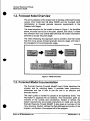
Granular Resources Forecast
Model User’s Guide
For Indian and NorthernAffairs Canada
and the Inuvialuit Land Administration
James C. McDougall, P.Eng.
C. William Tetz
NORTH
OF 00 ENGINEERING
LTD.
1400,800 5’” AVESW
CALGARY,
ALBERTA,T2P 3T6
February, 2002
Granular Resources Forecast
Model User's Guide
For Indian and Northern Affairs Canada
and the lnuvialuit Land Administration
James C. McDougall, P.Eng.
C. William Tetz
NORTH OF 60 ENGINEERING
LTD.
February, 2002
Granular Resources Forecast
Model User's Guide
Table of Contents
Table of Contents ..............................................................................................................
I. Introduction
1
I
1.I. Background........................................................................
1
1.2.
2
1.3.
1.4.
.'....................................
Forecast Model Overview .......................................................................................
Forecast Model Documentation..............................................................................
Conventions............................................................................................................
2
3
1.5. Technical Support ................................................................................................... 3
.
5
2 Getting Started
2.1. System Requirements ............................................................................................
5
2.2. Installing the ForecastModel..................................................................................
5
2.3. File Structure of Model............................................................................................
6
2.4. Starting the Program............................................................................................... 6
2.5. Program Structure ..................................................................................................
.
3 Granular Usage Database
7
8
3.1. Introduction............................................................................................................. 8
Database Fields......................................................................................................
9
3.3. Data Management ................................................................................................
12
Importing LlMS Data .............................................................................................
14
3.2.
3.4,
.
4 Analyzing Granular Usage
4.1,
14
Introduction...........................................................................................................
4.2. Demand Analysis..................................................................................................
14
14
Index
14
Appendix A .Program License
14
.
Appendix B Granula'r Material Types
.
NORTH
OF 60 ENGINEERING
LTD
14
Contents
i
Granular Resources Forecast
Model User's Guide
*
Granular Resources Forecast
Model User's Guide
.
'
,
I Introduction
I.I.
Background
Granular resources arean important construction material in the North.
Historically,granular material has been used in the construction of
roadways, airfield runways,embankments to supportbuildingsand
other physical structures, and in the construction of drilling pads and
temporary offshore exploration structures in the shallow waters of the
Beaufort Sea.
Granularresources(gravel)
in the MackenzieDeltaregion
of the
Northwest Territories are limited. Much work has been done during the
past quarter century to quantify the volumes and quality of the various
eskers(long,narrowridge
of coarse gravel depositedby a stream
flowing in a decaying glacial ice sheet) located in the region.
Historically, management of granular resources was the responsibility
of the Department of Indian and Northern Affairs, Canada. As part of
the lnuvialuit Land settlement in 1984, however, much of the granular
resources in the MackenzieDelta region are nowowned by the
Inuvialuit. Thus, management of the resource is now divided between
the Department andthe lnuvialuit Land Administration.
One of the key variables in managing the resource is the ability to
forecast potential demandson
an ongoingbasis.
The Granular
Resources Forecast Model provides for an efficient tool for archiving
and analyzing these demands.
NORTHOF 60 ENGINEERING LTD.
Introduction
0
I
Granular Resources Forecast
Model User's Guide
a
1.2. Forecast Model Overview
The primary objective of the project wasto develop a Microsoft Access
versionof the model that will allow DIAND and the Inuvialuit Land
Administration to forecast granular resourcerequirements
in the
Western Arctic Region.
As identified
The broad framework for the model is shown in Figure I.
above, the model can focus on the past, present, and future. It draws
this informationfrom one central data base that will contain information
pertinent to granular resource usage.
The intent in following this approach was to provide a tool that would
help the various groups forecast granular resource usage and help in
the management of current granular usage.
-
Figure 1 Model Overview
I.3. Forecast Model Documentation
The Granular Resource Forecast ModeP User's Guide describes the
program
and
its underlying
basis.
It provides
basic
instructions,
procedures and tips on how to use the tool in an effectiveand
accurate manner.
The user's guide is intended for people of all experience levels. The
information is organized into six sections. This introduction gives an
overview of the contents and conventions.Section 2 defines the
system requirements and provides instructions to install and use the
Granular Resource Forecast ModeP. It also gives an overview of the
menu structure. Section 3 defines the Data Management portionof the
program, and Section 4 the analysis half of the program.
NORTH
OF 60 ENGINEERING
LTD.
Introduction
2
Granular Resources Forecast
Model User's Guide
,
It is important to understand the terms andnotation conventions in this
user's guide before usingthe Granular Resource Forecast ModeP.
.
I.4. Conventions
General
The word "choose" is used to select a menu button.
Bold type in the text and procedures indicates words or characters
that are typed or buttons
that are selected.
Bulleted (e) lists,
such
as this one,
provide
information,
not
procedural steps.
A numbered list (1, 2, 3 ...) indicates a procedure with two or more
sequential steps.
Mouse
The documentationassumes that you have configured the left
mouse button as the primary mouse button.
"Point"means to position the mouse pointer until the tip of the
pointerrests on what you want to point to on the screen.For
example, "Point to the button Add or Update Data."
"Click" means to press and immediately release the mouse button
"Click on the button
withoutmoving the mouse.Forexample,
named Add or Update Data."
"Double-click"means to click the mouse button twiceinrapid
succession. For example, "Double-click on the Microsoft Excel icon
to start MicrosoftExcel."
Keyboard
Keynames
match the namesshown on mostkeyboards and
appear in small capital letters. For example, the Shift key appears
as SHIFT.
I.5. Technical Support
NORTHOF 60 ENGINEERING
LTD. offers a variety of support options to
help get the most fromthe Granular Resource Forecast Modeta. These
services include:
NORTHOF 60 ENGINEERINGLTD.
Introduction
0
3
Granular Resources Forecast
Model User's Guide
Custommodifications to the model
Customized
training
0
Technical
support
If you encounter a problem or have a question about the application,
first look in the printed documentation. If you cannot find the answer,
phone or fax NORTHOF 60 ENGINEERING
LTD. from 8 a.m. to 5 p.m.
(Mountain Time) Mondaythrough Friday.
NORTHOF 60 ENGINEERING
LTD. support services are subject to prices,
terms, and conditions in place at the time the service is required.
When you call, you should be at yourcomputer with the Granular
Resource Forecast ModeP running. Be prepared to give the following
information:
rn
The version of Microsoft Access you are using.
The type of hardware and operating environment you are using.
The exactwordingofanymessages
screen.
0
that appearedonyour
A description of what happened and what you were doing when
the problem occurred.
NORTHOF 60 ENGINEERING
LTD. can be reached by phone,fax or email:
Phone:
Fax:
Email:
-
(403) 263 2121
(403) 263 - 2122
[email protected]
Introduction
NORTHOF 60 ENGINEERING
LTD.
... .
...
"
4
Granular Resources Forecast
Model User's Guide
2. Getting Started
2A System Requirements
The Granular Resource Forecast Model@ has been developed under
Microsoft Access running on the Windows operating system. To use
the model you need the following minimum hardware:
Windows
A
98/ME/2000/XP
machine
with
Microsoft
Access
2000/2002 and Microsoft Excel 2000/2002installed.
Memory
(RAM)
requirements
for
Microsoft
Access
should
be
sufficient to operate the model.
0
0
Disk
space
depends
on the size of the database;
however
database size is typically 1 or 2 megabytes.
A Microsoft Windows-compatible printer is optional.
-
2.2. Installing the Forecast Model
The
following
*instructions
describe how to install the Granular
Resource Forecast ModeP on your computer. Although the model is
notcopyprotected,
Indian and Northern AffairsCanada, and the
lnuvialuit Land Administration may make copies onlyfor business use.
For complete details, please read the license agreement in Appendix
'A.
To install the Granular ResourceForecast ModeP:
1. The model and the database are contained in a singleMicrosoft
Access database file. The file can be copied to any folder on the
system using Windows Explorer.
NORTHOF 60 ENGINEERING LTD,
Getting Started
a
5
Granular Resources Forecast
Model User's Guide
2. To use the help feature of the model, the help files must be copied
to a folder called GRANMANUAL. This folder must be located in
the same folder as the model.
2.3. File Structure of Model
The Granular Resource Forecast ModeP has been developed as an
application within Microsoft Access so it requires Access to operate.
The installation procedure outlined in the previous section copied one
fileandonefolder
onto yourharddrive.Theirnames
and function
within the application are summarized in Table 1.
FileIFolder Name
GRANULAR.MDB
Description
Application and Database File
GRANMANUAL
Folder containingall the help files
-
Table 1 Granular Resource Forecast Model@Files
2.4. Starting the Program
To run the Granular Resource Forecast Model@ application:
1. Close any unnecessary applications that may be operating on your
computer to maximize memory and system resources. This is done
by selecting Exit fr0.m the File menu ofthe applications.
2. Open the GRANUlAR.MDB file by double clicking on the file icon
in WindowsExplorer,
or byusing the File-Open command in
Microsoft Access.
3. The Main Menu will appear:
NORTH
OF 60 ENGINEERING
LTD.
Getting Started
6
Granular Resources Forecast
Model User's Guide
-
Figure 2 Main Menu
2.5. Program Structure
The Granular Resource Forecast Model@is a database of historical,
currentand future granularrequirements. The applicationhasbeen
divided into two major components. The first half of the application is
devotedtoaddingandmaintaininginformation
within the database.
The details of the database will be discussed in the next section of the
User's Guide.
The second half of the application is devoted to analyzing the
information within the database, both from historical andfuture
perspectives. You can, for example, compare actual granular usage to
historical forecasts, or usage by area, source or quality. The analysis
section also allows, with limitations,users to define their own criteria to
study the data. The specifics on data analysis and the various reports
that are available are presentedin Section 4 of the User's Guide.
NORTH
OF 60 ENGINEERING
LTD.
Getting Started
0
7
Granular Resources Forecast
Model User's Guide
3. Granular Usage Database
3.1 Introduction
Thissection of the User's Guide focuseson the GranularUsage
Database, its makeup and procedures to maintain it.
As a user, you access the database by clicking,onthe Quarry Permits
button on the Main Menu (Figure2). The program will then present the
form shown below.
-
Figure 3 Quarry Permlts Form
NORTH
OF 60 ENGINEERING
LTD.
Granular Usage Database
8
Granular Resources Forecast
Model User's Guide
Information is entered to describe the Permit in terms of when the
granular material will be used, an estimate of the quantity and type of
materialneededfor the project, the location of the sourceand the
project, and actual permit values requestedand used,
If a small square button appears next to an input, the button leads to
moredetailedinformationabout
that input,suchas
a wizard for
entering latitude and longitude coordinates or a dialog box to edit the
list of permit holders, etc.
Of particular use is
the Quick List button, which brings up a table
listing all the permits and estimates and allows the user to quickly find
permits already enteredin the system.
-
Figure 4 Quarry Permlt List
Double clicking on a row will open that permit in the quarry permits
form. Right clicking on a field name will bring up a context menu that
includes various sorting optionsto reformat the list.
3.2. Database Fields
For those unfamiliarwith database terminology adatabase, or Sable as
it is often referred to, is a container for data about a particular subject,
in this case, granular resource usage. There aretwo basic elements in
a database. Each category of information is called a field. Thus, a
telephone book'has three fields: name, address, phone number. Each
set of information is called a record. For example, this entry in a phone
book constitutes a record:
Doe, John
NORTHOF 60 ENGINEERING
Lro.
13 Elm Street
5554321
Granular Usage Database
0
9
Granular Resources Forecast
Model User's Guide
DESCRIPTION
DATA
Permit #
Permit Number
Company responsible for permits Permit Holder
Date the record was modified
Date Modified
Estimate,
Source
Active,
Code
Closed,
Inactive
Identification
Status
Source
Category
End user classification e.g, Private,Government,Military,
Municipal
Year of Usage
Year of extraction and placement
Project Description
Description of project
LAT
Location Latitude (decimal degrees)
LONG
Location Longitude (decimal degrees)
Sponsor
Company Sponsoring the Project
Company that is extracting
gravel
Low Estimate
Low estimateof requirements
Most Likely Estimate
Likely estimate of requirements
Contractor
High estimate of requirements High Estimate
-
Most LikelylRandomlPSO the valueused in reports Estimate Default Value
Estimate Classification
Estimated material classifications
Requested requirements Requested Requirements
Requested class of material Requested
Class
Actual amount extracted Actual Requirements
Actual Class
Actual classification
-
Table 2 Granular Resource Data Base
There are two basic arrangements for tracking data. The telephone
book is a tabular database. The information is arranged in a table of
columns and rows. Another way to look at the information within the
database is through forms, much like a card file orRolodex. The
~.
NORTH OF 60 ENGINEERING
LTD.
. .
Granular Usage Database
10
Granular Resources Forecast
Model User's Guide
Granular Resource Forecast Mod el@uses forms and tables to record
and view granularusage.
The granular usage database contains many fields of information for
each record. These fields are summarizedin Table 2 and discussed in
detail below.
Quarry Permit #:
Is the quarrypermitnumber.
Permit Holder:
Theperson or company that is requesting the
permits. This wouldgenerally be the person
responsiblefor the payment of royalties and
meeting the conditions ofthe permit.
Date,Modified:
This
represents the date the record was first
enteredorlastupdated.
It is enteredby the
user.
status:
This is the status of the specific project. The
user should enter one of the following
depending on the stage of development.
Estimate
Active
0
Inactive
0
Closed
Source:
The gravel source number/lD within the block.
Category:
A descriptive category for the sponsor. NORTH
OF 60 ENGINEERING
LTD. recommends that a
limited number of categoriesbe used. Possible
examples are:
Public
Private
Defence
Year of Use:
The year that the material was used.
Initially
this would be an estimate, but would change to
reflect actual year of use.
Project Description: A brief description of the project.
Project Location:
The location of the project.
Latitude
and
longitudes are recommended.
Sponsor:
The name of the individual
company
municipality that is sponsoring the project.
NORTH
OF 60 ENGINEERING
LTD.
Granular Usage Database
..
.
or
0
I1
Granular Resources Forecast
Model User's Guide
Contractor:
The person orcompanyactuallyundertaking
the quarryoperations.
In manycases,
this
would be the same as the permit holder.
Low Estimate:
A low side estimate of the amount of material
to be required, expressed in cubic meters.
Likely Estimate:
A likely estimate of the amount of material to
be required, expressed in cubic meters.
High Estimate:
A high side estimate of the amount of material
to be required, expressedin cubic meters.
Estimate Default:
Value to use in creating reports. The value is
calculated based on a triangular distribution
definedby
the low/likely/highestimatesas
described above.
Mean/MostLikely
-
Random random value each time
0
Estimated Class:
P50 - 50% probability
An estimate of the required class of material
(1-5). The specific classes are
defined
in
Appendix B of the User's Guide.
Requested Amount: The amount of material requested at the time
of quarry permit application.
Requested Class:
The class of material requested at the time of
quarry permit application.
Actual Amount:
The actual amount of material used. Generally
speaking this would be based on trip tickets or
an actual survey of the quarry siteat the end of
the project,
Actual Class:
The actual class of the material used.
3.3. Data Management
Record Navigation Buttons
The record navigation buttons are used to scroll through the records
onaform.
Figure 5 shows the typical recordnavigationbuttons in
Microsoft Access. Navigating to the next or previous record is done by
clicking on the arrow buttons. Navigating to the first or last record is
NORTHOF 60 ENGINEERINGLTD.
Granular Usage Database
12
Granular Resources Forecast
Model User"sGuide
done by clicking on the buttons with arrows and bars. Creating a new
record can be done by clicking on the button with an arrow and an
asterisk "*". The record number can also be entered in the text box to
navigate directlyto a specific record.
,,,,,
""""""""
,
,
.**..
, -."-
-
Figure 5 Record Navigation Buttons
Adding, Updating or Deleting Records
To Add a Record
1. Display the Quarry Permits Form.
2. Choose the New Button.
3. Enter data in the new record's fields. Press TAB to move between
fields.
4. Repeat steps 1 and 2 to add as many records as you want.
To Delete a Record
Note: Deleted records cannot be restored.
To delete a record:
I.Display the Quarry Permits Form.
2. Display the record you wantto delete.
3. Choose the Quick List button. Make sure the record you want to
delete is selected.
4. Push the DELETE key on the keyboard.
To Find a Record
1. Display the Quarry Permits Form.
2. Select the field that you want to search.
3. Choose the Find command from the edit menu or the toolbar.
4. Enter the criteria in the dialog box and choose Find Next.
NORTHOF 60 ENGINEERING
LTD.
GranularDatabase
Usage
13
Granular Resources Forecast
Model User's Guide
It may be easier to search the permitsbysorting
display the permitsin a specific order.
the quick list to
To Edit Records
I,Display the Quarry Permits Form.
2. Locate the record to edit.
3. Edit each field you want to change. Press TAB to move between
fields. TO cancel changes of a record, press the ESC key on the
keyboard.
To Return to the Main Menu
1. Choose the Close button when you are finished workingin the data
form.
2. Alternatively,choose the X button in the top rightcornerof the
dialog box.
Special Controls
Some fields on the Quarry Permits Form have special controls that
help select and manage the data entering in the field. These fields
have a small button beside them that will open a dialog box to edit lists
such as sources,companynames
and addresses,blockareas,or
latitude and longitude DMS entry.
View Database
To viewthegranular
usage database in tabularform, choose the
Unhide command from the Window menu.Select the database
window and choose OK. Editing the tables directly requires advanced
skill in Microsoft Accessand Relational Database Design.
Backup Database
To backup the database, copy the GRANULAR.MDB file to a floppy
disk, CD or alternate folder.
Compacting the Database
As records are modified and deleted the database increases in size.
Periodically compactingthe database is required to keep the database
file small. Choose the Compact & Repair Database command from
the Tools menu in Microsoft Access.
NORTH
OF 60 ENGINEERING
LTD.
Granular
Usage
Database
0
14
Granular Resources Forecast
Model User's Guide
3.4, Importing LIMS Data
LlMS is an alternate
database
that contains
granular
resource
information that can be imported into the model. This is an advanced
feature that requires knowledge of Microsoft Access table linking.
A
procedureforimporting
LlMS using the LIMSSAMPLEDATA.XLS
worksheet follows:
1. Choose Import LIMS Data from the main menu.
2. Choose Link External Table from the dialog box that appears.
3. Afileopendialogboxappears.Select
the file that contains the
LlMS data, and click on the Link button. You may need to change
the file type to Microsoft Excel if the data is in a spreadsheet. For
this example look for the LIMSSAMPLEDATA.XLS workbook in the
GRANMANUAL folder.
4. The MicrosoftAccessLinkSpreadsheetWizardappears.Select
the worksheet or named range that contains the data and choose
Next.
5. If asked to use the first row as column headings, select the option
and choose Next.
6. tf asked to enter a table name, use the default name given and
choose Finish. The LlMS data should be linked to the application.
7. When back to the LlMS Import dialog box, choose Next to add the
LlMS data to the database, or Cancel to return to the main menu.
It is extremely important that the LlMS data be formatted in a table
likethedata in LIMSSAMPLEDATA.XLS.Particularattentionshould
be made tothe field names in the sample file.
NORTH
OF 60 ENGINEERING
LTD.
Granular Usage Database
15
~
Granular Resources Forecast
Model User's Guide
4. Analyzing Granular Usage
4.1 . Introduction
-..
~~
Thissection
of theUser's
Guide describes the variousoptions
available to the user to analyze data within the database. It also covers
the available reporting options.
4.2. Demand Analysis
Actual vs. Forecast
Selecting the Forecast Chart button on the menu produces a graph
showing the historical granular usage. The graph shown in Figure 6
plotsestimatedrequirements,requestedamountsandactual
usage.
Over time,this plot will tell whether initial estimates are high or low.
Granular Forcast Quantities
e
-
Figure 6 Granular Resource Usage Graph
NORTH OF 60 ENGINEERING
LTO,
Analyzing Granular Usage
16
Granular Resources Forecast
Model User's Guide
Usage by Area
Selecting the Quantities by Block button on the menu produces a
cross-tabulation of the database showing the granular usage by area.
Figure 7 is an example viewof resource usage by area.
For those unfamiliar with cross-tabulations, or pivot tables as they are
referred to in Excel, they are a subset of the database representing
various categories within the database.' In this case, the pivot table is
summarizing the usage by year into the variousareas.The
table
shows the yearsalong the side (row)and areas acrossthe top
(column). The need and usage of this terminology will become more
evident.
Permit QuantitySummary by Block
!
-
Figure 7 Granular Resource Usage by Area
Usage by Source and Quality
Selecting the Quantities by Material Class button on the menu
produces a cross-tabulation of the databaseshowing the historical
granular usage by source and class of material. In this pivot table, the
sources are listed by page (each page is one source) and the class of
material along the top (column).
NORTH
OF 60 ENGINEERING
LTD.
Analyzing Granular Usage
17
Granular Resources Forecast
Model User's Guide
User Defined Analysis
The pivot tables can be modified to filter the data. The modifications
are not permanent and will be reset the next time the application is
opened.Proficientknowledge
of Microsoft Excel pivot tables is
recommended when modifyingthe pivot table reports.
Report All Records
Selecting the All Records button on the menu produces a report with
tablelistingeachpermitandestimate
that is entered into the
database. The table shows each field that is available for each record
and is formatted to print on tabloid sized paper.
NORTH
OF 60 ENGINEERING
LTD.
Analyzing
Granular
Usage
18
Granular Resources Forecast
Model User's Guide
Form, 13,14
Getting Started, 5
Granular Resource' Data Base,10
Index
Granular resources, 1
Granular Usage Database,8
gravel, 1
High Estimate, 12
Historical Demand, 16
Installation, 5
Introduction, 1
Actual Amount, 12
Keyboard, 3
Actual Class, 12
Low Estimate, 12
Actual vs. Forecast, 16
Main Menu, 7
Add a Record, 13
Add or Update Data,8
Mean Estimate, 12
Adding, Updating or Deleting Projects,
13
model framework, 2
Model Overview, 2
Mouse, 3
Analyzing Granular Usage, 16
Permit Holder, 11
Background, 1
Program Structure, 7
Backup Database, 14
Project Description, 11
Contractor, 12
Project Location, 11
Conventions, 3
Project objective, 2
Data Management, 12, 15
File Structure, 6
Quarry Permit #, 11
Quick List, 9
Record Navigation, 12
Requested Amount, 12
Requested Class, 12
Source #, 11
Sponsor, 12
Sponsor Category, 1I
Starting the Program, 6
Find a Record, 13
Status, 11
Data Management Menu, 8
Database Fields, 9
Date of Record, 11
Delete a Record, 13
Documentation, 2
Edit Records, 14
Estimated Class, 12
NORTH
OF 60 ENGINEERING
LTD.
Index
19
Granular Resources Forecast
Model User's Guide
System Requirements, 5
Table of Contents, i
Technical support, 4
Technical Support, 3
Training, 4
Usage by Area, 17
Usage by Source and Quality, 17
User Defined Analysis, 18
View Database, 14
Year of Use, II
Index
NORTH
OF 60 ENGINEERING
LTD,
..
.
.. . . .".".
0
20
Granular Resources Forecast
Model User's Guide
Appendix A = Program License
The Granular Resource ForecastModel Q is copyrighted by NORTH
OF
60 ENGINEERINGLTD.andlicensed to the Department of Indianand
Northern Affairs and the lnuvialuit Land Administration pursuant to the
general conditions set out in document 1632-99-0450. Users of this
modelmaynotmakeany
use of Software that is not expressly
provided forin the general conditions.'
NORTHOF 60 ENGINEERING LTD.
shall, for a period of 90 days from the
date of delivery, replace any disketteon which the Software is supplied
which is defective in material orworkmanshipundernormaluse.
NORTHOF 60 E NEINEERING LTD. does not make any representations
regarding
the
use, or the results of use, of the Software
or
Documentation in terms of correctness or otherwise. The entire risk as
to the results and performance of the model is assumed by the user.
NORTH OF 60 ENGINEERING
LTD. specifically
disclaims
all other
warranties,expressedorimplied,including
but notlimited to any
implied term, cqndition, representation or warranty of merchantability
orfitnessfor
a particularpurpose, that the model will meetyour
requirements, that the operation of the model will be uninterrupted or
error free, or that our maintenance will remedy any error, deficiency or
other bug encountered.
Information in this Model is subject to change without notice and does
not represent a commitment on the part of NORTHOF 60 ENGINEERING,
LTD.
NORTHOF 60 ENGINEERING
LTD.
Appendix A
0
21
Granular Resources Forecast
Model User's Guide
Appendix B = Granular Material Types
CLASS
MATERIAL DESCRIPTION
I
Excellentquality material consisting of clean,wellgraded, structurally-sound sand and gravel suitable for
use as high-quality (e.g. runway or roof) surfacing
materials, or as asphalt or concrete aggregate, with a
minimum of processing.
2
Good quality material generallyconsisting
of wellgraded sands and gravels with limited quantitiesof silt.
This material will provide good quality
base
and
surface coarse aggregates or structure-supporting fill.
Production of concrete aggregatesmay be possible
withextensiveprocessing,exceptwheredeleterious
materials are present.
3
Fairquality material consistinggenerally of poorlygraded sands and gravels with or without substantial
siltcontent.This
material willprovide
fair quality
general fill forroads,flexiblefoundationpads,or
staging areas.
4
Poor quality material consisting of silty, poorly-graded,
fine grained sand, with minor gravel. May also contain
weak particles anddeleteriousmaterials
and- are
consideredsuitableonlyformarginal,
general (non
structural) fills.
5
Bedrock of fair to good quality,felsenmeerortalus.
Potentially excellent sources of construction material,
ranging from general fill to concreteaggregate or
building stone if quarried and processed. Also includes
erosion control materialssuchasrip-rap
or armour
stone.
NORTH
OF 60 ENGINEERING LTD.
Appendix D
22