1
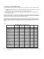
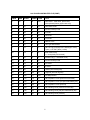
1991 PLACE NAME MASTER FILE
USER GUIDE
Produced by the Geography Division
Statistics Canada
April 1993
ABOUT THIS GUIDE
This guide is intended for users of the 1991 Place Name Master File (PNMF). It includes a description of the
general methodology used to create the file, a record layout and supplementary information.
The first section provides a general overview of the 1991 Place Name Master File in terms of its purpose,
how it compares with the previous file and the general methodology used. The second part of the guide
provides a record layout that outlines the 23 fields featured in the file, including a section relating to the
content of each field. Section 3 describes data quality and limitations of the file contents. A glossary of the
terms used in this document is also included.
This guide is based on the best information available at the time of its release. It in no way constitutes a
warranty in the event that users should observe characteristics that deviate from those stated in this
document.
TABLE OF CONTENTS
1
1991 PNMF OVERVIEW ...............................................................................................................
1.1
Introduction .......................................................................................................................
1.2
Purpose of the 1991 PNMF ..............................................................................................
1.3
History of the 1991 PNMF.................................................................................................
1.4
Overview of the 1991 PNMF Content ...............................................................................
1
1
1
1
2
2
TECHNICAL SPECIFICATIONS....................................................................................................
2.1
Structure of the 1991 PNMF .............................................................................................
2.2
Record Layout...................................................................................................................
2.3
Field Descriptions for 1991 PNMF....................................................................................
3
3
3
6
3
DATA QUALITY STATEMENT ....................................................................................................
3.1
Introduction .....................................................................................................................
3.2
Lineage ...........................................................................................................................
3.2.1 Place Names......................................................................................................
3.2.2 Place Name Codes ............................................................................................
3.2.3 Standard Geographic Area Codes.....................................................................
3.2.4 Attribute Flags ....................................................................................................
3.2.5 Geographic References .....................................................................................
3.2.6 Enumeration Area Codes...................................................................................
3.2.7 Unincorporated Place (UP) Population and Dwelling Counts ...........................
3.2.8 Census Subdivision (CSD) and Enumeration Area (EA) Population and
Dwelling Counts .................................................................................................
3.3
Positional Accuracy.........................................................................................................
3.4
Logical Consistency ........................................................................................................
3.4.1 Population and Dwelling Counts........................................................................
3.5
Completeness .................................................................................................................
3.6
Attribute Accuracy...........................................................................................................
3.6.1 Estimated Population and Dwelling Counts for UPs..........................................
3.6.2 Quality Control ...................................................................................................
12
12
12
12
13
13
14
14
15
15
16
16
16
16
17
17
17
17
4
GLOSSARY OF TERMS.............................................................................................................. 19
5
SPECIAL NOTES......................................................................................................................... 28
5.1
Incompletely Enumerated Indian Reserves and Indian Settlements.............................. 28
5.2
Non-Permanent Residents.............................................................................................. 28
6
FOR FURTHER INFORMATION ................................................................................................. 29
6.1
For Further Information ................................................................................................... 29
6.2
Additional References and Services............................................................................................ 30
APPENDIX "A" DECIMAL DEGREES AND DEGREES, MINUTES, SECONDS.................................... 31
─────────────────────────────────────────────────────────────────
1
1991 PNMF OVERVIEW
─────────────────────────────────────────────────────────────────
1.1
Introduction
The 1991 Place Name Master File (PNMF) is a digital product which provides population and dwelling
counts for census subdivisions (CSDs) and unincorporated places (UPs) linked to enumeration areas
(EAs). In addition, the current version of the PNMF also provides over 21,000 other place names (PNs)
linked to standard geographic areas through the Standard Geographical Classification (SGC). (For
definitions see Glossary of Terms.)
1.2
Purpose of the 1991 PNMF
The purpose of the 1991 PNMF is to provide a machine-readable version of the published 1991 Census
Place Name Lists, which are presented in three publications:
Atlantic Region
Quebec and Ontario
Western Provinces
and the Territories
Catalogue No. 93-307
Catalogue No. 93-308
Catalogue No. 93-309.
A national listing of UPs with 1991 Census population counts is published as Unincorporated Places,
Catalogue No. 93-306. 1991 Census population and dwelling counts are published for census
subdivisions in Catalogue No. 93-304.
Place names (excluding the 1991 UPs) which were published in the 1991 Standard Geographical
Classification Manual, Catalogue No. 12-571, as Table 7, `Place Name Index', provided another source
of names for the 1991 PNMF.
As a result, the 1991 PNMF is a compilation of names from many sources and, therefore, provides the
most comprehensive set of names available from Statistics Canada.
1.3
History of the 1991 PNMF
A machine-readable equivalent for the published place name reference lists has been available since
1971. The principal difference in the 1991 PNMF from previous versions is that the 1991 file includes
other place names which have been maintained to the most current SGC, in addition to urban places,
historical names, dissolved CSDs, and alternative spellings.
Another added feature to the 1991 PNMF is the inclusion of dwelling counts for places with a link to an
enumeration area(s).
In addition to these content changes, the record layout of the 1991 PNMF differs significantly from the
previous versions.
1
1.4 Overview of the 1991 PNMF Content
The 1991 PNMF can be described as being composed of four types of places. These are classified as follows:
1. unincorporated places (identified by the census representative (CR) as having five dwellings or more) linked
to EAs;
2. other places (identified by the CR as having less than five dwellings) linked to EAs;
3. place names linked to the SGC only (eg. alternate names, different spellings, and historical places); and,
4. census subdivision names.
These four types of places are combined on the 1991 PNMF, and a breakdown of how they are distributed by
province is shown in Table 1. The 1991 SGC code linkage is provided for all records on the file. Population and
dwelling counts are provided for CSDs and place names linked to EAs only.
A place name code is assigned to each unique place with the exception of CSD names. Where this code is
repeated it indicates places which are separated into multiple records (linked to more than one EA and/or CSD)
on the file. Multiple records result in an additional 2,653 records on the file, bringing the total record count to
42,938.
Table 1
1991 PNMF Place Name Types by Province
Province
UPs linked
PNs linked to
PNs linked to
to EAs
EAs (Non UP)
SGC only
CSDs
Total
Newfoundland
468
54
1,332
404
2,258
Prince Edward Island
486
12
336
126
960
Nova Scotia
2,120
139
1,186
118
3,563
New Brunswick
1,520
77
1,365
287
3,249
Quebec
777
110
5,264
1,637
7,788
Ontario
2,731
784
5,156
951
9,622
Manitoba
483
103
901
293
1,780
Saskatchewan
336
177
1,611
953
3,077
1,110
196
1,405
438
3,149
British Columbia
915
202
2,270
691
4,078
Yukon Territory
39
37
227
36
339
4
3
343
72
422
10,989
1,894
21,396
6,006
40,285
Alberta
Northwest Territories
Canada
Notes:
Unincorporated places are the names found in the Place Name Reference List Catalogue Nos. 93-307, 93-308, and 93-309, and Unincorporated
Places, Catalogue No. 93-306.
2
Place names linked to multiple EAs explain the difference of 2,653 between the total number of place names (40,285) and the total record count (42,938).
3
─────────────────────────────────────────────────────────────────
2
TECHNICAL SPECIFICATIONS
2.1
Structure of the 1991 PNMF
─────────────────────────────────────────────────────────────────
Most of the place names are represented by a single record; however, multiple records occur when a
place name straddles two or more EAs. As a result, the same place name will be repeated two or more
times with different geographic information.
Refer to the sample printout following the record layout in this section.
Place names on the 1991 PNMF are sorted alphabetically by province/territory.
2.2
Record Layout
The content of the 1991 PNMF is described in the following record layout.
4
1991 PLACE NAME MASTER FILE (PNMF)
FIELD
SIZE
START
FINISH
TYPE
TITLE
1
50
1
50
AN
Place Name - CSD name, place name,
unincorporated places (upper case only)
2
6
51
56
N
Place Name Code
3
2
57
58
N
Province/Territory Code
4
2
59
60
N
CD Code
5
3
61
63
N
CSD Code
6
3
64
66
N
CCS Code
7
3
67
69
N
CMA/CA Code
8
3
70
72
A
CSD Type Abbreviation
9
1
73
73
A
1991 UP Flag (a locality with 5 dwellings or more)
(T(true) = UP and F(false) = other)
10
1
74
74
A
Indian reserve flag
(1 = incompletely enumerated)
11
1
75
75
A
Estimate Flag (* = estimated count)
12
2
76
77
N
Province/Territory Code
13
3
78
80
N
FED Code
14
3
81
83
N
EA Code
15
11.6
84
94
N
Latitude (decimal degrees)
16
11.6
95
105
N
Longitude (decimal degrees)
17
6
106
111
AN
NTS Map Number
18
8
112
119
N
1991 Population Count (total PN or total CSD)
19
5
120
124
N
1991 Population Count (PN part subdivided by EA)
20
5
125
129
N
1991 Population Count (total EA)
21
8
130
137
N
1991 Dwelling Count (total PN or total CSD)
22
5
138
142
N
1991 Dwelling Count (PN part subdivided by EA)
23
5
143
147
N
1991 Dwelling Count (total EA)
5
2.3
Field Descriptions for 1991 PNMF
Field 1:
Place Name (PN), Unincorporated Place (UP) or Census Subdivision (CSD)
This field contains the names of unincorporated places, census subdivisions, or other places.
Field 2:
Place Name Code
This field provides a unique number for each unique place name. Where this field is repeated, it identifies
place names with multiple parts. This field is blank for CSD name records.
Field 3:
Province/Territory Code
The province/territory is designated by a 2-digit code that is based on the Standard Geographical
Classification. The code is assigned from east to west. The first digit represents the region of Canada to
which the province belongs; the second digit denotes one of the ten provinces and two territories.
Region
Province
Atlantic Newfoundland
10
Prince Edward Island
Nova Scotia
New Brunswick 13
Quebec Quebec
24
Ontario Ontario
35
Prairies Manitoba
46
Saskatchewan
Alberta
B.C.
British Columbia
Territories
Yukon Territory 60
Northwest Territories
Code
11
12
47
48
59
61
The 2-digit province code is a unique identifier that must be used when identifying a specific area within
the hierarchy (i.e., federal electoral district (FED), enumeration area (EA), census division (CD), census
consolidated subdivision (CCS), and census subdivision (CSD)).
Field 4:
Census Division (CD) Code
The CD is designated by a 2-digit code based on the Standard Geographical Classification (SGC). In
order to uniquely identify each CD in Canada, the code must be preceded by the 2-digit province code.
6
For example:
PR/CD Code
CD Name
12 03
24 03
35 15
59 15
Digby County
La Côte-de-Gaspé
Peterborough County
Greater Vancouver Regional District
Field 5:
Census Subdivision (CSD) Code
The CSD is designated by a 3-digit code based on the Standard Geographical Classification (SGC). In
order to uniquely identify each CSD in Canada, the code must be preceded by the 2-digit province code
and the 2-digit CD code. For example:
PR/CD/CSD Code
CSD Name
12 09 021
35 09 021
Halifax
Perth
Field 6:
Census Consolidated Subdivision (CCS) Code
The code assigned to each CCS is based on the Standard Geographical Classification (SGC) code of
one of its component CSDs, usually the one with the largest land area.
Field 7:
Census Metropolitan Area (CMA)/Census Agglomeration (CA) Code
The CMA/CA is designated by a 3-digit code that uniquely identifies each urban centre in Canada. The
first digit of the CMA/CA code uses the second digit of the province code (except for the Territories where
the CMA/CA code starts with number 9). If a CMA or CA crosses a provincial boundary, the first digit of
the code reflects the province that contains the CMA portion with the higher population (e.g., CMA code
505 for Ottawa - Hull). The second and third digits are assigned in numeric order from 01 to 99 by
province.
For example:
CMA/CA Code CMA/CA Name Province
001
205
421
505
935
990
995
St. John's
Halifax
Québec
Ottawa - Hull
Victoria
Whitehorse
Yellowknife
10
12
24
35
59
60
61
7
(A code only appears for a valid CMA/CA, otherwise the field is left blank.)
Field 8:
Census Subdivision (CSD) Type
The CSD type indicates the municipal status of a census subdivision. The following list indicates all CSD
types and their abbreviations:
Abbreviation
CSD types
BOR
C
CM
COM
CT
CU
DM
HAM
ID
IGD
LGD
LOT
MD
NH
NV
P
PAR
R
RM
RV
SA
SCM
SD
S-E
SET
SRD
SUN
SV
T
TP
TR
UNO
V
VC
VK
VL
VN
Borough
City - Cité
County (municipality)
Community
Canton (municipalité de)
Cantons unis (municipalité de)
District municipality
Hamlet
Improvement district
Indian government district
Local government district
Township and royalty
Municipal district
Northern hamlet
Northern village
Paroisse (municipalité de)
Parish
Indian reserve - Réserve indienne
Rural municipality
Resort village
Special area
Subdivision of county municipality
Sans désignation (municipalité)
Indian settlement - Établissement indien
Settlement
Subdivision of regional district
Subdivision of unorganized
Summer village
Town
Township
Terres réservées
Unorganized - Non organisé
Ville
Village cri
Village naskapi
Village
Village nordique
8
This field may be used as a flag to differentiate CSD names from other place names or to distinguish
between CSDs with the same name.
Field 9:
1991 Unincorporated Place (UP) Flag
This field flags whether or not the place name is a locality with five dwellings or more (an unincorporated
place). The symbol "T" (true) is used to indicate an unincorporated place (UP). The symbol "F" (false)
appears for all other records, except for CSDs where it is left blank.
Field 10:
Incompletely Enumerated Indian Reserve Flag
This field designates those CSDs which contain incompletely enumerated Indian reserves and Indian
settlements. On some Indian reserves and Indian settlements in the 1991 Census, enumeration was
either not permitted or was interrupted before it could be completed. The CSDs represented by this field
are identified by a number "1"; however, the field is left blank in cases where the CSD it represents is not
part of the incompletely enumerated Indian reserves and Indian settlements.
Field 11:
Estimate Flag
This field flags UPs for which 1991 population and dwelling data have been estimated. An asterisk (*) is
used to symbolize places where estimates have been made. This field is otherwise blank.
Field 12:
Province/Territory Code
Same as field 3.
Field 13:
Federal Electoral District (FED) (1987 Representation Order) Code
The FED is designated by a 3-digit code. In order to uniquely identify each FED in Canada, the code
must be preceded by the 2-digit province code. For example:
PR/FED Code
12 005
47 005
59 001
61 001
FED Name
Central Nova
Regina-Lumsden
Burnaby-Kingsway
Nunatsiaq
Field 14:
Enumeration Area (EA) Code
9
The EA is designated by a 3-digit code. In order to uniquely identify each EA in Canada, the code must
be preceded by the 2-digit province code and the 3-digit FED code. For example:
PR/FED/EA Code
Description
12 009 251
Province 12: Nova Scotia
FED 009: Halifax West
EA: 251
35 009 251
Province 35: Ontario
FED 009: Cambridge
EA: 251
46 009 251
Province 46: Manitoba
FED 009: Winnipeg North
EA: 251
Field 15:
Latitude (decimal degrees)
This field identifies the latitude (in decimal degrees north of the equator) of the EA representative point or
the visual centre of the CSD.
Field 16:
Longitude (decimal degrees)
This field represents the longitude (in decimal degrees west of the prime meridian) of the EA
representative point or the visual centre of the CSD.
Field 17:
National Topographic System (NTS) Map Number
This field identifies the 1:50,000 NTS map number which has been derived using latitude/longitude data
(see Methodology section 1.5.2 and Glossary of Terms).
One NTS reference is provided for each place name. Often places (especially rural CSDs) cover more
than one NTS map sheet. As a result, the NTS reference is only a guide to the location of a given place.
Field 18:
1991 Population Count (total PN or total CSD)
This field gives the total population for a place name. Population counts for CSD records are found in this
field also (see Glossary of Terms).
10
Field 19:
1991 Population Count (PN part subdivided by EA)
A place name can have multiple EAs associated with it. This field provides the population for the place
name part(s) tied to a specific EA. (see sample of the file's content in Technical Specifications following
the record layout.) Where a place name has a single EA linkage, the total place name population count is
repeated in this field.
Field 20:
1991 Population Count (total EA)
Refers to the total population of the EA.
Field 21:
1991 Dwelling Count (Total PN or total CSD)
This field gives the total dwelling count for a place name. Dwelling counts for CSD records are found in
this field also (see Glossary of Terms). Note that the dwelling universe for place names differs from that
for CSDs and EAs (see Methodology section).
Field 22:
1991 Dwelling Count (PN part subdivided by EA)
A place name can have multiple EAs associated with it. This field provides the dwelling count for the
place name part(s) tied to a specific EA. (see sample of the file's content in Technical Specifications,
page 5) Where a place name has a single EA linkage, the total place name dwelling count is repeated in
this field.
Field 23:
1991 Dwelling Count (total EA)
Refers to the total dwelling count of the EA.
11
─────────────────────────────────────────────────────────────────
3
DATA QUALITY STATEMENT
3.1
Introduction
─────────────────────────────────────────────────────────────────
The purpose of a data quality statement is to provide detailed information for users to evaluate the
suitability of the data for a particular use.
This document reports on the data quality of the 1991 Place Name Master File (PNMF). Five
fundamental components of a data quality statement are: lineage, positional accuracy, logical
consistency, completeness, and attribute accuracy.
This data quality statement in no way constitutes a warranty of the data in the event that characteristics
are observed that deviate from those stated here.
3.2
Lineage
Lineage includes descriptions of the source material from which the data were derived and the methods
of derivation, including the dates of the source material and all transformations involved in producing the
final digital files.
The contents of the 1991 PNMF may be described as being composed of the following attributes:
- place names
- place name codes
- standard geographic area codes
- attribute flags, i.e.,
CSD type,
UP flag,
incompletely enumerated Indian reserve flag,
estimate flag,
- enumeration area codes
- geographic references, i.e., latitude/longitude,
NTS map number,
- population counts
- dwelling counts.
Lineage is described by the various types of attribute information found on the file.
3.2.1
Place Names
Names of census subdivisions and other localities, (either those linked to EAs or linked to the SGC code
only) are generically referred to as "place names" (PN).
Names of census subdivisions are generally provided to Statistics Canada by the provincial/territorial
municipal authorities from legislated documents. Most official
names are accepted as legislated; however, some abbreviating
is done for the sake of consistency and clarity, e.g., "City of
12
Ottawa" appears as "Ottawa". Furthermore, extremely long
names (i.e. exceeding 50 characters) have been abbreviated,
with approval from provincial contacts. Where CSDs are not
legislated and have been created for classification purposes, the
names have been assigned in cooperation with provincial and
other federal officials.
Names of places (other than CSDs) appearing on the 1991 PNMF have been accumulated from a variety
of sources including:
-
-
names reported by the census representatives during the 1991 Census and previous censuses
(1981 and 1986),
names approved by the provincial and territorial names authorities on the Canadian Permanent
Committee on Geographical Names (CPCGN) and included in the Canadian Geographic Names
Database. The CPCGN standardizes and co-ordinates policies and procedures for geographical
naming in Canada. The Surveys, Mapping and Remote Sensing Sector of the Department of
Energy, Mines and Resources provides the committee with a secretariat,
historical names, e.g. municipalities which have been dissolved or renamed,
alternative spellings, due to different sources,
names of urban areas.
3.2.2
Place Name Codes
-
A unique six digit numeric code has been assigned to each place name (except CSD names) on the 1991
PNMF.
This code may be used to identify place names which are repeated however representing different places
and therefore having different place name codes. The place name code may also be used to identify
unique places, which are listed more than once due to linkage with multiple EAs. These records will
share the same place name code.
3.2.3
Standard Geographic Area Codes
Geographic codes are numeric codes that are assigned to all standard geographic areas and are used as
unique identifiers. The initial source of the geographic codes was the 1991 Geographic Attribute Data
Base. The original source and the source for updates are described below.
The system of geographic codes for provinces and territories, census divisions, and census subdivisions
is the Standard Geographical Classification (SGC). This classification system is a hierarchical coding
system that provides a unique identifier for each level of the hierarchy. This coding is developed by
Statistics Canada and approved by provincial authorities.
For a census consolidated subdivision, the code is derived from the component census subdivisions.
The census consolidated subdivision's code usually coincides with its largest census subdivision
component in terms of land area.
The source of the geographic codes of federal electoral districts is the 1987 Representation Order - Chief
Electoral Office, Elections Canada.
All other geographic codes are developed by Statistics Canada.
13
3.2.4
Attribute Flags
CSD Type
CSD type abbreviations are taken from the 1991 Geographic Attribute Data Base and reflect the status of
municipalities as of January 1, 1991.
UP Flag
This field is generated based on the final dwelling counts of unincorporated places compiled by Statistics
Canada. A value of five or more dwellings was flagged as an unincorporated place.
Incompletely Enumerated Indian Reserve Flag
This field identifies those CSDs located in incompletely enumerated Indian reserves and Indian
settlements. On some indian reserves and indian settlements in the 1991 Census, enumeration was
either not permitted or was interrupted before it could be completed.
Estimate Flag
Where places were observed during the compilation of UPs, and data were missing from the map or the
visitation record (VR), an estimation based on the best available information (maps and/or VR) was
made. The 1991 PNMF contains an estimate flag for data assigned to these places.
3.2.5
Geographic References
Latitude/Longitude
The latitude and longitude coordinates assigned to those place names with a link to enumeration areas
were derived from the EA representative points calculated for census purposes. A representative point is
a pair of coordinate values (x, y) that represents a geographic entity for the purpose of assigning
aggregate data to that entity. An enumeration area representative point is located either near a cluster(s)
of buildings and/or streets, or at the visual centre of the EA. (see Glossary of Terms)
For places which are linked to more than one EA, the representative point of the EA containing the place
name part with the largest population is used.
The latitude and longitude coordinates assigned for CSDs and those place names with an SGC linkage
only, used ARC\INFO® label points to assign the approximate position of the geographic centre based on
the 1991 digital CSD boundaries. Where CSDs have multiple parts (polygons) on the boundary file, the
CSD part (polygon) with the largest area was used to generate a latitude/longitude.
Although the 1991 Place Name List presents latitude and longitude in degrees and minutes, these
coordinates are given in decimal degrees on the 1991 PNMF. This is standard practice for the display of
such data in machine-readable form. A conversion calculation for decimal degrees to degrees, minutes,
and seconds is attached to this user guide as Appendix A.
NTS
The NTS map reference (1:50,000) was calculated using the latitude/longitude coordinates. One NTS
reference was provided for each place name. Often places (especially rural CSDs) cover more than one
14
NTS map sheet. As a result, the NTS reference is only a guide to the location of a given place.
3.2.6
Enumeration Area Codes
These codes are the final EAs taken from the 1991 Geographic Attribute Data Base.
3.2.7
Unincorporated Place (UP) Population and Dwelling Counts
An unincorporated place, as defined by the census, is a cluster of five or more occupied dwellings
situated in a rural area. Unincorporated places must also be known locally by a specific name but have
no local government or legal boundaries.
Because unincorporated places have no legal or official boundaries, it is not possible to define
enumeration areas that correspond to unincorporated places. They are identified primarily by census
representatives (CR) during the data collection phase. To ensure the greatest possible uniformity in
identifying unincorporated places, census representatives are instructed to identify all clusters of
dwellings that fit the definition of an unincorporated place. To assist them in their work, the census
representatives are provided with a list of the unincorporated places that were in their enumeration area
at the time of the last census. New places not listed from the previous census as well as those which are
no longer recognized or which have changed in name or spelling are also identified during the census
taking.
The unincorporated place name is identified with the corresponding households on the visitation record
(VR). As well, the place name may appear on the collection maps. This information is returned to
Statistics Canada and the compilation of population and dwelling counts for UPs is done by examining
each VR (rural EAs only), summing the data for each place name reported, and capturing these counts
on a data base.
The 1991 Census does not provide the corresponding 1986 population counts for unincorporated places,
as unincorporated places with the same name in the two censuses may not necessarily have the same
boundaries from one census to the next. Moreover, the names of unincorporated places identified during
the census may not correspond to names officially recognized by the provincial/territorial authorities or
the Canadian Permanent Committee on Geographical Names.
Data for unincorporated places situated in urban areas are not compiled, because these areas
themselves are reported as geographic units in census publications. Furthermore, urban areas are
usually continuously built-up areas, whereas unincorporated places are clusters of dwellings. It is
therefore difficult to accurately and consistently identify more than one unincorporated place in an urban
area. For a complete list of urban areas in each province and territory, users can consult the Statistics
Canada publication that provides population and dwelling counts for urban areas (Catalogue No. 93-305).
The population and dwelling counts provided for unincorporated places do not include certain
adjustments (such as adjustments for travellers) which are included in the published data from the 1991
Census. As a result, counts for those places equivalent to an EA, may differ from the published count for
the EA.
The dwelling counts provided for unincorporated places reflects private and collective occupied dwellings,
whereas, dwelling counts for EAs and CSDs reflect private occupied dwellings only. This will cause
situations where the dwelling counts of a place may exceed the count for its containing EA. (See
Glossary of Terms - definition for Dwellings.)
15
3.2.8
Census Subdivision (CSD) and Enumeration Area (EA) Population and Dwelling Counts
The population and occupied private dwelling count data for CSDs and EAs were derived from the 1991
Census. The data were collected by census representatives for each enumeration area, the
enumeration area counts were then summed based on the enumeration area's relationship to higher-level
geographic areas (e.g., CSDs). Data for enumeration areas flagged as incompletely enumerated Indian
reserves were not included in any of the higher-level geographic areas.
Dots which appear for CSD population and dwelling data indicate suppression due to incompletely
enumerated Indian reserves and Indian settlements (see Special Notes). There are no place names on
the 1991 PNMF linked to incompletely enumerated EAs.
The name, boundaries and other characteristics of geographic areas often change (merging of census
subdivisions, annexations, name and status changes). Since the geographic framework is used for
census data collection purposes, the geographic reference date must be set several months before the
census date to ensure that all changes are incorporated on time. For the 1991 Census, the geographic
reference date was January 1, 1991.
Users who wish to compare 1991 Census data with data from other censuses must therefore take into
consideration that the boundaries of geographic areas are subject to change from one census to the next.
A detailed description of intercensal changes to census divisions and census subdivisions can be found
in the publication entitled Standard Geographical Classification, 1991, Volume III (Catalogue No. 12-573).
3.3
Positional Accuracy
Positional accuracy is the difference between the "true" position of a feature in the real world and the
"estimated" position stored in the digital file.
The only positional data on the 1991 Place Name Master File are the latitude and longitude coordinates.
The latitude/longitude coordinates are in decimal degrees and therefore, are not precise indicators of the
location of places. Furthermore, latitude and longitude are derived from the representative point data for
enumeration areas (or the visual centre of a CSD) and, as a result, give only a general location for the
place (refer to Glossary of Terms for representation points).
3.4
Logical Consistency
Logical consistency describes the fidelity of relationships encoded in the data structure of the digital
spatial data (i.e., how well elements of the data structure follow the rules imposed on them).
3.4.1
Population and Dwelling Counts
Dwelling counts for place names include private and collective occupied dwellings. This is not consistent
with the composition of dwellings published in 1991, which excludes collective occupied dwellings. This
16
will cause place name dwelling counts to sometimes exceed related EA dwelling counts.
The population and dwelling counts provided for unincorporated places do not include certain
adjustments which are included in the published data from the 1991 Census. As a result, counts for
those places equivalent to an EA, may differ from the published count for the EA.
3.5
Completeness
Completeness expresses the degree to which the geographic entities (features) are captured according
to the data capture specifications. It also contains information about selection criteria, definitions used
and other relevant rules.
The PNMF contains all 6,006 CSD names and 34,279 other place names. These other place names
include 10,989 UPs. Although every effort has been made to acquire the most comprehensive file of
names linked to 1991 geography, some valid places may have been missed. The degree to which all
UPs have been reported depends on how consistently the census representatives (CRs) have interpreted
instructions. Furthermore, the capture of place names during the Census for the compilation of
unincorporated places, excludes places within urban areas.
Place names are linked to 14,000 EAs out of a total of 45,995 EAs from the 1991 Census.
3.6
Attribute Accuracy
Attribute accuracy refers to the accuracy of the non-positional information attached to each geographic
area.
Attribute accuracy refers to the quality of the information attached to each place name. Since the PNMF
is essentially a digital product linking attribute data (population and dwelling counts) to place names
(CSDs, UPs linked to EAs and place names linked to the SGC only), this is the most important aspect of
the quality of the file.
3.6.1
Estimated Population and Dwelling Counts for UPs
Where places were observed during the compilation of UPs, and data were missing from the map or the
visitation record (VR), an estimation based on the best available information (maps and/or VRs) was
made. The 1991 PNMF contains an estimate flag for data assigned to these places.
3.6.2
Quality Control
A quality assurance process was applied to the place name data in the production and post-production
stage. In the production stage, following initial clerical compilation of the data by place name, the
compilation was checked by another clerk to ensure correctness. Discrepancies between the two
compilations were resolved as they arose.
A second quality assurance step occurred following the data capture of the compiled data. After batches
of the data were captured, the resulting digital data was printed and verified manually against the coding
forms. Any errors uncovered in the digital files were then corrected.
17
Finally, an independent data quality study was conducted after the completion of the processing of the
data in order to measure the quality level of the final product. A sample of 181 place names (95 having
five or more dwellings) were taken and recompiled from the original source documents. After recompilation, the data were captured similarly to the original data. The sample data were then compared
to the original data by a computer program. This comparison found only one discrepancy. A place name
originally compiled with no population or dwellings actually had a dwelling count of 9 and a population of
33. This discrepancy was a result of error on the original data, and therefore the data for this PN was
corrected.
Note that the quality control as described above deals only with compilation and data capture. I could not
measure the quality of the field collection procedure which identifies and initially codes UP's.
18
────────────────────────────────────────────────────────────────
4
GLOSSARY OF TERMS
─────────────────────────────────────────────────────────────────
The Glossary of Terms is designed to provide information on the records or fields that are found in the
various file layouts which are supplied with this product.
Census Agglomeration (CA)
The general concept of a census agglomeration (CA) is one of a large urban area, together with adjacent
urban and rural areas which have a high degree of economic and social integration with that urban area.
A CA is delineated around an urban area (called the urbanized core and having a population of at least
10,000, based on the previous census). Once a CA attains an urbanized core population of at least
100,000, based on the previous census, it becomes a census metropolitan area (CMA).
CAs are comprised of one or more census subdivisions (CSDs) which meet at least one of the following
criteria:
(1)
The CSD falls completely or partly inside the urbanized core.
(2)
At least 50% of the employed labour force living in the CSD, as determined from the 1981 place
of work commuting flow data, works in the urbanized core.
(3)
At least 25% of the employed labour force working in the CSD, as determined from the 1981
place of work commuting flow data, lives in the urbanized core.
(4)
If a CSD meets the criteria for inclusion, but is not contiguous to a CA, the place of work
commuting flow data are aggregated for all CSDs within the census consolidated subdivision
(CCS). Inclusion or exclusion of the entire CCS within a CA is then determined.
(5)
If the commuting flow is less than 100 persons, CSDs are excluded from the CA, even if criteria
(2) or (3) apply.
(6)
Even if criteria (2), (3), (4) or (5) apply, CSDs may be included or excluded to maintain the
contiguity of the CA.
All of the above criteria have been ranked in order of priority. A CSD meeting the criteria for two or more
CAs is included in the one for which it has the highest ranked criterion. If the CSD meets criteria that
have the same rank, the decision is based on the actual population or on the number of commuters
involved.
Exceptions to the above delineation criteria may occasionally be made in certain special situations. For
example, current data sources may be used to include a CSD within a CA if the 1981 place of work
commuting flow percentages are close to the level of commuting flow required by the delineation criteria.
CA names are usually based on the largest urban centre(s) within the CA.
19
Census Consolidated Subdivision (CCS)
The concept of a census consolidated subdivision is a grouping of small census subdivisions within a
containing census subdivision, created for the convenience and ease of geographic referencing.
Census consolidated subdivisions are defined within census divisions according to the following criteria:
(1)
A census subdivision with a net land area greater than 25 square kilometres can form a CCS of
its own.
(2)
A census subdivision with a net land area greater than 25 square kilometres and surrounded on
more than half its perimeter by another census subdivision is usually included as part of the CCS
formed by the surrounding census subdivision.
(3)
Census subdivisions having a net land area smaller than 25 square kilometres are usually
grouped with a larger census subdivision.
(4)
A census subdivision with a population greater than 100,000 according to the last census usually
forms a CCS on its own.
(5)
The census consolidated subdivision's name usually coincides with its largest census subdivision
component in terms of land area.
Census consolidated subdivisions are used primarily in the dissemination of the census of agriculture
data.
Census consolidated subdivisions may have changed since the last census if the component census
subdivisions have changed.
Census Division (CD)
Refers to the general term applying to geographic areas established by provincial law, which are
intermediate geographic areas between the census subdivision and the province (e.g.,
divisions, counties, regional districts, regional municipalities and seven other types of geographic areas
made up of groups of census subdivisions).
In Newfoundland, Manitoba, Saskatchewan and Alberta, provincial law does not provide for these
administrative geographic areas. Therefore, census divisions have been created by Statistics
Canada in co-operation with these provinces.
Census Metropolitan Area (CMA)
The general concept of a census metropolitan area (CMA) is one on a very large urban area, together
with adjacent urban and rural areas which have a high degree of economic and social integration
with that urban area.
A CMA is delineated around an urban area (called the urbanized core and having a population of at least
100,000, based on the previous census). Once an area becomes a CMA, it is retained in
20
the program even if its population subsequently declines.
Smaller urban areas, centred on urbanized cores of a population of at least 10,000, are included in the
census agglomeration (CA) program.
CMAs are comprised of one or more census subdivisions (CSDs) which meet at least one of the following
criteria:
(1)
The CSD falls completely or partly inside the urbanized core.
(2)
At least 50% of the employed labour force living in the CSD, as determined from the 1981 place
of work commuting flow data, works in the urbanized core.
(3)
At least 25% of the employed labour force working in the CSD, as determined from the 1981
place of work commuting flow data, lives in the urbanized core.
(4)
If a CSD meets the criteria for inclusion, but is not contiguous to a CMA, the place of work
commuting flow data are aggregated for all CSDs within the census consolidated subdivision
(CCS). Inclusion or exclusion of the entire CCS within a CMA is then determined.
(5)
If the commuting flow is less than 100 persons, CSDs are excluded from the CMA, even if criteria
(2) or (3) apply.
(6)
Even if criteria (2), (3), (4) or (5) apply, CSDs may be included or excluded to maintain the
contiguity of the CMA.
All of the above criteria are ranked in order of priority. A CSD meeting the criteria for two or more CMAs
is included in the one for which it has the highest ranked criterion. If the CSD meets
criteria that have the same rank, the decision is based on the actual population or on the number of
commuters involved.
Exceptions to the above delineation criteria may occasionally be made in certain special situations. For
example, current data sources may be used to include a CSD within a CMA if the 1981
place of work commuting flow percentages are close to the level of commuting flow required by the
delineation criteria.
CMA names are usually based on the largest urban centre(s) within the CMA.
Census Subdivision (CSD)
Refers to the general term applying to municipalities (as determined by provincial legislation) or their
equivalent, e.g., Indian reserves, Indian settlements and unorganized territories.
In Newfoundland, Nova Scotia and British Columbia, the term also describes geographic areas that have
been created by Statistics Canada in co-operation with the provinces as equivalents for
municipalities.
The 1991 Census was taken according to the census subdivision boundaries in effect on January 1, 1991
(the geographic reference date for the census), and received by Statistics Canada before
March 1, 1991.
21
It should be noted that each of the parts of a census subdivision which straddles provincial limits is
treated as a separate CSD.
For the 1991 Census, Indian reserves populated on June 3, 1986, June 3, 1981 and June 1, 1976 (i.e.
according to the 1976, 1981 and 1986 Censuses) have been recognized as CSDs. In addition,
those Indian reserves identified by Indian and Northern Affairs Canada (INAC) as having a population of
10 or more inhabitants between June 3, 1986 and January 1, 1991 have also been
recognized for the 1991 Census.
Indian settlements have been recognized as census subdivisions by Statistics Canada with the
co-operation of the provincial or territorial authorities. In general, Indian settlements are
located in unorganized territory.
Summaries of the intercensal census subdivision changes to codes, names, status and boundaries are
available in the form of tables found in the Standard Geographical Classification Manual
(Catalogue No. 12-573).
Remarks:
* Beginning with the 1981 Census, each Indian reserve and Indian settlement
recognized by the census has been treated as a separate CSD and reported separately.
Prior to the 1981 Census, all Indian reserves in a census division were grouped together
and reported as one census subdivision.
Census Subdivision Type
The type indicates the municipal status of a census subdivision. Census subdivisions (CSDs) are
classified into various types, according to official designations adopted by provincial or federal authorities.
The census subdivision types generally accompany the census subdivision names in order to help
distinguish CSDs from one another.
For the 1991 Census, the census subdivision types are the same as those used for the 1986 Census,
except in the following cases:
-
the Sechelt lands now having the CSD type of Indian Government District (IGD) in British
Columbia;
-
some reserves in northern Quebec now being referred to as "terres réservées (TR)".
Dwelling, Collective
Refers to a dwelling of a commercial, institutional or communal nature. It may be identified by a sign on
the premises or by a census representative speaking with the person in charge or with
a resident or a neighbour, etc. Included are rooming-or lodging-houses, hotels, motels, tourist homes,
nursing homes, hospitals, staff residences, communal quarters of military camps,
work camps, jails, missions, group homes, and so on. Collective dwellings may be occupied by usual
residents or solely by foreign and/or temporary residents.
Dwelling, Private
Refers to a separate set of living quarters with a private entrance either from outside or from a common
22
hall, lobby, vestibule or stairway inside the building. The entrance to the dwelling must be one which can
be used without passing through the living quarters of someone else. The dwelling must meet the
three conditions necessary for year-round use:
(1)
a source of heat or power (as evidenced by chimneys, power lines, oil or gas pipes or meters,
generators, woodpiles, electric lights, solar heating panels, etc.);
(2)
access to a source of drinking water throughout the year (as evidenced by faucets, drain pipes,
wells, water pumps, etc.);
(3)
an enclosed space that provides shelter from the elements (as evidenced by complete and
enclosed walls, by a roof, and by doors and windows that provide protection from wind, rain and
snow).
The census classifies private dwellings into regular private dwellings, marginal dwellings and dwellings
under construction. Regular private dwellings are further classified into three major
groups: occupied dwellings (occupied by usual residents), unoccupied dwellings and dwellings occupied
by foreign and/or temporary residents. Marginal dwellings and dwellings under construction are
classified as occupied by usual residents or by foreign and/or temporary residents. Marginal dwellings
and dwellings under construction that were unoccupied on Census Day are not counted in the housing
stock.
Enumeration Area (EA)
An enumeration area (EA) is the geographic area canvassed by one census representative. EA criteria
are defined by Survey Operations Division for field collection requirements.
EAs are to be as compact as possible to minimize travel and optimize census representative work.
EAs are delineated so that the census representative may locate them with as little difficulty as possible.
Therefore, wherever possible, EAs follow easily recognizable physical features (such as the road network
and rivers).
Enumeration area (EA) criteria include:
(1)
Dwellings - the number of dwellings in an enumeration area generally varies between a maximum
of 375 dwellings in large urban areas to a minimum of 125 in rural areas.
(2)
Limits - an enumeration area never cuts across any geographic area recognized by the census.
Enumeration areas (EAs) are primarily census collection units; they are not designed as dissemination
areas. Nonetheless, the EA is the smallest geographic unit for which census data are usually available.
EAs may change limits from census to census. Approximately 40% of the 1991 EAs remained identical
to 1986 limits; however, the balance changed due to:
(a)
(b)
(c)
(d)
(e)
population growth;
a redistribution of federal electoral district (FED) boundaries in 1987;
changes to geographic limits recognized by the census;
the extension of the "mail-back" collection methodology into the 1986 "pick-up" areas;
changes in delineation criteria.
23
Federal Electoral District (FED)
A federal electoral district refers to any place or territorial area entitled to return a member to serve in the
House of Commons (source: Canada Elections Act, 1990). There are 295 FEDs in Canada according to
the 1987 Representation Order.
Federal electoral districts are defined according to the
following criteria:
(1)
the legal limits and descriptions are the responsibility of the Chief Electoral Officer and are
published in the Canada Gazette;
(2)
FED limits are usually revised every 10 years after the results of the decennial census.
Latitude, Longitude
A spherical coordinate system to specify locations on the surface of the earth.
The latitude measures the angle north or south of the equator from 0 degrees at the equator (normally in
degrees, minutes and seconds) to 90 degrees at the poles. For the land mass of Canada, the latitudes
range from roughly 42 to 83 degrees north.
Longitude corresponds to the angle (normally in degrees, minutes and seconds) west of the prime
meridian which runs through Greenwich, England. For the land mass of Canada, the longitude ranges
from roughly 52 degrees to 141 degrees west.
National Topographic System (NTS)
A system designed to provide for the orderly mapping of Canada at a range of scales from 1:1,000,000 to
1:25, 000. The system of map scales and sheet lines is based on a grid of primary quadrangles, each 4
degrees of latitude by 8 degrees of longitude.
The NTS map numbering system is based on the partitioning of these primary quadrangles for the
various map series (for example, 21M represents a quadrangle for the 1:25,000 series and 21M13
represents a quadrangle for the 1:50,000 series).
Place Names
Place name is a general term for localities, urban neighbourhoods, post offices, communities and other
types of unincorporated places (UPs). Place names include the names of inhabited places, formerly
inhabited places, and other names associated with some human activity.
The primary sources of Statistics Canada's information on places and the spelling of place names are:
-
names reported by census representatives during the census;
24
-
names approved by the provincial and territorial names authorities on the Canadian Permanent
Committee on Geographical Names (CPCGN) and included in the Canadian Geographic Names
Database. The CPCGN standardizes and co-ordinates policies and procedures for geographical
naming in Canada. The Surveys, Mapping and Remote Sensing Sector of the department of
Energy, Mines and Resources provides the committee with a secretariat.
All of the names obtained from the sources indicated above are maintained in a single file at Statistics
Canada. Most names on the file are linked to the Standard Geographical Classification (SGC) codes.
The link between SGC codes and place names is used internally by Statistics Canada to code responses
to census or survey questions. Independent surveys can use published lists of place names and SGC
codes to reference their data to Statistics Canada standard areas.
Unincorporated places are a subset of all place names collected by Statistics Canada.
Population Universe
The population universe includes variables that provide information about individuals. It covers a wide
variety of characteristics such as demographic, ethno-cultural, language, mobility, schooling, income and
labour force. A complete list of these variables is found in the 1991 Census Dictionary (publication
92-301E).
The population universe of the 1991 Census includes the following groups:
-
-
Canadian citizens and landed immigrants with a usual place of residence in Canada;
Canadian citizens and landed immigrants who are abroad, either on a military base or attached to
a diplomatic mission;
Canadian citizens and landed immigrants at sea or in port aboard merchant vessels under
Canadian registry;
persons in Canada claiming refugee status;
persons in Canada who hold a student authorization (foreign students, student visa holders);
persons in Canada who hold an employment authorization (foreign workers, work permit
holders);
persons in Canada who hold a Minister's permit (including extensions);
all non-Canadian born dependents of persons claiming refugee status, or of persons holding
student authorizations, employment authorizations or Minister's permits.
For census purposes, the last five groups in this list are referred to as non-permanent residents. For
further information on non-permanent residents, refer to Immigration: Non-Permanent Resident.
The population universe of the 1991 Census excludes foreign residents. Foreign residents are persons
who belong to the following groups:
-
government representatives of another country attached to the embassy, high commission or
other diplomatic body of that country in Canada, and their families;
members of the Armed Forces of another country who are stationed in Canada, and their
families;
residents of another country visiting in Canada temporarily.
Foreign residents are not enumerated by the census.
25
Representative Point
A representative point (formerly called a centroid) is a pair of coordinate values (x, y) that represents a
geographic entity for the purpose of assigning aggregate data to that entity.
An enumeration area representative point is located either near a cluster(s) of buildings and/or streets, or
at the visual centre of the EA.
EA representative points are located by the following methods:
1.
For EAs within the Street Network Files (SNF): by an automated method using ARC/INFO® GIS
software, which locates the point suitable for label or symbol placement in each polygon.
2.
For EAs outside SNF coverage: by a manual, judgemental procedure based on the visual
inspection of building and/or street patterns on EA census collection maps (some of which have
topographic base map information). The representative point is located, when possible, at or
beside a predominant cluster of buildings and/or streets. If there is no predominant cluster, then
the point is located between two or more clusters. In the absence of any cluster, the point is
placed at the visual centre of the EA.
All EA representative points are guaranteed (by an ARC/INFO® topology check) to fall within the
appropriate EA.
Standard Geographical Classification (SGC)
The Standard Geographical Classification (SGC) is Statistics Canada's official classification of
geographic areas in Canada. The SGC provides unique numeric identification for three types of
geographic areas. These are:
-
provinces and territories;
-
census divisions (CDs);
-
census subdivisions (CSDs).
The three geographic areas are hierarchically related. Census subdivisions (CSDs) aggregate to census
divisions (CDs), which in turn aggregate to a province or a territory. This relationship is reflected in the
seven-digit code:
Province/territory
XX
2 digits
Census division
XX
2 digits
Census subdivision
XXX
3 digits
Additional SGC information can be found in the Standard Geographical Classification Manual published
by Statistics Canada (Catalogue Nos. 12-571, -572, -573).
Unincorporated Place (UP)
26
The concept of unincorporated place (UP) is that of a cluster of dwellings (i.e. a settlement) lacking legal
limits or local government.
A UP is defined as any cluster of five or more occupied dwellings in rural areas, locally known by a
specific name, but not having a local government or legal limits. A UP has the same Standard
Geographical Classification (SGC) code as the census subdivision (CSD) in which it is located. However,
UPs are distinct from CSDs in that a UP has no legal status or limit.
The census of Canada reports only those UPs identified by census representatives (CRs) during the
census field collection operation. There can be more than one UP within a CSD, and a UP can be
located in more than one CSD. UPs are not reported if located in areas defined by the census as being
urban.
In order to ensure as uniform a method as possible for the identification and reporting of UPs, CRs are
instructed to identify all clusters of five or more occupied dwellings locally known under a specific name
but not having a local government. To assist them in their work, each CR is provided with a list of UPs
that were in his/her enumeration area (EA) at the time of the last census. Unincorporated places are
added to or deleted from this list by the CR according to what he/she finds during the
enumeration process.
UPs are not reported in those areas defined by the census as being urban. This is because urban areas,
as defined by the census, are themselves reported as geographic areas in census publications.
Furthermore, because urban areas are continuously built-up areas and UPs are clusters of dwellings, it is
difficult to segregate one unincorporated place from another.
While not a standard geographic area, population counts and locational information have been presented
for census UPs for many censuses.
Because census unincorporated places by definition are a group of dwellings and lack legal or official
boundaries, they are identified primarily by census representatives (CRs) during the census collection
phase and this requires a degree of individual judgement. Therefore, comparing UPs and their
population counts from one census to another is not recommended. UPs and their population and
dwelling counts are a reflection of the CR's judgement of what is locally known as an unincorporated
place. Because census UP names are identified by the CR, they may or may not correspond to names
officially recognized and approved by provincial or territorial names authorities or the Canadian
Permanent Committee on Geographical Names.
27
─────────────────────────────────────────────────────────────────
5
SPECIAL NOTES
─────────────────────────────────────────────────────────────────
5.1
Incompletely Enumerated Indian Reserves and Indian Settlements
On some Indian reserves and Indian settlements in the 1991 Census, enumeration was not permitted or
was interrupted before it could be completed. Moreover, some Indian reserves and Indian settlements
were enumerated late or the quality of the population and dwelling counts was considered inadequate.
These geographic areas (a total of 78) are called incompletely enumerated Indian reserves and Indian
settlements.
Data for 1991 are therefore not available for the incompletely enumerate reserves and settlements are
not included in tabulations. Data for geographic areas containing one or more of these reserves and
settlements are therefore noted accordingly. Because of the missing data, users are cautioned that for
the affected geographic ares, comparisons (e.g., percentage change) between 1986 and 1991 are not
exact. While for higher level geographic areas (Canada, provinces, census metropolitan areas and
census agglomerations) the impact of the missing data is very small, the impact can be significant for
smaller areas, where the affected reserves and settlements account for a higher proportion of the
population.
5.2
Non-Permanent Residents
In 1991, for the first time, the census of population included both permanent and non-permanent
residents of Canada. Non-permanent residents are persons who hold student or employment
authorizations, Minister's permits or who are refugee claimants.
Prior to 1991, only permanent residents of Canada were included in the census. (The only exception to
this was 1941.) Non-permanent residents were considered foreign residents and were not enumerated.
Today in Canada, non-permanent residents make up a growing segment of the population. Their
presence can affect the demand for such government services as health care, schooling, employment
programs and language training. The inclusion of non-permanent residents in the 1991 Census will also
facilitate comparisons with provincial and territorial statistics (marriages, divorces, births and deaths)
which include this population. In addition, the census definition is now closer to the UN recommendation
that long-term residents (persons living in a country for one year or longer) be enumerated.
Total population counts, as well as counts for all variables collected on a 100% basis, e.g., age, sex,
mother tongue and marital status, will be affected by the change in the 1991 Census universe. Until
immigration data are released, it will not be possible to know the extent to which differences in the counts
are due to the inclusion of non-permanent residents or other factors. Users should be especially careful
when comparing data from 1991 and previous censuses in geographic areas where there is a
concentration of non-permanent residents. These include the major areas in Ontario, Quebec and British
Columbia.
Although every attempt has been made to enumerate non-permanent residents, factors such as language
difficulty and the reluctance to complete a government form or understand the need to participate may
affect the enumeration of this population. Non-permanent residents can only be identified through
households. An estimate of the size of this population group will not be known until the release of census
data on immigration in December 1992.
28
─────────────────────────────────────────────────────────────────
6
FOR FURTHER INFORMATION
6.1
For Further Information
─────────────────────────────────────────────────────────────────
For further information on the 1991 Place Name Master File or other products and services available from
the Geography Division, contact your nearest Regional Reference Centre. If you live outside the local
dialing area, call one of the toll free numbers provided in the list that follows:
Newfoundland and Labrador
Statistics Canada
Ontario
Statistics Canada
Southern Alberta
Statistics Canada
Advisory Services
Advisory Services
3rd Floor
10th Floor
Room 401
Viking Building
Arthur Meighen Building
First Street Plaza
Crosbie Road
25 St. Clair Avenue East
138-4th Avenue South East
St. John's, Newfoundland
Toronto, Ontario
A1B 3P2
M4T 1M4
Local calls: 709-722-4073
Local calls: 416-973-6586
Local calls: 403-292-6717
Toll free: 1-800-565-7192
Toll free: 1-800-263-1136
Toll free: 1-800-472-9708
Fax: 1-709-772-6433
Fax:1-416-973-7475
Fax: 1-403-292-4958
Maritime Provinces
Statistics Canada
Manitoba
Statistics Canada
British Columbia and Yukon
Statistics Canada
Advisory Services
Advisory Services
Advisory Services
North American Life Centre
Suite 300
Suite 440F
3rd Floor
MacDonald Street
3rd Floor
Advisory Services
Calgary, Alberta
T2G 4Z6
1770 Market Street
344 Edmonton Street
Federal Building
Halifax, Nova Scotia
Winnipeg, Manitoba
Sinclair Centre
B3J 3M3
R3B 3L9
757 West Hastings St.
Local calls: 902-426-5331
Local calls: 204-983-4020
Vancouver, British Columbia
Toll free: 1-800-565-7192
Toll free: 1-800-542-3404
V6C 3C9
Fax: 1-902-426-9538
Fax: 1-204-983-7543
Local calls: 604-666-3691
Toll free: 1-800-663-1551
Quebec
Statistics Canada
Saskatchewan
Statistics Canada
Advisory Services
Advisory Services
200 René-Lévesque Blvd. West
9th Floor
Guy-Favreau Complex
Avord Tower
(except Atlin, B.C.)
Yukon and Atlin, B.C.
Zenith 08913
Fax: 1-604-666-4863
4th floor, East Tower
2002 Victoria Avenue
Montréal, Quebec
Regina, Saskatchewan
H2Z 1X4
S4P 0R7
Local calls: 514-283-5725
Local calls: 306-780-5405
Toll free: 1-800-361-2831
Toll free: 1-800-667-7164
Fax: 1-514-283-9350
Fax: 1-306-780-5403
National Capital Region
Statistics Canada
Alberta and Northwest Territories
Statistics Canada
Statistical Reference Centre
Advisory Services
29
Lobby
8th Floor
R.H. Coats Building
Park Square
Tunney's Pasture
10001 Bellamy Hill
Holland Avenue
Edmonton, Alberta
Ottawa, Ontario
T5J 3B6
K1A 0T6
Local calls: 403-495-3027
Local calls: 613-951-8116
Toll free: 1-800-282-3907
If outside the local calling area,
N.W.T.: Call collect 1-403-495-3028
dial the toll-free number for
Fax: 1-403-495-3026
your province. Fax: 1-613-951-0581
6.2
Additional References and Services
In addition to the Regional Reference Centres and depository libraries, Statistics Canada publications
may be ordered through your local book store or subscription agent. Contact the nearest Regional
Reference Centre for a list of Canadian outlets available, or consult the 1991 Census Catalogue
(Catalogue No. 92-302E).
Secondary distributors offer data access and analytical support through a variety of consulting and
computer-based services not available at Statistics Canada. The names and addresses of licensed
distributors may be obtained from any Regional Reference Centre.
Statistics Canada provides digital geographic products which allow computer manipulation of geographic
data. A customized retrieval service is available for users who wish to define their own geographic area of
study. A variety of data retrieval files and services provide flexibility in selecting a geographic base.
A complete description of available digital files and services is documented in the 1991 Census
Catalogue (Catalogue No. 92-302E ).
Information concerning Census of Agriculture products and services may be referenced in the 1991
Census of Agriculture Products and Services publication, Catalogue No. 92-303, or by calling toll free
1-800-465-1991.
Users with special data requirements may request post-census survey services. Data are made available
on microcomputer diskettes for use with spreadsheet software, or on paper output. For additional
information, please contact the nearest Regional Reference Centre.
The Dissemination Division is responsible for CANSIM, Statistics Canada's computerized database
network and information retrieval service. Users are provided with access to current and historical
statistics in various forms including specialized data manipulation and analysis packages, graphics
facilities and a bibliographic search service. For more information about CANSIM, contact any Regional
Reference Centre.
30
─────────────────────────────────────────────────────────────────
APPENDIX "A" DECIMAL DEGREES AND DEGREES, MINUTES, SECONDS
─────────────────────────────────────────────────────────────────
Latitude and longitude on maps is normally shown in degrees, minutes and seconds (DMS) for historical
reasons. However, machine-readable geographic coordinates are normally stored as decimal degrees
(D.dd), since trigonometric functions on computers operate on angles in decimal degrees (or sometimes
radians).
The Geography Division disseminates geographic coordinate data in decimal degrees format, unless
otherwise specified. Conversions between the two units of measurement are illustrated below.
Conversion from Decimal Degrees to Degrees, Minutes, Seconds
To convert from D.dd format to DMS requires that the decimal minutes and seconds be determined
separately from the decimal(.dd) portion of the decimal degrees.
D = int (D.dd)
M = int (60 * frac (D.dd))
S = frac (60 * frac (D.dd)) * 60
where int = integer portion, and
frac = decimal portion of the number.
for example:
60.5125 (D.dd format) equals
D = int (60.5125) = 60
M = int (60 * 0.5125) = int (30.75)
S = frac (60 * 0.5125) * 60 = frac (30.75) * 60 = 0.75 * 60
Conversion from Degrees, Minutes, Seconds to Decimal Degrees
To convert from DMS to D.dd format requires that the minutes and seconds be converted to decimal
degrees, and added to the whole degrees portion of the coordinate.
D = D + M/60 + S/3600
where
D = D dd (mm) = N/60 dd (ss) = S/3600
for example:
60° 30' 45" equals
D = 60 + 30/60 + 45/3600 = 60 + 0.5 + 0.0125 = 60.5125
31