1
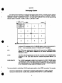
92F0059G
•
c. 3
User Guide
Enuii^crution Areas
Reference Map ScrJea
Can^i^
Canada
Introduction
•
This reference map series shows the boundaries and codes of enumeration areas (EAs). The EAs are
depicted within three distinct types of areas:
1.
Large urban centres (formerly G-13 and G-13A): depict EAs within uriaan centres (census
metropolitan areas and traded census agglomerations) with a population of 50,000 and over. Also
shown are the limits of census tracts (CTs), census subdivisions (CSDs), federal electoral districts
(FEDs) and census metropolitan areas/census agglomerations (CMAs/CAs) — with their corresponding
names, types and/or codes.
2.
Small urban centres (formerly G-14 and G-16): depict EAs within census subdivisions or
unincorporated places. Also shown are the limits of CSDs and FEDs — with their corresponding
names, types and/or codes.
3. Rural areas (formerly G-12): depict EAs within rural areas. Also shown are the limits of CSDs,
census divisions (CDs), FEDs and CMAs/CAs - with their corresponding names and/or codes.
Also available for the large urtsan centres and some of the small urban centres are index maps that
enable users to identify the appropriate map(s) containing the enumeration area(s) of interest. Another
index map is available for EAs within rural areas.
How to Use the Product
#
The maps are designed to enable users to identify the general location and limits of the geographic
areas reported in 1991 Census data publications. The maps should not be used for digitizing purposes
nor to determine the precise location of boundaries. They are not intended to serve as a detailed legal or
cadastral representation of the geographic areas.
Data Quality
The purpose of a data quality statement is to provide detailed infonnation for users to evaluate the
fitness of the data or product for a particular use. Five fundamental components for a quality statement
are: lineage, positional accuracy, attribute accuracy, logical consistency and completeness.
Lineage
Lineage includes descriptions of the source material from which the data were derived and the methods
of derivation, including the dates of the source material and all transformations involved in producing the
final digital files and map products.
Source Material
Census subdivision names, types and boundaries are those that were in effect on January 1,1991 (the
geographic reference date of the 1991 Census). Where notification from provincial or territorial authorities
was not received or was received after March 1991, the name, type and/or limits of CSDs may not
correspond with those recognized by provincial or terrrtorial authorities.
The maps were produced from three sources, using both automated and manual techniques. The
Street Network File (SNF), formeriy called the Area Master File, and the 1991 EA digital boundary file were
used to generate most of the maps within large urtjan centres and some maps within small urtjan centres.
The 1986 EA reference maps were manually updated for those areas not covered by SNF — namely,
portions of large and small urban centres, and rural areas.
The Street Networic Files were digitized at various scales, generally ranging from 1:2,400 to 1:50,000.
The output scales for this map series are 1:15,000 for densely built-up areas and 1:60,000 for sparsely
settled regions.
For the manually-produced maps, the background base map information was obtained from various
source documents. For the large and small uriaan centres not covered by SNF, National Topographic
System (NTS) maps produced by Energy, Mines and Resources Canada (EMR), municipal town plans,
road maps, 1986 census collection maps, and pre-1991 field update maps were used. The map projections
vary depending upon the sources. Compilation scales ranging from 1:2,400 to 1:75,000 were generated
for the large urban centres; the maps were photographically reduced for dissemination (1:4,800 to
1:225,000). The compilation scales for small urban centres ranged between 1:2,400 and 1:250,000.
For rural areas the background base map information was taken from EMR's NTS topographic series
and MCR maps, and from the 1986 census collection maps. The NTS 1:50,000 and 1:250,000 series was
used for the 10 provinces, with map vintages ranging between 1954 and 1990. The map projection is
Transverse Mercator. For the two territories, MCR maps were used; the map scales are 1:1,000,000 for
Yukon and 1:4,000,000 for N.W.T., and the map vintages are 1972 and 1974. The map projection is
Lambert Conformal Conic, with standard parallels at 49°N and 77°N (for Yukon) and at 64°N and 88°N (for
the Northwest Territories).
The 1991 Census Geographic Data Base (CGDB) was used to link the EAs to higher level geographic
areas. This data base contains attribute information for all standard geographical areas, including the
relationships or linkages between these areas.
^ ^
^ B
^ ^
•
Method of Derivation
•
For areas within Street Network File coverage, a "decoupage" method is used in order to provide for
orderiy mapping of areas displayed on many map sheets. The method followed is the "Systeme quebecois
de reference cartographique" (SQRC), which is an extension of the National Topographic System (NTS)
of Canada by systematically forming "sub-decoupages". The SQRC map numbering system is also an
extension of the NTS. Appendix 1 gives further details on the NTS and SQRC. Both systems normally
generate maps that are the same scale as the decoupage scale (i.e. if the decoupage scale is 1:50,000,
the maps are also produced at 1:50,000). This map series deviates somewhat from this approach: for
decoupages at 1:5,000 the plot scale is 1:15,000 and for decoupages at 1:20,000 the plot scale is 1:60,000.
The EAs within the Street Network File coverage were generated by extracting the x,y coordinates of
those physical and cultural features that formed the perimeter of the EAs. The EAs were then formed into
polygons. Higher level geographic areas (CTs, CSDs, CDs, FEDs and CMAs/CAs) were created by rolling
up the EA boundaries.
For mapping purposes within SNF coverage, the Transverse Mercator projection/UTM coordinates were
transformed to Lambert Conformal Conic projection with two standard parallels. In most cases, the
standard parallels for each uriaan centre are separated by two-thirds of the north-south extent of the study
area (i.e. fixed at one-sixth of the total latitudinal extent). This placement serves to distribute the scale en-or
across the map area. The central meridian divides each urban centre in half. In other cases where urban
centres are contiguous or neariy contiguous, the entire area is treated as one entity to position the two
standard parallels and central meridian. These cases include the conurbation in southern Ontario (from
Oshawa to St. Catharines, including some CSDs outside CMAs or CAs) — as well as Saint-Jerome and
Matsqui which use the parameters for the Montreal and Vancouver CMAs respectively.
Some map text was relocated interactively if it overiapped wKh other textual components.
•
The EA linkages to higher level geographic areas (CTs, CSDs, CDs, FEDs and CMAs/CAs) were
determined from the Census Geographic Data Base (CGDB). Refer to the 1991 CGDB Data Quality
Statement (available from the Geography Division).
Positional Accuracy
Positional accuracy is the difference between the "true" position of a feature in the real world and the
"estimated" position stored in the digital file or other product.
Positional accuracy depends on the quality of the source material used (EMR's NTS series and MCR
maps, and the Street Network File, for the position of roads, railroads, rivers, lakes, etc.), as well as the
manual drafting of the base map features and boundaries. The accuracy of higher level geographic areas
is reflected in the roll-up from the 1991 EA digital boundary file. Refer to the 1991 EA Boundary File and
Street Network File Data Quality Statements (available from the Geography Division).
Due to the map scales, it was not always possible to show the actual limits of some small EAs within
the Street Network File coverage. In these cases if an EA polygon was less than or equal to 3000 square
meters, it was depicted by a point symbol.
Attribute Accuracy
Attribute accuracy refers to the accuracy of the non-positional information attached to each feature.
. The 1991 Census Geographic Data Base (CGDB) was used to validate that all EAs were correctly
linked to higher level geographic areas. It was also used to generate the following information: EA codes,
CT names, CSD names and types, CD names, FED codes, and CM/VCA names. Refer to the 1991
CGDB Data Quality Statement (available from the Geography Division).
On the automated maps within the Street Network File coverage, street names are truncated if they
are more than 20 characters, due to historical limitations in record layout specifications. Furthermore,
because of software limitations, SNF feature names do not have French accents.
Each province and territory approves the names of its CSDs, whereas physical features such as lakes
and rivers have official names approved by the Canadian Permanent Committee on Geographical Names
(CPCGN). These maps show the names approved by the CPCGN and the provincial and territorial
authorities.
Names of geographical entities having "pan-Canadian" significance have also been established by the
CPCGN (such as names of provinces, territories, major islands and major bodies of water), and are shown
in both official languages.
Logical Consistency
Logical consistency describes the fidelity of relationships encoded in the data stmcture of the digital
spatial data (i.e. how well elements of the data structure follow the rules imposed on them).
The boundaries were visually checked for closure on the maps produced manually. For the maps
produced by computer, all EA polygons were topologically checked, and a point-in-polygon method was
used to validate both proper labelling as well as linkages to higher level geographic areas. For more
information, refer to the 1991 EA Boundary File Data Quality Statement (available from the Geography
Division).
Completeness
Completeness expressses the degree to which geographic entities (features) are captured according
to the data capture specifications. It also includes information about selection criteria, definitions used and
other relevant mapping rules.
The map series contains 100% of the EAs (45,995) found on the CGDB. Only a subset of features
contained in the Street Network File are displayed on the automated maps. All hydrographic features
(except falls and dams) and transportation features (except proposed highways, highways under
construction, trails, walkways, bridges and tunnels) are shown. Delimiter and associated features are
omitted (e.g. park boundary), as well as most features in the "general" category (except major powerlines,
and cliffs in the Quebec and Hamilton CMAs).
Some textual attribute information may not be depicted due to space limitations. For example, not ail
street names are shown; only those street names that fit on a line segment are plotted in order to avoid
text overiap with crossing street names. Similarly, street types (e.g. Avenue, Crescent) are omitted. In
addition, when polygons are split or truncated by the map frame — resulting in polygon parts too small to
accommodate text labels — the codes and/or names are not shown for these polygons.
For the manually produced maps, all hydrographic and transportation features are depicted.
Other Related Products
The products listed below present information related to this reference map series. Please consult the
1991 Census Catalogue (Catalogue 92-302E) for more information on these and other census products
and services.
92-319
92-320
Not catalogued
Reference Map Series: Census Divisions and Census Subdivisions
Reference Map Series: Census Metropolitan Areas, Census Agglomerations and Census
Tracts
Reference Map:
Federal Electoral Districts (available on request only)
To Obtain IMore Information
Further questions concerning products and sen/ices should be directed to one of the following Statistics
Canada Regional Reference Centres:
St. John's
Halifax
Montreal
Ottawa
Toronto
(709) 772-4073
(902) 426-5331
(514) 283-5725
(613)951-8116
(416) 973-6586
Winnipeg
Regina
Edmonton
Calgary
Vancouver
(204) 983-4020
(306) 780-5405
(403) 495-3027
(403)292-6717
(604) 666-3691
A toll-free number is provided in all provinces and territories, for users who reside outside the local
dialing area of any of the Regional Reference Centres:
Newfoundland and Labrador
Nova Scotia, New Brunswick and Prince Edward Island
Quebec
Ontario
Manitoba
Saskatchewan
Alberta
Southern Alberta
British Columbia (South and Central)
Yukon and Northern B.C. (area sen/ed by NORTHWESTEL Inc.)
Northwest Territories (area served by NORTHWESTEL Inc.)
Telecommunications Device for the Hearing Impaired
1-800-563-4255
1-800-565-7192
1-800-361-2831
1-800-263-1136
1-800-542-3404
1-800-667-7164
1-800-282-3907
1-800-472-9708
1-800-663-1551
Zenith 08913
Call collect 403-495-3028
1-800-363-7629
•
Appendix 1
Decoupage System
The diagram below illustrates the National Topographic System (NTS) of Canada and the Systeme
quebecois de reference cartographique (SQRC). The NTS includes map scales at 1:1,000,000,1:500,000,
1:250,000, 1:125,000, 1:50,000 and 1:25,000. The SQRC is an extension of the NTS for representing
areas at scales of 1:20,000, 1:10,000, 1:5,000, 1:2,000 and 1:1,000.
.
I
1:20 000
1:50 000
PHI
. 1:250 000
1:1 000 000 .
'^ I '5 I 16
11
to
T M -
N
K
21
H
21
A primary NTS quadrangle of the 1:1,000,000 series, numbered successively 21,
22, 23.... Each quadrangle extends 4" of latitude and 8° of longitude.
21M
The NTS primary quadrangle is divided into 16 sheets for the 1:250,000 series,
lettered A to P. Each sheet is designated by the primary quadrangle number
followed by a letter.
21M13
The NTS 1:250,000 quadrangle is divided into 16 sheets for the 1:50,000 series,
numbered 1 to 16. Each sheet takes the 1:250,000 designation followed by a
number.
21 Ml 3-200-0101
The 1:50,000 quadrangle is divided into 4 sheets for the SQRC 1:20,000 series
- numbered 0101 (S.W.), 0102 (S.E.), 0201 (N.W.) and 0202 (N.E.). The number
200, inserted between the 1:50,000 designation (21 Ml 3) and 1:20,000 designation
(0101), represents the map scale when multiplied by 100.
The same principle for subdividing 1:50,000 quadrangles applies to other SQRC map scales. For example:
- there are 16 sheets for the 1:10,000 series, numbered 21 Ml 3-100-0101 to 21 Ml 3-100-0404.
- there are 64 sheets for the 1:5,000 series, numbered 21 Ml 3-050-0101 to 21 Ml3-050-0808.
•
Appendix 2
Definitions
The definitions of geographic terms and census concepts are presented here in summary form only.
Please refer to the 1991 Census Dictionary (Catalogue 92-301E) for the full definitions.
Census Agglomeration (CA): The general concept of a CA is one of a large urtaan area, together with
adjacent urtaan and rural areas which have a high degree of economic and social integration with that urban
area.
A CA is delineated around an uriaan area (called the uriaanized core and having a population of at least
10,000, based on the previous census). Once a CA attains an urtaanized core population of at least
100,000, based on the previous census, it becomes a census metropolitan area (CMA).
Census Division (CD): Refers to the general term applying to geographic areas established by provincial
laws which are intermediate geographic areas between the census subdivision and the province (e.g.
divisions, counties, regional districts, regional municipalities and seven other types of geographic areas
made up of groups of census subdivisions).
In Newfoundland, Manitoba, Saskatchewan and Alberta, provincial law does not provide for these
administrative geographic areas. Therefore, CDs have been created by Statistics Canada in co-operation
with these provinces.
Census Metropolitan Area (CMA): The general concept of a CMA is one of a very large urban area,
together with adjacent urban and rural areas which have a high degree of economic and social integration
with that urban area.
A CMA is delineated around an urban area (called the urbanized core and having a population of at
least 100,000, based on the previous census). Once an area becomes a CMA, it is retained in the program
even if its population subsequently declines.
Smaller urban areas, centred on urbanized cores of a population of at least 10,000, are included in the
census agglomeration (CA) program.
Census Subdivision (CSD): Refers to the general term applying to municipalities (as determined by
provincial legislation) or their equivalent, e.g. Indian reserves, Indian settlements and unorganized
territories.
In Newfoundland, Nova Scotia and British Columbia, the term also describes geographic areas that
have been created by Statistics Canada in co-operation with the provinces as equivalents for municipalities.
Census Subdivision Type: The type indicates the municipal status of a census subdivision. CSDs are
classified into various types, according to official designations adopted by provincial or federal authorities.
The following list indicates all CSD types and their abbreviations:
BOR
C
CM
COM
CT
CU
DM
HAM
ID
Borough
City - Cite
County (municipality)
Community
Canton (municipalite de)
Cantons unis (municipalite de)
District municipality
Hamlet
Improvement district
IGD
LGD
LOT
MD
NH
NV
P
PAR
R
Indian government district
Local government district
Township and royalty
Municipal district
Northern hamlet
Northern village
Paroisse (municipalite de)
Parish
Indian reserve - Reserve indienne
RM
RV
SA
SCM
SD
S-E
SET
SRD
SUN
SV
Rural municipality
Resort village
Special area
Subdivision of county municipality
Sans designation (municipalite)
Indian settlement - feablissement indien
Settlement
Subdivision of regional district
Subdivision of unorganized
Summer village
T
TP
TR
UNO
V
VC
VK
VL
VN
Town
Township
Terres reservees
Unorganized - Non organise
Ville
Village cri
Village naskapi
Village
Village nordique
Census Tract (CT): The general concept of a CT is that of a permanent, small urban neighbourhood-like
or rural community-like area established in large uriaan-centred regions with the help of local specialists
interested in urban and social science research.
Census tracts are delineated jointly by a local committee and Statistics Canada. The population must
be between 2,500 and 8,000, with a preferred average of 4,000 persons (except for those CTs in central
business districts, in other major commercial and industrial zones, or in peripheral rural or urisan areas that
may have either a lower or higher population). Also, when first delineated or subsequently subdivided, CTs
must be as socio-economically homogeneous and compact in shape as possible.
All CMAs and CAs in Canada containing a CSD having a population of 50,000 or more at the previous
census are eligible for a census tract program.
Enumeration Area (EA): An EA is the geographic area canvassed by one census representative. The
number of dwellings in an EA generally varies between a maximum of 375 in large urban areas to a
minimum of 125 in rural areas. An EA always respects higher level geographic areas recognized by the
census, and is the smallest unit for which census data are usually available.
Federal Electoral District (FED): A FED refers to any place or territorial area entitled to return a member
to serve in the House of Commons. There are 295 FEDs in Canada according to the 1987 Representation
Order. FED legal limits and descriptions are the responsibility of the Chief Electoral Officer, and are usually
revised every 10 years after the results of the decennial census.
Geographic Area: Refers to geographic areas delineated or employed for the collection, compilation,
analysis and dissemination of census data.
Province: Refers to the major polHical division of Canada. From a statistical point of view, it is a basic unit
for which data are tabulated and cross-classified.
Reference Maps: Reference maps are maps which show the locations and boundaries of the geographic
areas for which census data are tabulated and published. The main information depicted on reference
maps includes the boundaries, names and codes of census geographic areas, and major cultural and
physical features such as roads, railways, rivers and lakes.
Standard Geographical Classification (SGC): The SGC is Statistics Canada's official classification of
geographic areas in Canada. The SGC provides unique numeric identification for three types of geographic
areas: provinces and territories; census divisions; and census subdivisions.
The three geographic areas are hierarchically related. CSDs aggregate to CDs, which in turn
aggregate to a province or territory. This relationship is reflected in the seven-digit code:
Province/territory
XX
2 digits
Census division
Census subdivision
XX
2 digits
XXX
3 digits
Street Networic File (SNF): The SNF, formerly known as the Area Master File (AMF), is a computerreadable file that geographically references the street network and selected other non-street features (such
as rivers, lakes, railways and municipal limits). SNFs are generally created for urtaan municipalities which
had a population of 50,000 or more at the previous census and for which census tracts have been defined.
The SNF contains the names for all street and non-street features. In addition, the intersection (corner)
civic address ranges and block-face representative points are available for addressable streets.
Territory: Refers to two major political divisions of Canada, namely Yukon Territory and Northwest
Territories. From a statistical point of view, these territories are equivalent to provinces, i.e. a basic unit
for which data are tabulated and cross-classified.
Unincorporated Place (UP): The concept of a UP is a cluster of dwellings (i.e. a settlement) lacking legal
limits or local government. A UP has a cluster of five or more occupied dwellings in rural areas, and is
locally known by a specific name. A UP has the same Standard Geographical Classification code as the
CSD in which it is located.