1
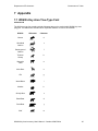
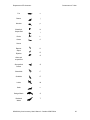
Yukon Wildlife Key Area Inventory
User’s Manual
October 2009
Habitat Programs Section
Fish and Wildlife Branch
Department of Environment
Government of Yukon
Department of Environment
Government of Yukon
Table of Contents
1
INTRODUCTION .................................................................................................................................2
2
THE YUKON WILDLIFE KEY AREA INVENTORY ....................................................................2
2.1
THE WILDLIFE KEY AREA INVENTORY IN THE YUKON HABITAT PROGRAMS SECTION ........................2
2.2
WHAT ARE KEY AREAS? ......................................................................................................................2
2.3
WHY IDENTIFY KEY AREAS? ...............................................................................................................3
2.4
HOW ARE KEY AREAS IDENTIFIED AND MAPPED? ...............................................................................3
2.4.1
Data Source .................................................................................................................................3
2.4.2
Mapping Methods and Criteria ...................................................................................................3
2.4.3
WKA Mapping Level....................................................................................................................4
2.5
LIMITATIONS ........................................................................................................................................4
3
WILDLIFE KEY AREA CRITERIA ..................................................................................................5
3.1
SUMMARY: YUKON WILDLIFE KEY AREAS ..........................................................................................5
3.1.1
Season codes................................................................................................................................7
3.1.2
Function codes.............................................................................................................................7
3.2
SPECIES AND TAXONOMIC GROUP CRITERIA ........................................................................................8
3.2.1
Moose ..........................................................................................................................................8
3.2.2
Woodland Caribou ......................................................................................................................9
3.2.3
Barren-ground Caribou...............................................................................................................9
3.2.4
Thinhorn Sheep..........................................................................................................................10
3.2.5
Mountain Goat...........................................................................................................................10
3.2.6
Mule Deer..................................................................................................................................11
3.2.7
Elk..............................................................................................................................................11
3.2.8
Wood Bison................................................................................................................................12
3.2.9
Muskox.......................................................................................................................................12
3.2.10 Mineral Licks.............................................................................................................................13
3.2.11 Grizzly Bear...............................................................................................................................13
3.2.12 Black Bear .................................................................................................................................14
3.2.13 Polar Bear .................................................................................................................................14
3.2.14 Wolf ...........................................................................................................................................15
3.2.15 Fox.............................................................................................................................................15
3.2.16 Beaver........................................................................................................................................16
3.2.17 Muskrat......................................................................................................................................16
3.2.18 Waterfowl ..................................................................................................................................17
3.2.19 Raptors ......................................................................................................................................18
3.2.20 Sharp-Tailed Grouse .................................................................................................................18
3.2.21 Shorebirds..................................................................................................................................19
3.2.22 Seabirds .....................................................................................................................................19
3.2.23 Larids.........................................................................................................................................20
3.2.24 Seal ............................................................................................................................................20
3.2.25 Beluga Whale.............................................................................................................................21
3.2.26 Bowhead Whale .........................................................................................................................21
4
WIDLIFE KEY AREA INVENTORY PRODUCTS .......................................................................22
5
THE WILDLIFE KEY AREA INVENTORY USER AGREEMENT............................................23
6
MORE INFORMATION? ..................................................................................................................24
7
APPENDIX ..........................................................................................................................................25
7.1
7.2
WILDLIFE KEY AREA TRUE-TYPE FONT ............................................................................................25
WILDLIFE KEY AREA POLYGON MAPPING AND PROJECTION .............................................................27
Wildlife Key Area Inventory User’s Manual – October 2009 Edition
1
Department of Environment
Government of Yukon
1 Introduction
This document describes the Wildlife Key Area (WKA) Inventory, including an overview of the
Inventory, criteria used to identify WKAs, and a list of available WKA products. It also contains the
end-user licence agreement, which all users of WKA Inventory products are expected to adhere
to.
The WKA Inventory data are available in various formats to support specific users or GIS
technology. Technical information pertaining to each format is available in separate documents
distributed with each format.
2 The Yukon Wildlife Key Area Inventory
2.1 The Wildlife Key Area Inventory in the Yukon Habitat
Programs Section
The Habitat Programs Section of the Yukon Department of Environment works to ensure that
there is enough good quality habitat to maintain wildlife populations. Inventory is a priority, since
all other components of the program depend on current and detailed information about wildlife
habitat.
A major goal of the Habitat Programs Section is to catalogue the location, distribution and
abundance of key areas for legally harvested and protected wildlife species.
Wildlife Key Area is a concept devised and adopted by the Department of Renewable Resources
back in 1988 to inventory locations important to populations of legally harvested and protected
wildlife species. The WKA Inventory Program evolved from a manual, hand-drawn map system
to a fully digital, spatial, relational database system currently managed and maintained by Yukon
Department of Environment, Habitat Programs Section.
2.2 What are Key Areas?
Wildlife Key Areas are geographical locations used by wildlife for critical, seasonal life functions.
Each wildlife species use these specific areas for a distinct purpose. For example, in winter
thinhorn sheep forage on grasses and forbs only available on limited winter ranges. Many
species like sheep use key areas traditionally, around the same time each year, while others (e.g.
moose) will use them only occasionally when they are forced to by factors such as severe
weather. Often animals aggregate on key areas in relatively large numbers, making populations
vulnerable to disturbance or direct habitat loss. So, in general, if key areas are destroyed or the
animals using them are disturbed the population would decrease, as would its likelihood of
survival. Key areas need to be protected to maintain the health and sustainability of wildlife
populations.
The key area concept does not apply well to all species. It is ideal for species that use key areas
seasonally each year, such as thinhorn sheep. Mapping key areas for species such as grizzly
bear is much more difficult, because they have large home ranges and/or do not use habitat in an
easily defined way (e.g., grizzly bear). For other predatory species, such as lynx, coyote, and
wolverine, key area has yet to be defined. It may be possible in the future to identify their key
areas by locating places abundant with their prey.
Wildlife Key Area Inventory User’s Manual – October 2009 Edition
2
Department of Environment
Government of Yukon
2.3 Why Identify Key Areas?
Wildlife populations can use a significant amount of habitat other than WKAs, but it is not possible
to prevent all activities that impact the land and wildlife. The WKA Inventory serves to focus
mitigation/protection efforts to those areas that are limited in availability, most valuable to the
species/population, and/or where wildlife is most vulnerable. With the help of land managers and
wildlife & habitat biologists, developers can plan their activities to avoid key areas altogether or
during periods of critical use.
The WKA inventory is currently used in the Land Use Application Review process by Yukon
Environmental & Socio-economic Assessment Board (YESAB). Depending on the land use
activity, specific recommendations are made to maintain key areas and reduce impacts. The land
use guidelines developed for key areas tell land users when, where, and under what conditions
land use activities should occur. In addition, the Land Use Application Review process through
YESSA(Act) is improved, because land use proponents that obtain key area information can tailor
proposals to reduce conflicts and shorten review times.
The WKA Inventory is also useful for land use planning, which requires an inventory and
assessment of multiple reaource interests. Land use planning usually involves determining the
highest value of the land based on its capability and on the opinions and desires of local people.
2.4 How are Key Areas Identified and Mapped?
Key areas for most species are given a boundary primarily through assessing animal location
during key seasons of use. Mapping the known locations of sheep in winter, for example,
identifies their winter range. Definitions of WKA for a species/taxon group are discussed in
more detail in section 3.
2.4.1 Data Source
Wildlife surveys are the primary source for delineating seasonal distribution and key areas. But
other significant sources used to locate animals and their key areas include interviews with
knowledgeable locals and biologists, published and unpublished literature and/or maps, and
hunting and trapping statistics.
While survey data can provide accurate locations from which to interpret WKAs, it can often be
limited in quantity, providing a narrow view of a population’s use of the landscape. But as
surveys are repeated from year to year, the ability to capture the full picture improves. Local
knowledge or anecdotal information, while sometimes more general, can date further back in time
giving a historic perspective and provide the bigger picture of what is actually happening on the
land. Both data sources are complimentary and valuable to WKA interpretation.
2.4.2 Mapping Methods and Criteria
In the late 1980’s and early 1990’s WKA mapping was done primarily by free-hand drawing on
paper maps and transcribing to mylar. This method was prone to user subjectivity. With the
advent of GIS and database management systems, more systematic and robust mapping
methods were devised. The improved ability to apply data queries, buffering techniques, and
other GIS functionality removed much of the subjectivity.
Mapping methods and criteria varies between species or taxon group and/or populations.
Possible criteria include relative distribution (e.g. proximity: excluding data outside a specified
nearest-neighbor distance threshold), density (e.g. animals/unit area: beaver and muskrat),
Wildlife Key Area Inventory User’s Manual – October 2009 Edition
3
Department of Environment
Government of Yukon
sensitivity (e.g. ranking), rareity (e.g. threatened or endangered species: muskox and wood
bison), and geographical (e.g. latitudinal: moose in North Yukon).
Generating key area polygons (i.e. mapping methods) from queried data often used buffer
thresholds that depended on species or population characteristics. Methods have evolved
recently to use home range analysis tools within GIS, and applying these on seasonal data sets.
Local knowledge, on the other hand, involves directly importing an interviewee’s identified key
areas as-is into the GIS system.
2.4.3 WKA Mapping Level
Recently integrated in this version of WKA is the concept of “Level”. There are 3 Levels defined
in the WKA Inventory and database. Level 1 include the specific locations used to delineate key
areas. These data are not included in the WKA database, as they are usually captured as points
from wildlife surveys and maintained by other databases. Level 2 data are key areas derived
from Level 1 source data, and are the primary representation of key areas for management
decisions. Level 3 key areas are a more generalized representation suitable for smaller scale
mapping and broad-based management initiatives (e.g. State of the Environment reporting).
A species or taxon group may or may not have both Levels of data. Often Level 2 key areas are
nested within Level 3 key areas, for a given taxon group or population (e.g. woodland caribou).
For some species or taxon groups Level 3 key areas are the sole representation of key areas.
For example, wood bison key areas are currently represented as Level 3 only until suitable Level
2 methods are defined and implemented. Some sensitive Level 2 key areas are withheld from
public release, while the more general Level 3 interpretation that obscures the true location of the
feature is available (e.g. mineral licks).
2.5 Limitations
When using WKA data it is easy to assume that all the key areas for a species within a region are
identified. But in actuality the data only include those areas we know about. It is important to
recognize these data gaps.
Much of the Yukon has not been surveyed intensively, or surveys that have been done were not
at key times of year. Furthermore, surveys are but one source for delineating WKAs. First Nation
and other people that travel on the land know a great deal about wildlife distribution, and most of
this knowledge has not been captured in the WKA inventory.
It is also important to consider the scale when using the maps. Key Area polygons are compiled
against 1:250,000 scale National Topographic Database (NTDB), Natural Resources Canada. It
is not appropriate to re-map the areas on to a larger scale, that is, to transfer the areas from the
1:250,000 scale to 1:50,000 scale. This process results in increased accuracy of the boundaries
that is not based on knowledge. On the other hand, there is no problem with reducing the
precision of the lines by re-mapping at a smaller scale, but in some instances generalization of
the polygons would be useful to reduce unnecessary detail.
Another important consideration is that the WKA Inventory does not include a detailed habitat
suitability assessment of the land. Specific habitat features are not used to identify key areas,
rather animal observations delineate the area. Only general knowledge about biophysical factors
that influence habitat use patterns are used to “fine tune” key areas. For example, when sheep
are located in winter it is known that they are using primarily south-facing, wind swept slopes that
are clear of snow. Key area boundaries are refined based on inferences about the extent of nearby habitat being used by the observed sheep.
Wildlife Key Area Inventory User’s Manual – October 2009 Edition
4
Department of Environment
Government of Yukon
3 Wildlife Key Area Criteria
The critical, seasonal life functions for each species or taxon group were defined through
extensive literature reviews and consultation with species biologists. The table below summarizes
the key life cycle features defined for Yukon wildlife species and shows the map symbols used.
The rationale for which seasonal life functions were considered key for each species or
taxonomic group is described in the sections that follow.
3.1 Summary: Yukon Wildlife Key Areas
Key Area Map Label Symbols
Wildlife
Key Area Type
Moose
Late Winter Range
Summer Range (Old
Crow Flats)
Year-Round, All
Functions(North
Yukon)
Woodland
Caribou
Barrenground
Caribou
Winter Range
Fall Rut
Migration Corridor
Winter Range
Spring Calving
Summer Insect Relief
Migration Corridor
Thinhorn
Sheep
Winter Range
Spring Lambing
Early Winter Rut
Migration Corridor
Mountain
Goat
Year-Round, All
Functions
Mule Deer
Winter Range
Year-Round, All
Functions
Elk
Year-Round, All
Functions
Wood Bison
Year-Round, All
Functions
Silhouette
Season
Function
d
lw
s
R
R
y
A
w
f
sp, f
R
B
C
w
sp
s
sp, f
R
X
I
C
w
sp
ew
sp, f, u
R
X
B
C
y
A
w
y
R
A
y
A
y
A
c
f
b
a
e
g
i
Wildlife Key Area Inventory User’s Manual – October 2009 Edition
5
Department of Environment
Muskox
Winter Range
Fall Rut
All the Above
Mineral Lick
Grizzly Bear
Major Feeding Range
Black Bear
Major Feeding Range
Polar Bear
Denning Area
Wolf
Denning Site
Fox
Denning Area
Beaver
Year-Round, All
Functions
(high density area)
Muskrat
Year-Round, All
Functions
(high density area)
Waterfowl:
Unspecified
Spring Staging
Summer Nesting
Summer Moulting
Fall Staging
Ducks
Geese
Swans
Raptors:
Alpine
Summer Nesting
Riparian
Other and
unspecified
Sharp-tailed
Grouse
Year-Round, All
Functions
Government of Yukon
h
w
f
R
B
no symbol
y, s, u
L
y (sp, s, f)
R
y (sp, s, f)
R
w
D
sp, s
D
sp, s
D
y
A
y
A
sp
s
s
f
S
X
M
S
s
X
y
A
x
A
y
m
o
j
p
N
I
L
C
K
D
O
G
Wildlife Key Area Inventory User’s Manual – October 2009 Edition
6
Department of Environment
Shorebirds
Summer Nesting
Summer Brood
Rearing
Fall Staging
Seabirds
Summer Nesting
Fall Staging
Larids
Summer Nesting
Summer Brood
Rearing
Fall Staging
Seals
Beluga Whale
Bowhead
Whale
Year-Round, All
Functions
Migration Corridor
Summer Range
Fall Range
Government of Yukon
F
E
M
u
S
T
s
s
X
Y
f
S
s
f
X
S
s
s
X
Y
f
S
y
A
sp, f
C
s
f
R
R
3.1.1 Season codes
w
ew
lw
sp
s
f
y
u
winter (October - April)
early winter (October - January)
late winter (February - April)
spring (April - June)
summer (June - August)
fall (August - October)
year round
unknown
3.1.2 Function codes
R
B
X
D
I
S
M
Y
C
A
L
range (i.e. feeding area)
breed (e.g. rutting area, courting area)
reproduction (e.g. lambing area, nesting area)
den
insect relief
stage (i.e., migratory stop-over area)
moult
rear young
migration corridor
all functions
mineral lick
Wildlife Key Area Inventory User’s Manual – October 2009 Edition
7
Department of Environment
Government of Yukon
3.2 Species and Taxonomic Group Criteria
3.2.1 Moose
Winter can be a stressful season for many species, including moose. Moose are affected
primarily by the difficulties in travelling through deep snow and having to dig through snow to
reach the shrubs on which they feed. Because snow gets deeper over the winter, the critical
period when moose must move to special habitats is late winter. For much of the Yukon, key late
winter range is considered to be areas where moose gather between January and April that
have relatively shallow snow depths and abundant browse.
River valleys are typical of late winter habitats. The bands of shrubs and poplar near the river
provide browse for the moose. Adjacent upland mature spruce forests have a dense canopy that
intercepts a significant amount of snow fall that would otherwise accumulate on the ground, so
moose use these stands as travel corridors and for cover. Moose that inhabit mountainous areas
are particularly likely to move to and from late winter ranges. Here, moose descend from subalpine shrub communities to mixed spruce-shrub forests found in valley bottoms and/or river
valley floodplains.
In many areas of the Yukon the average annual snowfall is not deep enough to cause moose to
move to special late winter ranges. In years of low snow depth disturbed sites such as burns or
logged areas and stands of tall shrubs are heavily utilized. Late winter range is key only during
years of significant snowfall (i.e. greater than 70 cm). But even though this may happen only
once every ten years in some regions of the Yukon, identifying and protecting late winter ranges
is necessary to provide moose with safe areas to weather these difficult times.
Moose key area is defined differently for the northern Yukon. Here, year-round range is
considered key for moose, because suitable habitat is limited. In a landscape dominated by
tussock tundra and where forested areas are scarce, moose are found primarily in shrub habitats
throughout the year. This habitat type is mainly limited to narrow bands along rivers, streams and
gullies, and represents only about 5% of the North Slope landscape.
Relatively high concentrations of moose are known to use Old Crow Flats in summer.
Characteristic of this transitional, forest-tundra wetland are white spruce/tall willow communities
that line major drainages, and extensive upland shrub & wet meadows. Moose are attracted to
the shallow lakes and ponds that have abundant aquatic vegetation. Moose migrate into the
wetlands from the southeast Brooks Range in Alaska starting late March and move out of the flats
in late August. This population, shared between Canada/U.S., has one of the largest recorded
migratory distances for moose in AK and NW Canada (mean max dist 123km).
The traditional use of calving sites by adult cows may be quite important. For example, some
islands seem to be heavily used for calving by moose. Since these sites are not usually identified
during moose surveys, we will depend on local knowledge for information on key calving sites.
These will be mapped as they are obtained.
Key Area Map Label Symbols
Key Area Type
Silhouette
Late Winter Range
Summer Range (Old
Crow Flats)
Year-Round Range
(North Yukon)
d
Season
Function
lw
s
y
R
R
A
Wildlife Key Area Inventory User’s Manual – October 2009 Edition
8
Department of Environment
Government of Yukon
3.2.2 Woodland Caribou
Winter range, migration corridors, and rutting areas have been identified as key for woodland
caribou. These habitat types are all used traditionally. Calving areas are also used consistently,
but are not considered key because cows bearing young are solitary and widely dispersed.
However, there is increasing evidence that post-calving range may be key for at least some
woodland caribou herds, as cows and their calves appear to congregate in areas of high quality
forage. These will be mapped where the information is available.
During the fall rut, woodland caribou aggregate in traditional areas for about one month. These
areas are typically located at higher elevations in open, alpine/sub-alpine communities.
As winter progresses, woodland caribou become particularly vulnerable. Cold temperatures are
not a problem for caribou, but deep, hard packed snow interferes with feeding, makes travelling
difficult, and under certain conditions can inhibit escape from predators. Snow conditions
become more unfavourable for woodland caribou as winter progresses. In response, they move
along traditional routes or migration corridors to forests and, in moderate winters, subalpine shrub
areas where snow conditions are less severe and where lichens, their primary food, are more
readily available.
It is the discrete use of winter ranges that have enabled biologists to recognize 23 distinct
woodland caribou herds. Together these herds occupy nearly all of the south and central Yukon.
Key Area Map Label Symbols
Key Area Type
Winter Range
Fall Rut
Migration Corridor
Silhouette
c
Season
Function
w
f
sp, f
R
B
C
3.2.3 Barren-ground Caribou
Key areas for barrenground caribou include calving grounds, post-calving range, and insect
relief areas. These definitions are based on work done on the Porcupine Caribou Herd. There
are two major barrenground caribou herds in the Yukon.
The Porcupine Caribou Herd is the largest and ranges over most of the northern Yukon and into
Alaska. The Fortymile Herd is much smaller and due to past severe overhunting now occurs
mainly in Alaska, although it used to occupy the entire southwest Yukon. If herd growth
continues it is expected to soon re-occupy its former Yukon range west of Dawson. Key area
definitions may change when this occurs.
Calving grounds and post-calving range occur where there is abundant high quality forage and
the onslaught of insects is delayed.
Insect harassment in the summer (primarily by mosquitoes) can have a significant impact on
barrenground caribou in the northern Yukon. In response to harassment herds will seek windy
areas, such as coastal and mountainous regions, or snow patches.
Key Area Map Label Symbols
Key Area Type
Silhouette
Season
Function
Wildlife Key Area Inventory User’s Manual – October 2009 Edition
9
Department of Environment
Winter Range
Spring Calving
Summer Insect Relief
Migration Corridor
Government of Yukon
f
w
sp
s
sp, f
R
X
I
C
3.2.4 Thinhorn Sheep
Dall (white) and Stone (dark) sheep are two subspecies of thinhorn sheep found in the Yukon.
Fannin sheep, a unique colour-phase of Dall sheep , is also found in the territory. Thinhorn
sheep are very traditional users of winter ranges, lambing areas, rutting grounds, and
migration corridors. All these habitats are key because they are used traditionally, and are
limited in extent.
Generally, winter ranges are found on steep, south-facing slopes where strong winds and
sunshine prevent snow accumulation. In early winter sheep are not significantly restricted by
snow because it is usually soft enough to allow movements and cratering. As winter progresses
the snow becomes wind-packed, and sheep are confined and concentrated into smaller snowfree, wind-blown areas where forage is available.
Lambing, which occurs between May and early June, is a key time of year for ewes and lambs.
During lambing, they are vulnerable to predation, primarily by wolves, coyotes, grizzly bears, and
golden eagles. To avoid predators ewes will give birth on steep cliff faces. These areas are used
traditionally for lambing but may also be used as predator escape terrain during other seasons.
Small groups of sheep use rutting, or mating, grounds in early winter. The locations and physical
characteristics of rutting grounds are not well known, but the behaviour itself is more significant
than the location. Preventing the disturbance of these rutting groups is important to ensure
successful reproduction. More research is required to better define the physical attributes of
rutting grounds.
Sheep travel along well-worn migration routes to access summer and winter ranges, mineral
licks, and other key habitats. If there is a significant disturbance along these migration trails or
they are destroyed, sheep populations could be prevented from reaching important areas within
their total range.
Key Area Map Label Symbols
Key Area Type
Winter Range
Spring Lambing
Early Winter Rut
Migration Corridor
Silhouette
b
Season
Function
w
sp
ew
sp, f, u
R
X
B
C
3.2.5 Mountain Goat
Year-round, all functions has been identified as key for mountain goats, because goats and
their habitat are uncommon and not well studied in the Yukon. Sites for all important life
functions, such as winter range, kidding areas, and rutting grounds are included within key area
boundaries. Mountain goats prefer high elevations on steep slopes with escape, or cliff, terrain
nearby. Winter range is predominantly located on south-facing slopes and cliffs, and on high
ridge areas where sun and wind limit snow accumulation. Kidding occurs on rugged, steep
Wildlife Key Area Inventory User’s Manual – October 2009 Edition
10
Department of Environment
Government of Yukon
terrain.
The central Yukon is the northern-most location of the North American mountain goat. Their
distribution in the Yukon is not extensive, primarily because of habitat limitations. Mountain goats
are found in rugged, mountainous regions most often associated with intrusive and metamorphic
bedrock groups; these rock types provide more stable footing than sedimentary rock. They also
prefer areas with substantial precipitation, such as found in the St. Elias Mountains and YukonStikine Highlands ecoregions.
Key Area Map Label Symbols
Key Area Type
Year-Round, All
Functions
Silhouette
Season
Function
a
y
A
3.2.6 Mule Deer
Year-round, all functions for mule deer is considered to be key, because mule deer occur in low
numbers and are designated as “specially protected wildlife” under the Yukon Wildlife Act. Some
winter ranges have also been identified. In the Yukon, mule deer are commonly found in burn
areas and on exposed, south facing slopes. They prefer relatively dry sites, in which there is a
diversity of habitat types such as grasslands, aspen stands, and white spruce or pine stands.
Mule deer populations are limited by the availability of forage, water, and cover, particularly
during the winter.
Key areas were mapped mainly from reported sightings. Burn areas were also mapped as key
mule deer habitat when deer observations within these areas were common. The definition of
what areas are key for mule deer in the Yukon could change if and when intensive studies to
identify deer population status and seasonal habitat use are completed.
Key Area Map Label Symbols
Key Area Type
Winter Range
Year-Round Range
Silhouette
Season
Function
e
w
y
R
A
3.2.7 Elk
Year-round, all functions is identified as key for elk because of their low numbers and because
the species is designated as “specially protected wildlife” under the Yukon Wildlife Act. Elk, not
being indigenous to the Yukon, were introduced in 1951 and 1954 by Yukon Department of
Renewable Resources and Yukon Fish and Game Association.
Elk live in two small but distinct herds, one in the Takhini River valley and the second in Hutshi
Lake/Nordenskiold valley. The herd’s core range (i.e. where 90% of the elk sightings occur) was
used to define year-round distribution. The core range includes habitats that support important
life functions, such as calving grounds, rutting areas, and winter ranges.
Elk prefer habitats that have immature forests interspersed with grasslands, meadows, or open,
south-facing slopes. This mosaic of habitat types provides a large amount of edge habitat where
the quantity and diversity of forage is greatest. Elk frequent exposed south-facing slopes in
winter, where snow accumulation is low and amounts of forage and nutrient levels are relatively
Wildlife Key Area Inventory User’s Manual – October 2009 Edition
11
Department of Environment
Government of Yukon
high. South-facing slopes are critical to elk in the spring, since early green-up provides the first
source of high quality forage. Elk use forested habitats for shelter throughout the year.
Key Area Map Label Symbols
Key Area Type
Year-Round, All
Functions
Silhouette
Season
Function
g
y
A
3.2.8 Wood Bison
Year-round, all functions is mapped as key for wood bison, because this species is declared as
“specially protected wildlife” under the Yukon Wildlife Act and only occurs in low numbers. Wood
bison were extirpated from many parts of their range and disappeared from the Yukon 800 - 1000
years ago. In 1975 a Canadian Wood Bison Recovery Program involving federal, provincial, and
territorial governments was initiated with the objective of re-establishing free roaming herds of
wood bison. This program came to the Yukon in 1980.
The initial phase of the project was to determine habitat potential for wood bison in the Yukon.
The Nisling River valley was selected as the most favourable area for bison relocation. In March
1986 wood bison from Elk Island National Park were brought to the Nisling River valley and
placed in a corral. Two years later most of these bison were released into the wild. Since that
time more bison were brought in and released, and a herd is now becoming well established in
the Nisling River valley and the Aishihik Lake area.
Key area mapping for the herd is based primarily on relocation and census surveys. The mapped
key areas of the bison herd will likely change as more data becomes available. Also, the
distribution of the bison may continue to change, as it is still a relatively young and unsettled
population. In future, methodology will be applied to map bison seasonal distribution.
Key Area Map Label Symbols
Key Area Type
Year-Round, All
Functions
Silhouette
Season
Function
i
y
A
3.2.9 Muskox
Winter range and fall rut is mapped as key for muskox, based on reported sightings, surveys
and satellite collar relocations. In winter they frequently use areas with shallow snow cover, such
as ridges, hillsides, and uplands. In the growing season muskox prefer riparian areas with an
abundance of willows, their primary food. In Yukon most observations of muskox are made on
the coastal plain and along major river drainages of the North Yukon. Muskox have only recently
occupied the North Slope.
Muskox are believed to have inhabited the Arctic coasts of Alaska and the Yukon before being
extirpated from these areas in the mid-1800’s. In an attempt to reintroduce this species in
Alaska, 51 muskoxen were released on Barter Island in 1969, 120 km northwest of the Yukon
border. In 1985 the population had increased to 476 animals. Breeding populations are
becoming established, and continued expansion of muskox herd size and range can be expected
on the Yukon’s North Slope.
Wildlife Key Area Inventory User’s Manual – October 2009 Edition
12
Department of Environment
Government of Yukon
Key Area Map Label Symbols
Key Area Type
Silhouette
Season
Function
h
w
f
R
B
Winter Range
Fall Rut
3.2.10 Mineral Licks
All Yukon ungulates (moose, caribou, sheep, goats, deer, elk, bison, and muskox) as well as
some other animals use mineral licks. Mineral licks, which are scattered throughout the Yukon,
provide animals with essential minerals such as sodium, magnesium and trace elements.
Different animals use different types of mineral licks. For example, sheep and goats usually use
dry earth exposures, whereas moose and caribou generally prefer wet muck licks and mineral
springs.
Mineral licks appear to have a profound effect on ungulate distribution and movement patterns.
Sheep, for example, have been known to travel many kilometres to visit mineral licks seasonally.
There have been no specific biological surveys for mineral licks in the Yukon; rather, mapping
sources included scientific studies, incidental observations during wildlife surveys, observations
by knowledgeable locals, and outfitter questionnaires.
Given the fixed location of mineral licks and traditional, seasonal use, animals using them can be
vulnerable to harvesting. So the exact location of mineral licks is concealed within a Level 3
representation. More detailed Level 2 data are referred to confidentially by managers to mitigate
the impact of land use activities at these important sites.
Key Area Map Label Symbols
Key Area Type
Mineral Lick
Silhouette
Season
Function
no symbol
y, s, u
L
3.2.11 Grizzly Bear
Key areas for grizzly bears may be mapped as spring, summer, or fall range or as year-round
range, because of lack of information on season of use. It includes areas where they
concentrate seasonally, such as natural feeding areas and movement corridors. Grizzly bears
are known to feed in the same berry areas each year. They also concentrate seasonally along
major salmon spawning rivers. The key area maps identify only a few areas of grizzly bear
concentration; more study is required to complete this mapping.
Grizzly bear key areas tend to be difficult to locate, because bears exist at relatively low densities,
are most often solitary, and make long movements in search of food. Any area with large tracts
of wilderness can be expected to harbour bears. But some areas within these large tracts have
seasonally higher concentrations or have particularly high value to bears.
Denning sites do not limit grizzly bear populations, even in the north Yukon, where grizzly bears
move south of the coastal plain to den in the more favourable mountains.
Identifying grizzly bear key areas has land use implications. Conflicts between bears and people
are more likely when land use activities occur on or adjacent to key areas. Stringent land use
guidelines are required to prevent conflicts.
Wildlife Key Area Inventory User’s Manual – October 2009 Edition
13
Department of Environment
Government of Yukon
Key Area Map Label Symbols
Key Area Type
Major Feeding
Range
Silhouette
Season
Function
x
y (sp, s, f)
R
3.2.12 Black Bear
Seasonally concentrated feeding areas constitute black bear key areas. These include spring,
summer, and fall ranges. The various plant foods on which black bears depend become
available in different habitats at different times of year. Concentrations of black bears in the
spring usually occur in sagewort/bearberry/grassland habitat, which is located on open, southfacing hillsides, commonly on the edge of deciduous forests. In the summer and fall they use
productive berry areas. Black bear key areas remain unknown for much of the Yukon, particularly
for summer and fall ranges. Black bears den from October to late April or early May.
Black bears occupy many habitat types, given their diverse diet and large home ranges. The diet
of the black bear is just as variable as that of the grizzly bear. Black bears are mainly
herbivorous, consuming grasses, berries, and emergent forbs. They will, given the opportunity,
eat meat in the form of scavenged carrion or prey. Black bears are usually excluded by grizzly
bears from salmon spawning rivers and streams.
Key Area Map Label Symbols
Key Area Type
Major Feeding
Range
Silhouette
Season
Function
A
y (sp, s, f)
R
3.2.13 Polar Bear
Denning is not mandatory for polar bears, unlike for grizzly and black bears. Only pregnant polar
bear sows move to dens in October and November, where they remain until the spring. These
winter maternal denning areas are mapped as key. Most polar bear denning occurs on the pack
ice of the Beaufort Sea, and a significantly lesser number of dens are found on the mainland.
Polar bears are known to den on Herschel Island and the coastline of northern Yukon.
Polar bear distribution throughout the year is closely related to the location of multi-year pack ice.
In the summer most polar bears remain on the drifting pack ice. But when the summer winds
blow the ice south to the mainland, the polar bears will often “jump ship”. One attraction of the
mainland to polar bears is the carrion of beached whales and seals.
Polar bears along the Yukon coastline are part of a much larger population of about 2,000 bears
that range across the coasts of Alaska and the NWT. Movement of individuals within the
population’s range can be substantial.
Key Area Map Label Symbols
Key Area Type
Silhouette
Season
Function
Wildlife Key Area Inventory User’s Manual – October 2009 Edition
14
Department of Environment
Denning Area
Government of Yukon
y
w
D
3.2.14 Wolf
Wolf maternal den sites used in spring and summer are mapped as key, but only in the
northern Yukon. Here, areas suitable for denning are limited by the presence of permafrost. In
the few areas where dens are constructed, permafrost action can cause them to cave in. Those
left intact can be used each year (May - August) by the same mating pairs. The known maternal
den sites are all located near rivers or creeks. Dens must be protected from destructive land use
activities year-round.
Habitat use by wolves is dependent on the location and distribution of their primary prey species;
wolf prey varies between regions of the Yukon. Wolf packs that rely heavily on sheep or
barrenground caribou commonly occupy alpine or tundra areas and those that hunt moose or
woodland caribou are typically found in subalpine and forested regions. Many different habitat
types are used to some degree, because wolves have large home ranges.
Key Area Map Label Symbols
Key Area Type
Denning Site
Silhouette
Season
Function
m
sp, s
D
3.2.15 Fox
The maternal spring and summer den sites of both the arctic and red fox are defined as key in
the north Yukon only. As with wolf dens, suitable areas for fox den construction are limited by
permafrost. Most of the dens on the coastal plain are found in sandy soil along streamside
cutbanks and occasional dunes. On Herschel Island dens were often found on the mounds
formed by coastal erosion and permafrost melt. Dens are occupied from late spring through the
summer, but they require year round protection since they are often reused each year.
The Arctic fox population in the Yukon is very small, probably less than 100 animals. Their
breeding distribution is confined to Herschel Island and the Yukon’s coastal plain. Herschel
Island has the highest concentration of arctic fox maternal dens in the north Yukon, whereas the
coastal plain west of the Babbage River has a much lower density. No arctic fox dens are located
east of the Babbage and Old Crow Rivers. In winter arctic fox range widely in search of food,
often moving onto the ice pack.
The red fox is an adaptable and opportunistic predator. In North America red fox occupy climates
ranging from low arctic to sub-tropical, and they are adapted to rural and urban settlements as
well as wilderness. They are distributed throughout most of the Yukon, including the tundra of the
north Yukon. There are fewer red fox maternal dens in the Yukon’s coastal plain and Herschel
Island, relative to the arctic fox. In winter these red fox are suspected to move south of the
coastal plain.
Key Area Map Label Symbols
Key Area Type
Silhouette
Season
Function
Wildlife Key Area Inventory User’s Manual – October 2009 Edition
15
Department of Environment
Denning Area
Government of Yukon
o
sp, s
D
3.2.16 Beaver
Year-round, all functions in high quality habitats defines key areas for beaver, because they do
not use habitats seasonally. Beaver colony density is used as a measure of habitat quality. Food
cache counts are used as an estimate of colony density, and thus whether or not the area is
considered key. Key areas for beaver was defined as water bodies or drainage systems with less
than or equal to 2.0 kilometres per active colony (excellent habitat) or 2.1 to 3.0 kilometres per
active colony (good habitat). As these areas are depleted of forage, beavers will search for more
favourable habitat. Similarly, key area locations will also shift with the beavers.
The best long-term habitat for beavers are areas with numerous wetlands and abundant forage.
The beaver needs fresh water habitats where the water is at a relatively stable level, is sufficiently
deep to prevent freezing to the bottom, and is still or slow flowing. Beaver habitats must also
have an abundance of food, such as aspen (which is preferred), willow, balsam poplar, birch,
and/or other deciduous trees.
Key Area Map Label Symbols
Key Area Type
Year-Round, All
Functions (high
density area)
Silhouette
Season
Function
j
y
A
3.2.17 Muskrat
Key areas for muskrats are defined as year-round, all functions with high quality habitat.
Muskrats do not use habitats seasonally, although suitable muskrat habitat is more restricted in
winter than summer. Therefore, muskrat density measured in winter is used as an indicator of
habitat quality.
Locating muskrat “pushups” can be used as an index of animal density. Pushups are breathing
holes that muskrats construct by chewing through the ice and piling vegetation around the hole.
These holes allow the animals to extend their feeding ranges while remaining under the ice.
Pushups become evident landmarks in late winter and are counted during population surveys.
Specific criteria based on pushup densities and whether the habitat is isolated or continuous are
used to further define these areas. Known muskrat locations are key if (i) there is a moderate
pushup density (1 - 5 per square kilometre) and the wetlands are continuous, or (ii) there is a high
pushup density (greater than or equal to 5 per square kilometre) and the wetlands are either
isolated or continuous. Isolated wetlands with pushup densities of less than 5 per square
kilometre are not considered to be key.
Muskrat require permanent water bodies that remain at a relatively stable level, are still or slow
flowing, have an adequate amount of submergent or emergent vegetation (food source), and are
bordered by herbaceous vegetation in the uplands. In the Yukon, still water bodies must be
sufficiently deep (greater than 1.5 metres), so as not to freeze to the bottom in winter, yet must
not exceed a depth of 3 to 4 meters allowing for growth of aquatic plants. Muskrat occupy
marshes, ponds, potholes, shallow lakes, and slow-moving rivers and streams.
Wildlife Key Area Inventory User’s Manual – October 2009 Edition
16
Department of Environment
Government of Yukon
In the southern Yukon, the best muskrat habitat is in the perched basins and oxbow sloughs
associated with river floodplains. In the northern Yukon, high quality habitat is found in the lakes
and ponds of the Old Crow Flats.
Key Area Map Label Symbols
Key Area Type
Year-Round, All
Functions (high
density area)
Silhouette
Season
Function
p
y
A
3.2.18 Waterfowl
Waterfowl includes species of ducks, geese, and swans. Key areas for waterfowl include
wetlands used for spring and fall staging, and summer nesting and moulting. Spring staging
areas are lake outlets or portions of rivers that become free of ice early in spring. Waterfowl
aggregate on these areas to feed and wait for other wetlands to become ice-free. In the summer,
concentrations of small ponds (wetland complexes) or large, extensive marshes generally contain
the highest densities of breeding ducks. Larger water bodies with available food are commonly
used for moulting. Through the summer, waterfowl, particularly the young of the year, must build
enough body reserves for the long flight south in the fall. Flocks of waterfowl use fall staging
areas to rest and feed prior to and during this migration. Both large lakes and wetland complexes
may be used for fall staging.
On a National and International scale, regions of the Yukon are important primarily as spring and
fall migration corridors for waterfowl. These birds are generally going to and from major summer
ranges in Alaska and the Yukon North Slope. The major migration corridors, or flyways, in the
Yukon are the Shakwak Trench and the Tintina Trench. Despite this general movement through
the Yukon, many habitats are important to waterfowl populations.
The Yukon Waterfowl Technical Committee has rated wetland significance to waterfowl based on
the numbers of birds using the area and the predicted impact on the waterfowl population if the
wetland were lost. For example, M’Clintock Bay on Marsh Lake is used by thousands of ducks
and swans in spring and there are no alternative sites which could replace it. Habitats such as
M’Clintock are considered important to the waterfowl populations as a whole, and are mapped as
key.
Key Area Map Label Symbols
Waterfowl
Unspecified
Ducks
Geese
Swans
Key Area Type
Spring Staging
Summer Nesting
Summer Moulting
Fall Staging
Silhouette
N
I
L
C
Season
Function
sp
s
s
f
S
X
M
S
Wildlife Key Area Inventory User’s Manual – October 2009 Edition
17
Department of Environment
Government of Yukon
3.2.19 Raptors
Raptors, or birds of prey, include hawks, falcons, harriers, eagles, owls, and ospreys. In the
Yukon Gyrfalcon, Peregrine Falcon, Golden Eagle, Bald Eagle, Osprey, Merlin, and Rough-leggd
Hawk are given management priority, because of their high vulnerability to disturbance. Summer
nesting areas are mapped as key in the Yukon. Nest sites are used from March to August,
although the exact nesting period varies depending on the species and nesting latitude.
Gyrfalcon and Golden Eagle dwell in the alpine whereas Peregrine Falcons, Bald Eagles, Osprey,
and Rough-legged Hawk live near water (riparian habitats). Merlin can be found nesting in
forested habitats. Raptor species generally have special requirements for nest sites. Bald
Eagles, for example, commonly nest in large trees on or near the shores of lakes or rivers; these
sites are limited in the Yukon. The falcons, Golden Eagle, and Rough-legged Hawk usually nest
on cliffs. Alpine and riparian raptors also tend to use the same nest site every year, so disturbing
these species’ nests would be more detrimental than for bird species which find or build new
nests every year.
Most managers agree that disturbances within two kilometres of raptor nest sites can damage
breeding success. The key areas mapped for alpine and riparian raptors include at least a twokilometre buffer zone. The exact locations of raptor nest sites are kept confidential to protect
these birds from illegal activities, but like mineral licks, specific locations are used confidentially
by managers for mitigative prescription.
Most raptors migrate south every year, but many Gyrfalcon remain in the Yukon all year,
particularly when their primary winter prey (ptarmigan) are abundant. Seasonal and annual
fluctuations in raptor numbers are related to the availability of their food resources. The
continued survival of raptors is dependent upon the status of their prey and the quality of their
habitat.
Key Area Map Label Symbols
Raptors
Alpine
Key Area Type
Summer Nesting
Riparian
Other or
unspecified
Silhouette
K
D
O
Season
Function
s
X
3.2.20 Sharp-Tailed Grouse
Year-round, all functions are mapped as key for Sharp-tailed Grouse. Of the several species of
grouse in the Yukon, only the Sharp-tailed Grouse is of immediate management concern. Sharptailed Grouse have a limited distribution in the Yukon, which in addition to their unique habitat
requirements, restricted movements, and intense social behaviour makes them particularly
vulnerable to disturbance. Only small pockets of suitable habitat for Sharp-tailed Grouse occur in
the Yukon. Some of these areas that have in the past supported populations of this species, now
have none or only remnant populations.
Sharp-tailed Grouse habitat includes leks, or communal courting grounds, which form the centre
of social activity throughout the year for a population. Lekking areas generally have small
mounds elevated from the surrounding terrain and have little shrub or tree cover. Sharp-tailed
Grouse habitat has been characterized as having a “parkland structure”, which are open areas
with low ground cover dispersed in shrub or treed groves. In the Yukon gravel outwashes with
Wildlife Key Area Inventory User’s Manual – October 2009 Edition
18
Department of Environment
Government of Yukon
fairly stable aspen parkland habitat and wet sedge-hummock meadows after fire are considered
suitable habitats for Sharp-tailed Grouse.
Key Area Map Label Symbols
Key Area Type
Year-Round, All
Functions
Silhouette
Season
Function
G
y
A
3.2.21 Shorebirds
Key areas for shorebirds include summer nesting and brood rearing areas and fall staging
areas. These sites have only been identified along the north Yukon coast, where large numbers
are known to nest in the summer and stage in the fall. During the peak fall migration in August
shorebirds move eastward along the coast before heading south. Some areas along the coast
are used specifically for fall staging, such as the Babbage River Delta. Nesting and brood rearing
often occur in the same areas, but sometimes broods are moved to different areas that have
abundant food.
Sixteen species of shorebirds have been shown to breed on the coast of the Alaska National
Wildlife Refuge (ANWR), and it is likely that these species also use the Yukon’s coastal plain.
The more abundant species include the Red-Necked Phalarope, Semipalmated Sandpiper,
Lesser Golden Plover, and Pectoral Sandpiper. Overall phalaropes are the most common
shorebird species.
Key Area Map Label Symbols
Key Area Type
Silhouette
Season
Function
F
s
X
Summer Brood
Rearing
s
Y
Fall Staging
f
S
Summer Nesting
3.2.22 Seabirds
For species of seabirds, which includes guillemots, cormorants, and fulmars, summer nesting
and brood rearing areas are defined as key. Seabirds tend to nest in colonies, making these
sites extremely important for the survival of the populations.
The only seabird for which key area is mapped is the Black Guillemot. The town site at Pauline
Cove on Herschel Island is the only significant nesting area for Black Guillemots in the Beaufort
Sea region. Rather than their usual nesting habitat of cliffs and talus slopes, they use old
buildings and driftwood piles at the Herschel town site, making the birds and their key area
unique and unusual among Yukon’s wildlife.
Key Area Map Label Symbols
Key Area Type
Silhouette
Season
Function
Wildlife Key Area Inventory User’s Manual – October 2009 Edition
19
Department of Environment
Summer Nesting
Fall Staging
Government of Yukon
E
s
f
X
S
3.2.23 Larids
Larids include species of gulls, jaegers, and terns. Key for these birds are concentrated summer
nesting and brood rearing areas and fall staging areas. Key areas for larids are mainly
mapped in the north Yukon. The Glaucous Gull is the most abundant gull species that breeds in
the north Yukon. These gulls primarily nest in colonies on barrier islands or on islands in fresh
water lakes. The largest colony is at Escape Reef. Individual glaucous gull nests are found
throughout the ponds of the coastal plain, but are not mapped as key. Less common breeding
gulls on the Yukon coastal plain includes Thayer’s, Sabine’s, and Bonaparte’s gulls.
Arctic Tern are also known to nest in colonies on the barrier islands east of Nunaluk Spit, but
most terns are believed to nest on inland waters. The Parasitic and Long-tailed Jaegers both
commonly breed on the Yukon coastal plain, but the Pomarine Jaeger rarely does. Key areas
have not yet been identified for these birds.
Key Area Map Label Symbols
Key Area Type
Silhouette
Season
Function
M
s
X
Summer Brood
Rearing
s
Y
Fall Staging
f
S
Summer Nesting
3.2.24 Seal
Two species of seal are found in the waters off the Yukon coastline, the more common ringed
seal and the less abundant bearded seal. Year-round range, all functions is mapped as key,
because their habitat is the interface between ice and water and is not predictable within narrow
boundaries in time or space. Both species are found in the eastern Beaufort Sea, including
Yukon coastal waters, year round. Some of the largest concentrations of ringed seals in the
Beaufort Sea have been recorded along the Yukon coast.
In winter and spring, ringed seals are found within the shorefast ice around breathing holes. They
also use areas with pressure ridges and accumulated snow to construct birthing lairs. The lairs,
which are used to protect pups from predators and the cold, are built above breathing holes and
can be complex structures. During the ringed seals annual moult from late May to mid-June,
individuals will haul out on shorefast ice near open leads. During summer and fall many of these
seals are found at the edge of the pack ice, but some remain in deeper lagoons near shore.
The bearded seal represents only 10% of the seal population in the Beaufort Sea. This species
prefers shallow water zones in areas of moving ice. They tend to follow the leading edge of pack
ice as it moves north in the spring and south in the fall. Bearded seals do not construct lairs, and
they are not found in shorefast ice until it breaks up in June. During this period these seals also
moult.
Wildlife Key Area Inventory User’s Manual – October 2009 Edition
20
Department of Environment
Government of Yukon
Key Area Map Label Symbols
Key Area Type
Year-Round, All
Functions
Silhouette
Season
Function
u
y
A
3.2.25 Beluga Whale
Spring and fall migration corridors between summer and winter ranges is mapped as key for
beluga, or white, whales. The Western Arctic population of beluga whales winter in the Bering
Sea and then migrate in large numbers to their summer ranges in the estuarine waters of the
Mackenzie, Kugmallit, and Liverpool Bays. As many as 7,000 beluga whales are believed to use
these summer ranges. The western boundary of the Mackenzie estuary extends along the Yukon
coast to Shingle point, but only a few beluga use this area for feeding.
Migration to summer ranges occurs during ice break-up in the spring and early summer along
open leads in the shorefast ice. During the fall migration back to the Bering Sea most beluga are
believed to travel in the offshore waters far from the Yukon coast. But small groups of beluga
whales are known to use the coastal waters to feed while migrating. Occasionally large groups
can be seen in the fall off the Yukon coast. For example, the migration of 2,000 beluga was seen
north of Herschel Island in September 1972.
Key Area Map Label Symbols
Key Area Type
Migration Corridor
Silhouette
Season
Function
S
sp, f
C
3.2.26 Bowhead Whale
Summer and fall ranges are mapped as key for bowhead whales. The Western Arctic
population of bowhead whale, like the beluga, also winters in the Bering Sea. This population,
which numbers about 7,200 whales, migrates each spring to its summer range in the Beaufort
Sea. The spring migration of bowhead whales follows the ice leads in the shorefast ice.
Significant concentrations of bowhead whales are known to feed along the north Yukon coastline
and in the offshore waters in early summer and fall. Here, oceanic conditions are such that the
waters are rich in zooplankton.
Past exploitation of the bowhead whale from commercial whaling lead to its current designation
as an endangered species by COSEWIC (Committee on the Status of Endangered Species in
Canada) and as “protected stock”, which means no commercial harvesting, by the International
Whaling Commission (IWC). Commercial whaling was banned by the IWC in 1947. Subsistence
hunting of bowhead whale by native people is permitted on a quota basis and resulted in 20
whales being taken between 1973 and 1990, all by Alaskans. The people of Aklavik took one
whale in 1991, their first after about 50 years of no harvest, and are eager to re-establish whale
hunting as part of their culture.
Key Area Map Label Symbols
Key Area Type
Silhouette
Season
Function
Wildlife Key Area Inventory User’s Manual – October 2009 Edition
21
Department of Environment
Summer Range
Fall Range
Government of Yukon
T
s
f
R
R
4 Widlife Key Area Inventory Products
The following is a list of some of the products based on the Widlife Key Area Inventory.
Available to anyone:
1. The Wildlife Key Area website: http://environmentyukon.gov.yk.ca/wka.
2. This Yukon Wildlife Key Area Inventory User Manual. Available from the WKA website.
3. Standard Wildlife Key Area map set by 1:250,000 National Topographic Series (NTS).
Printed copies are available on request from the Department of Environment. Digital PDF
copies are available for download from the WKA website.
4. A shapefile and dBase file version of the data. Available for download from the WKA website.
5. An ESRI file-geodatabase version of the data, including layer files for use with ArcGIS.
Available for download from the WKA website.
6. A true-type font of the animal silhouettes in this document.
Available to Yukon Government staff and some others:
7. One layer and a supporting table in the Corporate Spatial Data warehouse. Also includes
layer files for use with ArcGIS.
Available to Department of Environment staff:
8. One layer and a supporting table in Version 4 of the Departmental Spatial Data Repository.
Also includes layer files for use with ArcGIS. The shapefile and file geodatabase versions
above, and the 1:250,000 maps, are derived from this data set.
9. The Wildlife Key Area Application, which is a collection of MS-Access databases and an
ArcView 3 extension for querying, viewing, and reporting information from the Wildlife Key
Area Inventory. This application will not be supported beyond the May 2009 release of the
Wildlife Key Area Inventory.
All of the above versions of the Inventory are derived from the same master copy of the Inventory
maintained by the Department of Environment. The data are the same in all of the above
versions.
Wildlife Key Area Inventory User’s Manual – October 2009 Edition
22
Department of Environment
Government of Yukon
5 The Wildlife Key Area Inventory User
Agreement
This agreement applies to all paper, digital, or other types of products created by the Government
of Yukon as part of the Wildlife Key Area Inventory (the WKA Inventory), including but not limited
to printed or digital maps, printed or digital reports or documentation, copies of the data in any
format (e.g., databases, shapefiles, dBase files), metadata, and any software applications
developed by the Department of Environment to facilitate the use of the WKA Inventory.
The WKA Inventory is produced by the Habitat Programs Section (the Owner), Fish and Wildlife
Branch, Department of Environment, Government of Yukon. All components and products of the
WKA Inventory are copyrighted: 1996-2009 © the Government of Yukon.
In this agreement, primary user refers to the person or representative of an agency that requests
and is granted a licence to use or downloads any of the WKA Products; secondary user refers to
a person who is employed by a primary user and who uses WKA Products.
In this agreement, I, me, my refer to both primary and secondary users unless stated otherwise.
The terms of this agreement apply to both primary and secondary users.
User Declaration:
I, a primary user, understand that this agreement applies to me and extends to all of my
secondary users, and that I must ensure that all of my secondary users understand and endorse
this licence agreement.
I, a user of the WKA Products, may reference the Wildlife Key Area data in reports, use the data
to create maps, and use the data for analyses with other data. I agree, however, to get written
approval from the Owner for the representation of Key Area data in any publication or product
intended for any public distribution or display. I acknowledge that I may be required by the Owner
to alter or abandon my representation of Key Area data if in their opinion my representation
constitutes a misinterpretation, misrepresentation, or inappropriate use of the Key Area data. I
agree to comply with the wishes of the Owner in this respect.
Reports or other documents written by me that refer to or include data from the Wildlife Key Area
Inventory will include the following citation (or a similar citation satisfying the intent of this
citation):
Yukon Department of Environment. <version date>. Yukon Wildlife Key Area Inventory.
Digital database and software produced by Habitat Programs Section, Fish and Wildlife
Branch, Department of Environment, Government of Yukon, Whitehorse.
Maps or other visual representations created by me that display Wildlife Key Area data will
include the following statement.
Wildlife Key Areas (WKA) are compiled by the Yukon Department of Environment WKA
Inventory Program (<version date>), against 1:250,000 NTDB from various data sources.
Key Areas are based on observed locations of wildlife at key times of year, not on habitat
assessment. With new information, boundaries and designations of Key Areas can
change and additional Key Areas can be identified. Furthermore, Key Areas are not the
only sites important for wildlife. Other information sources can identify other sites
important for wildlife for reasons outside the scope of the WKA Inventory Program.
Updates to Key Areas occur only periodically. For the most current information, please
consult with the Regional Biologist for your area of interest. If you have questions or
would like to contribute to the WKA database, please contact the WKA Inventory
Wildlife Key Area Inventory User’s Manual – October 2009 Edition
23
Department of Environment
Government of Yukon
Program ([email protected]).
I will not distribute any of the WKA Products outside of my organization.
I will not alter any of the WKA data without written approval from the Owner.
I will not develop or deploy or have developed or deployed an internet mapping or other
application that uses any of the WKA Products without written approval from the Owner.
I understand that the WKA Products are provided as is. I agree to use the WKA Products only at
my own risk. I will not hold either the Owner or the Government of Yukon in general in any way
responsible for any loss of data or damage to computer hardware or networks or any other
problems that might result from my use of the WKA Products.
I understand that neither the Owner nor the Government of Yukon in general provides any
technical support for the WKA Products.
I understand, however, that the Owner welcomes questions and comments about the contents of
the Wildlife Key Area database, and that I am welcome to contact and discuss the data with the
Owner.
I will not willingly misrepresent the Wildlife Key Area data. I will read the documentation provided
with the WKA Products.
I understand that the Wildlife Key Area project is ongoing; that new Key Areas might be identified
while existing Key Areas might be modified (altered in size, combined with other Key Areas, or
deleted because they are no longer considered key); that updates are made periodically; and that
the onus is on me to ensure that I am using the most current version of the Wildlife Key Area
data. The Owner may notify me when updates are available.
I also understand that although every effort has been made to ensure the correctness of the data
in the Yukon Wildlife Key Area database, there still might be errors. I agree that neither the
Owner nor the Government of Yukon in general is responsible for any problems arising from
errors in the data. I understand that I am encouraged to report errors in the data to the Owner.
6 More Information?
Anyone that has information that will assist the Wildlife Key Area Inventory Program is invited to
share this knowledge. If you have information to give or if you have any questions about the
program, please contact:
Habitat Inventory Coordinator
Phone: 867-667-5281
E-mail: [email protected]
Mailing Address:
Department of Environment V-5R
PO Box 2703
Whitehorse YT Y1A 2C6
Wildlife Key Area Inventory User’s Manual – October 2009 Edition
24
Department of Environment
Government of Yukon
7 Appendix
7.1 Wildlife Key Area True-Type Font
wkhanima.ttf
The WKA true-type font contains animal silhouettes that can be used to label Wildlife Key Area
polygons. The table below indicates which keyboard character to use for each animal.
Wildlife
Moose
Woodland
Caribou
Barrenground
Caribou
Thinhorn
Sheep
Mountain
Goat
Mule Deer
Elk
Wood Bison
Muskox
Grizzly Bear
Black Bear
Polar Bear
Wolf
Silhouette
d
c
f
b
a
e
g
i
h
x
A
y
m
Character
d
c
f
b
a
e
g
i
h
x
A
y
m
Wildlife Key Area Inventory User’s Manual – October 2009 Edition
25
Department of Environment
Fox
Beaver
Muskrat
Waterfowl:
Unspecified
Ducks
Geese
o
J
p
N
I
L
C
Government of Yukon
o
j
p
N
I
L
C
Swans
Raptors:
Alpine
Riparian
Other and
unspecified
Sharp-tailed
Grouse
Shorebirds
Seabirds
Larids
Seals
Beluga Whale
Bowhead
Whale
K
D
O
G
F
E
M
u
S
T
K
D
O
G
F
E
M
u
S
T
Wildlife Key Area Inventory User’s Manual – October 2009 Edition
26
Department of Environment
Government of Yukon
7.2 Wildlife Key Area Polygon Mapping and Projection
Wildlife Key Area polygons are compiled against the 1:250,000 National Topographic Database
(NTDB) and are in the Department of Environment standard projection.
Projection: Albers Equal Area Conic
Datum: NAD83
Spheroid: GRS80
Central Meridian: 132°30’00” W (-132.5 decimal degrees)
Reference Latitude: 59°00’00” N
1st Standard Parallel: 61°40’00” N (61.6666667 decimal degrees)
2nd Standard Parallel: 68°00’00” N
False Easting: 500,000 m
False Northing: 500,000 m
Wildlife Key Area Inventory User’s Manual – October 2009 Edition
27