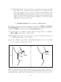
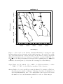
1
User Manual for NetworkDistances 1.0:
Calculating Network-wise Distances
Between Habitat Patches for Spatially
Restricted Species
M.H. Grinnell and J.M.R. Curtis
Fisheries and Oceans Canada
Science Branch, Pacific Region
Pacific Biological Station
3190 Hammond Bay Road
Nanaimo, BC
V9T 6N7
2011
Canadian Technical Report of
Fisheries and Aquatic Sciences 2960
Canadian Technical Report of Fisheries and Aquatic Sciences
Technical reports contain scientific and technical information that contributes to existing knowledge
but which is not normally appropriate for primary literature. Technical reports are directed primarily
toward a worldwide audience and have an international distribution. No restriction is placed on subject
matter and the series reflects the broad interests and policies of Fisheries and Oceans Canada, namely,
fisheries and aquatic sciences.
Technical reports may be cited as full publications. The correct citation appears above the abstract
of each report. Each report is abstracted in the data base Aquatic Sciences and Fisheries Abstracts.
Technical reports are produced regionally but are numbered nationally. Requests for individual
reports will be filled by the issuing establishment listed on the front cover and title page. Out-of-stock
reports will be supplied for a fee by commercial agents.
Numbers 1-456 in this series were issued as Technical Reports of the Fisheries Research Board
of Canada. Numbers 457-714 were issued as Department of the Environment, Fisheries and Marine
Service, Research and Development Directorate Technical Reports. Numbers 715-924 were issued
as Department of Fisheries and Environment, Fisheries and Marine Service Technical Reports. The
current series name was changed with report number 925.
Rapport technique canadien des sciences halieutiques et aquatiques
Les rapports techniques contiennent des renseignements scientifiques et techniques qui constituent
une contribution aux connaissances actuelles, mais qui ne sont pas normalement appropri´es pour la
publication dans un journal scientifique. Les rapports techniques sont destin´es essentiellement `a un
public international et ils sont distribu´es `a cet ´echelon. II n’y a aucune restriction quant au sujet;
de fait, la s´erie refl`ete la vaste gamme des int´erˆets et des politiques de Pˆeches et Oc´eans Canada,
c’est-`a-dire les sciences halieutiques et aquatiques.
Les rapports techniques peuvent ˆetre cit´es comme des publications `a part enti`ere. Le titre exact
figure au-dessus du r´esum´e de chaque rapport. Les rapports techniques sont r´esum´es dans la base de
donn´ees R´esum´es des sciences aquatiques et halieutiques.
Les rapports techniques sont produits `a l’´echelon r´egional, mais num´erot´es `a l’´echelon national. Les
demandes de rapports seront satisfaites par l’´etablissement auteur dont le nom figure sur la couverture
et la page du titre. Les rapports ´epuis´es seront fournis contre r´etribution par les agents commerciaux.
Les num´eros 1 `
a 456 de cette s´erie ont ´et´e publi´es `a titre de Rapports techniques de l’Office des
recherches sur les pˆecheries du Canada. Les num´eros 457 `a 714 sont parus `a titre de Rapports techniques
de la Direction g´en´erale de la recherche et du d´eveloppement, Service des pˆeches et de la mer, minist`ere
de l’Environnement. Les num´eros 715 `
a 924 ont ´et´e publi´es `a titre de Rapports techniques du Service
des pˆeches et de la mer, minist`ere des Pˆeches et de l’Environnement. Le nom actuel de la s´erie a ´et´e
´etabli lors de la parution du num´ero 925.
Canadian Technical Report of
Fisheries and Aquatic Sciences 2960
2011
USER MANUAL FOR NetworkDistances 1.0: CALCULATING NETWORK-WISE
DISTANCES BETWEEN HABITAT PATCHES FOR SPATIALLY RESTRICTED
SPECIES
by
M.H. Grinnell1 and J.M.R. Curtis2
Fisheries and Oceans Canada
Science Branch, Pacific Region
Pacific Biological Station
3190 Hammond Bay Road
Nanaimo, BC
V9T 6N7
1
2
E-mail: [email protected] | tel: (250) 756.7326
E-mail: [email protected] | tel: (250) 756.7157
© Her Majesty the Queen in Right of Canada, 2011
Cat. No. Fs97-6/2960E
Cat. No. Fs97-6/2960E-PDF
ISSN 0706-6457
ISSN 1488-5379
Correct citation for this publication:
Grinnell, M.H. and Curtis, J.M.R. 2011. User manual for NetworkDistances 1.0: Calculating network-wise distances between habitat patches for spatially restricted species.
Can. Tech. Rep. Fish. Aquat. Sci. 2960: iv + 29 p.
ii
CONTENTS
ABSTRACT
iv
´
´
RESUM
E
iv
1 MOTIVATION
1
2 BACKGROUND
2
3 RSD HABITAT AND NETWORK DATA
2
4 METHODOLOGY USING R
4.1 CHALLENGES AND SOLUTIONS TO MEMORY AND TIME REQUIREMENTS . . . . . . . . . . . . . . . . . . . . . . . . . . . . . . .
4.2 OUTLINE OF THE NetworkDistances CODE . . . . . . . . . . . . . .
4
5 INCORPORATING NetworkDistances INTO GRIP2
5.1 DISTANCE UNITS AND CONVERSIONS . . . . . . . . . . . . . . . .
10
12
6 VERIFYING NetworkDistances AND EXTENSIONS
13
7 ACKNOWLEDGEMENTS
13
REFERENCES
14
APPENDIX
17
INDEX
29
iii
5
6
ABSTRACT
Grinnell, M.H. and Curtis, J.M.R. 2011. User manual for NetworkDistances 1.0: Calculating network-wise distances between habitat patches for spatially restricted species.
Can. Tech. Rep. Fish. Aquat. Sci. 2960: iv + 29 p.
We develop an approach to calculate distances along network lines between habitat
patches using NetworkDistances version 1.0. The NetworkDistances code is an
optional extension to the GRIP2 script for species that are restricted to moving along
defined networks (e.g., rivers). For these species, the Euclidean distance may underestimate the actual distance between patches, which may influence patch dynamics. To
more accurately reflect reality, we calculate the shortest ‘along the network’ distance
between connected patches using NetworkDistances, and apply our analysis to a
stream-dwelling minnow, the redside dace (Clinostomus elongatus).
´
´
RESUM
E
Grinnell, M.H. and Curtis, J.M.R. 2011. User manual for NetworkDistances 1.0: Calculating network-wise distances between habitat patches for spatially restricted species.
Can. Tech. Rep. Fish. Aquat. Sci. 2960: iv + 29 p.
Nous avons ´elabor´e une m´ethode de calcul des distances le long des lignes de r´eseaux
entre les parcelles d’habitat au moyen de la version 1.0 de NetworkDistances. Le
code de NetworkDistances est une extension optionnelle du script GRIP2, utilis´e
pour les esp`eces dont les d´eplacements sont limit´es le long de r´eseaux d´efinis (p. ex.
des rivi`eres). Pour ces esp`eces, la distance euclidienne peut sous-estimer la distance
r´eelle entre les parcelles, ce qui peut influer sur la dynamique des parcelles. Pour
refl´eter la r´ealit´e avec plus de justesse, nous calculons la distance la plus courte le
long du r´eseau entre les parcelles reli´ees au moyen de NetworkDistances, puis nous
appliquons notre analyse `a un m´en´e fr´equentant les cours d’eau du r´eseau, soit le m´en´e
long (Clinostomus elongatus).
iv
1
MOTIVATION
A metapopulation consists of multiple spatially discrete populations that occasionally
exchange organisms, even though each population is in a discrete habitat patch. Organisms may move between patches when distances are less than the maximum dispersal distance, and dispersal success is typically inversely related to dispersal distance
(Wolfenbarger 1946; Kitching 1971). The exchange of organisms between patches can
affect patch dynamics and metapopulation persistence via patch recolonization and
extinction rates (Johst et al. 2002). Dispersal rates among patches are typically modeled as a function of distance and cost(s) associated with moving through suboptimal
habitat within a landscape or seascape. For some species, the Euclidean (i.e., straight
line) distance may be appropriate for modeling the migration distance between patches.
However, landscape features may prevent other species from moving in a straight line between patches (Figure 1). For these spatially restricted species, the Euclidean distance
may under-estimate the effective distance between patches, as well as over-estimate
migration rates and dispersal success, leading to biases in predicted patch extinction
and recolonization rates.
network line
habitat patch
Figure 1. Hypothetical landscape for a lotic species that is restricted to moving along
network lines (e.g., rivers) that connect patches of suitable habitat (e.g., riffles). Note
that patch size is proportional to circle size.
2
BACKGROUND
We assume that readers contemplating use of the NetworkDistances code are familiar with the suite of RAMAS software, specifically RAMAS GIS and Metapop
(Ak¸cakaya 2005) as well as GRIP (Curtis and Naujokaitis-Lewis 2008a,b). Briefly, the
GRIP2 script, written in the programming language R (RDCT 2011), is designed for
use with RAMAS GIS 5.0 software to perform systematic global sensitivity analysis
of habitat and population parameters for spatially explicit population viability analyses. The RAMAS GIS programme links spatial data (e.g., habitat suitability maps)
to stochastic metapopulation models, and allows users to evaluate the influence of landscape structure on metapopulation dynamics by manually varying habitat parameters.
The GRIP2 script automates this time-consuming process by generating a specified
number of random sets of spatial and non-spatial parameters, and running these iterations by submitting batch files to RAMAS. By default, GRIP2 and RAMAS
software calculate the Euclidean distance between patches.
We developed NetworkDistances version 1.0, an optional GRIP2 extension, to be
used when organism movement and dispersal is restricted to defined spatial networks
(Figure 2). For example, the movement of lotic fish is restricted to river networks,
while other species may be restricted to moving along hedgerows, coastlines, trails, or
corridors. Specifically, we developed NetworkDistances to automate the calculation
of distances between pairs of patches for redside dace (RSD; Clinostomus elongatus),
an Endangered stream-dwelling minnow found inter alia in four watersheds in the
Greater Toronto Area that discharge into Lake Ontario, Canada (COSEWIC 2007). We
provide some background information on RSD and refer to features of our RSD model
in this manual to illustrate concepts, limitations, and opportunities where appropriate.
Most code within NetworkDistances is generic and could be applied to any spatiallyconstrained species to calculate pairwise distances. We attempt to highlight sections of
code that may require some customization for application with other species.
The NetworkDistances code (NetworkDistances.R) has extensive comments and
should be referenced when reading this document. Please contact the authors if you
have questions, comments, suggestions or concerns regarding the manual, or the code.
We are attempting to keep track of this code’s use; please cite this manual and contact
the authors if you use NetworkDistances. Note that NetworkDistances comes with
absolutely no warranty.
3
RSD HABITAT AND NETWORK DATA
River data were acquired from Natural Resources Canada as a vector line shapefile
(scale = 1 : 50 000; NRC 2011). Georeferenced shapefiles for RSD habitat patches and
rivers were projected in Universal Transverse Mercator (UTM, zone 17), in metres (m)
using the North American 1983 datum. Data preparation for RAMAS input files (e.g.,
habitat mask, habitat suitability grid) was done using the geographic information system programme ArcMap 9.2 (ESRI 2006). Although spatial files for RAMAS input
2
(a)
y←y+1
(b)
Start: set user-specified inputs
and source GRIP2 script
Create replicate habitat map
Inputs: RAMAS output files (.ptc and .asc), and
NetworkDistances input parameters (maxD,
doSnow, cType, nCores, coreName, nZone,
doSpatPlots, and networks)
Run RAMAS GIS Patch
Convert patch maps to UTM
Source NetworkDistances code
Convert network(s) to graph object(s)
Vary metapopulation parameters
Locate patches on graph object(s)
Run RAMAS GIS Metapop
Calculate network-wise distances
among connected patches
no
last iteration?
Combine distances as pairDists
yes
Gather results from each iteration
Output: matrix of network-wise distances,
pairDists; brought into GRIP2 as
Pairwise_Distance
Create NetworkDistances plots
End of file GRIP2
Figure 2. Simplified flow diagram of the GRIP2 script (a), and the optional NetworkDistances code (b). The NetworkDistances algorithm is expanded in Subsection 4.2, and inputs are described in Section 5.
(e.g., *.asc) must have, inter alia, consistent precision and spatial extent (Ak¸cakaya
2005), networks may extend beyond the grid’s perimeter. However, larger networks
may increase memory and processing time, as discussed in Subsection 4.1.
In our case study, we modeled the metapopulation dynamics of RSD within a small
study area, which contains two watersheds (Figure 3). Two RSD characteristics enabled
us to simplify our analysis, and thus our code. First, genetic analyses indicate that RSD
do not move between watersheds (M. Poos, unpublished data), which allowed us to
divide the study area into two independent watersheds, which we refer to as networks.
We defined individual networks by their Strahler stream order number, a measure of
branching complexity (Strahler 1957). Second, mark-recapture studies indicate that
RSD dispersal is independent of stream direction (Poos and Jackson, in press), which
allowed us to create undirected graph objects. The benefits of these two simplifications
are explained in later sections.
3
UTM northing (km)
4875
N
4870
2HC11
2HC10
4865
2HC12
2HC09
4860
4855
Study area
Lake Ontario
4850
630
640
650
660
UTM easting (km)
Figure 3. Two of the four watersheds (e.g., 2HC11) run through the redside dace
study area, and discharge into Lake Ontario (NRC 2011). Geographic coordinates are
projected in Universal Transverse Mercator (UTM, zone 17), in kilometres (km). Note
that networks are different colours to aid with differentiation.
4
METHODOLOGY USING R
We assume the user has at least a working ability with the R statistical and graphing
programme (RDCT 2011), and is familiar with spatial data. In addition to the R packages required for GRIP2 [sp (Pebesma and Bivand 2005; Bivand et al. 2008), rgdal
(Keitt et al. 2010), spatial (Venables and Ripley 2002), spatstat (Baddeley and
Turner 2005), adehabitat (Calenge 2006), maptools (Lewin-Koh and Bivand 2011),
ade4 (Dray and Dufour 2007), and gpclib (Peng 2010)], NetworkDistances requires
at least five additional packages: PBSmapping (Schnute et al. 2010) to handle georeferenced data; graph (Gentleman et al. 2010), RBGL (Carey et al. 2010), and igraph
(Cs´ardi and Nepusz 2006) to handle graph objects; as well as gtools (Warnes 2010)
to sort strings with embedded numbers. One or two other packages are optional: snow
(Tierney et al. 2008) to use multiple processors; and (also optionally) Rmpi (Yu 2010)
to use “MPI” type clusters on non-Windows machines. Non-Windows machines require
additional code to ensure that files are compatible with both dos and unix, as well as
the WineHQ programme (WPD 2010) to run RAMAS if NetworkDistances is
used along with GRIP2.
4
4.1
CHALLENGES AND SOLUTIONS TO MEMORY AND TIME
REQUIREMENTS
The main challenge to NetworkDistances is that large, complex networks with many
patches and high resolution maps may be costly in terms of required memory and processing time. However, memory and time requirements can be reduced significantly using four strategies: (1) splitting large networks into independent sub-networks; (2) loading saved RData objects from the first iteration; (3) parallel processing; and (4) reducing
map resolution.
First, large networks will require less memory and processing time if they can be split
into independent sub-networks in a biologically meaningful way. Splitting a large network (within which some patches are not connected) into multiple sub-networks (within
which all patches are connected) reduces the number of pairwise distance calculations.
For example, because RSD do not migrate between watersheds, we split the large river
network in our study area into two small independent networks by watershed boundaries (Figure 3). More generally, consider a hypothetical scenario with three patches on
one network (e.g., patches a, b, c), and three patches on a second, independent network
(e.g., d, e, f ). Treated as one large network, there are 15 pairwise distances to calculate
for the upper triangle of the required 6 × 6 matrix:
a
b
c
d
e
f
a
b
c
d
e
f
0
1
2 NA NA NA
1
0
3 NA NA NA
2
3
0 NA NA NA
NA NA NA 0
4
5
NA NA NA 4
0
6
NA NA NA 5
6
0
(1)
where “NA” indicates that the distance cannot be calculated because the two patches
are unconnected (i.e., due to migration barriers between patches).3 Note that the
lower triangle is the transpose of the upper triangle because dispersal is assumed to
be independent of direction. Alternately, treating the two sub-networks independently
reduces the number of pairwise distance calculations from 15 to 6, all of which can be
calculated:
a
a 0
b 1
c 2
b
1
0
3
c
d
2
d 0
and
3
e 4
0
f 5
e
4
0
6
f
5
6
0
(2)
To further reduce network sizes, we then removed sections outside the study area boundary.
3
The algorithm requires more time and memory to attempt to calculate distances between unconnected patches than connected patches, and eventually sets these distances to NA.
5
Second, as a sensitivity analysis programme, GRIP2 typically runs multiple iterations, and network lines remain constant from one iteration to another. Thus, networks
can be saved to disk as RData objects on the first iteration, and loaded from disk on
subsequent iterations. This strategy reduces processing time considerably for large networks. However, due to changing patch locations associated with random changes in
landscape structure each iteration, pairwise distances must be calculated iteratively.
Third, calculating pairwise distances can be computationally demanding, and takes
considerable time when networks are large, or when there are many patches. In these
cases, calculating pairwise distances requires more processing time than creating networks, and multiple processors can be used to reduce processing time. In this case,
the NetworkDistances code starts multiple instances of R, and divides pairwise distance calculations among processors on the cluster. With sufficient memory, parallel
processing may even reduce processing time on computers with only one processor.
Finally, time and memory requirements increase in proportion to increasing network
size, branching complexity, number of pairwise distance calculations, and size of input
maps. Processing time and memory requirements were considerable because the RSD
study area was modeled at a fine spatial resolution: our input maps have approximately
443 000 15 m × 15 m grid cells. For example, between 1.0 and 1.5 hours were required to
run 50 GRIP2 iterations of the RSD study area on two different machines. Of the total
required time, between 2.8 and 5.2% was used to run the NetworkDistances code.
Our analysis required fine spatial resolution because RSD are typically distributed in
headwater streams that are closely spaced, but networks for other species may not
require such fine spatial resolution.
4.2
OUTLINE OF THE NetworkDistances CODE
Our analysis relies on well-developed methods from graph theory to measure distances
between patches along networks. Although graph theory has been around for many
years, using graphs to model node (e.g., patch) connectivity is relatively new to the
field of conservation biology (Urban et al. 2009). We developed the NetworkDistances
code in the programming language R to facilitate implementation with GRIP2, and
to cope with changing patch locations each iteration.
The NetworkDistances code is typically sourced via the GRIP2 script for spatially restricted species, and we assume that the user is familiar with GRIP2. Alternately, NetworkDistances can be run independently if all the required inputs
are specified appropriately (e.g., arguments for the function GridToUTM( ptc, asc )
and Section 5). The following algorithm outlines the NetworkDistances procedure
and explains the code’s major functions; we recommend that users follow along in the
NetworkDistances.R code (Listing 1, Appendix).
This algorithm is run for each y replicate iteration in newNreps as follows:
1. Convert RAMAS spatial output for patches from grid locations to UTM (m).
GridToUTM( ptc, asc ) Retrieve spatial data for each patch from RA6
MAS output files: ptcfile (i.e., ptc y.ptc); and OrigPatchmap (i.e.,
spp PA.asc), where spp is typically the species name. The ptcfile file
indicates patch centers relative to the upper-left corner of the grid (in km),
while OrigPatchmap georeferences the lower-left corner of the grid (m).4
Patch locations are converted to UTM (m) using the geographic information
in the OrigPatchmap file header. The arguments ptc and asc reference the
ptcfile and OrigPatchmap files, respectively. The function returns a list
with two elements: the location of patches in UTM (m), patchesUTM, as an
EventData object; and the grid outer extent in UTM (m), gridExtent.
2. Step 2 is done once if there is only one network, or iteratively if there are multiple
sub-networks. First, import the network shapefiles in UTM (m) as a PolySet
object, netVect, which indicates node locations (X, Y), and node connectivity.
Set patchesUTM to patches; this is required because patches will be subset
during the following calculations to include only the patches within the current
network. Each time the loop is iterated, patchesUTM is re-set to patches, which
ensures that all of the patches are considered.
(a) If available, load the saved netVect.RData object, and skip to Step 2b.
Otherwise, proceed as follows:
CreateUniqueID( dat ) Create a unique ID number for each unique node
(X, Y) to ensure the graph object is continuous. By default, shapefiles have a different ID for each node, which can cause problems for
nodes that are common to two lines that merge into a single stem (e.g.,
river confluence). These two nodes, which have identical (X, Y) location, must have identical IDs for the graph object to consider them
attached. The argument dat is the network object, and the function
returns the updated network object, netVect with new columns (especially, UniqueID).
GetToFromDist( dat ) Create a matrix indicating the unique ID for each
segment’s start (e.g., from) and end (e.g., to) nodes, as well as the Euclidean distance along each edge. For these short edges, the Euclidean
distance sufficiently approximates reality if maps have a fine spatial resolution. Nodes correspond to network vertices, and edges correspond to
lines between vertices. Note that the words to and from simply indicate endpoints because the graph object is undirected, meaning that the
4
Pairwise distances among patches can be calculated from one edge to the other, from the edge of
one patch to the center of the other, or from center to center. The center-to-center distance may be
very different from the edge-to-edge distance when patches are large (i.e., patch edges extend away
from the patch center along network lines). For simplicity, we assume that the distance between patch
centers best describes pairwise distances. Thus, network-wise distances are calculated from center-tocenter; set distance <- ‘‘Default: Center to center’’ in GRIP2 prior to running iterations
to ensure that the ptfile file refers to patch centers.
7
distance from Pop 1 to Pop 2 is equal to the distance from Pop 2 to
Pop 1. Species that require a directed graph (i.e., dispersal depends on
direction) will require the user to modify this function. The argument
dat is the network object, and the function returns toFromDist (later
renamed tfTable), a matrix of node IDs, node locations, and distances
between nodes (i.e., edge weights).
Save the output (e.g., network object, netVect, and to-from matrix,
tfTable) as a netVect.RData object to be used in subsequent iterations.
(b) Load the saved netVect.RData object, then:
EnsureUniqueSites( dat ) Ensure that each patch has a unique ID so
that pairwise distances are calculated for each patch. Duplicate names
are made unique by appending letters (e.g., “a”) to the second duplicate,
and so on.5 The argument dat is the patches, and the function updates
the column Site with new IDs if duplicates exist.
SnapToNodes( pops ) Snap each patch to the nearest network node. Basically, identify the closest node to the patch center, and change the node
ID to the patch ID (Figure 4). Thus, patch locations are shifted, but are
likely within tolerance considering that RAMAS uses a grid to define
patches. The search radius is controlled by the parameter maxD, which
restricts candidate nodes to those within maxD units of the patch. It is
important to note that patches that are more than maxD from all nodes
are omitted from the analysis. Although a habitat mask will ensure that
patches are located near network lines, distances between patch centers
and network nodes can be large when network lines are straight (i.e.,
fewer nodes), or when patches are large. An iterative search reduces
units of the patch; if
processing time: first search for nodes within maxD
4
there are no nodes, search again within maxD units. The argument pops
is set to the patch. The function returns minDists, which indicates
the distance from each patch to the nearest node (or NA if there are no
nodes), and the function updates the node ID in tfTable (for both to
and from nodes).
ftM2graphNEL( ft, edgemode, W ) This function is from the graph package, and creates an object of class graph to represent the network.
Prior to calling this function, duplicate rows must be omitted from
the tfTable object. The argument ft is the to-from table, tfTable,
edgemode indicates that the graph is not directed, and W indicates the
edge weights. The function returns the graph object, netGraph.
CalcDistMatrix( dat ) Calculate the shortest (e.g., least-cost) networkwise distances (m) between each pair of patches in the network using Dijkstra’s (1959) algorithm, implemented by the function sp.between( ).
5
Although patches will have unique IDs if NetworkDistances is sourced via GRIP2, there may
be duplicate patch IDs if NetworkDistances is run independently.
8
This function can use parallel processing to decrease processing time, if
doSnow is TRUE (Section 5). Note that the distance from the patch
to the network, minDists, is not included in the pairwise distance
calculation because the patch is technically on the network, even if
the patch’s center is shifted slightly. The argument dat is the graph
object, and the function returns distMat, a matrix of pairwise distances with row and column names corresponding to patch names. The
distMat object is saved as a distMat.netVect.RData object in the
folder RDataOutTemp/ so that distances between points in independent
sub-networks can be brought together as one large distance matrix using
CombineDistances( dat ) in Step 3.
3. Combine the pairwise distance matrices from each independent sub-network into
one large matrix.
RemoveDupPatches( mat ) Ensure that each patch is only in one network, and
ignore networks that do not contain any patches. This function ensures
that each patch is snapped to the network with the single closest node. For
example, large maxD values can cause patches to be inadvertently snapped to
two networks if patches are located within maxD of nodes on both networks.
The argument mat is the matrix of minDists, named minDistMat, which has
a column for each network, and a row for each patch. The function returns
patchNetwork, with a column for each network that contains patches, and a
row for each patch that has been snapped to a network (patches are assumed
to belong in the network with the nearest node).
CombineDistances( dat ) Combine distance matrices from each sub-network
into one large pairwise distance matrix. The argument dat is the set of
network name(s) that contain patches, and the function returns the matrix of pairwise distances for the entire group of networks, pairDists. The
distance between points in different independent sub-networks (i.e., unconnected patches) is NA.
FillPairDists( mat ) Ensure that pairDists has one column and one row for
each patch, even if the patch was omitted from the analysis. The argument
mat is pairDists, and the function returns an updated pairDists.
The pairDists matrix is ordered by row and column names for compatibility
with GRIP2 requirements. The matrix is saved as pairDists.y.RData in the
folder RDataOutDist/ to be retrieved by GRIP2 for further analysis.
4. Step 4 is done after GRIP2 has run to completion, and generates figures of
networks and patches. These plots can take considerable time to create when
there are many large networks and many iterations; skip this step to speed up
the analysis (Section 5).
9
PlotNetworkPatches( ) Plot georeferenced network(s) and patches in UTM
(m). There are no arguments, and the function does not return anything;
instead, the function creates a portable document format (PDF) file in the
folder RDataOutDist/ named plot.pdf, with one page for each iteration
(Figure 5). Patch names in green have been snapped to network lines; patch
names in red have been omitted from the analysis (i.e., patches more than
maxD units from all network nodes).
5
INCORPORATING NetworkDistances INTO GRIP2
In addition to the usual controls and parameters required for GRIP2 and RAMAS,
NetworkDistances requires several additional user-specified inputs which must be
specified in GRIP2 or at the start of the NetworkDistances code:
calc network dist Set to TRUE to calculate distances along networks; set to FALSE to
calculate Euclidean distances. Value: logical.
maxD Maximum distance (m) from each patch to search for candidate network nodes
in SnapToNodes( pops ). Value: number.
doSnow Set to TRUE to use parallel processing in CalcDistMatrix( dat ); set to FALSE
for no parallel processing. Value: logical.
(a)
(b)
habitat patch
moved to
nearest node
habitat
patch
maxD
network
search
radius
node
Figure 4. Hypothetical network and habitat patch (a). The network is composed of
nodes connected by segments. Three nodes are within maxD units of the patch’s center;
the SnapToNodes( pops ) function shifts the patch’s location to the nearest node (b).
10
newNreps = 4
●
4862000
Pop 1
●
Pop 2
●
Pop 4
●
4858000
2HC11_C5
●
Pop 5
●
2HC12_C5
Pop 7
●
Pop 6
4856000
UTM northing (m)
4860000
Pop 3
●
4854000
Pop 8
660000
662000
664000
666000
668000
UTM easting (m)
Figure 5. Plot created by the function PlotNetworkPatches( ) showing the eight
habitat patches and two networks on the fourth iteration of the redside dace study
area. Note that patches Pop 4, Pop 6, and Pop 8 are all connected, and are on network
2HC12 C5; these patches are not connected to the patches on network 2HC11 C5 (e.g.,
Pop 1). Note also that patch names are shown in black for printing purposes, but would
normally be shown in green (i.e., they have all been snapped to network lines).
cType Cluster type (if doSnow). Use ‘‘SOCK’’ for Windows machines, or either
‘‘SOCK’’ or ‘‘MPI’’ for non-Windows machines. Value: character.
nCores Number of cores for parallel processing (if doSnow). For example, in Windows,
this indicates the number of instances of Rscript.exe that are initialized and
used in CalcDistMatrix( dat ). Note that nCores controls a trade-off between
the number of cores, and the memory available to each core. Value: integer.
11
coreName Processor name (if doSnow). Value: character (e.g., ‘‘localhost’’).
nZone UTM zone, required to align patches and network lines. Value: integer.
doSpatPlots Set to TRUE to call PlotNetworkPatches( ) and generate figures showing
patches and networks for each iteration; set to FALSE to skip this step. Value:
logical.
networks Shapefile network name(s), not including extension(s). If there are multiple shapefiles (i.e., the network is broken up into independent sub-networks),
networks is a concatenation of each sub-network name; if there is only one network, networks is the network name. Input shapefiles (in UTM, m) must be
in the folder NetworkShapefiles/. Value: character vector (e.g., c(‘‘2HC09’’,
‘‘2HC10’’) for multiple sub-networks; character (e.g., ‘‘2All’’) for one network).
The NetworkDistances code should be in the same folder as GRIP2, the working directory. Create two folders in the working directory: NetworkShapefiles/, and
SavedNetworkObjects/. The folder NetworkShapefiles/ contains the shapefiles for
the network(s). The folder SavedNetworkObjects/ may contain saved netVect.RData
objects from previous iterations to speed up computations, if they are available (Subsection 4.2, Step 2a).
Two additional folders are created during the simulation: RDataOutTemp/, and
RDataOutDist/. The folder RDataOutTemp/ holds temporary R output each iteration. The folder RDataOutDist/ contains pairwise distance matrices for each iteration
and network. Pairwise distance objects are named pairDists.y.RData in order to
be retrieved later by GRIP2 to calculate various statistics. Two other objects are
saved in the folder RDataOutDist/ under the names patchNetworkDist.y.RData (contains minDistMat and patchNetwork), and patches.y.RData (contains patches and
patchesUTM). This folder may also contain the figure of patches and network lines,
plot.pdf.
5.1
DISTANCE UNITS AND CONVERSIONS
Distance units may vary between the RAMAS programme, the GRIP2 script, and
the NetworkDistances code. For consistency, the NetworkDistances code uses metres (converting kilometres to metres when necessary). For the RSD analysis, network
shapefiles are in metres, and RAMAS output files are in metres (e.g., Patchmap) and
kilometres (e.g., ptcfile). NetworkDistances calculations and inputs (e.g., maxD)
are in metres. However, because RAMAS input files require distances in kilometres, pairDists is converted from metres to kilometres just prior to being returned to
GRIP2 as a matrix of pairwise distances, Pairwise Distance. It is critical that users
ensure that distances have expected units in RAMAS, GRIP2, and NetworkDistances input and output files.
12
6
VERIFYING NetworkDistances AND EXTENSIONS
Distances calculated using the NetworkDistances code should sufficiently approximate
reality if network shapefiles are accurate and of sufficient spatial resolution. However,
we recommend that users confirm the accuracy of the NetworkDistances output by
checking various statistics, the distance matrix pairDists, and the figure generated
by the function PlotNetworkPatches( ). Additionally, ensure that RAMAS output
files (i.e., spp.asc) line up with networks by plotting patches and network lines, as well
as verifying the patch map grid location (Subsection 4.2, Step 1). Ensure that maxD
is sufficiently large to locate candidate nodes in SnapToNodes( pops ). Investigate
the matrices in patchNetworkDist.y.RData to ensure that patches are assigned to
the correct network. These matrices will also indicate whether maxD is too small (e.g.,
patches are omitted), or too large (e.g., snapped distances are much shorter than maxD).
Also, ensure that RAMAS files, grids, and network lines have identical projections and
correct units.
As previously mentioned, one extension is to use directed graphs; for example, migration distance may depend on direction for fish that inhabit fast-flowing rivers (Step
2a). A second use of directed graphs is to model the effects of patch size (e.g., area)
and population on migration; for example, large patches may have more immigrants,
while large populations may have more emigrants. Another extension is to incorporate
a changing spatial network over time. For example, a previously continuous river network could become fragmented by dams. This type of temporal change would increase
processing time because year-specific network objects would have to be calculated each
year.
7
ACKNOWLEDGEMENTS
The authors thank K. Kinnersley for facilitating our use of the high performance computing facility at the Institute of Ocean Sciences, I. Naujokaitis-Lewis for technical
support, and M. Poos for comments which improved the document. Funding support
was provided by Fisheries and Oceans Canada’s National Species at Risk Programme.
13
REFERENCES
Ak¸cakaya, H. R. 2005. RAMAS GIS: Linking spatial data with population viability
analysis. Applied Biomathematics. URL www.ramas.com/ramas.htm#gis. User
manual for version 5
Baddeley, A. and Turner, R. 2005. Spatstat: An R package for analyzing spatial point
patterns. Journal of Statistical Software 12(6): 1–42. URL www.jstatsoft.org. R
package version 1.21-6
Bivand, R. S., Pebesma, E. J. and G´omez-Rubio, V. 2008. Applied spatial data analysis
with R. Springer, NY. URL http://www.asdar-book.org/. R package version 0.980
Calenge, C. 2006. The package “adehabitat” for the R software: A tool for the analysis
of space and habitat use by animals. Ecological Modelling 197: 516–519. doi:10.
1016/j.ecolmodel.2006.03.017. R package version 1.8-4
Carey, V., Long, L. and Gentleman, R. 2010. RBGL: An interface to the BOOST graph
library. URL http://CRAN.R-project.org/package=RBGL. R package version 1.26.0
COSEWIC (Committee on the Status of Endangered Wildlife in Canada). 2007.
COSEWIC assessment and update status report on the redside dace Clinosomus
elongatus in Canada. Technical Report, Canadian Wildlife Service and Environment
Canada. URL www.sararegistry.gc.ca/status
Cs´ardi, G. and Nepusz, T. 2006. The igraph software package for complex network
research. InterJournal Complex Systems: 1695. URL http://igraph.sf.net. R
package version 0.5.5-2
Curtis, J. M. R. and Naujokaitis-Lewis, I. R. 2008a. Sensitivity of population viability
analysis to spatial and nonspatial parameters using GRIP. Ecological Applications
18(4): 1002–1013. doi:10.1111/j.1523-1739.2008.01066.x
Curtis, J. M. R. and Naujokaitis-Lewis, I. R. 2008b. Source code for the program
GRIP 1.0 (Generation of Random Input Parameters). URL http://esapubs.org/
archive/appl/A018/033/suppl-1.htm. Ecological Archives: A018-033-S1 (Supplement)
Dijkstra, E. W. 1959. A note on two problems in connexion with graphs. Numerische
Mathematik 1(1): 269–271. doi:10.1007/BF01386390
Dray, S. and Dufour, A. B. 2007. The ade4 package: Implementing the duality diagram
for ecologists. Journal of Statistical Software 22(4): 1–20. URL http://CRAN.
R-project.org/package=ade4. R package version 1.4-17
14
ESRI (Environmental Systems Research Institute). 2006. ArcMap for ArcGIS Desktop.
URL http://www.esri.com. Version 9.2, Build 1324, ArcView License
Gentleman, R., Whalen, E., Huber, W. and Falcon, S. 2010. graph: A package to
handle graph data structures. URL http://CRAN.R-project.org/package=graph.
R package version 1.28.0
Johst, K., Brandl, R. and Eber, S. 2002. Metapopulation persistence in dynamic
landscapes: The role of dispersal distance. Oikos 98(2): 263–270. doi:10.1034/j.
1600-0706.2002.980208.x
Keitt, T. H., Bivand, R., Pebesma, E. and Rowlingson, B. 2010. rgdal: Bindings for the
geospatial data abstraction library. URL http://CRAN.R-project.org/package=
rgdal. R package version 0.6-33
Kitching, R. 1971. A simple simulation model of dispersal of animals among units of
discrete habitats. Oecologia 7(2): 95–116. doi:10.1007/BF00346353
Lewin-Koh, N. J. and Bivand, R. 2011. maptools: Tools for reading and handling
spatial objects. URL http://CRAN.R-project.org/package=maptools. With contributions from E. J. Pebesma, E. Archer, A. Baddeley, H.-J. Bibiko, S. Dray, D.
Forrest, M. Friendly, P. Giraudoux, D. Golicher, V. G. Rubio, P. Hausmann, K. O.
Hufthammer, T. Jagger, S. P. Luque, D. MacQueen, A. Niccolai, T. Short, B. Stabler
and R. Turner. R package version 0.8-6
NRC (Natural Resources Canada). 2011. GeoGratis: Geospatial data available online
at no cost and without restrictions. URL http://geogratis.gc.ca. Retrieved 5
January 2011
Pebesma, E. J. and Bivand, R. S. 2005. Classes and methods for spatial data in R.
R News 5(2): 9–13. URL http://cran.r-project.org/doc/Rnews/. R package
version 0.9-80
Peng, R. D. 2010. gpclib: General polygon clipping library for R. URL http://
CRAN.R-project.org/package=gpclib. With contributions from D. Murdoch and
B. Rowlingson; GPC library by A. Murta. R package version 1.5-1
Poos, M. S. and Jackson, D. A. (in press). Incorporating species specific data into
patch occupancy models: Impact of dispersal on estimates of viability of stream
metapopulations. Landscape Ecology doi:10.1007/s10980-011-9683-2
RDCT (R Development Core Team). 2011. R: A language and environment for statistical computing. URL www.R-project.org. R Foundation for Statistical Computing.
Vienna, Austria. R version 2.13.0
15
Schnute, J. T., Boers, N., Haigh, R. and Couture-Beil, A. 2010. PBSmapping: Mapping fisheries data and spatial analysis tools. URL http://CRAN.R-project.org/
package=PBSmapping. R package version 2.61.9
Strahler, A. N. 1957. Quantitative analysis of watershed geomorphology. Transactions
of the American Geophysical Union 8(6): 913–920
Tierney, L., Rossini, A. J., Li, N. and Sevcikova, H. 2008. snow: Simple network of
workstations. URL http://CRAN.R-project.org/package=snow. R package version
0.3-3
Urban, D. L., Minor, E. S., Treml, E. A. and Schick, R. S. 2009. Graph models of habitat
mosaics. Ecology Letters 12(3): 260–273. doi:10.1111/j.1461-0248.2008.01271.x
Venables, W. N. and Ripley, B. D. 2002. Modern applied statistics with S. Springer,
New York, fourth ed. URL http://www.stats.ox.ac.uk/pub/MASS4. ISBN 0-38795457-0. R package version 7.3.3
Warnes, G. R. 2010. gtools: Various R programming tools. URL http://CRAN.
R-project.org/package=gtools. Includes R source code and/or documentation
contributed by B. Bolker and T. Lumley. R package version 2.6.2.
Wolfenbarger, D. O. 1946. Dispersion of small organisms: Distance dispersion rates of
bacteria, spores, seeds, pollen, and insects; Incidence rates of diseases and injuries.
American Midland Naturalist 35(1): 1–152
WPD (Wine Project Developers). 2010. WineHQ: Wine is not an emulator. URL
www.winehq.org. Version 1.2.2
Yu, H. 2010. Rmpi: Interface (wrapper) to MPI (Message-Passing Interface). URL
http://CRAN.R-project.org/package=Rmpi. R package version 0.5-9
16
APPENDIX
Electronic copies of the modified GRIP2 script for use with NetworkDistances,
the NetworkDistances.R code (Listing 1), and the RSD study area data (e.g., river
networks, RSD habitat map) are available free from the authors.
Listing 1. The NetworkDistances code (NetworkDistances.R version 1.0) is written
in the programming language R (RDCT 2011).
1 # ##############################################################################
#
3 # Author :
Matthew H . G r i n n e l l
# Affiliation :
Pacific B i o l o g i c a l Station , F i s h e r i e s and Oceans Canada
5 # Research group : C o n s e r v a t i o n Biology Section ( Janelle M . R . Curtis )
# Contact :
e - mail : matt . grinnell@dfo - mpo . gc . ca | tel : ( 2 5 0 ) 7 5 6 . 7 3 2 6
7 #
e - mail : janelle . curtis@dfo - mpo . gc . ca | tel : ( 2 5 0 ) 7 5 6 . 7 1 5 7
# Project :
GRIP2 e x t e n s i o n for m o v e m e n t between patches within n e t w o r k s
9 # Code name :
NetworkDistances .R
# Code version :
1.0
11 # Date started :
2010 -11 -30
# Date modified : 2011 -11 -16
13 #
# Goal : Convert spatial lines ( i . e . , n e t w o r k s ) and points ( i . e . , patches ) to a
15 # graph object , and c a l c u l a t e network - wise d i s t a n c e s between each pair of
# habitat patches . Output a matrix of p a i r w i s e distances , pairDists , which
17 # is also saved as a . RData object in the folder R D a t a O u t D i s t . These objects
# are indexed by i t e r a t i o n number y in n e w N r e p s ( e . g . , p a i r D i s t s .1. RData ).
19 #
# R e q u i r e m e n t s : This code is d e s i g n e d for use with GRIP [1] , and RAMAS GIS
21 # 5.0[2]; however , the code could be m o d i f i e d for stand - alone use . R e g a r d l e s s
# of whether N e t w o r k D i s t a n c e s is used alone or with GRIP2 , read the
23 # N e t w o r k D i s t a n c e s user manual [3] for a d d i t i o n a l details .
#
25 # Notes : Please contact the authors if you have suggestions , comments , or
# concerns . Additionally , we are a t t e m p t i n g to keep track of this code ' s use ;
27 # please contact the authors if the code was useful for r e s e a r c h . We r e c o m m e n d
# that users verify their output by c h e c k i n g various s t a t i s t i c s and graphs . We
29 # assume that the user has a working ability with R [4] , and is f a m i l i a r with
# spatial data . It is crucial that users verify that d i s t a n c e s are in the
31 # correct units t h r o u g h o u t this script ! This code comes with a b s o l u t e l y no
# warranty .
33 #
# References :
35 # [1] Curtis , J . M . R . and Naujokaitis - Lewis , I . R . 2008. Source code for the
#
program GRIP 1.0 ( G e n e r a t i o n of Random Input P a r a m e t e r s ).
37 #
URL http : / / esapubs . org / archive / appl / A018 / 033 / suppl -1. htm . E c o l o g i c a l
#
Archives : A018 -033 - S1 ( S u p p l e m e n t )
39 # [2] Akcakaya , H . R . 2005. RAMAS GIS : Linking spatial data with p o p u l a t i o n
#
v i a b i l i t y analysis . Applied B i o m a t h e m a t i c s . URL www . ramas . com . User
41 #
manual for version 5
# [3] Grinnell , M . H . and Curtis , J . M . R . 2011. User manual for
43 #
N e t w o r k D i s t a n c e s 1.0: C a l c u l a t i n g network - wise d i s t a n c e s between habitat
#
patches for s p a t i a l l y r e s t r i c t e d species . Can . Tech . Rep . Fish . Aquat .
45 #
Sci . 2960: iv + 29 p .
# [4] RDCT ( R D e v e l o p m e n t Core Team ). 2011. R : A l a n g u a g e and e n v i r o n m e n t for
47 #
s t a t i s t i c a l c o m p u t i n g . URL www .R - project . org . R f o u n d a t i o n for
#
S t a t i s t i c a l C o m p u t i n g . Vienna , Austria . R version 2.13.0
49 #
# ##############################################################################
51
# ##########################################
53 # #### Start file ' N e t w o r k D i s t a n c e s .R ' #####
# ##########################################
17
55
# Ensure that all the required user - s p e c i f i e d inputs are present . Note : if
57 # N e t w o r k D i s t a n c e s is not called from GRIP2 , these p a r a m e t e r values need to be
# i n i t i a l i z e d prior to here . Also , ensure the proper file s t r u c t u r e has been
59 # created , the required habitat patch i n f o r m a t i o n is a v a i l a b l e ( i . e . , the ptc
# and asc a r g u m e n t s to the fun c t i o n G r i d T o U T M ) , and define y .
61 if ( ! all ( exists ( x = c ( " maxD " , " doSnow " , " cType " , " nCores " , " coreName " , " nZone " ,
" doSpatPlots " , " networks " ))) ) {
63
# Stop e v e r y t h i n g
stop ( " Missing required user - specified inputs for ' N e t w o r k D i s t a n c es .R ' " )
65 } # End ensure user - inputs
67 # Create a t e m p o r a r y d i r e c t o r y to hold output each i t e r a t i o n
if ( " RDataOutTemp " % in % list . files ( ) ) {
69
# Delete the old d i r e c t o r y
unlink ( x = " RDataOutTemp " , recursive = TRUE )
71
# Create a new d i r e c t o r y
dir . create ( path = " RDataOutTemp " )
73
# End if d i r e c t o r y exists , o t h e r w i s e
} else {
75
# Make a new d i r e c t o r y
dir . create ( path = " RDataOutTemp " )
77 } # End if the d i r e c t o r y does not exist
79 # Get habitat patch l o c a t i o n s ( r e f e r e n c e d via the grid ) from the . ptc file , and
# grid g e o r e f e r e n c e info from the . asc file ( to g e o r e f e r e n c e the patches ).
81 # Convert to UTM and return habitat patches : p a t c h e s U T M . Note that users * must *
# verify that this function s p e c i f i e s d i s t a n c e units c o r r e c t l y : as is , this
83 # function expects d i s t a n c e s in m ( asc ) and km ( ptc ) , and c o n v e r t s to m .
GridToUTM <- function ( ptc , asc ) {
85
# Get the first item from the first nmax lines in the ptc file
firstItemPTC <- scan ( file = ptc , skip =0 , sep = " ," , what = " character " ,
87
quiet = TRUE , flush = TRUE , blank . lines . skip = FALSE , nmax =200 )
# Get line info for the habitat patch data ( usually line 58)
89
linePatchPTC <- grep ( pattern = paste ( Npops , " populations " , sep = " " ) ,
x = firstItemPTC , perl = TRUE )[1]
91
# If l i n e P a t c h P T C is NA ( pos s i b l y due to not enough lines ) , search again
if ( is . na ( linePatchPTC ) ) {
93
# Get the first item from all the lines in the ptc file : this can take
# a long time
95
firstItemPTC <- scan ( file = ptc , skip =0 , sep = " ," , what = " character " ,
quiet = TRUE , flush = TRUE , blank . lines . skip = FALSE )
97
# Get line info for the habitat patch data
linePatchPTC <- grep ( pattern = paste ( Npops , " populations " , sep = " " ) ,
99
x = firstItemPTC , perl = TRUE )[1]
# Print a warning
101
warning ( " Increase ' nmax ' in firstItemPTC () to avoid scanning whole file " )
} # End if l i n e P a t c h P T C is NA
103
# If l i n e P a t c h P T C is * still * NA , error
if ( is . na ( linePatchPTC ) ) {
105
# Error message
stop ( " Check file ' " , ptc , " ' : unable to find patch info " )
107
} # End if l i n e P a t c h P T C is * still * NA
# Scan to get patch info into a list : Site , X , and Y ( in km , r e f e r e n c e d via
109
# the grid )
patchData <- scan ( file = ptc , skip = linePatchPTC , nlines = Npops , sep = " ," ,
111
what = list ( Site = " " , X =0 , Y =0) , quiet = TRUE , flush = TRUE )
# Get the first item from the first nmax lines in the ( s o m e t i m e s large ) . asc
113
# file . This * should * contain the r e q u i r e d lines , since they are usually at
# the top of the . asc file ( as a header ).
115
firstItemASC <- scan ( file = asc , skip =0 , sep = " \ t " , what = " character " ,
quiet = TRUE , flush = TRUE , blank . lines . skip = FALSE , nmax =10 )
117
# Get the line info for the X l o c a t i o n
lineXASC <- grep ( pattern = " xllcorner " , x = firstItemASC , perl = TRUE )[1]
119
# If lineXASC is NA ( possibl y due to not enough lines ) , search again
18
121
123
125
127
129
131
133
135
137
139
141
143
145
147
149
151
153
155
157
159
161
163
165
167
169
171
173
175
177
179
181
183
if ( is . na ( lineXASC ) ) {
# Get the first item from all lines in the asc file -- this can take
# much longer !
firstItemASC <- scan ( file = asc , skip =0 , sep = " \ t " , what = " character " ,
quiet = TRUE , flush = TRUE , blank . lines . skip = FALSE )
# Get the line info for the X l o c a t i o n
lineXASC <- grep ( pattern = " xllcorner " , x = firstItemASC , perl = TRUE )[1]
# Print a warning
warning ( " Increase ' nmax ' in firstItemASC () to avoid scanning whole file " )
} # End if lineXASC is NA
# If lineXASC is * still * NA , error
if ( is . na ( lineXASC ) ) {
# Error message
stop ( " Check file ' " , asc , " ' : unable to georeference the grid " )
} # End if lineX ASC is * still * NA
# G e o r e f e r e n c e the grid ' s lo c a t i o n : get the left side ' X ' l o c a t i o n ( UTM , m )
ASCgridLLX <- as . numeric ( scan ( file = asc , skip = lineXASC - 1 , sep = " \ t " ,
what = list ( NULL , " numeric " ) , quiet = TRUE , flush = TRUE , nlines =1)[[2]] )
# Get the line info for the Y l o c a t i o n
lineYASC <- grep ( pattern = " yllcorner " , x = firstItemASC , perl = TRUE )[1]
# G e o r e f e r e n c e the grid ' s lo c a t i o n : get the lower ' Y ' l o c a t i o n ( UTM , m )
ASCgridLLY <- as . numeric ( scan ( file = asc , skip = lineYASC - 1 , sep = " \ t " ,
what = list ( NULL , " numeric " ) , quiet = TRUE , flush = TRUE , nlines =1)[[2]] )
# Get the line info for the cell size
lineCellASC <- grep ( pattern = " cellsize " , x = firstItemASC , perl = TRUE )[1]
# Get the grid cell size ( m )
ASCgridSize <- as . numeric ( scan ( file = asc , skip = lineCellASC - 1 , sep = " \ t " ,
what = list ( NULL , " numeric " ) , quiet = TRUE , flush = TRUE , nlines =1)[[2]] )
# Get the line info for the number of rows
lineRowsASC <- grep ( pattern = " nrows " , x = firstItemASC , perl = TRUE )[1]
# Get the number of rows
ASCgridRows <- as . numeric ( scan ( file = asc , skip = lineRowsASC - 1 , sep = " \ t " ,
what = list ( NULL , " numeric " ) , quiet = TRUE , flush = TRUE , nlines =1)[[2]] )
# Get the line info for the number of columns
lineColsASC <- grep ( pattern = " ncols " , x = firstItemASC , perl = TRUE )[1]
# Get the number of columns ( grid X d i m e n s i o n )
ASCgridCols <- as . numeric ( scan ( file = asc , skip = lineColsASC - 1 , sep = " \ t " ,
what = list ( NULL , " numeric " ) , quiet = TRUE , flush = TRUE , nlines =1)[[2]] )
# If any of lineYASC , lineCellASC , lineRowsASC , or l i n e C o l s A S C is NA , error
if ( is . na ( lineYASC ) | is . na ( lineCellASC ) | is . na ( lineRowsASC ) |
is . na ( lineColsASC ) ) {
# Error message
stop ( " Check file ' " , asc , " ' : unable to georeference the grid (2) " )
} # End if any of lineYASC , lineCellASC , lineRowsASC , or l i n e R o w s A S C is NA
# Put scanned data into a d a t a f r a m e with columns EID , X ( convert km to m ) ,
# Y ( convert km to m ) , and Site . Note that users * must * verify that this
# function s p e c i f i e s distanc e units c o r r e c t l y
patchDF <- data . frame ( EID =1: Npops , X = patchData $ X * 1000 , Y = patchData $ Y * 1000 ,
Site = patchData $ Site )
# Find the top of the grid ( UTM , m )
gridTop <- ASCgridLLY + ( ASCgridRows * ASCgridSize )
# Find the right side of the grid ( UTM , m )
gridRight <- ASCgridLLX + ( ASCgridCols * ASCgridSize )
# Convert patch (X , Y ) l o c a t i o n s from grid to UTM ( m ; currently , (X , Y )
# i n d i c a t e s the number of grid cells from the upper - left corner of the grid )
patchDF $ X <- ASCgridLLX + patchDF $ X
patchDF $ Y <- gridTop - patchDF $ Y
# Convert to E v e n t D a t a ( g e o r e f e r e n c e d in UTM , m for P B S m a p p i n g )
patchEvent <- as . EventData ( x = patchDF , projection = " UTM " , zone = nZone )
# Set up a list to return
res <- list ( patchEvent = patchEvent ,
extent = list ( top = gridTop , bottom = ASCgridLLY , left = ASCgridLLX ,
right = gridRight ) )
# Return the list ( habitat patches ( as E v e n t D a t a ) and grid extent )
return ( res )
19
185 }
# End G r i d t o U T M function
187 # Run the G r i d T o U T M function to get the patches and grid extent
getGridToUTM <- GridToUTM ( ptc = ptcfile , asc = OrigPatchmap )
189
# Get the patches
191 patchesUTM <- getGridToUTM $ patchEvent
193 # Get the grid extent ( for the plot below )
gridExtent <- getGridToUTM $ extent
195
# Loop over the number of netw o r k s
197 for ( i in 1: length ( networks ) ) {
199
201
203
205
# Get the river network ( via w a t e r s h e d name ). Note that users * must * verify
# that this function s p e c i f i e s d i s t a n c e units c o r r e c t l y : as is , this f u n c t i o n
# expects d i s t a n c e s in m .
netVect <- importShapefile ( readDBF = TRUE , projection = " UTM " , zone = nZone ,
fn = paste ( " Net wor kSha pef i l e s / " , networks [ i ] , " . shp " , sep = " " ) )
# Select only the required columns ( to reduce object size )
netVect <- subset ( netVect , select = c ( PID , SID , POS , X , Y ) )
207
209
211
213
215
217
219
221
223
225
227
229
231
233
235
237
239
241
243
245
247
249
# Get the original river points
patches <- patchesUTM
# If the saved data object from a p r e v i o u s s i m u l a t i o n is NOT a v a i l a b l e in the
# working directory , run the entire a n a l y s i s ( this may take some time ) and
# save the req uired object for the next s i m u l a t i o n
if ( ! paste ( networks [ i ] , " . RData " , sep = " " ) % in %
list . files ( " S a v e d N e t w or k O b j e c t s " ) ) {
# Create a column to indic a t e the unique ID for each unique node . Note that
# some nodes are repeated ( i . e . , the bottom c o o r d i n a t e s of two streams that
# merge ( i . e . , become one large stream ) will be the same as the top
# c o o r d i n a t e s of the stream that they merge into ). These nodes need to have
# the same ID numbers for the graph object to c o n s i d e r them the same ( which
# they are ).
CreateUniqueID <- function ( dat ) {
# Select the columns of XY data from the data . frame and load as a matrix
mat <- matrix ( cbind ( dat $ X , dat $ Y ) , nrow = nrow ( dat ) , ncol =2 )
# I n i t i a l i z e a vector to hold unique IDs
vec <- 0
# Fill vec with c o n s e c u t i v e numbers for non - d u p l i c a t e d rows
vec [ ! duplicated ( mat )] <- 1: nrow ( mat [ ! duplicated ( mat ) , ] )
# Get unique d u p l i c a t e d rows
dups <- unique ( mat [ duplicated ( mat ) , ] )
# Loop over unique d u p l i c a t e d rows
for ( i in 1: nrow ( dups ) ) {
# D e t e r m i n e the indices in mat that match the ith d u p l i c a t e d row
iInd <- mat [ ,1] == dups [i , 1] & mat [ ,2] == dups [i , 2]
# Set d u p l i c a t e rows to the first number ( the ID )
vec [ iInd ] <- vec [ iInd ][1]
} # End loop over unique dups
# Add the data to dat , and i n i t i a l i z e columns for site name and d i s t a n c e
dat $ UniqueID <- vec
dat $ SiteName <- NA
dat $ dist <- NA
# Return the site l o c a t i o n s
return ( dat )
} # End C r e a t e U n i q u e I D fu n c t i o n
netVect <- CreateUniqueID ( dat = netVect )
# Collect garbage
gc ( )
# Get l o c a t i o n s " to " and " from " , as well as d i s t a n c e s between l o c a t i o n
# pairs
20
251
253
255
257
259
261
263
265
267
269
271
273
275
277
279
281
283
285
287
289
291
293
295
297
299
301
303
305
307
309
GetToFromDist <- function ( dat ) {
mat <- matrix ( NA , nrow = nrow ( dat ) , ncol =7 )
colnames ( mat ) <- c ( " frID " , " toID " , " frX " , " frY " , " toX " , " toY " ,
" dist " )
count <- 0 # I n i t i a l i z e counter ( for rows )
# Pull required columns into a matrix
dat <- as . matrix ( dat [ , 1:6] , ncol =6 , byrow = TRUE )
# Loop over PIDs
for ( i in 1: length ( unique ( dat [ , " PID " ])) ) {
datPID <- subset ( dat , dat [ , " PID " ] == unique ( dat [ , " PID " ])[ i ] )
# Loop over SIDs within PIDs
for ( j in 1: length ( unique ( datPID [ , " SID " ])) ) {
datSID <- subset ( datPID ,
datPID [ , " SID " ] == unique ( datPID [ , " SID " ])[ j ] )
# Loop over rows within SIDs within PIDs
for ( k in 1:( nrow ( datSID ) -1) ) {
# Update the counter for new row
count <- count + 1
# Get c o o r d i n a t e s
mat [ count , " frX " ] <- datSID [k , " X " ]
mat [ count , " frY " ] <- datSID [k , " Y " ]
mat [ count , " toX " ] <- datSID [( k +1) , " X " ]
mat [ count , " toY " ] <- datSID [( k +1) , " Y " ]
# Get the UniqueID ( i . e . , the river node numbers )
mat [ count , " frID " ] <- datSID [k , " UniqueID " ]
mat [ count , " toID " ] <- datSID [( k +1) , " UniqueID " ]
# C a l c u l a t e the di s t a n c e
mat [ count , " dist " ] <- sqrt ( ( datSID [k , " X " ] - datSID [( k +1) , " X " ])^2
+ ( datSID [k , " Y " ] - datSID [( k +1) , " Y " ])^2 )
} # End loop over rows within SID within PID
} # End loop over SID within PID
} # End loop over PID
# Remove rows that are NA ( these are due to r e p e a t e d points )
return ( na . omit ( mat ) )
} # End G e t T o F r o m D i s t fun c t i o n
toFromDist <- GetToFromDist ( dat = netVect )
# Collect garbage
gc ( )
# Change the class of the t o F r o m D i s t to a data . frame to allow factors for
# node names ( p o p u l a t i o n s a m p l i n g points )
tfTable <- data . frame ( frID = toFromDist [ , " frID " ] ,
toID = toFromDist [ , " toID " ] , frX = toFromDist [ , " frX " ] ,
frY = toFromDist [ , " frY " ] , toX = toFromDist [ ," toX " ] ,
toY = toFromDist [ , " toY " ] , dist = toFromDist [ , " dist " ] )
# Remove t o F r o m D i s t to save memory ( this can be a large object )
rm ( toFromDist )
# Save the re quired objects for the next s i m u l a t i o n
save ( list = c ( " netVect " , " tfTable " ) ,
file = paste ( " S a v e d N e t w o r k O b j e c t s / " , networks [ i ] , " . RData " , sep = " " ) )
} # End if the saved object is not present in the working d i r e c t o r y
# If the saved data object from a p r e v i o u s s i m u l a t i o n IS available , load the
# saved object to reduce c o m p u t a t i o n time if desired
if ( paste ( networks [ i ] , " . RData " , sep = " " ) % in %
list . files ( " S a v e d N e t w or k O b j e c t s " ) ) {
# Load the object
load ( file = paste ( " S a v e d Ne t w o r k O b j e c t s / " , networks [ i ] , " . RData " , sep = " " ) )
# Ensure that site names and d i s t a n c e s from the last i t e r a t i o n are NA
netVect $ SiteName <- NA
netVect $ DistToSite <- NA
} # End if using saved object
311
313
# Ensure that all sampling points have unique IDs
En sur eUni que Sit es <- function ( dat ) {
# Letter index for first site
21
315
317
319
321
323
325
327
329
331
333
335
337
iLet <- 0
# Get the original site names
sites <- as . character ( dat $ Site )
# Print a warning that site ( s ) have been renamed
warning ( " Duplicate site name ( s ) were renamed ( " , networks [ i ] , " ) " )
# I t e r a t i v e rename functio n
RenameRename <- function ( siteNames ) {
# Index the d u p l i c a t e d sites
ind <- duplicated ( siteNames )
# Rename the sites
siteNames [ ind ] <- paste ( siteNames [ ind ] , letters [ iLet ] , sep = " " )
return ( siteNames )
} # End R e n a m e R e n a m e func t i o n
# Send the site names to the R e n a m e R e n a m e f u n c t i o n while there are
# duplicates
while ( TRUE % in % duplicated ( sites ) ) {
# Update the counter for new letters
iLet <- iLet + 1
# Rename sites
sites <- RenameRename ( siteNames = sites )
} # End while loop
# Return the new site names as factors
return ( as . factor ( sites ) )
} # End C r e a t e U n i q u e I D func t i o n
339
341
343
345
# If there are d u p l i c a t e site names , rename them
if ( TRUE % in % duplicated ( patches $ Site ) ){
patches $ Site <- Ens ure Uniq u e S i t e s ( dat = patches )
} # End if d u p l i c a t e rows
# Collect garbage
gc ( )
347
349
351
353
355
357
359
361
363
365
367
369
371
373
375
377
379
# Add the sampling points to the to - from matrix at the nearest node , within
# maxD units . Outputs the minimum d i s t a n c e s for each population , and updates
# the nodes that are now p o p u l a t i o n points . If no nodes are within maxD units
# of the point , the output is NA , and the point is ignored .
SnapToNodes <- function ( pops ) {
# Coordinates
pt <- c ( as . numeric ( pops [ " X " ]) , as . numeric ( pops [ " Y " ]) )
# Function to get the set of nodes within some p r o p o r t i o n of maxD units
# from pt . Returns a subset of netVect that is within the s p e c i f i e d
# distance ( up to a maximum of maxD ).
GetPoints <- function ( srchD ) {
# Get outer range in X
xs <- c ( pt [1] - srchD , pt [1] + srchD )
# Get outer range in Y
ys <- c ( pt [2] - srchD , pt [2] + srchD )
# Select the river nodes within the outer range to limit the search
subRiv <- netVect [ netVect $ X > xs [1] & netVect $ X < xs [2] & netVect $ Y > ys [1] &
netVect $ Y < ys [2] , ]
# Return the subset of netVect
return ( subRiv )
} # End G e t P o i n t s functio n
# Run the G e t P o i n t s functi o n with maxD / 4
iNodes <- GetPoints ( srchD = maxD / 4 )
# If there are no nodes , run G e t P o i n t s again with maxD
if ( dim ( iNodes )[1] == 0 ) iNodes <- GetPoints ( srchD = maxD )
# Set up a t e m p o r a r y vector to hold d i s t a n c e s
dVec <- 0.
# Continue only if there are e l e m e n t s to iNodes
if ( dim ( iNodes )[1] >= 1 ) {
# Loop over nodes and c a l c u l a t e E u c l i d i a n d i s t a n c e
for ( i in 1: nrow ( iNodes ) ) {
dVec [ i ] <- sqrt ( ( pt [1] - iNodes $ X [ i ])^2 + ( pt [2] - iNodes $ Y [ i ])^2 )
22
381
383
385
387
389
391
393
395
397
399
401
403
405
407
409
411
413
415
417
419
421
423
425
427
429
431
433
435
437
439
441
} # End loop over rows in nodes
# Ensure that the minimum d i s t a n c e is <= maxD ( note that this might not
# be true because dVec ' s are for points within the box , but we need to
# ensure that the radius is <= maxD
if ( min ( dVec ) <= maxD ) {
# D e t e r m i n e the positi o n of the closest ( select only one if a tie )
iRow <- which ( min ( dVec ) == dVec )[1]
# Get its unique ID
iID <- iNodes $ UniqueID [ iRow ]
# D e t e r m i n e whether the node is already a site . This can occur if two
# sampling l o c a t i o n s are close together , and snap to the same node .
# Note that iID is a single number , but may r e f e r e n c e m u l t i p l e nodes ;
# for example , the node is a j u n c t i o n ( i . e . , l o c a t i o n at which two
# streams merge )
# If the node is not already a site :
if ( is . na ( netVect $ SiteName [ netVect $ UniqueID == iID ])[1] ) {
# Update the node to reflect that it ' s a s a m p l i n g l o c a t i o n ( from )
tfTable $ frID [ tfTable $ frID == iID ] < <- pops [ " Site " ]
# Update the node to reflect that it ' s a s a m p l i n g l o c a t i o n ( to )
tfTable $ toID [ tfTable $ toID == iID ] < <- pops [ " Site " ]
# Also , update netVect to i n d i c a t e p o p u l a t i o n site and d i s t a n c e to
# node
netVect $ SiteName [ netVect $ UniqueID == iID ] < <- pops [ " Site " ]
netVect $ DistToSite [ netVect $ UniqueID == iID ] < <- min ( dVec )
} # End if the node is not already a site
# If the node is already a site :
else {
# Get the old site name
oldName <- netVect $ SiteName [ netVect $ UniqueID == iID ][1]
oldXY <- c ( netVect $ X [ netVect $ UniqueID == iID ][1] ,
netVect $ Y [ netVect $ UniqueID == iID ][1] )
# Make a new row to add to the dataframe , with the d i s t a n c e between
# the new and old sites equal to zero ( i . e . , same node / l o c a t i o n )
newRow <- tfTable [1 , ]
newRow $ frID <- pops [ " Site " ]
newRow $ toID <- oldName
newRow $ frX <- oldXY [1]
newRow $ frY <- oldXY [2]
newRow $ toX <- oldXY [1]
newRow $ toY <- oldXY [2]
newRow $ dist <- 0.
# Finally , append the new rows to the to - from matrix
tfTable < <- rbind ( tfTable , newRow )
# Also , update netVect to i n d i c a t e that the node has two p o p u l a t i o n
# sites and the max of the d i s t a n c e s
netVect $ SiteName [ netVect $ UniqueID == iID ] < <paste ( netVect $ SiteName [ netVect $ UniqueID == iID ][1] , pops [ " Site " ] ,
sep = " . " )
netVect $ DistToSite [ netVect $ UniqueID == iID ] < <max ( min ( dVec ) , netVect $ DistToSite [ netVect $ UniqueID == iID ][1])
# Print a warning to i n d i c a t e the node is already a site
warning ( " Sites ' " , pops [ " Site " ] , " ' and ' " , oldName ,
" ' are on the same node ( " , networks [ i ] , " ) " )
} # End if the node is already a site
} # End if min ( dVec ) <= maxD
# Otherwise , min ( dVec ) is > maxD
else dVec <- NA
} # End if there are rows in iNodes
# If there are no nodes , dist is NA , and print a warning
if ( dim ( iNodes )[1] == 0 ) dVec <- NA
# Return the distance between the p o p u l a t i o n point and the node
return ( min ( dVec ) )
} # End S n a p T o N o d e s functio n
443
# Add patche to network
23
445
minDists <- apply ( X = patches , MARGIN =1 , FUN = SnapToNodes )
447
# Append minDis ts to m i n D i s t M a t . This will allow the i d e n t i f i c a t i o n of
# patches that occur in mult i p l e n e t w o r k s ( i . e . , when maxD is too large ) ,
# and assign the patch to the network that is closest . If it ' s the first
# iteration
if ( i ==1 ) {
# Set up the empty matrix
minDistMat <- matrix ( NA , nrow = nrow ( patches ) , ncol = length ( networks ) )
# Name columns as networks
colnames ( minDistMat ) <- networks
# Name rows as patches
rownames ( minDistMat ) <- patches $ Site
# Add minDists to the 1 st column
minDistMat [ , 1] <- minDists
# End if the 1 st i t e r a t i o n
} else {
# Add minDists to the ith column
minDistMat [ , i ] <- minDists
} # End if i t e r a t i o n is 2 nd or more
449
451
453
455
457
459
461
463
465
467
469
471
473
475
477
479
481
483
485
# Collect garbage
gc ( )
# Make the graph object . Take in the t o F r o m D i s t data . frame , and output the
# graph object i n d i c a t i n g paths between v e r t i c e s ( some of which are
# p o p u l a t i o n s ampling points ) and d i s t a n c e s ( c a l c u l a t e d as weights in the
# graph object ). First , check for and remove edges that are s p e c i f i e d
# multiple times . To save time , only do this if the network has patches .
if ( any ( patches $ Site % in % tfTable $ frID ) |
any ( patches $ Site % in % tfTable $ toID ) ) {
# Make a graph will all the nodes
netGraphAll <- graph . data . frame ( tfTable [ ,1:2] , directed = FALSE )
# Remove nodes that are d u p l i c a t e d
tfTable <- tfTable [ ! is . multiple ( graph = netGraphAll ) , ]
# Make a graph with unique nodes
netGraph <- ftM2graphNEL ( ft = cbind ( tfTable $ toID , tfTable $ frID ) ,
edgemode = " undirected " , W = tfTable $ dist )
} # End if the network has patches
# Collect garbage
gc ( )
487
489
491
493
495
497
499
501
503
505
507
509
# C a l c u l a t e distance matrix between pairs of s a m p l i n g points . If a pair of
# points are not c o n n e c t e d ( i . e . , not joined by lines ) , the d i s t a n c e is NA .
# The diagonal is zero ( i . e . , d i s t a n c e between and point and itself , and the
# distance " to " equals the d i s t a n c e " from " ( i . e . , d i r e c t i o n is i r r e l e v a n t ).
CalcDistMatrix <- function ( dat ) {
# Get c h a r a c t e r vector of unique site names from the graph object . This is
# i m p o r t a n t because the di s t a n c e f u n c t i o n will work hard to c a l c u l a t e
# d i s t a n c e s for u n c o n n e c t e d patches , which takes a very long time . So ,
# only include patches that are a c t u a l l y on the graph
patchSites <- patches $ Site [ which ( patches $ Site % in % nodes ( netGraph )) ]
patchSites <- as . character ( patchSites )
# Set up the empty distanc e matrix , with site names for rows and cols
dMat <- matrix ( NA , nrow = length ( patchSites ) , ncol = length ( patchSites ) )
colnames ( dMat ) <- patchSites
rownames ( dMat ) <- patchSites
# First , gener ate a table of indices for the upper t r i a n g l e of dMat
num <- length ( patchSites )
idx <- expand . grid ( i =1: num , j =1: num )[ upper . tri ( diag ( num ) ,
diag = FALSE ) , ]
# Function to get the dist a n c e : apply over rows of idx to fill in the upper
# triangle of the distance matrix
GetDistance <- function ( dat , patchSites = patchSites , netGraph = netGraph ) {
24
511
513
515
517
519
521
523
525
527
529
531
533
535
537
539
541
# Load the required library
require ( RBGL )
# Get the pair of point names
ptPair <- c ( patchSites [ dat [1]] , patchSites [ dat [2]] )
# D e t e r m i n e the shortest route and d i s t a n c e between the pair of points
pairDist <- sp . between ( g = netGraph , start = ptPair [1] , finish = ptPair [2] ,
detail = FALSE )
# Pull out the distan ce between the pair
return ( pairDist [[1]] $ length )
} # End G e t D i s t a n c e funct i o n
# If using only one core ( and idx has some data )
if ( ! doSnow & dim ( idx )[1] > 0 ) {
# Apply the indices to the f u n c t i o n and output d i s t a n c e s
dists <- apply ( X = idx , MARGIN =1 , FUN = GetDistance ,
patchSites = patchSites , netGraph = netGraph )
} # End if only one core
# If using mul tiple cores ( and idx has some data )
if ( doSnow & dim ( idx )[1] > 0 ) {
# Apply the indices to the f u n c t i o n and output d i s t a n c e s
dists <- parApply ( cl = snowClust , X = idx , MARGIN =1 , FUN = GetDistance ,
patchSites = patchSites , netGraph = netGraph )
} # End if using more than one core
# If idx does not have any data
if ( dim ( idx )[1] == 0 ) dists <- NA
# Place d i s t a n c e s into the upper t r i a n g l e
dMat [ upper . tri ( dMat , diag = FALSE )] <- dists
# And the lower triangle
dMat [ lower . tri ( dMat )] <- t ( dMat )[ lower . tri ( dMat )]
# Update the diagonal
diag ( dMat ) <- 0.
# Return the matrix
return ( dMat )
} # End C a l c D i s t M a t r i x func t i o n
543
545
547
549
551
553
# To save time , c a l c u l a t e d i s t a n c e s only if the network has habitat patches
if ( any ( patches $ Site % in % tfTable $ frID ) |
any ( patches $ Site % in % tfTable $ toID ) ) {
distMat <- CalcDistMatrix ( dat = netGraph )
} # End if there are patches
# If there aren ' t any patches , distMat is " empty "
if ( ! any ( patches $ Site % in % tfTable $ frID ) &
! any ( patches $ Site % in % tfTable $ toID ) ) {
distMat <- matrix ( NA , nrow =0 , ncol =0 )
} # End if there are no patches
555
557
559
561
563 }
# Collect garbage
gc ( )
# Save the dis tance matrix as an . RData object
save ( distMat ,
file = paste ( " RDataOutTemp / distMat . " , networks [ i ] , " . RData " , sep = " " ) )
# End i loop over the number of n e t w o r k s
565 # Subset m i n D i s t M a t to only have patches that are in a network , and to only
# have networks that have patches . Also , each patch should only be in one
567 # network , which is the network that had the nearest node . This is to ensure
# that there are no d u p l i c a t e s in p a i r D i s t s ( output from C o m b i n e D i s t a n c e s ,
569 # below )
RemoveDupPatches <- function ( mat ) {
571
# D e t e r m i n e which rows are ALL NA ( i . e . , patches that were not snapped
# to a node in any networks -- these patches are omitted from the a n a l y s i s )
573
naRows <- apply ( X = mat , MARGIN =1 , FUN = function ( x ) all ( is . na ( x )) )
# Take the inverse
25
575
577
579
581
583
585
587
589
591
593
595
597
599
naRows2 <- naRows == FALSE
# Select the rows with ( patches ) that were snapped to node ( s )
mat2 <- subset ( mat , subset = naRows2 )
# Loop over rows in mat , and make sure that each patch only " belongs " to
# one node ( network ); if there are two , set the further one to NA to ensure
# that the patch is only in one network
for ( k in 1: nrow ( mat2 ) ) {
# Get the elements in row k that are not NA
dat <- mat2 [k , is . na ( mat2 [k , ]) == FALSE ]
# If there are more than one , pick the s m a l l e s t one . Otherwise , ignore
if ( length ( dat ) >= 2 ) {
# Get the min
minDat <- min ( dat )
# Set the other ( s ) in the row to NA
mat2 [k , which ( mat2 [k , ] ! = minDat )] <- NA
} # End if more than 2 ne t w o r k s
} # End loop over k rows in mat
# D e t e r m i n e which columns are ALL NA ( i . e . , n e t w o r k s with no patches )
naCols <- apply ( X = mat2 , MARGIN =2 , FUN = function ( x ) all ( is . na ( x )) )
# Select the cols ( networks ) that contain patches
mat3 <- subset ( mat2 , select = which ( naCols == FALSE ) )
# Return mat : all patches are in one ( and only one ) network , and all
# networks have ( at least ) one node
return ( mat3 )
} # End R e m o v e D u p P a t c h e s func t i o n
601 # If m i n D i s t M a t is not all NA
if ( ! all ( is . na ( minDistMat )) ) {
603
# Get the subset of patches and n e t w o r k s with patches
patchNetwork <- RemoveDupPatc h e s ( mat = minDistMat )
605 } # End if is not all NA
607 # If m i n D i s t M a t is all NA , set p a t c h N e t w o r k to a 0 x0 matrix
if ( all ( is . na ( minDistMat )) ) patchNetwork <- matrix ( NA , nrow =0 , ncol =0 )
609
# Finally , combine the distanc e m a t r i c e s from each subset
611 CombineDistances <- function ( dat ) {
# I n i t i a l i z e the big matrix to hold all the p a i r w i s e d i s t a n c e s
613
mat <- matrix ( NA , nrow = nrow ( patchesUTM ) , ncol = nrow ( patchesUTM ) )
# Set up row and columns indices for the top left corner of the big matrix
615
iRC <- 1
# I n i t i a l i z e a vector to hold point names
617
ptNames <- vector ( )
# Loop over data subsets
619
for ( i in 1: length ( dat ) ) {
# Load the di stance matrix
621
load ( file = paste ( " RDataOutTemp / distMat . " , dat [ i ] , " . RData " , sep = " " ) )
# Get the right column ( network ) from p a t c h N e t w o r k
623
iCol <- which ( colnames ( patchNetwork ) == dat [ i ] )
# Get the rows that indica t e the network ' s patches
625
iRows <- which ( is . na ( patchNetwork [ , iCol ]) == FALSE )
# Get the names of patches from p a t c h N e t w o r k ( these are the only ones that
627
# should be in distMat
pnPatches <- rownames ( patchNetwork )[ iRows ]
629
# Check that distMat doesn ' t have patches that aren ' t s u p p o s e d to be in
# a d i f f e r e n t ( i . e . , closer ) network
631
if ( all ( colnames ( distMat ) % in % pnPatches ) == FALSE ) {
# D e t e r m i n e which patches should be i n c l u d e d
633
inclPatch <- which ( colnames ( distMat ) % in % pnPatches )
# Subset distMat to include only patches that should be in the network
635
distMat <- distMat [ inclPatch , inclPatch ]
# If distMat is now empty ( i . e . , there is only one patch ) ensure that
637
# it ' s a matrix with 1 row and 1 column with correct names and
# distance =0
639
if ( all ( distMat == 0) ) {
26
641
643
645
647
649
651
653
655
657
659
661
663
665
667
669
671
673
# Make the matrix
distMat <- matrix ( 0 , nrow =1 , ncol =1 )
# Give it column and row names
rownames ( distMat ) <- pnPatches
colnames ( distMat ) <- pnPatches
} # End if distMat is zero
} # End if there are extra patches in distMat
# If there is data in distMat , append the d i s t a n c e s and names
if ( ! is . null ( dim ( distMat )) ) {
# Get the number of rows
nr <- nrow ( distMat )
# If there are rows , get data
if ( nr >= 1 ) {
# Append the names to the vector
ptNames [ iRC :( iRC + nr -1)] <- rownames ( distMat )
# Append distMat to the big matrix
mat [( iRC :( iRC + nr -1)) , ( iRC :( iRC + nr -1))] <- distMat
# Update index for rows and columns
iRC <- iRC + nr
} # End if thre are rows
} # End if distMat had data
} # End loop over subsets
# Remove empty rows
mat <- matrix ( mat [(1: length ( ptNames )) , (1: length ( ptNames ))] ,
nrow = length ( ptNames ) )
# If there are rows and columns
if ( ! is . null ( dim ( mat )) ) {
# Add row and column names
rownames ( mat ) <- ptNames
colnames ( mat ) <- ptNames
} # End if there are rows and columns
# Return the d istance matrix
return ( mat )
} # End C o m b i n e D i s t a n c e s func t i o n
675 # Run this func tion if there is at least one row in p a t c h N e t w o r k ( i . e . , there
# is at least one point in the area ). This only needs to be done for n e t w o r k s
677 # that have patches ( i . e . , columns in the object p a t c h N e t w o r k )
if ( dim ( patchNetwork )[1] >= 1 ) {
679
pairDists <- CombineDistance s ( dat = colnames ( patchNetwork ) )
} # End if there are points
681
# If there are zero points , the p a i r D i s t s matrix is 0 x0 .
683 if ( dim ( patchNetwork )[1] == 0 ) pairDists <- matrix ( NA , nrow =0 , ncol =0 )
685 # Collect garbage
gc ( )
687
# Fill in the p a i r D i s t s matrix with NA if any patches were omitted
689 FillPairDists <- function ( mat ) {
# Get indices for the missing sites
691
indMissing <- which ( ! patches $ Site % in % colnames ( mat ) )
# Get missing site names
693
noPatch <- patches $ Site [ indMissing ]
# Set up a matrix for columns
695
colMat <- matrix ( NA , nrow = nrow ( mat ) , ncol = length ( noPatch ) )
# Give it names
697
colnames ( colMat ) <- noPatch
# Append cols
699
mat <- cbind ( mat , colMat )
# Set up a matrix for rows
701
rowMat <- matrix ( NA , nrow = length ( noPatch ) , ncol = ncol ( mat ) )
# Give it names
703
rownames ( rowMat ) <- noPatch
# Append rows
27
705
mat <- rbind ( mat , rowMat )
# Return the new table
707
return ( mat )
} # End F i l l P a i r D i s t s functio n
709
# Check if all the sites are in p a i r D i s t s
711 if ( ! all ( patches $ Site % in % colnames ( pairDists ) ) ) {
# If not , run the function
713
pairDists <- FillPairDists ( mat = pairDists )
} # End if there are missing sites
715
# Order p a i r D i s t s so that patches are in the o r i g i n a l order
717 pairDists <- pairDists [ mixedsort ( colnames ( pairDists )) ,
mixedsort ( colnames ( pairDists ))]
719
# Convert d i s t a n c e s from m to km ( to conform with GRIP2 and RAMAS ); it is
721 # * crucial * that users verify that d i s t a n c e s are in the correct units !
pairDists <- pairDists / 1000
723
# Set the diagonal ( i . e . , from the patch to itself ) from 0.0 to NA ( to
725 # conform with GRIP2 and RAMAS )
diag ( pairDists ) <- NA
727
# Save the habitat patches
729 save ( patches , patchesUTM ,
file = paste ( " RDataOutDist / patches . " , y , " . RData " , sep = " " ) )
731
# Save the pair wise d i s t a n c e s with index y in n e w N r e p s
733 save ( pairDists , file = paste ( " RDataOutDist / pairDists . " , y , " . RData " , sep = " " ) )
735 # Save the matr ices i n d i c a t i n g patches , networks , and d i s t a n c e s snapped
save ( minDistMat , patchNetwork ,
737
file = paste ( " RDataOutDist / p a t c h N e t w o r k D i s t . " , y , " . RData " , sep = " " ) )
739 # # # # # # # # # # # # # # # # # # # # # # # # # # # # # # # # # # # # # # # # # # # #
# #### End of file ' N e t w o r k D i s t a n c e s .R ' #####
741 # # # # # # # # # # # # # # # # # # # # # # # # # # # # # # # # # # # # # # # # # # # #
28
INDEX
calc network dist, 10
CalcDistMatrix( dat ), 8
CombineDistances( dat ), 9
coreName, 12
CreateUniqueID( dat ), 7
cType, 11
doSnow, 10
doSpatPlots, 12
EnsureUniqueSites( dat ), 8
FillPairDists( mat ), 9
ftM2graphNEL( ft, edgemode, W ), 8
GetToFromDist( dat ), 7
GridToUTM( ptc, asc ), 6
maxD, 10
nCores, 11
networks, 12
NetworkShapefiles/, 12
nZone, 12
PlotNetworkPatches( ), 10
RDataOutDist/, 12
RDataOutTemp/, 12
RemoveDupPatches( mat ), 9
SavedNetworkObjects/, 12
SnapToNodes( pops ), 8
29