1
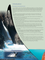
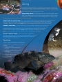
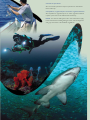
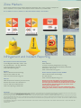
Introduction
Port Stephens–Great Lakes Marine Park
The Port Stephens–Great Lakes Marine Park (PSGLMP) was declared on 1 December 2005 under
the Marine Parks Act 1997. It covers an area of approximately 98,000 hectares and includes offshore
waters to the 3 nautical mile limit of state waters between Cape Hawke Surf Life Saving Club and
Birubi Beach Surf Life Saving Club and all estuarine waters of Port Stephens and the Karuah River,
the Myall River, Myall and Smiths Lakes and all of their creeks and tributaries to the limit of tidal
influence.
This multiple use Marine Park represents an opportunity to protect some of the state’s most
spectacular and rich marine biodiversity while providing for sustainable use. The outstanding
features of the Marine Park include:
• Broughton Island, the second largest island in NSW, which provides important habitat for the
threatened grey nurse shark and black cod;
• Cabbage Tree Island (John Gould Nature Reserve), the primary breeding site for the
threatened seabird Gould’s petrel;
• The majority of islands, reefs, beaches and rocky intertidal areas in the bioregion, providing
significant habitats for the diverse fauna and flora, with five areas identified as major habitat
sites for the grey nurse shark;
• Extensive and diverse estuaries and shorelines of Port Stephens and the Great Lakes
regions including remarkable features such as the largest drowned river valley in NSW
(Port Stephens), the largest brackish barrier lake system in NSW (Myall Lakes), and the
largest intermittently open and closed lake in NSW (Smiths Lake);
• The largest areas of mangrove and saltmarsh in the state, and 5 percent of the seagrass
area in NSW;
• Important socio-economic values including quality recreational fishing and productive
commercial fishing grounds, aquaculture, many popular scuba diving sites, and
regionally significant tourism activities such as whale and dolphin watching;
• Many heritage listed sites, such as the spectacular lighthouses at Point Stephens
and Seal Rocks;
• A multitude of historic shipwrecks including the Satara, Oakland, Catterthun,
and Macleay.
Many significant Indigenous cultural and spiritual sites are located within or
adjacent to the Marine Park including middens, burial sites and traditional
campsites. Aboriginal association with the sea and land in the area
dates back thousands of years, and many traditional practices are still
undertaken today, including fishing and collecting.
Zoning
The PSGLMP Zoning Plan enhances conservation of marine habitats and species by
providing various levels of protection whilst allowing for multiple use. The four types
of zones that are applied in NSW marine parks are sanctuary zones, habitat protection
zones, general use zones and special purpose zones.
SANCTUARY ZONES provide the highest level of protection for habitats, animals
and plants, ecological processes, natural features and areas of cultural significance by
allowing only activities that do not harm plants, animals or habitats. Many recreational
activities can be conducted in sanctuary zones including guided tours, boating, surfing,
snorkelling, diving and permitted research and educational activities.
HABITAT PROTECTION ZONES help to conserve marine biodiversity by protecting habitat and reducing high impact
activities. A range of activities that are of social, commercial and economic importance to the area may continue in
habitat protection zones, including recreational fishing, some forms of commercial fishing, tourist activities and fishing
competitions. Habitat protection zones prohibit fish and prawn trawling and estuary mesh and estuary haul netting.
GENERAL USE ZONES provide for a wide range of environmentally sustainable activities including both
commercial and recreational fishing. General use zones complement other marine park zones and provide
an integrated approach to the management and use of the Marine Park. General use zones allow for a
variety of activities including trawling but excluding longlining, setlining and droplining. These zones
are also found throughout the inlets, bays, estuaries, rivers, creeks and lakes in the Marine
Park.
SPECIAL PURPOSE ZONES provide for the specific management of
aquaculture, fish-feeding, marinas and other vessel related facilities, commercial
and residential facilities, fisheries and aquaculture research at a number of
locations throughout the Marine Park.
Permits
A variety of activities undertaken in the Marine Park
require permits from the Marine Parks Authority
including:
• Commercial activities
• Collecting for commercial and private
aquariums
• Competitions including line fishing and
spearfishing
• Hovercrafts, airboats and seaplanes
• Traditional Indigenous fishing use
• Organised events including sporting
or other activities
• Research
General Activities Guide
Domestic animals
Domestic animals are permitted within the Marine Park.
However domestic animals are not permitted on, or in,
waters that are reserved under the National Parks and Wildlife
Act 1974 or beaches directly seaward of such reserves. The
exception to this applies if they are assisting a disabled person,
are a police dog, or if the owner has a Marine Parks Authority
Permit, for such a purpose.
Vehicles
Vehicles are permitted on beaches of the Marine Park for the
purpose of launching and retrieving vessels from designated
boat launching facilities, or other beaches subject to Local
Government and National Parks and Wildlife Service
requirements.
Fish cleaning
Fish or fishing gear cannot be cleaned in a sanctuary zone.
Trawl nets can be cleaned whilst transiting through a sanctuary
zone provided the otter boards are out of the water and the
cod-ends are open.
Anchoring
Anchoring is not permitted on seagrass beds in sanctuary
zones. Vessel operators must ensure that no part of the
anchor, chain, rope or vessel makes contact with a seagrass
bed.
Speed restrictions in sanctuary zones
A 4 knot speed limit applies within the designated ‘speed
restriction area’ of the Fly Point - Corrie Island sanctuary zone
and the entirety of the Jimmys Beach sanctuary zone. These
locations are recognised dolphin resting areas, particularly for
females with calves.
Taking of certain plants in habitat protection and general use
zones
For recreational purposes, it is permissible to hand collect sea
lettuce (Ulva lactuca) and bait weed (Enteromorpha intestinalis)
in habitat protection and general use zones.
Seasonal closure - commercial
The mouth of the Myall River at Bombah Broadwater is closed
to commercial netting from the 1 May to 31 August each year.
Habitat protection zone permitted fishing activities
The fish species listed in Table A can be taken from habitat
protection zones by the following fishing methods:
• Line fishing
• Hand gathering
• Spearfishing
• Scoop net, landing net, push net, scissor net, lift net
Commercial submersible lift net (bait) and purse seine net
are permitted only in the following locations within a habitat
protection zone of the Marine Park:
• Broughton Island - west of Cod Rock on the southern side
and west of Flat Rock on the northern side and no more
than 1 kilometre seaward of the mean high water mark
• the Cabbage Tree Island habitat protection zone
• within 500 metres of Tomaree Head
• within 2 kilometres of Point Stephens at 32°44.900’S,
152°12.066’E
Commercial prawn net (set pocket) is permitted only in the
Smiths Lake habitat protection zone and the Myall River Camp
habitat protection zone.
Commercial haul netting is permitted only from the following
beaches in habitat protection zones:
• Boat Harbour Beach, One Mile Beach, Samurai Beach,
Fingal Beach, Fingal Spit, Bennetts Beach, Mungo Beach,
Boat Beach, Number One Beach, Shelly Beach, Elizabeth
Beach, Seven Mile Beach and Lighthouse Beach (Sugarloaf
Point).
Little Beach restrictions
The following restrictions apply in the Little Beach habitat
protection zone:
• no collecting
• taking of fish by hand held line only
• Land based line fishing is the only method of fishing permitted
in the Little Beach Habitat Protection Zone. Fishing is only permitted from the wheelchair access jetty, the Little Beach Jetty
and the beach between these jetties. Fishing from water craft is
not permitted by any means in the area
• berleying is not permitted.
Diving restrictions in grey nurse shark critical habitats
Dutchmans Beach restrictions
No collecting is permitted in the Dutchmans Beach habitat
protection zone.
The following SCUBA diving activities are not permitted in
declared grey nurse shark critical habitat areas:
• night diving
Broughton Island, Sawtooth and Edith Breakers restrictions
• blocking an entrance to a cave or gutter containing a shark
The following restrictions have been implemented to minimise
potential impacts on key grey nurse shark aggregations:
• feeding or touching a shark
• NO FISHING FROM ANCHORED VESSELS: Fishing,
spearfishing, lobster gathering or trapping is not permitted
from vessels anchored in either the hatched Sawtooth or
Broughton Island habitat protection zones.
• wearing or using an electronic shark repelling device
• FISHING WITH BAIT IS PROHIBITED: It is only permitted
to take or attempt to take fish by way of artificial lure,
artificial fly, fish trap, lobster trap, hand picking, spear or
speargun in Broughton Island, Sawtooth or Edith Breakers
habitat protection zone.
• chasing or harassing a shark
• using a powered scooter
The following areas within the Marine Park are declared critical
habitats for the grey nurse shark (as at January 2007):
• The Pinnacle
• Big Seal and Little Seal at Seal Rocks
• Little Broughton Island
Cabbage Tree Island restrictions
Special purpose zones
In the Cabbage Tree Island habitat protection zone fishing
is not permitted except for yellowtail scad (Trachurus
novaezelandiae), slimy mackerel (Scomber australasicus) and
garfish (all species).
Fish and/or plants can only be taken in a special purpose zone
if a habitat protection zone or a general use zone adjoins the
special purpose zone. The same provisions and restrictions
apply to that of the adjoining habitat protection or general use
zone.
It is unlawful to be in possession of any fish other than the
bait fish species mentioned above in the Cabbage Tree Island
habitat protection zone (exemption exists for commercial
fishers only).
Setlining/droplining
Setlining and droplining are not permitted in the Marine Park.
Vessel lights can confuse and stress little penguins and Gould’s
petrels returning to their nests on Cabbage Tree Island at night.
For these reasons light restrictions have been implemented in
the Cabbage Tree Island habitat protection zone:
Seaplanes, hovercrafts and airboats
• No lights can be switched on for longer than 5 minutes in
any 60 minute period, except for:
Motorised water-sports
– a light required to be used under the Navigation Act
1901 or the Marine Safety Act 1998, or
– a bait collection light suspended less than 5m high and
which projects a spread of light downwards that is less
than 20 metres at its widest point.
Open Ocean restricted habitat protection zone restrictions
The following restrictions apply in the Open Ocean restricted
habitat protection zone:
• Taking of fish by recreational trolling only permitted
between 1 December and 30 April (inclusive) each year.
• No other fishing methods permitted.
• No fishing from anchored or drifting vessels.
A permit is required from the Marine Parks Authority to
operate a seaplane, hovercraft or airboat on the waters of the
Marine Park.
Motorised water-sports are not permitted in sanctuary zones,
except for Smiths Lake and Boolambayte Lake sanctuary zones,
or, via a Marine Park permit, in the Fly Point - Corrie Island
sanctuary zone.
Motorised water-sport means the following:
(a) irregular driving
(b) towing a water skier or aquaplaner with a motorised vessel
Personal Water Craft (including jetskis) are not permitted
within 200 metres of the shore in the Dutchmans Beach
habitat protection zone.
Vessels travelling through sanctuary zones
All vessels may transit through a sanctuary zone.
• Bait use is permitted whilst trolling.
Vessels must stow any fishing gear whilst transiting a sanctuary
zone.
• All fishing is prohibited within this zone between 1 May and
30 November (inclusive) each year.
Vessels anchored, moored or aground in sanctuary zones must
have all fishing lines unrigged.
Trawlers must have the cod end of a trawl net open and the
otter boards out of the water whilst transiting a sanctuary
zone.
Commercial operations
All commercial operations require a permit from the Marine
Parks Authority.
Competitions, organised sports and other organised activities
All competitions, organised sports or other organised activities
require a permit from the Marine Parks Authority.
NOTE: The Fisheries Management Act 1994 continues to apply
in the Marine Park including fishing closures, size and bag limits
and grey nurse shark critical habitat regulations.
Table A: Habitat protection zone permissible fish species
Common Name
Class/Family
Species
Finfish
Class Osteichthyes
All species
Shark, ray
Class Chondrichthyes
All species
Lobster, crayfish
Family Palinuridae
All species
Slipper lobster
Family Scyllaridae
All species
Prawn
Family Penaeidae
All species
Squid
Family Sepiidae
All species
Cuttlefish
Family Spirulidae, Sepiidae and Sepiadariidae
All species
Beach worm
Family Onuphidae
All species
Ghost shrimp, marine yabby (nipper)
Family Callianassidae
All species
Mud crab
Family Portunidae
Scyalla serrata
Blue swimmer crab
Family Portunidae
Portunus pelagicus
Rock crab
Family Grapsidae
All species
Oyster
Family Ostreidae
Saccostrea spp. and Crassostrea spp.
Akoya pearl oyster
Family Pteriidae
All species
Pipi
Family Donacidae
All species
Cockle
Family Orcidae
All species
Clam
Family Veneridae
All species
Mussel
Family Mytilidae
All species
Scallop
Family Pectinidae
All species
Sea urchin
Family Strongylocentrotidae
All species
Cunjevoi
Family Pyuridae
All species
Turban shell
Family Turbinadae
Turbo spp.
Abalone
Family Haliotidae
Haliotis rubra
Periwinkle
Family Trochidae
Austrocochlea spp.
NOTE: Except as otherwise protected under the Fisheries Management Act 1994.
Zone Markers
Zone markers indicate zone boundaries within the Marine Park and come in a variety of shapes and
sizes as required to suit a specific site. Examples of these markers are provided below.
It is an offence to moor a vessel to, or otherwise interfere with, a zone marker.
Infringement and Incident Reporting
Port Stephens-Great Lakes Marine Park
Locked Bag 800, Nelson Bay NSW 2315
Ph: (02) 4984 8270 Fax: (02) 4984 8271
email: [email protected]
Web: www.mpa.nsw.gov.au
Pollution
Office of Environment and Heritage
Environment Hotline 131 555
Web: www.environment.nsw.gov.au
Fisheries
NSW Department of Industry and Inves tment
Fisheries Information Line 1300 550 474
24 Hour Watch Line 1800 043 536
Web: www.dpi.nsw.gov.au/fisheries
Disclaimer
Boating
NSW Maritime
Licences and Testing, Registrations, Moorings,
Weather Forecasts, Commercial Vessels certification
information. Ph: 131 236
Web: www.maritime.nsw.gov.au
Marine Mammal, Reptile and other Wildlife
Office of Environment and Heritage
Ph: 1300 361 967
Web: www.nationalparks.nsw.gov.au
Please be warned that $500 on the spot fines and heavy
penalties of up to $110,000 apply for infringements against
the zoning plan and breaches of the Marine Parks Act 1997,
the Marine Parks Regulation 2009 and the Marine Parks
(Zoning Plans) Regulation 1999.
There are also the provisions for the confiscation of fish,
fishing gear, boats, trailers, vehicles and other equipment.
This brochure provides a plain English guide to the zoning for the Port Stephens - Great Lakes Marine Park. Full details of the zoning plan are contained in the Marine Parks (Zoning Plans)
Regulation 1999 via the website www.legislation.nsw.gov.au. this brochure should not be used for navigation or legal interpretation purposes.
No warranty is given that this User Guide is free from error or omission. This User Guide should not be used as an aid in determining whether an activity is safe to perform. Users of this
guide should satisfy themselves of the accuracy of the information contained herein through their own enquiries. The NSW Marine Parks Authority and its servants and agents expressly
disclaim liability for any act done, or omission made, based on the information in this User Guide and any consequences of any such act or omission. The information contained in this User
Guide may be subject to change.
PHOTOGRAPHY: Little Penguin - G Robertson DEC ©; Gould’s Petrel - DEC ©; Fisher - DEC ©; Humpback Whale - Simon Allen ©; Underwater Photos - David Harasti © All other
photos supplied by MPA ©
PSGLMP 03/13