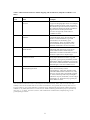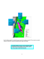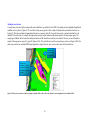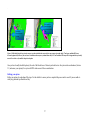
1
Australia’s South-east Marine Region: A User’s Guide
to Identifying Candidate Areas for a Regional
Representative System of Marine Protected Areas
August 2003
http://www.ea.gov.au/coasts/mpa/
© Commonwealth of Australia 2003
Information contained in this publication may be copied or reproduced for study,
research, information or educational purposes, subject to inclusion of an
acknowledgment of the source and provided no commercial usage or sale of the
material occurs. Reproduction for purposes other than those given above requires
written permission from Environment Australia. Requests for permission should be
addressed to:
Assistant Secretary
Parks Australia South
Environment Australia
GPO Box 787
CANBERRA ACT 2601
Disclaimer:
This paper was prepared by Environment Australia, CSIRO Marine Research and the
National Oceans Office to assist with the process of identifying marine areas for
inclusion within a representative system of marine protected areas as part of the
South-east Regional Marine Plan. The views and opinions expressed in this
publication are not necessarily those of the Commonwealth. The Commonwealth does
not accept responsibility for the contents of this report, and shall not be liable for any
loss or damage that may be occasioned directly or indirectly through the use of, or
reliance on, the contents of this publication.
ISBN: 0 642 54950 8
Contents
About this user’s guide
iii
Your input to the process
iv
PART A
1
Section 1 Introduction
1.1 Policy context
1.2 Future representative marine protected area proposals in the
South-east Marine Region
1.3 Process for designing options for a regional representative system of marine
protected areas
Stakeholder consultation
Key outcomes – Stage 1
Key steps – Stage 2
Statutory declaration process
1
1
Section 2 Background to the specifications
2.1 Aim and development of the specifications
2.2 Integration with other spatial arrangements for biodiversity conservation
2.3 Some important considerations underlying the design and use of
the specifications
Surrogates for biodiversity
Achieving comprehensiveness, adequacy and representativeness
Number, size and design of marine protected areas
World Conservation Union (IUCN) categories
6
6
6
PART B
11
Section 3 Specifications for identifying candidate areas for a regional
representative system of marine protected areas
3.1 Applying the specifications
3.2 General considerations
3.3 The regional system of marine protected areas
System-wide considerations
Specifications for identification of options for candidate
representative marine protected areas
Section 4 How to use the specifications and descriptions to help identify
candidate marine protected areas
4.1 Tools and steps to follow in using the specifications
4.2 Checklist
4.3 Worked example for the hypothetical Broad Area of Interest Pycnantha
Identifying a candidate marine protected area
Adding in your interests
Refining your options
i
2
2
3
3
4
4
7
7
9
10
10
11
11
11
12
13
14
19
19
21
23
27
36
37
Glossary
38
References
39
Appendix A - Final draft Environment Australia/National Oceans
Office paper – criteria
Appendix B - Identified conservation measures utilised in the South-east
Marine Region
Appendix C - Representative contacts
Appendix D - Existing marine and coastal protected areas
Appendix E - Broad Area of Interest descriptions
Murray (1A)
Nelson (1B)
Zeehan (1C)
Apollo (1D)
Tasman Fracture (2A)
South Tasman Rise (2B)
Huon (2C)
Offshore Seamount (3A)
Banks Strait (3B)
Bass Basin (3C)
East Gippsland (3D)
ii
41
50
53
54
55
60
63
65
68
70
72
74
76
78
81
83
About this user’s guide
This guide, developed with input from stakeholders and scientific advice, aims to
assist stakeholders to contribute information to the identification and selection of
options for a representative system of marine protected areas (MPAs) in Australia’s
South-east Marine Region.
This guide is in two parts:
Part A includes an introduction and background on general considerations for
designing the regional system of MPAs as a whole. Part A outlines the context and the
evolution of the process to date and will be essential reading for people less familiar
with the process or who have not been directly involved.
Part B includes guidance to stakeholders in the form of specifications, a checklist and
a hypothetical example to help identify options for a representative system of MPAs
using 11 Broad Areas of Interest.
Stakeholders who are familiar with the MPA process in Australia’s South-east Marine
Region, and who have been involved in the evolution of the process over the last few
years, may wish to go directly to Part B of this guide and begin to consider their
options for a system of MPAs in the region.
Additional resources are available on the Environment Australia web site
(http://www.ea.gov.au/coasts/mpa/index.html) including maps showing:
• Broad Areas of Interest for the South-east Marine Region
• Exclusive Economic Zone boundary (200 nautical miles)
• Coastal waters boundary (three nautical miles)
• Geomorphic features
• the Interim Marine and Coastal Regionalisation for Australia (IMCRA)
• Level 2 and 3 bioregionalisations
• Existing marine protected areas in Commonwealth and state waters
• Maps of each of the Broad Areas of Interest in pdf format
Your input to the process
You are invited to use the specifications (Section 3), the description of the 11 Broad
Areas of Interest (Figure 3.1 and Appendix E), the tools in Section 4 and your
knowledge and interests in the region to help identify areas that may contribute to a
representative system of marine protected areas (MPAs) in the South- East Marine
Region. Your information will be used as one of the many inputs to decisions on the
regional reserve design. Support to design your option is available by contacting
either Environment Australia, [phone 02 6274 1767 or email [email protected]
or [email protected] ] or your peak representative body (see Appendix C). It is
expected that leaders of peak industry associations and other non-governmental
groups will coordinate and collate input from and on behalf of their members to
ensure a ‘whole of sector’ development of options.
A series of cross-sectoral workshops commencing in mid-September 2003 will aim to
draw together this information to develop shared options for a regional system of
representative MPAs. Nominated representatives from key stakeholder groups will be
invited to participate in these workshops.
These workshops signal the start of an ongoing consultative process designed to
enable all interested persons to become aware of and to understand the issues
associated with reserve design, to share their knowledge and expertise and to
collaborate toward generally acceptable outcomes for marine conservation in the
region. Please check with your peak representative body and/or the Environment
Australia web site (http://www.ea.gov.au/coasts/mpa/) for information on meetings
and updates on the process.
PART A
Section 1
Introduction
1.1 Policy context
A marine protected area (MPA) is an area of sea (which may include land, the seabed
and subsoil under the sea) established by law for the protection and maintenance of
biological diversity and of natural and cultural resources.
In Australia, the Commonwealth, state and Northern Territory governments are
working together to develop a national system of MPAs that contains representative
samples of Australia’s marine ecosystems – the National Representative System of
Marine Protected Areas (NRSMPA) (Australian and New Zealand Environment and
Conservation Council (ANZECC) 1999). The primary goal of the NRSMPA is to
build a system of MPAs that will be:
-
comprehensive - include MPAs that sample the full range of
Australia’s ecosystems;
-
adequate – include MPAs of appropriate size and configuration to
ensure the conservation of marine biodiversity and integrity of
ecological processes; and
-
representative – include MPAs that reflect the marine life and habitats
of the areas they are chosen to represent.
The NRSMPA exists within a range of national, state and territory management tools
aiming to achieve marine biodiversity conservation. The development of the
NRSMPA fulfils Australia’s responsibilities and obligations under a number of
international conventions and agreements. Australia’s Oceans Policy (1998)
identified the need to accelerate development of the NRSMPA both for conservation
and to give regional security for industry access to ocean resources.
The focus is on developing a representative system of MPAs, as well as individual
MPAs to protect areas of known outstanding conservation significance.
Since the declaration of the Great Barrier Reef Marine Park in 1975, an additional 13
MPAs have been established in Commonwealth waters. These MPAs protect
identified biodiversity values under a variety of World Conservation Union (IUCN)
management categories listed under the Environment Protection and Biodiversity
Conservation Act 1999 ranging from strict nature reserve (IUCN category Ia) to
managed resource protected area (IUCN category VI). The state and Northern
Territory go vernments continue to carry out core functions related to the development
and management of MPAs.
1
1.2 Future representative marine protected area proposals in the
South-east Marine Region
Despite the achievements to date, significant gaps remain in the distribution of MPAs,
especially in deepwater and cooler temperate systems. The priority is to establish
MPAs in large-scale bioregions that are not already represented within the NRSMPA.
Consistent with Australia’s Oceans Policy, future representative MPA proposals
under the Commonwealth component of the NRSMPA will be developed as part of
the regional marine planning process. Conservation of marine biodiversity is
recognised nationally and internationally as being best achieved through strategic
regional marine planning that provides for the establishment and effective
management of a representative system of MPAs and the complementary sustainable
management of adjoining waters (ANZECC 1999).
The South-east Marine Region is the first region identified for planning under
Australia’s Oceans Policy. Accordingly, this is the first time the regional marine
planning process has been used to strategically design a comprehensive, adequate and
representative system of MPAs in Commonwealth waters 1 under the direction of the
National Oceans Ministerial Board. This is also the first time a system- wide approach
has been taken to establish representative MPAs within a large-scale deep offshore
marine region.
The South-east Marine Region’s system of representative MPAs will build on the two
existing Commonwealth MPAs in the region (the Tasmanian Seamounts Marine
Reserve and the Macquarie Island Marine Park) as well as complementing MPAs
established in adjoining state waters (Appendix D). The aim of the system is to ensure
that adequate samples of the full range of the defined bioregions are represented in a
network of MPAs across the region. In addition, the integration of the regional marine
plan and MPA processes provides an exceptional opportunity to consider other
conservation measures when designing the MPA system, and to ensure that MPAs are
not identified in isolation from the management of sustainable resource use.
1.3 Process for designing options for a regional representative system
of marine protected areas
Environment Australia (with statutory and policy responsibility for MPAs) and the
National Oceans Office (with responsibility for regional marine plans) are working
together to ensure a representative MPA system will be integrated into the regional
marine planning framework through the decisions of the National Oceans Ministerial
Board. To achieve this, a two-stage program linked to the delivery of the South-east
Regional Marine Plan has been developed that is both scientifically credible and open
to stakeholder input:
•
Stage 1: (April to December 2002) identified 11 Broad Areas of Interest in the
South-east Marine Region as the focus for identifying and selecting samples of
1
For further information regarding the process for selecting representative MPAs and regional marine
planning see the National Oceans Office web site http://www.oceans.gov.au and the Commonwealth
Department of the Environment and Heritage - Marine Protected Areas web site
http://www.ea.gov.au/coasts/mpa/index.html .
2
the region’s marine biodiversity for inclusion in a regional representative
system of MPAs.
•
Stage 2: (began January 2003) aims to identify and select options for a
regional representative system of MPAs using the Broad Areas of Interest.
Stakeholder consultation
Existing MPA stakeholder processes have been combined with regional marine
planning forums to streamline the process for stakeholders and ensure effective
integration of MPAs with the South-east Regional Marine Plan. The key forums
consulted were:
• Commonwealth Marine Protected Areas Committee: a forum for relevant
Commonwealth go vernment agencies to provide input into the
Commonwealth MPA process and integrate complementary marine
environment management objectives, such as spatial management of fisheries
and MPAs;
• Commonwealth Marine Protected Areas Stakeholder Reference Group: a
forum for integrating the expertise and views of non- government stakeholders
into Commonwealth policy for MPA development;
• Natural Resource Management Council’s Taskforce on Marine Protected
Areas: a forum of Commonwealth and state agencies to progress the
development of the NRSMPA;
• South-east Regional Marine Plan Working Group: a forum of representatives
from key stakeholder groups in the South-east Marine Region to assist in the
development of the South-east Regional Marine Plan; and
• Focus Group: a small sub-group of the Stakeholder Reference Group and
South-east Regional Marine Plan Working Group to provide expert advice on
the detailed outputs and processes for consideration by the broader stakeholder
forums.
In addition, Environment Australia and the National Oceans Office have addressed
specific sectoral concerns with stakeholders through a series of one-on-one meetings
at their request.
Key outcomes – Stage 1
Through these forums, Environment Australia and the National Oceans Office
developed operational criteria to identify and select a comprehensive, adequate and
representative system of MPAs (Appendix A). These criteria are derived from the
ANZECC (1998) guidelines for establishing the NRSMPA. This is the first time these
criteria have been interpreted for application within a large-scale, deep, offshore
marine region.
Using the operational criteria, 11 Broad Areas of Interest were identified (Figure 3.1).
The 11 areas were based on the bioregionalisations of IMCRA (on the continental
shelf) (IMCRA Technical Group 1998) and the interim offshore regionalisation
(Butler et al. 2001) developed for the National Oceans Office as part of the South-east
Regional Marine Plan process, as well as other existing biological and physical data
and information. Development of the Broad Areas of Interest from those
regionalisations was done through a combination of scientific modelling, expert
opinion and the exchange of stakeholders’ ideas and information.
3
The Broad Areas of Interest are not candidate MPAs. They are intended to provide
stakeholders with some certainty over which marine areas may be sampled for
possible inclusion within an MPA.
Key steps – Stage 2
Key steps in Stage 2 of the process are:
1. Specifications have been developed to help identify samples of marine
areas within the Broad Areas of Interest that are comprehensive, adequate
and representative (Section 3).
2. Through this user guide, stakeholders are invited to apply the
specifications in the context of their knowledge of the region (especia lly
socio-economic and cultural interests) to develop options for a regional
system of candidate representative MPAs. A hypothetical example is
provided in Section 4.3 to show how to use the specifications.
3. Representatives of key stakeholder groups will be invited to bring this
information to a series of workshops commencing in mid-September 2003.
In these workshops stakeholder information will be combined with the best
available information on ‘representative’ features and ecological
considerations assembled by the Commonwealth Scientific and Industrial
Research Organisation (CSIRO) to develop options for a regional system
of representative MPAs that satisfy the requirements of the specifications
with reference to socio-economic or cultural issues.
4. Using the results of step 3, Environment Australia and the National Oceans
Office will work with other government agencies to ensure whole-ofgovernment consideration of these options. As part of the evaluation
process these options will be subject to stakeholder examination and input.
The overall aim is to develop options that achieve a comprehensive,
adequate and representative system of MPAs that respects the interests of
all stakeholders.
5. It is intended that these options will be presented to the National Oceans
Ministerial Board in late 2003 for consideration as part of the final Southeast Regional Marine Plan.
Statutory declaration process
Following consideration by the National Oceans Ministerial Board it will then be
necessary for each candidate area recommended as an MPA to be considered
individually through the statutory processes for marine reserve declaration. 2
A notice inviting public comment on each MPA proposal must be published,
specifying proposed boundaries, purposes and IUCN category. The minimum period
for comment is 60 days. Consultation on all native title issues is in accordance with
the Native Title Act 1993. A regulatory impact statement may also be prepared. On
this basis the Director of National Parks prepares a report to the Minister for the
Environment and Heritage. The report must include any comments received and the
2
The statutory process for declaring Commonwealth reserves is set out in chapter 5, part 15, division 4
of the Environment Protection and Biodiversity Conservation Act 1999. A summary of this process can
be found on the Environment Australia web site www.ea.gov.au/coasts/mpa/ - see Commonwealth
Marine Protected Areas Program.
4
Director’s views on the comments. If the Minister is satisfied that a reserve should be
declared the Governor-General is advised accordingly. Only when these steps are
taken may the Governor-General make a proclamation declaring the area to be a
Commonwealth reserve by publishing the declaration in the Commonwealth
Government Gazette.
5
Section 2
Background to the specifications
2.1 Aim and development of the specifications
The aim of the specifications is to help identify comprehensive, adequate and
representative samples of key bioregions within and across 11 Broad Areas of Interest
for the South-east Marine Region (see Section 2.3). The specifications aim to guide
stakeholders to identify these areas using the best available information on
‘representative’ features and ecological considerations (see Appendix E).
The specifications are non-technical and range from broad precautionary
specifications for areas where there is very little knowledge, to specifications based
on current understanding of the system for areas where more information is available.
The specifications are designed for ease of interpretation to allow stakeholders to add
in their socio-economic and cultural interests.
The specifications were developed initially by CSIRO in consultation with scientists
from other agencies. They build on the biodiversity and other environmental criteria
(identification criteria) agreed with stakeholders during 2002 (Appendix A). The
specifications have been subject to stakeholder input and independent scientific peer
review.
2.2 Integration with other spatial arrangements for biodiversity
conservation
The specifications deal primarily with MPAs as one tool for achieving biodiversity
conservation with the aim of ensuring that a representative system of MPAs is
developed in the South-east Marine Region.
Other actions to progress biodiversity conservation outcomes such as species-specific
conservation and the mana gement of marine resource use, for example through
fisheries spatial arrangements, should be linked to MPAs through the specifications to
the extent that the actions have complementary objectives for protecting
representative habitats and marine biodiversity. The representative system of MPAs in
the South-east Marine Region will contribute to conservation outcomes in the broader
context of the South-east Regional Marine Plan as well as the range of state and
national mechanisms to achieve biodiversity conservation. Ease of management is an
important consideration in reserve design in terms of ensuring community support,
compatibility with existing management regimes and effective compliance and
enforcement.
6
2.3 Some important considerations underlying the design and use of
the specifications
The specifications have been developed within the context of limited data for largescale, deep-water, offshore marine environments and Commonwealth policy on
MPAs. Some important considerations affecting the design and use of the
specifications are described below.
Surrogates for biodiversity
Typically the assessment of an area proposed for an MPA requires information on
biodiversity (including ecosystem mapping), ecological processes, conservation
status, biogeographic characteristics, social interests (including data relating to
Indigenous and non-Indigenous values), economic interests (including existing and
potential uses) and threatening processes.
In the South-east Marine Region our knowledge of conservation va lues, resources,
activities and uses is rapidly changing and improving. For example, recent surveys
sponsored by the National Oceans Office have extended the coverage of seafloor
maps of the region and our understanding of the structural features of deep-sea
habitats, unveiling details of spectacular features such as canyons, seamounts and
fractures. Similarly, descriptions of uses and threatening processes have been
undertaken at the regional level as part of the assessment process for the South-east
Regional Marine Plan. However, the level of fine-scale information for MPA
decision- making is very limited. As acquiring this information is costly and will take
many decades, a precautionary approach to reserve system design is taken. This uses
the best scientific understanding of surrogates for broad-scale ecosystems and habitats
based on bioregional assessments as well as the advice and expertise offered by
stakeholders.
The two core regional datasets that underpin the specifications and the descriptions of
the Broad Areas of Interest are:
• the Interim Bioregionalisation of the South-east Marine Region (NOO 2002;
Butler et al. 2002) for the deepwater areas outside the continental shelf; and
• the Interim Marine and Coastal Regionalisation for Australia (IMCRA 3.1,
ANZECC 1998) for areas on the continental shelf to the 200 metre isobath.
The hierarchical structure of the deepwater bioregionalisation (briefly explained in
Table 2.1) is defined at three scales: the large-scale provinces (Level 1 - biomic),
(Level 2a and 2b - shelf, slope and abyssal plain) and geomorphic units (Level 3 features such as a field of seamounts, or a seamount, canyons etc). Level 3 are the
finest scale units and are used to provide information about the type of biological
assemblages that might occur in a given area (NOO 2002).
7
Table 2.1 Hierarchical scheme for habitat mapping and classification (Adapted from Butler et al.
2001).
Level
Name
Examples
1
Province
Large-scale biogeographic units. For example,
IMCRA Technical Group (1998) recognised
three demersal provinces and two biotones on
the continental shelf in the South-east Marine
Region and one for Macquarie Island.
Provinces are typically of the order of
~1000km in extent.
2
2a Biome
Continental shelf, slope, abyssal plain and
offshore continental blocks (e.g. South
Tasman Rise) are dictated by gross
geomorphology. These are nested within
provincial units and are typically several
hundreds of kilometres or more in extent.
2b Sub-biomes
Shelf-break and upper slope; lower slope.
These subdivisions are dictated by the
distributions of animal communities, some of
which have quite narrow depth ranges.
2c Mesoscale units
Along-slope subdivisions within, e.g. midslope units, again typically dictated by faunal
distributions. IMCRA identified 12 mesoscale
units on the continental shelf in the South-east
Marine Region, from 50 to 350km in size.
Geomorphological units
Areas characterised by similar
geomorphology. These may include (on the
continental shelf) fields of sand-waves, rocky
outcrops, incised valleys, flat muddy seabeds,
etc. and (on the slope and at abyssal depths)
submarine canyons, seamounts, oceanic ridges
and troughs, etc. Such units may typically be
about 100km in extent.
3
Note in Table 2.1 that size is not a criterion for level in the hierarchy. Thus, some Level 2b units may
actually cover less area than some Level 3 units. Nevertheless, size typically decreases from Level 1 to
Level 3. Table 2.1 gives some indicators of spatial extent. Although the hierarchical scheme described
in Butler et al. (2001) had at least seven levels, the South-east Bioregionalisation project reported only
on Levels 1 – 3; that is, provinces, biomes, some subdivisions within biomes, and fairly large-scale
geomorphological units.
8
In the deepwater regionalisation, biological data was available for a wide area and
provided useful information about the large-scale spatial pattern of diversity. This
included data from collections of benthic and demersal fish and invertebrates, mainly
from the outer shelf and upper continental slope. This biological data helped identify
three broad biogeographic provinces in the South-east Marine Region but was not
adequate to identify fine structure within those provinces. Finer patterns are inferred
from surrogate data sets such as nutrients, temperatures, oxygen and salinity, ocean
currents, bathymetry, seabed characterisation and sediment data and modelling. These
are reasonable surrogates for large-scale patterns of diversity. For example, it is
known that different suites of organisms occur at different depths, at different water
temperatures, or in different sediment types. It is therefore expected that one spatial
unit, for example sediment type, is likely to contain a different suite of organisms and
ecological processes from a different spatial unit. By representing the different spatial
units, identified by surrogates such as sediment type, in a system of MPAs we can
reasonably assume we are representing the diversity of life within the region.
Howeve r, as surrogates tell us little about the details of those organisms or their
ecological processes decisions about MPAs, especially in deepwater ecosystems, will
be made in the face of uncertainty and a considerable lack of knowledge.
Achieving comprehensiveness, adequacy and representativeness
The specifications are designed to help identify samples of marine areas within the
Broad Areas of Interest that meet the NRSMPA principles of comprehensiveness,
representativeness and adequacy.
While all three principles are equally desirable for an effective system of MPAs, the
use of surrogates for biodiversity due to the lack of fine-scale information on viability
of populations, species and communities makes practical consideration of
comprehensiveness and adequacy relatively more difficult than representativeness.
For this reason, representativeness is the primary driver for identifying potential
samples of the Broad Areas of Interest to ensure the diversity within each bioregion is
sampled with a system of candidate MPAs.
In addressing comprehensiveness, the Broad Areas of Interest were designed to
ensure that the full range of Level 3 bioregions that exist within the South-east Marine
Region could potentially be sampled within candidate MPAs. Adequacy is
determined by the size and number of MPAs (see below). It is essentially a risk
management concept and can be enhanced directly through reserve management,
replication of ecosystems within MPAs and complementary management of adjacent
marine areas. Where data on ecosystems, communities and/or species distributions
exists it should be incorporated to improve the identification of marine areas that also
contribute to adequacy and comprehensiveness.
9
Number, size and design of marine protected areas
In designing an MPA or network of MPAs consideration of size, shape and spacing is
important. These design issues will be guided by the specifications as well as systemwide considerations (Section 3.3). As MPAs can operate at a variety of scales for a
range of marine biodiversity objectives, percentage targets and/or other quantitative
rules are not used to prescribe the size of the MPA. Instead, the process focuses on
meeting a broad range of specifications designed to ensure that the candidate MPAs
reasonably reflect the range of features and ecosystems and the biotic diversity within
the South-east Marine Region.
Socio-economic and cultural considerations, as well as issues of management
practicality and feasibility, will also influence the boundaries and number of
individual MPAs and the design of the system as a whole. For example, opportunities
will be sought to integrate MPAs with spatial management in other sectors (e.g.
fisheries management habitat protection and infrastructure corridors) where the
objectives of these other forms of spatial management and MPAs overlap.
In this way, the number, size and design of the candidate MPAs will be determined in
consultation with stakeholders considering conservation objectives and socioeconomic and cultural interests. The final system of MPAs will be the one that best
achieves the principles of comprehensiveness, adequacy and representativeness while
respecting the interests of all stakeholders.
World Conservation Union (IUCN) categories
The Environment Protection and Biodiversity Conservation Act 1999 requires the
assignment of one or more IUCN category to Commonwealth reserves including
MPAs. Just as there are no targets for setting aside a certain percentage of the region
for MPAs, nor are there any targets for allocation of MPAs to any particular IUCN
category. However, for adequate protection of biodiversity it is appropriate that there
be a range of management regimes, from highly protected areas to sustainable use
MPAs, within each major ecosystem type (ANZECC 1998; Commonwealth of
Australia 2003). In applying this to the South-east Marine Region each candidate
MPA will aim to contain a highly protected area (IUCN categories I and II) to ensure
that samples of representative ecosystems are managed in as undisturbed a state as
possible. This precautionary approach to the level of reservation secures one of the
key outcomes of the NRSMPA by guaranteeing high protection of a sample of the
region’s marine biological diversity.
The type, size and location of IUCN categories to be assigned to candidate MPAs will
be determined on a case-by-case basis in consultation with stakeholders using all the
information available for the area including ecological and socio-economic values.
Categories can only be usefully discussed when the characteristics and objectives of a
potential reserve and the specific conservation values under protection are known. As
explained in Section 1.3, the public is invited to comment on all MPA proposals,
including the IUCN category.
10
PART B
Section 3
Specifications for identifying candidate
areas for a regional representative system of marine
protected areas
3.1 Applying the specifications
The assessment of an area as a candidate MPA requires information on biodiversity,
ecological processes, conservation status, biogeographic characteristics, social,
cultural and economic interests and threatening processes. In the assessment process,
specifications based on ecological criteria (Appendix A) are first used to help identify
candidate MPAs (tha t is, to help identify preferred general areas within which MPAs
may be selected). Stakeholders may incorporate social, economic and cultural
information in applying the specifications to help maximise the conservation and
socio-economic benefits and minimise any potential for adverse impacts.
The specifications are flexible because of the limits of the information base, the
variety of state and Commonwealth legislative and management frameworks,
requirements for cost-effective management and enforcement and overall reserve
system design (see Section 3.3). For these reasons areas closely adjacent to a Broad
Area of Interest may be considered for sampling. Not all areas identified need result in
an MPA and consideration must also be given to the most effective tool for achieving
conservation objectives (see Section 2.2 and Appendix B). While in principle all
specifications should be met, one or more specifications may be considered to have
greater ‘weight’ in the identification process. Section 4, including a checklist, will
guide you in using the specifications.
For areas on the continental shelf, the specifications will apply to each IMCRA region
so that a sample of each broad biogeographic area defined at the meso-scale level
(hundreds to thousands of kilometres) is identified for inclusion within a candidate
MPA. For areas outside the continental shelf the specifications are, at a minimum,
designed to include a sample of each Level 2 biome within a candidate MPA. The
reliance on physical surrogates to infer patterns of biodiversity (as discussed in
Section 2.3) means that the readily identifiable features (Level 3 units) such as
submarine canyons, seamounts, cinder cones, oceanic ridges and troughs are
important attributes for inclusion within candidate MPAs.
3.2 General considerations
In the descriptions of the Broad Areas of Interest (Appendix E), conservation values
have been described subject to the available information. 3
In arriving at the Broad Areas of Interest, and now in seeking to identify sites for
candidate MPAs, surrogates are used for biodiversity (depth, water properties,
3
Due to time constraints this information compiled by CSIRO from a variety of sources is not
comprehensive and there may be resources that have not been accessed to date. New data will continue
to be acquired and included as part of the process of identifying candidate MPAs.
11
geological and geomorphological data) and in only a few areas do we have some
biological data to guide us. As explained in Section 2.3 these surrogates are sufficient
to tell us that the different units are likely to differ in their benthic and demersal fauna.
They do not tell us in detail what those fauna are or their ecology (length of life,
critical habitat, adult home ranges, larval dispersal distances, trophic relationships
between species, etc.). It is therefore not possible to write specifications based on that
sort of understanding, nor will this be possible in the foreseeable future.
Other conservation values that are not specifically associated with the site in question
(and might not normally be addressed using an MPA) may nevertheless add
conservation value to the site. For example, if an area has attributes (fixed in space
and appropriate to an MPA) that make it a good candidate for an MPA focused on
biodiversity conservation and part of a representative system, then its value may be
further strengthened if it is also, for example, a migration route for some highly
mobile species or an area of great scenic beauty. This idea of complementarity is in
addition to, and distinct from, the idea that MPAs should be designed to be
complementary to other management measures.
The specifications include unique features in an MPA system. This is a general
principle of MPA design and, by definition, of the design of a representative system.
An example would be the Bass Canyon which, with its winter cascade but summer
upwelling processes, is an oceanographic feature peculiar to this region and likely to
have important productivity and unique biodiversity and ecological dynamics.
Finally, it is a general principle of MPA design to avoid, where possible, ‘putting all
your eggs in one basket’. Replication of (apparently) similar MPAs contributes to the
adequacy of the reserve system overall. Replication is essentially insurance against
the loss of natural values due to events outside management control (such as a major
marine pollution event), which may significantly reduce or negate the reserve for its
specified purposes (ANZECC 1998). Replication also increases the chance tha t we
will capture habitat diversity that is presently unknown (because we have only coarse,
surrogate-based information for most units).
These specifications are considered to provide guidance on the necessary minimum
requirements to achieve a comprehens ive, adequate and representative sample of
marine areas for inclusion within a candidate MPA. All specifications are given for
good reasons, and a balance between them is necessary. Overall the objectives of each
candidate area need to be considered in terms of the contribution of individual
reserves to marine biodiversity protection and to the system of MPAs as a whole.
3.3 The regional system of marine protected areas
As described above, the system of MPAs will be primarily based on the principle of
protecting representative samples of the region’s marine ecosystems. While the
specifications provide guidance on how to identify a sample of each of the key
bioregions as the basis for ensuring representativeness within candidate MPAs, the
candidate areas also need to be considered and prioritised in terms of their
contribution to the regional system.
This identification process will involve constant feedback as each identified area is
assessed in terms of its merits as a candidate MPA (using the specifications) and in
12
terms of its contribution to the NRSMPA (using system- wide considerations). This is
especially important for marine systems, due to the extent that species may be
migratory and highly mobile or depend on very different and geographically separated
ecosystems for different stages of their life cycle. The high degree of
interconnectedness between marine ecosystems means there is also a high degree of
interdependence, which must be taken into account in designing an integrated reserve
system.
System-wide considerations
System-wide objectives for the South-east Marine Region were first developed with
stakeholders as part of the operational criteria for identifying and selecting a system of
MPAs in the region (Appendix A). Further stakeholder consultation and
recommendations by the peer review panel have led to refinement of this vision for
the regional network of MPAs as a whole. On this basis a viable system of MPAs in
the South-east Marine Region will aim to:
1. address gaps and priorities for the conservation of marine ecosystems across
the region to enhance the representativeness of the region’s reserve system by
considering other conservation tools and existing MPAs (see Appendices B
and D);
2. seek opportunities to integrate fisheries and other sectoral spatial arrangements
with MPAs in the region where complementary objectives are identified, e.g.
protection of representative benthic habitat;
3. include a small number of large MPAs rather than a large number of small
MPAs to ensure practical and feasible management;
4. include MPAs of a size and shape that are ecologically robust in terms of
protecting what is known about the conservation values of the marine area;
5. obtain the best possible arrangement of MPAs in terms of spacing and
orientation according to what is known about migration patterns, currents and
connectivity among ecosystems;
6. consider vulnerability of areas to disturbance and seek replication of key
features;
7. contain a network of MPAs with IUCN categories ranging from strict nature
reserve to managed resource protected area where these are compatible with
the objectives of the MPA;
8. contain MPAs that will each aim to include a highly protected area (IUCN
categories I or II) as a scientific reference site and to ensure that samples of
representative systems are managed in as close to an undisturbed state as
possible;
9. maximise benefits to all stakeholders to build support and community
ownership of the MPA system; and
10. include regular review of the effectiveness of the system.
Specifications for identification of options for candidate representative marine
protected areas
The specifications are set out in Table 3.1 and grouped under the following headings
for convenience of use, and in general order of priority:
• Primary specifications concerning representativeness, including special and
unique features
13
•
•
Particular ecological specifications
General specifications on size and shape
Reasons for some of the specifications are explained under Section 3.2 above. Some
more specific explanations are given in the ‘rationale and notes’ column in Table 3.1.
Use of the specifications is one input to decisions regarding reserve system design. In
applying the specifications stakeholders are asked to take account of their interests as
a starting point to broader consideration of socio-economic and cultural issues.
14
Figure 3.1: South-east Marine Region of Australia showing the Broad Areas of Interest, the Interim Marine and Coastal Regionalisation for Australia regions and
the Level 3 bioregionalisations.
15
Table 3.1 Specifications for identification of options for candidate marine protected areas within the Broad Areas of Interest.
Specifications
BAOI
Rationale and notes
All
Features here means:
S1
Represent a sample of all features listed under the
Any feature or region that is 1) listed under the Bioregions and
Bioregions and Geomorphic Characteristics and in the
Geomorphic Characteristics; 2) shown in the geomorphic maps; and
‘Conservation - Features’ column in Appendix E to the
3) in the ‘Conservation - Features’ column in Appendix E. Note that
extent that an MPA is the best conservation tool. In
on the shelf (< 200m) due to the absence of an available geomorphic
general, seek to include a whole feature rather than a
regionalisation select a sample of an IMCRA region.
fraction of it (which may lack ecological integrity and be
difficult to manage).
Those
Most of the regionalisation units are selected on the basis of
S2
Wherever possible, include a range of habitats and
BAOI that geomorphology and other physical surrogates, and understanding of the
linked systems across the shelf and extending down the
extend
biodiversity is very limited. Therefore, in general, biological dynamics
slope – where possible to the abyssal plain and to
across
are not understood, and interactions between habitats unknown. We
separated continental blocks. This specification seeks to
know that terrestrial organisms, marine organisms understood in
include habitat diversity and cases where it is likely there several
biomes
shallower waters, and the few marine organisms studied in deep waters
are important dynamic linkages between parts of the
often move between habitats during their lifetime; many deeper-water
system (e.g. via canyons).
organisms may do the same. Thus, habitats should not be seen in
isolation. As a precautionary approach in the absence of detailed
dynamic knowledge, we opt for identifying a variety of adjacent habitats
where possible. Further, canyons are important conduits of nutrients,
sediments, and organisms between continental shelf areas and the deep
seafloor. For that reason, where possible, include whole shelf, canyon
and abyssal plain systems.
S3
Favour areas that are in a highly natural state. For
example, if there are areas where human activities are
known to have disturbed ecological processes, but where
certain known locations are still intact, include the intact
benthic habitats in MPAs.
All
16
Specifications
S4
Take account of possible negative and or positive
influences (‘edge effects’) from adjacent human uses,
including interactions with other existing conservation
measures.
BAOI
All
S5
Select at least 2 canyons adjacent to each other, and
include intervening seafloor.
All but 1D,
2B and 3A
S6
Include canyon-rich to canyon-poor transition regions.
1A, 1C and
2A
Rationale and notes
This is a general principle of the establishment of protected areas for
conservation. Edge effects can be beneficial or harmful. For example,
adjacent fisheries spatial arrangements to protect spawning areas or
benthic habitats may have a beneficial effect on the values of an
adjacent MPA whereas nearby extractive activities may result in parts of
the seafloor being repeatedly disturbed with sediments deposited in the
adjoining MPA. The degree of insulation from external destructive
forces as well as the complementary benefits of other conservation
mechanisms will be determining factors in the effectiveness and
adequacy of the MPA.
Canyons are physically and ecologically dynamic, productive systems.
They are structurally diverse and characterised by high biological
diversity and high biomass. Within a canyon, there is movement within
depth zones of motile organisms and likely larval exchange of sessile
ones; movement across depth (up and down the canyon) is poorly
understood but likely in some cases to be substantial. Processes
influencing ecosystem dynamics certainly occur up and down canyons
(e.g. at times there is massive movement of water either up or down,
carrying nutrients and sediment, sometimes having spectacular erosive
effects, and influencing the ecology of the organisms). Thus protecting a
fraction of a canyon would be of little value. Exchange between canyons
and adjoining ‘high ground’ is poorly understood but likely to be of
ecological significance in some known cases (e.g. for certain
commercial fish species). Exchange between two or more canyons is
poorly understood. Given all that, a cautious approach is to enclose at
least two canyons including the high ground between them. We also
advocate including canyon-rich to canyon-poor transition regions,
which are likely to represent a unique overlap and/or exchange between
two rather different habitats.
See rationale for S5.
17
Specifications
S7
Include entire seamounts, not only part. Where an area
includes seamounts on continental block and on abyssal
plain, treat these as different; represent each, with some
adjacent continental block/abyssal plain.
S8
As a minimum, include entire cinder cones. Preferably,
include at least 2 cinder cones.
BAOI
3A
S9
All
Productive areas are likely to have high biodiversity and to contribute
strongly to the ecological functioning of neighbouring areas. Such areas
may be known to have been productive in the past (even if not so now
because of over-use by human activities), they may be known to be
productive now (from scientific measurements, or from the productivity
of fishing in the area), or they may be inferred from the activities of
indicator organisms. In particular, seabirds and marine mammals are
conspicuous, and commonly use the same, productive areas. Their
feeding sites can be used as indicators of highly productive locations.
All
Depth contours may also be used to help define logical ecological units
for potential management.
S10
With consideration of other existing conservation tools,
select areas known for high biodiversity or ecologically
special areas, which might be identified by:
• having high biodiversity inferred indirectly (e.g.
seabird and marine mammal feeding areas);
• being known significant habitat for a listed
species;
• being known to contain a refuge for a highly (or
over-) exploited species;
• being known to contain a nursery, breeding, or
spawning site.
(The available information on these areas is in
‘Conservation additional factors’ Broad Area of Interest
Descriptions in Appendix E.)
Design simple (rather than complex) shapes and reduce
fragmentation of areas within each Broad Area of
Interest. This can be achieved by using straight
boundary lines and minimising the perimeter to area
ratio.
2C and 3B
Rationale and notes
Seamounts are likely to be species-rich and have different fauna on the
lee and luff sides. Also management would be difficult and the
effectiveness of protection limited if only part of a seamount were in an
MPA.
See rationale for S7.
18
Section 4
How to use the specifications and
descriptions to help identify candidate marine
protected areas
The specifications (Section 3) have been designed for use by stakeholders without the
need to use sophisticated reserve design tools. This section explains how to use the
specifications, the descriptions (Appendix E) and the checklist (Section 4.2) to help
identify options for systems of representative MPAs while incorporating socioeconomic or cultural information. This is followed by a worked example on a
hypothetical Broad Area of Interest (Pycnantha). A large-scale map of Pycnantha is at
Figure 4.1.
Section 4.1 lists the tools needed and steps to follow.
4.1 Tools and steps to follow in using the specifications
You will need:
• the Broad Area of Interest descriptions (Appendix E);
• geomorphic maps (available from Environment Australia or direct from web
site http://www.ea.gov.au/coasts/mpa/;
• system-wide considerations (Section 3.3);
• the specifications (Table 3.1);
• your own knowledge of and interest in the region; and
• checklist (Section 4.2).
Identifying a candidate marine protected area
Using the tools above:
1. Choose a Broad Area of Interest.
2. Examine the descriptions and the associated map (Appendix E).
3. Consider the system- wide considerations and try to bear these in mind while
working through the specifications.
4. Use the checklist to guide you as you work through the specifications (S1 to
S10). Start with the primary specification (S1) to identify (on the map)
samples of the key bioregions with reference to the listed conservation
features. S2 to S4 and S10 are general specifications applicable to all the
Broad Areas of Interest whereas S5 to S9 generally need only be considered
for specific Broad Areas of Interest.
5. Consider size and shape of candidate areas using S10. Again there will not be
a unique solution.
You will often find there is more than one way to identify the features and
group them inside candidate MPAs. Aim to maximise marine biodiversity
values of these areas by using the additional information on the flora and
fauna contained in the descriptions (Appendix E).
19
Add in your interests
6. Because many options can be identified to achieve the specifications please
add in your interests (socio-economic and or cultural issues) to develop your
preferred options.
For example, consider the interaction between your activities and the areas so
far identified. You may find a candidate MPA overlaps with your activities so
you may wish to identify an alternative equivalent area or feature that meets
the requirements of the specifications. Bear in mind also, while the primary
goal of the NRSMPA is the conservation of marine biodiversity, many other
values and uses can be accommodated in MPAs where these are compatible
with the objectives of the protected area.
The boundaries of the Broad Area of Interest are ‘fuzzy’. You can place your
candidate MPA outside this region to suit the requirements of the
specifications and your interests (if a similar feature is located there).
7. Once you have broadly identified your options for candidate MPAs, think
about the system-wide considerations listed in Section 3.3 such as other
existing conservation measures that may protect the features you have
identified as well as the overall shape, orientation and spacing of your
candidate MPAs. Think also about the type of management that may be
necessary to protect the features you have identified and aim to identify highly
protected areas or zones in your candidate MPAs.
Refine your options
8. In refining your options please use the checklist to indicate if you are unable to
satisfy the requirements of any particular specification and explain why.
20
4.2 Checklist
Please use the checklist below to work through each Broad Area of Interest, step-by-step, checking off each box as you go.
Have you?
Murray
(1A)
Nelson (1B)
Zeehan
(1C)
Apollo (1D)
Tasman
Fracture
(2A)
Sampled all the features and regions
as described in the BAOI descriptions
(S1)?
Included entire features (S1)?
Link ed shelf, slope, abyssal plain and
separated continental blocks (S2)?
Chosen undisturbed areas (S3)?
Considered any ‘edge effects’ that you
are aware of (S4)?
Included at least 2 adjacent canyons
(S5)?
Included the seafloor between
adjacent canyons (S5)?
Included transitions from canyon-rich
to canyon-poor areas (S6)?
Included seamounts and adjacent
continental block (S7)?
Included seamounts and adjacent
abyssal plain (S7)?
21
South
Tasman
Rise (2B)
Huon (2C)
Offshore
Seamount
(3A)
Banks Strait
(3B)
Bass Basin
(3C)
East
Gippsland
(3D)
Have you?
Murray
(1A)
Nelson (1B)
Zeehan
(1C)
Apollo (1D)
Tasman
Fracture
(2A)
South
Tasman
Rise (2B)
Huon (2C)
Offshore
Seamount
(3A)
Banks Strait
(3B)
Bass Basin
(3C)
East
Gippsland
(3D)
Included at least 2 cinder cones (S8)?
Considered areas of high biodiversity
that you are aware of (S9)?
Used simple boundaries (S10)?
Reduce fragmentation (S10)?
Considered system-wide
considerations (Section 3.3.1)
Considered any socio-economic or
cultural issues you are aware of?
Given reasons (below) if a particular
specification could not be met?
Notes:
………………………………………………………………………………………………………………………………………………………………………………………………………
………………………………………………………………………………………………………………………………………………………………………………………………………
………………………………………………………………………………………………………………………………………………………………………………………………………
………………………………………………………………………………………………………………………………………………………………………………………………………
………………………………………………………………………………………………………………………………………………………………………………………………………
………………………………………………………………………………………………………………………………………………………………………………………………………
………………………………………………………………………………………………………………………………………………………………………………………………………
………………………………………………………………………………………………………………………………………………………………………………………………………
………………………………………………………………………………………………………………………………………………………………………………………………………
………………………………………………………………………………………………………………………………………………………………………………………………………
………………………………………………………………………………………………………………………………………………………………………………………………………
22
4.3 Worked example for the
hypothetical Broad Area of
Interest
Pycnantha
This example uses a hypothetical Broad Area of Interest called Pycnantha, situated off the coast of Acacia (Figure 4.1). Hypothetical
descriptions, conservation features, human uses and other considerations are shown in Figure 4.2 and Table 4.1.
In the worked example the specifications are contained in a blue box.
Specifications are in boxes like this.
Following each specification box a general explanation of the specification is given. The specification is then applied to the hypothetical
Pycnantha Broad Area of Interest.
The white and yellow bound regions on the maps represent the geomorphic features/areas, whereas the red bound regions show hypothetical
candidate MPAs. The solid yellow regions outside these areas were not identified as priority areas for candidate MPAs.
23
Figure 4.1 Hypothetical region, Pycnantha, showing the Broad Area of Interest, the Interim Marine and Coastal Regionalisation for
Australia regions, Level 3 regions and the geomorphic features.
24
Pycnantha
Bioregions and Geomorphic Characteristics
• Pycnantha occurs wholly within P1.
• Contains 12 Level 3 geomorphologic units: 47, 51, 49,
59, 60, 58, 54, 55, 53, 52, 56, 57.
Ø 49 and 60 - continental slope, extensively incised
with submarine canyons. Contains rotated
continental block. On the continental slope (<200 m)
mean currents form complex clockwise and counter
clockwise rotating gyres.
Ø 59 – continental slope, with no submarine canyons.
Ø 47 – abyssal plain.
Ø 56 – ridge/trench, Pycnantha Fracture Zone.
Ø 53 – continental block with extensive plateau areas.
Ø 57 - abyssal plains containing seamounts.
Ø 58 – saddle.
Ø 51 – abyssal plain with scattered cinder cones.
Ø 54 – plateau with cinder cones.
Ø 52 – seamount on continental block (shallow).
Ø 55 – extensive plateau regions.
• 2 IMCRA meso-scale regions: Impressa and Formosa.
Figure 4.2 Bioregions and Geomorphic Characteristics for Hypothetical Broad Area of Interest Pycnantha.
25
Conservation
Features
• Nearshore fish and plant species-richness
both high (IMCRA).
• The existence of a canyon-rich area abutting
canyon-poor area.
• Includes a range of habitats from rotated
continental blocks, extensively incised
canyons, abyssal plains, Pycnantha fracture
zone which includes a very deep trench and
3000 m high escarpment, plateaux, to
prominent ridges and swales. This geology
is likely to result in a rich, diverse and
possibly unique fauna for this region.
Human Uses
•
•
•
•
•
•
Other Considerations
Potential petroleum industry.
Commercial fishing: dropline, trawl.
Charter fishing/recreational fishing
Yacht races.
Shipping route (100 – 500 vessels).
Port.
•
•
Shipwrecks.
Borders state waters- talk to state
government.
Additional Factors (Flora and Fauna)
• Migration routes for pelagic species.
• Number of coastal and pelagic cetacean
species (e.g. baleen spp., sperm, pilot,
beaked and killer whale, southern right
whale, spectacled porpoise, dusky dolphin)
that use deep oceanic regions to feed, breed
and migrate.
• Female Australian fur seals from Panda
Island feed on continental shelf (benthic
feeders).
• Residence area for school shark.
Table 4.1 Conservation features and additional factors, human uses and other considerations for hypothetical Broad Area of Interest Pycnantha.
26
.
Identifying a candidate marine protected area
In this worked example we are considering the hypothetical Broad Area of Interest Pycnantha. To work through this example you will need a
map of Pycnantha (Figure 4.1) and the descriptions for this Broad Area of Interest (Table 4.1 and Figure 4.2).
As you work through the process of identifying a candidate MPA it is important to keep the system-wide considerations (Section 3.3) in mind.
However, this example relates to one Broad Area of Interest only, and does not illustrate the application of the system-wide considerations.
Work through the specifications using the checklist in Section 4.2 to assist you.
S1 Represent a sample of all features listed in the Bioregions and Geomorphic
Characteristics and the ‘Conservation - Features’ column in Table 4.1 to the
extent that an MPA is the best conservation tool. In general, seek to include a
whole feature rather than a fraction of it (which may lack ecological integrity
and be difficult to manage).
Specification 1 (S1) instructs you to select the features described in Table 4.1 (b ioregions and geomorphic characteristics, conservation features,
human uses and other features for the Broad Area of Interest). It also asks you to include a whole feature rather than a fraction of it. For example
when selecting a seamount include the whole seamount in your candidate MPA.
In Pycnantha there are 12 Level 3 geomorphic regions (47, 51, 49, 59, 60, 58, 54, 55, 53, 52, 56, 57) and two IMCRA meso-scale regions
(Formosa and Impressa). These regions are labelled on the hypothetical geomorphic features map included in the descriptions.
•
In the ‘Conservation – features’ column of the descriptions (Table 4.1) there is a list of features that should be included in your candidate
MPA.
You should mark these features and a sample of the IMCRA regions described in the Broad Area of Interest descriptions (Table 4.1) on your
map as illustrated in Figure 4.3.
27
.
Identifying
segments from
the IMCRA
regions Formosa
and Impressa.
Identifying
the features.
Figure 4.3 Identifying the features to include in the candidate marine protected area. Each white circle represents the selection of different features. Here we have
selected a section of each of the features. A selection of the Interim Marine and Coastal Regionalisation for Australia regions (Impressa and Formosa) is also
identified.
28
.
a)
b)
Figure 4.4 Features can be identified in more than one way: a) a group of canyons can be identified in many ways as can b) a sample of abyssal plain.
There will often be more than one way to choose a feature. For example, you can identify a section of abyssal plain and canyons in many ways
(see Figures 4.4a and 4.4b). However one of the choices may comply better with the later specifications. Once you are sure you have included all
the features/regions as instructed by S1 you can consider the next specification (S2).
S2 Wherever possible, include a range of habitats and linked systems across the
shelf and extending down the slope – where possible to the abyssal plain and to
separated continental blocks. This specification seeks to include habitat diversity
and cases where it is likely there are important dynamic linkages between parts
of the system (e.g. via canyons).
Specification 2 (S2) instructs you to include a range of habitats across the shelf. In complying with S1 we have identified a piece of the Impressa
and Formosa regions. However this specification asks for a refinement. Figure 4.5 shows how we have now identified a sample of the region that
includes the range of habitats across the shelf. Examination of Figure 4.5 shows that we have now identified a range of features that, when
grouped in one MPA, will make up a linked system (shelf, slope, canyon and abyssal plane, separated continental block).
29
.
Keep this specification in mind for when we are considering the size, shape and spacing criteria later in the process. Careful drawing of your
candidate areas will often satisfy this specification.
Now includes
range of
habitat across
shelf.
When included
in one MPA
shelf, slope,
canyon and
abyssal plain
will form a
linked system.
Figure 4.5 In complying with S2 we have identified an area that transverses the shelf to include a range of habitats.
S3 Favour areas that are in a highly natural state. For example, if there are areas
where human activities are known to have disturbed ecological processes but
30
.
where certain known locations are still intact, include the intact benthic habitats
in MPAs.
Specification 3 (S3) asks that you aim to include undisturbed or highly natural benthic habitats in your MPA. If you know that one of the areas
you have selected has been damaged by human activities try to identify an undisturbed sample.
S4 Take account of possible negative and/or positive influences (‘edge effects’)
from adjacent human uses, including interactions with other existing
conservation measures.
Specification 4 (S4) asks you to consider any possible positive or negative edge effects from adjacent human activities. If you think that an
adjacent human activity will negatively affect the feature you are trying to conserve then choose another area if possible or ensure the size of the
candidate MPA is large enough to minimise impact from the activity. An edge effect may be positive as in the case of neighbouring MPAs and
any other species-specific plans (listed in Appendix B). In these cases you may prefer to have a smaller MPA or consider other areas in greater
need of protection. Appendix D includes a map of existing reserves.
S5 Select at least 2 canyons adjacent to each other, and include intervening
seafloor.
Specification 5 (S5) is a refinement of S1. A canyon-rich area (L3 region 49) has already been selected for the Pycnantha Broad Area of Interest.
Figure 4.6 shows that we have met this specification by including a minimum of two canyons.
S6 Include canyon-rich to canyon-poor transition regions.
Again Specification 6 (S6) is a refinement of S1. We have already included a canyon-rich region (L3 region 48) and a canyon-poor region (L3
region 59). This specification asks us to include the transition zone between these two regions. This is achieved by simply joining the two
regions as illustrated in Figure 4.6.
31
.
Include
seamount on
abyssal plain.
Now includes
canyon-rich to
canyon-poor
region.
Includes a group
of cinder cones.
Include entire
seamount on
continental block.
Figure 4.6 By including a sample of the canyon-rich and the canyon-poor regions in the same grouping you comply with S7. We have redrawn the area around the
seamount on the continental block to comply with S8 and included this and the seamount on the abyssal plain.
S7 Include entire seamounts, not only part. Where an area includes seamounts
on continental block and on abyssal plain, treat these as different; represent
each, with some adjacent continental block/abyssal plain.
32
.
Specification 7 (S7) asks tha t you include entire seamounts. Figure 4.5 shows that we only included a part of the seamount on the continental
block. We have corrected this in Figure 4.6. In complying with S1 we have already included both a seamount on abyssal plain and on the
continental block.
S8 As a minimum, include entire cinder cones. Preferably, include at least 2
cinder cones.
Specification 8 (S8) asks that you include at least an entire cinder cone but preferably include a group of cinder cones. By identifying a sample
of each feature as instructed in S1 we have already complied with this specification.
S9 With consideration of other existing conservation tools, select areas known
for high biodiversity or ecologically special areas, which might be identified by:
• having high biodiversity inferred indirectly (e.g. seabird and marine
mammal feeding areas);
• being known significant habitat for a listed species;
• being known to contain a refuge for a highly (or over-) exploited species;
• being known to contain a nursery, breeding, or spawning site.
(The available information on these areas is in ‘Conservation additional factors’
Broad Area of Interest Descriptions in Appendix E.)
As explained, these specifications are primarily designed to help identify candidate MPAs based on the available benthic regionalisations.
However we do know something about some of the visible species such as birds and mammals. Specification 9 (S9) asks you to identify areas of
high biodiversity that can be inferred directly from concentrations of seabirds and mammal feeding areas. For example, the ‘Conservation
additional factors’ (mainly flora and fauna) for the Pycnantha region give some information about the foraging grounds for Australian fur seals
(Table 4.1).
If it is known that an area contains an identified significant habitat for a listed threatened or migratory species or a refuge for a highly (or over-)
exploited species that area should be given higher priority for inclusion in the candidate MPA. For example in the Pycnantha Broad Area of
33
.
Interest there is a residence area for school shark (Table 4.1). It is important to consider any known nursery areas, breeding sites or spawning
areas and again give these regions higher priority when selecting candidate MPAs from your options.
Some of the data required (and/or references to sources) to fulfil these specifications can be found in Appendix E. This is a good place to include
any knowledge you may have of the species and their protection requirements in the area. It would be desirable for you to document the sources
of any data used so that information can be shared with other stakeholders.
S10 Design simple (rather than complex) shapes and reduce fragmentation of
areas within each Broad Area of Interest. This can be achieved by using straight
boundary lines and minimising the perimeter to area ratio.
Specification 10 (S10) ask that you design a simple rather than a complex shape to group together the features you have sampled. This is an
important consideration for practical and feasible MPA management. Figure 4.7a illustrates the type of shape you should avoid. This
specification also asks that you reduce fragmentation (see Figure 4.7b) when designing your candidate MPA. Fragmentation complicates
management of your MPA and may minimise conservation benefits by leaving out important transition zones or other connections important for
ecological integrity. The MPA in Figure 4.8 illustrates how S10 can be complied with.
Note: The boundaries of the Broad Area of Interest are fuzzy and it is permissible to identify areas outside the boundary (as in Figure 10) if a
similar feature is there. This may be done to simplify a candidate MPA or to minimise the impact on, or to complement, your interests.
34
.
Avoid complex
shapes.
Avoid
fragmentation.
a)
b)
Figure 4.7 It is important to mini mise the length of the boundary by a) avoiding complex shapes and b) avoiding fragmentation.
Enclose MPA
with a simple
shape.
Figure 4.8 Design your identified areas as a simple shape.
35
.
Adding in your interests
You may know of an activity that overlaps with an area identified as a possible site for an MPA. For example we have highlighted hypothetical
candidate areas in yellow in Figure 4.9. To avoid this overlap you may prefer to find a sample of abyssal plain and seamount elsewhere (see
Figure 4.9). This choice introduces fragmentation but may be a necessary trade-off. Conversely there may be a unique feature that has to be
included. This could mean, for example, choosing another group of canyons rather than the group adjacent to the canyon-poor region. Not
complying with S6 will be the trade-off in making that choice and this should be recorded on your checklist. However you can still include a
sample of the canyon-poor region (L3 region 59) (Figure 4.10a). You could choose to include a second canyon system as in Figure 4.10b. This
choice may result in your candidate MPA being fragmented or larger. However, now your area meets more of the specifications.
Fragmentation
may sometimes
be a trade-off.
Hypothetical
exclusion of regions
(yellow) due to socioeconomic or cultural
reasons.
Figure 4.9 There may be reason to exclude areas from a candidate MPA (yellow). The trade-off may be a more fragmented set of candidate MPAs.
36
.
Can include a
second canyon
system to satisfy
S6.
Include the
Acacia canyon
system.
a)
b)
Figure 4.10 By identifying the large Acacia canyon a) you do not include the canyon-rich to canyon-poor region and satisfy S7 and your candidate MPA may
become fragmented; b) however you can choose to include another canyon system and thus satisfy S6. Your candidate MPA may still be fragmented but you satisfy
more of the criteria so b) would be the preferred option.
Once you have broadly identified option(s) for each of the Broad Areas of Interest you should review the system-wide considerations (Section
3.3) and ensure your option(s) for a system of MPAs take account of these considerations.
Refining your options
Refine your options by rechecking all the steps. Use the checklist to ensure you have completed the process and to record if you are unable to
satisfy any particular specification and why.
37
.
Glossary
ANZECC
Australian and New Zealand Environment and Conservation
Council
BAOI
Broad Area of Interest
CSIRO
Commonwealth Scientific and Industrial Research Organisation
EA
Environment Australia
IMCRA
Interim Marine and Coastal Regionalisation for Australia
MPA
Marine protected area
NOO
NRSMPA
National Oceans Office
National Representative System of Marine Protected Areas
SEMR
South-east Marine Region
SERMP
South-east Regional Marine Plan
38
.
References
Australian and New Zealand Environment and Conservation Council 1998,
Guidelines for establishing the national representative system of marine protected
areas, ANZECC Task Force on Marine Protected Areas.
Australian and New Zealand Environment and Conservation Council Task Force on
Marine Protected Areas 1999, Strategic plan of action for the national representative
system of marine protected areas: a guide for action by Australian governments,
Environment Australia, Canberra.
Brothers, N, Pemberton, D, Pryor, H & Halley, V 2001, Tasmania's offshore islands:
seabirds and other natural features, Tasmanian Museum & Art Gallery.
Butler, A, Althaus, F, Furlani, D & Ridgway, K 2002a, Assessment of the
conservation values of the Bonney Upwelling Area. A component of the
Commonwealth Marine Conservation Assessment Program 2002-2004. A report to
Environment Australia, CSIRO Marine Research, Hobart, Tasmania.
Butler, A, Althaus, F, Furlani, D & Ridgway, K 2002b, Assessment of the
conservation values of the Bass Strait sponge beds area. A component of the
Commonwealth Marine Conservation Assessment Program 2002-2004. A report to
Environment Australia, CSIRO Marine Research, Hobart, Tasmania.
Butler, A, Harris, P, Lyne, V, Heap, A, Passlow, V & Smith, R 2001, An interim,
draft bioregionalisation for the continental slope and deeper waters of the South-east
Marine Region of Australia. Report to the National Oceans Office, CSIRO Marine
Research and Geoscience Australia.
Costa, DP & Gales, NJ 2003, ‘Energetics of a benthic diver: seasonal foraging
ecology of the Australian sea lion, Neophoca cinerea’, Ecological Monographs,
73(1), pp. 27-43.
Daley, R, Stevens, J, Last, P & Yearsley, G 2002, Field guide to Australian sharks
and rays, CSIRO Marine Research and Fisheries Research and Development
Corporation, Australia.
Gill, PC 2002, ‘A blue whale (Balaenoptera musculus) feeding ground in a southern
Australian coastal upwelling zone’, Journal of Cetacean Research and Management,
4(2), pp. 179-184.
Gill, PC, Evans, KJ & Wapstra, H 1998, ‘Feeding by humpback whales in Tasmanian
waters’, Records of the Queen Victoria Museum, 107, pp. 1-5.
Interim Marine and Coastal Regionalisation for Australia Technical Group 1998,
Interim marine and coastal regionalisation for Australia: an ecosystem-based
classification for marine and coastal environments, Version 3.3, Environment
Australia, Commonwealth Department of the Environment, Canberra.
39
.
International Hydrographic Organisation 2001, Standardization of undersea feature
names: guidelines proposal form terminology, International Hydrographic
Organisation and International Oceanographic Commission, Monaco,
http://www.caris.com/S-57/attribut/def/d-catsea.htm.
Larcombe, J, Brooks, K, Charalambou, C, Fenton, M Fishere, M, Kinloch, M &
Summerson, R 2002, Marine matters: atlas of marine activities and coastal
communities in Australia’s South-east Marine Region, Bureau of Rural Sciences,
Canberra.
Lubchenco, J, Palumbi, S, Gaines, S & Andelman, S (eds) 2003, ‘The science of
marine reserves’, Ecological Applications 13 (1) supplement.
Mustoe, S (Unpublished), Aerial surveys of blue whales Balaenoptera musculus in
Bass Strait, Applied Ecology Solutions.
National Oceans Office 2002, Ecosystems: nature’s diversity, The South-east
Regional Marine Plan.
Page, B 2002, Foraging locations and diving behaviour of adult male New Zealand
fur seals from Kangaroo Island, Sea Mammal Ecology Group, La Trobe University.
Reid, TA, Hindell, MA, Eades, DW & Newman, M 2002, Seabird atlas of southeastern Australian waters, Birds Australia Monograph 4, Birds Australia.
Warner, R & Cowen, R (eds), 2002, ‘Open vs. closed marine populations: synthesis
and analysis of the evidence’, Bulletin of Marine Science 70 (1) supplement.
40
.
Appendix A Final draft Environment
Australia/National Oceans Office paper – criteria
Operational criteria4∗ for identifying and selecting a comprehensive,
adequate and representative system of marine protected areas in the
South-east Marine Region
Purpose
This paper sets out the criteria or decision rules to help identify and select options for
Broad Areas of Interest and candidate representative marine protected areas in the
South-east Region. These criteria are generally derived from the ANZECC (1998)
Guidelines for establishing the National Representative System of Marine Protected Areas
(MPAs) and have been adapted in consultation with stakeholders to suit the level of
information available for the deepwater offshore ecosystems of the Region.
Consistent with these guidelines, these environmental, social, cultural and economic
criteria will be applied as layers in an iterative decision making process with criteria
to be used at any stage of the processes of identification and selection as appropriate.
The information to address the criteria will be drawn from a scientific assessment of
the available bioregional data for the Region as well as ongoing input from agencies
and stakeholders. An overview of the methodology to be used is described in
Attachment A. The process is described in a companion Environment
Australia/National Oceans Office document Process for identifying and selecting a
comprehensive, adequate and representative system of marine protected areas as part
of the south-east regional marine planning process.
Background
In accordance with the ANZECC guidelines, the development of a comprehensive,
adequate and representative system of MPAs has two key interactive phases:
- Identification – use of biological and other scientific information to
identify candidate areas to achieve biodiversity objectives;
- Selection – use of social, economic and cultural information and other
stakeholder information to select sites from the candidate areas:
Both the identification and selection phases will be based on the best available
understanding of ecosystem/biological processes in deepwater systems as well as
existing and potential uses in the region. This information will be drawn from:
4
∗
These criteria are drawn from a number of sources including the ANZECC Task Force on Marine
Protected Areas (1999) Guidelines for Establishing the NRSMPA- Appendix 2; Great Barrier Reef
Marine Park Authority Representative Areas Program Operational Principles; New South Wales
Marine Parks Authority (2001) Developing a Representative System of Marine Protected Areas in
NSW – An Overview; WACALM (2000) Development of a Generic Operational Framework for
Marine Reserve Implementation in Western Australia.
41
.
-
-
the existing information including the National Oceans Office scoping and
assessment data (biological, physical, economic, community, Indigenous
and management characteristics of the SE region);
consultation with stakeholders to help identify candidate areas that best
complement human values, priority areas for conservation, uses, activities
and opportunities.
System-wide objectives
A viable system of MPAs in the South-east Marine Region will aim to incorporate:
1. a small number of large MPAs rather than a large number of small MPAs to
ensure integrated and effective management;
2. what is known about migration patterns, currents and connectivity among
ecosystems;
3. existing Commonwealth and State MPAs in the NRSMPA;
4. a range of IUCN categories from strict nature reserves to managed resource
protected areas where these are compatible with the objectives of the MPA;
5. maximum stakeholder/community ownership of the MPA system;
6. a regular review of the effectiveness of system.
Criteria
The MPA system will identify and select candidate areas based on the best available
ecosystem knowledge, threatening processes, uses and impacts including stakeholder
information on socio/economic and cultural interests.
Depending on the objectives for the area, one or more criteria may be considered to
have greater ‘weight’ in the identification and selection process. The application of
the criteria will be consistent with the goals and principles of the National
Representative System of Marine Protected Areas. The primary goal of the NRSMPA
is to establish and manage a comprehensive, adequate, representative system of
MPAs, to contribute to the long-term viability of marine and estuarine systems,
maintain ecological processes and systems and protect Australia’ biodiversity at all
levels. Secondary goals such as to provide for recreational, cultural and economic
needs are also promoted where these are compatible with the primary goal.
Consistent with the ANZECC guidelines (1999) the criteria listed will be used to
identify and select options for Broad Areas of Interest and candidate sites. For the
NRSMPA, biodiversity and other environmental criteria are the primary criteria for
the identification of Broad Areas of Interest. Social, cultural and/or economic criteria
are applied primarily in the selection of MPA sites from candidate areas. In practice,
some of the selection criteria may be applied at an earlier stage of the identification
phase eg socio-economic considerations. Environmental criteria and social, cultural
and economic criteria should be considered as layers in the decision making process,
42
.
with criteria from each list able to be used at any stage in the process of identification
and selection as appropriate. Flexibility in the application of the criteria will be
required due to the variety of levels of data available.
Identification criteria – to be applied via scientific interpretation of available bioregional assessment data
Identification criteria
Issues for consideration
1. sample a full range
of bioregions in the
Region candidate areas
may extend over
several bioregions,
for example across
latitudinal or crossshelf ranges;
2. are large enough to
ensure adequate
viability and
integrity of marine
biodiversity at all
ecosystem levels
including transition
zones;
3. include
atypical/unique
areas or areas
known for high
biodiversity and or
high quality/good
condition (eg.
significant
biogeographic
features,
ecosystems, species,
breeding/spawning
areas);
4. include the whole of
a biophysical
feature/place to
conserve the
integrity of the
biological unit;
43
Broad Areas of Interest (including the
range of biogeomorphological features) that
could potentially be sampled for protection
within an MPA will be identified using the
best available ecosystem knowledge. In
general this process will identify 2-3
options within each province that target
features present in the Region. To the
extent possible these features will be used
as surrogates for biodiversity.
The size of the candidate areas need to be
of a dimension that provides effective
protection to the values the area aims to
protect. Candidate areas should avoid
fragmentation and consideration should be
given to any positive and or negative edge
effects resulting from use of adjacent area,
including the status, condition and
vulnerability of the ecosystem type to
disturbance where this is known.
The principle of representativeness also
requires candidate MPAs to include known
areas of unique and or distinct areas as well
as typical areas. However, a representative
approach will not specifically identify these
important or unique sites. Temporal effects
of high productivity events should also be
recognised and considered in identifying
candidate MPAs.
Each feature is an integral biogeographical
unit that should be managed as such.
.
Selection criteria to be applied
via stakeholder input and other
available cultural, social,
economic data
Identification criteria
Issues for consideration
The selection of candidate MPAs will
consider current use patterns and trends and
take into account wider community
expectations and support. This will include
stakeholder input to a risk assessment of
activities in the context of the biodiversity
objectives for the candidate MPAs as well
as a socio-economic assessment of the
relative benefits and costs of candidate
MPAs options.
The selection of candidate MPAs will take
6. have boundaries
including any zones into account management arrangements
that apply in adjacent waters when
that assist cost
designing a cost effective compliance and
effective
enforcement regime. Consideration will
compliance and
also be given to the practicality and
enforcement;
feasibility of management.
5. minimise conflict
with users;
44
.
ATTACHMENT A
A brief overview of the methodology to be used to ide ntify Broad Areas of
Interest for a comprehensive, adequate and representative system of Marine
Protected Areas in Australia’s South-east Marine Region
This is not a technical document, and is not to be cited. It is merely an interim
communication product specifically for the information of stakeholders at the 17
September 2002 workshop conducted by Environment Australia and the National
Oceans Office, including presentations from CSIRO Marine Division.
The primary objective of the Commonwealth system of Marine Protected Areas
(MPAs) is protection of biodiversity, following the principles of comprehensiveness,
adequacy, and representativeness .
Although there are a range of methods and tools available for identifying and
selecting representative marine protected areas, there is no single method or tool that
can simply be adopted as the ‘best approach’ in the South-east Marine Region. Each
method has advantages, limitations, and constraints in relation to the data availability,
and the detailed criteria to be used for selection. Some may be helpful in the Southeast Marine Region.
It is clear that the selection, design and management of MPAs involve both the
interpretation of scientific data and the engagement of stakeholders in a context of
values and objectives. Scientists have been devising tools to assist in evaluating the
options and making such decisions without losing sight either of the data, or of the
values, objectives, costs and risks. This is still a developing research area.
Even with the use of the most formal and detailed group, the scientific-analytic
methods, the selection and design of MPAs is not a scientific problem; but it should
be scientifically supported. Three broad approaches are:
1. Opportunistic-Serendipitous approach
This involves creating marine reserves in a piecemeal fashion, conserving when the
opportunity presents itself with little thought towards a greater reserve system. To
date, this procedure has been followed for the great majority of existing MPAs (and
terrestrial parks) worldwide; it is the obvious approach when there is an identified site
of particularly high significance or urgent threat. In this document this approach will
not be discussed further, as the Commonwealth Government has committed, through
the Regional Marine Planning process, to develop a CAR system of Marine protected
areas as part of a strategic National Representative System of Marine protected Areas
(NRSMPA).
2. Delphic-Judgmental approach
Under this approach, MPAs are selected or evaluated by relatively few people
(stakeholders, managers and scientists mostly) making rapid decisions using a
hierarchical list of criteria and objectives that try to balance out the overall range of
values and interests. This approach is by far the most developed and is increasingly
used for marine reserve selection. The Delphic approach normally includes an expert
45
.
panel with the involvement of managers and direct stakeholders. It involves simply
applying common sense, but taking advantage of expert advice, to achieve progress in
the definition of objectives and quantitative criteria. This approach allows a rapid
‘first-cut’ for the selection of candidate MPAs. The major problem is that the process
has intrinsically high levels of uncertainty.
There are two common methods for applying the Delphic approach.
• COMPARE
Recently, the Delphic semi-quantitative approach based on Criteria and Objectives
for Marine Protected Area Evaluation (COMPARE) has been proposed and used for
the evaluation of the MPA system of South Africa. This approach consists in the up
front identification of major general objectives for MPAs: in the South African case,
these were roughly grouped into: (a) biodiversity protection, (b) fisheries
management, and (c) human utilization. The procedure begins with a set of potential
sites; each potential site is scored according to these agreed objectives. Overall this is
a relatively easy process to apply once the candidate sites have been identified and
there is a need to make choices between candidates or existing sites for MPAs.
• Dimensionless Analyses and Delphic Priority Ranking
Another Delphic approach has been proposed for the identification of coral reef
MPAS in the US. This is the so-called Dimensionless Analyses and Delphic Priority
Ranking methodologies for selecting MPAs. This approach involves two steps, based
on an expert panel for scoring and the use of analytical models. The first step is a
formal priority ranking exercise, in which the starting point is the identification of
Natural Resource Values of a given site or sites in relation to biogeographic
representation. In the second step, a numerical model is used to compare the resource
values of each site to the resource values of the biogeographic province represented
by that site, and then to make comparisons among the sites themselves in order to
determine priority ranking of sites.
3. Scientific-Analytic Approach
This approach is supported, so far, by only a few established procedures largely based
on mathematical and computational techniques. These approaches use existing data
on biodiversity, habitats (or environmental classification as proxy for biodiversity)
and use independent and objective numerical and computational techniques (from the
familes of ‘optimisation’ and ‘heuristic’ methods) to reach, normally, a few
alternatives for MPA selection. They assess what combination of MPA sites would
best represent the biodiversity, subject to a range of constraints, which can be
imposed with stakeholder involvement. The methods are usually applied to relatively
detailed data, from previously published work or specifically designed surveys of
biodiversity, or using environmental classification in conjunction with some
biological attributes. These approaches are still in early versions and under constant
development. Their use for cases where there are only sparse data is still largely
untried and controversial.
Four main packages of software and computational procedures have emerged recently
from the original work of Australian researchers: C-PLAN, SITES, MARXAN, and
TRADER.
46
.
• C-PLAN
This package has been developed by New South Wales National Parks and Wildlife
Service, designed to support the conservation planning for terrestrial ecosystems.
• SITES
The SITES software has been developed by The Nature Conservancy to support their
ecoregional conservation plans and terrestrial nature reserve systems. SITES is
currently being used for supporting the nature reserve siting that explicitly
incorporates spatial design criteria into the site selection process. It helps to prioritise
among potential conservation sites as a conservation portfolio is assembled, often
using a hierarchical set of decision rules applied by combining goals, targets, and
sites.
• MARXAN
In Australia, early versions of this software (developed by Hugh Possingham, Ian Ball
and others) were used to formulate plans for the Regional Forest Agreements process
in New South Wales, and in designing ‘Green Zones’ for the Great Barrier Reef
Marine Park. The current MPA process in South Australian state waters may use
MARXAN to identify sites. Overseas, MARXAN or earlier versions has been used in
the Florida Keys, the Channel Islands, the Northern Gulf of Mexico in the US, British
Columbia, Canada, and to identify regional conservation portfolios for The Nature
Conservancy in the US. It is now in use in the Puget Sound/Georgia Straits, Canada,
and open coasts of Washington and Oregon in the US.
• TRADER
Another suite of scientific-analytic methods is provided by the software TRADER
(Glenn De’ath, AIMS). This is a composite approach, which attempts to incorporate
in a quantitative manner the ecological, and management principles that have been
developed for both bioregionalisation and reserve design processes. It is an approach
that maximises the cho ices of designers - from managers and ecologists to local
communities, and acknowledges the need for adaptive methods and software for each
application.
Which approach and methods are most appropriate?
The methodologies outlined above are suited for different cases; to some extent to
different kinds of objectives, and particularly to different quantities and qualities of
available data. Broadly, Delphic approaches have been employed when data are
sparse or uneven, but where there are experts with a ‘feeling’ and intimate knowledge
for the system based on their long experience.
Scientific-analytic approaches have been employed where there is detailed data with
adequate spatial coverage. In some cases this has been detailed biological data; in
others it has been good coverage of well- understood biophysical surrogates (e.g., for
the siting and selection of land reserves, rainfall, vegetation cover, aspect and soil
type are surrogates for the occurrence of terrestrial plant species).
The use of scientific-analytic methods with sparse data and ‘plausible’ but poorly
understood surrogates with a high degree of interpolation or ‘averaging’ is now being
47
.
explored, but there have been no critical studies of the reliability of the methods in
these cases.
Data available for Commonwealth waters of the South-east Marine Region
Data to be used in developing a comprehensive, adequate and representative system
of MPAs for the South-east Marine Region will include:
1. IMCRA –on the continental shelf.
2. The data sets used for the draft interim bioregionalisation for the South-east
Marine Region (beyond the continental shelf) prepared in 2001 for the
National Oceans Office. These were:
•
•
•
•
•
•
•
•
•
•
•
•
a high-resolution bathymetric model of the Region, including Macquarie Island.
maps of geomorphologic units.
seafloor sediment data (grain size, sorting, carbonate, mud, gravel and sand
content).
Interpreted echo-sounder and swath bathymetry backscatter data
GIS coverage of ocean crust age, tectonic elements and sedimentary basins.
GEOMAT sediment modelling outputs, including wave and tide data presented as
a series of maps, showing their relative importance in mobilising sediments.
A gridded dataset of seasonal nutrient distributions (nitrate, phosphate, silicate)
A gridded dataset of seasonal temperature and salinity
A dataset of seasonal dissolved oxygen
A dataset of seasonal currents covering the South-east Marine Region
An assessment of provincial structure (Level 1) and sub-biomic structure (Level
2b) within the region, based on the distributions of fish species, assembled from
fisheries databases, fish collection databases, and published data.
A database of collection data relating to key invertebrates (echinoderms, decapods
and pycnogonids) from the South-east Marine Region shelf and slope.
3. Data layers on human uses prepared by CSIRO and Bureau of Rural Sciences
for the National Oceans Office during 2002, including those presented in the
Bureau of Rural Sciences Marine Matters, such as fisheries, ports and
shipping, petroleum activities, natural and cultural heritage values, and human
population distribution. Additional layers are still being developed.
In offshore waters, and especially below 2000 metres depth, we depend entirely on
surrogates such as depth, temperature, oxygen, and geomorphology or plate age
Approach to be used for the South-east Marine Region
Given the available data, and the existing substantial work done for the
bioregionalisation process for the National Oceans Office, the approach to be applied
in the South-east Marine Region is a modified Delphic-judgemental technique. The
key steps in the methodology are as follows:
1. Using the proposed hierarchical bioregionalisation framework for the South-east
Marine Region and the available data, we will seek more refined characterization
of areas within the South-east Marine Region based on their environmental
similarity.
2. This refinement will be done by a team of people who were involved in the
bioregionalisation exercise and who are familiar with the data (including the
48
.
limitations of those data). Bases for their decisions (which will be partly analytical
and partly Delphic) will be recorded. Steps 1. and 2. precede the use even of the
Delphic-judgemental methods outlined above, which begin with a set of candidate
areas that emerged from this regionalization.
3. Addition of data layers concerning human uses, which may indicate preferences
for broad areas that are ‘otherwise equal’. At this point, we have options for
‘Broad Areas of Interest’ based on the data plus expert knowledge. These broad
areas will be further refined and shaped with input from stakeholders. In other
words, we will be at the starting point for any of the above families of methods.
Now, stakeholders, managers and scientists must work together to make the
choice, on the basis of clear criteria.
4. Application of a Delphic method to selection of preferred candidate sub-areas
within the broad areas. This may or may not be aided by software such as
TRADER or C-PLAN, to ensure that the objectives of the entire reserve system
are not compromised and that the various values, economic interests, and risks are
kept in sight; but at this point stakeholders must be involved.
5. Application of a Delphic-judgemental method to refining the choice between
candidate areas (again, a variety of software tools may assist the process, but
stakeholders must be involved).
Conclusion: Role of stakeholders
This paper is about methods, not about objectives and criteria, but we note that
objectives and criteria as well as the conservation and management targets must be
specified, for any of these methods to be used. While difficult, specifying objectives
to achieve comprehensive representation of species and ecosystems is reasonably well
understood, and limited primarily by the availability of data. What is less well
understood is how to ensure that a system of MPAs is adequate; that is, that
ecosystems and populations within the MPA system will persist in the long term.
There has been some recent work on this issue and in particular on how to account for
the effects of catastrophic events.
In the present case, the overall objectives and criteria are stated in the Strategic Plan
of Action for a NRSMPA, developed by the ANZECC Task Force on Marine
Protected Areas (ANZECC Task Force on Marine Protected Areas 1999) and
Environment Australia and the National Oceans Office, with stakeholder consultation,
are developing a simplified set of those criteria for the present case (continental shelf
and deep water). In situations such as the present case in the South-east Marine
Region, which is data-sparse, it is a task for scientists with sufficient knowledge of the
data to proceed as far as the development of options for Broad Areas of Interest as a
starting point for stakeholder discussion and input.
Even in data rich cases, there is a need for extensive stakeholder involvement. It is a
task not for scientists as scientists, but for society to evaluate the costs and benefits
and the trade-offs between different choices, to make the final choice of sites, and to
develop designs, management arrangements and performance measures. These steps
can be aided by scientific information, but are ultimately not scientific choices.
49
.
Appendix B
Identified conservation measures
utilised in the South-east Marine Region
A meeting of Commonwealth agencies convened by the National Oceans Office on 19
March 2003 identified the following means, taken by various agencies under various
Acts, all of which have conservation effects (list prepared by National Oceans Office).
Attachment A:
Identified conservation measures utilised in the South-east Marine
Region
§
§
§
§
§
§
Impact assessment:
- In MPA development through stakeholder consultation
- Fisheries auditing
- Strategic environmental assessments/ coordination of industry info
- Sensitive sea areas - International Maritime Organisation (IMO)
controls on navigation/ vessel usage
- Assessment of matters of national environmental significance
(including listed species)
Strategic Assessment:
- Auditing
- Status reports, annual reporting
- Strategic assessment under EPBC Act
- Guidelines for strategic assessment
- Impact assessment for sea dumping
Environmental Management Plans (risk assessment, mitigation measures,
review/monitoring):
- Delegated to states, stakeholder involvement
- Navy for all activities
- Zone plans and plans of management
- Fisheries Management Plans
- Bycatch action plans
Stakeholder driven research:
- Oil & gas companies conduct research for EMPs
- Habitat mapping
- FRDC research
- Shipping industry; Place of refuge guidelines
Incident response:
- Contingency planning
- Species stranding protocols
- Oil spill response protocols
Information base (agency driven research):
- Funding and in kind support
- Networks of scientific exchange
50
.
-
§
§
§
§
§
§
§
§
§
Ecological risk assessment for commonwealth fisheries, including
target/ bycatch/ byproduct
- Identifying appropriate ecological indicators
- Data acquisition plan/ collection program - logbooks/ research surveys
- National fisheries data strategy
- Mapping habitat/ fish info
- Funding of ecosystem and species research
Voluntary guidelines and agreements:
- Conservation agreements
- Fisheries codes of conducts
- Codes of conduct
- Guidelines for seismic industry for interaction with cetaceans
Permiting Systems:
- Quotas for tourism/research
- Permits for interactions (ie which may cause injury/death) with
protected species or cetaceans
- Permits for sea dumping & wildlife trade
Statutory plans:
- Compatible plans of management across jurisdictions (eg MPAs)
Spatial management:
- Critical habitat of threatened species
- Exclusion zones around oil and gas activities
- Legislative closures (short term/site specific)
- Spatial data collection
- MPAs
- Spatial fishing closures, temporal fishing closures
- Telecommunications cable exclusion areas
Species plans:
- output controls (eg quotas/ total allowable catches)
- Stock assessments
- Recovery plans for threatened species/ threat abatement plans
Gear and equipment:
- Turtle exclusion/ bycatch reduction devices
- Output controls (eg trip limits, gear restrictions)
- Black box for shipping vessels/ vessel monitoring systems (compliance
tools)
Compliance:
- developing compliance (with EPBC Act) strategy for marine areas
- integrated compliance networks
- Compliance/ operational plans
- 3rd party audits
- AMSA surveyors (MARPOL)
Accreditation processes:
- accreditation system for tourism operators
Stakeholder consultation/education:
- establishment of management advisory committees
- National species recovery groups for sharks, cetaceans, seals and
turtles
- Seanet; educating fishers
- stakeholder consultation through EMP process
51
.
§
§
§
§
§
- consultation part of impact assessment work
Joint management:
- MOUs
- Compatible plans of management (eg states/commonwealth for MPAs)
Legislation
- legislative objectives (ie ecologically sustainable development/
stakeholder consultation)
- Fishing rights
- listed species (protected)
- MARPOL convention
- Prevention of pollution from ships (POPS Act)
- Most relevant legislation have environmental/conservation components
Audit & Review:
- 3rd party audits
- performance measures/monitoring assessment
Integration/ partnerships:
- Southern fisheries management forum
- International conventions (eg migratory species)
- ship safety/ search & rescue
- jurisdictional cooperation eg squid fishery
Full cost pricing – eg pollution
52
Appendix C
Representative contacts
The following organisations are represented on the Commonwealth Stakeholder Reference
Group, MPA Focus Group and the South-east Regional Marine Plan Working Group.
To contact one of these representatives, please call Environment Australia on 02 6274 1767.
Aboriginal And Torres Strait Islander Commission
Australian Petroleum Production and Exploration Association
Association of Australian Ports and Marine Authorities
Austral Fisheries Pty Ltd
Australian Conservation Foundation
Australian Marine Conservation Society
Australian Seafood Industry Council
Australian Shipowners Association
Complete Fisheries Management Pty Ltd
Environment and Resource Consultants
Fishwell Consulting
Marine and Coastal Community Network
Minerals Council of Australia
National Oceans Advisory Group
Ports Corporation of Queensland
Recfish Australia
Tasmanian Fishing Industry Council
Tourism Task Force
Whale and Dolphin Conservation Society
Woodside Petroleum Ltd
World Wide Fund for Nature, Australia
Centre for Maritime Policy, University of Wollongong
Museum of Victoria
Flinders University of South Australia
Tasmanian Aquaculture Council
Seafood Industry Victoria
Tasmanian Minerals Council
BHP Billiton
Esso
Shipping Australia Ltd
Sea Charter Boat Operators of Tasmania
Polperro Dolphin Swims
Marine Recreational Fishing Council
Victorian National Parks Association
Department of Primary Industries, Water and Environment
Department of Environment and Heritage, SA
Department of Natural Resources and Environment
NSW Fisheries
53
Appendix D
Existing marine and coastal protected areas
Figure D.1 Existing marine and coastal protected areas in the South-east Marine Region. This map does
not include the MPAs at Macquarie Island and the Broad Areas of Interest are not all shown for ease of
display.
54
Appendix E
Broad Area of Interest descriptions
This appendix contains descriptions of the 11 Broad Areas of Interest in terms of
conservation features, human uses and other considerations. The process used to identify the
Broad Areas of Interest is briefly described in Sections 1.3 and 2.3.
The descriptions of the Broad Areas of Interests were originally developed by a small
group, which included members from CSIRO, Geoscience Australia, National Oceans
Office, Environment Australia and stakeholders from the forums listed in Section 1.3. The
descriptions have been available to the stakeholder groups for comment since 21 November
2002 and at the conclusion of the comment period were reconsidered by CSIRO Marine
Research, working with scientists from a number of institutions in the south-east of
Australia. Due to time constraints the descriptions are not comprehensive and there may be
resources that have not been accessed to date. New data will continue to be acquired and
included as part of the process of identifying candidate MPAs.
Description of the provinces, bioregions and geomorphic characteristics
Figure E.1 is a map of the South-east Marine Region showing the Broad Areas of Interest,
the IMCRA regions (ANZECC 1998) and the deepwater Level 3 bioregionalisations (Butler
et al. 2001). As discussed in Section 2.3 these regionalisations provide the basis of the
descriptions of the bioregions and geomorphic characteristics for each Broad Area of
Interest 5 .
Table E.1 describes the three large-scale biogeographic provinces of the region (Level 1
units – also see Table 2.1). Each Broad Area of Interest (Tables E.2 to E.11) is assigned a
name and number (e.g. Murray, 1A) based on its province. The IMCRA mesoscale regions
have three letters (e.g. BRU) and the Level 3 offshore bioregional units have simple
numbers (e.g. 28) (and see Figure 3.1). Further detail on the characteristics of the bioregions
and geomorphic features accompanies the map of each BAOI in Tables E.2 to E.12.
‘Conservation’ column, Tables E.2 to E.12
This column contains two lists, conservation ‘features’ (primarily benthic) and ‘additional
factors’ (primarily flora and fauna). Some of the features were obtained from the data
underlying the regionalisation, while others were provided by the stakeholders and
scientists. The ‘additional factors’ list primarily contains information on the visible species
such as seals, cetaceans, and birds. For example, we have not attempted to identify the
foraging grounds of all bird and seal species, rather we have tried to indicate regions that
appear to be important foraging sites in general. We have also noted sites of repeated
sightings of critically endangered birds and known important breeding locations.
‘Human uses’ and ‘other considerations’ columns
The descriptions of human uses and other considerations such as existing conservation
mechanisms serve as a reminder of the broader issues to be considered in the development
of the MPA system. A full list of the identified conservation measures used in the South5
A brief description of the IMCRA and Level 3 bioregionalisations can be found in Ecosystems – Nature’s
Diversity. The South-east Regional Marine Plan. National Oceans Office (2002) (available from
www.oceans.gov.au).
55
east Marine Region is in Appendix B. Other conservation measures include recovery plans
for the great white shark, grey nurse shark, albatross and petrels. These recovery plans are
available from the Environment Australia web site:
http://www.ea.gov.au/coasts/species/index.html (sharks) and
http://www.ea.gov.au/biodiversity/threatened/recovery/albatross/index.html (albatross and
petrels). Recovery plans for blue whale, southern right whale, fin whale, sei whale and
humpback whale, marine turtles, southern elephant seal and the sub-antarctic fur-seal are
currently in preparation.
Existing marine and coastal protected areas are likely to have positive edge effects on
MPAs and already provide for representation of key bioregions in the NRSMPA. A map
showing these areas with the Broad Areas of Interest overlaid is in Appendix D.
56
Figure E.1 The South-east Marine Region showing the Broad Areas of Interest, Interim Marine and Coastal Regionalisation for Australia regions and geomorphic
features as displayed in these descriptions.
57
Caveat: This is a preliminary map compiled in May 2003. The final outer limit of Australia’s extended continental shelf beyond the 200 nautical mile Exclusive Economic Zone will
only be determined following submission of particulars of the outer limit, along with supporting scientific and technical data, to the United Nations Commission on the Limits of the
Continental Shelf in accordance with Article 76 and Annex II of the United Nations Convention on the Law of the Sea. The outer limit will become final and binding when it is
established on the basis of the commission’s recommendations.
Descriptions of bioregions and geomorphic characteristics , conservation features, human uses and other
considerations for the Broad Areas of Interest
The 11 Broad Areas of Interest (Tables E.2 to E.12) are:
Murray (1A)
Nelson (1B)
Zeehan (1C)
Apollo (1D)
Tasman Fracture (2A)
South Tasman Rise (2B)
Huon (2C)
Offshore Seamount (3A)
Banks Strait (3B)
Bass Basin (3C)
East Gippsland (3D)
Due to time constraints the information in Tables E.2 to E.12 compiled by CSIRO from a variety of sources is not comprehensive and there may
be resources that have not been accessed to date. New data will continue to be acquired and included as part of the process of identifying
candidate MPAs.
58
Table E.1 Description of the three large-scale biographic units termed ‘provinces’ in the South-east Marine Region.
Offshore Demersal Province 1 (P1) incorporates the continental slope and abyssal plain west of Tasmania and the South Tasman Rise. The
provincial boundaries are recognised, on the upper continental slope, by the distributions of fish species parallel to the coast; there is a
discontinuity in these distributions broadly west of the north-west tip of Tasmania and in the deeper water by the underlying geologic structure
of oceanic crust and plate age. In fact, it is likely that, when examined in a whole-continental context, this area will be found to be a biotone
between two well-defined faunal provinces – one being our Province 2 (P2) in the South-east Marine Region and the other lying further to the
north and west. Invertebrate data broadly corroborates this picture but is sparse and therefore does not give a clear pattern. Beyond the upper
slope, the lower slope and abyssal plain contain several small, rotated blocks of underlying continental crust protruding above the seafloor.
These blocks are remnant continental crust that has locally subsided during and after the separation of Australia from Antarctica. The seafloor of
the abyssal plains has broadly east-west trending features that have been inherited from the underlying structure of the oceanic plates.
Offshore Demersal Province 2 (P2) incorporates the southern continental slope of Tasmania and the large continental block of the South
Tasman Rise. Its boundaries on the slope are determined by discontinuities in the distributions of fish species parallel to the coast; these are
broadly corroborated by discontinuities in the much more limited data available on invertebrate animals. Beyond the slope, the province has been
defined to incorporate the continental block of the South Tasman Rise, and the abyssal plain further south. The western boundary is the
escarpment of the Tasman Fracture Zone, its eastern boundary the eastern edge of the South Tasman Rise. The South Tasman Rise is
geologically and biologically (fish) related to the western Tasmanian Margin (i.e. P1). East of the South Tasman Rise, the boundary curves
eastward because the abyssal seafloor to the south is structurally related to the spreading of Australia from Antarctica, rather than the earlier
opening of the south Tasman Sea. Consequently, the provincial boundary has been placed at the boundary between these two structurally
different regions.
Offshore Demersal Province 3 (P3) incorporates the continental slope (including Bass Canyon), East Tasman Rise, and abyssal plain east of
Tasmania. The boundary with P2 is recognised, on the upper slope, by the distributions of fish species parallel to the coast; there is a
discontinuity in these distributions broadly south of Hobart. In fact, it is likely that, when examined in a whole-continental context, this area will
be found to be a biotone between two well-defined faunal provinces – one being our P2 in the South-east Marine Region and the other lying
further to the north. Invertebrate data broadly corroborate this picture but are sparse and therefore do not give a clear pattern. Beyond the slope,
this province includes the submerged continental block of the East Tasman Rise, which locally subsided from Tasmania and the South Tasman
Rise during the opening of the south Tasman sea approximately 80 million years ago. Beyond the continental slope, the seafloor of the abyssal
plains has broadly north-south trending features that have been inherited from the underlying structure of the oceanic plates, and thus differs
from associated regions in
P1 and P2.
59
Murray (1A)
Bioregions and Geomorphic Characteristics
• Murray Broad Area of Interest occurs wholly within P1.
• Entirely within IMCRA Western Bassian Demersal Biotone;
regarding pelagic waters the entire shelf of the South-east
Marine Region is in the Southern Pelagic Province with the
exception of a small part of the East Gippsland Broad Area of
Interest.
• Level 3 geomorphologic regions: 1, 2, 13
Ø 1 - Continental slope, extensively incised with submarine
canyons spaced 14 to 17km apart
Ø 2 - No canyons, slope more gradual
Ø 13 - Continental rise/abyssal plain, mean easterly currents
• IMCRA meso-scale region: Coorong. (see ANZECC 1999 for
descriptions).
• Murray River mouthà continental shelf bearing relict
deposits.
Figure E.2 Murray (1A).
60
Conservation
Features
• Canyons extending across entire slope
(encompassing all sub-biomes).
• Canyon-rich area abutting canyon-poor
area.
• Major biotone of cool-temperate species
from Tasmanian and Bassian provinces
(IMCRA).
Additional Factors (Flora and Fauna)
• Adult female New Zealand Fur Seals
(lower risk) forage 40-150km S-SE of
Kangaroo Island, in waters about 80m
deep. Adult males forage 140-250km SE
of Kangaroo Island (benthic and pelagic
feeders). 6
• Australian sea lions likely to forage
(benthic feeders) 40-150km S-SE of
Kangaroo Island, in waters about 80m
deep.7
• Area of high-order predator foraging and
breeding grounds (penguin, seal, whale,
shark).
• Residence area for school shark. 8
• Southern right whale breeding and
migrating, humpback whale migrating.
Human Uses
•
•
•
•
•
•
•
Other Considerations
9
Shipping routes.
Commercial fishing area:
- Traps – rock lobster
- Trawl – bottom trawl
- Non-trawl –
longline/dropline/hook/traps
- Netting/hooking – shark
- Giant crab fishery
Recreational fishing
Indigenous fishing
Non extractive uses – diving, yachting. 3
Defence areas to north-west of Broad
Area of Interest (south of Kangaroo
Island).
Data available from petroleum, and
fisheries and none available for nonextractive use, recreational fishing.
6
Page (2002)
Page, B. (personal communication) and Costa and Gales (2003)
8
Grant West (personal communication)
9
Larcombe, Brooks, Charalambou, Fenton, Kinloch and Summerson (2002)
7
61
•
•
•
•
•
•
Borders SA waters – talk to state
government.
Potential Indigenous Protected
Areas/future native title (also some
existing in adjacent state waters?).
Cultural (Aboriginal and European)
heritage around Kangaroo Island.
Land based (agriculture) influences.
Bonney Upwelling conservation
assessment area.
Captures inshore-abyssal plain
transect.
Conservation
•
•
Human Uses
Other Considerations
Number of other pelagic cetacean species
(e.g. southern right whale, dolphin,
spectacled porpoise, dusky dolphin) that
use deep oceanic regions to feed, breed
and migrate.
Blue, fin, minke, sperm, beaked, killer,
pilot whale migrating and likely feeding.
Table E.2 Considerations for the Murray (1A) Broad Area of Interest.
62
Nelson (1B)
Bioregions and Geomorphic Characteristics
• Nelson Broad Area of Interest occurs wholly within P1.
• Level 3 geomorphologic regions: 3, 4, 13
Ø 3 - Several rotated continental blocks between 11-30km
diameter
Ø 4 - Extensively incised with submarine canyons spaced every
15km. From 2000 m depth to the bottom of the slope the bottom
currents are part of a clockwise gyre centred at 40.8°S and
141°E
Ø 13 - Continental rise/abyssal plain
• Entirely within IMCRA Western Bassian Demersal Biotone.
• IMCRA meso-scale region: Otway (see ANZECC 1999 for
descriptions).
Figure E.3 Nelson (1B).
63
Conservation
Human Uses
Features
Encompasses part of Bonney Upwelling,
which is highly productive.6, 13
Additional Factors (Flora and Fauna)
• Southern right whale breeding and
migration, and humpback whale migration.
• Blue, fin, sei, minke, sperm, pilot, killer,
beaked whale feeding and migrating. 13
• Common, bottlenose dolphin feeding,
breeding and migrating.
• Number of other pelagic cetacean species
(e.g. southern right whale, dolphin,
spectacled porpoise, dusky dolphin) that use
deep oceanic regions to feed, breed and
migrate.
• Leatherback turtles.
• Feeding ground for many species of birds. 10
• Zone of faunal overlap from Tasmanian and
Bassian provinces (IMCRA).
• Krill and fish abundance, and fish diversity.
• Female Australian fur seals from Lady Julia
Percy Island feed on continental shelf
between Portland and Cape Otway (benthic
feeders).7
Other Considerations
• Projected to be highest area of multiple use
if petroleum and fishing expand.
• Whole shelf taken by petroleum acreage
(more than half is existing leases). 11
• Commercial fishing area:
- Traps – rock lobster
- Trawl – bottom trawl
- Non-trawl –
longline/dropline/hook/traps
(includes squid)
- Netting/hooking – shark
- Giant crab fishery
- Eel fishery (eels migrate inshoreoffshore)
3
• Recreational fishing.
• Indigenous fishing.
3
• Shipping routes.
• Non-extractive use – diving, yachting?
• Petroleum interest in eastern Duntroon
Basin.
Table E.3 Considerations for the Nelson (1B) Broad Area of Interest.
13
Gill, P. 2002 (Gill, P.C. (2002)
For more information see Reid, Hindell, Eades and Newman (2002)
7
Data from J.P.Y. Arnould (University of Melbourne and R. Kirkwood (Philip Island Nature Park)
11
See www.industry.gov.au/petexp
3
Larcombe et al. (2002)
12
Butler, Althaus, Furlani and Ridgway (2002a)
10
64
•
•
•
Bonney Upwelling conservation
assessment area. 12
Narrowest piece of continental shelf
in province.
Potential Indigenous Protected Areas
(existing on Deenmarr Island).
Zeehan (1C)
Bioregions and Geomorphic Characteristics
• Zeehan Broad Area of Interest occurs in the transition between P1
and P2.
• Level 3 geomorphologic units: 5, 6, 34, (13)
Ø 5 - Continental rise with several rotated continental blocks of 728km diameter
Ø 6 – Rough cont inental slope extensively incised with submarine
canyons every 7km
Ø 34 – Smooth and rough continental slope extensively incised
with submarine canyons every 7km
Ø 13 - Continental rise/abyssal plain.
•
•
Incorporates IMCRA Bassian and Tasmanian Demersal Provinces
and Western Bassian Demersal Biotone.
4 IMCRA meso-scale regions: Otway, Boags, Central Bass Strait,
Franklin (see ANZECC 1999 for descriptions).
Figure E.4 Zeehan (1C).
65
Conservation
Human Uses
Other Considerations
Features
• Focus on overlap (transition in fish fauna)
zone of two offshore provinces.
• Canyons that extend down the entire slope
(encompassing all sub-biomes).
• Links between canyons, Zeehan current,
upwelling processes and flows through
Bass Strait.
• Complex seafloor in the passage between
King Island and the Fleurieu (Hunter)
Group; likely associated with complex
habitat structure and diverse flora and
fauna.
• Exceptionally diverse range of habitats
across the shelf and to the abyssal plain.
•
•
•
•
Additional Factors (Flora and Fauna)
• Blue grenadier/ling spawning.
• Female Australian fur seals from Lady
Julia Percy Island feed on continental shelf
(benthic feeders).7
• Blue, fin, sei, minke, sperm, pilot, killer,
beaked whale feeding and migrating. 13, 9
• Residence area for school shark (winter).16
• Number of other pelagic cetacean species
•
•
•
•
Existing petroleum industry lease areas.
Petroleum leases over the shelf.
2003 petroleum exploration acreages
release.5
Current petroleum industry gazettal areas.
Commercial fishing
Crab fishery.
Blue grenadier fishery.
Ling, trap and line.
State rock lobster.
Scallop grounds –fishery assessment
recommendations to result in fishery
spatial arrangements to protect areas
from benthic impacts.
Crab area for the Tasmanian Giant
Crab Fishery.
Non-trawl - demersal longlining.
Shipping route Stanley – King Island.3
Ports.3
7
Data from J.P.Y. Arnould (University of Melbourne and R. Kirkwood (Philip Island Nature Park)
National Oceans Office (2002)
6
Butler et al. (2002a)
10
Eric Woehler (personal communication)
5
www.industry.gov.au/petexp
3
Larcombe et al. (2002)
8
66
•
•
Abuts areas of Indigenous heritage
significance - cultural heritage
significance of submerged lands,
coastal Indigenous Protected Areas.
Borders Tasmanian state waters – talk
to state government.
Bonney Upwelling conservation
assessment area.
•
•
•
•
•
(e.g. southern right whale, dolphin,
spectacled porpoise, dusky dolphin) that
use deep oceanic regions to feed, breed and
migrate, likely southern right whale
breeding and migration, and humpback
whale migration.
Leatherback turtles west of King Island
November-May.8
Includes part of old Bass Lake (sponge
beds).6
Shy albatross 10
Blue petrel occur May-October.
Trefoil Island has 700 000 breeding pairs
of short-tailed shearwaters which feed on
the shelf.
Table E.4. Considerations for the Zeehan (1C) Broad Area of Interest.
67
Apollo (1D)
Bioregions and Geomorphic Characteristics
• Entirely on continental shelf (IMCRA) with overlap between
Western Bassian Demersal Biotone and Bassian Demersal Province.
• Sill separating Bass Basin from open ocean; includes outlet channel
from old Bass Lake and mainland river systems.
• 3 IMCRA meso-scale regions: Otway, Central Victoria and Central
Bass Strait zones (see ANZECC 1999 for descriptions).
Figure E.5 Apollo (1D).
Note: Apollo is situated entirely on the continental shelf, thus no features are available
for this Broad Area of Interest.
68
Conservation
Features
• Includes zone of faunal overlap from
Tasmanian and Bassian Provinces
(IMCRA).
• Elements of South Western Province and
Tasmanian Province.
Additional Factors (Flora and Fauna)
• Blue, fin, sei, minke, killer whale feeding
and migrating. 13
• Common and bottlenose dolphin feeding.
• Southern right whale breeding and
migration, and humpback whale migration.
• Includes part of old Bass Lake.
• Southern right whale feeding.
• Female Australian fur seals from Kanowna
Island and Lady Julia Percy Island feed on
continental shelf (benthic feeders).7
Human Uses
•
•
•
•
•
•
Other Considerations
Oil and gas development area, with
existing leases.5
Shipping routes.3
Commercial fishing area:
- Traps – rock lobster
- Trawl – bottom trawl
- Non-trawl –
longline/dropline/hook/traps
(includes squid)
- Netting/hooking – shark
- Giant crab fishery
- Eel fishery (eels migrate inshoreoffshore)
Recreational fishing. 3
Indigenous fishing.
Non-extractive – boating etc.3
Table E.5 Considerations for the Apollo (1D) Broad Area of Interest.
7
Data from J.P.Y. Arnould (University of Melbourne and R. Kirkwood (Philip Island Nature Park)
www.industry.gov.au/petexp
3
Larcombe et al. (2002)
5
69
•
•
•
•
Close proximity to ports.3
Native title claim pending.
Borders Victorian state waters – talk
to state government.
Bonney Upwelling conservation
assessment area.
Tasman Fracture (2A)
Bioregions and Geomorphic Characteristics
• Predominantly P2 with small inclusion of P1 in western extremity.
• Contains Level 3 geomorphologic units: 11 and 13 in P1, and 7, (8), 9, 12, 14,
15,16, 17, 35, 36, and 38 in P2
Ø 7 – Continental slope, extensively incised with submarine canyons spaced 14km
apart. Contains several rotated continental blocks. On the continental slope
(<200 m) mean currents form complex clockwise and counter clockwise
rotating gyres
Ø 9 – Continental slope, with no submarine canyons. Contains several rotated
continental blocks and a few seamounts
Ø 11 – Abyssal plain contains several continental blocks and 180km long northwest-trending ridge. Mean currents form an anti-clockwise gyre (flowing into
the area of L3-7 at depths of >2000 m on the continental slope)
Ø 12 –Ridge/trench, Tasman Fracture Zone. Currents only associated with very
north of area
Ø 13- Abyssal plain
Ø 14 – Continental block. Region of South Tasman Rise with extensive plateau
areas. East boundary shifted to include acoustic facies classes IA and IIID
indicative of flat plateau areas
Ø 15 – Continental block. Region of South Tasman Rise containing prominent
ridges and swales
Ø 16 – Abyssal plain containing several small protruding cont inental blocks
Ø 17 – Continental block. Low-relief extremity of South Tasman Rise
Ø 35 – Continental block. Domed continental block of South Tasman Rise with
extensive plateaus and ridges rising above 2000m isobath
Ø 36 – Continental block. Domed continental block of South Tasman Rise with
extensive plateaus and ridges below 2000m isobath
Figure 4E.6 Tasman Fracture (2A).
• Southern 50% of area outside the 200nm zone.
• Entirely within IMCRA Tasmanian Demersal Province.
• Southern sector of cool temperate Maugean province (IMCRA).
• 2 IMCRA meso-scale regions: Franklin and Davey. (see ANZECC 1999 for descriptions).
70
Conservation Features
•
Includes a range of habitats from rotated
continental blocks, extensively incised
canyons, abyssal plains, Tasman fracture
zone which includes a very deep trench and
3000m high escarpment, plateaux, to
prominent ridges and swales. This geology
is likely to result in a rich, diverse and
possibly unique fauna for this region.
Human Uses
Other Considerations
•
Commercial fishing
Tuna fishery/pelagic: mackerel, squid.
Rock lobster, giant crab, orange
roughy.
Droplining.
Shark.
Trawling – (limited).
• Oil, gas and minerals (Sorrel Basin and
South Tasman Rise).
Additional Factors (Flora and Fauna)
• Nearshore fish species-richness low, plant
species-richness low (IMCRA).
• 1 large drowned river valley (Bathurst
Harbour) and 5 moderate-sized barrier
estuaries grading into drowned river
valleys adjoin and flow into this area.
• Number of coastal and pelagic cetacean
species (e.g. baleen spp., sperm, pilot,
beaked and killer whale, southern right
whale, spectacled porpoise, dusky dolphin)
that use deep oceanic regions to feed, breed
and migrate.
• Only part of continent that abuts Antarctic
region and likely to have unique fauna.
• Circumpolar current influence.
• Blue petrel occur May-January.
• Shy albatross, wandering albatross .
`
Table E.6 Considerations for the Tasman Fracture (2A) Broad Area of Interest.
71
•
•
•
•
•
•
Minimal land-based sources of marine
pollution.
Illegal foreign fishing - inside 200nm.
Native title?
Water column protection issue beyond
200nm.
Very limited access from coast.
Borders Tasmanian state waters – talk
to state government.
- Port Davey MPA proposal
(state waters).
South Tasman Rise (2B)
Bioregions and Geomorphic Characteristics
• South Tasman Rise, a highly productive region, occurs in the
transition between P2 and P3.
• Contains Level 3 geomorphologic units: (8), 17, 18 in P2, and
(28) and 37 in P3
Ø 17 –Dome (< 200nm) of South Tasman Rise (relatively
shallow, encompassing 3 sub-biomes). The region within the
Exclusive Economic Zone (within 200nm) still captures all
identified elements.
Ø 18 – contains submarine canyons spaced 30km apart
Ø 37 - contains numerous seamounts and continental blocks
Ø 8 and 28 - <5% inclusion.
• More than 50% of area outside the 200 nm zone.
No IMCRA regions, area entirely offshelf.
Figure E.7 South Tasman Rise (2B).
Conservation
Features
•
•
4
Seamounts and continental blocks with
deep canyons represented.
Upwelling and sub-Antarctic waters
components.
Human Uses
Other Considerations
•
•
•
•
Straddling stock issues.
Commercial fishing catch includes
Orange roughy/dory/bycatch (trevalla) &
southern bluefin tuna.
Fishing potential – unexplored.
Reid et al. (2002)
72
Water column protection issue beyond
200nm.
• Illegal foreign fishing
• Circumpolar current influence.
Conservation
Human Uses
•
•
•
•
•
•
3 sub-biomes represented on the shallower
part of the South Tasman Rise (only subbiomes that are not associated with the
shelf- edge).
Only part of continent that abuts subAntarctic region and likely to have unique
fauna.
Sub-tropical convergence north of region.
Other Considerations
Potential oil and gas interests.
Defence interests?
Armaments dump?
Additional Factors (Flora and Fauna)
• Blue petrel (vulnerable) increased sightings
occur May-January. 4
• Number of coastal and pelagic cetacean
species (e.g. baleen spp., sperm, pilot,
beaked and killer whale, southern right
whale, spectacled porpoise, dusky dolphin)
that use deep oceanic regions to feed, breed
and migrate.
• Southern right whale migration through
western side of region.
• Humpback whales migration route through
middle of region.
• Concentration of sightings for many
albatross species including wandering
albatross. 4
Table E.7 Considerations for the South Tasman Rise (2B) Broad Area of Interest.
73
4.2.7 Huon (2C)
Bioregions and Geomorphic Characteristics
• Huon occurs in the transition between P2 and P3.
• Contains Level 3 geomorphologic units: 8 and 10 in P2, and 20,
21 and 28 in P3.
Ø 8 –saddle with numerous protruding rotated continental
blocks. Mean and maximum? currents form a clockwise gyre
located at 45°S, 147°E
Ø 10 – continental slope with no submarine canyons. Contains
several rotated continental blocks and a few seamounts
Ø 20 – southern 30% of bioregion only (bioregion description
not relevant)
Ø 21 –saddle, low relief surface
Ø 28 –abyssal plain
• Entirely within IMCRA Tasmanian Demersal Province 2.
• IMCRA meso-scale regions: Davey and Bruny. (see ANZECC
1999 for descriptions).
Figure 4E.8 Huon (2C).
74
Conservation
Human Uses
Other Considerations
Features
• Cinder cones (seamounts), rotated
continental blocks and abyssal plains
represented.
• Sub-tropical convergence south of region.
• Reefs.
• Pedra Branca (state government national
park).
• Oil and gas (Tasmanian Basin?).
• Commercial fishing:
- Trawl: orange roughy, top-of-shelf
trawling.
- Droplining shark?
- Pelagic: tuna, mackerel, squid.
- Rock lobster, king crab.
• Shipping.3
• Abalone diving.
• Sailing.3
• Recreational fishing, individual and
charter.
•
Additional Factors (Flora and Fauna)
• Blue petrel occur May-October.4
• Shy albatross 250 pairs and Australasian
gannet (8000 pairs) breed on Pedra Branca.
• Soft-plumaged petrel.
• Number of coastal and pelagic cetacean
species (e.g. baleen spp., sperm, pilot,
beaked and killer whale, southern right
whale, spectacled porpoise, dusky dolphin)
that use deep oceanic regions to feed, breed
and migrate.
• Southern right whales migration and feeding
northern and western side of region?;
humpback whales feeding and migration. 14
Table E.8 Considerations for the Huon (2C) Broad Area of Interest.
4
Reid et al. (2002)
Gill, P.C., K.J. Evans and H. Wapstra. (1998)
3
Larcombe et al. (2002)
14
75
Borders Tasmanian state waters- talk to
state government.
• Native title claims?
• Southern seamounts reserves.
• Land-based sources of marine pollution.
Offshore Seamount (3A)
Bioregions and Geomorphic Characteristics
• The Offshore Seamount occurs entirely within P2 and is a
highly productive region.
• Contains Level 3 geomorphologic units: 22, 28, 29, 30, 31
Ø 22 – Continental block, East Tasman Rise, ~50 000 km2
locally subsided block containing the Cascade Seamount
(67km in diameter). Maximum? currents part of a
anticlockwise gyre located at 44.4°S, 148.2°E
Ø 28 –abyssal plain
Ø 29, 30, 31 – abyssal plains, containing seamounts
No IMCRA regions, area entirely offshelf.
Figure E.9 Offshore Seamount (3A).
76
Conservation
Human Uses
Features
• Seamounts and abyssal pla ins, with areas of
continental block in the southern portion of
the area.
• Some species likely to be unique to some
level of groups of seamounts or even at
level of individual seamounts, but
unstudied.
• Ancient Continental Blocks (potentially
broken off in Cretaceous period) - could
have led to evolution of distinct fauna.
•
•
•
Other Considerations
Possible future petroleum interest in
Cascade Plateau (East Tasmania Plateau).
No known recreational/ charter fishing.
Commercial fishing:
- Tuna longlining/other pelagics?
- Dropline
- Cascade roughy trawl fishery.
Additional Factors (Flora and Fauna)
• Number of coastal and pelagic cetacean
species (e.g. baleen spp., sperm, pilot,
beaked and killer whale, southern right
whale, spectacled porpoise, dusky dolphin)
that use deep oceanic regions to feed, breed
and migrate.
Table E.9 Considerations for the Offshore Seamounts (3A) Broad Area of Interest.
77
Banks Strait (3B)
Bioregions and Geomorphic Characteristics
Banks Strait occurs wholly within P3.
• Contains Level 3 geomorphologic units: 23, 24, 28
Ø 23 – continental slope with few canyons
Ø 24 – contains numerous, deeply- incised submarine canyons,
spaced 16km apart
Ø 28 – abyssal plain
• Includes part of old Bass Lake; incorporates IMCRA Bassian and
Tasmanian Demersal Provinces and Southern Bassian Demersal
Biotone.
• 4 IMCRA meso-scale regions: Central Bass Strait, Boags, Flinders,
Freycinet (see ANZECC 1999 for descriptions).
•
Figure E.10 Banks Strait (3B).
78
Conservation
Human Uses
Other Considerations
Features
• Nearshore fish and plant species-richness
both high (IMCRA).
• Complex seafloor (between Tasmania and
Flinders Island) and patterns of water
movement (including a tidally scoured
valley) in Banks Strait, likely to be
associated with complex habitat and
diverse flora and fauna.
•
•
•
Additional Factors (Flora and Fauna)
• Migration routes for pelagic species.
• Number of coastal and pelagic cetacean
species (e.g. baleen spp., sperm, pilot,
beaked and killer whale, southern right
whale, spectacled porpoise, dusky dolphin)
that use deep oceanic regions to feed, breed
and migrate.
• Residence area for Harrisons dogfish and
southern dogfish (both nominated as
threatened species).15
• Residence area for school shark
(summer).16
• Includes part of old Bass Lake (sponge
beds).11
• Leatherback turtles E-NE of St Helens
Nov-May.8
•
•
•
•
•
Commercial fishing
dropline, trawl, lobster, crab, abalone.
Charter fishing/recreational fishing.
Yacht races.3
Shipping route (100 – 500 vessels).3
Major ports at St Helens, Lady Barron,
Scamander, Bicheno, Welshpool,
Bridgeport?
Potential petroleum industry interest in
Durroon sub-basin on Bass Strait side
(west) – on east, no basin.
11
Butler, Althaus, Furlani, Ridgway (2002b)
Larcombe et al. (2002)
8
National Oceans Office (2002)
3
79
Shipwrecks.3
Borders Tasmanian state waters- talk to
state government.
Conservation
Human Uses
Other Considerations
• Oceanic foraging for benthic species.
• Many albatross species sighted including
wandering albatross.
• Orange roughy spawning (St.Helens Hill).
• Female Australian fur seals from Seal
Rocks and the Skerries feed on continental
shelf (benthic feeders).7
Table E.10 Considerations for the Banks Strait (3B) Broad Area of Interest.
7
Data from J.P.Y. Arnould (University of Melbourne and R. Kirkwood (Philip Island Nature Park)
80
Bass Basin (3C)
Bioregions and Geomorphic Characteristics
• Entirely on the continental shelf (IMCRA) with overlap between
Bassian Demersal Province and South-eastern Demersal Biotone
• Includes part of old Bass Lake.4
• 3 IMCRA meso-scale regions: Central Bass Strait, Flinders and
Twofold Shelf (see ANZECC 1999 for descriptions).
Figure E.11 Bass Basin (3C).
Note: Bass Basin is situated entirely on the continental shelf, thus no features are
available for this Broad Area of Interest.
Conservation
Human Uses
Other Considerations
Features
• Saddle between Bass and Gippsland
Basins.
• Devils Tower (146o 44’ 30’ E/39o 22’ 36’
S) Australian fur seals haul out site12 and
•
•
•
•
•
12
•
2003 petroleum exploration acreages
release.5
Commerial fishing
Shark, rock lobster, scallop (fishery
Brothers N., Pemberton D., Pryor H. and Ha lley, V. (2001)
81
Pipeline and cable (Telstra).3
Registered native title.
Marine heritage.3
Shipwrecks.3
Conservation
•
breeding colonies for fairy prions, shorttailed shearwaters and common diving
petrels12 . Note that Devils To wer
comprises 2 islands with only 1 surveyed.12
Bass Pyramid currently a state government
nature reserve. Australian fur seal haul out
and seabird breeding site.12
Additional Factors (Flora and Fauna)
• Female Australian fur seals from Kanowna
Island and Lady Julia Percy Island feed on
continental shelf western side of Bass
Basin (benthic feeders).7
• Includes part of old Bass Lake (sponge
beds).11
• Blue, southern right and humpback whale
migration.
• Number of coastal and pelagic cetacean
species that use coastal regions to feed,
breed and migrate.
Human Uses
Other Considerations
assessment recommendations to result
in fishery spatial arrangements to
protect areas from benthic impacts.
•
•
•
•
•
•
Recreational fishing and charter.
Shipping – passenger/cargo to Flinders
Island.3
Yacht race (Bass Strait Cruise)3
Munitions dumps.3
RAAF air weapons ranges at Devils
Tower 146o 44’ 30’ E/39o 22’ 36’ S and
Bass Pyramid 147 14’ E/39 49’ S.
Welshpool fishing port, Inverlock, San
Remo, Port Franklin.3
Table E.11 Considerations for the Bass Basin (3C) Broad Area of Interest.
7
Data from J.P.Y. Arnould (University of Melbourne and R. Kirkwood (Philip Island Nature Park)
Butler et al. (2002b)
5
www.industry.gov.au/petexp
3
Larcombe et al. (2002)
11
82
•
•
•
Borders Victorian state waters - talk to
state government.
Adjacent to state MPA.
East Gippsland (3D)
Bioregions and Geomorphic Characteristics
• East Gippsland occurs in P3.
• Contains Level 3 geomorphologic units: 24, 25, 28, 39
Ø 24 – continental slope with numerous deeply- incised submarine
canyons 16km apart
Ø 25 – Bass Canyon and associated continental slope
Ø 28 – abyssal plain, varying currents except for a wide eastward jet
from base to ~151o E and an anticlockwise gyre
Ø 39 – continental slope with canyons (incised, steep cliffs) 14km apart
and several small, protruding continental blocks
• Entirely within IMCRA South-eastern Demersal Biotone; regarding
pelagic waters this Broad Area of Interest is partly in IMCRA Eastern
Pelagic Biotone (the entire rest of the South-east Marine Region shelf is
in the Southern Pelagic Province).
• IMCRA meso-scale region: Twofold Shelf (see ANZECC 1999 for
descriptions).
Figure E.12 East Gippsland.
83
Conservation
Human Uses
Other Considerations
• Gas supply area.
• 2003 petroleum exploration acreages
release.5
• Areas of high existing and future
petroleum interest in Gippsland and
Southern Basin margin.
• No drilling conducted deeper than
2000m.
• Oil and gas development area, with
existing leases.5
• Commercial fishing: Shallower than
roughly 600m is fishing area.
- high value trawl,
- mesh net,
- trap,
Additional Factors (Flora and Fauna)
- demersal longline?,
• Region includes both tropical and temperate
- tuna and billfish, shark, lobster,
6
phytoplankton communities.
scallop?,
• Female Australian fur seals from The Skerries
- Danish seine.
Percy feed on continental shelf between Lakes
- Developing mid-water trawl.
Entrance and Jervis Bay (benthic feeders).7
• Shipping route.3
• Residence area for Harrisons dogfish and
• Recreational fishing (game and bottom)
southern dogfish (both nominated for listing
including charter.
15
as threatened species). .Residence area for
• Yacht races.3
15
school shark (summer).
• Wandering albatross (critically endangered).4 Fishing stakeholders: Eden, Lakes Entrance,
Features
• Bass Canyon (of which the well-known
Horseshoe area is a part), with abyssal plain
adjacent to canyon outlet.
• Region includes both tropical and temperate
waters.16
• Canyon and neighbouring shelf have
important productivity (including significant
fishery) and unique oceanography, with
winter cascade from Bass Strait, and littleunderstood upwelling processes.
Important/unique oceanography and
productivity.
• Seasonal downwelling winter cascade feature.
16
See Australian Marine Phytoplankton Zonation (IHO 2001)
7
Data from J.P.Y. Arnould (University of Melbourne and R. Kirkwood (Philip Island Nature Park)
Daley, Stevens, Last and Yearsley (2002)
5
www.industry.gov.au/petexp
15
84
•
•
•
•
•
•
Borders state waters – talk to state
government.
Adjacent to state MPAs.
Native title claims.
Registered native title claim.
Location of land-based sources of marine
pollution (population centres).
Discharge from petroleum infrastructure.
• Female Australian fur seals feed on
continental shelf north of Lakes Entrance
(benthic feeders).7
• ‘Passage’ area for pelagic (small and large)
species.
• Contains intact benthic habitat.
• Likely blue, fin, sei, minke, sperm, pilot,
killer, beaked whale feeding and migrating.
• Number of other pelagic cetacean species
(e.g. southern right whale, spectacled
porpoise, dusky dolphin) that use deep
oceanic regions to feed, breed and migrate.
• Southern right and humpback whale
migration, penguin foraging (from Gabo
Reef)?
Ulladulla à south.
PanCanadian, BHP, Esso, Santos (confirm
all relevant companies/lease holders have
been included).
Table E.12 Considerations for the East Gippsland (3D) Broad Area of Interest
4
7
Reid et al. (2002)
Data from J.P.Y. Arnould (University of Melbourne and R. Kirkwood (Philip Island Nature Park)
85
86