1
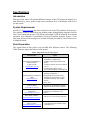
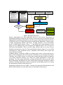
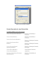
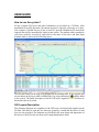
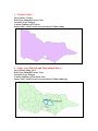
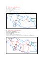
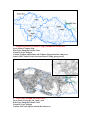
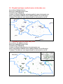
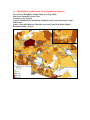
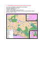
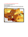
Specification and User Guide
Spatially Enabling Health Data in the Mitchell and
Murrindindi Shires
For
Lower Hume Primary Care Partnership
July-November 2008
Prepared by
Centre for SDIs and Land Administration
Department of Geomatics, The University of Melbourne
Specifications
Introduction
This part of the report will explain different features of the GIS system developed. It is
then followed by a user guide to help users in different level of familiarity with GIS to
use the system.
System Requirements
ArcGIS 9.2 (www.esri.com) has been selected as the main GIS platform of the project.
The software could be installed on any medium range desktop/laptop computer (such as
Intel Core2) and needs at least 1 GB of Ram and around 50 GB of hard disk for a smooth
operation. Also, MapInfo 8 (particularly Universal Translator function, Figure 2.) has
been used for data conversion process as most GIS data provided by Land Victoria were
in MapInfo format.
Data Preparation
The required data in this project was provided from different sources. The following
Table illustrates major data sources in the project.
Table1. Major data sources in the project
Data Provider
Data
Department of Sustainability
and Environment
(Land Victoria)
(www.land.vic.gov.au)
Australian Bureau of Statistics
(ABS)
(www.abs.gov.au)
Department of Human Services
Victoria (DHS)
(www.dhs.vic.gov.au)
Victorian Government Health
Information
(www.health.vic.gov.au)
- VicMap Property (Parcel and Property
Boundaries, Cadastre map)
- VicMap Transportation (Roads and
Rails)
- VicMap Localities (Local Government
Areas)
- VicMap Hydro (Rivers, Lakes, …)
- Post codes boundaries in the study area
- Mesh Blocks (Land use, No of
dwellings, Population …)
- Demographic and Socioeconomic
Information extracted from Census
2006 data including: Age, Gender,
Income …
- Quick Stats
- Regional Victorian Public Hospitals
- Regional Victorian Private Hospitals
- Directory of services in the study area
- The Home & Community Care
(HACC)
Better Heath Channel
(www.betterhealth.vic.gov.au)
- Directory of services in the study area
Mitchell and Murrindindi
Shires websites
(www.Mitchellshire.vic.gov.au)
(www.Murrindindi.vic.gov.au)
- General Information about the shires,
boundaries, etc.
Land Victoria
- VicMap Property (Parcel and
Property Boundaries,
Cadastre map)
- VicMap Transportation
(Roads and Rails)
- VicMap Localities (Local
Government Areas)
- VicMap Hydro (Rivers,
Lakes, …)
- Post codes boundaries in the
study area
Australian Bureau
of Statistics
Department of
Human Services
- Mesh Blocks in Study Area
(Land use, No of
dwellings, Population …)
- Demographic and
Socioeconomic
Information extracted
from Census 2006 data
including: Age, Gender,
Income …
- Quick Stats
Victorian Government
Health Information
Better Heath
Channel
Descriptive Data
- Directory of services in the study area
- The Home & Community Care
Conversion/Mapping/Geo-coding
Data Format
Check
No
Conversion to
ESRI Shape file
Maps
Yes
GIS Platform
(ESRI ArcGIS 9.2)
Spatial/Non
Spatial Analysis
Reports
Kml /Kmz
(Google Earth)
Figure1. Data preparation process
Figure1. demonstrates the data preparation process in the project. Department of
Sustainability and Environment (Land Victoria) was the main source of infrastructure and
administration boundaries information in the GIS system. Spatial information in the form
of GIS layers such as VicMap Property (Parcel and Property Boundaries, Cadastre map),
VicMap Transportation (Roads and Rails), VicMap Localities (Local Government
Areas), VicMap Hydro (Rivers, Lakes, …), and finally Post codes boundaries in the
study area were obtained from Land Victoria in the MapInfo format. The conversion of
GIS layers from MapInfo (.Tab) to ArcGIS (.Shp) could be done in two ways, first in
MapInfo environment by using The Universal Translator feature (Figure 2.) or in ArcGIS
environment by using extensions such as TabReader which allows direct import and
using Tab files in ArcGIS.
Australian Bureau of Statistics (ABS) was another major source of data in the project.
Most of the Demographic and Socioeconomic information were extracted from Census
2006 data. Age, Gender, Income, etc are the most common data that could be available at
ccd (census collection districts) level. Each ccd contain information of about 200
dwellings. The other major information available through ABS website was the Mesh
Block information. Mesh Blocks are more detailed units for data and each Block contains
around 50 dwellings information. Land use, population and dwelling numbers are among
the information provided in mesh block level.
Department of Human Services (DHS), Victorian Government Health Information and
Better Health Channel were also other sources of information in this project.
Figure2. Universal Translator in MapInfo
Product Description for Land Victoria Data
CUSTODIANSHIP OF EACH SET OF DATA
Victorian Township and Parish Boundaries -
Department of Sustainability &
Environment
Victorian Locality Boundaries –
Department of Sustainability &
Environment
Victorian Local Government Boundaries –
Department of Planning and Community
Development
Victorian Local Government Ward
Boundaries –
Department of Planning and Community
Development
Victorian Government Regional
Departmental Boundaries –
Department of Planning and Community
Development
Victorian Electoral Boundaries –
Victorian Electoral Commission
Victorian Postcode Boundaries –
Australia Post
Department of Sustainability & Environment
Regional Boundaries -
Department of Sustainability and
Environment
By arrangement, the Custodians have determined that the above datasets will be
maintained by:
Spatial Information Infrastructure
Department of Sustainability and Environment
Level 13 Marland House
570 Bourke Street
MELBOURNE VIC 3000
- Jurisdiction
State of Victoria, Australia
- Description
Vicmap Admin comprises several individual datasets. Each is topologically structured
and models all designated and gazetted boundaries across the whole of Victoria.
•
Geographic extent
Vicmap Admin content covers the entire state of Victoria.
•
Content
The Vicmap Admin product records administrative boundaries as defined by the
Custodian. These attributes are detailed in the detailed Product Descriptions of the
individual dataset.
•
Structure
The Vicmap Admin spatial data set consists of a series of lines and polygons. The
lines depict administrative boundaries, which in turn, define a state-wide coverage
of contiguous non-overlapping polygons. In combination these polygons represent
the entire administration area of Victoria. Point data will not be included in the
present structure of the Vicmap Admin data set.
•
Reference systems
The base reference system for Vicmap Admin is GDA94: Geographical
(latitude/longitude). Other reference systems supported include:
• AMG66: Australian Map Grid (cartesian coordinates); and
• AGD66: Geographicals
• MGA94: Map Grid of Australia (cartesian coordinates).
•
Features of note
Vicmap Admin is intended to accurately record the location of the boundaries
represented. This means that changes occur on an irregular basis in response to
administrative boundary reviews conducted by the respective Custodian. Versions
of the information product will be clearly identifiable. Features of note include:
• Unique Feature Identification (each feature uniquely identified for change
management).
• Updates provided as whole file replacement.
• Temporal Data Management (features date stamped - data retired, effective date,
no data is deleted).
•
Related data sets
Vicmap Admin forms part of the State of Victoria’s Framework Information spatial
data infrastructure. Vertical alignment will be primarily based on associated
Vicmap products such as Vicmap Property for cadastral boundaries and Vicmap
Transport for road centreline and railway alignment detail.
•
Reference tables
Reference tables are used in the production and maintenance of Vicmap Admin.
These reference tables are held by Department of Sustainability and Environment in
an Oracle database and are available in most database, spreadsheet and delimited
formats. Copies are available on Department of Sustainability and Environment’s
GIS web site: www.land.vic.gov.au. Copies may also be obtained directly from
Department of Sustainability and Environment.
- Production and/or Acquisition Methods
Vicmap Admin clearly defines administrative boundaries in terms of their underlying
spatial features, such as property boundaries, railway lines, creek banks and road
centrelines.
Vicmap Admin is a component part of the Vicmap suite of Victoria-wide Framework
Information products. Vertical alignment with underlying property or transport data is
a priority and where ever possible has been achieved. Variation or non-alignment
occurs due to data origins, and/or the differing nature of content, and/or the
requirements and constraints at the time of construction of the datasets. For example,
the origin of much topographic data is the State’s 1:25,000 standard mapping program
and the origin of much cadastral data varies from direct input survey co-ordinates to
1:25,000 property/parcel mapping. Other issues relate to temporal factors. For
example, the topographic representation of a stream bank in Vicmap Hydro will be
what exists today; the cadastral representation of the same stream bank in Vicmap
Property will be what was surveyed at the time of alienation. Whilst observation has
shown that the alignment of the same or similar features across these data sets is
extraordinarily good, scale variation, temporal issues and feature definition will result
in variance in many cases. Whilst full vertical alignment is being targeted by
Department of Sustainability and Environment, these manifold issues will delay its
final achievement. Whilst these alignment issues are being attended to, the difficulty
to Department of Sustainability and Environment and Vicmap users is the need for
two versions of the same Vicmap Admin data. One version will be aligned to the
cadastre (Vicmap Property) and the other aligned to topographic features (Vicmap
Transport, Vicmap Hydro, etc). In many cases, the two versions will be the same, or
similar, however there may be differences due to those fundamental variations
highlighted above.
KEY SOURCE OF INPUT DATA
Each respective Custodian determines the true and correct definition of administrative
boundaries. This information is interpreted as part of the maintenance regime
undertaken by Department of Sustainability and Environment. The Custodian
subsequently validates its final representation in Vicmap Admin.
- Currency & Status
Administrative definition is determined by the Custodian. On receipt of any
realignment advice from the custodian, Department of Sustainability and Environment
will immediately forward such information to its data maintainers for inclusion into
Vicmap Admin.
- Spatial Accuracy
The accuracy of this data set has not been specifically determined. Where it aligns
with underlying elements in related Vicmap products such as Vicmap Property or
Vicmap Transport, its accuracy will be that of the underlying feature. For information
regarding these products, please refer to their product specifications. Copies are
available on Department of Sustainability and Environment’s GIS web site at
www.land.vic.gov.au.
- Feature and Attribute Accuracy
For this product, feature and attribute accuracy is a measure of the degree to which the
features and attribute values of spatial objects agree with the information on the source
material. The maximum allowable error in attribute accuracy is 1%.
- Completeness
The reliability figures indicating completeness of content between the dataset and the
source material for administrative definition is 99%.
- Logical Consistency
Logical consistency is a measure of the degree to which data complies with the
technical specification. The maximum allowable error in logical consistency is 1% for
maintenance activity. The test procedures are a mixture of software scripts and onscreen, visual checks.
METADATA
Metadata at Anzlic Page 0 level has been created and is included in the Victorian
Spatial Data Directory (VSDD). Page 0 Metadata may be viewed via the government
Land Information website, Land Channel, at http://www.land.vic.gov.au/.
Product Description for ABS Data (Mesh Blocks)
DATASET CUSTODIAN
- Title: Mesh Blocks (2006) Digital Boundaries, Australia (ABS Cat. No. 1209.0.55.002)
- Custodian :ABS Geography Section: [email protected]
DESCRIPTION
- Abstract:
These digital boundaries represent Mesh Blocks which are the smallest geographical
unit for which ABS data will be output. Mesh Blocks will be integrated into the ABS's
statistical geography for the 2011 Census. These Mesh Blocks are currently
experimental and contain basic 2006 Census data (total usual resident population and
dwelling count). Mesh Blocks are identified with a unique 11 digit code.
- Geographic Extent Name
Geographic Australia; including the external territories of Cocos (Keeling) Islands &
Christmas Island but excluding all other external territories.
- Data Currency
Beginning date: November 2004
End date: Contains updates in underlying topographic data up to August 2007.
- Data Status
Progress: On-going
Maintenance and Update Frequency: On-going
DATA ACCESS
- Stored Data Format
Digital MapInfo files
- Available Format Type
MapInfo mid/mif and ESRI Shapefiles
- Access Constraints
Copyright Commonwealth of Australia administered by the ABS.
DATA QUALITY
- Lineage
Mesh Blocks boundaries were created using various sources including the PSMA
digital topographic datasets and ABS SLA boundaries, zoning information from state
planning agencies and imagery.
- Positional Accuracy
The PSMA topographic database to which boundaries are aligned was captured at
scales which vary from 1:4,000 in urban areas to 1:250,000 in remote areas.
- Attribute Accuracy
Mesh Block codes & labels are fully validated.
- Logical Consistency
Spatial units are closed polygons. These data include attribute records without spatial
objects for administrative purposes.
- Completeness
The 2006 Mesh Blocks are represented in their entirety.
CO-ORDINATE SYSTEMS
- Datum
Geocentric Datum of Australia 1994 (GDA94)
- Projection
Geographical (ie latitudes and longitudes)
- Metadata Date
February 2008
- Additional Metadata
Reference: Information Paper: Draft Mesh Blocks, Australia (Reissue), 2005 (ABS
Cat. No. 1209.0.55.001)
ATTRIBUTE INFORMATION (Mesh Blocks)
FILE ATTRIBUTES
File Type
Mesh Block
(MB)
Field Name MapInfo Files Field Name
Shapefiles
MB_Code
MB_Code
Type
Comments
Float
11 digit Mesh Block code
MB_Category
Category
Total_UR_Population_2006 TURPOP2006
Character Landuse category
Float
Total Usual Resident
population
Float
Total dwellings
Character Imputation rate quality
indicator
Date
Records change date for the
MB
Total_Dwellings_2006
MB_Imputation_Rate
TDWELL2006
Imput_Rate
MB_Date_Modified
Date_Mod
MB_Code:An 11 digit field with the first digit being the state code.
The State/Territories are identified by unique one digit codes as follows:
1 = New South Wales
2 = Victoria
3 = Queensland
4 = South Australia
5 = Western Australia
6 = Tasmania
7 = Northern Territory
8 = Australian Capital Territory
9 = Other Territories
Note that there are special non spatial codes for each state (see "Non spatial Mesh
Blocks" below)
MB_Category: The Mesh Block Category (MB_Category) attribute is a field based on
planning/zoning scheme data provided by each state/territory. The ABS consolidated the
files for each state/territory then mapped the land uses to a highly generalised set of land
uses. The ABS acknowledges that this planning data represents a planned land use and
there will be many cases where actual land use is quite different to the planned land use.
The Mesh Block category shown in the Mesh Blocks boundary dataset is not designed to
provide a definitive land use mapping, it is purely an indicator of the main planned land
use for a Mesh Block.
Valid MB_Category values are; Residential, Commercial, Industrial, Agricultural,
Parkland, Educational, Hospital/Medical, Transport, Water, Shipping, Nousualresidence
and Other.
Total_UR_Population_2006: This is the count of people where they usually live, which
may or may not be where they were on census night. This data is coded from the address
supplied to the question "Where does the person usually live?". Please see the entry for
Place of Usual Residence in 2901.0 - Census Dictionary, 2006 for more information.
Total_Dwellings_2006: A dwelling is a structure which is intended to have people live
in it, and which is habitable on Census Night. Some examples of dwellings are houses,
motels, flats, caravans, prisons, tents, humpies and houseboats. All occupied dwellings
are counted in the Census. Unoccupied private dwellings are also counted with the
exception of unoccupied dwellings in caravan parks, marinas and manufactured home
estates. Please see the entry for Dwellings in 2901.0 - Census Dictionary, 2006 for more
information.
MB_Imputation rates: Some Census data were not able to be attributed to a Mesh
Block. The Mesh Block code for this uncoded data was therefore imputed using
information on dwelling structure and the Collection District. The MB_Imputation_Rate
field details the percentage of the dwellings attributed to each Mesh Block that were
imputed. The ranges are;
MB_Imputation_rate Range
No Imputation 0
Low Imputation greater than 0% to less than 10%
Medium Imputation greater than 10% to less than 50%
High Imputation greater than 50% to less than 100%
The aim is to provide users with a broad indication of the quality of the coding associated
with each Mesh Block.
MB_Date_Modified: This field is used to record when the most recent change was made
to the Mesh Block. It can help relate the Mesh Block to the date of the topographic data
used for its creation.
USER GUIDE
How to use the system?
All the required GIS layers and other information are provided in a CD-Rom. After
installation of ArcGIS, the entire CD contents need to be copied to a directory on C drive:
(For example C:\Health Project). Then, in ArcGIS, open the Health.mxd file and all the
required data will be automatically loaded to the system. The attribute tables attached to
each layer could be accessed by right-click to the name of the layer and then Open
Attribute table as shown in the following figure:
The selected features in the map are highlighted in the attribute table. If the required data
are not shown on the layers table (left hand side), by using add bottom,
could be added
to the system. The detail description of all the GIS layers supplied on the CD-Rom are
discussed in the next section.
GIS Layers Description
The following diagrams are snapshots of the GIS layers developed and supplied on the
Cd-Rom. The name of each date set, data type, geometry, content and the source of each
layer are also provided. The diagrams are provided in the same shape and appearance of
the layers in ArcGIS so the user may easily comprehend and use them.
1 - Victoria (State)
Layer Name: Victoria
Data Type: Shapefile Feature Class
Geometry Type: Polygon
Content: Boundary of Victoria
Source: DSE; Land Victoria (extracted from VicMap-admin)
2 - Study Area (Mitchell and Murrindindi Shires)
Layer Name: Study_Area
Data Type: Shapefile Feature Class
Geometry Type: Polygon
Content: Boundary of the Study Area
Source: DSE; Land Victoria (extracted from VicMap-admin-lga)
3 – Rail roads in the study area
Layer Name: Rail_Road
Data Type: Shapefile Feature Class
Geometry Type: Line
Content: Rail roads in the study area
Source: DSE; Land Victoria (extracted from VicMap_trans_rail_polyline)
4 – Major roads in the study area
Layer Name: Major_Roads
Data Type: Shapefile Feature Class
Geometry Type: Line
Content: Major roads in the study area
Source: DSE; Land Victoria (extracted from VicMap_trans_roads_polyline)
5 – Towns in the study area and Towns nearby study area
Layer Name: Towns_in_Study_Area/Towns Nearby_Study_Area
Data Type: Shapefile Feature Class
Geometry Type: Multipoint
Content: Towns inside and nearby the study area
Source: DSE; Land Victoria (extracted from VicMap_admin)
6 – Major Rivers and Lakes around the study area
Layer Name: Major Rivers/Lakes
Data Type: Shapefile Feature Class
Geometry Type: Line/Polygon
Content: Major Rivers and Lakes around the study area
Source: DSE; Land Victoria (extracted from VicMap_Hydro)
7 – Property parcels (Cadastre Map) around the study area
Layer Name: Cadastre Map
Data Type: Shapefile Feature Class
Geometry Type: Polygon
Content: Property Boundaries and Cadastre Map around the study area
Source: DSE; Land Victoria (extracted from VicMap_prop_parcel)
8 – Post codes around the study area
Layer Name: PostCodes_In _Study_Area
Data Type: Shapefile Feature Class
Geometry Type: Polygon
Content: Post code regions around the study area
Source: DSE; Land Victoria (extracted from VicMap_Admin)
9 – Property addresses in the study area
Layer Name: Addresses_In _Study_Area
Data Type: Shapefile Feature Class
Geometry Type: MultiPoint
Content: Addresses for all properties in the study area
Source: DSE; Land Victoria (extracted from VicMap -address08 - point)
10 – Hospitals and major medical centres in the study area
Layer Name: Medical Centres
Data Type: Shapefile Feature Class
Geometry Type: MultiPoint
Content: Location of Hospitals and major medical centres in the study area
Source: Department of Human Sevices (DHS); Human Services Directory
Comment: The addresses were imported and Geo-referenced in ArcGIS
11 – All medical services in the study area
Layer Name: All_Medical_Services
Data Type: Shapefile Feature Class
Geometry Type: MultiPoint
Content: Location of all medical services in the study area
Source: Department of Human Sevices (DHS); Human Services Directory
Comment: The addresses were imported and Geo-referenced in ArcGIS
12 –Major Bus Routs in the study area
Layer Name: Bus_Routs
Data Type: Shapefile Feature Class
Geometry Type: Line
Content: Major Bus services in the study area
Source: Department of Infrastructures (DOI)
13 – Mesh Blocks around study area (Population Analysis)
Layer Name: Mesh Block around Study Area (Pop -2006)
Data Type: Shapefile Feature Class
Geometry Type: Polygon
Content: Distribution of Population around the study area based on the Census
2006 results
Source: Australian Bureau of Statistics (extracted from Mesh Blocks Digital
Boundaries 2006, Victoria)
14 – Mesh Blocks around study area (Land-use Analysis)
Layer Name: Mesh Block around Study Area (Category)
Data Type: Shapefile Feature Class
Geometry Type: Polygon
Content: Land_use map around the study area
Source: Australian Bureau of Statistics (extracted from Mesh Blocks Digital
Boundaries 2006, Victoria)
15 – Economic analysis (household income Analysis)
Layer Name: Household_Income($ per week)
Data Type: Shapefile Feature Class
Geometry Type: Polygon
Content: Household income around the study area (based on Census 2006 results)
Source: Australian Bureau of Statistics (extracted from Basic Community Profiles
2006, Victoria)
16 – Social analysis (Population Density)
Layer Name: Population Density
Data Type: Shapefile Feature Class
Geometry Type: Polygon
Content: Population Density around the study area (based on Census 2006 results)
Source: Australian Bureau of Statistics (extracted from Basic Community Profiles
2006, Victoria)
17 – Social analysis (Population over 65 years old)
Layer Name: Population Age 65+
Data Type: Shapefile Feature Class
Geometry Type: Polygon
Content: Distribution of Population (Age 65+) around the study area (based on
Census 2006 results)
Source: Australian Bureau of Statistics (extracted from Basic Community Profiles
2006, Victoria)
18 – Social analysis (Population 5-14 years old)
Layer Name: Population Age 5-14
Data Type: Shapefile Feature Class
Geometry Type: Polygon
Content: Distribution of Population (Age 5-14) around the study area (based on
Census 2006 results)
Source: Australian Bureau of Statistics (extracted from Basic Community Profiles
2006, Victoria)