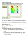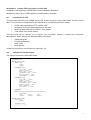
1
Data Interrogation and Visualisation Environment
User Manual for DIVE Version 3.3.3
September 2015
Gary Carroll & Uwe Rosebrock
Sections from DIVE 2.0 User Manual by Irshad Nainar
Important Notice
©
Copyright
Commonwealth
(‘CSIRO’) Australia 2011
Scientific
and
Industrial
Research
Organisation
All rights are reserved and no part of this publication covered by copyright may be reproduced or copied
in any form or by any means except with the written permission of CSIRO.
The results and analyses contained in this User Manual are based on a number of technical,
circumstantial or otherwise specified assumptions and parameters. The user must make its own
assessment of the suitability for its use of the information or material contained in or generated from the
User Manual. To the extent permitted by law, CSIRO excludes all liability to any party for expenses,
losses, damages and costs arising directly or indirectly from using this User Manual.
Table of Contents
1. INTRODUCTION............................................................................................................................................... 1 1.1. 1.2. 1.3. 1.4. 1.5. Motivation ..................................................................................................................................................... 1 Features .......................................................................................................................................................... 1 Supported Data Streams ................................................................................................................................ 1 Website .......................................................................................................................................................... 2 User Manual .................................................................................................................................................. 2 2. REQUIREMENTS .............................................................................................................................................. 2 2.1. Memory ......................................................................................................................................................... 2 2.2. Software ......................................................................................................................................................... 2 3. INSTALLING AND USING DIVE ................................................................................................................... 2 3.1. Windows ........................................................................................................................................................ 2 3.2. Mac OSX ....................................................................................................................................................... 3 3.3. Linux .............................................................................................................................................................. 3 4. DIVE CONTACTS ............................................................................................................................................. 3 5. OVERVIEW OF DIVE ...................................................................................................................................... 3 5.1. Dataset Selection ........................................................................................................................................... 3 5.1.1. Dataset Explorer Panel ............................................................................................................. 4 5.1.2. Variable Selector Panel ............................................................................................................ 4 5.1.3. Selected Data Panel .................................................................................................................. 5 6. VISUALISING DATASETS AND VARIABLES ............................................................................................ 5 6.1. Overview of DIVE Functions ........................................................................................................................ 6 6.1.1. Variables Panel Functions ........................................................................................................ 6 6.1.2. Map Panel Functions ................................................................................................................ 7 6.2. Edit Properties ............................................................................................................................................... 7 6.2.1. Plot settings .............................................................................................................................. 8 6.2.2. Correct for rotation................................................................................................................. 14 6.2.3. Temporal settings ................................................................................................................... 14 6.2.4. Point data settings .................................................................................................................. 14 6.3. Time Slider .................................................................................................................................................. 16 6.4. Height Slider ................................................................................................................................................ 16 6.5. Selecting Sample Points .............................................................................................................................. 16 6.5.1. Selecting Multiple Sample Points .......................................................................................... 17 6.6. Profile Plots ................................................................................................................................................. 19 6.7. Time Series Plots ......................................................................................................................................... 20 6.8. Exporting Images and Movies ..................................................................................................................... 21 6.8.1. Making Images ....................................................................................................................... 22 6.8.2. Making Movies or Animations .............................................................................................. 22 6.9. Data Point Attributes ................................................................................................................................... 22 6.9.1. Biological Point Data ............................................................................................................. 22 6.9.2. Gridded Data Sets .................................................................................................................. 23 6.10. Data Source Attributes............................................................................................................................... 24 6.11. Section Plots .............................................................................................................................................. 24 6.11.1. Gridded Data Section Plots .................................................................................................. 24 6.11.2. Point Data Section Plots ....................................................................................................... 26 6.12. Time Zones ................................................................................................................................................ 26 6.13. Changing order of variables ...................................................................................................................... 27 6.14. Displaying a Plot in a Separate Window ................................................................................................... 28 6.15. Changing Your View of a Plot .................................................................................................................. 28 6.15.1. Manually setting axis properties .......................................................................................... 29 6.16. Changing the format of cursor latitude and longitude ............................................................................... 30 7. SEDIMENT PLOTS ......................................................................................................................................... 31 8. NCML FILES .................................................................................................................................................... 32 9. MNC FILES – MULTIPLE NETCDF FILES ............................................................................................... 32 APPENDIX A. COLUMN FILE CONVENTION, VERSION 2.02 ................................................................... 1 A.1. Introduction to CFF ...................................................................................................................................... 1 A.2. Column File Format Layout ......................................................................................................................... 1 A.3. Features ......................................................................................................................................................... 2 A.4. Description .................................................................................................................................................... 2 A.4.1. BLOCK ...................................................................................................................................................... 2 A.4.2. INFO .......................................................................................................................................................... 2 A.4.3. VARIABLE ............................................................................................................................................... 2 A.4.4. DATA ........................................................................................................................................................ 3 A.4.5. ATTRIBUTES ........................................................................................................................................... 3 A.5. Column File Format For “Profile” Data ....................................................................................................... 3 A.6. Column File Format For “Underway”Data .................................................................................................. 4 A.7. Column File Format For “Mooring”Data ..................................................................................................... 5 APPENDIX B. SRFME REPOSITORY ............................................................................................................... 1 B.1. SRFME Repository Explorer ........................................................................................................................ 1 APPENDIX C. LICENCE CONDITIONS ........................................................................................................... 1 APPENDIX D. THIRD-PARTY SOFTWARE COMPONENT LICENCES ................................................... 2 D.1. D.2. D.3. D.4. D.5. D.6. D.7. D.8. D.9. D.10. Apache Software Foundation ....................................................................................................................... 2 Flagstone Software ....................................................................................................................................... 4 Simple Logging Facade for Java Organisation ............................................................................................. 4 The JDOM Project ........................................................................................................................................ 5 Java.net ......................................................................................................................................................... 5 OPeNDAP..................................................................................................................................................... 9 University Corporation for Atmospheric Research/Unidata ........................................................................ 9 The Open Source Geospatial Foundation ................................................................................................... 10 Coverity ...................................................................................................................................................... 10 Joda Organization ..................................................................................................................................... 10 1.
Introduction
This document is a user manual for DIVE, the Data Interrogation and Visualisation Environment. It
explains the capabilities and use of DIVE.
DIVE is a graphical application to interactively explore and visualise marine datasets. It provides users
with the ability to compare datasets in space and time.
DIVE was initially developed under the Strategic Research Fund for the Marine Environment (SRFME)
and is based on prior work within the CSIRO Division of Marine & Atmospheric Research (CMAR).
Development has continued under funding from the Western Australian Marine Science Institute
(WAMSI).
CSIRO makes DIVE available under the licence terms which can be viewed in Appendix C. These terms
are based on the BSD licence. By downloading and using DIVE you acknowledge you have read and
accept the terms in this licence.
DIVE uses a number of third party libraries. These libraries are installed when DIVE is installed. CSIRO
distributes these libraries under the same terms on which these libraries were made available to CSIRO.
The licence terms for these libraries can be viewed in Appendix D of the DIVE User Manual. Licences for
the third party libraries are also available within DIVE under the Help->Third Party Library Licences
menu.
By downloading DIVE you acknowledge you have read and accept the library licence terms.
Please note that DIVE was developed for research purposes only. As such, CSIRO makes no
representations express or implied as to:
•
The accuracy of DIVE or the absence of defects or errors in DIVE; or
•
The non-infringement by DIVE of intellectual property rights of third parties.
CSIRO is not obliged to provide any support services for DIVE including providing any advice or
answering any questions about the use or performance of DIVE.
1.1. Motivation
Environmental research involves the compilation of large numerical datasets that are accumulated
through field programs, remote sensing and numerical model runs. Not only are these datasets large in
volume but they are also diverse. They range from 1-dimensional point data (e.g. species biomass) to 4dimensional time-varying volumetric datasets (e.g. model output).
These diverse datasets are not easily understandable without the aid of visualisation tools. An interactive
graphical tool with the capability to link to data repositories is the most effective means of delivery the
data to the wider scientific community and to CSIRO’s partners and collaborators.
1.2. Features
DIVE provides the user with the ability to visualise datasets and compare them by overlaying data from
multiple sources. DIVE supports the display of spatial maps, time-series plots, vertical profiles and crosssection plots. The spatial data is represented as coloured maps, contoured plots, vector maps or as
habitat maps.
DIVE can explore and visualise datasets stored on your own computer (or network-connected file
system) as well those in an established data repository.
1.3. Supported Data Streams
DIVE supports the following types for data-streams:
•
Model outputs
o
Hydrodynamic models
o
Biogeochemical models
1
•
•
•
•
•
•
o
Wave models
o
Atmospheric models
Climatology data
Remote sensing data
o
AVHRR SST data
o
SeaWIFS Chlorophyll data
Benthic habitat data
Underway time-series and glider data
Temperature/salinity profile data (CTD casts)
Data measured by moored instruments
These data-streams may be stored in different file formats. DIVE support the following file formats:
•
•
•
NetCDF files that conform to commonly used formats within the oceanographic community
such as COARDS, CF-1.0, etc.
ASCII files conforming to the CMAR Column File Format (CFF). This format was designed
specifically to capture observational datasets such as vertical profiles and time-series.
ASCII files conforming to the CMAR Shape File Format (SFF). This format was designed to
flexibly define geometric shapes.
1.4. Website
The website for DIVE is http://software.cmar.csiro.au
1.5. User Manual
The user manual, which you are now reading, is available within DIVE under the Help menu. On
Windows it is also available via the Programs ➞ DIVE menu.
2.
Requirements
2.1. Memory
512 MB or more depending on size of datasets being explored.
2.2. Software
Java Runtime Environment (JRE) 1.7 or above. DIVE will run on any platform that supports Java, such
as Microsoft Windows variants, Linux, Solaris and MacOSX. The JRE is not included with the DIVE
installer. This can be downloaded from http://java.com/en/download.
3.
Installing and Using DIVE
A DIVE installer is available for Windows operating systems (XP and above), Mac OSX and Linux. The
same installer is used for Windows, Mac and Linux operating systems. There are different versions of
the DIVE installer dependent upon the organisation that DIVE is being deployed in. The first panel of the
DIVE installer will say which organisation the installer is intended for. If your DIVE installer is not
appropriate then contact someone listed in section 4.
After installing DIVE, delete the installation program if you wish. It is not required to run DIVE.
3.1. Windows
By default, DIVE will be installed into C:\Program Files\DIVE but you may change this during the
installation process.
2
The normal Windows start menu shortcuts will be created, and DIVE can be run using Programs menu
accessed via the Start menu button.
3.2. Mac OSX
DIVE will be installed by default into the /Applications/DIVE.app directory.
Run DIVE from the Applications folder, or via the Dock’s Applications shortcut.
3.3. Linux
DIVE will be installed into your home directory, for example /home/fred/DIVE.
Run DIVE by using the script ~/DIVE/bin/dive.
4.
Dive Contacts
Gary Carroll, CSIRO Oceans and Atmosphere - Hobart, [email protected] (03) 6232 5488
Uwe Rosebrock, CSIRO Oceans and Atmosphere – Hobart, [email protected] (03) 6232 5181
5.
Overview of DIVE
The DIVE application consists of a dataset selection component and a data visualisation component.
The Data Selection dialog allows you to select the variables of interest. These variables can be selected
from multiple datasets. Once the variables of interest are selected and submitted, they are plotted on the
data visualisation window.
5.1. Dataset Selection
When DIVE is first run you are presented with a window for selecting datasets. This is known as the
Data Selection dialog which is shown in Figure 1.
Figure 1, Dataset Selection Dialog using File Explorer
On the left hand side you will see a tab “File Explorer” for directly opening files from your computer.
Depending on how DIVE is configured, you may also have access to a data repository and there will be
“Repository Explorer” tab for this purpose.
3
Regardless of whether you are using the file or repository explorer, the process of selecting datasets and
variables to display is basically the same. Many files can be open concurrently and they are added to the
Dataset Explorer Panel as they are opened.
The description here focuses on using the “File Explorer” tab. The Variable Selector and Selected Data
Panels in both the File a Repository Explorers function in the same manner. Further details on using a
repository explorer are in Appendix B.
The File Explorer interface is used to select a file (which must be in a format supported by DIVE) from
the local or from a network accessible file system. The open file
button invokes a standard open file
dialog that can be used to load the file.
Data available on an OPeNDAP (DODS) server is accessed via the OPeNDAP server
button which
invokes a dialog to specify the data’s URL. When viewing a THREDDS catalogue service data set you
should copy the URL given next to the OPENDAP heading into the DIVE dialog as shown in Figure 2.
OPenDAP URLs prefixed with dods:// or http:// are acceptable.
Figure 2, OPenDAP / DODS open file dialog
In special cases the same meta-data is shared in separate files, each for a different record time. For
these cases the entire directory of files is treated as one data source, and these can be opened in one
action. This only applies to NetCDF files and the header geometry must be exactly the same. To access
files in this way the
button must be used.
The Data Selection Dialog consists of three panels.
5.1.1.
Dataset Explorer Panel
This is the left-most panel. This displays the selected data files on your computer or network-connected
file system.
5.1.2.
Variable Selector Panel
This is the middle panel. This panel displays the variables present in the dataset selected from the
Dataset Explorer Panel. On selecting the dataset, the variables in the datasets are displayed in this
panel.
When you select, by clicking on, a variable from the Variable Selector Panel, buttons will appear to the
right of the Variable Selector Panel. The buttons will vary depending upon the nature of the variable
selected. You can select the variables to be displayed as follows:
Display variable as a colour map
Display variable as a contour map
Display variable as a vector map
Toggle to display sediment variables. See section 6.16.
Clicking on one of these buttons will add the variable to the Selected Data Panel, and the variable will be
ready to visualise.
4
5.1.3.
Selected Data Panel
This is the right-hand panel. This panel displays the variables selected for visualisation.
Click “ok” to hide the Data Selection Dialog and to visualise the chosen datasets.
Datasets or individual variables can be removed from the Selected Data Panel by using the
this variable has already been plotted by DIVE it will be removed from all plots.
6.
button. If
Visualising Datasets and Variables
The data selected on the data selection dialog is plotted on the main application window. The variable(s)
are plotted on the drawing region in the main application window. The drawing region contains a
geographical map view, vertical profile view and time-series view. The selected variable is plotted onto
one or more of these panels based on the type of data stream it represents. Once the data is plotted, a
variety of operations can be performed on the data. These are described below.
One of the core features in DIVE is its capability to compare datasets in space and time. It allows
variables from disparate data sources to be overlaid. Variables can be quickly overlaid by adding them
via the Data Selection Dialog, and quickly removed or hidden as required.
5
6.1. Overview of DIVE Functions
The variables from the datasets chosen are displayed in a single window as shown in Figure 3.
Figure 3, DIVE Visualisation Window
The variables panel (left hand side) and the main map window will always be visible. However, other
panels such as the time series and profile panels will only be visible if you have chosen to display these
and if the variable being displayed is suitable.
As the cursor is moved across the map window the position of the cursor is displayed on the bottom left
of the DIVE window. For the map, this will be the latitude and longitude; for the time series this will be the
time; for the profile plot this will be the height.
The variables’ values at the cursor location are displayed on the bottom left hand side of the DIVE
window under the variables’ names.
6.1.1.
Variables Panel Functions
These buttons are at the top left of the DIVE window. They relate to variables and datasets. Select (in
the left-side panel) the variable you wish to operate on, and chose one of the following.
Add variable. This brings back the data selection dialog. Use this to visualise additional
variables and to open additional datasets.
Remove variable. Removes the variable from the selected variables panel and all DIVE plot
panels.
Edit Properties. Allows you to set the display properties of the selected variable. There are
many options - See section 6.2.
Fit map to variable. Resizes and re-positions the map panel to show the selected variable at
the maximum size possible.
6
6.1.2.
Map Panel Functions
These buttons that appear at the top of the DIVE window are used to control DIVE. They allow you to
print, export images and animations, examine metadata and control the appearance of DIVE’s plot
panels.
Print tool. This invokes the printer dialog for printing the plot regions that are displayed.
Print Preview. The Print Preview tool creates a preview of the plot regions that are displayed.
From here you can change the page setup and print.
The Select Tool. This is used for sampling variables in space and time. See section 6.5.
Move origin. This pans the map. Select this button, and then you can drag over the map to
change what is shown.
Zoom in. Select this button, then click on the location on the map you wish to zoom into. You
can also use this tool to sweep, or draw a rectangle around, the area of map you wish to
view.
Zoom out. Select this button, then click on the map. It will zoom out centred on the clicked-on
location.
Export Images and Movies. This is for exporting bitmap images and animations in a variety of
formats. See section 6.8.
Data Attributes. This is for displaying data attributes. This is used for the display of
information about datasets. See section 6.9.
Display Coastline. This is a toggle button. When selected will the coastline be drawn. When
not selected coastline will not be drawn and the land will not be shaded.
Shading of land. This is a toggle button. When selected the land will be filled with a solid
colour. This shading will hide atmospheric data over land.
Profile Plot. This is a toggle button. Hide/show the profile plot. The plot will only be displayed
if there is suitable data.
Time Series Plot. This is a toggle button. Hide/show the time series plot. The plot will only be
displayed if there is suitable data.
Section Plots. This creates cross-section plots for gridded data with a vertical (depth or
height) component. See section 6.10.
Time Zone. This allows you to view the data according to a chosen time zone. See section
6.12.
6.2. Edit Properties
Use this function to change the appearance of a plot. Select the variable, from the Variables Panel,
whose appearance you wish to change, then click on
. You will see a variety of options. There are
some common options for changing the visibility of plots and plot keys, and other options will appear or
not depending on the nature of the data and the plot.
The properties are divided into sections – which appear as tabs:
Figure 4, Property tabs
7
6.2.1.
Plot settings
The dialogs used within Plot settings will vary depending on the plot displayed.
Figure 5, Map plot type dialog
Figure 5 appears for gridded data sets. It allows you to choose between a colour, contour or arrow maps
(plots). To visualise a variable as both a colour map and with contours you will need to add the variable
twice, making one plot contour and the other a colour map.
Arrow maps are used to display scalar variables as vectors, which implies that the value represents an
angle of some sort. The unit for the value is tested has to be degrees or radians, or abbreviations of
these.
Figure 6, Colour image dialog
Figure 6 appears for colour plots. If auto scale is selected the lowest and highest values of the variable
will be used for the range of the colour table.
You can override these automatic settings by choosing your own lower and upper limits.
Base colour range on section plot only appears when a section plot is being viewed. If it is not selected,
the map plot’s colour range will be used to colour the section plot. If this option is selected, the colour
range of the section plot will be used to colour the map plot.
Auto scaling should be turned off when making animations. Otherwise each frame in the animation could
have a different colour representation for a given variable’s value from one frame to the next.
If draw cell borders is selected the map panel and cross-section panels will outline the cells in black as
shown in Figure 7.
Figure 7, Map panels with and without cells borders
8
Figure 8, Colour table dialog
Figure 8 appears for all colour plots. Use this to chose the colour scheme used for the plots.
Figure 9, Contours dialog
Figure 9 appears for contour plots. DIVE can auto-scale the contours used, or you can chose your own
contour levels.
If you wish to define your own contour intervals you will need to define the contour range and intervals.
There are several formats for doing this:
Lower limit:contour interval:upper limit: For example 15:0.5:18 will draw contours at 15, 15.5, 16,
16.5, 17, 17.5, 18.
A series of comma separated numbers: For example 15,16,18,21 will draw contours at 15,16,18 and
21.
A combination of the above separated by commas: 15:0.2:16, 19, 20 will draw contours at 15.0, 15.2,
15.4, 15.6, 15.8, 16, 19 and 20.
Figure 10, Vector properties dialog
Figure 10 appears for vector data. This dialog controls the size and number of arrows displaying the
vector field. “Arrow scale” controls the size of the vector arrows, and “Arrow density” controls the number
of arrows. You will need to experiment with these values to find a combination that suits your plot.
9
Figure 11, Vector Component dialog
Figure 9 appears for scalar variables when arrow maps has been selected. See section 6.2.2 for details
on “Correct for rotation”. “Inverse” rotates the displayed arrows by 180°. “Toggle Nautical/Cartesian” flips
between a nautical or Cartesian coordinates. By default a nautical orientation is assumed. Flipping to
Cartesian assumes that the value is given in a mathematical context.
Figure 12, Vector component dialog
The Vector component dialog show in Figure 12 defines what component of the vector is displayed, and
controls the appearance of the vectors.
“Magnitude” plots using the vector magnitude and direction as shown in Figure 13. The value of the
variable displayed while moving the cursor over the data is the magnitude of the variable.
“Direction” plots appear the same as “Magnitude” plots. However the value of the variable displayed
while moving the cursor over the data is the direction of the variable.
10
Figure 13, Magnitude vector plot
“East component” plots the east-west component of the vector as shown in Figure 14. The value of the
variable displayed while moving the cursor over the data in the eastern component of the vector.
Figure 14, East component vector plot
11
Figure 15, North component vector plot
“North component” plots the north-south component of the vector as shown in Figure 15. The value of
the variable displayed while moving the cursor over the data in the northern component of the vector.
See section 6.2.2 for details on “Correct for rotation”.
When selected, “Wind Flags” will:
•
draw the vectors using meteorological barbed wind symbols showing velocity in knots (one full
barb represents 10 knots). The barbs are on the end the wind is coming from. Figure 16 shows
wind from the north west. The same plot using the default vector arrows is shown in Figure 17.
•
cause the display of the vector’s velocity in the variable panel to be in knots.
Note that the legend appears only for the vector presentation.
12
Figure 16 - Barbed wind symbol chart
Figure 17 - Equivalent plot using vector arrows
13
Figure 18, Plot visibility dialog
Figure 18 appears for all plots. This dialog can be used to:
“Show the map”: Hides the map plot for this variable – without removing the variable. The time series,
profile and section plots are still shown.
“Show profile”: Show or hide the profile plot. Same function as the
button.
“Show time-series”: Show or hide the time-series plot. Same function as the
button.
“Show plot key”: Show or hide the colour scale bar as shown in Figure 3.
“Show profile axis: Show or hide the variable’s scale bar in the profile plot.
“Show time-series axis”: Show or hide the variable’s scale bar in the time-series plot.
6.2.2.
Correct for rotation
If the “Correct for rotation” check box is selected the vectors will be drawn offset by the rotation of the
grid. The rotation angle must be available in the data source. In some data sources that is not the case
and as a consequence the selection has no effect. This is rarely used, but is important in a case where
the vectors were defined in a Cartesian grid and this grid is rotated in a geographical presentation.
6.2.3.
Temporal settings
Temporal settings are used to alter the times of dataset. This is useful when comparing variables from
datasets from different time periods.
Figure 19, Temporal setting dialogs
6.2.4.
Point data settings
For point data sets – for example underway data or glider data, there are additional options.
14
Figure 20, Point visualisation
If “Keep Track” is selected, the track is displayed from the origin to the data point at the time set by the
time slider.
If “Keep Track” is not displayed then a subset of points are displayed leading up to the data point at the
time set by the time slider. The number of points is definable in the “points to show in tail” field.
“Display Waypoints” controls whether waypoint data is displayed. The number of waypoints is
automatically determined depending on the number of data points. An example of point data with
waypoints is shown in Figure 21.
Figure 21, Glider data showing waypoints
When you “mouse over” a waypoint – data for that point is displayed for several seconds as shown in
Figure 22.
15
Figure 22, Pop-up waypoint data
6.3. Time Slider
When there are variables with a time-varying component a time slider with a time scale will appear at the
bottom of the DIVE window. The slider can be dragged and the map (and other panels) will be updated
to show data for the chosen time. DIVE will also respond to mouse clicks along side the slider as follows:
•
•
•
Single clicking either side of the slider will cause the display to progress in that time-direction
to the next time step in any of the datasets being displayed.
Single right-clicking on either side of the slider will cause the display to continually progress in
that time-direction, stopping briefly at the next time step in any of the datasets being
displayed. The display of data will loop when the end of the time scale is reached. Another
single right-click will stop the automatic progression of the slider.
Double clicking on the slider scale will cause the slider to jump to that time and the plot
panels will show data for that time.
6.4. Height Slider
When there are variables with a height- or depth-varying component, a height slider will appear on the
right hand side of the DIVE window. The slider can be dragged and the map (and other panels) will be
updated to show data for the chosen height or depth.
Single clicking either side of the height slider will cause the display to progress in that direction to the
next height in any dataset being displayed. Double clicking on the slider scale will cause the slider to
jump to that height and the plot panels will show data for that height.
Single-clicking to set heights does not work for time-varying depths gridded data – such as ROMS files.
6.5. Selecting Sample Points
In the case of multi-dimensional grid datasets, profile and time-series plots can be generated by
sampling a point in space and time on the map view.
Use the select mode by choosing the
button, and then click on the map plot to make a sample point.
The sample point appears as a coloured dot on the map plot as shown in Figure 3.
16
Making a sample point generates a vertical profile and time-series plot for the selected point. However, if
no height structure is associated with a variable (e.g. sea surface temperature), no profile plot can be
generated for this variable.
The visibility of the time series or profile can be controlled using the
6.5.1.
and
buttons respectively.
Selecting Multiple Sample Points
By shift-clicking (holding down shift key while clicking on the map) you can select more than one sample
point as shown in Figure 23. The colour of a sample point is used for the corresponding time series and
profile plots.
Figure 23, Multiple sample points
If there is a single sample point, but more than one variable, the time series and profile plots will use the
variable’s colour from the Variable panel as shown in Figure 24.
17
Figure 24, Sample point with multiple variables
If multiple sample points are selected and there are multiple variables being displayed the plots can
become confusing. The plots lines are made from the colour of the sample point, and the line style
shown for the variable in the Variable panel. This is shown in Figure 25.
Figure 25, Multiple Sample Points and Multiple Variables
18
When you drag the mouse across the time series or profile plots, the value of the variable at the cursor
location is displayed with the variable in the variable panel. In the case of there being multiple sample
points, the value of the primary (the first) sample point will be shown.
To display the value for all sample points, hold down the shift key while dragging across the time series
or profile plots. DIVE will display the value of all sample points as shown in Figure 26.
Figure 26, Time series or profile plot values with multiple sample points.
6.6. Profile Plots
Profile plots can be produced for variables that have vertical structure – such as model output and
temperature and salinity profiles collected with a CTD.
The
toggle button will hide or show the profile panel if possible.
19
Figure 27, DIVE window showing profile plot
The slider at the right hand side of the window, shown in Figure 27 at 27.5m depth, can be dragged and
released to show data at a chosen vertical level. All displayed panels – the map, time series and section
plots will vary if the time displayed is modified.
The vertical level being displayed is indicated by red triangles. Blue triangles show the chosen vertical
level, but not yet displayed. If the file is slow to load the blue triangles will be visible until the data for that
vertical level is loaded and displayed.
6.7. Time Series Plots
Time series plots can be produced for variables with a time-varying component – such as model output
or satellite data.
The
toggle button will hide or show the time series panel if possible.
20
Figure 28, DIVE window showing time series
The slider at the bottom of the window, shown in Figure 28 on the 31st of October, can be dragged and
released to show data at a chosen time. All displayed panels – the map, profile and section plots will
adjust if the time displayed is modified.
The time being displayed is indicated by red triangles. Blue triangles show the time being selected, but
not yet displayed. If the file is slow to load the blue triangle will be visible until the data for that time is
loaded and displayed.
6.8. Exporting Images and Movies
The
button allows you to export images in a variety of formats such as bmp, jpg and png. You can
also export animations or movies of a sequence of time steps.
DIVE will export whatever you are showing on the screen – excluding the Variables panel.
Figure 29 shows the dialog that controls the exporting of images and movies.
Figure 29, Movie and Image Export Dialog
21
6.8.1.
Making Images
Select the “Save image” button. A save file dialog will appear. Name the file with the appropriate
extension (jpg, bmp, png or gif) and the image will be saved in that format.
6.8.2.
Making Movies or Animations
When making an animation – you should change the display properties of the variables you are viewing
so the auto scaling is off (not ticked). See section 6.2.1. If you do not turn off auto scaling, each frame
will be independently colour or contour-scaled. When the animation is created there will be no
consistency between the frames.
Step 1
If the “Advanced Image Control...” fields shown in Figure 29 are not revealed, click on the title which
says “Advanced Image Control...”. This will toggle the visibility of the additional options which control
animations.
Step 2
Set the parameters for the export of the animation.
Frames saved per sec:
This is the number of frames to show per second. Note that, for large or
complex images, DIVE may not be able to play animations at the requested
speed if too much time is required to render each frame.
Time step interval:
This is measured in the dataset time in the chosen time unit (seconds,
minutes, hours or days).
Start time (0 beginning): This is the time to start the animation. This is measured in the chosen time
unit.
End time (0 end):
This is the time to end the animation. This is measured in the chosen time
unit.
Step 3
To save an animation to a file, select the “Save animation button”.
The format of the animation saved is based on the file extension you provide.
•
.gif will produce an animated gif.
•
.avi will produce an avi movie. Avi files come in many codecs, so it may be difficult to find a player.
These avi files works with Apple’s QuickTime player and with VLC media player.
•
.swf will produce an animation in Macromedia’s shockwave flash, also known as a small web
format.
6.9. Data Point Attributes
This function is used to obtain further information about a dataset.
6.9.1.
Biological Point Data
DIVE can show details about biological datasets. As you move the cursor around the map, the
will turn into a red i when it is above a hot spot at which there is point data.
i cursor
If you click on a hot spot an “i” icon will appear at that location. Clicking on the title bars of the Variables
panel or the Dataset attributes panel toggles between showing the Variables and Dataset attributes
panels. When a point is selected, data attributes for the selected location will be displayed as shown in
Figure 30.
22
Figure 30, Data Attributes for Dive Site
6.9.2.
Gridded Data Sets
You can also click on gridded data to reveal information about that dataset and location. Click on the
map where there is data and an “i” icon will appear. The datasets point attribute panel will show
attributes about the selection as shown in Figure 31.
Figure 31, Data Attributes for Gridded Data
23
6.10. Data Source Attributes
The Data source attribute panel
shown in Figure 32 shows
attributes for the data sources
currently being viewed. If the Data
source attributes are not currently
visible, they can be revealed by
clicking on the title for the Data
source attribute panel. Data source
attributes can be horizontally
resized by dragging the right hand
side of this panel.
Figure 32, The Data source attribute panel
6.11. Section Plots
In the case of 3-dimensional gridded or point-data datasets, cross-section plots can be produced using
the
button. When you wish to remove the cross section plot click on the
button to toggle off the
cross-section.
6.11.1.
Gridded Data Section Plots
When you chose the
button, the cursor will turn into a crosshair . You define the transect for the
cross section by clicking in a sequence on the map. Where you click, a dot will be drawn. When you
have finished drawing your transect select the Apply
button (or press the letter x on your keyboard). A
cross-section will be drawn as shown in Figure 33. Note that the dots on the transect are coloured and
that the same colours appear on the top axis of the cross section plot.
24
Figure 33, Cross Section Plot
If you wish to change the transect defining the cross section you should remove the cross section and
redefine the transect.
Cross sections for vector plots are not yet implemented. The colour range and table used for the cross
section are initially taken from the main plot panel. You can override the automatically defined colour or
contour range, or whether to base these on the map or section plot by changing the plot properties as
described in section 6.2.1.
25
6.11.2.
Select the
Point Data Section Plots
button and the section plot will be shown immediately as in Figure 34.
Figure 34, Point-data section plot
6.12. Time Zones
The
button icon allows you to chose the time zone that the data is displayed in. When you chose this
option the following dialog appears:
Figure 35, Time Zone Dialog
The first and default radio button shows the data in Coordinated Universal Time (UTC).
The second option shows the data in the time of computer you are using DIVE on. If you computer in set
for daylight savings DIVE will also use daylight savings.
The third option allows you to chose any time zone. The time zones are displayed using a standard
rather than naval convention. Time zones are represented by UTCsHH:MM (s = sign, HH =hours, MM =
minutes) offset from UTC. So east is positive. Standard time for Sydney is UTC+10:00.
The time zone in use is displayed in the title of the plot. For example:
26
Figure 36, Plot heading showing time zone
6.13. Changing order of variables
The depth order of the plots can be adjusted. The order that the variables are listed in the Variables
panel is the order that the plots will be “stacked” in. Another way of thinking of this is that the last variable
listed at the bottom of the list is plotted first, the second last variable is plotted second and drawn over
any previous plots and so on.
As an example, in Figure 37 the colour map for pressure is overlying and obscuring the vectors for wind.
Figure 37, Obscured Layer
To correct this, select a variable in the Variable panel and it will be highlighted as shown in Figure 37 for
pressure, although the colour of the highlighting will vary depending upon your computer. Once selected,
the variable can be dragged to the required position in the Variables panel. The layers are then shown
as required in Figure 38. Note – this is a two step operation. You must select, then drag the variable to
the desired position.
27
Figure 38, Corrected layers
6.14. Displaying a Plot in a Separate Window
Some plot panels in DIVE, such as time series, profiles and sections, have a small
symbol on the top
right as shown in Figure 39. If you click on this symbol the plot will be taken out of the main DIVE window
and redrawn in a separate window, which can be expanded to the full screen size. If you close the
external window, the panel will be redrawn inside the main DIVE window in its normal position.
Figure 39, Panel with + icon
6.15. Changing Your View of a Plot
The move
and zoom tools
&
can be used with all plot panels.
If you right-click in a plot panel a menu will pop up as shown in Figure 40.
28
Figure 40, Right-click menu
Some of the menu options have keyboard equivalents. For example pressing the letter F will change the
view so the data fits into the window. This works for all plot panels.
6.15.1.
Manually setting axis properties
You can manually set the properties of plot axes by left-clicking on any of the axis scales, such as those
highlighted in red in Figure 41.
Figure 41, Plot axes
After left-clicking on the axis you will see a dialog like that in Figure 42 which will allow you to set
attributes of that axis.
29
Figure 42, Axis Property Dialog
6.16. Changing the format of cursor latitude and longitude
As described in section 6.1 as you move the cursor across map window, the latitude and longitude of the
cursor will be displayed in the bottom left of the DIVE window. You can change the format of that display
by clicking in the area that the location is displayed, as shown in Figure 43.
Figure 43, Where to click to change the latitude and longitude format
There are two formats available, showing decimal degrees or decimals minutes as shown in Figure 44
Figure 44, Available formats for the display of the cursor location.
30
7.
Sediment Plots
Gridded biogeochemical data can contain in-sediment variables. If a variable has sediment data
available, the Dataset selection dialog will show a button as shown in Figure 45.
Figure 45, Dataset Selection Dialog with water/sediment button
After pressing the
button, the name of the variable has SED appended as shown in Figure 46.
Figure 46, Dataset Selection Dialog with variable toggled to sediment
31
When visualised, the SED-appended variables will appear in their own profile plots as shown in Figure
47. The height and Sed Depth sliders can be controlled individually.
Figure 47, DIVE Window showing water and sediment profile plots
8.
NCML Files
DIVE supports NcML (NetCDF Markup Language) files, which are an XML representation of NetCDF
meta data. NcML files allow you to combine multiple NetCDF files, which DIVE will treat as a single data
source. See http://www.unidata.ucar.edu/software/netcdf/ncml
This simple example combines NetCDF files that contain single time steps into a NcML file which is a
time series.
<netcdf xmlns="http://www.unidata.ucar.edu/namespaces/netcdf/ncml-2.2">
<aggregation dimName="time" type="joinExisting">
<scan location="." suffix=".nc" />
</aggregation>
</netcdf>
NCLM files should be suffixed with .ncml.
9.
MNC Files – Multiple NetCDF Files
DIVE will normally handle a given variable from each dataset separately. For example salinity from
different datasets will plotted in different colours on profile and time series plots. DIVE will also display
map (colour, contour, vector) plots separately for that variable for each dataset.
An MNC file defines a collection of NetCDF files. When combined using an mnc file the variables from
the component NetCDF files are handled as if they have come from the same dataset.
For DIVE to read an MNC file it must have the extension .mnc.
If there is temporal overlap in the component files, the data from latter declared file will be used.
32
The format of an MNC file is as follows:
multi-netcdf-version 1.0
nfiles n
file0.filename /path/to/file/filenameA.nc
file1.filename /path/to/file/filenameB.nc
.
.
file[n-1].filename /path/to/file/filenameZ.nc
An example:
multi-netcdf-version 1.0
nfiles 4
file0.filename /path/to/file/fileA.nc
file1.filename /path/to/file/fileB.nc
file2.filename /path/to/file/fileC.nc
file3.filename /path/to/file/fileD.nc
33
Appendix A. Column File Convention, Version 2.02
Prepared by Irshad Nainar, CSIRO Marine and Atmospheric Research.
Updated by Gary Carroll, CSIRO Marine and Atmospheric Research.
A.1.
Introduction to CFF
This document describes the CMAR column file format convention that holds profile and time series
data. This convention is applicable for, but not limited to, the following streams of data:
•
•
•
•
Profile data acquired from CTD, ARGO, XBT.
Underway timeseries data acquired from net tows.
Moorings data acquired from ADCP, Tide gauges.
Time series from model outputs
This file format will be referred to as Column File convention. Version 2 extends the convention
developed by Jason Waring and Stephen Walker, but allows:
•
•
•
•
Global attributes
Coordinate Bindings
Data Types
Multi line text
Column file format files should have the extension .cff .
A.2.
Column File Format Layout
The column file format is described below:
version:CF-2.0
block:<block-name>
info:<tag>
<text>
<text>
......
variable:<tag>
long_name = <text>
units = <text>
data_type = <text>
coordinate_type = <text>
missing_value = <text>
<attribute> = <text>
..........
variable:<tag>
long_name = <text>
units = <text>
data_type = <text>
coordinate_type = <text>
missing_value = <text>
data = <value>
<attribute> = <text>
..........
variable:
....
......
data:[whitespace|tab|semicolon|colon|hash]
<filename> |
<tag>
<tag>
<tag>
<value>
<value>
<value>
block:<block-name>
info:<tag>
<text>
......
variable:<tag>
.................
.................
1
A.3.
Features
The CFF version 2 convention handles:
•
•
•
•
A.4.
Global attributes
Data types
Coordinate mapping between variables. This mapping is established through coordinate type
and coordinates attribute.
Multi-line text strings for comments.
Description
There are four “keywords” in this format which the input file should conform to. These keywords are used
to delimit the different sections in the file.
•
•
•
•
A.4.1.
block
info
variable
data
BLOCK
A block contains the attributes and data for a specific data stream, such as a CTD cast. Each
dataset/block of data is delimited by the keyword block. This allows the flexibility to have multiple
sets of data within a single file.
block:SS001_CTD001
A.4.2.
INFO
The info keyword is used to specify certain key information about the file such as a description or
convention.
info:description
This was a cast done aboard the Southern Surveyor on ...
blah.. blah... blah
info:convention
cmr/columnfile/profile
A.4.3.
VARIABLE
The variables (and their attributes) are prescribed within the variable keyword section.
variable:temp
long_name = temperature
units = degrees_celcius
data_type = double
coordinates = time, z, latitude, longitude
missing_value = 999
scale_factor = 0.25
The actual data for the variable can either be specified in this section or in the data keyword
section. If the data is repeated for a variable, it can be specified in this section. The data is
delimited by white space.
variable:eta
long_name = surface elevation
units = metre
data_type = double
coordinates = time, latitude, longitude
missing_value = -32767
data = 0.25 0.25 0.25 0.5 0.5 0.5
If the variable is a global/non-column variable, then it is prescribed in this section as follows:
Example (of a global/non-column variable):
2
variable: latitude
long_name = temperature
units = degrees_north
data_type = double
data = -30.71
In addition to the standard set of global attributes, additional attributes can be specified to describe
the data.
A.4.4.
DATA
This section contains the data for the variables specified under the variable keyword section. The
data is represented as columns with the column header being the variable name/tag. The
delimiter between the columns can be specified. The default delimiter is white space.
The delimiters permissible are: space, comma, colon, whitespace or tab. Whitespace data cannot
include tabs. Note that the column header also needs to be separated by the same delimiter as
the data. The header refers to the ‘variable tag’.
data:tab
Depth
50
500
200
A.4.5.
temp
21.9
21.3
20.8
salt
35.64
35.61
35.52
ATTRIBUTES
Attributes are descriptive text information. This information appears in the Data Source Attributes
within DIVE.
attributes:voyage
name=MC200202
A.5.
Column File Format For “Profile” Data
version:CF-2.0
block:CTD13
info:convention
cmr/columnfile/profile/ctd
attributes:device
name=ctd instrument
attributes:voyage
name=MC200202
variable:lat
long_name =latitude
units =degrees_north
data_type =double
coordinate_type =lat
data =-31.53633333
variable:lon
long_name =longitude
units =degrees_east
data_type =double
coordinate_type =lon
data =115.5705
variable:time
long_name =time
units =days since 1990-01-01 00:00:00
data_type =double
coordinate_type =time
data =4470.14741898146
variable:depth
long_name =depth in salt water
units =m
data_type =double
coordinate_type =z
variable:SAL
long_name =salinity
units =PSU
data_type =double
coordinates =time,lat,lon,depth
3
missing_value =-999
variable:TEMP
long_name =temperature
units =degrees C
data_type =double
coordinates =time,lat,lon,depth
missing_value =-999
data:tab
depth SAL
TEMP
0
-999 -999
2
36.2201
22.0845
3
36.2156
22.0426
4
36.2272
21.9978
5
36.2235
21.9604
6
36.229
21.9313
7
36.2536
21.9064
The variables time, lat and lon are the global variables whose values are specified along with the
variable definition.
The attribute coordinates binds the variable to the appropriate coordinate types. For profile data, the
coordinates types of time, z, lat and lon are the minimum set of information that should be specified in
order to make the file conform to this convention.
A.6.
Column File Format For “Underway”Data
version:CF-2.0
block:NA200410_TSG_100m
info:convention
cmr/columnfile/underway
info:description
This file contains underway timeseries data
attributes:voyage
name=NA200410
Variable:time
long_name = WAST Time
units = days since 1900-01-01 00:00:00 +08:00
data_type = double
coordinate_type = time
missing_value = -999
Variable:Lat
long_name = Latitude
units = degrees_north
data_type = double
coordinate_type = lat
missing_value = -999
Variable:Lon
long_name = Longitude
units = degrees_east
data_type = double
coordinate_type = lon
missing_value = -999
Variable:temp
long_name = temperature
units = degrees C
data_type = double
coordinates = time, depth, lat, lon
missing_value = -999
Variable:sal
long_name = Salinity
units = psu
data_type = double
coordinates = time, depth, lat, lon
missing_value = -999
data:comma
time,Lat,Lon,temp,sal
38336.35477,-31.9677,115.512,21.71,35.897
38336.35501,-31.9676,115.511,21.7,35.902
38336.35525,-31.9674,115.51,21.7,35.903
38336.35553,-31.9673,115.5088,21.68,35.909
38336.35577,-31.9671,115.5078,21.68,35.908
38336.35602,-31.967,115.5068,21.68,35.906
4
The attribute coordinates binds the variable to the appropriate coordinate types. For underway time
series data the coordinate types of time, depth, lat and lon are the minimum set of attributes that should
be specified in order to make the file conform to this convention.
A.7.
Column File Format For “Mooring”Data
version:CF-2.0
block:Mooring001
info:description
This is a multi-line description
of data in this file
info:convention
cmr/columnfile/mooring
variable:depth
long_name = depth
units = m
data_type = double
coordinate_type = z
data = 100
missing_value = -999
variable:time
long_name = time
units = days since 1900-01-01 00:00:00 +08:00
data_type = double
coordinate_type = time
missing_value = -999
variable:lat
long_name = latitude
units = degress_north
data_type = double
coordinate_type = lat
data = -30.70
missing_value = -999
variable:lon
long_name = longitude
units = degrees_east
data_type = double
coordinate_type = lon
data = 114.18
missing_value = -999
variable: temp
long_name = temperature
units = degrees Celsius
data_type = double
coordinates = time, z, lat, lon
missing_value = -999
variable: salt
long_name = salinity
units = PSU
data_type = double
coordinates = time, z, lat, lon
missing_value = -999
data:whitepace
time temp salt
37739.19 21.9 35.64
37739.27 21.3 35.61
37740.28 20.8 35.52
The attribute coordinates binds the variable to the appropriate coordinate types. For moorings data, the
data the coordinate types of time, depth, lat and lon are the minimal set of attributes that should be
specified in order to make the file conform to this convention.
5
Appendix B. SRFME Repository
Some installations of DIVE will display the SRFME Repository Explorer pane. This is a hierarchical filebased data storage system that manages the processed and calibrated data collected within SRFME.
The data repository is a hierarchical directory structure organized into categories based on the type of
data.
The meta-data for the datasets in the repository is captured in a database. DIVE and the data repository
are linked through this meta-database. The meta-information contained in the database is used by DIVE
to provide different views of the data, by platform, device or data-stream as shown in Figure 1.
The data repository contains the following types of data:
•
•
•
•
•
•
•
•
B.1.
Output of hydrodynamic (SHOC) model runs
Output of wave (SWAN) model runs
CTD casts
Underway time-series
Data gathered from moorings
Remote sensing data
Re-analysis products (climatology, in particular)
Benthic habitat data
SRFME Repository Explorer
DIVE provides a hierarchical view of the datasets in the SRFME data repository. The data can be
accessed in the dataset explorer panel of DIVE using 3 alternative views.
Platform view. This view lists the platforms used for data collection. An example of a platform is a
vessel. Selecting a platform and navigating through its hierarchy displays the datasets associated with
that platform.
Device view. This view lists the devices and instruments used for the data collection. An example of a
device is an underway deployment system. Selecting a device and navigating through its hierarchy
displays the datasets associated with that device.
Data-stream view. This view lists the different streams of data that has been collected. An example of a
data-stream is an underway time-series data. Selecting a data-stream and navigating through its
hierarchy displays the datasets that conform to that stream.
When adding benthic habitat data, there are no variables associated with the dataset. Instead of seeing
the colour map, contour or vector icon you will see a plain arrow
icon to add the data.
1
Figure 1, SRFME Repository Explorer pane
Figure 1 shows the platform view. This view shows how to traverse the hierarchy to access a dataset
collected during a particular voyage. The variables can then be added / removed using the
and
buttons.
2
Appendix C. Licence Conditions
CSIRO Version of BSD Licence
DIVE - The Data Interrogation and Visualisation Environment
Copyright (©) 2003-2011 COMMONWEALTH SCIENTIFIC AND INDUSTRIAL RESEARCH
ORGANISATION (‘CSIRO’). All rights reserved.
This licence is based on the standard BSD Licence.
1.
Redistribution and use of this software in source and binary forms, with or without modification, are
permitted provided that the following conditions are met:
•
•
•
Redistributions of the software in source code form must retain the above copyright notice,
this list of conditions and the following disclaimer.
Redistributions in of the software in binary code form must reproduce the above copyright
notice, this list of conditions and the following disclaimer in the documentation and/or other
materials provided with the distribution.
Neither the name of the CSIRO nor the names of its contributors may be used to endorse or
promote products derived from this software without specific prior written permission.
2.
THIS SOFTWARE IS PROVIDED BY CSIRO AND CONTRIBUTORS "AS IS" AND ANY
EXPRESS OR IMPLIED WARRANTIES, INCLUDING, BUT NOT LIMITED TO, THE IMPLIED
WARRANTIES OF MERCHANTABILITY AND FITNESS FOR A PARTICULAR PURPOSE ARE
DISCLAIMED.
3.
IN NO EVENT SHALL CSIRO OR CONTRIBUTORS BE LIABLE FOR ANY DIRECT, INDIRECT,
INCIDENTAL, SPECIAL, EXEMPLARY, OR CONSEQUENTIAL DAMAGES (INCLUDING, BUT
NOT LIMITED TO, PROCUREMENT OF SUBSTITUTE GOODS OR SERVICES; LOSS OF USE,
DATA, OR PROFITS; OR BUSINESS INTERRUPTION) HOWEVER CAUSED AND ON ANY
THEORY OF LIABILITY, WHETHER IN CONTRACT, STRICT LIABILITY, OR TORT (INCLUDING
NEGLIGENCE OR OTHERWISE) ARISING IN ANY WAY OUT OF THE USE OF THIS
SOFTWARE, EVEN IF ADVISED OF THE POSSIBILITY OF SUCH DAMAGE.
The following section provides additional exclusionary and limitations provisions in addition to those of
the standard BSD Licence:
4.
FOR CLARITY THE LIMITATIONS ON CSIRO AND CONTRIBUTORS’ LIABILITY OUTLINED IN
CLAUSES 2 AND 3 APPLY TO THE EXTENT PERMITTED BY LAW. CSIRO AND
CONTRIBUTOR LIABILITY IN RESPECT OF ANY IMPLIED GUARANTEES WHICH CANNOT BE
EXCLUDED UNDER LAW IS LIMITED AT CSIRO’S OPTION TO:
(i)
(ii)
(iii)
5.
THE REPLACEMENT OF THE SOFTWARE OR THE SUPPLY OF EQUIVALENT
SOFTWARE;
THE REPAIR OF THE SOFTWARE;
THE PAYMENT OF THE COST OF REPLACING THE SOFTWARE OR OF ACQUIRING
EQUIVALENT SOFTWARE OR HAVING THE SOFTWARE REPAIRED.
CSIRO LICENCES THE SOFTWARE ONLY TO THE EXTENT CSIRO HAS RIGHT, TITLE AND
INTEREST IN THE SOFTWARE.
1
Appendix D. Third-Party Software Component Licences
DIVE depends upon third-party libraries. This appendix lists those libraries and their licence conditions.
D.1.
Apache Software Foundation
The libraries used are commons-logging-api, httpclient and httpcore.
http://commons.apache.org.
Licence at http://commons.apache.org/proper/commons-daemon/license.html
Apache License
Version 2.0, January 2004
http://www.apache.org/licenses/
TERMS AND CONDITIONS FOR USE, REPRODUCTION, AND DISTRIBUTION
1. Definitions.
"License" shall mean the terms and conditions for use, reproduction,
and distribution as defined by Sections 1 through 9 of this document.
"Licensor" shall mean the copyright owner or entity authorized by
the copyright owner that is granting the License.
"Legal Entity" shall mean the union of the acting entity and all
other entities that control, are controlled by, or are under common
control with that entity. For the purposes of this definition,
"control" means (i) the power, direct or indirect, to cause the
direction or management of such entity, whether by contract or
otherwise, or (ii) ownership of fifty percent (50%) or more of the
outstanding shares, or (iii) beneficial ownership of such entity.
"You" (or "Your") shall mean an individual or Legal Entity
exercising permissions granted by this License.
"Source" form shall mean the preferred form for making modifications,
including but not limited to software source code, documentation
source, and configuration files.
"Object" form shall mean any form resulting from mechanical
transformation or translation of a Source form, including but
not limited to compiled object code, generated documentation,
and conversions to other media types.
"Work" shall mean the work of authorship, whether in Source or
Object form, made available under the License, as indicated by a
copyright notice that is included in or attached to the work
(an example is provided in the Appendix below).
"Derivative Works" shall mean any work, whether in Source or Object
form, that is based on (or derived from) the Work and for which the
editorial revisions, annotations, elaborations, or other modifications
represent, as a whole, an original work of authorship. For the purposes
of this License, Derivative Works shall not include works that remain
separable from, or merely link (or bind by name) to the interfaces of,
the Work and Derivative Works thereof.
"Contribution" shall mean any work of authorship, including
the original version of the Work and any modifications or additions
to that Work or Derivative Works thereof, that is intentionally
submitted to Licensor for inclusion in the Work by the copyright owner
or by an individual or Legal Entity authorized to submit on behalf of
the copyright owner. For the purposes of this definition, "submitted"
means any form of electronic, verbal, or written communication sent
to the Licensor or its representatives, including but not limited to
communication on electronic mailing lists, source code control systems,
and issue tracking systems that are managed by, or on behalf of, the
Licensor for the purpose of discussing and improving the Work, but
excluding communication that is conspicuously marked or otherwise
designated in writing by the copyright owner as "Not a Contribution."
"Contributor" shall mean Licensor and any individual or Legal Entity
on behalf of whom a Contribution has been received by Licensor and
subsequently incorporated within the Work.
2. Grant of Copyright License. Subject to the terms and conditions of
2
this License, each Contributor hereby grants to You a perpetual,
worldwide, non-exclusive, no-charge, royalty-free, irrevocable
copyright license to reproduce, prepare Derivative Works of,
publicly display, publicly perform, sublicense, and distribute the
Work and such Derivative Works in Source or Object form.
3. Grant of Patent License. Subject to the terms and conditions of
this License, each Contributor hereby grants to You a perpetual,
worldwide, non-exclusive, no-charge, royalty-free, irrevocable
(except as stated in this section) patent license to make, have made,
use, offer to sell, sell, import, and otherwise transfer the Work,
where such license applies only to those patent claims licensable
by such Contributor that are necessarily infringed by their
Contribution(s) alone or by combination of their Contribution(s)
with the Work to which such Contribution(s) was submitted. If You
institute patent litigation against any entity (including a
cross-claim or counterclaim in a lawsuit) alleging that the Work
or a Contribution incorporated within the Work constitutes direct
or contributory patent infringement, then any patent licenses
granted to You under this License for that Work shall terminate
as of the date such litigation is filed.
4. Redistribution. You may reproduce and distribute copies of the
Work or Derivative Works thereof in any medium, with or without
modifications, and in Source or Object form, provided that You
meet the following conditions:
(a) You must give any other recipients of the Work or
Derivative Works a copy of this License; and
(b) You must cause any modified files to carry prominent notices
stating that You changed the files; and
(c) You must retain, in the Source form
that You distribute, all copyright,
attribution notices from the Source
excluding those notices that do not
the Derivative Works; and
of any Derivative Works
patent, trademark, and
form of the Work,
pertain to any part of
(d) If the Work includes a "NOTICE" text file as part of its
distribution, then any Derivative Works that You distribute must
include a readable copy of the attribution notices contained
within such NOTICE file, excluding those notices that do not
pertain to any part of the Derivative Works, in at least one
of the following places: within a NOTICE text file distributed
as part of the Derivative Works; within the Source form or
documentation, if provided along with the Derivative Works; or,
within a display generated by the Derivative Works, if and
wherever such third-party notices normally appear. The contents
of the NOTICE file are for informational purposes only and
do not modify the License. You may add Your own attribution
notices within Derivative Works that You distribute, alongside
or as an addendum to the NOTICE text from the Work, provided
that such additional attribution notices cannot be construed
as modifying the License.
You may add Your own copyright statement to Your modifications and
may provide additional or different license terms and conditions
for use, reproduction, or distribution of Your modifications, or
for any such Derivative Works as a whole, provided Your use,
reproduction, and distribution of the Work otherwise complies with
the conditions stated in this License.
5. Submission of Contributions. Unless You explicitly state otherwise,
any Contribution intentionally submitted for inclusion in the Work
by You to the Licensor shall be under the terms and conditions of
this License, without any additional terms or conditions.
Notwithstanding the above, nothing herein shall supersede or modify
the terms of any separate license agreement you may have executed
with Licensor regarding such Contributions.
6. Trademarks. This License does not grant permission to use the trade
names, trademarks, service marks, or product names of the Licensor,
except as required for reasonable and customary use in describing the
origin of the Work and reproducing the content of the NOTICE file.
7. Disclaimer of Warranty. Unless required by applicable law or
agreed to in writing, Licensor provides the Work (and each
Contributor provides its Contributions) on an "AS IS" BASIS,
WITHOUT WARRANTIES OR CONDITIONS OF ANY KIND, either express or
implied, including, without limitation, any warranties or conditions
of TITLE, NON-INFRINGEMENT, MERCHANTABILITY, or FITNESS FOR A
PARTICULAR PURPOSE. You are solely responsible for determining the
appropriateness of using or redistributing the Work and assume any
3
risks associated with Your exercise of permissions under this License.
8. Limitation of Liability. In no event and under no legal theory,
whether in tort (including negligence), contract, or otherwise,
unless required by applicable law (such as deliberate and grossly
negligent acts) or agreed to in writing, shall any Contributor be
liable to You for damages, including any direct, indirect, special,
incidental, or consequential damages of any character arising as a
result of this License or out of the use or inability to use the
Work (including but not limited to damages for loss of goodwill,
work stoppage, computer failure or malfunction, or any and all
other commercial damages or losses), even if such Contributor
has been advised of the possibility of such damages.
9. Accepting Warranty or Additional Liability. While redistributing
the Work or Derivative Works thereof, You may choose to offer,
and charge a fee for, acceptance of support, warranty, indemnity,
or other liability obligations and/or rights consistent with this
License. However, in accepting such obligations, You may act only
on Your own behalf and on Your sole responsibility, not on behalf
of any other Contributor, and only if You agree to indemnify,
defend, and hold each Contributor harmless for any liability
incurred by, or claims asserted against, such Contributor by reason
of your accepting any such warranty or additional liability.
END OF TERMS AND CONDITIONS
D.2.
Flagstone Software
The library used is Transform.
http://www.flagstonesoftware.com/transform . Licence at http://www.flagstonesoftware.com/bsd.html
Berkeley Software Distribution (BSD) License
All the files in this library are covered under the terms of the Berkeley Software Distribution (BSD)
License:
Copyright (c) 2001-2011 Flagstone Software Ltd. All rights reserved.
Redistribution and use in source and binary forms, with or without modification, are permitted provided
that the following conditions are met:
* Redistributions of source code must retain the above copyright notice, this list of conditions and the
following disclaimer.
* Redistributions in binary form must reproduce the above copyright notice, this list of conditions and
the following disclaimer in the documentation and/or other materials provided with the distribution.
* Neither the name of Flagstone Software Ltd. nor the names of its contributors may be used to endorse or
promote products derived from this software without specific prior written permission.
THIS SOFTWARE IS PROVIDED BY THE COPYRIGHT HOLDERS AND CONTRIBUTORS "AS IS" AND ANY EXPRESS OR IMPLIED
WARRANTIES, INCLUDING, BUT NOT LIMITED TO, THE IMPLIED WARRANTIES OF MERCHANTABILITY AND FITNESS FOR A
PARTICULAR PURPOSE ARE DISCLAIMED. IN NO EVENT SHALL THE COPYRIGHT OWNER OR CONTRIBUTORS BE LIABLE FOR ANY
DIRECT, INDIRECT, INCIDENTAL, SPECIAL, EXEMPLARY, OR CONSEQUENTIAL DAMAGES (INCLUDING, BUT NOT LIMITED TO,
PROCUREMENT OF SUBSTITUTE GOODS OR SERVICES; LOSS OF USE, DATA, OR PROFITS; OR BUSINESS INTERRUPTION)
HOWEVER CAUSED AND ON ANY THEORY OF LIABILITY, WHETHER IN CONTRACT, STRICT LIABILITY, OR TORT (INCLUDING
NEGLIGENCE OR OTHERWISE) ARISING IN ANY WAY OUT OF THE USE OF THIS SOFTWARE, EVEN IF ADVISED OF THE
POSSIBILITY OF SUCH DAMAGE.
D.3.
Simple Logging Facade for Java Organisation
The libraries used are slf4j-api and slf4j-jdk14.
http://www.slf4j.org . Licence at http://www.slf4j.org/license.html
Copyright (c) 2004-2013 QOS.ch
All rights reserved.
Permission is hereby granted, free of charge, to any person obtaining
a copy of this software and associated documentation files (the
"Software"), to deal in the Software without restriction, including
without limitation the rights to use, copy, modify, merge, publish,
distribute, sublicense, and/or sell copies of the Software, and to
permit persons to whom the Software is furnished to do so, subject to
the following conditions:
The above copyright notice and this permission notice shall
included in all copies or substantial portions of the Software.
THE
SOFTWARE IS
PROVIDED
"AS
IS", WITHOUT
WARRANTY
OF ANY
be
KIND,
4
EXPRESS OR IMPLIED, INCLUDING BUT NOT LIMITED TO THE WARRANTIES OF
MERCHANTABILITY,
FITNESS
FOR
A
PARTICULAR
PURPOSE
AND
NONINFRINGEMENT. IN NO EVENT SHALL THE AUTHORS OR COPYRIGHT HOLDERS BE
LIABLE FOR ANY CLAIM, DAMAGES OR OTHER LIABILITY, WHETHER IN AN ACTION
OF CONTRACT, TORT OR OTHERWISE, ARISING FROM, OUT OF OR IN CONNECTION
WITH THE SOFTWARE OR THE USE OR OTHER DEALINGS IN THE SOFTWARE.
D.4.
The JDOM Project
The library used is jdom.
http://www.jdom.org . Licence referenced at http://www.jdom.org/docs/faq.html#a0030 , which states:
JDOM is available under an Apache-style open source license, with the acknowledgment clause removed. This
license is among the least restrictive license available, enabling developers to use JDOM in creating new
products without requiring them to release their own products as open source. This is the license model
used by the Apache Project, which created the Apache server. The license is available at the top of every
source file and in LICENSE.txt in the root of the distribution.
LICENSE.TXT contains:
/*-$Id: LICENSE.txt,v 1.11 2004/02/06 09:32:57 jhunter Exp $
Copyright (C) 2000-2004 Jason Hunter & Brett McLaughlin.
All rights reserved.
Redistribution and use in source and binary forms, with or without
modification, are permitted provided that the following conditions
are met:
1. Redistributions of source code must retain the above copyright
notice, this list of conditions, and the following disclaimer.
2. Redistributions in binary form must reproduce the above copyright
notice, this list of conditions, and the disclaimer that follows
these conditions in the documentation and/or other materials
provided with the distribution.
3. The name "JDOM" must not be used to endorse or promote products
derived from this software without prior written permission. For
written permission, please contact <request_AT_jdom_DOT_org>.
4. Products derived from this software may not be called "JDOM", nor
may "JDOM" appear in their name, without prior written permission
from the JDOM Project Management <request_AT_jdom_DOT_org>.
In addition, we request (but do not require) that you include in the
end-user documentation provided with the redistribution and/or in the
software itself an acknowledgement equivalent to the following:
"This product includes software developed by the
JDOM Project (http://www.jdom.org/)."
Alternatively, the acknowledgment may be graphical using the logos
available at http://www.jdom.org/images/logos.
THIS SOFTWARE IS PROVIDED ``AS IS'' AND ANY EXPRESSED OR IMPLIED
WARRANTIES, INCLUDING, BUT NOT LIMITED TO, THE IMPLIED WARRANTIES
OF MERCHANTABILITY AND FITNESS FOR A PARTICULAR PURPOSE ARE
DISCLAIMED. IN NO EVENT SHALL THE JDOM AUTHORS OR THE PROJECT
CONTRIBUTORS BE LIABLE FOR ANY DIRECT, INDIRECT, INCIDENTAL,
SPECIAL, EXEMPLARY, OR CONSEQUENTIAL DAMAGES (INCLUDING, BUT NOT
LIMITED TO, PROCUREMENT OF SUBSTITUTE GOODS OR SERVICES; LOSS OF
USE, DATA, OR PROFITS; OR BUSINESS INTERRUPTION) HOWEVER CAUSED AND
ON ANY THEORY OF LIABILITY, WHETHER IN CONTRACT, STRICT LIABILITY,
OR TORT (INCLUDING NEGLIGENCE OR OTHERWISE) ARISING IN ANY WAY OUT
OF THE USE OF THIS SOFTWARE, EVEN IF ADVISED OF THE POSSIBILITY OF
SUCH DAMAGE.
This software consists of voluntary contributions made by many
individuals on behalf of the JDOM Project and was originally
created by Jason Hunter <jhunter_AT_jdom_DOT_org> and
Brett McLaughlin <brett_AT_jdom_DOT_org>. For more information
on the JDOM Project, please see <http://www.jdom.org/>.
*/
D.5.
Java.net
The library used is swingx-all.
5
http://java.net/projects/swingx. Licence linked to from http://java.net/projects/swingx is
http://www.opensource.org/licenses/lgpl-2.1.php
The GNU Lesser General Public License, version 2.1 (LGPL-2.1)
GNU Lesser General Public License
Version 2.1, February 1999
Copyright (C) 1991, 1999 Free Software Foundation, Inc. 59 Temple Place, Suite 330, Boston, MA 02111-1307
USA Everyone is permitted to copy and distribute verbatim copies of this license document, but changing it
is not allowed.
[This is the first released version of the Lesser GPL. It also counts as the successor of the GNU Library
Public License, version 2, hence the version number 2.1.]
Preamble
The licenses for most software are designed to take away your freedom to share and change it. By contrast,
the GNU General Public Licenses are intended to guarantee your freedom to share and change free software-to make sure the software is free for all its users.
This license, the Lesser General Public License, applies to some specially designated software packages-typically libraries--of the Free Software Foundation and other authors who decide to use it. You can use
it too, but we suggest you first think carefully about whether this license or the ordinary General Public
License is the better strategy to use in any particular case, based on the explanations below.
When we speak of free software, we are referring to freedom of use, not price. Our General Public Licenses
are designed to make sure that you have the freedom to distribute copies of free software (and charge for
this service if you wish); that you receive source code or can get it if you want it; that you can change
the software and use pieces of it in new free programs; and that you are informed that you can do these
things.
To protect your rights, we need to make restrictions that forbid distributors to deny you these rights or
to ask you to surrender these rights. These restrictions translate to certain responsibilities for you if
you distribute copies of the library or if you modify it.
For example, if you distribute copies of the library, whether gratis or for a fee, you must give the
recipients all the rights that we gave you. You must make sure that they, too, receive or can get the
source code. If you link other code with the library, you must provide complete object files to the
recipients, so that they can relink them with the library after making changes to the library and
recompiling it. And you must show them these terms so they know their rights.
We protect your rights with a two-step method: (1) we copyright the library, and (2) we offer you this
license, which gives you legal permission to copy, distribute and/or modify the library.
To protect each distributor, we want to make it very clear that there is no warranty for the free library.
Also, if the library is modified by someone else and passed on, the recipients should know that what they
have is not the original version, so that the original author's reputation will not be affected by
problems that might be introduced by others.
Finally, software patents pose a constant threat to the existence of any free program. We wish to make
sure that a company cannot effectively restrict the users of a free program by obtaining a restrictive
license from a patent holder. Therefore, we insist that any patent license obtained for a version of the
library must be consistent with the full freedom of use specified in this license.
Most GNU software, including some libraries, is covered by the ordinary GNU General Public License. This
license, the GNU Lesser General Public License, applies to certain designated libraries, and is quite
different from the ordinary General Public License. We use this license for certain libraries in order to
permit linking those libraries into non-free programs.
When a program is linked with a library, whether statically or using a shared library, the combination of
the two is legally speaking a combined work, a derivative of the original library. The ordinary General
Public License therefore permits such linking only if the entire combination fits its criteria of freedom.
The Lesser General Public License permits more lax criteria for linking other code with the library.
We call this license the "Lesser" General Public License because it does Less to protect the user's
freedom than the ordinary General Public License. It also provides other free software developers Less of
an advantage over competing non-free programs. These disadvantages are the reason we use the ordinary
General Public License for many libraries. However, the Lesser license provides advantages in certain
special circumstances.
For example, on rare occasions, there may be a special need to encourage the widest possible use of a
certain library, so that it becomes a de-facto standard. To achieve this, non-free programs must be
allowed to use the library. A more frequent case is that a free library does the same job as widely used
non-free libraries. In this case, there is little to gain by limiting the free library to free software
only, so we use the Lesser General Public License.
In other cases, permission to use a particular library in non-free programs enables a greater number of
people to use a large body of free software. For example, permission to use the GNU C Library in non-free
programs enables many more people to use the whole GNU operating system, as well as its variant, the
GNU/Linux operating system.
Although the Lesser General Public License is Less protective of the users' freedom, it does ensure that
the user of a program that is linked with the Library has the freedom and the wherewithal to run that
program using a modified version of the Library.
The precise terms and conditions for copying, distribution and modification follow. Pay close attention to
the difference between a "work based on the library" and a "work that uses the library". The former
contains code derived from the library, whereas the latter must be combined with the library in order to
run.
TERMS AND CONDITIONS FOR COPYING, DISTRIBUTION AND MODIFICATION
0. This License Agreement applies to any software library or other program which contains a notice placed
by the copyright holder or other authorized party saying it may be distributed under the terms of this
Lesser General Public License (also called "this License"). Each licensee is addressed as "you".
A "library" means a collection of software functions and/or data prepared so as to be conveniently linked
with application programs (which use some of those functions and data) to form executables.
The "Library", below, refers to any such software library or work which has been distributed under these
terms. A "work based on the Library" means either the Library or any derivative work under copyright law:
that is to say, a work containing the Library or a portion of it, either verbatim or with modifications
and/or translated straightforwardly into another language. (Hereinafter, translation is included without
limitation in the term "modification".)
6
"Source code" for a work means the preferred form of the work for making modifications to it. For a
library, complete source code means all the source code for all modules it contains, plus any associated
interface definition files, plus the scripts used to control compilation and installation of the library.
Activities other than copying, distribution and modification are not covered by this License; they are
outside its scope. The act of running a program using the Library is not restricted, and output from such
a program is covered only if its contents constitute a work based on the Library (independent of the use
of the Library in a tool for writing it). Whether that is true depends on what the Library does and what
the program that uses the Library does.
1. You may copy and distribute verbatim copies of the Library's complete source code as you receive it, in
any medium, provided that you conspicuously and appropriately publish on each copy an appropriate
copyright notice and disclaimer of warranty; keep intact all the notices that refer to this License and to
the absence of any warranty; and distribute a copy of this License along with the Library.
You may charge a fee for the physical act of transferring a copy, and you may at your option offer
warranty protection in exchange for a fee.
2. You may modify your copy or copies of the Library or any portion of it, thus forming a work based on
the Library, and copy and distribute such modifications or work under the terms of Section 1 above,
provided that you also meet all of these conditions:
a) The modified work must itself be a software library.
b) You must cause the files modified to carry prominent notices stating that you changed the files and the
date of any change.
c) You must cause the whole of the work to be licensed at no charge to all third parties under the terms
of this License.
d) If a facility in the modified Library refers to a function or a table of data to be supplied by an
application program that uses the facility, other than as an argument passed when the facility is invoked,
then you must make a good faith effort to ensure that, in the event an application does not supply such
function or table, the facility still operates, and performs whatever part of its purpose remains
meaningful.
(For example, a function in a library to compute square roots has a purpose that is entirely well-defined
independent of the application. Therefore, Subsection 2d requires that any application-supplied function
or table used by this function must be optional: if the application does not supply it, the square root
function must still compute square roots.)
These requirements apply to the modified work as a whole. If identifiable sections of that work are not
derived from the Library, and can be reasonably considered independent and separate works in themselves,
then this License, and its terms, do not apply to those sections when you distribute them as separate
works. But when you distribute the same sections as part of a whole which is a work based on the Library,
the distribution of the whole must be on the terms of this License, whose permissions for other licensees
extend to the entire whole, and thus to each and every part regardless of who wrote it.
Thus, it is not the intent of this section to claim rights or contest your rights to work written entirely
by you; rather, the intent is to exercise the right to control the distribution of derivative or
collective works based on the Library.
In addition, mere aggregation of another work not based on the Library with the Library (or with a work
based on the Library) on a volume of a storage or distribution medium does not bring the other work under
the scope of this License.
3. You may opt to apply the terms of the ordinary GNU General Public License instead of this License to a
given copy of the Library. To do this, you must alter all the notices that refer to this License, so that
they refer to the ordinary GNU General Public License, version 2, instead of to this License. (If a newer
version than version 2 of the ordinary GNU General Public License has appeared, then you can specify that
version instead if you wish.) Do not make any other change in these notices.
Once this change is made in a given copy, it is irreversible for that copy, so the ordinary GNU General
Public License applies to all subsequent copies and derivative works made from that copy.
This option is useful when you wish to copy part of the code of the Library into a program that is not a
library.
4. You may copy and distribute the Library (or a portion or derivative of it, under Section 2) in object
code or executable form under the terms of Sections 1 and 2 above provided that you accompany it with the
complete corresponding machine-readable source code, which must be distributed under the terms of Sections
1 and 2 above on a medium customarily used for software interchange.
If distribution of object code is made by offering access to copy from a designated place, then offering
equivalent access to copy the source code from the same place satisfies the requirement to distribute the
source code, even though third parties are not compelled to copy the source along with the object code.
5. A program that contains no derivative of any portion of the Library, but is designed to work with the
Library by being compiled or linked with it, is called a "work that uses the Library". Such a work, in
isolation, is not a derivative work of the Library, and therefore falls outside the scope of this License.
However, linking a "work that uses the Library" with the Library creates an executable that is a
derivative of the Library (because it contains portions of the Library), rather than a "work that uses the
library". The executable is therefore covered by this License. Section 6 states terms for distribution of
such executables.
When a "work that uses the Library" uses material from a header file that is part of the Library, the
object code for the work may be a derivative work of the Library even though the source code is not.
Whether this is true is especially significant if the work can be linked without the Library, or if the
work is itself a library. The threshold for this to be true is not precisely defined by law.
If such an object file uses only numerical parameters, data structure layouts and accessors, and small
macros and small inline functions (ten lines or less in length), then the use of the object file is
unrestricted, regardless of whether it is legally a derivative work. (Executables containing this object
code plus portions of the Library will still fall under Section 6.)
Otherwise, if the work is a derivative of the Library, you may distribute the object code for the work
under the terms of Section 6. Any executables containing that work also fall under Section 6, whether or
not they are linked directly with the Library itself.
6. As an exception to the Sections above, you may also combine or link a "work that uses the Library" with
the Library to produce a work containing portions of the Library, and distribute that work under terms of
your choice, provided that the terms permit modification of the work for the customer's own use and
reverse engineering for debugging such modifications.
You must give prominent notice with each copy of the work that the Library is used in it and that the
Library and its use are covered by this License. You must supply a copy of this License. If the work
during execution displays copyright notices, you must include the copyright notice for the Library among
7
them, as well as a reference directing the user to the copy of this License. Also, you must do one of
these things:
a) Accompany the work with the complete corresponding machine-readable source code for the Library
including whatever changes were used in the work (which must be distributed under Sections 1 and 2 above);
and, if the work is an executable linked with the Library, with the complete machine-readable "work that
uses the Library", as object code and/or source code, so that the user can modify the Library and then
relink to produce a modified executable containing the modified Library. (It is understood that the user
who changes the contents of definitions files in the Library will not necessarily be able to recompile the
application to use the modified definitions.)
b) Use a suitable shared library mechanism for linking with the Library. A suitable mechanism is one that
(1) uses at run time a copy of the library already present on the user's computer system, rather than
copying library functions into the executable, and (2) will operate properly with a modified version of
the library, if the user installs one, as long as the modified version is interface-compatible with the
version that the work was made with.
c) Accompany the work with a written offer, valid for at least three years, to give the same user the
materials specified in Subsection 6a, above, for a charge no more than the cost of performing this
distribution.
d) If distribution of the work is made by offering access to copy from a designated place, offer
equivalent access to copy the above specified materials from the same place.
e) Verify that the user has already received a copy of these materials or that you have already sent this
user a copy.
For an executable, the required form of the "work that uses the Library" must include any data and utility
programs needed for reproducing the executable from it. However, as a special exception, the materials to
be distributed need not include anything that is normally distributed (in either source or binary form)
with the major components (compiler, kernel, and so on) of the operating system on which the executable
runs, unless that component itself accompanies the executable.
It may happen that this requirement contradicts the license restrictions of other proprietary libraries
that do not normally accompany the operating system. Such a contradiction means you cannot use both them
and the Library together in an executable that you distribute.
7. You may place library facilities that are a work based on the Library side-by-side in a single library
together with other library facilities not covered by this License, and distribute such a combined
library, provided that the separate distribution of the work based on the Library and of the other library
facilities is otherwise permitted, and provided that you do these two things:
a) Accompany the combined library with a copy of the same work based on the Library, uncombined with any
other library facilities. This must be distributed under the terms of the Sections above.
b) Give prominent notice with the combined library of the fact that part of it is a work based on the
Library, and explaining where to find the accompanying uncombined form of the same work.
8. You may not copy, modify, sublicense, link with, or distribute the Library except as expressly provided
under this License. Any attempt otherwise to copy, modify, sublicense, link with, or distribute the
Library is void, and will automatically terminate your rights under this License. However, parties who
have received copies, or rights, from you under this License will not have their licenses terminated so
long as such parties remain in full compliance.
9. You are not required to accept this License, since you have not signed it. However, nothing else grants
you permission to modify or distribute the Library or its derivative works. These actions are prohibited
by law if you do not accept this License. Therefore, by modifying or distributing the Library (or any work
based on the Library), you indicate your acceptance of this License to do so, and all its terms and
conditions for copying, distributing or modifying the Library or works based on it.
10. Each time you redistribute the Library (or any work based on the Library), the recipient automatically
receives a license from the original licensor to copy, distribute, link with or modify the Library subject
to these terms and conditions. You may not impose any further restrictions on the recipients' exercise of
the rights granted herein. You are not responsible for enforcing compliance by third parties with this
License.
11. If, as a consequence of a court judgment or allegation of patent infringement or for any other reason
(not limited to patent issues), conditions are imposed on you (whether by court order, agreement or
otherwise) that contradict the conditions of this License, they do not excuse you from the conditions of
this License. If you cannot distribute so as to satisfy simultaneously your obligations under this License
and any other pertinent obligations, then as a consequence you may not distribute the Library at all. For
example, if a patent license would not permit royalty-free redistribution of the Library by all those who
receive copies directly or indirectly through you, then the only way you could satisfy both it and this
License would be to refrain entirely from distribution of the Library.
If any portion of this section is held invalid or unenforceable under any particular circumstance, the
balance of the section is intended to apply, and the section as a whole is intended to apply in other
circumstances.
It is not the purpose of this section to induce you to infringe any patents or other property right claims
or to contest validity of any such claims; this section has the sole purpose of protecting the integrity
of the free software distribution system which is implemented by public license practices. Many people
have made generous contributions to the wide range of software distributed through that system in reliance
on consistent application of that system; it is up to the author/donor to decide if he or she is willing
to distribute software through any other system and a licensee cannot impose that choice.
This section is intended to make thoroughly clear what is believed to be a consequence of the rest of this
License.
12. If the distribution and/or use of the Library is restricted in certain countries either by patents or
by copyrighted interfaces, the original copyright holder who places the Library under this License may add
an explicit geographical distribution limitation excluding those countries, so that distribution is
permitted only in or among countries not thus excluded. In such case, this License incorporates the
limitation as if written in the body of this License.
13. The Free Software Foundation may publish revised and/or new versions of the Lesser General Public
License from time to time. Such new versions will be similar in spirit to the present version, but may
differ in detail to address new problems or concerns.
Each version is given a distinguishing version number. If the Library specifies a version number of this
License which applies to it and "any later version", you have the option of following the terms and
conditions either of that version or of any later version published by the Free Software Foundation. If
the Library does not specify a license version number, you may choose any version ever published by the
Free Software Foundation.
8
14. If you wish to incorporate parts of the Library into other free programs whose distribution conditions
are incompatible with these, write to the author to ask for permission. For software which is copyrighted
by the Free Software Foundation, write to the Free Software Foundation; we sometimes make exceptions for
this. Our decision will be guided by the two goals of preserving the free status of all derivatives of our
free software and of promoting the sharing and reuse of software generally.
NO WARRANTY
15. BECAUSE THE LIBRARY IS LICENSED FREE OF CHARGE, THERE IS NO WARRANTY FOR THE LIBRARY, TO THE EXTENT
PERMITTED BY APPLICABLE LAW. EXCEPT WHEN OTHERWISE STATED IN WRITING THE COPYRIGHT HOLDERS AND/OR OTHER
PARTIES PROVIDE THE LIBRARY "AS IS" WITHOUT WARRANTY OF ANY KIND, EITHER EXPRESSED OR IMPLIED, INCLUDING,
BUT NOT LIMITED TO, THE IMPLIED WARRANTIES OF MERCHANTABILITY AND FITNESS FOR A PARTICULAR PURPOSE. THE
ENTIRE RISK AS TO THE QUALITY AND PERFORMANCE OF THE LIBRARY IS WITH YOU. SHOULD THE LIBRARY PROVE
DEFECTIVE, YOU ASSUME THE COST OF ALL NECESSARY SERVICING, REPAIR OR CORRECTION.
16. IN NO EVENT UNLESS REQUIRED BY APPLICABLE LAW OR AGREED TO IN WRITING WILL ANY COPYRIGHT HOLDER, OR
ANY OTHER PARTY WHO MAY MODIFY AND/OR REDISTRIBUTE THE LIBRARY AS PERMITTED ABOVE, BE LIABLE TO YOU FOR
DAMAGES, INCLUDING ANY GENERAL, SPECIAL, INCIDENTAL OR CONSEQUENTIAL DAMAGES ARISING OUT OF THE USE OR
INABILITY TO USE THE LIBRARY (INCLUDING BUT NOT LIMITED TO LOSS OF DATA OR DATA BEING RENDERED INACCURATE
OR LOSSES SUSTAINED BY YOU OR THIRD PARTIES OR A FAILURE OF THE LIBRARY TO OPERATE WITH ANY OTHER
SOFTWARE), EVEN IF SUCH HOLDER OR OTHER PARTY HAS BEEN ADVISED OF THE POSSIBILITY OF SUCH DAMAGES.
END OF TERMS AND CONDITIONS
D.6.
OPeNDAP
The library used is opendap.
http://opendap.org . Licence at http://scm.opendap.org/svn/trunk/Java-OPeNDAP/COPYRIGHT
//
//
//
//
//
//
//
//
//
//
//
//
//
//
//
//
//
//
//
//
//
//
//
//
//
//
//
//
//
//
//
//
//
Copyright (c) 2010, OPeNDAP, Inc.
Copyright (c) 2002,2003 OPeNDAP, Inc.
Author: James Gallagher <[email protected]>
All rights reserved.
Redistribution and use in source and binary forms,
with or without modification, are permitted provided
that the following conditions are met:
- Redistributions of source code must retain the above copyright
notice, this list of conditions and the following disclaimer.
- Redistributions in binary form must reproduce the above copyright
notice, this list of conditions and the following disclaimer in the
documentation and/or other materials provided with the distribution.
- Neither the name of the OPeNDAP nor the names of its contributors may
be used to endorse or promote products derived from this software
without specific prior written permission.
THIS SOFTWARE IS PROVIDED BY THE COPYRIGHT HOLDERS AND CONTRIBUTORS "AS
IS" AND ANY EXPRESS OR IMPLIED WARRANTIES, INCLUDING, BUT NOT LIMITED
TO, THE IMPLIED WARRANTIES OF MERCHANTABILITY AND FITNESS FOR A
PARTICULAR PURPOSE ARE DISCLAIMED. IN NO EVENT SHALL THE COPYRIGHT
HOLDER OR CONTRIBUTORS BE LIABLE FOR ANY DIRECT, INDIRECT, INCIDENTAL,
SPECIAL, EXEMPLARY, OR CONSEQUENTIAL DAMAGES (INCLUDING, BUT NOT LIMITED
TO, PROCUREMENT OF SUBSTITUTE GOODS OR SERVICES; LOSS OF USE, DATA, OR
PROFITS; OR BUSINESS INTERRUPTION) HOWEVER CAUSED AND ON ANY THEORY OF
LIABILITY, WHETHER IN CONTRACT, STRICT LIABILITY, OR TORT (INCLUDING
NEGLIGENCE OR OTHERWISE) ARISING IN ANY WAY OUT OF THE USE OF THIS
SOFTWARE, EVEN IF ADVISED OF THE POSSIBILITY OF SUCH DAMAGE.
D.7.
University Corporation for Atmospheric Research/Unidata
The libraries used are the netcdf4, httpservices, cdm and udunits.
http://www.unidata.ucar.edu . Licence at http://www.unidata.ucar.edu/software/netcdf/copyright.html
Copyright 1993-2015 University Corporation for Atmospheric Research/Unidata
Portions of this software were developed by the Unidata Program at the University Corporation for
Atmospheric Research.
Access and use of this software shall impose the following obligations and understandings on the user. The
user is granted the right, without any fee or cost, to use, copy, modify, alter, enhance and distribute
this software, and any derivative works thereof, and its supporting documentation for any purpose
whatsoever, provided that this entire notice appears in all copies of the software, derivative works and
supporting documentation. Further, UCAR requests that the user credit UCAR/Unidata in any publications
that result from the use of this software or in any product that includes this software, although this is
not an obligation. The names UCAR and/or Unidata, however, may not be used in any advertising or publicity
9
to endorse or promote any products or commercial entity unless specific written permission is obtained
from UCAR/Unidata. The user also understands that UCAR/Unidata is not obligated to provide the user with
any support, consulting, training or assistance of any kind with regard to the use, operation and
performance of this software nor to provide the user with any updates, revisions, new versions or "bug
fixes."
THIS SOFTWARE IS PROVIDED BY UCAR/UNIDATA "AS IS" AND ANY EXPRESS OR IMPLIED WARRANTIES, INCLUDING, BUT
NOT LIMITED TO, THE IMPLIED WARRANTIES OF MERCHANTABILITY AND FITNESS FOR A PARTICULAR PURPOSE ARE
DISCLAIMED. IN NO EVENT SHALL UCAR/UNIDATA BE LIABLE FOR ANY SPECIAL, INDIRECT OR CONSEQUENTIAL DAMAGES OR
ANY DAMAGES WHATSOEVER RESULTING FROM LOSS OF USE, DATA OR PROFITS, WHETHER IN AN ACTION OF CONTRACT,
NEGLIGENCE OR OTHER TORTIOUS ACTION, ARISING OUT OF OR IN CONNECTION WITH THE ACCESS, USE OR PERFORMANCE
OF THIS SOFTWARE.
D.8.
The Open Source Geospatial Foundation
The library used is Proj4J.
http://trac.osgeo.org/proj4j. The licence is BSD-styled referenced at http://trac.osgeo.org/proj4j
Licence is Apache 2. See appendix D.1.
D.9.
Coverity
The library used is the Coverity Security Library - coverity-escapers, which is a dependency of
OPenDAP.
https://www.coverity.com. The licence is at https://github.com/coverity/coverity-security-library.
Copyright (c) 2012, Coverity, Inc.
All rights reserved.
Redistribution and use in source and binary forms, with or without modification,
are permitted provided that the following conditions are met:
- Redistributions of source code must retain the above copyright notice, this
list of conditions and the following disclaimer.
- Redistributions in binary form must reproduce the above copyright notice, this
list of conditions and the following disclaimer in the documentation and/or other
materials provided with the distribution.
- Neither the name of Coverity, Inc. nor the names of its contributors may be used
to endorse or promote products derived from this software without specific prior
written permission from Coverity, Inc.
THIS SOFTWARE IS PROVIDED BY THE COPYRIGHT HOLDERS AND CONTRIBUTORS "AS IS" AND ANY
EXPRESS OR IMPLIED WARRANTIES, INCLUDING, BUT NOT LIMITED TO, THE IMPLIED WARRANTIES
OF MERCHANTABILITY, FITNESS FOR A PARTICULAR PURPOSE AND INFRINGEMENT ARE DISCLAIMED.
IN NO EVENT SHALL THE COPYRIGHT HOLDER OR CONTRIBUTORS BE LIABLE FOR ANY DIRECT,
INDIRECT, INCIDENTAL, SPECIAL, EXEMPLARY, OR CONSEQUENTIAL DAMAGES (INCLUDING, BUT
NOT LIMITED TO, PROCUREMENT OF SUBSTITUTE GOODS OR SERVICES; LOSS OF USE, DATA, OR
PROFITS; OR BUSINESS INTERRUPTION) HOWEVER CAUSED AND ON ANY THEORY OF LIABILITY,
WHETHER IN CONTRACT, STRICT LIABILITY, OR TORT (INCLUDING NEGLIGENCE OR OTHERWISE)
ARISING IN ANY WAY OUT OF THE USE OF THIS SOFTWARE, EVEN IF ADVISED OF THE POSSIBILITY
OF SUCH DAMAGE.
D.10.
Joda Organization
The library used is joda-time, which is a dependency of OPenDAP.
http://www.joda.org/joda-time.
The licence is Apache 2.0 at http://www.joda.org/joda-time/license.html. See appendix D.1.
10