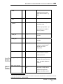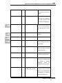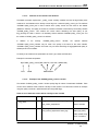
1
IMOS NETCDF USER’S MANUAL
NetCDF Conventions and Reference Tables
Version 1.3
February 27th, 2012
Sebastien Mancini, Katherine Tattersall, Roger Proctor, Guillaume
Galibert
[email protected]
IMOS
NetCDF User’s Manual: NetCDF Conventions and Reference Tables
Table of contents
PREFACE TO VERSION 1.3 ....................................................................................... V PREFACE TO VERSION 1.2 .............................................................................................. IX PREFACE TO VERSION 1.1 .............................................................................................. XI 1 - OVERVIEW ............................................................................................................. 1 1.1 - ABOUT IMOS ..............................................................................................................1 1.2 - ABOUT THIS DOCUMENT .........................................................................................1 1.3 - IMOS DATA MANAGEMENT STRUCTURE AND DATA ACCESS ............................2 2 - IMOS DATA FORMAT ............................................................................................ 2 3 - NETCDF FILE STRUCTURE .................................................................................. 7 3.1 - GLOBAL ATTRIBUTES ...............................................................................................7 3.1.1 - Definition ...........................................................................................................................7 3.1.2 - List of the core global attributes ........................................................................................7 3.1.3 - List of the optional global attributes .................................................................................12 3.1.4 - Time formats ...................................................................................................................16 3.1.4.1 - Actual time ................................................................................................................................... 16 3.1.4.2 - Time zone .................................................................................................................................... 17 3.1.5 - File versioning.................................................................................................................17 3.1.6 - Global Attributes added by the user ................................................................................18 3.2 - DATA FILE DIMENSIONS .........................................................................................18 3.3 - VARIABLES ...............................................................................................................19 3.3.1 - Coordinate variables .......................................................................................................20 3.3.1.1 - TIME............................................................................................................................................. 20 3.3.1.2 - Location (X- Y horizontal Space)................................................................................................. 23 3.3.1.2.1 - LATITUDE ........................................................................................................................... 24 3.3.1.2.2 - LONGITUDE ....................................................................................................................... 26 3.3.1.3 - Vertical coordinate ...................................................................................................................... 28 3.3.1.3.1 - DEPTH ................................................................................................................................ 28 3.3.1.3.2 - HEIGHT .............................................................................................................................. 31 3.3.2 - Data variables .................................................................................................................31 Version 1.3 – February 2012
i
IMOS
NetCDF User’s Manual: NetCDF Conventions and Reference Tables
3.3.3 - Ancillary variables ...........................................................................................................35 3.3.4 - Data variable attributes added by user............................................................................36 3.3.5 - Quality control (QC) ........................................................................................................36 3.3.5.1 - Introduction .................................................................................................................................. 36 3.3.5.2 - Quality Control sets used by the IMOS project ........................................................................... 36 3.3.5.3 - Definition of the variables and attributes ..................................................................................... 37 3.3.5.4 - Example of the <PARAM_quality_control> variable ................................................................... 37 3.3.5.5 - QC coordinate variables .............................................................................................................. 39 3.3.6 - Uncertainty......................................................................................................................40 3.3.6.1 - Introduction .................................................................................................................................. 40 3.3.6.2 - Implementation in IMOS .............................................................................................................. 40 3.3.6.3 - Example ....................................................................................................................................... 41 3.3.7 - Example (see Appendix 1) ..............................................................................................41 4 - IMOS METADATA FORMAT ............................................................................... 42 4.1 - IMOS MEST ...............................................................................................................42 5 - IMOS FILE NAMING CONVENTION.................................................................... 43 6 - REFERENCE TABLES ......................................................................................... 44 6.1 - IMOS PARAMETER DICTIONARY ...........................................................................44 6.2 - QUALITY CONTROL FLAG SCALE ..........................................................................49 6.2.1 - Introduction .....................................................................................................................49 6.2.2 - Quality Control Set ..........................................................................................................49 6.2.3 - SET 1 IMOS standard set using the IODE flags..............................................................50 6.2.4 - SET 2 ARGO quality control procedure ..........................................................................51 6.2.4.1 - ARGO measurement flag scale ................................................................................................... 51 6.2.4.2 - ARGO profile quality flags ........................................................................................................... 52 6.2.5 - SET 3 BOM quality control procedure (SST and Air-Sea fluxes).....................................54 6.2.6 - Set 4 WOCE quality control procedure (Multidisciplinary Underway Network – CO2
measurements) ...............................................................................................................55 6.3 - CELL METHODS .......................................................................................................56 7 - REFERENCES ...................................................................................................... 57 APPENDIX 1: EXAMPLE NETCDF FILE ................................................................... 59 APPENDIX 2: IMOS TOOLBOX OPTIONAL GLOBAL ATTRIBUTES .................... 63 Version 1.3 – February 2012
ii
IMOS
NetCDF User’s Manual: NetCDF Conventions and Reference Tables
APPENDIX 3: IMOS NETCDF FILENAMING CONVENTION V 1.4 ......................... 65 Version 1.3 – February 2012
iii
IMOS
NetCDF User’s Manual: NetCDF Conventions and Reference Tables
Index of Tables
Table 1 A CDL (Common Data Language) description of a NetCDF file that contains data from the IMOS
Ship of Opportunity Sea Surface Temperature Sub-Facility. CDL notation can be generated from NetCDF
files using the NetCDF utility ncdump. ....................................................................................................... 4 Table 2 List of core mandatory global attributes for IMOS NetCDF files ................................................... 8 Table 3 List of optional global attributes for IMOS NetCDF files ............................................................. 12 Table 4 An example list of Dimensions for an IMOS NetCDF file............................................................ 19 Table 5 List of attributes defining the TIME variable for IMOS NetCDF files ............................................ 21 Table 6 List of attributes that define the LATITUDE variable for IMOS NetCDF files ............................... 24 Table 7 List of attributes to define the LONGITUDE variable for IMOS NetCDF files ............................... 26 Table 8 List of attributes that define the DEPTH variable for IMOS NetCDF files .................................... 28 Table 9 List of data variables attributes for IMOS NetCDF files ............................................................... 32 Table 10 List of attributes used to define a Quality Control variable ........................................................ 37 Index of Reference Tables
Reference Table A : List of IMOS parameter names, standard names (or long names for Non CF
parameters) and units. Non-CF parameters are marked with the symbol "†”. .......................................... 45 Reference Table B : List of QC procedure flags used in the IMOS project............................................... 49 Reference Table C : IMOS standard set using the IODE flags................................................................. 50 Reference Table D : ARGO measurement flag scale............................................................................... 51 Reference Table E : ARGO profile quality flags ....................................................................................... 52 Reference Table F : BOM Quality Control procedure flags (SST and Air Sea Fluxes) ............................ 54 Version 1.3 – February 2012
iv
IMOS
NetCDF User’s Manual: NetCDF Conventions and Reference Tables
PREFACE to version 1.3
In response to comments and improvements for the ANMN (Australian National Moorings Network)
facility we have made a number of changes to the IMOS NetCDF user’s manual. These minor changes
are summarised below:
Global Attributes
Section 3.1 - has been modified to separate historical Table 2 in two tables
-
Table 2 and Table 4 in order to distinguish core from optional metadata.
-
Previous appendix 2 is now appendix 3.
-
New appendix 2 describes all new ANMN oriented optional global attributes.
In section “What” of
-
Table 2, attribute <naming_authority> is now mandatory.
-
Table 3, attributes <file_version> and <file_version_quality_control> have been added, as well as
a new section 3.1.5 - describing how to use them.
-
Table 3, attributes <institution_address> and <institution_postal_address> have been added.
-
Table 3, the attribute <instrument> has been added.
-
appendix
2,
attributes
<toolbox_input_file>,
<toolbox_version>,
<deployment_code>,
<instrument_serial_number>, <instrument_sample_interval>, <instrument_burst_interval> and
<instrument_burst_duration> have been added.
In section “Who” of
-
Table 2, attributes <data_center> and <author> are now mandatory.
In section “Where” of
-
Table
3,
attributes
<geospatial_lat_units>,
<geospatial_lon_units>
and
<geospatial_vertical_units> have been added.
-
appendix
2,
attributes
<instrument_nominal_height>,
<instrument_nominal_depth>,
<site_nominal_depth> and <site_depth_at_deployment> have been added.
In section “When” of
Version 1.3 – February 2012
v
IMOS
NetCDF User’s Manual: NetCDF Conventions and Reference Tables
-
appendix 2, attributes <time_deployment_start> and <time_deployment_end> have been added.
-
The convention used to describe the global attributes <author> and <principal_investigator> is
the following: last name and then first name separated by a comma.
-
Section 3.3.6.2 - has been renamed ‘Implementation in IMOS’.
-
In section 3.3.6.2 -, the definition of accuracy and precision are now given.
Variables
-
For the variable TIME, the attribute <calendar> is now mandatory (Table 5).
-
Section 3.3.1.3 - now deals with general vertical coordinate variables. Depth but also height are
described in sub-chapters. Two new datums “sensor” and “sea bottom” are available and
“surface” has been renamed “sea surface”
-
Two new variable attributes <applied_offset> and <sensor_serial_number> are available (Table
9).
-
Variable attribute <standard_name> is not mandatory anymore, but <long_name> is now
mandatory (Table 9).
-
Variable attribute <_FillValue> is not mandatory anymore for variables that are dimensions or that
are ancillary variables.
-
Variable attribute <quality_control_set> is not mandatory anymore for variables that are not
ancillary variables.
Other changes
-
Referenced NetCDF CF convention has been updated from version 1.4 to 1.6.
-
At the end of section 2 - given url strings have been converted into hyperlink.
-
Check and update of all hyperlinks when necessary.
-
In section 6.1 - it is now possible to deal with multiple instances of the same parameter.
Version 1.3 – February 2012
vi
IMOS
NetCDF User’s Manual: NetCDF Conventions and Reference Tables
-
IMOS MEST url has been updated.
-
In Reference Table A, the parameter ABSI has been added for acoustic_backscatter_intensity.
-
In
Reference
Table
A,
the
parameter
ADCP_CORR
has
been
added
for
adcp_correlation_magnitude.
-
In Reference Table A, the parameter ADCP_GOOD has been added for adcp_percentage_good.
-
In
Reference
Table
A,
the
parameter
CPHL
has
been
renamed
mass_concentration_of_chlorophyll_in_sea_water and is now CF (standard name table version
17).
-
In
Reference
Table
A,
the
parameter
CHLF
has
been
added
for
added
for
mass_concentration_of_chlorophyll_in_sea_water (factory calibration coefficient).
-
In
Reference
Table
A,
the
parameter
CHLU
has
been
mass_concentration_of_chlorophyll_in_sea_water (user calibration coefficient).
-
In
Reference
Table
A,
the
parameter
CHLR
has
been
added
for
DOX1
has
been
added
for
been
added
for
raw_concentration_of_chlorophyll_in_sea_water.
-
In
Reference
Table
A,
the
parameter
mole_concentration_of_dissolved_molecular_oxygen_in_sea_water.
-
In
Reference
Table
A,
the
parameter
DOXS
has
fractional_saturation_of_oxygen_in_sea_water.
-
In Reference Table A, the parameter ECUR has been added for error_sea_water_velocity.
-
In Reference Table A, the parameter FLU2 has been renamed fluorescence_in_sea_water.
-
In Reference Table A, the parameter FREQUENCY has been added for frequency.
-
In Reference Table A, the parameter HEADING has been added for heading.
-
In Reference Table A, the parameter HEIGHT_ABOVE_SENSOR has been added for
height_above_sensor.
-
In Reference Table A, the parameter NTRI is now CF (standard name table version 17).
-
In Reference Table A, the parameter PITCH has been added for platform_pitch_angle.
-
In
Reference
Table
A,
the
parameter
PRES_REL
has
been
added
for
sea_water_relative_pressure.
Version 1.3 – February 2012
vii
IMOS
NetCDF User’s Manual: NetCDF Conventions and Reference Tables
-
In Reference Table A, the parameter ROLL has been added for platform_roll_angle.
-
In Reference Table A, the parameter SLCA is now CF (standard name table version 17).
-
In
Reference
Table
A,
the
parameter
SSDS
has
been
added
for
sea_surface_wave_directional_spread.
-
In Reference Table A, the parameter SSPD has been added for speed_of_sound_in_sea_water.
-
In
Reference
Table
A,
the
parameter
SSWD
has
been
added
for
sea_surface_wave_direction_spectral_density.
-
In
Reference
Table
A,
the
parameter
SSWP
has
been
added
for
the
parameter
SSWV
has
been
added
for
added
for
WCUR
for
sea_surface_swell_wave_period.
-
In
Reference
Table
A,
sea_surface_wave_directional_variance_spectral_density.
-
In Reference Table A, the parameter VOLT has been added for voltage.
-
In
Reference
Table
A,
the
parameter
WAV_DIR
has
been
sea_surface_wave_from_direction.
-
In
Reference
Table
A,
the
parameter
ZCUR
has
been
renamed
upward_sea_water_velocity.
-
In Reference Table A, redundant parameters EWCT, NSCT and HCSP have been deleted.
-
In section 6.2.2 - the WOCE set of Quality Control procedure has been added. Section 6.2.6 has been created to describe this scale of QC flags.
Version 1.3 – February 2012
viii
IMOS
NetCDF User’s Manual: NetCDF Conventions and Reference Tables
PREFACE to version 1.2
eMII (eMarine Information Infrastructure) recently released version 1.1 of the NetCDF convention. In
response to comments we have made a number of changes to the IMOS NetCDF user’s manual. These
minor changes are summarised below:
Global Attributes
The attribute <date_modified> has been added (
-
Table 2).
The attribute <principal_investigator_name> has been renamed <principal_investigator> (
-
Table 2).
The attribute <principal_investigator_email> has been added (
-
Table 2).
Descriptions of the attributes <references> and <institution_references> have been clarified.
Multiple references need to be separated with a semicolon (
-
Table 2).
The ‘type’ of the global attributes has been added to
-
Table 2. The type values are S for string, N for numeric (byte, short, long, integer, float or
double), D for the type of the data variable and Q for the type of the corresponding quality control
data variable.
Variables
-
The ‘type’ of the variable attributes has been added (Table 5, Table 6, Table 7, Table 8, Table 9
and Table 10). The type values are S for string, N for numeric (byte, short, long, integer, float or
double), D for the type of the data variable and Q for the type of the corresponding quality control
data variable.
-
The attribute <QC_set> has been renamed more clearly as <quality_control_set> (Table 5, Table
6, Table 7, Table 8 , Table 9 and Table 10).
-
The attribute <QC_indicator> has been renamed more clearly as <quality_control_indicator>
(Table 5, Table 6, Table 7, Table 8 , Table 9 and Table 10).
Version 1.3 – February 2012
ix
IMOS
NetCDF User’s Manual: NetCDF Conventions and Reference Tables
-
The variable <PARAM_QC> has been renamed as <PARAM_quality_control> to be consistent
with the name of the different QC attributes.
-
The variable <PARAM_UNCERTAINTY has been renamed as <PARAM_uncertainty>.
-
The attribute <conventions> used to define a <PARAM_quality_control> variable has been
renamed to <quality_control_conventions>.
-
The
attribute
<quality_control_set>
has
been
added
to
define
a
<PARAM_quality_control>variable.
Other changes
-
Some changes have been made to clarify use of standard names in section 6.1 -and Reference
Table A. Only parameters that appear in the CF standard name table (http://cfpcmdi.llnl.gov/documents/cf-standard-names/) can use the <standard_name> attribute. Non-CF
parameters (marked with the symbol "†” in Reference Table A) can only use the <long_name>
attribute for their description.
-
In Reference Table A, the parameter RAIN has been renamed as RRATE.
-
In Reference Table A, the parameter RAIT has been renamed as RAIN_AMOUNT
-
In Reference Table A, the parameter TURB has been added for turbidity.
-
Some minor changes have been made to Table 1 and to the example found in section 3.3.3 -and
in Appendix 1.
-
The file naming convention (Appendix 2) has been updated to version (1.3).
Version 1.3 – February 2012
x
IMOS
NetCDF User’s Manual: NetCDF Conventions and Reference Tables
PREFACE to version 1.1
In response to comments received following our distribution of version 1.0 we have made a number of
changes to the IMOS netCDF user’s manual. These changes are summarised below:
Global Attributes
The
The global attribute <QC_indicator> has been removed from the convention (Table 2).
attribute
<contact>
has
been
removed
and
replaced
with
two
new
attributes :
<data_centre_email> and <author_email> (
-
Table 2).
-
The attribute <PI_name> has been renamed more clearly as <principal_investigator_name>
(Table 2).
-
Use of the attribute <local_time_zone> is described more clearly in the text (Section 3.1.4.2 -).
Description of the <keywords> attribute now specifies that GCMD keywords should be used
where possible (
-
Table 2).
Variables
-
In version 1.0 we asked that variable names were all in capital letters. In version 1.1, variable
names need not always be in capital letters (Section 3.3 -).
-
An additional attribute was added to describe the <TIME> variable. This attribute is <calendar>
and is used as defined in the CF-Convention (Eaton et al 2009) (Table 5).
-
Two new variable attributes were added: <sensor_height> and <observation_type> (Table 9).
-
The attribute <reference> has been renamed more clearly as <reference_datum> (Table 6, Table
7, Table 8 and Table 9).
-
A new section of the document describes the ancillary variables (QC and uncertainty) in detail,
and when they should be used (Section 3.3.3 -).
Version 1.3 – February 2012
xi
IMOS
NetCDF User’s Manual: NetCDF Conventions and Reference Tables
-
Use of the attributes QC_set and QC_indicator is described more clearly in the text in a new
section on Quality Control (Section 3.3.5.3 -).
-
A number of standardised parameter names/acronyms have been added to Reference Table A.
Other changes
-
Some web links in the previous version were not working. These have been replaced in version
1.1 with working links.
-
Additional references have been included in this version.
-
The file naming convention (Appendix 2) has been updated to the most recent version (1.2).
Version 1.3 – February 2012
xii
IMOS
NetCDF User’s Manual: NetCDF Conventions and Reference Tables
1 - OVERVIEW
1.1 - About IMOS
IMOS is a distributed set of equipment and data-information services which collectively contribute to
meeting the needs of marine climate research in Australia. The observing system provides data in the
open oceans around Australia out to a few thousand kilometres as well as the coastal oceans. The IMOS
Office coordinates the deployment of a wide range of equipment and assembles the data through 11
facilities distributed around the country. The data are made available to researchers through the
electronic Marine information Infrastructure (eMII) located at the University of Tasmania. The IMOS
infrastructure also contributes to Australia’s role in international programs of ocean observing.
IMOS was planned through extensive consultation with the Australian marine research community
through Nodes, including a Bluewater open ocean node and five regional nodes around the country.
IMOS is an initiative of the Australian Government being conducted as part of the National Collaborative
Research Infrastructure Strategy. IMOS is coordinated nationally and managed by staff at the University
of Tasmania.
1.2 - About this document
The main purpose of this document is to specify the format of the files that are used to distribute IMOS
data, and to document the standards used therein. This includes naming conventions, or taxonomy, as
well as metadata content.
The IMOS NetCDF convention manual was originally based on the one prescribed by the OceanSITES
User’s Manual, version 1.1. As both documents have evolved since, there might have now significant
differences between them. The OceanSITES program is the global network of open-ocean sustained time
series reference stations that have been implemented by an international partnership of researchers.
More information about this project is available at http://www.oceansites.org.
The IMOS NetCDF convention manual also draws on documents that have been produced for the IMOS
project (see References).
Version 1.3 – February 2012
1
IMOS
NetCDF User’s Manual: NetCDF Conventions and Reference Tables
1.3 - IMOS data management structure and data access
The eMarine Information Infrastructure (eMII) will provide a single integrative framework for data and
information management that will allow discovery and access of the data by scientists, managers and the
public.
eMII activity can be summarised as follows:
•
eMII will host, manage and archive data produced by the other IMOS facilities.
•
eMII will provide the standards, protocols and systems to integrate the data and related
information into a number of conformal frameworks, and will provide the tools to access and
utilise the data.
•
For some kinds of data, eMII will provide data products as web services and web features for
processing, integration and visualisation of data.
•
Where possible, eMII will integrate data from sources outside IMOS into IMOS data products and
export IMOS data to international programs.
2 - IMOS DATA FORMAT
Network Common Data Form (netCDF)
NetCDF is one of many file formats available for storing marine data. It is a relatively simple file format
that is self-describing and portable. “Self-describing” means it contains data about the data (metadata),
such as variable descriptions and units. “Portable” means that data in a dataset is represented in a form
that can be accessed by computers with different methods of storing integers, characters and floating
point numbers. It has a strong set of functional libraries that can be used to compress, subset and
transform data. The netCDF software libraries and documentation are available online from Unidata1.
Many netCDF manipulation and display software utilities are also available online.
NetCDF files contain the data as ‘variables’, which can be single numbers, vectors, or multi-dimensional
arrays. Variables can be of data types: char (character), byte, short, int (integer), float or real, and double.
NetCDF files contain data organised into a collection of named array variables along with named data file
attributes. The format is widely applicable to many data types.
1
http://www.unidata.ucar.edu/software/netcdf/
Version 1.3 – February 2012
2
IMOS
NetCDF User’s Manual: NetCDF Conventions and Reference Tables
However, netCDF has some limitations. Some constraints exist on sizes of large variables. Also, the
netCDF model does not support more than one unlimited dimension, nested data structures such as
trees, nested arrays or other recursive structures. The Unidata NetCDF User’s Guide thoroughly
documents the many benefits and few limitations of NetCDF format (Rew et al 2008) 2 .
The IMOS NetCDF Convention has been written to be used when writing data files in netCDF Classic
Format (version 3.6). Unidata released a netCDF-4 format in 2008. This format is more flexible than the
classic format and offers additional features such as groups, compound types and variable length arrays.
However, these files have a different underlying format to previous netCDF versions and cannot be read
with any version of the netCDF library previous to 4.0. Unidata encourage the use of netCDF Classic
Format to distribute data, for maximum portability (Rew et al 2008).
Common Data Language (CDL)
Common Data Language (CDL) is a human readable text notation that is used to describe the netCDF
objects. The netCDF utility ncdump can be used to convert netCDF object binary to CDL text. The
netCDF utility ncgen creates a netCDF binary file from a well-formed CDL text file.
A CDL description of a netCDF dataset takes the form:
netCDF name {
dimensions: ….
variables: ….
data: ….
}
Where the name is used only as a default in constructing file names by the ncgen utility. The CDL
description consists of three optional parts, each introduced by the keywords ‘dimensions’, ‘variables’ and
‘data’. NetCDF dimension declarations appear after the dimensions keyword, netCDF variables and
attributes are defined after the variables keyword, and variable data assignments appear after the data
keyword. CDL statements are terminated by a semicolon. Spaces, tabs and new lines can be used freely
for readability. Comments in CDL follow the characters ’//’ on any line (Rew et al 2008).
A simple CDL example which describes IMOS sea surface temperature data collected from a ship of
opportunity is shown in Table 1.
2
http://www.unidata.ucar.edu/software/netcdf/docs/netcdf
Version 1.3 – February 2012
3
IMOS
NetCDF User’s Manual: NetCDF Conventions and Reference Tables
Table 1 A CDL (Common Data Language) description of a NetCDF file that contains data from the
IMOS Ship of Opportunity Sea Surface Temperature Sub-Facility. CDL notation can be generated
from NetCDF files using the NetCDF utility ncdump.
netcdf IMOS_SOOP-SST_T_20071120T150000Z_VNSZ_FV01 {
dimensions:
// example CDL for NetCDF notation
// dimensions names are declared first
TIME = 5;
LONGITUDE = 3 ;
LATITUDE = 2 ;
variables:
// variable types, names, dimensions and attributes
double TIME(TIME) ;
TIME:long_name = "time" ;
TIME:units = "days since 1950-01-01 00:00:00Z" ;
TIME:standard_name = "time" ;
float LONGITUDE(LONGITUDE) ;
LONGITUDE:long_name = "longitude" ;
LONGITUDE:units = "degrees_east" ;
LONGITUDE:standard_name = "longitude" ;
float LATITUDE(LATITUDE) ;
LATITUDE:long_name = "latitude" ;
LATITUDE:units = "degrees_north" ;
LATITUDE:standard_name = "latitude" ;
float TEMP(TIME, LATITUDE, LONGITUDE) ;
TEMP:long_name = "Water Temperature in degrees C" ;
TEMP:units = "Celsius" ;
TEMP:standard_name = "sea_water_temperature" ;
TEMP:_FillValue = 99999 ;
TEMP:valid_min = -2.0 ;
TEMP:valid_max = 40 ;
// global attributes:
// METADATA
:project = "Integrated Marine Observing System" ;
:title = "IMOS_SOOP-SST_T_20071120T150000Z_VNSZ_FV01" ;
:institution = "Enhanced Measurements from Ship of Opportunity (SOOP)" ;
:Conventions = "CF-1.6, IMOS 1.3" ;
:date_created = "2007-12-10T02:10:30Z" ;
:source = "Ship observation" ;
:keywords = "Oceans>Ocean Temperature>Water Temperature" ;
:data_centre_email = "[email protected]" ;
:geospatial_lat_min = -35.0 ;
:geospatial_lat_max = -36.0 ;
:geospatial_lon_min = 151 ;
:geospatial_lon_max = 152 ;
// data:
// data assignments
TIME = 0.5, 1.5, 2.5, 3.5, 4.5 ;
LATITUDE = 54.2, 54.4, 54.6 ;
LONGITUDE = 2.1, 2.5 ;
TEMP = 34.5, 31.2, 23.7, 19.6, 35.8, 29.2, 24.4, 5.6, 7.2, 8.1, 18.6, 15.2, 13.1, 4.6, 3.7, 8.2, 9.7,
34.2, 26.7, 28.7, 2.1, 3.4, 5.6, 7.8, 9.0, 10.2, 11.2, 11.6, 11.7, 11.8 ;
}
Version 1.3 – February 2012
4
IMOS
NetCDF User’s Manual: NetCDF Conventions and Reference Tables
NetCDF conventions
IMOS uses the NetCDF Climate and Forecast (CF) Metadata Conventions v1.6 (Eaton et al 2011)
wherever possible. However, sometimes it was desirable to incorporate attributes or concepts from other
conventions to the IMOS convention. We have made clear notations in this document where the IMOS
netCDF convention diverges from the CF convention.
In tables, attributes that have not been derived from the CF convention are marked in the left margin of
the page as shown here.
CF conventions require conforming datasets to contain sufficient metadata that they are self-describing,
in the sense that each variable in the file has an associated description of what it represents, including
physical units if appropriate, and that each value can be located in space (relative to earth based
coordinates) and time (Eaton et al 2011). The CF convention supplies a standard vocabulary and some
metadata conventions.
IMOS data format
The IMOS netCDF data format will enable the inclusion of standard terms for the short names of both
coordinate and data variables (measurements). File names are created using an IMOS NetCDF
filenaming convention (see Appendix 3). Coordinate variables, which describe the dimensions of a data
set, are limited to a single set of 4-dimensional axes representing longitude, latitude, depth and time (X,
Y, Z and T) dimensions in any single file. If data cannot all be put onto a single time axis, then separate
files are created for these data.
An IMOS data file format will be flexible enough to contain all IMOS data variables.
IMOS NetCDF file conventions require that:
•
Units are compliant with CF/COARDS/Udunits;
•
The time parameter is encoded as recommended by COARDS and CF;
•
Parameters are given standard names from the CF table
•
Where time is specified as an attribute, the ISO8601 standard is used.
Version 1.3 – February 2012
5
IMOS
NetCDF User’s Manual: NetCDF Conventions and Reference Tables
For more information on CF, COARDS, NetCDF, Udunits, and ISO8601 see:
NetCDF:
http://www.unidata.ucar.edu/software/netcdf/docs/BestPractices.html
Udunits:
http://www.unidata.ucar.edu/software/udunits/
CF:
http://cf-pcmdi.llnl.gov/
COARDS:
http://ferret.wrc.noaa.gov/noaa_coop/coop_cdf_profile.html
ISO8601:
http://en.wikipedia.org/wiki/ISO_8601
Version 1.3 – February 2012
6
IMOS
NetCDF User’s Manual: NetCDF Conventions and Reference Tables
3 - NETCDF FILE STRUCTURE
3.1 - Global Attributes
3.1.1 -Definition
The global attribute section of a NetCDF file contains metadata that describes the overall contents of the
file and allows for data discovery. All fields should be human-readable and can be of either ‘character’ or
‘numeric’ type. IMOS recommends that all listed attributes be used and contain meaningful information
unless there are technical reasons rendering this impossible (for example, information not available for
historical data). Files must at least contain the attributes listed as “mandatory”. Please contact eMII if this
is proving difficult.
Global attributes can be thought of as conveying five kinds of information:
•
What: What are the data in the dataset
•
Where: The spatial coverage of the data
•
When: The temporal coverage of the data
•
Who: Who produced the data
•
How: How were the data produced and made available
3.1.2 -List of the core global attributes
Core global attributes are mandatory from the point of view of either the CF or IMOS convention.
Table 2 lists all the core global attributes used to define an IMOS dataset.
Mandatory fields are marked with an asterisk (
* ).
The “Type” values are S for string, N for numeric (byte, short, long, integer, float or double), D for the type
of the data variable and Q for the type of the corresponding quality control data variable.
Version 1.3 – February 2012
7
IMOS
NetCDF User’s Manual: NetCDF Conventions and Reference Tables
Table 2 List of core mandatory global attributes for IMOS NetCDF files
Name
Type
Example
Definition
What
* project
S
project
=
“Integrated
Marine Observing System”
The
scientific
project
that
produced the data. For data
produced
under
the
IMOS
project, the field must be filled
as shown in the example.
* Conventions
S
Conventions
=
“CF-
1.6,IMOS-1.3”
Name of the format convention
used by the dataset. Possibility
to
include
two
different
conventions if necessary. Here
the followed CF and IMOS
conventions must be present.
* title
S
title = “Radar data from
Tannum
Sands
Short description of the dataset
station,
Queensland”
* institution
S
institution = “ACORN”
Name of the institute or facility
where the original data was
produced
* date_created
S
date_created = “2008-11-
The date on which the file was
23T08:35:00Z”
created. See chapter 0 on
time format below.
* abstract
S
abstract = “…………….”
A paragraph describing the
dataset:
type
of
data
contained in the dataset, how
the data was created, the
creator of the dataset, the
Version 1.3 – February 2012
8
IMOS
NetCDF User’s Manual: NetCDF Conventions and Reference Tables
project for which the data was
created,
the
geospatial
coverage of the data, the
temporal coverage of the data.
In some instances the abstract
may be autogenerated from
other netCDF fields.
Please
discuss this with eMII staff if
you think autogeneration will
be appropriate for your data.
* keywords
S
keywords = “Oceans >
A comma separated list of key
Ocean
>
words and phrases. To be
Ocean Currents , Oceans
consistent with the MEST we
>
recommend using the GCMD
Circulation
Ocean
Waves
>
Significant Wave Height
vocabulary
(Olsen
et.al.,
,…”
2007). The GCMD keywords
list can be downloaded from:
http://gcmd.nasa.gov/Resourc
es/valids/archives/keyword_list
.html
Non-GCMD keywords may be
used at your discretion
* naming_authority
S
naming_authority
=
This will always be “IMOS”
“IMOS”
Where
* geospatial_lat_min
N
geospatial_lat_min = 59.8
The southernmost latitude, a
value between -90 and 90
decimal degrees North if not
specified.
* geospatial_lat_max
N
geospatial_lat_max = 59.8
The northernmost latitude, a
value between -90 and 90
decimal degrees North if not
specified.
Version 1.3 – February 2012
9
IMOS
NetCDF User’s Manual: NetCDF Conventions and Reference Tables
* geospatial_lon_min
N
geospatial_lon_min =-41.2
The westernmost longitude, a
value between -180 and 180
decimal degrees East if not
specified.
* geospatial_lon_max
N
geospatial_lon_max=-41.2
The easternmost longitude, a
value between -180 and 180
decimal degrees East if not
specified.
*geospatial_vertical_min
N
geospatial_vertical_min =
Minimum
depth
for
10.0
measurements in metres if not
specified.
*geospatial_vertical_max
N
geospatial_vertical_max =
Maximum
depth
for
2000
measurements in metres if not
specified.
When
*time_coverage_start
S
time_coverage_start
=
“2008-11-23T08:35:00Z”
Start date of the data in UTC.
See chapter 0 on time format
below
*time_coverage_end
S
time_coverage_end
=
“2009-01-06T15:47:00Z”
Final date of the data in UTC.
See chapter 0 on time format
below
Who
* data_centre
S
data_centre
Information
=
“eMarine
Data centre in charge of the
Infrastructure
data management or party
(eMII)”
*data_centre_email
S
* author
S
data_centre_email
who distributed the resource
=
Data Centre contact e-mail
“[email protected]”
address
author = “Doe, John”
Name
of
the
person
responsible for the creation of
the dataset. Convention is last
name and then first name
Version 1.3 – February 2012
10
IMOS
NetCDF User’s Manual: NetCDF Conventions and Reference Tables
separated by a comma.
*principal_investigator
S
principal_investigator
=
“Doe, John”
Name
of
the
principal
investigator in charge of the
platform. Convention is last
name and then first name
separated by a comma.
How
*citation
S
The citation to be used in
citation =
publications using the dataset
Integrated Marine
should follow the format:
Observing System. 2008,
"Australian Acoustic
Tagging and Monitoring
System (AATAMS) data",
http://imos.org.au/emii_aat
“IMOS. [year-of-datadownload], [Title], [Data
access URL], accessed [dateof-access]”.
ams.html, accessed 20
Dec 2008.
*acknowledgement
S
acknowledgement =
Any
users
(including
re-
packagers) of IMOS data are
"Data was sourced from
the
Integrated
Marine
Observing System (IMOS)
required
to
clearly
acknowledge the source of the
material in this format.
– IMOS is supported by
the Australian Government
through
the
National
Collaborative
Research
Infrastructure
Strategy
(NCRIS) and the Super
Science Initiative (SSI)."
*distribution_statemen
t
S
distribution_statement =
Statement
describing
data
distribution policy:
Data
may
be
re-used,
that
related
Re-packagers of IMOS data
metadata explaining the
should include a statement
data has been reviewed
that information about data
by the user, and the data
quality and lineage is available
is
from the metadata record and
provided
appropriately
Version 1.3 – February 2012
11
IMOS
NetCDF User’s Manual: NetCDF Conventions and Reference Tables
acknowledged. Data,
a
products
services
products and services from
from IMOS are provided
IMOS are provided "as is"
"as
without any warranty as to
is"
and
without
any
statement
warranty as to fitness for a
fitness
particular purpose.
purpose.
for
that
a
data,
particular
3.1.3 -List of the optional global attributes
Table 3 below lists some of the optional global attributes than can be used by any facility to describe an
IMOS NetCDF dataset.
For some example of facility oriented optional global attributes definitions, see appropriate Appendix.
The “Type” values are S for string, N for numeric (byte, short, long, integer, float or double), D for the type
of the data variable and Q for the type of the corresponding quality control data variable.
Table 3 List of optional global attributes for IMOS NetCDF files
Name
Type
Example
Definition
date_modified = “2008-12-
The date on which the data
23T20:35:00Z”
was modified. See chapter 0
What
date_modified
S
on time format below. If this
attribute is used for the first
time or modified, a new entry
needs to be added to the
“history” attribute.
history
S
history = “…………..”
Provides an audit trail for
modifications to the original
data.
It
should
separate
line
contain
for
a
each
modification, with each line
beginning with a timestamp
and
including
modification
user
name,
name
and
modification arguments.
Version 1.3 – February 2012
12
IMOS
NetCDF User’s Manual: NetCDF Conventions and Reference Tables
comment
S
comment =“………………”
Miscellaneous
information
about the data or methods
used to produce it. Any freeformat text is appropriate
source
instrument
S
S
source
=
“Radar
Method of production of the
Observation”
original data
instrument = “WETLABS
Make
WQM”
instruments from which the
and
model
of
the
data has been collected.
references
S
references
“http://www.imos.org.au”
=
Published
or
web-based
references that describe the
data or the methods used to
produce the data. Include a
reference to IMOS and a
project-specific
reference
appropriate.
if
Multiple
references
should
be
separated with a semicolon “;”.
netcdf_version
N
netcdf_version = 3.6
NetCDF version used for the
dataset
quality_control_set
N
quality_control_set = 1
Definition of the Quality control
set used for the data, if the
same for all variables
See IMOS Reference Table B
site_code
S
site_code = “………..”
Name of the site within IMOS
project.
platform_code
S
platform_code = “TAN”
Platform unique code within
IMOS project. The platform
codes are listed in Naming
Reference
Appendix
Table
3
“File
3
in
naming
convention for netCDF files”.
Version 1.3 – February 2012
13
IMOS
NetCDF User’s Manual: NetCDF Conventions and Reference Tables
cdm_data_type
S
cdm_data_type = “Station”
The “cdm_data_type” attribute
gives
the
Unidata
CDM
(Common Data Model) data
type used by THREDDS. E.g.
“Point”, “Trajectory”, “Station”,
“Radial”, “Grid”, “Swath”.
More
information
on
http://www.unidata.ucar.edu/pr
ojects/THREDDS/CDM/CDMTDS.htm
metadata
S
metadata = “ http://.......”
URL to the metadata record
corresponding to the netCDF
file.
eMII are considering adding
this information to the data
files as part of eMII data
processing.
Facilities
would
not be required to complete
these fields when submitting
data.
sensorML
S
sensorML = “ http://........”
Link to the sensorML record
corresponding to the netCDF
file.
eMII
are
considering
adding this information to the
data files as part of eMII data
processing.
Facilities
would
not be required to complete
these fields when submitting
data.
institution_address
S
institution_address
=
Address of the institute or
“Oceanography laboratory,
facility where the original data
School
was produced.
of
Mathematics
and Statistics, University
of
New
South
Wales,
Sydney NSW 2052”
Version 1.3 – February 2012
14
IMOS
NetCDF User’s Manual: NetCDF Conventions and Reference Tables
institution_postal_addr
S
ess
institution_postal_address
Postal address of the institute
= “University of New South
or facility where the original
Wales,
data was produced.
Sydney
NSW
2052”
file version
S
file_version = “Level 0 –
Information
about
the
file
Raw data”
version of the file. Three levels
are possible at the moment:
-
Level 0 – Raw data
-
Level
1
–
Quality
Controlled data
-
Level
2
–
Derived
the
Quality
product
file_version_quality_co
S
ntrol
file_version_quality_contro
Description
l = “Data in this file has not
Control procedure applied to
been quality controlled”
the data. See chapter 3.1.5 for
more
of
information
and
examples.
Where
geospatial_lat_units
S
geospatial_lat_units
=
“degrees_north”
Units
used
for
geospatial_lat_min/max
attributes.
geospatial_lon_units
S
geospatial_lon_units
=
“degrees_east”
Units
used
for
geospatial_lon_min/max
attributes.
geospatial_vertical_unit
S
s
geospatial_vertical_units =
Units
used
for
“metres”
geospatial_vertical_min/max
attributes.
When
local_time_zone
N
local_time_zone = 10
Local time zone. See chapter
0 on time format below. If local
time does not fall into one
zone for the full dataset, do
not use this attribute.
Version 1.3 – February 2012
15
IMOS
NetCDF User’s Manual: NetCDF Conventions and Reference Tables
Who
author_email
S
principal_investigator_
S
email
institution_references
S
author_email
=
NetCDF file author contact e-
“[email protected]”
mail address
principal_investigator_email
Principal Investigator e-mail
= “[email protected]”
address
institution_references
References that describe the
=
“http://imos.org.au/emii.html”
data provider institution, the
place to find all information on
the dataset (web-based, i.e.
give URLs).
Multiple references should be
separated with a semicolon “;”.
3.1.4 -Time formats
Time consists of three components:
•
The actual time as hours, minutes and seconds
•
The time zone of the location at which the measurement was made
•
The reference point against which the time is measured
3.1.4.1 -
Actual time
All time will be recorded in hours, minutes, seconds and decimal fractions of seconds relative to UTC that
is Universal Time Coordinate or the old GMT.
Whenever time information is given in the global attributes, it ought to be a string of the format: “YYYYMM-DDThh:mm:ssZ” (i.e. year – month – day T hour : minute : second Z)
If higher resolution than seconds is needed, any number of decimal digits (“.s”) for the seconds is
acceptable: “YYYY-MM-DDThh:mm:ss.sZ”
Version 1.3 – February 2012
16
IMOS
NetCDF User’s Manual: NetCDF Conventions and Reference Tables
Time will be recorded using the international standard ISO 8601 (International Organization for
Standardization, 2009). Examples of the time format are shown below.
2005-10-24T08:00:00Z
2008-01-01T22:50:02.03Z
3.1.4.2 -
Time zone
The time zone value gives the local time which is important in considering many biological processes and
phenomena. For example, we may measure time as hours, minutes and seconds from a reference such
as UTC but to be able to relate that to local diurnal processes we also need to know the local time zone.
The local time zone will be recorded as the hours plus or minus from the longitude meridian.
Examples of the time format are shown below:
2008-10-24T08:00:00Z (UTC)
2008-10-24T18:00:00+10 (Local)
The value (eg. +10) should be included in the global attribute local_time_zone.
Corrections from local to UTC time for Australian time zones can be found online at:
http://www.timeanddate.com/worldclock/timezone.html?n=396
The global attribute ‘local_time_zone’ should be used only when all data points in a dataset are from the
same local time zone. If time zone changes during the dataset (e.g. moving point measurements on a
ship of opportunity) then do not use this global attribute. Instead, advanced users may choose to create a
user-defined variable called ‘local_time_zone’. If local time zone is not defined in the dataset, it will be
calculated by data users from the lat/long coordinate and UTC time variables.
3.1.5 -File versioning
Two attributes <file_version> and <file_version_quality_control> define the file version of the NetCDF file
and describe the Quality Control (QC) procedure used for the dataset.
Version 1.3 – February 2012
17
IMOS
NetCDF User’s Manual: NetCDF Conventions and Reference Tables
Three possibilities are available for these two attributes:
Global attribute <file_version>
Examples of use of the global attribute <file_version_quality_control>
Level 0 – Raw data
Data in this file has not been quality controlled
Level 1 – Quality Controlled
Data in this file has been through the BOM quality control procedure
data
(Reference Table F). Every data point in this file has an associated
quality flag.
level 2 – Derived product
All data in this file has been through the quality control procedure
(Reference Table F) and was classed Z (passes all tests).
3.1.6 -Global Attributes added by the user
The global attributes listed in the table in the chapter 3.1.2 - are most important to define a dataset as
clearly as possible. However, this list will not in all cases be exhaustive and eMII requests that other
meaningful global attributes be used where necessary.
It is possible to add global attributes to meet specific facility needs. New attributes will need to be self
defined, including a description and an example of how it is used. User-defined global attributes should
be added to the existing list (appropriate appendix section) in the next version of the IMOS NetCDF
User’s manual.
An example of an ‘user defined’ global attribute and supporting information is below:
This example can be used by the ACORN facility to illustrate the kind of data and the type of radar used
to produce the data. The prefix “ssr” added to each attribute means “sea surface radar”.
ssr_Data_Type = “Range_Time_Series”
ssr_Radar
= “Helzel/WERA”
3.2 - Data File Dimensions
NetCDF file dimensions provide information on the number and size of the data variables. IMOS allows a
single variable for each of the data dimensions, i.e. time, depth, latitude and longitude. There may only be
one unlimited dimension, i.e. as many instances of this variable as needed, for a limited number of
Version 1.3 – February 2012
18
IMOS
NetCDF User’s Manual: NetCDF Conventions and Reference Tables
coinciding variables. Other dimensions may be greater than 1, but must be defined and may not be
unlimited. Coordinate types other than latitude, longitude, depth and time are allowed.
The example in Table 4 allows for measurements at an unlimited number of time steps, at five different
depths and one latitude, longitude, position, frequency and direction.
Requirements are described further in the section on coordinate variables (3.3.1 -).
Table 4 An example list of Dimensions for an IMOS NetCDF file
Name
Example
Comment
TIME
TIME = unlimited
Number of time steps
DEPTH
DEPTH = 5
Number of depth levels
LATITUDE
LATITUDE = 1
Dimension of the latitude
coordinate variable
LONGITUDE
LONGITUDE = 1
Dimension of the longitude
variable
POSITION
POSITION = 1
Dimension of the POSITION
variable
FREQUENCY
FREQUENCY = 1
Number of frequency levels
DIRECTION
DIRECTION = 1
Number of direction levels
3.3 - Variables
NetCDF variables include data measured by instruments, parameters derived from the primary
measurements and coordinate variables, which may be nominal values such as values for depth for
instruments that do not directly record depth. Defined variable names are listed in Reference Table A.
Each variable has a specific set of attributes, some of which are mandatory.
The “Type” values are S for string, N for numeric (byte, short, long, integer, float or double), D for the type
of the data variable and Q for the type of the quality control data variable.
Version 1.3 – February 2012
19
IMOS
NetCDF User’s Manual: NetCDF Conventions and Reference Tables
This section will be divided into 5 different sub-sections as listed below:
•
The coordinate variables
•
The data variables
•
Quality control ‘sets’
•
Defining uncertainties in data measurement
•
An example of a NetCDF header.
3.3.1 -Coordinate variables
The coordinate variables orient the data in time and space. For this purpose, they have an “axis” attribute
defining that they point in X, Y, Z and T dimensions. The X and Y of course represent horizontal space
while for oceanography Z is depth or height and T is time.
The use of a common set of spatial and temporal units and measures is the basic requirement to be able
to integrate the various data collected by the IMOS project.
3.3.1.1 -
TIME
All time will be recorded in fractions of days from a reference time relative to UTC that is Universal Time
Coordinate or the old GMT.
Time consists of three components:
•
The actual time as the number of days since the reference time
•
The time zone of the location at which the measurement was made
•
The reference point against which the time is measured
The third component is used to define the reference point in the attribute named “units”. eMII suggests
that all the IMOS data should use the ARGO reference time of 1st of January of 1950. The value will be
stored as the number of days since this reference time.
Version 1.3 – February 2012
20
IMOS
NetCDF User’s Manual: NetCDF Conventions and Reference Tables
To identify the time variable, three parameters are used: Type, Name and Dimension.
Example : Double TIME(TIME)
Type
Name
Dimension
The following table presents the different attributes used to represent the time variable. Mandatory fields
are marked with an asterisk (
*)
Table 5 List of attributes defining the TIME variable for IMOS NetCDF files
Attributes
* standard_name
Type
S
Example
Comment
standard_name=“time”
A standard name that references
a description of a variable’s
content in the standard name
table
* long_name
S
long_name = “ time ”
A descriptive name that indicates
a variable’s content. This name
is not standardized.
* units
S
units
= “days since
Units of a variable’s content.
1950-01-01 00:00:00Z”
Date and time (UTC) of the
measurement in days since
1950-01-01 00:00:00
Example :Noon, Jan 2, 1950 is
stored as 1.5
July 25, 2001, 19:14:00 is stored
as 18833.8013889
Please contact eMII if you
require help with this conversion:
[email protected]
Version 1.3 – February 2012
21
IMOS
NetCDF User’s Manual: NetCDF Conventions and Reference Tables
* axis
S
axis
= “T”
Identifies time axes
* valid_min
N
valid_min = 0
Smallest valid value of a variable
* valid_max
N
valid_max = 90000.0
Largest valid value of a variable
_FillValue
D
_FillValue = 999999.0
A value used to represent
missing or undefined data 3.
Actually non-CF for dimensions.
* calendar
S
calendar = “gregorian”
Calendar used for encoding time
axes. See Eaton et. al. 2009 for
clarification.
comment
S
comment = “…….”
Miscellaneous information about
the data or methods used to
produce it.
quality_control_set
N
quality_control_set = 1
A value representing the Quality
control set used to the data. See
IMOS Reference Table B.
quality_control_indicator
Q
quality_control_indicator
This attribute may be used if the
= <X>
quality of ‘time’ data is constant
throughout the dataset. This
allows user to quickly assess if
all the data is good, without
looking at the _quality_control
variable. However, the quality
control variable
TIME_quality_control must still
be defined as discussed in
section 3.3.5 -. See IMOS
Reference Tables C to F.
3
Some users will create netCDF files with Matlab which contain a “not-a-number” (NaN) fill value. We ask that this NaN value be
replaced with a float value e.g. _FillValue of 999999.
Version 1.3 – February 2012
22
IMOS
NetCDF User’s Manual: NetCDF Conventions and Reference Tables
uncertainty
N
uncertainty
= <Z>
<Z> : Overall measurement
uncertainty. Choose appropriate
value. See section 3.3.6 -.
local_time_zone
N
local_time_zone =+10
A value used to represent the
local time zone if it remains
constant throughout the dataset.
Example :
Double TIME(TIME) ;
TIME:long_name = “time” ;
TIME:standard_name = “time” ;
TIME:units = “days since 1950-01-01 00:00:00Z” ;
TIME:axis = “T” ;
TIME:valid_min = 0 ;
TIME:valid_max = 90000.0 ;
TIME:_FillValue = 999999.0 ;
TIME:calendar = “gregorian”
TIME:quality_control_set = 1
TIME:quality_control_indicator = 1
TIME:uncertainty = 0.003
TIME:local_time_zone = +10
3.3.1.2 -
Location (X- Y horizontal Space)
With the advent of GPS systems, it is now possible to measure position in space easily and accurately.
The location will be measured by GPS or equivalent as Latitude/Longitude in Decimal degrees using the
WGS84 projection with locations south of the equator having negative Latitude and locations west of zero
degrees of Longitude having negative Longitude.
Table 6 and Table 7 present the different attributes used to define the variables LATITUDE and
LONGITUDE.
Version 1.3 – February 2012
23
IMOS
NetCDF User’s Manual: NetCDF Conventions and Reference Tables
3.3.1.2.1 -
LATITUDE
Table 6 List of attributes that define the LATITUDE variable for IMOS NetCDF files
Attributes
* standard_name
Type
S
Example
Comment
standard_name =
A standard name that references
“latitude”
a description of a variable’s
content in the standard name
table
Latitude of the measurements
* long_name
S
long_name = “latitude”
A descriptive name that
indicates a variable’s content.
This name is not standardized.
* units
S
units = “degrees_north”
Units: degrees north ; southern
latitudes are negative
Example : -44.4991 for 44 29’
56.76” S
* axis
S
axis
=“Y”
Identifies Y axes
* valid_min
N
valid_min = -90
Smallest valid value of a variable
* valid_max
N
valid_max = 90
Largest valid value of a variable
_FillValue
D
_FillValue = 999999.0
A value used to represent
missing or undefined data4.
Actually non-CF for dimensions.
comment
S
comment = “ …….”
Miscellaneous information about
the data or methods used to
produce it.
4
Some users will create netCDF files with Matlab which contain a “not-a-number” (NaN) fill value. We ask that this NaN value be
replaced with a float value e.g. _FillValue of 99999.
Version 1.3 – February 2012
24
IMOS
NetCDF User’s Manual: NetCDF Conventions and Reference Tables
quality_control_set
N
quality_control_set = 1
A value representing the Quality
control set used to the data. .
See IMOS Reference Table B.
quality_control_indicator
Q
quality_control_indicator
This attribute may be used if the
= <X>
quality of ‘latitude’ data is
constant throughout the dataset.
This allows user to quickly
assess if all the data is good,
without looking at the
_quality_control variable.
However, the variable
LATITUDE_quality_control must
still be defined. See IMOS
Reference Tables C to F.
uncertainty
N
uncertainty = <Z>
<Z> : Overall measurement
uncertainty. Choose appropriate
value. See section 3.3.6 -.
* reference_datum
S
reference_datum =
Text description of the
“geographical
geographic reference datum for
coordinates, WGS84
the variable
projection”
Example:
Float LATITUDE(LATITUDE) ;
LATITUDE:long_name = “latitude” ;
LATITUDE:standard_name = “latitude” ;
LATITUDE:units = “degrees_north” ;
LATITUDE:axis = “Y” ;
LATITUDE:valid_min = -90 ;
LATITUDE:valid_max = 90 ;
LATITUDE:_FillValue = 999999.0 ;
LATITUDE:quality_control_set = 1
LATITUDE:quality_control_indicator = 1
LATITUDE:uncertainty = 0.001
LATITUDE:reference-datum = “geographical coordinates, WGS84 projection“
Version 1.3 – February 2012
25
IMOS
NetCDF User’s Manual: NetCDF Conventions and Reference Tables
3.3.1.2.2 -
LONGITUDE
Table 7 List of attributes to define the LONGITUDE variable for IMOS NetCDF files
Attributes
* standard_name
Type
S
Example
Comment
standard_name =
A standard name that references
“longitude ”
a description of a variable’s
content in the standard name
table
Longitude of the measurements
* long_name
S
long_name =
A descriptive name that
“longitude”
indicates a variable’s content.
This name is not standardized.
* units
S
units = “degrees_east”
Units: degrees east ; western
longitudes are negative
Example : -16.7222 for 16 43’
19.92” W
* axis
S
axis = “ X ”
Identifies X axes
* valid_min
N
valid_min = -180
Smallest valid value of a variable
* valid_max
N
valid_max = 180
Largest valid value of a variable
_FillValue
D
_FillValue = 999999.0
A value used to represent
missing or undefined data5.
Actually non-CF for dimensions.
comment
S
comment = “ ……….”
Miscellaneous information about
the data or methods used to
5
Some users will create netCDF files with Matlab which contain a “not-a-number” (NaN) fill value. We ask that this NaN value be
replaced with a float value e.g. _FillValue of 99999.
Version 1.3 – February 2012
26
IMOS
NetCDF User’s Manual: NetCDF Conventions and Reference Tables
produce it.
quality_control_set
N
quality_control_set = 1
A value representing the Quality
control set used to the data. .
See IMOS Reference Table B.
quality_control_indicator
Q
quality_control_indicator
This attribute may be used if the
= <X>
quality of ‘longitude’ data is
constant throughout the dataset.
This allows user to quickly
assess if all the data is good,
without looking at the
_quality_control variable.
However, the variable
LONGITUDE_quality_control
must still be defined.. See IMOS
Reference Tables C to F.
uncertainty
N
uncertainty = <Z>
<Z> : Overall measurement
uncertainty. Choose appropriate
value. See section 3.3.6 -.
* reference_datum
S
reference_datum =
Text description of the
“geographical
geographic reference datum for
coordinates, WGS84
the variable
projection”
Example:
Float LONGITUDE(LONGITUDE) ;
LONGITUDE:long_name = “longitude” ;
LONGITUDE:standard_name = “longitude” ;
LONGITUDE:units = “degrees_east” ;
LONGITUDE:axis = “X” ;
LONGITUDE:valid_min = -180 ;
LONGITUDE:valid_max = 180 ;
LONGITUDE:_FillValue = 999999.0 ;
LONGITUDE:quality_control_set = 1
LONGITUDE:quality_control_indicator = 1
Version 1.3 – February 2012
27
IMOS
NetCDF User’s Manual: NetCDF Conventions and Reference Tables
LONGITUDE:uncertainty = 0.001
LONGITUDE:reference_datum = “geographical coordinates, WGS84 projection”
3.3.1.3 -
Vertical coordinate
Any vertical coordinate must be referenced from a point or datum (attribute reference_datum) and defined
with a direction (attribute positive). Four datums are recognised: Mean Sea Level (MSL) sea surface, sea
bottom and sensor. The time and location of the instrument will need to be included to allow for tide
corrections. When necessary, any vertical measurement should be converted into one of the acceptable
datums. Two directions are recognised: up or down.
3.3.1.3.1 -
DEPTH
Depth will be measured as positive values with increasing depth as measured from a reference point or
datum. All depth measurements will be recorded as an offset or a distance from a reference datum, such
as metres below the surface or metres below MSL.
Depth should be measured in metres or other SI units. Depth measured as pressure should be converted
to metres and not left as pressure; if the pressure measurements are required these should be recorded
as a separate data stream. It is not permissible to label a pressure measurement as “depth”; a depth
measurement will always be in metres.
Table 8 presents the different attributes used to describe the DEPTH variable.
Table 8 List of attributes that define the DEPTH variable for IMOS NetCDF files
Attributes
* standard_name
Type
S
Example
Comment
standard_name =
A standard name that
“depth”
references a description of a
variable’s content in the
standard name table
Depth of each measurement
* long_name
S
long_name = “depth”
A descriptive name that
indicates a variable’s content.
This name is not standardized.
Version 1.3 – February 2012
28
IMOS
NetCDF User’s Manual: NetCDF Conventions and Reference Tables
* units
S
units = “ metres ”
Example : 513 for a
measurement 513 metres
below reference datum, e.g.
MSL
* axis
S
axis = “ Z ”
Identifies Z axes
* positive
S
positive = “down ”
Direction of increasing vertical
coordinate value.
Z axes may be positive = “up”
(atmospheric) or negative =
“down” (oceanic)
* valid_min
N
* valid_max
N
_FillValue
D
valid_min
=0
Smallest valid value of a
variable
valid_max = 12000
Largest valid value of a
variable
_FillValue = -99999.0
A value used to represent
missing or undefined data6.
Actually non-CF for
dimensions.
comment
S
comment = “ ……….”
Miscellaneous information
about the data or methods
used to produce it.
quality_control_set
N
quality_control_set = 1
A value representing the
Quality control set used to the
data. . See IMOS Reference
Table B.
quality_control_indicator
Q
quality_control_indicator =
This attribute may be used if
<X>
the quality of ‘depth’ data is
constant throughout the
dataset. This allows user to
6
Some users will create netCDF files with Matlab which contain a “not-a-number” (NaN) fill value. We ask that this NaN value be
replaced with a float value e.g. _FillValue of 99999.
Version 1.3 – February 2012
29
IMOS
NetCDF User’s Manual: NetCDF Conventions and Reference Tables
quickly assess if all the data is
good, without looking at the
_quality_control variable.
However, the variable
DEPTH_quality_control must
still be defined.. See IMOS
Reference Tables C to F.
* uncertainty
N
uncertainty = <Z>
<Z> : Overall measurement
uncertainty. Choose
appropriate value.
See section 3.3.6 -.
* reference_datum
S
reference_datum =
Text description of the
“Mean Sea Level
reference datum for the
(MSL)”
variable
Example:
Float DEPTH(DEPTH) ;
DEPTH:long_name = “depth of each measurement” ;
DEPTH:standard_name = “depth” ;
DEPTH:units = “metres” ;
DEPTH:axis = “Z” ;
DEPTH:positive = “down” ;
DEPTH:valid_min = 0 ;
DEPTH:valid_max = 12000 ;
DEPTH:_FillValue = -999999.0 ;
DEPTH:quality_control_set = 1
DEPTH:quality_control_indicator = 1
DEPTH:uncertainty = 0.001
DEPTH:reference_datum = “Mean Sea Level (MSL)”
Version 1.3 – February 2012
30
IMOS
NetCDF User’s Manual: NetCDF Conventions and Reference Tables
3.3.1.3.2 -
HEIGHT
Height will be measured as positive values with increasing height as measured from a reference point or
datum.
All height measurements will be recorded as an offset or a distance from a reference datum, such as
metres above sea bottom or metres above sensor.
Height should be measured in metres or other SI units.
3.3.2 -Data variables
The variable names are standardized in IMOS Reference Table A. For example, TEMP represents the
sea water temperature and PSAL represent the sea water salinity. The data variables should begin with a
letter and be composed of letters, digits and underscores.
To identify a variable, three parameters are used: type, Name and Dimension. In data variable definitions,
the dimensions (TIME, DEPTH, LATITUDE, LONGITUDE) must be used in this order (if present) as they
appear in CDL. When “extra” dimensions are used, such as with model runs, they should appear to the
left of the standard dimensions in a variable definition.
In some cases, two instruments may measure the same variable (e.g. wind speed measured by two
anemometers mounted on the same vessel). In these cases, the second instance of a variable should be
identified with the suffix ‘_2’. When wind speed is measured twice the variables would be defined as
WSPD and WSPD_2. Several variable attributes can be used to specify the differences, including
comments, descriptive attributes (sensor_depth, sensor_height) and long names. Two anemometers
might be distinguished in their long names as wind_speed_starboard and wind_speed_port.
Example for the sea water temperature:
Float TEMP(TIME, DEPTH, LATITUDE, LONGITUDE)
TYPE
NAME
DIMENSION
The following table presents the different attributes used to represent a specific variable. Mandatory fields
are marked with an asterisk (
*)
Version 1.3 – February 2012
31
IMOS
NetCDF User’s Manual: NetCDF Conventions and Reference Tables
Table 9 List of data variables attributes for IMOS NetCDF files
Attributes
standard_name
Type
S
Example
standard_name
Comment
=
A CF standard name that
“sea_surface_temperature”
references a description of
a variable’s content in the
standard name table. See
Reference Table A.
* units
S
units = “Celsius”
Units
* _FillValue
D
_FillValue = 999999
A value used to represent
* long_name
S
missing or undefined data7
long_name = “ Surface
A descriptive name that
temperature
indicates
in
Celsius”
degree
a
variable’s
content. This name is the
same as the CF standard
name
(if
that
exists).
Otherwise it is the IMOS
long
name
given
in
Reference Table A. Please
contact eMII regarding any
parameters
that
don’t
appear in the table
valid_min
N
valid_min = -2.0
Minimum value for valid
data
valid_max
N
valid_max = 40
Maximum value for valid
data
add_offset
N
add_offset = 25
If present for a variable,
this number is to be added
to the data after it is read
by an application. If both
scale_factor
and
add_offset attributes are
7
Some users will create netCDF files with Matlab which contain a “not-a-number” (NaN) fill value. We ask that this NaN value be
replaced with a float value e.g. _FillValue of 99999.
Version 1.3 – February 2012
32
IMOS
NetCDF User’s Manual: NetCDF Conventions and Reference Tables
present, the data are first
scaled before the offset is
added.
scale_factor
N
scale_factor = 0.01
If present for a variable, the
data are to be multiplied by
this factor after the data
are read by an application.
applied_offset
N
applied_offset = -10.1325
if present for a variable, this
offset has been added to
the original data to correct
it.
original_units
S
original_units = “……”
Original units of a variable’s
content
original_name
S
original_name = “……”
sensor_serial_number
S
sensor_serial_number
Original name of a variable
=
“........”
Serial number of the sensor
which collected the data of
this variable.
comment
S
comment = “…….”
Miscellaneous
information
about the data or methods
used to produce it
history
S
history = “…….”
List of application that have
modified the original data
references
S
references = “………”
References that describe
the data or methods used
to
produce
references
it.
Multiple
should
be
separated with a semicolon.
ancillary_variables
S
ancillary_variables
“TEMP_quality_control”
=
Identifies a variable that
contains closely associated
data, e.g. the measurement
uncertainties of instrument
data. See section 3.3.3 -.
Version 1.3 – February 2012
33
IMOS
NetCDF User’s Manual: NetCDF Conventions and Reference Tables
sensor_depth
N
sensor_depth = 0
Nominal sensor depth(s) in
metres counting positive as
per
the
attribute
DEPTH:positive
sensor_height
N
sensor_height = 2
Nominal sensor height(s) in
metres counting positive as
per
the
attribute
DEPTH:positive
observation_type
S
observation_type
=
“measured”
Type of observation. If for
example, the variable is
measured or calculated.
uncertainty
N
uncertainty = 0.001
Overall
measurement
uncertainty, if constant. Cf
paragraph 3.3.6 -.
accuracy
N
accuracy = 0.01
Nominal sensor accuracy.
Cf. paragraph 3.3.6 -.
precision
N
precision = 0.01
Nominal sensor precision.
Cf paragraph 3.3.6 -.
resolution
N
resolution = 0.01
Nominal resolution of this
data
parameter.
Cf
paragraph 3.3.6 -.
cell_methods
S
cell_methods = “point”
Records the method used
to
derive
data
that
represents cell values. See
section 6.3 - and Reference
Table
G
for
more
information
reference_datum
S
reference_datum = “…….”
Text
description
of
the
reference datum for the
variable
quality_control_set
N
quality_control_set = 1
A value representing the
Quality control set used to
the data. See IMOS
Version 1.3 – February 2012
34
IMOS
NetCDF User’s Manual: NetCDF Conventions and Reference Tables
Reference Table B.
quality_control_indicator
Q
quality_control_indicator =
If the data quality is
<X>
constant, this additional
attribute is used. The
variable
<PARAM_quality_control>
still need to be defined. See
IMOS Reference Tables C
to F.
3.3.3 - Ancillary variables
When one data variable provides metadata about the individual values of another data variable it may be
desirable to express this association by providing a link between the variables. For example, instrument
data may have associated measures of uncertainty; data points may have associated quality control
flags. The attribute “ancillary_variable” is used to express these types of relationships.
The use of ancillary variables in the context of data Quality Control and uncertainty are described in
sections 3.3.5 - and 3.3.6 -.
Example:
float TEMP(TIME, DEPTH, LATITUDE, LONGITUDE) ;
TEMP:long_name = "Water Temperature in degrees C" ;
TEMP:units = "Celsius" ;
TEMP:standard_name = "sea_water_temperature" ;
TEMP:_FillValue = 99999 ;
TEMP:ancillary_variables = "TEMP_quality_control TEMP_uncertainty";
byte TEMP_quality_control(TIME, DEPTH, LATITUDE, LONGITUDE) ;
TEMP_quality_control:standard_name = "sea_water_temperature status_flag" ;
TEMP_quality_control:convention = "IMOS standard set using IODE flags";
TEMP_quality_control:_FillValue = -10 ;
TEMP_quality_control:flag_values = 0, 1, 2, 3, 4, 5, 6, 7, 8, 9 ;
TEMP_quality_control:flag_meanings
=
"no_qc_performed
good_data
probably_good_data
bad_data_that_are_potentially_correctable bad_data value_changed not_used not_used interpolated_value
missing_value";
float TEMP_uncertainty(TIME, DEPTH, LATITUDE, LONGITUDE) ;
TEMP_uncertainty:long_name = "Uncertainty of water temperature" ;
TEMP_uncertainty:units = "Celsius" ;
TEMP_uncertainty:standard_name = "sea_water_temperature standard_error" ;
TEMP_uncertainty:_FillValue = 99999 ;
Version 1.3 – February 2012
35
IMOS
NetCDF User’s Manual: NetCDF Conventions and Reference Tables
3.3.4 - Data variable attributes added by user
User defined data variables will be included in future versions of the NetCDF document. This document
will be revised regularly and new user-defined data variable attributes incorporated into Table 9.
3.3.5 - Quality control (QC)
3.3.5.1 -
Introduction
Quality control involves some sort of assessment of the data to identify data points or even data sets
which have errors that limit their use. The basic approach used by IMOS is to keep all of the data but to
flag data or data sets that do not meet the quality assessment standards of data collectors / principal
investigators. Quality Control is a complex area and one that will be implemented in a more sophisticated
manner as the project progresses. We present here the basic requirements for QC of IMOS data.
Most IMOS facilities are currently using a quality control procedure. eMII will not proscribe changes to
procedures that are already in use. On the other hand, it is appropriate that all IMOS facilities use the
same convention to qualify their quality control procedures: for example, the naming of the QC variables
or the naming of possible variable attributes.
This section will present the different Quality Control procedures currently used within the IMOS project. It
will also present the different attributes and the variables available to define a quality control procedure.
3.3.5.2 -
Quality Control sets used by the IMOS project
The global attribute quality_control_set will enable users to define which set of Quality Control flags was
applied to the dataset. Please see Reference Table B. Additional QC sets may be added to this table in
future versions of this document.
The first set of Quality Control flags in Reference Table B corresponds to an IMOS-wide standard set of
QC flags, the IODE flags (See Reference Table C).
According to Table B, a value equal to 2 will define that the ARGO quality control procedure was used for
the dataset.
Version 1.3 – February 2012
36
IMOS
NetCDF User’s Manual: NetCDF Conventions and Reference Tables
3.3.5.3 -
Definition of the variables and attributes
The IMOS convention requires that “_quality_control” ancillary variables are used to flag all data points
contained in each dataset with a Quality Control flag from a selected quality_control_set. The attribute
<PARAM>:quality_control_set is used to define which quality control set was used for the dataset
(Reference Table B). The quality of the data in a variable <PARAM> is described by the ancillary variable
<PARAM_quality_control>. This variable will contain values describing the data quality as per
flag_meanings in Table 10, below. It is mandatory that the attribute <PARAM>:quality_control_set and
the variable <PARAM_quality_control> are defined.
In
addition
to
the
ancillary
<PARAM_quality_control>
variable,
the
optional
attribute
<PARAM>:quality_control_indicator may be used if the quality is the same for the entire variable.
<PARAM>:quality_control_indicator will contain only one value describing the aggregated data quality of
all data points for that variable.
To identify a QC variable, three parameters are used: Type, Name and Dimension.
Example for sea water temperature:
Byte TEMP_quality_control(TIME, DEPTH, LATITUDE, LONGITUDE)
TYPE
NAME
3.3.5.4 -
DIMENSIONS
Example of the <PARAM_quality_control> variable
The variable <PARAM_quality_control> contains quality flags for values of associated <PARAM>. Table
10 lists all the attributes used to define a Quality Control variable. The Table also includes an example
using the quality control set 1 (IMOS standard set using IODE flags).
Table 10 List of attributes used to define a Quality Control variable
Attributes
Type
Example
* long_name
S
long_name
standard_name
S
Comment
=
“
quality
flag
for
Non-standardised
sea_surface_temperature”
name of variable
standard_name =
Standardised name
"sea_surface_temperature status_flag"
(status_flag suffix)
of QC variable using
the CF convention
Version 1.3 – February 2012
37
IMOS
NetCDF User’s Manual: NetCDF Conventions and Reference Tables
* quality_control_set
N
quality_control_set = 1
A value representing
the Quality Control
set
used
data..
to
See
the
IMOS
reference Table B
S
*
quality_control_conventions
=”IMOS
standard set using the IODE flags”
Quality
Control
convention used, in
quality_control_conventions
this case the chosen
QC set. See IMOS
reference table B.
_FillValue
D
_FillValue = -1
Value
used
represent
to
missing
8
QC flags
* valid_min
N
* valid_max
N
* flag_values
D
* flag_meanings
S
valid_min = 0
The minimum value
for valid data
valid_max = 9
The maximum value
for valid data
flag_values = 0, 1, 2, 3, 4, 5, 6, 7, 8, 9
The possible value
for each data
One
flag_meanings =
meaning
is
associated to each
no_qc_performed
flag value :
good_data
probably_good_data
bad_data_that_are_potentially_correctable
bad_data
value_changed
not_used
not_used
8
Some users will create netCDF files with Matlab which contain a “not-a-number” (NaN) fill value. We ask that this NaN value be
replaced with a float value e.g. _FillValue of 99999.
Version 1.3 – February 2012
38
IMOS
NetCDF User’s Manual: NetCDF Conventions and Reference Tables
interpolated_value
missing_value
Example:
Byte TEMP_quality_control(TIME, DEPTH, LATITUDE, LONGITUDE) ;
TEMP_quality_control:long_name = “quality flag for sea_surface_temperature” ;
TEMP_quality_control:standard_name = "sea_surface_temperature status_flag" ;
TEMP_quality_control:quality_control_set = 1 ;
TEMP_quality_control:quality_control_conventions = “IMOS standard set using IODE flags”
TEMP_quality_control:_FillValue = -1 ;
TEMP_quality_control:valid_min = 0 ;
TEMP_quality_control:valid_max = 9 ;
TEMP_quality_control:flag_values = 0, 1, 2, 3, 4, 5, 6, 7, 8, 9 ;
TEMP_quality_control:flags_meanings =
no_qc_performed
good_data
probably_good_data
bad_data_that_are_potentially_correctable
value_changed
not_used
not_used
bad_data
interpolated_value
missing_value;
3.3.5.5 -
QC coordinate variables
The coordinate variables (TIME, DEPTH, LATITUDE and LONGITUDE) utilise the same quality control
variables as the data variables. If the quality control values are constant throughout the dataset, the
information may also be summarised using the quality_control_indicator attribute.
To identify a QC coordinate variable, three parameters are used: Type, Name and Dimension.
Example for the TIME, LATITUDE, LONGITUDE and DEPTH variables:
Byte TIME_quality_control(TIME);
Byte LATITUDE_quality_control(LATITUDE)
Byte LONGITUDE_quality_control(LONGITUDE);
Byte DEPTH_quality_control(DEPTH)
Version 1.3 – February 2012
39
IMOS
NetCDF User’s Manual: NetCDF Conventions and Reference Tables
3.3.6 -Uncertainty
3.3.6.1 -
Introduction
The term uncertainty is here defined as “the parameter, associated with the result of a measurement that
characterises the dispersion of the values that could reasonably be attributed to the measurand”
(Underwood, 2008).
The document “IMOS Data Streams and their Uncertainties” (Underwood, 2008) contains a calculation or
estimation of the uncertainty for each data stream that will be provided by IMOS. When this document
was created, a small number of data streams were still to be agreed upon, rendering it unfeasible to
quantify errors for these streams. As the information on these data streams becomes available, it will be
included in this document.
The document “IMOS Data Streams and their Uncertainties” is divided into three sections. The first
section consists of a table that lists the uncertainty for each IMOS data stream, grouped by the parameter
being measured. The second section is arranged by individual IMOS facility. It contains more information
on the uncertainties, the instruments to be used and how the uncertainties are calculated and supported.
The third section contains information relating to classes of instruments that are used across several
IMOS facilities as well as some general comments on calibration issues.
A copy of this document is available from the IMOS website : http://imos.org.au/facility_manuals.html
3.3.6.2 -
Implementation in IMOS
If the overall measurement uncertainty for a variable <PARAM> is reasonably well-known, it must be
provided in the attributes. If it is constant is should be provided in the attribute <PARAM>:uncertainty. If
not constant it should be provided in a variable of its own, <PARAM_uncertainty>.. The standard name
for
this
variable
is
formatted
as:
“<parameter_standard_name>
standard_error”
(e.g.
TEMP_uncertainty:standard_name = "sea_surface_temperature standard_error")
The attribute <PARAM>:accuracy becomes optional when uncertainty is defined in either the attribute
<PARAM>:uncertainty or the variable <PARAM_uncertainty>.
If it is impossible to estimate the overall measurement uncertainty, it is required to define at least the
attribute <PARAM>:accuracy with the nominal sensor accuracy. Accuracy characterises how close the
measurement of a quantity is to the value of that quantity (systematic errors reduce accuracy).
Version 1.3 – February 2012
40
IMOS
NetCDF User’s Manual: NetCDF Conventions and Reference Tables
The attributes <PARAM>:precision and <PARAM:resolution are optional, they contain the sensor
precision and resolution if defined. Precision characterises the level of agreement between repeated
measurements of a quantity under unchanged conditions (random errors reduce precision).
3.3.6.3 -
Example
This example is extracted from the “IMOS Data Streams and their Uncertainties” document (Underwood,
2008).
A temperature measurement may be given as “20.12 degrees Celsius with a 95% confidence of 0.01
degree Celsius”. To rephrase this, there are 5 chances in one hundred that the real temperature (the
measurand) was outside the range 20.12 C +- 0.01 C.
In a NetCDF file, the uncertainty on this temperature measurement will appear as:
TEMP:uncertainty = 0.01
3.3.7 - Example (see Appendix 1)
The use of all the different parameters discussed in this current chapter such as the data file dimensions,
the global attributes, the coordinate variables, the data variables and the quality control variables is given
Appendix 1 using sea surface temperature as an example.
Version 1.3 – February 2012
41
IMOS
NetCDF User’s Manual: NetCDF Conventions and Reference Tables
4 - IMOS METADATA FORMAT
All IMOS data will be available online through an IMOS/eMII data portal.
Some data users will know exactly what data sets they wish to use and will be able to access those data
directly. However, some users will need to search the IMOS data catalogues to find out what data is
available. The diversity of IMOS data means that there needs to be an efficient, searchable catalogue of
metadata describing the data that is available. The eMII MEST will perform the role of this catalogue.
IMOS metadata requirements comply to international standards and particularly to the Marine Community
Profile of ISO19115 (Reed 2008).
MEST metadata records can be generated manually or automatically:
•
MEST metadata records can be created manually in xml or using a Metadata entry application,
however, this time consuming process requires some knowledge of the ISO standard.
•
MEST metadata records can be mapped automatically from netCDF global attributes
When netCDF data files are provided, eMII intend to automate the creation of metadata records.
NetCDF files produced to this IMOS netCDF convention contain all of the metadata required by the
Marine Community Profile of ISO19115 and other international standards. eMII MEST records can be
generated from netCDF global attributes without futher effort on the part of IMOS facilities / data
suppliers.
4.1 - IMOS MEST
A link to the IMOS MEST (Metadata Entry and Search Tool) can be found online at:
http://imos.org.au/emii_data.html
The url for the IMOS MEST is:
http://imosmest.aodn.org.au/
Version 1.3 – February 2012
42
IMOS
NetCDF User’s Manual: NetCDF Conventions and Reference Tables
5 - IMOS FILE NAMING CONVENTION
NetCDF files will be named according to the IMOS NetCDF File Naming Convention (Mancini et. al 2008),
see Appendix 3.
The most recent version of the IMOS NetCDF file naming convention can be found online at:
http://imos.org.au/facility_manuals.html
Version 1.3 – February 2012
43
IMOS
NetCDF User’s Manual: NetCDF Conventions and Reference Tables
6 - REFERENCE TABLES
6.1 - IMOS parameter dictionary
Currently, IMOS parameter names are not strictly standardised. The parameter dictionary seeks to rectify
this problem.
Reference Table A lists parameter names, standard names (or long names for non-CF parameters) and
units. The list is not exhaustive and will continue to expand as the netCDF convention is implemented.
Ultimately, this list will constitute an IMOS data parameter dictionary. Where possible, the standard
names used in the IMOS parameter dictionary are taken from the CF standard names, available at:
http://cf-pcmdi.llnl.gov/documents/cf-standard-names/
Additional (non-CF) parameter names are derived from dictionaries that can be found on the web:
•
a list of parameter names available on the WOCE website using GF3 codes (WOCE, 2009):
http://woce.nodc.noaa.gov/woce_v3/wocedata_1/sss/documents/liste_param.htm
•
a parameter dictionary available on the OceanSites website (OceanSites, 2008):
http://www.ifremer.fr/co/etc/oceansites/oceansites-user-manual-parameters.pdf
Non-CF names are marked in the table with the symbol “†”.
Non-CF parameters (with no CF ‘standard name’) should be described using only the attribute ‘long
name’.
All units defined for the parameters are compliant with Udunits (Unidata Program Centre of the University
Corporation for Atmospheric Research, 2008) as implemented by the CF standard. Definitions are
available from:
http://www.unidata.ucar.edu/software/udunits
Multiple instances of the same parameter in a dataset should be distinguished with a suffix, underscore
and number, e.g. ABSI_1, ABSI_2, ABSI_3, ABSI_4 for four simultaneous measures of acoustic
backscatter intensity from four different sensors. Standard name remains constant across all instances of
the variable. Long name can be used to describe the source of the measurements.
Version 1.3 – February 2012
44
IMOS
NetCDF User’s Manual: NetCDF Conventions and Reference Tables
Reference Table A : List of IMOS parameter names, standard names (or long names for Non CF
parameters) and units. Non-CF parameters are marked with the symbol "†”.
Parameter
CF standard name
Units
(or long name for Non CF parameter "†”)
acoustic_backscatter_intensity
Decibels
† ADCP_CORR
adcp_correlation_magnitude
.
† ADCP_GOOD
adcp_percentage_good
percent
AIRT
air_temperature
Celsius
ATMP
air_pressure
Pascal
ATMS
air_pressure_at_sea_level
Pascal
CDIR
direction_of_sea_water_velocity
Degrees
† ABSI
clockwise
from
true
North in the
direction
of
the current
† CDOM
concentration_of_coloured_dissolved_organic_matter
ppb
CNDC
sea_water_electrical_conductivity
S m-1
CPHL
mass_concentration_of_chlorophyll_in_sea_water
mg m-3
CHLF
mass_concentration_of_chlorophyll_in_sea_water (using
mg m-3
CHLU
factory coefficient calibration)
mass_concentration_of_chlorophyll_in_sea_water (using
mg m-3
user coefficient calibration)
† CHLR
raw_concentration_of_chlorophyll_in_sea_water
counts
sea_water_speed
m s-1
DEPTH
depth
m
DEWT
dew_point_temperature
Celsius
DOX1
mole_concentration_of_dissolved_molecular_oxygen
mol l-1
CSPD
_in_sea_water
DOX2
moles_of_oxygen_per_unit_mass_in_sea_water
mol kg-1
DOXS
fractional_saturation_of_oxygen_in_sea_water
percent
DOXY
mass_concentration_of_oxygen_in_sea_water
kg m-3
Version 1.3 – February 2012
45
IMOS
NetCDF User’s Manual: NetCDF Conventions and Reference Tables
DOXY_TEMP
temperature_of_sensor_for_oxygen_in_sea_water
Celsius
dry_bulb_temperature
Celsius
DYNHT
dynamic_height
m
† ECUR
error_sea_water_velocity
m s-1
† FLU2
fluorescence_in_sea_water
count
frequency
Hz
heading
Degrees
heat_content
1010 J m-2
upward_heat_flux_in_air
W m-2
height_above_sensor
m
HL
surface_upward_latent_heat_flux
W m-2
HS
surface_upward_sensible_heat_flux
W m-2
isotherm_depth
m
latitude
degrees north
longitude
degrees east
surface_downwelling_longwave_flux_in_air
W m-2
surface_net_upward_longwave_flux
W m-2
upward_mass_flux_of_air
kg m-2 s-1
mole_concentration_of_nitrate_in_sea_water
mole m-3
optical_backscattering_coefficient
.
PCO2
surface_partial_pressure_of_carbon_dioxide_in_air
Pascal
† PHOS
moles_of_phosphate_per_unit_mass_in_sea_water
mole kg
PITCH
platform_pitch_angle
Degrees
PRES
sea_water_pressure
dbar
sea_water_relative_pressure
dbar
sea_water_salinity
1e
DRYT
† FREQUENCY
† HEADING
† HEAT
HEAT_NET
†
HEIGHT_ABOVE_SENSOR
ISO<n> 9
LATITUDE
LONGITUDE
LW
LW_NET
MASS_NET
NTRI
† OPBS
† PRES_REL
PSAL
Q
RRATE
RAIN_AMOUNT
RELH
9
-1
‐3
specific_humidity
rainfall_rate
mm s-1
thickness_of_rainfall_amount
m
relative_humidity
%
ISO<n> = depth of isotherm <n> degrees Celsius, for example, ISO17 = depth of 17 degree Celsius isotherm.
Version 1.3 – February 2012
46
IMOS
NetCDF User’s Manual: NetCDF Conventions and Reference Tables
ROLL
platform_roll_angle
Degrees
SLCA
mole_concentration_of_silicate_in_sea_water
mole m
SRAD
isotropic_shortwave_radiance_in_air
W m sr
SSPD
speed_of_sound_in_sea_water
m s-1
SST
sea_surface_skin_temperature
Celsius
sea_surface_wave_directional_spread
Degrees
† SSDS
-1
-3
-1
clockwise
from
true
North
† SSWD
sea_surface_wave_direction_spectral_density
Degrees
clockwise
from
true
North
SSWP
sea_surface_swell_wave_period
s
SSWV
sea_surface_wave_directional_variance_spectral_density
m2 s deg-1
surface_downwelling_shortwave_flux_in_air
W m-2
surface_net_upward_shortwave_flux
W m-2
magnitude_of_surface_downward_stress
Pascal
TEMP
sea_water_temperature
Celsius
TIME
time
s
†TURB
turbidity
NTU
UCUR
eastward_sea_water_velocity
m s-1
UWND
eastward_wind
m s-1
VAVH
sea_surface_wave_significant_height
m
VAVT
sea_surface_wave_zero_upcrossing_period
s
volumetric_backscatter_coefficient
m-1 sr-1
VCUR
northward_sea_water_velocity
m s-1
VDEN
sea_surface_wave_variance_spectral_density
m2 s
VDIR
sea_surface_wave_from_direction
Degrees
SW
SW_NET
TAU
† VBSC
clockwise
from
true
North
Version 1.3 – February 2012
47
IMOS
NetCDF User’s Manual: NetCDF Conventions and Reference Tables
† VOLT
voltage
V
VWND
northward_wind
m s-1
sea_surface_wave_from_direction
Degrees
WAV_DIR
clockwise
from
true
North
WDIR
wind_to_direction
Degrees
clockwise
from
true
North
WSPD
wind_speed
m s-1
WCUR
upward_sea_water_velocity
m s-1
Version 1.3 – February 2012
48
IMOS
NetCDF User’s Manual: NetCDF Conventions and Reference Tables
6.2 - Quality control flag scale
6.2.1 -Introduction
The quality control flags indicate the data quality of the data values in a file, and are assigned after quality
control procedures have been performed. These codes are used in the <PARAM_quality_control>
(example: Byte TEMP_quality_control(TIME,DEPTH)) variables to describe the quality of each
measurement,
or
in
attributes
<PARAM>:quality_control_indicator
(example:
TEMP:quality_control_indicator = 0) to describe the overall quality of the parameter.
6.2.2 -Quality Control Set
The global attribute quality_control_set enables the user to define which Quality Control procedure was
applied to the dataset. Please see section 3.3.5 - for definitions of Quality Control sets.
If your facility is using a different set of quality control codes please supply eMII with the details. If
appropriate, we will incorporate your codes into the IMOS convention and create a QC set that meets
your needs.
Reference Table B : List of QC procedure flags used in the IMOS project
Set Number
Description
1
IMOS standard set using the IODE flags
2
ARGO quality control procedure
3
BOM (SST and Air-Sea flux) quality control procedure
4
WOCE quality control procedure (Multidisciplinary Underway Network
– CO2 measurements)
Version 1.3 – February 2012
49
IMOS
NetCDF User’s Manual: NetCDF Conventions and Reference Tables
6.2.3 -SET 1 IMOS standard set using the IODE flags
Reference Table C : IMOS standard set using the IODE flags
Flag
Meaning
Description
No QC performed
The level at which all data enter the working archive. They
Value
0
have not yet been quality controlled
1
Good data
Top quality data in which no malfunctions have been
identified and all real features have been verified during the
quality control process
2
Probably
good
data
Good data in which some features (probably real) are
present but these are unconfirmed. Code 2 date are also
data in which minor malfunctions may be present but these
errors are small and/or can be successfully corrected
without seriously affecting the overall quality of the data.
3
Bad data that are
Suspect data in which unusual, and probably erroneous
potentially
features are observed
correctable
4
Bad data
Obviously erroneous values are observed
5
Value changed 10
Altered by a QC Centre, with original values (before the
change) preserved in the history record of the profile
6
Not used
Flag 6 is reserved for future use
7
Not used
Flag 7 is reserved for future use
8
Interpolated value
Indicates that data values are interpolated
9
Missing value
Indicates that the element is missing
10
eMII discourage the use of this flag. Where data values must be changed (e.g. smoothing of data sets) we strongly prefer that the
original data be retained and an additional variable be added to accommodate the interpolated/corrected data values.
Version 1.3 – February 2012
50
IMOS
NetCDF User’s Manual: NetCDF Conventions and Reference Tables
6.2.4 -SET 2 ARGO quality control procedure
6.2.4.1 -
ARGO measurement flag scale
Reference Table D : ARGO measurement flag scale
Flag
Meaning
Real-time comment
Delayed-mode comment
Value
0
No
QC
was
No QC was performed
No QC was performed
All ARGO real-time QC
The
tests passed
statiscally consistent and a
performed
1
Good data
adjusted
value
is
statistical error estimate is
supplied
2
Probably
good
Probably good data
Probably good data
Bad data that are
Argo QC tests (15, 16 or
An
potentially
17, see Carval et al 2008)
applied, but the value may still
correctable
failed and all other real-
be bad
data
3
adjustment
has
been
time QC tests passed.
These data are not to be
used
without
scientific
correction. A flag 3 may be
assigned by an operator
during
additional
visual
QC for bad data that may
be corrected in delayed
mode
4
Bad data
Data have failed one or
Bad data. Not adjustable
more of the real-time QC
tests, excluding Test 16
(see Carval et al 2008). A
flag 4 may be assigned by
an
operator
during
additional visual QC for
bad data that are not
Version 1.3 – February 2012
51
IMOS
NetCDF User’s Manual: NetCDF Conventions and Reference Tables
correctable
5
Value changed 11
Value changed
Value changed
6
Not used
Not used
Not used
7
Not used
Not used
Not used
8
Interpolated value
Interpolated value
Interpolated value
9
Missing value
Missing value
Missing value
6.2.4.2 -
ARGO profile quality flags
Argo profile qualities (A to F) are defined as the percentage of levels (N) with good data, where:
•
QC flag values of 1, 2, 5 or 8 are GOOD data
•
QC flag values of 9 (missing) are NOT USED in the computation
•
All other QC flag values are BAD data
The computation should be taken from <PARAM_ADJUSTED_QC> if available and from <PARAM_QC>
otherwise (Carval et al 2008).
Reference Table E : ARGO profile quality flags
Flag
“ ” (blank)
11
Meaning
No QC performed
A
N = 100%; All profile levels contain good data
B
75% <= N < 100%
C
50% <= N < 75%
D
25% <= N < 50%
eMII discourage the use of this flag. Where data values must be changed we strongly prefer that the original data be retained and
an additional variable be added to accommodate the interpolated/corrected data values.
Version 1.3 – February 2012
52
IMOS
NetCDF User’s Manual: NetCDF Conventions and Reference Tables
E
0% <= N < 25%
F
N = 0%; No profile levels have good data
Example:
A TEMP profile has 60 levels (3 levels contain missing values)
•
45 levels are flagged as 1
•
5 levels are flagged as 2
•
7 levels are flagged as 4
•
3 levels are flagged as 9 (missing)
Percentage of good levels = ((45+5)/57)*100 = 87.7%
PROFILE_TEMP_QC = “B”
Version 1.3 – February 2012
53
IMOS
NetCDF User’s Manual: NetCDF Conventions and Reference Tables
6.2.5 -SET 3 BOM quality control procedure (SST and Air-Sea fluxes)
Reference Table F summarises the different flags used by the Bureau of Meteorology to qualify the
quality for different datasets, particularly SST and Air-Sea fluxes (Verein 2008).
Reference Table F : BOM Quality Control procedure flags (SST and Air Sea Fluxes)
Flag
Purpose
B
Value out of bounds
C
Time not sequential
D*
Failed T > Tw > Td test (see Verein 2008)
E*
Failed resultant wind recomputation test
F
Platform velocity unrealistic
G **
Value exceeds (climatological) threshold
H ***
Discontinuity in data
L
Value located over land
T
Time duplicate
U*
Suspect data (statistical)
V*
Spike in data (statistical)
X*
Step in data (statistical)
Z
Value passes all test
Note: * - test is not realized yet, ** - applied for SST, *** - applied for time
Version 1.3 – February 2012
54
IMOS
NetCDF User’s Manual: NetCDF Conventions and Reference Tables
6.2.6 -Set 4 WOCE quality control procedure (Multidisciplinary
Underway Network – CO2 measurements)
Reference Table G : WOCE quality control procedure flags (CO2 measurements)
Flag
Meaning
2
good
3
questionable
4
bad
If data is flagged as questionable (flag number 3), the variable SUBFLAG is used to add more
information.
Table GG: SUBFLAG variable for questionable measurements
Flag
Meaning
1
Outside of standard range
2
questionable/interpolated
SST
(Sea
Surface
Temperature)
3
questionable EQU temperature
4
Anomalous (EQU T-SST) (+- 1 C)
5
questionable sea-surface salinity
6
questionable pressure
7
low EQU gas flow
8
questionable air value
10
other, water flow
References: "Pierrot,D. et al. 2009, Recommendations for Autonomous Underway pCO2 Measuring
Systems and Data Reduction Routines, Deep-Sea Research II, doi:10.1016/j.dsr2.2008.12.005"
Version 1.3 – February 2012
55
IMOS
NetCDF User’s Manual: NetCDF Conventions and Reference Tables
6.3 - Cell methods
Cell methods are applied in generating the parameter value for a cell, particularly for raster data sets.
This table is extracted from the NetCDF Climate and Forecast (CF) convention version 1.2 (Eaton et al
2008).
In the Units column, u indicates the units of the physical quantity before the method is applied.
Reference Table H : List of different cell methods, derived from the CF convention
Cell method
Units
Description
point
u
The data values are representative of points in space or time
(instantaneous). This is the default method for a quantity that
is intensive with respect to the specified dimension.
sum
u
The data values are representative of a sum or accumulation
over the cell. This is the default method for a quantity that is
extensive with respect to the specified dimension
maximum
u
Maximum
median
u
Median
mid_range
u
Average of the maximum and minimum
minimum
u
Minimum
mean
u
Mean (average value)
mode
u
Mode (most common value)
standard_deviation
u
Standard deviation
variance
u2
Variance
Version 1.3 – February 2012
56
IMOS
NetCDF User’s Manual: NetCDF Conventions and Reference Tables
7 - REFERENCES
Bainbridge, S. 2008. Data Standards Framework for the IMOS instrument Data. AODCJF Internal Report.
Carval, T., Keeley, B., Takatsuki, Y, Yoshida, T., Lock, S., Schmid, C., Goldsmith, R., Wong, A.,
McCreadie, R., Thresher, A and Tran, A. 2008. Argo Data Management User’s Manual Version 2.1.
IFREMER.
Convention for the standardisation of NetCDF Files. 1995. Sponsored by the “Cooperative
Ocean/Atmosphere Research Data Service, a NOAA/university cooperative for the sharing and
distribution
of
global
atmospheric
and
oceanographic
research
data
sets.
http://ferret.wrc.noaa.gov/noaa_coop/coop_cdf_profile.html. Accessed December 2008.
Eaton, B., Gregory, J., Drach, B., Taylor, K, Hnakin, S., Caron, J., Signell, R., Bentley, P. Rappa, G.,
Höck H., Pamment A. and Juckes M. 2009. NetCDF Climate and Forecast (CF) Metadata Conventions
v1.6 http://cf-pcmdi.llnl.gov/. Accessed December 2011.
International Organization for Standardization. 2009. Numeric representation of Dates and Time.
http://www.iso.org/iso/support/faqs/faqs_widely_used_standards/widely_used_standards_other/date_and
_time_format.htm. Accessed 27 Jan 2009
Mancini, S., Tattersall, K., and Proctor, R. 2008. IMOS NetCDF File Naming Convention v1.3
http://imos.org.au/facility_manuals.html. Accessed 31 January 2009.
OceanSITES. 2007. Taking the Pulse of the Global Ocean http://www.oceansites.org. Accessed 27
January 2009.
OceanSites 2008. OceanSites Parameters Table. http://www.ifremer.fr/co/etc/oceansites/oceansitesuser-manual-parameters.pdf . Accessed 27 January 2009.
Olsen, L.M, G. Major, K. Shein, J. Scialdone, R. Vogel, S. Leicester, H. Weir, S. Ritz, T. Stevens, M.
Meaux,c. Salomon, R. Bilodeau, M. Holland, T. Northcutt, R.A. Restrepo, 2007. NASA/Global Change
Master Directory (GCMD) Earth Science Keywords version 6.0.0.0.0.
http://gcmd.nasa.gov/Resources/valids/archives/keyword_list.html . Accessed 18 Mar 2009.
Reed, G. 2008. Marine Community Profile of ISO 19115 Version 1.4. Australian Ocean Data Centre Joint
Facility
Rew, R., Davis, G., Emmersson, S. and Davies, H. 2008. UniData NetCDF User’s Guide
http://www.unidata.ucar.edu/. Accessed 20 Dec 2008.
Version 1.3 – February 2012
57
IMOS
NetCDF User’s Manual: NetCDF Conventions and Reference Tables
SeaDataNet
2009.
SeaDataNet
measurand
qualifier
flags :
list
key
L201.
http://seadatanet.maris2.nl/v_bodc_vocab/welcome.aspx. Accessed 27 Jan 2009.
Time and Date AS. 2009. Time Zone in Hobart
http://www.timeanddate.com/worldclock/timezone.html?n=396. Accessed 27 Jan 2009.
Underwood, M. 2008. IMOS Data streams and their Uncertainties v 3.1
http://imos.org.au/facility_manuals.html. Accessed 15 December 2008.
Unidata Program Centre of the University Corporation for Atmospheric Research. 2008. Writing NetCDF
Files: Best Practices http://www.unidata.ucar.edu/software/netcdf/docs/BestPractices.html. Accessed 15
December 2008.
Unidata Program Centre of the University Corporation for Atmospheric Research. 2008. UDUNITS
Software Package. http://www.unidata.ucar.edu/software/udunits/. Accessed 15 December 2008..
Verein, R. 2008. Quality Control procedure for automated processing of IMOS ship and mooring
observations (Facilities 2c, 2d and 3). CAWCR. Australian Bureau of Meterology.
Wikipedia contributors. 2008. Wikipedia, The Free Encyclopedia : ISO 8601
http://en.wikipedia.org/wiki/ISO_8601. Accessed Jan 20 2009.
World Ocean Circulation Experiment 2009. WOCE Parameter Lists: Basic Parameters & Full List of
Parameters with extended-GF3 codes.
http://woce.nodc.noaa.gov/woce_v3/wocedata_1/sss/documents/liste_param.htm . Accessed 27 January
2009.
Version 1.3 – February 2012
58
IMOS
NetCDF User’s Manual : Appendix 1 – Example NetCDF File
APPENDIX 1: EXAMPLE NETCDF FILE
This is an example IMOS formatted NetCDF file for SOOP XBT (expendable bathythermograph) data.
netcdf IMOS_SOOP-XBT_T_20071120T150000Z_PX34_FV01 {
dimensions:
TIME = UNLIMITED ; // (11465 currently)
LONGITUDE = 80 ;
LATITUDE = 80 ;
DEPTH = 30 ;
variables:
double TIME(TIME) ;
TIME:long_name = "time" ;
TIME:units = "days since 1950-01-01 00:00:00Z" ;
TIME:standard_name = "time" ;
TIME:_FillValue = 99999 ;
TIME:valid_min = 0 ;
TIME:valid_max = 54750 ;
TIME:calendar = ‘gregorian’ ;
TIME:quality_control_set = 1 ;
TIME:quality_control_indicator = 1 ;
TIME:uncertainty = 0.0003 ;
TIME:axis = "T" ;
TIME:local_time_zone = 10 ;
TIME:ancillary_variables = "TIME_quality_control"
byte TIME_quality_control(TIME) ;
TIME_quality_control:standard_name = "time status_flag" ;
TIME_quality_control:long_name = "quality control flag for time"
TIME_quality_control:quality_control_convention = "IMOS standard set using IODE flags";
TIME_quality_control:quality_control_set = 1
TIME_quality_control:valid_min = 0 ;
TIME_quality_control:valid_max = 9 ;
TIME_quality_control:_FillValue = -1 ;
TIME_quality_control:flag_values = 0, 1, 2, 3, 4, 5, 6, 7, 8, 9 ;
TIME_quality_control:flag_meanings
=
"no_qc_performed
good_data
probably_good_data
bad_data_that_are_potentially_correctable bad_data value_changed not_used not_used interpolated_value
missing_value";
float LONGITUDE(LONGITUDE) ;
LONGITUDE:long_name = "longitude of each location" ;
LONGITUDE:units = "degrees_east" ;
LONGITUDE:standard_name = "longitude" ;
LONGITUDE:_FillValue = 99999 ;
LONGITUDE:valid_min = -180 ;
LONGITUDE:valid_max = 180 ;
LONGITUDE:quality_control_set = 1 ;
LONGITUDE:quality_control_indicator = 1 ;
LONGITUDE:uncertainty = 0.0001 ;
Version 1.3 – February 2012
59
IMOS
NetCDF User’s Manual : Appendix 1 – Example NetCDF File
LONGITUDE:axis = "X" ;
LONGITUDE:reference_datum = "geographical coordinates, WGS84 projection" ;
LONGITUDE:ancillary_variables = "LONGITUDE_quality_control"
byte LONGITUDE_quality_control(LONGITUDE) ;
LONGITUDE_quality_control:standard_name = "longitude status_flag" ;
LONGITUDE_quality_control:long_name = "quality control flag for longitude"
LONGITUDE_quality_control:quality_control_convention = "IMOS standard set using IODE flags";
LONGITUDE_quality_control:quality_control_set = 1 ;
LONGITUDE_quality_control:valid_min = 0 ;
LONGITUDE_quality_control:valid_max = 9 ;
LONGITUDE_quality_control:_FillValue = -1 ;
LONGITUDE_quality_control:flag_values = 0, 1, 2, 3, 4, 5, 6, 7, 8, 9 ;
LONGITUDE_quality_control:flag_meanings
=
"no_qc_performed
good_data
probably_good_data
bad_data_that_are_potentially_correctable bad_data value_changed not_used not_used interpolated_value
missing_value";
float LATITUDE(LATITUDE) ;
LATITUDE:long_name = "latitude of each location" ;
LATITUDE:units = "degrees_north" ;
LATITUDE:standard_name = "latitude" ;
LONGITUDE:_FillValue = 99999 ;
LONGITUDE:valid_min = -90 ;
LONGITUDE:valid_max = 90 ;
LONGITUDE:quality_control_set = 1 ;
LONGITUDE:quality_control_indicator = 1 ;
LONGITUDE:uncertainty = 0.0001 ;
LONGITUDE:axis = "Y" ;
LONGITUDE:reference_datum = "geographical coordinates, WGS84 projection" ;
LATITUDE:ancillary_variables = "LATITUDE_quality_control"
byte LATITUDE_quality_control(LATITUDE) ;
LATITUDE_quality_control:standard_name = "latitude status_flag" ;
LATITUDE_quality_control:long_name = "quality control flag for latitude"
LATITUDE_quality_control:quality_control_convention = "IMOS standard set using IODE flags";
LATITUDE_quality_control:quality_control_set = 1 ;
LATITUDE_quality_control:valid_min = 0 ;
LATITUDE_quality_control:valid_max = 9 ;
LATITUDE_quality_control:_FillValue = -1 ;
LATITUDE_quality_control:flag_values = 0, 1, 2, 3, 4, 5, 6, 7, 8, 9 ;
LATITUDE_quality_control:flag_meanings
=
"no_qc_performed
good_data
probably_good_data
bad_data_that_are_potentially_correctable bad_data value_changed not_used not_used interpolated_value
missing_value";
float DEPTH(DEPTH) ;
DEPTH:long_name = "depth" ;
DEPTH:units = "metres" ;
DEPTH:standard_name = "depth" ;
DEPTH:_FillValue = 99999 ;
DEPTH:valid_min = 0 ;
DEPTH:valid_max = 12000 ;
DEPTH:positive = "down";
DEPTH:quality_control_set = 1 ;
DEPTH:quality_control_indicator = 1 ;
Version 1.3 – February 2012
60
IMOS
NetCDF User’s Manual : Appendix 1 – Example NetCDF File
DEPTH:uncertainty = 0.01 ;
DEPTH:axis = "Z" ;
DEPTH:reference_datum = "Mean Sea Level (MSL)" ;
DEPTH:ancillary_variables = "DEPTH_quality_control"
byte DEPTH_quality_control(DEPTH) ;
DEPTH_quality_control:standard_name = "depth status_flag" ;
DEPTH_quality_control:long_name = "quality control flag for depth"
DEPTH_quality_control:quality_control_convention = "IMOS standard set using IODE flags";
DEPTH_quality_control:quality_control_set = 1 ;
DEPTH_quality_control:valid_min = 0 ;
DEPTH_quality_control:valid_max = 9 ;
DEPTH_quality_control:_FillValue = -1 ;
DEPTH_quality_control:flag_values = 0, 1, 2, 3, 4, 5, 6, 7, 8, 9 ;
DEPTH_quality_control:flag_meanings
=
"no_qc_performed
good_data
probably_good_data
bad_data_that_are_potentially_correctable bad_data value_changed not_used not_used interpolated_value
missing_value";
float TEMP(TIME, DEPTH, LATITUDE, LONGITUDE) ;
TEMP:long_name = "Surface Temperature in degrees C" ;
TEMP:units = ”Celsius" ;
TEMP:standard_name = "sea_water_temperature" ;
TEMP:_FillValue = 99999 ;
TEMP:quality_control_set = 1 ;
TEMP:valid_min = -2.0 ;
TEMP:valid_max = 40 ;
TEMP:ancillary_variables = "TEMP_quality_control";
TEMP:uncertainty = 0.001 ;
byte TEMP_quality_control(TIME, DEPTH, LATITUDE, LONGITUDE) ;
TEMP_quality_control:standard_name = "sea_water_temperature status_flag" ;
TEMP_quality_control:long_name = "quality control flag for sea_water_temperature" ;
TEMP_quality_control:quality_control_convention = "IMOS standard set using IODE flags";
TEMP_quality_control:quality_control_set = 1 ;
TEMP_quality_control:valid_min = 0 ;
TEMP_quality_control:valid_max = 9 ;
TEMP_quality_control:_FillValue = -1 ;
TEMP_quality_control:flag_values = 0, 1, 2, 3, 4, 5, 6, 7, 8, 9 ;
TEMP_quality_control:flag_meanings
=
"no_qc_performed
good_data
probably_good_data
bad_data_that_are_potentially_correctable bad_data value_changed not_used not_used interpolated_value
missing_value";
// global attributes:
:project = "Integrated Marine Observing System" ;
:title = " IMOS_SOOP-XBT_T_20071120T150000Z_PX34_FV01 " ;
:institution = "Enhanced measurements from Ships of Opportunity (SOOP)" ;
:conventions = "CF-1.6, IMOS-1.3" ;
:date_created = "2007-12-10T12:00:00Z" ;
:source = "Ship observation" ;
:keywords = "Oceans>Ocean Temperature>Water Temperature" ;
:data_centre_email = "[email protected]" ;
:principal_investigator = "Doe, John"
:geospatial_lat_min = -35.0 ;
Version 1.3 – February 2012
61
IMOS
NetCDF User’s Manual : Appendix 1 – Example NetCDF File
:geospatial_lat_max = -36.0 ;
:geospatial_lon_min = 151 ;
:geospatial_lon_max = 152 ;
:geospatial_vertical_min = 0 ;
:geospatial_vertical_max = 300 ;
:time_coverage_start = "2007-11-20T15:00:00Z" ;
:time_coverage_end = "2008-11-11T14:00:00Z" ;
:data_centre = "eMarine Information Infrastructure" ;
:netcdf_version = 3.5 ;
:references = "http://www.imos.org.au" ;
:abstract = " Temperature data from the TOGA/WOCE transect PX34 across the Tasman Sea has been
collected since January 1991 and are ongoing. The transect is repeated approximately 4 times a year, with
profiles obtained approximately every 10-50 Km. The data are obtained from XBTs (expendable
bathythermographs) deployed via merchant vessels, and are managed by the Joint Australian Facility for Ocean
Observing Systems (JAFOOS), a collaborative venture between CSIRO Marine Research and the Bureau of
Meteorology Research Centre (BMRC). This NetCDF file was created using The IMOS netCDF file naming
convention version 1.2 and the IMOS netCDF user’s manual version 1.1." ;
:citation = "IMOS, 2009, TOGA/WOCE transect PX34 XBT data : November 2007 to November 2008,
www.emii.org.au" ;
//Data
TIME : 21142.50, 21142.75, 21143, 21143.25, 21143.50, 21143.75, ….
TIME_quality_control :1, 1, 1, 1, 1, 1, 1 ....
LATITUDE : -35.1233, -35.1334, -35.1445.,-35.2551, -35.3610, -35.4520, …..
LATITUDE_quality_control : 1, 1, 1, 1, 1, 1, 1 ….
LONGITUDE : 150.1100, 150.2110, 150.3510, 150.3610, 150.4015, 150.4512, ….
LONGITUDE_quality_control1, 1, 1, 1, 1, 1, 1 ….
DEPTH : 0.25, 0.50, 0.75, 1.00, 1.25, 1.50, ….
DEPTH_quality_control : 1, 1, 1, 1, 1, 1, 1 ….
TEMP : 15.12, 16.25, 18.56, 20.45, 25.46, 18.25, …..
TEMP_quality_control :1, 2, 2, 2, 1, 1, 1 ….
}
Version 1.3 – February 2012
62
IMOS
NetCDF User’s Manual : Appendix 2 –NetCDF File naming convention v 1.3
APPENDIX 2: IMOS TOOLBOX OPTIONAL GLOBAL
ATTRIBUTES
The IMOS-Toolbox has been developed by the Australian National Mooring Network, supported by IMOS
and the eMarine Information Infrastructure. It is written in MATLAB and Java with a graphical user
interface and aims at converting oceanographic data files into pre-processed and quality controlled
NetCDF files. This IMOS moorings data toolbox is freely available in a standalone Windows executable
with its source code. More documentation and downloads can be found at http://code.google.com/p/imostoolbox/. For the moorings purpose, this toolbox automatically documents these optional global attributes:
Name
Type
Example
Definition
What
toolbox_input_file
S
toolbox_input_file
“E:\Documents
=
Full local path and filename of
and
the original data file processed
Settings\ggalibert\My
by the toolbox.
Documents\IMOS_toolbox
\data_files_examples\NS
W\DATA\MOORINGS\SY
D100\RAW\021_SYD100_
15Dec2010\WQM\ASCII\
WQM0141_031.DAT”
toolbox_version
S
toolbox_version = “2.1b”
Version of the toolbox used to
process data.
deployment_code
S
deployment_code
=
“NRSMAI-0807”
Deployment
unique
code
within IMOS project, usually
composed of a site_code and
a date information in format
YYMM
or
YYMMDD.
Its
content can be adapted to
what suits best any particular
needs of a facility.
instrument_serial_num
ber
S
instrument_serial_
number = “40”
Serial
number
of
the
instrument from which the data
Version 1.3 – February 2012
63
IMOS
NetCDF User’s Manual : Appendix 2 –NetCDF File naming convention v 1.3
has been collected.
instrument_sample_int
N
erval
instrument_sample_interv
Sampling interval in seconds
al = 1
performed by the instrument
on this data set.
instrument_burst_interv
N
al
instrument_burst_interval
Interval in seconds between
= 900
two bursts of data collection
performed by the instrument
on this data set. Note that not
all instruments are sampling
data using bursts.
instrument_burst_durat
N
ion
instrument_burst_duration
Duration in seconds of a burst.
= 120
Note that not all instruments
are
sampling
data
using
bursts.
Where
instrument_nominal_dept
N
h
instrument_nominal_heig
N
ht
site_nominal_depth
N
instrument_nominal_depth
Instrument
nominal
= 90
below sea surface in metres.
instrument nominal_height
Instrument
=0
above sea floor in metres.
site_nominal_depth = 90
Site nominal depth below sea
nominal
depth
depth
surface in metres.
site_depth_at_deploymen
N
t
site_depth_at_deployment
Measured depth on site at
= 84
deployment in metres.
When
time_deployment_start
S
time_deployment_start
=
“2008-11-23T10:16:00Z”
Start date in UTC when the
instrument is deployed in its
nominal position. See chapter
0 on time format below.
time_deployment_end
S
time_deployment_end
“2009-01-06T09:43:00Z”
=
Final date in UTC when the
instrument is retrieved from its
nominal position. See chapter
0 on time format below.
Version 1.3 – February 2012
64
IMOS
NetCDF User’s Manual : Appendix 2 –NetCDF File naming convention v 1.3
APPENDIX
3:
IMOS
NETCDF
FILENAMING
CONVENTION V 1.4
Version 1.3 – February 2012
65
IMOS NETCDF FILE NAMING CONVENTION
Version 1.4
February 22nd, 2012
IMOS
File naming convention for NetCDF files
Table of contents
PREFACE TO VERSION 1.4 ................................................................................................1 PREFACE TO VERSION 1.3 ................................................................................................1 PREFACE TO VERSION 1.2 ................................................................................................1 PREFACE TO VERSION 1.1 ................................................................................................1 1 - FILE NAMING CONVENTION ................................................................................ 4 1.1 - DATA FILE NAMING CONVENTION ..........................................................................4 1.1.1 - Reference Table 1: Facility Codes ...................................................................................7 1.1.2 - Reference Table 2: Data Codes.......................................................................................9 1.1.3 Reference Table 3: Platform Codes ...............................................................................11 1.1.4 Reference Table 4: File Version Codes .........................................................................17 1.2 - EXAMPLES ...............................................................................................................18 1.2.1 - Facility 1: ARGO .............................................................................................................18 1.2.2 - Facility 2: SOOP .............................................................................................................18 1.2.3 - Facility 3: SOTS ..............................................................................................................19 1.2.4 - Facility 4: ANFOG ...........................................................................................................20 1.2.5 - Facility 5: AUV ................................................................................................................20 1.2.6 - Facility 6: ANMN .............................................................................................................20 1.2.7 - Facility 7: ACORN ...........................................................................................................21 1.2.8 - Facility 8: AATAMS .........................................................................................................22 1.2.9 - Facility 9: FAIMMS ..........................................................................................................22 1.2.10 - Facility 11: SRS ..............................................................................................................22 Version 1.4 – February 2012
IMOS
File naming convention for NetCDF files
PREFACE to version 1.4
A number of facilities have provided platform codes which are now included in Reference Table 3.
PREFACE to version 1.3
The IMOS file naming discussion document has now been implemented as the IMOS NetCDF file
naming convention.
Version 1.3 of the IMOS file naming convention has incorporated an extra data code: ‘P’ for
pressure of sea water. Data code ‘F’ has been defined more clearly.
A number of facilities have provided platform codes which are now included in Reference Table 3.
PREFACE to version 1.2
Version 1.2 of the IMOS file naming convention incorporates a small number of additional data
codes requested by users after the release of v 1.1 :
F = Fluxes
K = Chemistry
R = Raw Data
Some facilities have provided us with extended lists of platform codes. The platform code table
(Reference Table 3) has been updated to incorporate these codes.
If platform codes for your facility are not listed in this document, please provide the code table to
eMII.
PREFACE to version 1.1
Thank you to everyone for your responses to our original file naming discussion document (1.0).
The input we’ve received has been valuable and thought-provoking and we hope has lead to a
better and more useful convention, outlined here in discussion document 1.1.
Version 1.4 – February 2012
1
1
IMOS
File naming convention for NetCDF files
Summary of IMOS facility reponses to discussion document version 1.0 :
-
File names should be human-readable with less codes
-
Platform codes need to be more flexible
-
Data versions should be included: eg Level 0 = raw, Level 1 = …
-
Product codes are necessary for creation of unique file names in some facilities eg. 14 day
average, 2m gridded data
-
Time of file creation and other facility specific file reference codes should be integrated
(though perhaps optional)
-
End times for data could be included in file names
-
Long file names are acceptable
Summary of changes made to document in producing version 1.1 :
-
‘Facility codes’ were changed to facility acronyms (sub-facilities when necessary).
Some suggested using whole words, eg. ‘Moorings’, but we decided against this as it could
apply to SOTS moorings, ANMN moorings, NRS moorings, Acoustic listening moorings,
AATAMS tag receiver moorings or Qld sensor network moorings. Acronyms are more clear
for users familiar with IMOS data sets.
-
‘Platform codes’ are more flexible, with no limit to the number of characters that can be
used.
-
5 levels of data versioning have been defined. Data versions are identified by the codes
FV00 to FV04 as described in this document.
-
Optional ‘Product codes’ have been incorporated into file names.
-
An optional ‘Time of creation’ field has been incorporated in file names.
-
Optional ‘End time’ for data has been incorporated into file names.
In addition :
-
File names can be up to 255 characters long
-
Date / time format complies with ISO 8601. eMII strongly prefer that all date / time fields are
in UTC but have provided guidelines for local time if required.
Version 1.4 – February 2012
2
2
IMOS
File naming convention for NetCDF files
As in version 1.0, we have provided example file names for each facility.
Please provide eMII with feedback on this discussion document if you believe that these
suggestions will not work for your facility.
Version 1.4 – February 2012
3
3
IMOS
File naming convention for NetCDF files
1 - FILE NAMING CONVENTION
For many data types, IMOS uses the netCDF (network Common Data Form) system, a set of
software libraries and machine-independent data formats that support the creation, access, and
sharing of array-oriented scientific data. 1
The main purpose of this document is to specify the format of filenames that will be used to
distribute IMOS data in netCDF format.
IMOS netCDF file naming conventions are based on those prescribed by the OceanSITES User’s
Manual, version 1.1. The OceanSITES program is a global network of open-ocean sustained time
series reference stations that have been implemented by an international partnership of
researchers. More information about this project is available at http://www.oceansites.org.
1.1 - Data file naming convention
The file name extension of each netCDF file must be “.nc”.
Filenames can be up to 255 characters in length and are composed of up to 10 fields separated by
‘_’ (underscore) characters.
Characters which can be used within fields are letters (A to Z) and whole numbers (0 to 9). The
hyphen character (-) may also be used within fields.
The NetCDF file name format is:
IMOS_<Facility-Code>_<Data-Code>_<Start-date>_<Platform-Code>_FV<File-Version>_
<Product-Type>_END-<End-date>_C-<Creation_date>_<PARTX>.nc
1
http://www.unidata.ucar.edu.au/software/netcdf/
Version 1.4 – February 2012
4
4
IMOS
File naming convention for NetCDF files
The first 6 fields are mandatory and must conform to the following content guidelines:
1. IMOS: Name of the project 2
2. <Facility-Code> : code representing a facility (and a sub-facility if applicable) (see 1.1.1 Reference Table 1: Facility Codes).
3. <Data-Code>: list of data codes from reference table 2. The data codes are descriptors of
the primary parameters measured. Data codes do not list secondary parameters (see 1.1.2
- Reference Table 2: Data Codes).
4. <Start-date>: start date and time of the measurement, not of file creation. The date and
time are formatted to international standard ISO8601. eMII requests that the time be in
UTC.
Date format is: YYYYMMDDTHHMMSSZ where T is the delimiter between date and time
and Z indicates that time is in UTC. If time is not in UTC, local time must be shown as
hours plus or minus from the longitudinal meridian. Z is not appended when local time is
used. Examples of the time format are below.
-
20081024T080000Z (UTC)
-
20081024T180000+10 (Local)
-
20081024T020000-06 (Local)
5. <Platform-Code>: code representing the platform
3
(see 0 Reference Table 3: Platform
Codes).
2
3
Any data produced by the IMOS project should be instantly identifiable as ‘IMOS’ data
Notes on platform codes:
development.
The platform codes for data file naming conventions (reference table 2) are under
Platform codes must be unique within an IMOS facility and must apply to either one particular unit of equipment or to one
particular location.
To finalise platform codes, eMII needs more information about the formats of different ‘platform’ codes that are
currently used by each facility. eMII anticipate that the codes already in use within many facilities will be suitable.
Characters which can be used are capital letters (A to Z) and whole numbers (0 to 9). The hyphen character (-) may also be
used.
Version 1.4 – February 2012
5
5
IMOS
File naming convention for NetCDF files
6. <File-Version>: value representing the version of the file (see 1.1.4 Reference Table 4: File
Version Codes).
The following 4 fields are optional:
7. <Product-Type>: This code will give information about the product included in the dataset.
8. <End-date>: end date and time of the measurement. The data format is the same as the
start date. The code should be preceded by the following four characters END-. An
example of the format of the end date should be: “END-20081112T231255Z”
9. <Creation-date>: creation date and time of the file. The data format is the same as the start
and end date. The code should be preceded by the two characters C-. An example of the
format of the creation date should be “C-20081112T231255Z”.
10. <_PARTX>: when an IMOS data file size becomes excessive (eg: >100Mb), it can be split
in smaller parts: PART1, PART2,….,PARTN
Version 1.4 – February 2012
6
6
IMOS
File naming convention for NetCDF files
1.1.1 - Reference Table 1: Facility Codes
Facility
Sub-Facility (if applicable)
Argo
SOOP
ABOS
Code
ARGO
Multi-disciplinary Underway Network
SOOP-XBT
XBT
Multi-disciplinary Underway Network
SOOP-CO2
CO2
Multi-disciplinary Underway Network
SOOP-CPR
CPR
Sensors on Tropical Research
SOOP-TRV
Vessels
Sea Surface Temperature Sensors
SOOP-SST
Research Vessel Real Time Air-Sea
SOOP-ASF
Fluxes
Bio-Acoustic
SOOP-BA
Sensors on Temperate Merchant
SOOP-TMV
Vessels
Southern Ocean Time Series
ABOS-SOTS
Air-Sea Flux Stations
ABOS-ASFS
Deepwater Arrays
ABOS-DA
ANFOG
ANFOG
AUV
AUV
ANMN
Queensland and Northern Australia
ANMN-QLD
New South Wales
ANMN-NSW
Southern Australia
ANMN-SA
Western Australia
ANMN-WA
Passive Acoustic Observatories
ANMN-PA
National Reference Stations
ANMN-NRS
Analysis and Coordination
Acidification Moorings
ANMN-AM
ACORN
ACORN
AATAMS
AATAMS
FAIMMS
FAIMMS
SRS
Australian Satellite SST L2P
SRS-A
Products
Version 1.4 – February 2012
7
7
IMOS
File naming convention for NetCDF files
Australian Ocean Distributed Archive
SRS-B
and Access Centre
Upgrade Hobart Ground Station
SRS-C
Satellite Altimetry Calibration and
SRS-Altimetry
Validation
Bio-Optical database of Australian
SRS-OC-BODBAW
waters
Lucinda Jetty Coastal Observatory
SRS-OC-LJCO
Upgrade Townsville Ground Station
SRS-D
Version 1.4 – February 2012
8
8
IMOS
File naming convention for NetCDF files
1.1.2 - Reference Table 2: Data Codes
Data Code
Meaning
A
Acoustic measurements
B
Biology (plankton, fluorescence)
C
Conductivity (electrical conductivity of sea
water)
E
Engineering or technical parameters
F
Fluxes (e.g. radiation, latent heat, sensible
heat)
G
Gas (measurement and fluxes)
I
Images
K
Chemistry (nutrients, trace metals)
M
Meteorological parameters (e.g. wind, air
pressure, air temperature)
O
Oxygen concentration (in sea water)
P
Pressure
R
Raw data
S
Salinity (of sea water)
T
Temperature (of sea water)
U
Turbidity (of sea water)
V
Velocity (of sea water)
W
Wave parameters (significant wave height,
Version 1.4 – February 2012
9
9
IMOS
File naming convention for NetCDF files
peak period, peak direction …)
Version 1.4 – February 2012
10
10
IMOS
File naming convention for NetCDF files
1.1.3 Reference Table 3: Platform Codes
Facility
1
Argo
2
SOOP
Sub-facility
Platform
Platform
Codes
Description
Code Description
Argo convention
No change to Argo
data/file name formats
2a(i) XBT
PX34
Sydney - Wellington
IX28
Hobart - Dumont D’Urville
PX30-31
Brisbane – Noumea -
XBT line identifier
Suva/ Lautoka
IX1
Fremantle - Sunda Strait
IX12
Fremantle - Red Sea
PX2
Flores Sea - Torres Strait
IX22-PX11
Port Hedland - Japan
IX15-IX31
Mauritius – FremantleMelbourne
IX15
IX21-IX06
Mauritius- Fremantle
Cape of Good Hope –
Mauritius – Malacca Strait
IX21
Cape of Good Hope Mauritius
2a(ii) CO2
2a(iii) CPR
IX8
Mauritius - Bombay
IX9
Fremantle – Persian Gulf
PX06
Suva - Auckland
PX13
New Zealand - California
PX17
Tahiti - Panama
PX28
Tahiti – Auckland
PX31
Noumea - Suva
PX33
Hobart – Macquarie Island
PX35
Melbourne - Dunedin
PX3
Coral Sea
PX55
Melbourne – Wellington
PX57
Brisbane – Wellington
PX5
Brisbane – Japan
SO
Southern Ocean
Tasman-Sea
Tasman Sea
VLHJ
RV Southern Surveyor
FHZI
RV L’Astrolabe
VNAA
RSV Aurora Australis
Unknown
Ship callsign
ID for CPR deployed, 26 letter/number codes
eg. Unit 1 = U001 or
CPR line if more
Version 1.4 – February 2012
11
11
IMOS
File naming convention for NetCDF files
appropriate
2b Trop Res
2c SST
VNCF
Cape Ferguson
VMQ9273
Solander
Ship code :
Callsign/AIMS code
VLHJ
RV Southern Surveyor
Ship callsign or WMO
VHW5167
MV Seaflyte (Rottnest
code
Island Ferry)
FHZI
RV L’Astrolabe
VNAA
RSV Aurora Australis
VLST
MV Spirit of Tasmania I
VNSZ
MV Spirit of Tasmania II
VJQ7467
MV Fantasea
C6FS9
MV Stadacona
(Whitsundays Ferry)
VNAH
MV Portland
MNPJ3
MV Pacific Sun
VROB
MV Kiribati Chief
VNVR
MV Iron Yandi
V2BJ5
MV ANL Yarunga
VRZN9
Pacific Celebes
ZMFR
Tangaroa
2d A-S Flux
3
ABOS
ABOS-SOTS
SAZOTS
As for 2c SST Platform
Ship callsign or WMO
Codes
code
Sub-Antarctic
Sediment
trap mooring
PULSE5H
ABOS-SOFS
Pulse 5 ‘heavy’ mooring
PULSE5L
Pulse 5 ‘light’ mooring
PULSE6
Pulse 6 mooring
SOFS
Southern
Ocean
Flux
Station mooring
ABOS-DA
EAC1
East Australian Current 1
EAC2
East Australian Current 2
mooring
mooring
EAC3
East Australian Current 3
EAC4
East Australian Current 4
mooring
mooring
EAC5
East Australian Current 5
mooring
4
ANFOG
ITFOMB
Ombai mooring
ITFTIN
Timor North mooring
ITFTSL
Timor Sill mooring
POLYNYA1
Polynya 1 mooring
POLYNYA2
Polynya 2 mooring
POLYNYA3
Polynya 3 mooring
SG151
Seaglider
Manufacturer unit
Version 1.4 – February 2012
12
12
IMOS
File naming convention for NetCDF files
5
SG152
Seaglider
SG153
Seaglider
SG154
Seaglider
SG155
Seaglider
SG514
Seaglider
SG516
Seaglider
SG517
Seaglider
SG519
Seaglider
SG520
Seaglider
SG521
Seaglider
SL130
Slocum
SL104
Slocum
SL106
Slocum
SL109
Slocum
number
SIRIUS
AUV
If other AUVs are
recruited to the facility,
they will need codes
6
ANMN
6a QLD
6b NSW
GBROTE
One Tree East
GBRHIS
Heron Island South
GBRHIN
Heron Island North
GBRELR
Elusive Reef
GBRCCH
Capricorn Channel
GBRMYR
Myrmidon
GBRPPS
Palm Passage
GBRLSH
Lizard Shelf
GBRLSL
Lizard Slope
AIMS mooring codes
ITFJBG
Joseph Bonaparte Gulf
ITFFTB
Flat Top Banks
ITFMHB
Margaret Harries Banks
ITFTIS
Timor South
KIM050
Kimberley 50m
KIM100
Kimberley 100m
KIM200
Kimberley 200m
KIM400
Kimberley 400m
PIL050
Pilbara 50m
PIL100
Pilbara 100m
PIL200
Pilbara 200m
BMP090
Batemans
Marine
Park
Marine
Park
90m
BMP120
Batemans
NSW-IMOS mooring
codes
120m
CH100
Coffs Harbour 100m
CH070
Coffs Harbour 70m
SYD100
Sydney 100m
SYD140
Sydney 140m
Version 1.4 – February 2012
13
13
IMOS
File naming convention for NetCDF files
PH100
Port Hacking 100m
JB070
Jervis Bay
ORS065
Ocean Reference Station
Sydney
6c SA
6d WA
SAM1DS
M1 Deep Slope
SAIMOS mooring
SAM2CP
M2 Cabbage Patch
codes
SAM3MS
M3 Mid-Slope
SAM4CY
M4 Canyons
SAM5CB
M5 Coffin Bay
SAM6IS
M6 Investigator Strait
SAM7DS
M7 Deep-Slope
SAM8SG
M8 Spencer Gulf Mouth
WATR05
Two Rocks 50m
WAIMOS mooring
WATR10
Two Rocks 100m
codes
WATR15
Two Rocks 150m
WATR20
Two Rocks 200m (BGC)
WATR50
Two Rocks 500m
WACA20
Canyon 200m Head
WACANO
Canyon 500m North
WACASO
Canyon 500m South
PAPCA1
Perth Canyon, WA 1
Acoustic mooring site
PAPCA2
Perth Canyon, WA 2
codes
PAPCA3
Perth Canyon, WA 3
PAPCA4
Perth Canyon, WA 4
PAPOR1
Portland, VIC 1
PAPOR2
Portland, VIC 2
PAPOR3
Portland, VIC 3
PAPOR4
Portland, VIC 4
PASYD1
Sydney, NSW 1
PASYD2
Sydney, NSW 2
PASYD3
Sydney, NSW 3
(BGC)
6e Acoustic
6f NRS
PASYD4
Sydney, NSW 4
NRSYON
Yongala, QLD
NRS site codes
NRSDAR
Darwin, NT
(multiple platforms at
NRSROT
Rottnest, WA
some sites)
NRSMAI
Maria Island, TAS
NRSKAI
Kangaroo Island, SA
NRSESP
Esperance, WA
NRSNIN
Ningaloo, WA
NRSNSI
North Stradbroke Island,
NRSPHB
Port Hacking, NSW
QLD
6g AM
NRSMAI
Maria Island, TAS
NRS site code where
NRSESP
Esperance, WA
acidification mooring is
Version 1.4 – February 2012
14
14
IMOS
File naming convention for NetCDF files
7
8
9
ACORN
AATAMS
FAIMMS
NRSYON
Yongala, QLD
located
CBG
Capricorn Bunker Group
ACORN codes
TAN
CBG Tannum Sands
LEI
CBG Lady Elliot Island
SAG
South Australia Gulf
CSP
SAG Cape Spencer
CWI
SAG Cape Wiles
BONC
Bonnie Coast
NOCR
BONC Noora Creena
BFCV
BONC Blackfellows cave
COF
Coffs Harbour
RRK
COF Red Rock
NNB
COF North Nambucca
ROT
Rottnest Shelf
FRE
ROT Fremantle
GUI
ROT Guilderton
TURQ
Turquoise Coast
SBRD
TURQ Seabird
CRVT
TURQ Cervantes
SYD1
Sydney line (1-30)
Location and receiver
PER1
Perth line (1-30)
position e.g. SYD1 =
NRETAN1
Ningaloo Reef Ecological
Sydney line position 1,
Tracking Array North line
SYD30 = Sydney line
(1-7)
position 30.
NRETAC1
NRETA Central line (1-7)
NRETAS1
NRETA South line (1-18)
MAL1
Mallacoota line (1-30)
PORT1
Portland line (1-30)
COF1
Coffs Harbour line (1-30)
HIRP1
Heron Island Relay Pole 1
AIMS sensor network
HIRP2
Heron Island Relay Pole 2
codes eg. Heron Island
HIRP3
Heron Island Relay Pole 3
Relay Pole 1 = HIRP1.
HIRP4
Heron Island Relay Pole 4
HIRP5
Heron Island Relay Pole 5
HIRP6
Heron Island Relay Pole 6
HISF1
Heron Island Sensor Float
HISF2
Heron Island Sensor Float
HISF3
Heron Island Sensor Float
1
2
3
HISF4
Heron Island Sensor Float
HISF5
Heron Island Sensor Float
4
5
HIWS
Heron
Island
Weather
Version 1.4 – February 2012
15
15
IMOS
File naming convention for NetCDF files
Station
HIBSE
Heron Island Base Station
DAVSF1
Davis Reef Sensor Float 1
DAVSF2
Davis Reef Sensor Float 2
DAVSF3
Davis Reef Sensor Float 3
DAVSF4
Davis Reef Sensor Float 4
DAVSF5
Davis Reef Sensor Float 5
LIZRP2
Lizard Island Relay Pole 2
LIZSF1
Lizard
Island
Sensor
Island
Sensor
Island
Sensor
Island
Sensor
Island
weather
Float1
LIZSF2
Lizard
Float2
LIZSF3
Lizard
LIZSF4
Lizard
Float3
Float4
LIZWS
Lizard
station
OTIRP1
One Tree Island Relay
Pole 1
OTIRP2
One Tree Island Relay
Pole 2
OTIRP3
One Tree Island Relay
Pole 3
OTIWS
One Tree Island Weather
Station
OTIBSE
One
Tree
Island
Base
Station
OIRP1
Orpheus
OIRP2
Orpheus
Island
Relay
Island
Relay
Island
Relay
Pole1
Pole2
OIRP3
Orpheus
Pole3
OISF1
Orpheus
Island
Sensor
Island
Sensor
Float 1
OISF2
Orpheus
Float 2
11
SRS
Unknown
Data products in
netCDF format may
need defining ‘codes’,
eg. SSTL2P. These
codes may necessarily
be quite complex.
Version 1.4 – February 2012
16
16
IMOS
File naming convention for NetCDF files
1.1.4 Reference Table 4: File Version Codes
The File Version code will enable a file creator to specify the processing version of the file. The
different data levels listed below were derived from a discussion paper "Data Standards Framework
for the IMOS Instrument Data" prepared by Scott Bainbridge (AIMS) for the AODCJF 4.
File Version
FV00
Definition
Level 0 – Raw data
Description
Raw data is defined as unprocessed data and data products
that have not undergone quality control. The data may be in
engineering units or physical units, time and locations details
can be in relative units and values can be pre-calibration
measurements. Level 0 data is not suitable for public access
within IMOS.
FV01
Level 1 – Quality
Quality controlled data have passed quality assurance
Controlled data
procedures such as routine estimation of timing and sensor
calibration or visual inspection and removal of obvious errors.
The data are in physical units using standard SI metric units
with calibration and other routine pre-processing applied, all
time and location values are in absolute coordinates to agreed
to standards and datum, metadata exists for the data or for the
higher level dataset that the data belongs to. This is the
standard IMOS data level and is what should be made
available to eMII and to the IMOS community.
FV02
Level 2 – Derived
Derived products require scientific and technical interpretation.
Products
Normally these will be defined by the community that collects
or utilises the data.
FV03
Level 3 – Interpreted
These products require researcher driven analysis and
Products
interpretation, model based interpretation using other data
and / or strong prior assumptions.
FV04
Level 4 – Knowledge
These products require researcher driven scientific
Products
interpretation and multidisciplinary data integration and include
model-base interpretation using other data and/or strong prior
assumptions.
4
http://www.aodc.gov.au/
Version 1.4 – February 2012
17
17
IMOS
File naming convention for NetCDF files
1.2 - Examples
Example data file names for each IMOS facility can be found in this section. These examples are
suggestions only.
Please provide eMII with feedback on this discussion document if you believe that these
suggestions will not work for your facility.
1.2.1 -Facility 1: ARGO
eMII intend to use the internationally accepted Argo netCDF conventions for GDAC data file
naming, ie:
<FloatID>_prof.nc, <FloatID>_traj.nc, <FloatID>_meta.nc, <FloatID>_tech.nc
1.2.2 -Facility 2: SOOP
2a Multidisciplinary Underway Network
XBT
IMOS_SOOP-XBT_T_20080501T100000Z_PX02_FV01.nc
st
This file would contain quality controlled Temperature data starting from the 1 May 2008 at 10:00
UTC and collected along XBT line PX02 by the XBT group in the IMOS SOOP Multidisciplinary
Underway Network sub-facility.
CO2
IMOS_SOOP-CO2_GST_20080901T120000Z_VLHJ_FV01.nc
This file would contain quality controlled Gas, Salinity and Temperature data starting from the 1st
September 2008 at 12:00 UTC and collected with the CO2 system (and associated underway
systems) on the Southern Surveyor by the CO2 group in the IMOS SOOP Multidisciplinary
Underway Network sub-facility.
Version 1.4 – February 2012
18
18
IMOS
File naming convention for NetCDF files
CPR
IMOS_SOOP-CPR_B_20080901T120000Z_U001_FV01.nc
st
This file would contain quality controlled Biological data starting from the 1 September 2008 at
12:00 UTC collected with CPR Unit 1 by the CPR group in the IMOS SOOP Multidisciplinary
Underway Network sub-facility.
2b Sensors on Tropical Research Vessels
IMOS_SOOP-TRV_BTS_20081011T083000Z_VNCF_FV01.nc
This file would contain quality controlled Biological, Temperature and Salinity data starting from the
11th October 2008 at 08:30 UTC collected on RV Cape Ferguson by the IMOS SOOP Sensors on
Tropical Research Vessels sub-facility.
2c SST
IMOS_SOOP-SST_T_20081030T122500Z_VHW5167_FV00.nc
This file would contain raw Temperature data starting from the 30th of October 2008 at 12:25 UTC,
collected from the Rottnest Island Ferry (callsign VHW5167) by the IMOS SOOP SST sub-facility.
2d Air-Sea Flux
IMOS_SOOP-ASF_MT_20080204T100000Z_VLHJ_FV01.nc
This file would contain quality controlled Meteorological and Temperature data starting from the 4th
of February 2008 at 10:00 UTC, collected from the Southern Surveyor (callsign VLHJ) by the IMOS
SOOP Air-Sea Flux sub-facility.
1.2.3 -Facility 3: SOTS
IMOS_SOTS_E_20081011T083000Z_PULSEH_FV00.nc
This file would contain raw Engineering data starting from the 11th October 2008 at 08:30 UTC
collected by the Heavy Pulse platform of the IMOS SOTS facility.
Version 1.4 – February 2012
19
19
IMOS
File naming convention for NetCDF files
1.2.4 -Facility 4: ANFOG
IMOS_ANFOG_TS_20081011T083000Z_SG154_FV01.nc
This file would contain quality controlled Temperature and Salinity data starting from the 11
th
October 2008 at 08:30 UTC collected by Seaglider Unit 154 of the IMOS ANFOG facility.
1.2.5 -Facility 5: AUV
IMOS_AUV_TS_20080812T122500Z_SIRIUS_FV00.nc
This file would contain raw Temperature and Salinity data starting from the 12th August 2008 at
12:25 UTC collected by AUV Sirius of the IMOS AUV facility.
1.2.6 -Facility 6: ANMN
6a Qld and Northern Aust
IMOS_ANMN-QLD_VT_20080801T000000Z_GBRMYR_FV01.nc
st
This file would contain quality controlled Current Velocity and Temperature data starting from the 1
August 2008 at 00:00 UTC and collected at the Myrmidon mooring site by the IMOS ANMN
Queensland and Northern Australia sub-facility.
6b NSW
IMOS_ANMN-NSW_VT_20080801T000000Z_JB070_FV01.nc
This file would contain quality controlled Current Velocity and Temperature data starting from the 1st
August 2008 at 00:00 UTC and collected at the Jervis Bay mooring site by the IMOS ANMN NSW
sub-facility.
Version 1.4 – February 2012
20
20
IMOS
File naming convention for NetCDF files
6c SA
IMOS_ANMN-SA_VT_20080801T000000Z_SAM1DS_FV01.nc
This file would contain quality controlled Current Velocity and Temperature data starting from the 1st
August 2008 at 00:00 UTC and collected at the M1 Deep Slope mooring site by the IMOS ANMN
SA sub-facility.
6d WA
IMOS_ANMN-WA_VT_20080801T000000Z_WATR05_FV01.nc
This file would contain quality controlled Current Velocity and Temperature data starting from the 1st
August 2008 at 00:00 UTC and collected at the Two Rocks 50m mooring site by the IMOS ANMN
WA sub-facility.
6e Acoustic Observatories
IMOS_ANMN-PA_B_20080801T000000Z_PAPCA1_FV00.nc
This file would contain raw Biological data starting from the 1st August 2008 at 00:00 UTC and
collected at the Perth Canyon 1 mooring site by the IMOS ANMN Acoustic Observatories subfacility.
6f NRS
IMOS_ANMN-NRS_STV_20080801T000000Z_NRSMAI_FV01.nc
This file would contain quality controlled Salinity, Temperature, Current Velocity and data starting
from the 1st August 2008 at 00:00 UTC and collected at the Maria Island mooring site by the IMOS
ANMN NRS sub-facility.
1.2.7 -Facility 7: ACORN
IMOS_ACORN_VW_20081122T133000Z_TAN_FV01.nc
This file would contain quality controlled current Velocity and Wave parameters from the
Queensland radar site located at Tannum Sands and Elliot Islands, from the IMOS ACORN facility
and for the date of 22nd of November 2008 at 13:30 UTC.
Version 1.4 – February 2012
21
21
IMOS
File naming convention for NetCDF files
1.2.8 -Facility 8: AATAMS
IMOS_AATAMS_B_20081231T013000Z_NL4_FV01.nc
st
This file would contain quality controlled Biological data starting from the 31 December 2008 at
01:30 UTC collected at location 4 on the North Line acoustic receiver installation of the IMOS
AATAMS facility.
1.2.9 -Facility 9: FAIMMS
IMOS_FAIMMS_T_20081231T013000Z_HIRP1_FV01.nc
This file would contain quality controlled Temperature data starting from the 31st December 2008 at
01:30 UTC collected on Heron Island Relay Pole 1 by the IMOS FAIMMS facility.
1.2.10 -
Facility 11: SRS
IMOS_SRS-A_T_20080801T231000Z_AVHRR17-L-AVHRR18-L_FV03_ L3-GHRSST-SSTsubskin14day-mosaic _C-20081112T125500Z.nc
This file would contain Temperature data in a ‘SST subskin’ product as a 14 day mosaic from the
L3-GHRSST-AVHRR17-L platform starting from the 1st August 2008 at 23:10 UTC, produced by the
IMOS SRS facility.
Version 1.4 – February 2012
22
22