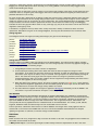
1
home | news | downloads | database notes | articles | weather | links
Contents
Printable pdf version of the Database Notes
Description of fields continued
Introduction
Summary of lists
Classification codes
Discrepancies
Height and Grid Reference
Background to the lists
Great Britain
Revisions to the lists
Ireland
Change registers
Channel Islands
Munros
Col Height, Col Grid Reference and Drop
Corbetts
Grid Ref 10
Grahams
Submitting GPS measurements
Marilyns
Feature, Observations
Humps
Survey
Sims, Murdos, Corbett Tops, Graham Tops and
Hewitts
County Top
Nuttalls
Comments
Deweys
Tumps
Revision
Streetmap/OSi, Hill-bagging,
Geograph/MountainViews
Change Control Database
xcoord, ycoord
GPS Database
Latitude, Longitude
Definitions
GridrefXY
Deleted Tops
_Section
Subs
MVNumber
Description of fields
The Access database
Hill Number, Hill Name
Uploading grid references to a GPS
Parent Name, Parent Number, Parent Sort
Recreating the original lists (Excel/csv file users)
Section, Section name
User feedback and database enhancements
Area
The survey fund
Island
Acknowledgements
County
Topo Region
Changes and issues
in RHB Section order
Scotland
Wales
Beinn a'Chroin (2925, 1C), Beinn a'Chroin East Top (36,
1C) and Beinn a'Chroin West Top (37, 1C)
Craig Fach (2032, 30B) and Mynydd Graig Goch
(2033, 30B)
An Dun (399/400, 5)
Mynydd y Cwm (2051, 30C)
Fiacaill na Leth-choin (560, 8A)
Mynydd Ceiswyn (3431, 30F) and Domen-ddu (3466,
31B)
Carn Liath (595, 8B) and Creag an Dail Bheag (596, 8B)
Corrieyairack Hill (632, 9B)
Rhiw Gwraid (2196/2197, 31B)
Beinn a'Chaorainn (663/665, 9C)
Fan Brycheiniog (2230/5603, 32A)
The Saddle [Trig Point] (686, 10A) and The Saddle (688,
10A)
Garth Hill (7675, 32C)
The Saddle West Top (696, 10A)
The Saddle North Top [1921: Sgurr na Creige] (706, 10A)
Buidhe Bheinn (713/715, 10A) and Sgurr a'Bhac Chaolais
(716, 10A)
Mynydd y Grug (5273, 32C)
England
Housedon Hill (2318, 33)
Armboth Fell (2483/3761, 34B)
Beinn Aoidhdailean (4267, 10A) and Sgurr Mor Near West
Top (4270, 10A)
Wether Hill (2557/2927, 34C)
Sgurr nan Ceannaichean (900, 12A)
Beinn a'Chlaidheimh (1024, 14A)
Wallow Crag [nameless - Naddle Horseshoe 2] (3329,
34C)
Beinn Dearg North Top (3267,15A)
Great Yarlside (3661/2575, 34C)
Foinaven (1124, 16B)
Arnside Knott (3321, 34D)
Knight's Peak (1261, 17B)
nameless (Top o'Selside - Brock Barrow) (3335, 34D)
Meikle Millyea (1693/1694, 27B)
Burnhope Seat (2714, 35A)
Troweir Hill (1734, 27B) and Saugh Hill (5636, 27B)
Thack Moor (2770, 35A)
Channel Islands
Alderney Airport, NE perimeter (7816, 57)
Les Platons, Jersey (7817, 57)
Ireland
Crocknasmug (20445, 45A) and Crockaulin (20886, 45A)
Bunnanimma (20656, 56A)
Baystones [Wansfell] (2607/3838, 34C)
Hand Lake (3608, 35A) and Linghaw (3609, 35A)
Calf Top (2797, 35B)
Birks Fell (2799, 35B)
Raw Head (2828, 36)
Viking Way (5466, 37)
Milk Hill (2872, 39)
Botley Hill (2910/3686, 42)
Introduction
The Database of British and Irish Hills (DoBIH) was founded in 2001. Its twin objectives are to present the most
accurate hill data for lists that meet our criteria of notability and demand, and to provide logging facilities for baggers.
The evolution of the database can be followed in a series of Marhofn articles. The editorial team (in order of joining)
comprises Graham Jackson, Chris Crocker, John Barnard, Simon Edwardes, George Gradwell, Mark Jackson and
Jim Bloomer.
The database is provided in two principal formats: an Access database, from which Excel and csv versions are
derived, and an online database accessible at Hill Bagging. Both formats offer logging facilities, with personal ascent
records readily transferable between the two. Hill Bagging does not return the fields with absolute grid reference,
latitude/longitude (except by reading off the map) or revision date, but includes links to photographs on the hill
summits website. Hill Bagging is continuously updated with changes to lists and data and is therefore the most up to
date. New versions of the downloadable database are currently issued at roughly 4 month intervals. Significant
changes to hill lists (except Tumps below 500m) between releases are communicated via newsflashes on this site.
Such changes, including minor Tumps, are also announced on Hill Bagging when they enter the database.
We place no restrictions on use of our data by third parties and enourage authors of other websites and applications
to do so. We just ask users to observe the terms of the Creative Commons licence.
Discrepancies
Many hills occur in more than one list, which may give different data in the original sources. Where list authors
appear to have chosen different locations for the summit, we have recorded this in the database. In cases where the
locations could be regarded as separate summits we have listed the hills separately. This can be a subjective
decision; we hope the majority of users will agree with our choices. Occasionally a list author's classification is at
odds with our data; these are tabulated in a list of discrepancies.
If you find any errors or wish to query any of the data, please email the authors at the address on the home page.
Summary of lists
The following table summarises the main lists included in the database. It excludes subs, Marilyn and Hump Twin
Tops and a few historic and subjective lists (Bridge, Buxton & Lewis, Dillon, Trail 100). More information on the
individual lists is given in Definitions and Background.
Some lists are subsets of other lists. For example, the Marilyns are a subset of the Humps, the Grahams are a
subset of the Marilyns, and many lists are subsets of the Tumps. Some lists are not exact subsets due to
discrepancies between lists.
National lists
Height
feet 1
Height
metres
Drop
metres
Scotland
England and
Wales
Ireland
any
150+
Marilyn
Marilyn
Marilyn
any
100+
Hump
Hump
Hump
any
30+
Tump
Tump
3000+
914.4+
undefined
Munro, Munro Top Furth
3000+
914.4+
30+
Murdo
2500-2999
762.0-914.3
152.4+ (500ft)2
Corbett
2500-2999
762.0-914.3
30+
Corbett Top3
2000-2499
609.6-761.9
150+
Graham
2000-2499
609.6-761.9
30+
Graham Top3
600+
30+
Sim
609.6+
15+
600+
15+
500-609.5
30+
500+
30+
Arderin
400-499.9
30+
Carn
100-399.9
100+
2000+
n/a
n/a
n/a
see5
Furth
Hewitt
Hewitt
Sim
Sim
Nuttall
Vandeleur-Lynam
Donald Dewey
Highland Five
Dewey
Myrddyn Dewey
Binnion
County Tops 4
SIBs
1
For lists where the current or original definition is expressed in feet
There is one hill (no. 1691) within this height range having a drop between 150 and 152.4m
3 These categories have been superseded by the Sims
4 See County Tops for subsets
5 Islands having at least 30m drop or 30 hectares area excluding sea stacks; see SIBs
2
The Isle of Man is included in the listings of British Marilyns, Humps, Tumps and Deweys, but not in Sims, Hewitts,
Nuttalls or SIBs. Some older lists of British 2000ft hills, including Bridge and Buxton & Lewis, include Snaefell on the
Isle of Man.
The Channel Islands are included in the British Humps and Tumps.
Regional lists
Height
feet
Height
metres
Drop
metres
Region
List
2000+
609.6+
30.48+ (100ft)1
Southern Uplands
Donald
2000+
609.6+
30.48+ (100ft)2
Southern Uplands
Donald Top
1000+ 3
304.8+ 3
undefined
Lake District
Wainwright
undefined
undefined
undefined
Lake District
Wainwright Outlying
Fell
1000+
304.8+
undefined
Lake District
Birkett
300+ 3
undefined
Lake District
Synge
undefined
undefined
Lake District
Fellranger
undefined
1
1
As for Donald Tops but more than 17 units from the main top of the 'Hill' to which it belongs, where a unit is either one-twelfth of a
mile measured along the connecting ridge or one 50-foot contour between the lower Top and its connecting col
2 Plus peaks of sufficient topographical merit between 50ft and 100ft
3 Except Castle Crag
Background to the lists
The first list of British hills to gain popularity, of Scottish mountains over 3000 feet high, was compiled by Sir Hugh
Munro in 1891. The Munros were joined by the Corbetts and Donalds and became well known thanks to their
publication in Munro's Tables. It took a surprisingly long time for a definitive list of Scottish hills in the range 20002500 feet to appear, but in the 1997 edition of Munro's Tables the SMC adopted the list of Grahams that Alan
Dawson had published in 1992. Of Dawson's other Scottish lists, the Murdos (1995) and the New Donalds (1995)
were motivated by a desire to bring objectivity to the classification of Munro Tops and Donalds. Breaking new ground
was Corbett Tops and Corbetteers (1999). Corbett Tops include subsidiary summits of Munros and Corbetts within
the Corbett height range. This was followed by Graham Tops and Grahamists (2004). This last list subsumes the
New Donalds. The last four publications, and three similar ones listing the Hewitts of England, Wales and Ireland,
were published by TACit Press but the majority are now out of print. In June 2010 Dawson created the Sims (Sixhundred Metre Summits) by combining the Murdos, Corbett Tops, Graham Tops and Hewitts and lowering the height
theshold to 600m. The Sims Hall of Fame requires the ascent of 2000 British Sims.
Completions of the Munros (with Tops and Furths) are recorded by the SMC. The SMC also records completions of
Corbetts, Grahams and Donalds by those who have completed the Munros. Completions of Corbetts are recorded by
Dave Hewitt. Completions of Grahams and Sims are recorded by Alan Dawson in the Marilyn News Centre.
Outside Scotland, the Hewitts (Hills in England, Wales and Ireland over Two Thousand feet high), together with the
Nuttalls in England and Wales, are the most accurate and up-to-date of a succession of publications listing the 2000foot summits. In Ireland, a popular list in recent years is The Mountains of Ireland by Paddy Dillon. A listing of Irish
hills equivalent to the Nuttalls was superseded in 1997 by a metric equivalent, the Vandeleur-Lynams. Some of the
earlier lists are of historical interest but for practical use most people will have little reason to look beyond those
mentioned above. However we acceded to requests to include Buxton & Lewis (1986) and Bridge (1973). The last two
lists are defined by the original publication and are not subject to revision. The lists of Elmslie, Simpson and Moss
have been republished online by Moss.
Completions of the English, Welsh and Irish 2000-foot hills are recognised by the Long Distance Walkers Association
(LDWA). It might be thought unreasonable to treat England and Wales as one country, but only The Nuttalls will
record completions of one list without the other.
The first publication to list the 500m tops of England and Wales was Michael Dewey's Mountain Tables in 1995. They
effectively extend the Hewitts down to 500m. Completions are recorded by the LDWA. The Deweys were extended to
Ireland (the Myrddyn Deweys) by Michael Dewey and Myrddyn Phillips in 2000, and to the Scottish Lowlands (Donald
Deweys) by David Purchase in 2001. Hitherto, 500m hills in the Scottish Highlands have not had a separate identity,
but a complete listing of Scottish 500m hills was compiled by Rob Woodall using data from Tony Payne, Clem
Clements, John Kirk and others and uploaded to the rhb group (2003, revised 2006). To distinguish the Highland hills
from the Donald Deweys in searches etc. we have named them Highland Fives. All the 500m lists have been
comprehensively revised since their original publication.
In Ireland, MountainViews has built on data from other sources to create the Arderins for hills over 500m high and the
Carns for hills in the 400–500m range.
The Marilyns was the first list with a criterion on drop alone, and none on height. Published by Alan Dawson in The
Relative Hills of Britain in 1992, the Marilyns quickly attracted the interest of serious baggers. Marilynists' interests
are covered by a website, an e-group, a newsletter and an annual meet. Due to the inaccessibility of the St Kilda sea
stacs it took 22 years for the list to be completed, a feat achieved by Rob Woodall and Eddie Dealtry on 13 October
2014. The Marilyn Hall of Fame is open to those who have climbed 600 Marilyns. The Marilyns were extended to
Ireland by Clem Clements in The Hewitts and Marilyns of Ireland in 1997.
Marilyns have a drop (minimum descent before ascending to higher ground; also known as relative height or
prominence) of at least 150m. They were supplemented in 2007 with the Humps (Hundred Metre Prominence) which
reduces the minimum drop to 100m. The list was compiled by Mark Jackson from a large number of sources and
published online in More Relative Hills of Britain. There are almost 3000 British Humps, including three in the Channel
Islands. There are more than 800 Humps in Ireland; the first complete listing was produced by Jim Bloomer in 2011.
Background to the Humps project is given in Hill Bagging. By analogy with the Marilyn Hall of Fame, Mark Jackson
created the Humps Hall of Fame, requiring 1200 ascents of British Humps.
The Tumps (Thirty & Upward Metre Prominences) comprise all the hills of Britain with 30m or more of drop, with no
minimum height. Thus it incorporates a number of other hill lists, and naturally owes its existence to many
contributors over several years. The Sims, Deweys, Donald Deweys and Highland Fives comprise the portion of the
Tumps above 500 metres. The hills between 300 and 500 metres were first listed by Clem Clements. His work,
though never published, was made available to the rhb community, which paved the way for a complete listing of
Tumps to be released by Mark Jackson in 2009, upon finishing three years of on-and-off research into the c.8,000
hills below 300 metres. The original list was subsequently revised using data from Myrddyn Phillips' independently
compiled lists of English and Welsh hills below 500 metres (the Pedwars, Fours, lower Welsh P30s and subs). The
Tumps comprise over 16,000 hills and have been greeted by a mixture of enthusiastic bagging and the feeling that
this is all a bit much. Andrew Tibbetts maintained and improved the list and in December 2011 released an Excel file
containing the 10,000-odd hills not present in the DoBIH. This file became the P30 Appendix to the DoBIH in May
2013. It went through two revisions before being brought into the DoBIH in version 14.
Walkers who have climbed 2,000 Tumps are eligible to join the Tump Hall of Fame. A list of members is available in
the Files section of the rhb group under Hills of Britain. The Tump Forum is on Google Groups. The Tump Forum and
TumpHoF are maintained by Adrian Rayner. For data queries or corrections to the Tumps please email both Mark
Jackson and Jim Bloomer.
Such is the popularity of the English Lake District that a number of lists have emerged specifically for that region.
The best known is the Wainwrights, which was almost certainly not conceived as a list. The Birketts is a more recent
listing of Lake District Hills. The Wainwright Outlying Fells and the Birketts were each published as a set of walks
rather than a list, but as with the Wainwrights, a tradition of climbing them has developed. The Synges is a longer list
of Lakeland hills. The most recent list is the Fellrangers, which resemble an updated Wainwright. The LDWA
recognises completions of all these lists except the Synges.
The County Tops of England and Wales were first listed by Moss in 1951. Other listings appeared from 1973
onwards, including coverage of Scotland and Ireland in 1985. In Britain, the frequent local government reorganisations
have caused lists based on administrative boundaries to become quickly out of date, and some walkers may prefer
to ascend the highest points of the historic counties. Simon Edwardes overhauled the county tops for the Hill
Bagging website and produced lists based on both historic and administrative boundaries. These lists are given in the
database and are the most up-to-date available. The LDWA records completions of County Tops in England, Wales
and Ireland but not Scotland.
A recent phenomenon has been the growing interest in bagging island summits. The Scottish Islands by Hamish
Haswell-Smith includes the larger islands (minimum area 40ha) and has been used by some walkers to provide
bagging objectives. This is an useful book but is perhaps targeted more at yachtsmen, as the criteria for island
status are unintuitive from a hillwalker's perspective (it must be reachable only by boat at all tide states, so Skye is
excluded by virtue of the bridge). Rick Livingstone produced an online table of Scottish islands using a 15ha criterion
that is more attuned to hillwalkers but seems to be less well known. In October 2014 Alan Holmes published on the
rhb group the most comprehensive island list to date. It is targeted specifically at hillwalkers, uses both area and
drop criteria, and is the only list to cover the whole of Britain. Baggers are encouraged to report annual totals to Alan
Holmes.
The categorisation of mountains worldwide by prominence is well established. For information visit the Topographic
Prominence and Europeaklist websites and their associated discussion groups. An early US led initiative was to list
hills worldwide with a drop of at least 2000ft (609.6m). Although a register of baggers' totals is maintained by Andy
Martin (and by Rob Woodall for British based walkers), the prominence criterion has been superseded by 500m or
600m in countries outside the US. The Major Mountains of Britain and Ireland have a minimum 600m drop. Hills
having a drop of at least 500m or 600m can be obtained by a search on drop, or by a sort in the Excel version, and
both lists are offered on Hill Bagging. Internationally, 1500m drop has become the accepted standard for the most
prominent mountains and the category is known as the Ultras.
In v11.2 we added the Trail 100, a list of 100 hills published in Trail magazine in 2007 which had become popularised
by becoming the objective of the WaterAid Trail 100 charity challenge. The list includes one Irish hill, Slieve Donard
in the Mournes. The charity event was not repeated after 2008 and 2009, but the list is still referenced in Trail.
Revisions to the lists
Most current lists based on height or prominence criteria have been subject to regular revision. Changes can be
broadly classified into the following:
Promotions
Deletions
Replacements
Relocations
Data changes
The last category comprises changes to primary hill data that would not affect a bagger's ascent records, including
small changes in summit location. Such changes are not explicitly mentioned in the database but a change in height,
6-figure GR, drop or col location will trigger a new revision date.
A replacement creates a new hill in the database whereas a relocation does not. With the exception of minor Tumps,
most moves of more than 400m will trigger a replacement, as will lesser moves if the summit has a clearly separate
identity, or if the former summit is retained as a member of a different list (e.g. the former Marilyn summit of Wansfell
is a Birkett).
Our definition of replacement is more liberal than that adopted by the RHB updates (in "Hill changes") or the Appendix
to the Humps e-book (which requires 30m of drop between the original summit and the replacement). This is
necessary in order that a change in location does not invalidate baggers' records, including walkers' logs in Hill
Bagging. For example, Botley Hill, which moved by 1km, clearly justified a new record as many baggers had to
revisit the hill following the change.
In doubtful cases we will create a new hill if there is a fair chance that a bagger of the former summit would not have
visited the new one, recognising that most baggers will make an attempt to locate the highest point when there are
plausible alternatives in the vicinity.
For minor Tumps (hills <500m that do not belong to other lists) we have taken a pragmatic approach due to the large
number of major relocations we were finding during the data review, a consequence of the age of much of the data.
Initially we required a move of at least 5km to merit a replacement. This caused difficulties when the popularity of the
Tumps increased, and we now create a replacement for lesser moves where the number of logs on Hill Bagging
indicates the hill is fairly popular. Where there are only a few logs (say 0-3) we do not create a new hill but inform the
originators of the logs by email.
A relocation is a significant move (at least 100m, usually more) that is worthy of mention but does not merit a
replacement. Relocations are given in the Change Registers, and may also be mentioned in the Comments field.
Change registers
Chronological records of changes (excluding data changes) are given for the following lists.
Munros
The Munros 1891-2013
Corbetts
The Corbetts 1953-2013
Grahams
Changes to the Grahams
Marilyns
Changes to the Marilyns
Humps
Changes to the Humps
Sims
Changes to the Sims, Murdos, Corbett Tops, Graham Tops and Hewitts
Nuttalls
Changes to the Nuttalls
Deweys
Changes to the Deweys
Tumps
Changes to the Tumps
Change Control Database
Changes to data in the DoBIH, other than updates from the GPS database, are made through a publicly viewable
Change Control Database. Only the database editors can raise change requests, but users may propose changes by
email. Changes go through the following stages:
1. Change Request raised. The status is shown as Requested.
2. A consultation period during which other editors will check the data and agree the change or make
amendments. In the latter case the status will change to Revised. An editor who disputes the change or has
reservations (who may be the author) can put it On hold. A change request can be cancelled by the original
author. The author will usually agree their own request unless the change is speculative or based on
unchecked third party data. The number of editors who have agreed the change following the latest revision
is shown after (Agree=) on the summary page.
3. When two editors have agreed a change, the colour of (Agree=) changes from red to green. At this point the
change becomes eligible for application, but the consultation period will remain open until all the editors have
had sufficient time to review the change and any debate has ceased.
4. The status becomes Applied. The changes are applied to Hill Bagging immediately and to the DoBIH in the
next release. Any further amendment will require a new change request.
GPS Database
GPS data submitted to the GPS database administrator or logged on Hill Bagging are validated by comparing with
existing records and/or checking on maps, as appropriate. Where a hill has existing data, the new measurement may
replace the original (usually when a survey has revealed a new location to be higher), otherwise the grid reference
input to the DoBIH will be the average of all valid measurements. The 10-figure GR, Feature, Observations and
Survey fields will then be populated from the validated records in the GPS database. The xcoord, ycoord, latitude,
longitude, GridRefXY fields and derived map links are recalculated from the new GR.
Prior to April 2015, submissions were stored in an offline database and changes were usually applied en bloc to
coincide with a new release of the DoBIH. We now use an online GPS database that facilitates more frequent
updating and provides an audit trail, as with the Change Control Database.
Definitions
Marilyns
British and Irish hills of any height with a drop of at least 150 metres on all sides. The geographical area includes the
Isle of Man and the islands of St Kilda.
A Marilyn Twin Top is a summit of equal height to another Marilyn where the drop between the two is less than
150m and (as of March 2010) at least 30m. There are two examples, 313 Stob Coire a'Chairn in Scotland and 21168
Knockalla Mountain NE Top in Ireland.
Cruachan Dearg, Meall nan Damh, Sidhean a'Choin Bhain (formerly twin Grahams), Cnoc Coir a'Phuill, Sgurr a'Bhac
Chaolais, Middleton Hill, An Stuc, Carn Liath and Saugh Hill were formerly twin Marilyns.
Many hills have alternative summit locations of apparently equal height that fail to qualify as Twin Tops. Examples of
such hills feature in the RHB update sheets. For historical reasons a few of these summits have separate entries in
the database. For other hills, alternative high points are noted in the Observations or the Comments field. It is left to
the walker to decide whether all such points should be visited; on some hills there are many candidates for the
highest point and the exercise could degenerate into pedantry.
Humps
British and Irish Hills of any height with a drop of at least 100 metres or more on all sides. The name Hump stands
for Hundred Metre Prominence. As all Marilyns qualify as Humps, the classification code Hu is only used for nonMarilyns; however all Humps are returned in searches. The geographical area was extended to the Channel Islands in
November 2011.
A Twin Hump is defined as a summit of equal height to another Hump where the drop between the two summits is at
least 30m but less than 100m.
Tumps
British hills of any height with at least 30m of drop. The geographical area was extended to the Channel Islands in
September 2014.
A Twin Tump is defined as a summit of equal height to another Tump separated by a distance of at least 5km where
the drop between the two summits is less than 30m. There is currently one Twin Tump.
Sims
Hills in Britain and Ireland at least 600 metres high with a drop of at least 30 metres on all sides. The British Sims is
the subset of Tumps in Scotland, England and Wales at least 600m high and was created by its author to replace the
Murdos, Corbett Tops, Graham Tops and Hewitts. We have extended the Sims to the Isle of Man (one summit) and
Ireland.
Munros
Scottish hills at least 3000 feet in height regarded by the SMC as distinct and separate mountains, based on a list
originally published in 1891. Subsidiary summits meeting the height criterion are designated Munro Tops; note
however that the 'Tops' as defined in Munro's Tables includes the Munros. Summits equivalent to the Munros and
Tops in England, Wales and Ireland on the SMC's list are known as Furths.
Murdos
Scottish hills at least 3000 feet in height with a drop of at least 30 metres on all sides. All Murdos are Munros or
Munro Tops but some Munro Tops fail to qualify as Murdos.
Corbetts
Scottish hills between 2500 and 2999 feet high with a drop of at least 500 feet (152.4m) on all sides.
Corbett Tops
Scottish hills between 2500 and 2999 feet high with a drop of at least 30 metres on all sides. The TACit publication
divides them into three sub-categories: Corbetts, Corbett Tops of Munros, and Corbett Tops of Corbetts.
Grahams
Scottish hills between 2000 and 2499 feet high with a drop of at least 150 metres on all sides.
Graham Tops
Scottish hills between 2000 and 2499 feet high with a drop of at least 30 metres on all sides. The TACit publication
divides them into five sub-categories: Grahams, Graham Tops of Munros, Graham Tops of Corbetts, Graham Tops of
Grahams, and Graham Tops of Hewitts (one hill).
Donalds
Hills in the Scottish Lowlands at least 2000 feet high. 'Tops' are all elevations with a drop of at least 100 feet
(30.48m) on all sides and elevations of sufficient topographical merit with a drop of between 50 and 100 feet. Certain
of these are designated 'Hills' according to a formula based on both distance and drop: see the footnote to the second
table in Summary of lists.
A related list is Dawson's New Donalds, not given here, in which the qualifying criterion is simplified to 30 metres of
drop. The New Donalds are a subset of the Graham Tops. Anyone who has completed the Donalds and Donald Tops
will have visited all the New Donalds.
Hewitts
Hills in England, Wales and Ireland at least 2000 feet high with a drop of at least 30 metres on all sides.
Nuttalls
Hills in England and Wales at least 2000 feet high with a drop of at least 15 metres on all sides, as published in The
Mountains of England and Wales. The list includes 127 summits that do not qualify as Hewitts. Particularly notable is
Pillar Rock as its ascent by the easiest route is a Moderate rock climb or Grade 3 scramble. Many of these additional
summits, including Pillar Rock, also feature in Bridge's and Buxton & Lewis's lists. Completions without Pillar Rock
are accepted by the LDWA and the Nuttalls, though this is noted in the record.
Vandeleur-Lynams
Hills in Ireland at least 600 metres high with a drop of at least 15 metres on all sides. In 1952 Joss Lynam produced
a list of 2000ft summits with 50ft drop with assistance from Rev C R P Vandeleur. Joss Lynam updated a version of
this list and published it in a reprint of "Mountaineering in Ireland" by Claude Wall printed in 1976. The metric
equivalent was published in 1997. Lynam was actively involved with the list until 2002, thereafter assisting
MountainViews with subsequent revisions until his death in 2011.
Dillons
Hills in Ireland at least 2000 feet high published in The Mountains of Ireland. There is no prominence criterion. 15
Dillons are not Hewitts; 14 have drop <30m, while 20213 Corcog has a 609m spot height (the old 1:10560 map shows
2012ft which converts to 610.6m on the new datum). 12 Hewitts are not Dillons.
Deweys
Hills in England, Wales and the Isle of Man at least 500m high and below 609.6m with a drop of at least 30m on all
sides. Equivalent lists in other geographical areas are the Donald Deweys in the Scottish Lowlands, the Highland
Fives in the Scottish Highlands, and the Myrddyn Deweys in Ireland.
The most awkward Dewey is Great Links Tor, which even with the aid of a ladder to gain the crag presents difficulties
on wet rock. A completion without Great Links Tor is accepted by the LDWA, though this is noted.
Arderins
Hills in Ireland at least 500 metres high with a drop of at least 30m on all sides. The list was compiled in 2002 by
Simon Stewart in MountainViews and named in 2009. The name comes from the 527m hill which is the County Top
for both Laois and Offaly and means, from the Irish, "Height of Ireland". In principle the list amalgamates the Irish
Hewitts and Myrddyn Deweys, but there are some differences due to use of a different data source.
Carns
Hills in Ireland between 400 and 499.9m high with a drop of at least 30m on all sides as defined by MountainViews,
based on a list originally supplied to the Mountaineering Council of Ireland by Myrddyn Phillips. The name comes
from Carn Hill, Cnoc an Chairn, "hill of the cairn" in the Sperrins. We have overhauled the data using current and old
maps and produced an updated listing identified with the classification code 4. The MountainViews list can be
obtained in searches via the code Ca. Differences between the two lists have been tabulated.
Binnions
Hills in Ireland with height below 400m and a drop of at least 100m on all sides. The list is a subset of the Humps
apart from one hill; see discrepancies.
Wainwrights
The 214 hills listed in volumes 1-7 of Wainwright's A Pictorial Guide to the Lakeland Fells.
Wainwright Outlying Fells
Hills listed in The Outlying Fells of Lakeland. A previously published source of data is New Combined Indexes to A.
Wainwright's Pictorial Guides, John M Turner, Second Edition (1984), Lingdales Press. This list has many
inaccuracies. Not least, it is short of two summits explicitly mentioned in Wainwright's book (Caermote Hill, for which
the author gives the location of St John's Hill; and the southern summit of Newton Fell) and it also omits the 12
nameless summits. In version 6 we overhauled the entire list using the latest 1:25000 maps and where necessary,
older metric and imperial maps. The assistance of correspondents is gratefully acknowledged.
For a good many hills the summit location is not the highest ground in the vicinity. This is often due to Wainwright's
preference for a recognisable feature such as a cairn (which may have disappeared). It is not always straightforward
to identify such locations on the map, but most are now resolved following site visits.
The list at the back of Wainwright's book contains 110 named fells and summits. Close inspection shows seven of
them to refer to other hills in the list, while Newton Fell has two summits. Thus:
Cartmel Fell is the same as Ravens Barrow (page 42)
Hollow Moor is the summit of Green Quarter Fell (page 14)
Hooker Crag is the summit of Muncaster fell (page 186)
Newton Fell includes Newton Fell (North) and Newton Fell (South) (page 53)
Potter Fell is the name given to the hill whose summits are Brunt Knotts and Ulgraves (page 8)
Lord's Seat is the summit of Whitbarrow (page 36)
Williamson's Monument is the same as High Knott (page 18)
Woodland Fell is the name of the moor of which Yew Bank and Wool Knott are high points (page 102).
The addition of the 12 nameless summits brings the total number of Wainwright Outlying Fells to 116, 14 more than
in Turner's list.
Birketts
Lake District hills over 1,000ft listed in Bill Birkett's Complete Lakeland Fells.
Synges
Lake District hills over 1,000ft published in Tim Synges's The Lakeland Summits (1995, out of print). The book aims
to list every significant summit over 300 metres in height within the National Park, including the 214 hills in
Wainwright's Pictorial Guides. Distinctions are made between summits above or below 600 metres, between
mountains (drop at least 30m) and tops, and between Wainwrights and non-Wainwrights.
Fellrangers
Lake District hills included in Mark Richards' Fellranger walking series, a set of eight volumes inspired by the
Wainwright guides.
County Tops
The highest point within (or sometimes on) the boundary of each county.
County boundaries change over time. There are different county lists, covering the traditional historic counties and
the more recent mixtures of administrative areas.
We provide three separate lists of county tops that we believe are the most commonly used in the pursuit of county
top bagging:
Historic County tops — traditional list of counties from which people usually take their local cultural identity. In the
UK they were never abolished, they just ceased to have administrative function. In the Republic of Ireland, most of
the original counties are still real and important.
Administrative County tops — incorporating the redrawn administrative boundaries and introduction of Metropolitan
Counties in the mid 1970s. These began to be abolished in the 1990s.
Current County and Unitary Authority tops — list of Counties, Metropolitan Districts and Unitary Authorities that
came into existence in the 1990s, and are still changing. Included are the 11 local government districts of Northern
Ireland, together with four City Councils in the Republic of Ireland and three new counties that emerged from the
historic 'Dublin'.
For completeness, we have also provided a list of London Borough tops. In terms of administrative tier, these are at
the same level as Metropolitan Districts.
Twin tops are listed for some County Tops.
For further information on British county history, see Hill Bagging (England and Wales), Hill Bagging (Scotland).
SIBs
The Significant Islands of Britain are defined as naturally occuring land which at MHWS is completely surrounded by
water with either an area of at least 10 hectares within the MHWS contour line or a prominence of at least 30 metres
above MSL, or both, all man-made links and structures being discounted. They were researched by Alan Holmes who
made his list available to members of the rhb group on 30 October 2014.
The source file divides the SIBs into categories of Main SIBs, B-SIBs and V-SIBs, with a further SIBLET category of
islands that do not qualify but may be of interest to trippers. The list offered by the DoBIH contains only the Main
SIBs, comprising all islands having an area of at least 30 hectares or a drop of at least 30 metres, excluding sea
stacks, as we believe this category is of most interest to baggers. It is also the category relevant to achieving the
three levels of membership of the author's SIB Ship. For convenience we drop the "Main" in the database.
Deleted Tops
Sometimes a hill that once appeared on a list is later removed. In the past the most common cause was remapping,
though many Munro Tops were deleted on subjective grounds. Since 2006, many deletions have resulted from
surveys, and some list authors will not delete a hill without one.
All deleted tops are present in the database, but only deletions in the SMC lists, the Grahams which have been
adopted by the SMC but are not owned by them, and deleted Nuttalls are identified by a classification code. For other
hill categories, the deletion is usually recorded in the Comments field, at least while the deletion is relatively recent.
The deletion categories are:
Deleted Munro Tops (xMT). Includes the deleted Munros, Beinn an Lochain, Sgurr nan Ceannaichean and Beinn
a'Chlaidheimh.
Deleted Corbetts (xC). Includes Beinn Teallach which was promoted to Munro.
Deleted Grahams (xG). Three deletions plus a relocation.
Deleted Donald Tops (xDT). Includes the hills in Section 13—Appendix in the 1990 and earlier editions of Munro's
Tables, and deleted Donalds (currently only the original location of Meikle Millyea).
Deleted Nuttalls (xN). Comprises the summits described as such by the Nuttalls. Most are not true deletions,
being candidates for the list that were rejected in advance of the publication.
All deletions at any time in a list's history are identified. Thus the xMT category includes all deletions from 1921
onwards. Details of specific changes to Munros and Munro Tops through the different editions of Munro's Tables are
given in The Munros: 1891-2013. A similar table for the Corbetts is given in The Corbetts 1953-2013. Change
registers are provided for other popular hill lists.
Subs
"Subs" are hills in certain prominence based lists falling short on drop by 10m or less. The term originated in the
TACit Tables published from 1995 onwards and the principle has been adopted by other list authors. The database
lists subs of Marilyns, Humps, Sims, Deweys, Donald Deweys, Myrddyn Deweys, Highland Fives and 490-499m
hills.
In the TACit booklets the "sub" categories include hills falling short on height, and there are additional categories for
Subcorbetts and Subgrahams. The new definitions appeared in Marhofn in May 2006. The rationale for the change
was explained in an rhb group message.
The statistical error associated with heights on OS maps means that some marginals have a non-negligible
probability of qualifying for a list. Serious baggers who wish to legitimately claim ascent of all hills meeting the list
criteria will need to climb some subs, in addition to hills falling short on height. As a rough guide, for hills whose
height and drop have not been accurately measured by surveying you should climb those within 3m of the qualifying
height and 4m of drop. If you are interested in the English 2000s you should also climb Calf Top as the surveying
error exceeds the shortfall on height. For further information see Allowing for measurement error. It would be wrong,
incidentally, to assume that hills falling short on both height and drop have an insignificant probability of qualification.
A change in summit height will often induce a corresponding change in drop. Birks Fell was at one time a
Doublesubhewitt (in the old classification) with height 608m and drop 29m.
Description of fields
The headings below are approximately in the order in which the columns appear in the Excel version.
The following abbreviations are used when referring to sources:
RHB=The Relative Hills of Britain; TACit=TACit Tables. Significant changes to Marilyns since RHB's publication in
1992 are summarised in update sheets every few years that can be found on the Marilyn News Centre. The TACit
Tables have not been updated, apart from The Grahams and the New Donalds in 1999, and the lists given in those
publications have been subsumed into the Sims.
Hill Number
A unique hill identifier to assist with revision and help users raise queries with the authors. The hill number will not be
changed during the lifetime of the database unless it is unavoidable; such rare events will be well publicised. To
upgrade non-Access versions, sort the old and new releases by hill number and copy and paste your personal ascent
records from one to the other.
Hill Name
The name(s) by which the hill generally appears in lists and maps. If this varies, we usually prefer the name most
compatible with current OS mapping unless another name is particularly well known. Alternative names are given in
square brackets. Qualifiers are enclosed in round brackets.
For some multi-topped hills e.g. Liathach and Quinag, the SMC gives both names. For Munros and Corbetts, the
Name field gives the two names separated by a hyphen. This allows users to search the database on either name.
For Tops of Munros and Corbetts we only give the summit name as the range name will appear in the Parent field.
We have followed the same convention for a few non-SMC hills where the summit has a different name from the hill,
usually when the original list gives both e.g. Birnam Hill - King's Seat.
Where a Scots Gaelic name has an apostrophe, our convention is not to use a trailing space. Thus we give Stuc
a'Chroin rather than Stuc a' Chroin. However where a' is a contraction (for hills this is usually a contraction of "an") it
is correct to insert a space, and the OS generally does so. Our usage aligns with RHB, the TACit Tables and most
hill names in Munro's Tables, and as we have followed this convention since v1 we believe that maintaining our
current practice is the least confusing for users.
To facilitate searching, accents appearing in Gaelic and Welsh names have been removed.
Irish hill names are taken from MountainViews and Clements' TACit Tables. For British hills we try to include all
names appearing in maps and lists that users are likely to search on, even if incorrect.
Parent (Ma/M)
The Munro or Marilyn to which the col of lesser hills is linked. For Munro Tops, Corbett Tops etc. it replaces the hill
name that prefixed the summit name in old versions of the database. The field also identifies lower children of the
same parents, and children of lower Marilyns. There are no parents of parents.
'none' indicates a non-Marilyn with no parent. Such hills will lie on an island where no hill reaches 150m in height.
Parent Number
The hill number of the parent. 0 corresponds to 'none'.
Parent Sort
Shown in the Excel and csv versions, where it appears to the right of _Section. As Parent Number but with the hill's
own number added for hills that are parents. Thus a filter or sort on this column will return a parent (usually first) and
all its children. An equivalent facility is provided in Access with the "Parent Ma/M" query, accessible from the
Queries menu in the DoBIH_v14.3:Database window. As of v14.3 all hills have now had their parent assigned; in
previous versions of the database an unassigned parent would be blank in the Excel field but -1 in the Access query.
Section
The RHB/TACit Section number. Sections 1-17 correspond to those in Munro's Tables, enlarged to include lesser
hills. In Corbett Tops and Corbetteers (1999) sections 5, 7 and 8 were split for the first time into West (A) and East
(B) sections. Section 26 was subsequently split for the Graham Tops booklet. Note that 10A and 10B in Munro's
Tables do not correspond to 10A and 10B in RHB.
Sections 43-56 apply to Ireland. We have created Section 57 for the Channel Islands.
Subsequent to the publication of RHB, the boundary between Sections 1 and 26 was moved to follow the course of
the Highland Boundary Fault, resulting in some hills being moved from 1B to 26B. The boundary between Sections
10B and 10C was moved eastwards to Loch Blair and the Allt a'Choire Riabhaich. This resulted in Sgurr Mhurlagain
being transferred from 10B in RHB to 10C in Corbett Tops and Corbetteers.
Hills duplicated in more than one section of the RHB/TACit Tables, or which could be put in more than one section,
have been treated as follows:
Black Mountain (2242, Wales)
Formerly listed in RHB/TACit as belonging to both England and Wales. With effect from May 2007, Black Mountain is
deemed to be in Wales only (32A) for the purposes of lists and databases. Black Mountain was always assigned to
Wales in the Nuttalls' list.
Hills on the England-Scotland border
Assigned to Section 33 with the exception of Cairn Hill West Top in 28B. This Donald Top does not appear in English
lists (except as a deleted Nuttall, under the name Hangingstone Hill) as the drop before ascending to Cairn Hill is only
5m. These hills are searchable under both 28B and 33 in the Access database and on Hill Bagging.
Cuilcagh (20137, Ireland)
Assigned to Section 45D by Clements but is on the International border and the 44A/45D boundary. Cuilcagh is
deemed to be in 45D in the Republic of Ireland.
Section name
The name of the RHB/TACit Section.
Area
This field is used principally for the following:
Donald Sections in Munro's Tables
Wainwright volumes
Nuttall book chapters
SIB Regions
Irish hills
Nuttalls and Donalds area names are used for all hills belonging to those lists. This facilitates comparison with the
original lists and will also serve for sorting Wainwrights by volume. For islands, the area name is taken from the
maritime Region set out in The Significant Islands of Britain (SIBs) by Alan Holmes. Within the Irish mainland, most
hills are given the area names in use by MountainViews. Lower hills not belonging to the relevant hill list may not
have had their Area assigned.
A few hills on the Scotland–England border belong to "Cheviots" in the Nuttalls' volume and "Roxburgh and Cheviots"
in the Donalds listing in Munro's Tables. This presents a problem with the Excel and csv versions of the database,
unless one adopts the clumsy solution of giving each list a separate Area field. Furthermore, in version 12 we wished
to assign area names to other Lowland hills and "Roxburgh and Cheviots" is far from ideal. All versions of Munro's
Tables prior to 1997 give two areas, "Roxburgh" (section 11) and "Cheviots" (section 12). The SMC amalgamated the
two regions when they removed Auchope Cairn and the six unnumbered English tops in 1997, leaving only three hills
in total. We decided the simplest solution was to revert to the pre-1997 sections, as "Cheviots" is also the Nuttalls
area name. Accordingly, 1906 Cauldcleuch Head is in "Roxburgh", and 1846 Cairn Hill West Top, 2303 Cairn Hill and
2305 Auchope Cairn are in "Cheviots". There is no conflict between Nuttalls and Wainwrights because the Nuttalls
use the Wainwright volume titles.
For Wainwright Outlying Fells we have extended the areas defined in the Pictorial Guides by continuing the
Windermere boundary southwards along the River Leven to Greenodd, and from Bassenthwaite Lake north-west along
the River Derwent. In England and Wales, Nuttall and Wainwright areas have been assigned to many other hills falling
within their boundaries, with Central Wales subdivided into three regions, but this process is incomplete for the
Tumps. The classification of hills situated between the English Lakes and Yorkshire Dales National Parks will be
reviewed in the event of the proposed boundary extensions going ahead.
In Wales, we needed to define the boundary between the Arans and Berwyns for the hills south of Bala from
Rhiwaedog-uwch-afon (3421) in the north to Mynydd Maes-glas (3424) in the south. The easiest solution would be to
put them all in the Arans or all in the Berwyns. However in the Nuttalls' book, Moel y Cerrig Duon (2116) belongs to
the Arans and Foel y Geifr (2115) and Foel Goch (2123) to the Berwyns. Topographically this is not logical, but the
Nuttalls clearly did so because Moel y Cerrig Duon is conveniently included in the same walk as the hills west of the
road summit. Our solution is to assign those hills south of Moel y Cerrig Duon and south-west of Lake Vyrnwy to the
Arans, and those north of Moel y Cerrig Duon and to the north-east of Lake Vyrnwy in the Berwyns, with the
exception of Moel Eunant (3412) which is a satellite of Moel y Cerrig Duon. We feel this is the best we can do without
breaking the alignment with the Nuttalls' book.
To divide the Arenigs from the Moelwyns we chose to make the boundary Ffestiniog-B4391-B4407. There are other
options but none are demonstrably better. The Moelwyns (as defined by the Nuttalls) span two RHB sections, 30B
and 30D.
Island
The island name is used whenever there are two or more Tumps on an island landmass. For islands that are
connected to higher ground via a landbridge, when the tide is between MHWS and MLWS, (t) is appended to the
island name to indicate 'tidal'. Islands with fewer than two Tumps are in one of four categories: Mono Tump island;
Mono Tump island (t); Non Tump island & Non Tump island (t). Irish islands always show the island name. To search
on this field in Hill Bagging, list the SIBs and then select Hills by Island from the menu on the left.
Topo Region
The geographical area in Mark Jackson's scheme for Humps and Tumps. In Access, the Topo Region is a
searchable option in the Area/Region dropdown box; in the results screen it is given in the bottom row of the
Areas/Regions table.
County
This field is shown in the Excel/csv versions and on Hill Bagging. It gives the Current County or Unitary Authority for
the hill. The Access version does not give the county in the search results but offers a search of all hills by county in
the Areas/Regions dropdown box.
Membership is calculated using the grid reference and pre-programmed polygons approximating the county
boundaries. It may occasionally misassign a hill close to a boundary. Please let us know if you discover an error.
Classification codes
Ma
Hu
Sim
M
MT
F
C
G
D
DT
Mur
CT
GT
Hew
N
5
5D
5H
prefixes
s
x
suffixes
=
Marilyn
Hump
Sim
Munro
Munro Top
Furth
Corbett
Graham
Donald
Donald Top
Murdo
Corbett Top
Graham Top
Hewitt
Nuttall
Dewey
Donald Dewey
Highland Five
sub
deleted
4
3
2
1
0
W
WO
B
CoH
CoU
CoA
CoL
SIB
Dil
A
VL
5M
Sy
Fel
O
Un
400-499m Tump
300-399m Tump (GB)
200-299m Tump (GB)
100-199m Tump (GB)
0-99m Tump (GB)
Wainwright
Wainwright Outlying Fell
Birkett
County Top – Historic
County Top – Current County and Unitary Authority
County Top – Administrative
County Top – London Borough
Significant Island of Britain
Dillon
Arderin
Vandeleur-Lynam
Myrddyn Dewey
Synge
Fellranger
Other list
unclassified
twin
We identify deletions only for SMC lists and Nuttalls. See Deleted Tops and Subs for details of these categories.
Other searchable categories not shown in the classification field are as follows:
B&L
Bg
T100
Buxton & Lewis
Bridge
Trail 100
Tu
Ca
Bin
Tump
Carn
Binnion
The MT, CT and GT codes exclude Munros, Corbetts and Grahams, respectively.
Most unclassified hills are deletions. The rest comprise hills surveyed as falling short of Nuttall status, and a few that
existed on Hill Bagging before the databases were merged in v11.
Height and Grid Reference
Access and Excel have separate fields for 6-figure and 10-figure grid references. As explained below, the former is
intended for use with paper maps and the latter for use with GPS instruments. Hill Bagging has a single field which
gives the 10-figure grid reference if one exists and the 6-figure grid reference followed by (est) otherwise.
The treatment of man-made objects on summits is a contentious issue. The database adheres to the protocol
described in Summits and Cols.
Great Britain
Much of the data originally entered into the database came from 1:10000 maps, as used by Dawson in the TACit
Tables, with the remainder taken from 1:25000 and 1:50000 maps. We now make routine use of the large scale OS
mapping on the Geograph website and very occasionally the vector maps on the OS OpenData website, both of
which show many spot heights absent from the 1:25k and 1:50k maps. This has enabled us to refine many summit
and col heights previously estimated by contour interpolation. All spot heights on the original 1:50000 Landranger
maps are metric conversions of older imperial heights and they are only slowly being replaced. Many of these old
heights were obtained by spirit levelling 100 years or more ago and are more accurate than the air heights on modern
metric maps, but their positions on the map may be approximate and, as with air heights, they are not always at the
summit. For some hills we have taken levelled heights from old 1:10560 or 1:2500 maps, where necessary adjusting
for the change in datum from Liverpool Dock to Newlyn in 1921 (most corrections are <0.3m). All the British hills in
the database have been reviewed using the new online mapping resources, the Tumps being completed in March
2015. As the OS are continually revising their maps, further changes are inevitable.
Spot heights often differ between maps. The largest scale map on Geograph and the OS Openspace vector map are
the most consistent on heights, but very occasionally these differ too. Most discrepancies are 1m. Differences of 3m
or more usually correspond to non-identical locations. The error in air heights from photogrammetry is ±3.3m so it
does not follow that one measurement is right and another wrong; they are just different estimates of the height. We
have found no difference in the accuracy of spot heights displayed at different map scales, so there is no reason to
prefer the larger scale maps.
We now have 10-figure grid references from GPS measurements for most hills in the popular lists. As described
below, we use these to derive the 6-figure grid reference. For a growing number of hills we have accurate height
measurements from differential GPS. Other published lists may give different data. One reason why grid references
can vary is that authors do not measure them in the same way. By convention, a 6-figure OS Grid Reference is the
address of the 100m square in which the feature lies. This is given by the co-ordinates of the south-west corner of
the square (the same rule applies however many digits you quote). For example, the trig point of Great Shunner Fell
is located at SD 84862 97290 so the correct 6-figure grid reference is SD848972. TACit Tables comply with this
convention but many list authors round to the nearest 100m instead; in the above example they would give
SD849973. Another reason for published grid references not matching ours is that the true summit may not be
identified on the map; there are many examples in the database where a spot height or trig pillar is not at the highest
point.
Before truncating the entry in the 10-figure grid reference field to create the 6-figure GR, we make a small adjustment
to correct for systematic error in the GPS readout (see below). This ensures that 6-figure grid references and xcoord,
ycoord values are to the OSGB36 datum.
For Wainwrights the author sometimes gives a summit location that is not the highest point of the fell. This is
particularly true of the Outlying Fells. Our policy is to take the location intended by Wainwright. We have followed the
same policy with Birketts. Where there is a conflict between the location implied in the text and the grid reference in
Birkett's book we prefer the former, as we understand the GRs were added later by a different author. Any doubtful
cases are mentioned in the Comments field.
Metric heights are converted to feet using a factor of 1/0.3048.
Ireland
Irish data are primarily from 1:50000 2009 digital mapping supplied by OSi and OSNI. Heights surveyed by
MountainViews are used where available. Reference to 1:25000 mapping has been possible in the Mournes and
MacGillycuddy's Reeks. All these maps offer very few spot heights at cols. Harvey maps have provided some col
heights in the Dunkerron Mountains, Maamturks, MacGillycuddy's Reeks, Mangerton, Purple Mountain, Twelve Bens
and Dublin/Wicklow areas. For a small number of hills we consulted historic 1:10560 maps to obtain additional
heights and to resolve the 21093/21094 twins.
Vertical heights on current mapping are relative to mean sea level at Malin Head. Earlier maps, e.g. the half-inch
maps and the 1:63360 District Maps, use the low water mark of the spring tide on 8 April 1837 at Poolbeg
Lighthouse, Dublin. The Malin Head datum is approximately 2.7m above the Poolbeg Lighthouse datum.
Channel Islands
Data are taken from Ministry of Defence maps at 1:25000, 1:10560 or 1:10000 scale based largely on 1960s surveys,
supplemented by the States of Jersey Official Leisure Map (1:25000) and the States of Guernsey Official Map
(1:15000, with 1:10000 coverage of Alderney, Herm, Jethou, Sark and Brecqhou on the reverse). The latter maps are
published by Digimap, the official mapping agency for the Channel Islands. The older maps show many more spot
heights than the recent maps. Admiralty charts were also consulted. Note that the vertical datum for the latter is
MHWS rather than MSL and heights are quoted to the top of buildings rather than the ground.
Grid references are for UTM zone 30U and use the WGS84 datum. This grid is shown on the two "Official" paper
maps although it is not the primary grid on the States of Guernsey Official Map, which uses the Guernsey Grid. The
grid letters are WA for Alderney and WV for the other islands. Older maps use the ED50 European datum. The two
datums give a difference of about 300 metres in grid reference. The extracts from the MoD maps published in the
Sunflower guides, and some modern maps such as the 1:12500 International Travel Map of Guernsey and the
smaller islands, use the older coordinate system so please bear this in mind when using the data. To avoid potential
problems we recommend using latitude/longitude with third party applications.
Garmin GPS instruments use the WGS84 datum by default when set to UTM/UPS grid but return the absolute
coordinates (shown in the xcoord, ycoord fields) rather than the lettered GRs. The same is true of GPS Utility. GPS
Utility also offers the new Guernsey Grid.
There is also a new Jersey Grid, whose parameters can be found in a web search on "Jersey Transverse Mercator".
This grid does not appear on the States of Jersey Official Leisure Map.
We are grateful to David Purchase for researching the maps and providing the data.
Col Height, Col Grid Reference and Drop
Drop, also known as relative height in Britain and Ireland and prominence in the US, is defined as the height
difference in metres between the summit and the col connecting the hill to a higher summit. Where there is more than
one such col, the highest is chosen.
Cols are usually much less well defined than the summits of hills and therefore six-figure col grid references given in
the database generally have an uncertainty of 100m in easting and/or northing. Within much of Ireland there is no
data beyond contouring for col position and height. There is, therefore, much greater use of contour interpolation and
consequently lower accuracy.
Col heights and drops given to 0.1m are from surveys. Col positions given to 8 or 10 figures are from GPS
measurements; with the exception of a few obvious locations, these too were determined by surveying.
As with summits, interference by man, whether by infilling or bridging the original col or creating a new one,
necessitates a protocol for dealing with the altered topography. The rules followed by the database team are
described in Summits and Cols.
Grid Ref 10
A 10-figure grid reference suitable for input to most hand-held GPS instruments, including all models in the Garmin
range.
Except where otherwise indicated, all measurements were obtained on the ground using Garmin GPS instruments.
Most are accurate to within ±5m of the summit feature; many are more accurate than this because they are the
average of two or more independent readings. Measurements on the latest models which utilise the GLONASS
satellites are also somewhat more precise. Any measurements by differential GPS will be accurate to 1m.
A comparison of 246 OS measurements of trig points with our GPS measurements revealed systematic errors in the
GPS data. On average, GPS eastings range from being 7m higher than OS eastings in the westernmost parts of
Scotland to 1m lower in the east. GPS northings vary from being 14m lower than OS northings in Northern Scotland
to 9m higher in SW England. We are grateful to Darren Parker who had himself discovered this error and researched
its cause. We reproduce Darren's explanation below.
The latitude and longitude shown on Ordnance Survey maps are determined with respect to the OSGB36 (Ordnance
Survey Great Britain 1936) datum. This datum is based upon a ground survey performed between 1936 and 1953 and
uses the ellipsoid defined by Sir George Airy in 1830. The latitude and longitude can be converted to planar
coordinates using a Transverse Mercator projection (once the origin is defined) to give the National Grid references
we use. Since the advent of GPS the method of defining the National Grid has changed. It is now defined using the
latitude and longitude determined with respect to the ETRS89 datum (which is based upon the WGS84 datum and
uses the GRS80 ellipsoid) which are then converted using a transformation known as OSTN02 to give the grid
reference with respect to OSGB36. The OSTN02 transformation is not a simple transformation defined by equations
alone, but because of distortions in the OSGB36 grid, it makes slight shifts in northings and eastings. The grids of
northing and easting shifts between ETRS89 and OSGB36 cover Britain with a grid resolution of one kilometre. The
shifts of a particular point are then interpolated from this grid. The OSTN02 transformation can be performed online at
www.ordnancesurvey.co.uk/gps/transformation or using the Grid InQuest software obtainable via the site.
Thus the National Grid is now defined by ETRS89 and the OSTN02 transformation. A good guide to the subject is A
guide to coordinate systems in Great Britain. Also available is an Excel spreadsheet with many useful functions for
converting from one datum to another.
A GPS unit determines the latitude and longitude of its position in the WGS84 datum (which is almost identical to the
ETRS89 datum). In order to display this position as a British National Grid reference the GPS unit must perform a
transformation. Unfortunately, the transformation equations stored in the unit are not as accurate as the OSTN02
transformation. Garmin and Magellan units use a transformation known as a Molodensky transformation (the
equations and required parameters can be found in "Department of Defense World Geodetic System 1984 - Its
Definition and Relationship with Local Geodetic Systems, NIMA TR8350.2, 3rd Edition, Amendment 1, 3 Jan 2000").
This leads to the discrepancies highlighted above. The transformations used by other manufacturers have not been
investigated.
A number of strategies are available to remove the errors introduced by the Molodensky transformation. GPS
waypoints can be downloaded to a computer using free or commercial software and the WGS84 latitude and longitude
extracted. These can then be converted to British National Grid references using Grid InQuest or the online program,
both of which have a batch mode facility. Alternatively, if the British National Grid references have been copied from
the GPS screen, these can be converted back into WGS84 latitude and longitude values using the Molodensky
transformation equations directly or by using either of the free programs Geotrans or GPS Utility. As before, these
can then be converted to British National Grid references using Grid InQuest. All three packages have a batch
conversion facility.
When entering position coordinates of a location into a GPS, one has to bear in mind the source of the coordinates. If
a grid reference has been read from the screen of a GPS instrument, then entering the grid reference into another
GPS instrument using its own input screen will result in a point in the correct location (even though the grid reference
may be incorrect). However, if the position coordinates are uploaded using computer software, the coordinates should
be in the form of WGS84 latitude and longitude values.
Since we presume most users will be using 10-figure grid references for input to GPS instruments, we have not
corrected the GPS measurements for the systematic error described above. Some ten-figure grid references were
obtained by differential GPS (see survey), and these instruments report accurate grid references to the OSGB36
standard. To align with the other data, the systematic error of the Garmin/Magellan instruments has been introduced
into the grid reference using the reverse of the correction procedure described above.
Grid references from Satmap GPS instruments do not have the systematic error of the Garmin and Magellan
instruments as they use the OSTN02 transformation. If you have a Satmap Active model you will obtain more
accurate waypoints if you take the coordinates from the lat/long or GridRefXY fields.
Because 6-figure grid references are usually used with maps, we correct the 10-figure grid references for the GPS
error before truncating them to derive the figure for the Grid Reference field. This is done automatically when applying
a GPS update to the database by means of an Access/VBA application that successively transforms the data to
WGS84 and OSGB36 using components of GPS Utility and Grid InQuest. This operation also populates the Latitude
and Longitude, xcoord, ycoord and GridrefXY fields.
The Irish National Grid is defined by the Airy Modified Ellipsoid and the Ireland 65 map datum, which uses a
transverse mercator projection (this is in the process of being redefined with respect to the ETRF89 geoid and Irish
Transverse Mercator). The transformation from latitude/longitude uses the OSi/OSNI Polynomial Transformation,
which can be performed by GridInquest or online. Irish GPS measurements undergo the correction procedure outlined
above for British data.
The feature to which the 10-figure grid reference refers is identified in the Feature field. Alternative candidates for the
summit are given in the Observations field. Many GPS data contributors submit measurements for other locations
that are not summit contenders. Few of these are entered in the DoBIH, but all are recorded in the GPS database
from which the entries in the DoBIH are derived.
Submitting 10-figure grid references
It is our aim to obtain GPS-measured ten-figure grid references for as many hills as possible. Please contact us if
you would like to contribute. Each entry in the GPS database is credited to the person who made it. Please record:
name and number of hill, ten-figure grid reference, height as given by GPS, precision of GPS at time of measurement
(if known), the feature the measurement refers to (e.g. cairn), your name and the date on which the measurement
was made. To prevent transcription errors it is helpful if you can use this Excel template; however we will accept data
in any format. You can also submit your data on Hill Bagging if you are a registered user. Your GPS should be set up
according to the manufacturer's instructions using British Grid as the position format and Ordnance Survey GB as the
map datum. For Ireland, use Irish Grid and Ireland 1965, and for the Channel Islands, UTM/UPS and WGS84. GPS
instruments take a few minutes to stabilise and give reliable data. Try to remember to switch on your GPS a few
minutes before reaching the summit and try to leave the unit for at least five minutes to settle once it has locked on
to satellites before taking a reading.
Some newer GPS instruments, e.g. Garmin Oregon and Montana models, have a built-in barometric altimeter and
use this by default to record height in preference to the height measurement of the GPS. Please record the GPS
height and not the height from the barometric altimeter.
If you have a Satmap Active GPS, please submit your measurements as lat/long. These instruments use a different
transformation to convert lat/long to grid reference from Garmin models so we have to process the data differently.
Our preferred format is decimal with a minus sign for W, e.g. 57.13781 -3.58466.
Please send your GPS data to Graham Jackson for British hills and to John Barnard for Irish hills. We welcome your
input.
We do not publish 10-figure grid references from maps because spot heights and trig points are frequently not at the
summit.
For a list of those who have contributed data, please see acknowledgements.
Feature
The feature on or around the summit to which the 10 figure grid reference refers. The summit area may be adorned
with several objects (trig point, cairn, wind-shelter, fence etc.) and the resolution of the GPS is usually sufficient to
be able to distinguish the positions of these features. Note that a cairn or trig point is not always at the highest point
of the hill, which may itself be featureless. Consequently, the Feature field may contain the entry 'no feature' even
though a cairn, trig point or other feature is in the vicinity. This is particularly likely for hills that have been surveyed.
In such cases the Observations field is often used to record the summit position relative to more obvious features
such as cairns for which ten figure grid references are also frequently recorded.
Where no survey equipment has been employed, we do not claim that the feature and its accompanying ten-figure
grid reference represents the true summit of the hill; it is the best endeavour of the contributor who submits the data.
Observations
This field contains information that supplements the Feature field. Most often it gives ten-figure grid references for
other high points, either alternative summit locations or features that have been surveyed as lower.
Survey
This field records whether any of the summit position, height, drop, col height or col position were determined by
surveying, and if so the instrument(s) used. Data given to one or more decimal places are always from survey
measurements. Thus for hill 2051 Mynydd y Cwm the Survey field contains "Leica NA730/Leica 530" showing that
these instruments were used in the determination of col position, col height, summit position and summit height; the
respective fields contain entries to 0.1m.
The protocol used by the DoBIH survey team (G&J Surveys) for defining heights and positions in the presence of
water features, moveable rocks, man-made structures, or when ground has otherwise been disturbed by man, is
explained in Summits and Cols. This protocol is also followed by the MountainViews surveyors in Ireland.
The most basic surveying tool we use is an Abney level which has a resolution of about 50cm of height per 100m of
distance. This is sufficient to enable the true summit position of most hills to be determined, although the relatively
poor resolution only permits height differences to be determined semi-quantitatively. For hills where greater resolution
is required, we initially employed a Leica Runner 20 Automatic level. This instrument has a x20 telescope and gives
a resolution of about 1cm of height per 100m of distance. We subsequently purchased a Leica NA730 Automatic
level which boasts a x30 telescope and correspondingly higher resolution of about 0.5cm of height per 100m of
distance. An Abney level is a small device weighing about 150g which easily packs into a rucksack. An automatic
level, e.g. a Leica Runner or a Leica NA730, weighs about 1500g, occupies significant space in a daysack and also
requires a sturdy tripod.
We also possess a Leica Disto A8 laser measurer that measures both distances and angles. This was used to
survey Castell y Gwynt and the depth of the railway cuttings at the cols of Lambrigg Fell and Milk Hill.
Optical levels are of limited use for accurate determination of height because they require a suitable datum e.g. a trig
point of similar altitude that can be sighted directly or indirectly. Hills surveyed by this means include Birks Fell,
Cracoe Fell and Great Yarlside. Optical levels enable accurate measurements of drop by differential levelling, and
this has enabled us to determine the status of hills on the borderline of inclusion in the Nuttalls' and Dewey's lists.
Because of the number of staff placements required and the time this would take, the technique is impractical for
determining Marilyn status, where the drop is 150m. Differential GPS does not have these limitations, enabling
accurate determination of height and drop for most hills. In 2009 we acquired a Leica 530 survey-grade GPS system,
which we used on all surveys requiring accurate determination of summit height and for most measurements of drop.
Prior to this purchase we surveyed Craig Fach and Mynydd Graig Goch by differential GPS in collaboration with Leica
Geosystems. A number of hills have had their drop measured by both optical levelling and differential GPS and
agreement has invariably been excellent.
In October 2012 G&J surveys purchased a Leica Viva GS15 Professional GPS receiver to replace the Leica 530.
The precision of the two instruments is comparable and dependent on the data collection time. For one hour's data
collection this is about ±0.07m (3 standard deviations) and for 3hr data collection it is about ±0.03m (3sd). Where the
new instrument has been used the survey field contains the entry "Leica GS15".
The overall precision of a measurement is also dependent on the correct location of the col and/or summit. We do
this with level and staff and in the case of cols we take measurements of a grid of flags laid out over the col area in
order to determine its topography. This enables us to locate the position of the col as accurately as possible. For
most of our surveys the overall uncertainty in summit height is ±0.1m and of col height ±0.15m (3sd), but the nature
of the terrain (see below) is critical. For more information see the survey report for the particular hill.
During 2012 a Leica RX1250 GPS receiver was acquired by Alan Dawson and his survey results are recorded in
DoBIH. The instrument's precision is the same as that of ours, but until late 2012 when an Abney level and later a
Leica Disto were purchased, no instrumental method was used to locate a summit or col. These surveys are
identified by "Leica RX1250" in the Survey field. Some reports may be found at www.rhb.org.uk/reports.
In December 2013 Myrddyn Phillips purchased a Trimble GeoXH 6000 receiver and we include his survey results in
the database. The precision of this instrument is currently ±0.3m, poorer than the Leica instruments, but the Trimble
has greater portability and requires much shorter data collection times. No instrumental method is used for locating a
summit or col. These surveys are identified by "Trimble GeoXH 6000" in the Survey field (excluding those measured
with MountainViews in August 2013 – see below). Details of the surveys are given in
mappingmountains.blogspot.com. A comparison of measurements made by the Trimble and our Leica GS15 is
available in a spreadsheet on the above site.
In Ireland, MountainViews has acquired a Trimble GeoXH 6000 receiver. As of v15, 101 hills quote heights obtained
with their instrument, identified by "Trimble GeoXH 6000" in the Survey field. A number of surveys were carried out
jointly with MountainViews at the end of August 2013 to compare measurements made with their instrument and
ours. The results are reported in A performance evaluation – Trimble GeoXH 6000 vs. Leica Viva GS15 Professional.
When surveying summits and more particularly cols, the overall accuracy of the measurements is more often
determined by the nature of the terrain than by the limitations of the equipment. If a summit is covered with thick
tussock grass or heather, it can be difficult to establish the summit location even using automatic level and staff. In
a very few surveys we have determined, from variation in level and staff measurements, uncertainties of up to
±0.2m. The situation is worse for cols of complex topography and thickly vegetated terrain, when uncertainties could
reach ±0.5m on occasion. Clearly, without instrumentation to locate summits and cols, it is sometimes impossible to
produce satisfactory estimates of the uncertainty in the measurements, which could exceed the above figures.
The heights of Foinaven and Beinn Dearg were measured by a survey company, CMCR, for The Munro Society.
Our own survey reports can be read on Hill Bagging. For details of the surveying methods and more detailed
discussion of the accuracy of the measurements, see The Accuracy of The Munro Society Heighting Surveys. Video
footage of some of the surveys can be viewed at G&J Surveys.
Where an instrument was not required to determine the summit position and no other survey has been conducted,
'obvious summit' is recorded in the Survey field. A blank field denotes that the hill has not been surveyed.
County Top
In Excel/csv, the relevant county or counties for a County Top.
Revision
The date of the last change to the primary data: classification, 6-figure GR, height, drop and col location.
Comments
Significant revisions, alternative summit locations not from site visits, and other explanatory notes. We do not
comment on revisions of a routine nature.
Streetmap/OSi
Link to an OS 1:50000 map on www.streetmap.co.uk. The next zoom setting gives a 1:25000 map. For hills lacking a
10-figure grid reference the arrow will point to the SW corner of the 100m square defined by the 6-figure GR.
In Ireland this field links to the OSi map viewer. Unfortunately the Wind Report overlay, which showed more detail
than Street Map, has been removed. In Northern Ireland the only detailed mapping is offered by the Historic options.
Hill-bagging
Link to the hill's page in Hill Bagging.
Geograph/MountainViews
For British hills, link to Geograph mapping. Clicking inside the map will give a pop-up window which can be zoomed
to 1:50k, 1:25k, and a larger scale. For hills lacking a 10-figure grid reference the blue circle will point to the SW
corner of the 100m square defined by the 6-figure GR.
For Irish hills, link to the hill's page on MountainViews. For hills not featured on MountainViews, the field links to
Geograph but its functionality is limited.
We have found a bug in Geograph that can cause the coordinates to be displayed incorrectly in the zoomable map.
The grid reference readout will be some distance from the cursor position. From reports to date the error appears to
be always in the northing, the displacement in metres being scale dependent. So positioning the cursor on an
intersection of grid lines e.g. SD 38000 97000 may give a readout SD 38000 96957 on the 1:25k map. A similar error
will occur in the position of the blue circle. On clicking inside the map, the green circle will be displaced relative to the
cursor. The problem appears to be unrelated to the operating system and can come and go on the same hardware.
xcoord, ycoord
Absolute grid reference (eastings, northings) in metres relative to the Ordnance Survey National Grid origin, Irish
Ordnance Survey National Grid origin, or UTM zone 30 origin as appropriate. Required by some GIS software e.g.
ArcView and MapInfo. Not available on Hill Bagging except via the Geograph link, where it is shown on moving the
cursor inside the zoomable map.
Latitude, Longitude
WGS84 coordinates calculated from the xcoord, ycoord values. The accuracy will depend on the source of the
measurement. Use of latitude/longitude gives compatibility across Britain, Ireland and the Channel Islands. Not
available in Hill Bagging except by showing the map and moving the cursor to the triangle marker.
GridrefXY
True 10-figure grid reference, for use with maps. Exactly equivalent to xcoord, ycoord.
For hills having an entry in the Grid Ref 10 field, the systematic component of the GPS error has been removed. For
hills lacking a 10-figure GR, the 6-figure GR is converted to a 10-figure GR by padding with zeros. Used for
generating the Geograph map links, which unlike Streetmap do not accept xcoord/ycoord or lat/long. Not shown in the
search results table or in Hill Bagging, but available in the hills table of the Access database and in the Excel and
csv versions.
_Section
A numeric version of Section given in the Excel and csv versions.
MVNumber
For Irish hills, the MountainViews hill number, as given in the hill page's URL on the MountainViews website which
takes the form mountainviews.ie/summit/xxxx where xxxx is MVNumber.
Changes and issues
Background on hill classification changes and issues referenced in the Comments field of the database or of general
interest is given below. Hills are listed in Section order.
Beinn a'Chroin (2925, 1C), Beinn a'Chroin East Top (36, 1C) and Beinn a'Chroin West Top (37, 1C)
All editions of Munro's Tables give hill 36 as the Munro and hill 37 (West Top) as a Munro Top. Research by Richard
Webb suggested that a summit 200m east of the West Top was higher than the Munro as long ago as 1983. The
latest 1:50000 and 1:25000 maps both show a 942m spot height at NN387185, which the OS has indicated is
rounded from 941.5m. For some years the SMC has given this summit (hill 2925) as the Munro on its website and
CD. The online version of Munro's Tables does not list Munro Tops, but in view of the considerable separation and
drop between the two summits we have assumed hill 36 will become a Munro Top. A survey has confirmed that hill
2925 is higher.
Munro's Tables gives the West Top as the cairned point at NN385185, hill 37. It likely to be deleted in the next edition
as it is only 200m from hill 2925 with ca.10m of drop.
To summarise, the current status of the Beinn a'Chroin tops is as follows:
hill 36, NN394186, 940.1m
formerly the Munro, Beinn a'Chroin in Munro's Tables (1997); expected to become a Munro Top with probable name
East Top in the next edition
hill 37, NN385185, 938m
listed as a Munro Top, Beinn a'Chroin West Top in Munro's Tables (1997); likely to be deleted in the next edition,
but no indication yet from the SMC
hill 2925, NN387185, 941.4m
new position of the Munro; also replaces hill 37 as the Murdo
Prior to version 13 we gave the 1997 classification of these hills.
An Dun (399/400, 5B)
The summit of the Marilyn moved 300m north along the summit ridge in 1995 following the appearance of an 827m
spot height on OS Maps, 1m higher than the south top. The 1997 edition of Munro's Tables made the same change.
Accordingly, we originally classified hill 400 as deleted Corbett. However the SMC's recently published online version
of Munro's Tables has reverted to the previous location. A line survey was unable to separate the pair as the
estimated height difference of 3cm is comparable with the measurement error. Hence we regard the two summits as
being of equal height. The OS accepted the result and has put an 827m spot on each summit. The Marilyn remains
at the north top.
Fiacaill na Leth-choin (560, 8A)
This top first appeared in the 1921 edition of Munro's Tables and is described as being 2/3 mile WNW of Cairn
Lochan. The 1900 1" map, and all later 1" maps, show a ring contour at NH9703 and this grid reference is given in the
1969 Tables. Although the mapping is incorrect (a consequence of the contours being surveyed by the unreliable
water levelling technique), it nevertheless points to a location near the end of the ridge at NH975028 being the
intended summit in Munro's Tables from 1921 to 1969. This was revised to the position of the 1083m spot height at
NH 975024 in the 1974 Tables. The 1869 and 1902 6" maps have a 3556ft spot height here, but it was not used in the
1921 Tables which gives "3550 ap." and credits Sir Hugh Munro.
Carn Liath (595, 8B) and Creag an Dail Bheag (596, 8B)
Both summits were for a long time marked as 862m on OS maps. Creag an Dail Bheag was the Corbett up to 1984
and Carn Liath from 1990. Alan Dawson surveyed both hills in September 2013 and found Creag an Dail Bheag was
1.5m higher. Accordingly, the Marilyn moved to Creag an Dail Bheag. Ordnance Survey subsequently processed the
raw data and obtained 861.47m for Carn Liath and 863.02m for Creag an Dail Bheag, the accuracy being estimated
as ±0.05m. They furthermore indicated that the mapping would be changed to show 861 and 863 respectively and
that the spelling Creag an Dail Bheag would be shown at all scales. The SMC moved the Corbett back to Creag an
Dail Bheag in 2015.
Corrieyairack Hill (632, 9B)
There has been some controversy concerning the location and height of the summit of this former Corbett. The
Corbett Tops booklet states that the new summit height is taken from the 1:10000 map and is 1m higher than the old
top. We have confirmed this with an Abney level, which showed that the new summit position is 1.5m higher than the
old. For the OS's reply to a query see Marhofn 106.
Beinn a'Chaorainn (663/665, 9C)
Older 1:50000 maps show the South Top at 1050m, higher than the Munro/Marilyn at 1049m. Following enquiries in
August 2001, the OS admitted that "something odd seems to have happened" and re-heighted both peaks. Both
1:25k and 1:50k maps now show the Munro/Marilyn as 1052m and the South Top as 1049m. However the large scale
map on Geograph spots both summits at 1049m.
The Saddle [Trig Point] (686, 10A) and The Saddle (688, 10A)
Hill 688 has always been the accepted summit of the Munro. Munro's Tables give a height of 3317ft from 1891 to
1969, 3314ft in 1974 and 1010m from 1981 onwards. The trig point was a Munro Top between 1981 and 1990 and
was listed as 1010m. There also appears a rather optimistic footnote from 1981 onwards "Observation on the ground
gives the impression that the main summit of The Saddle is slightly higher that the Trig Point".
The current 1:25000 map gives a height of 1011m for the rocks near the trig pillar and 1010m for the Munro, resulting
in the Marilyn being moved to hill 686 in August 2013. It reverted to hill 688 after that summit was surveyed as 0.3m
higher in September 2014.
The Saddle West Top (696, 10A)
There are two high points at NG928128 and NG929128. From 1891 to 1969 the summit is described in Munro's
Tables as being ½ mile WSW of The Saddle which is midway between them. However its height is given as 3196ft
(974m) and on the 1876 6" map this spot height is shown and corresponds to NG929128 (the 1902 map is identical).
The same grid reference and height (974m) are given in the 1974 Tables. In the 1981–1990 Tables the summit
position is moved to the western high point at NG928128 and the height is given as c968m, as suggested by the
contemporary Landranger but lower than the old levelled height. Geograph and the OS vector map give a 974m spot
at the original location. The Top was deleted in 1997.
The Saddle North Top [1921: Sgurr na Creige] (706, 10A)
The intended summit is uncertain. It is described in all editions of Munro's Tables as being half a mile north of the
summit and about 3100ft in height (the first edition says over 3000ft). In the 1932 SMC Guidebook for The Western
Highlands, though, Stob na Creige is described as being about 2850ft in height. A visit showed Stob na Creige to be
a short undulating ridge with three small tops, the drop between each of these being no more than 5m or so. The
furthest from the Munro is 867m or 2844ft and is 1.1km or 0.68 mile along the ridge from the summit. The next top is
926m or 3038ft at 0.7km or 0.44 mile from the summit, and the next after that is 933m or 3061ft at NG 93570 13715,
0.6km or 0.37 mile from the summit. There are two other significant bumps closer to the summit. We give the 926m
feature in the database as it seems to best fit the description.
Buidhe Bheinn (713/715, 10A) and Sgurr a'Bhac Chaolais (716, 10A)
Munro's Tables lists Buidhe Bheinn as the Corbett from 1953 to 1974, Sgurr a'Bhac Chaolais from 1980 to 1990, and
both hills as Corbetts in 1997 despite the drop between the two being less than 500 feet. However the location of
Buidhe Bheinn was mistakenly assigned to the west top at NG956087 (hill 715), whose height is given as 879m on
OS maps. The 2002 edition of the SMC guide to the Corbetts corrected the location to NG963090 (hill 713), and this
GR is now shown in the SMC's online Table. Accordingly, we have classified hill 715 as a deleted Corbett.
Following a survey which found Buidhe Bheinn to be 29cm higher, the SMC demoted Sgurr a'Bhac Chaolais on 3
November 2012. Thus Buidhe Bheinn is now the sole Corbett. The following day it was reported on the rhb group that
the Marilyn pair had been de-twinned and the Marilyn moved from Sgurr a'Bhac Chaolais to Buidhe Bheinn.
Beinn Aoidhdailean (4267, 10A) and Sgurr Mor Near West Top (4270, 10A)
The first Graham Tops (now Sims) to be added following the publication of the Graham Tops booklet. Beinn
Aoidhdailean was announced in The Angry Corrie (TAC66) in December 2005. Topographical mapping suggests the
607m spot in the col area on the 1:25k map is a protuberance and the ground drops 5m to the south. A survey in May
2015 confirmed its status.
There is no 610m contour surrounding Sgurr Mor Near West Top (originally Druim Fada point 615m, revised to point
614m), which was added in July 2007 on the basis of a drop of 32m measured by altimeter. Its status was confirmed
by a survey in May 2015 which gave height 614.1m, drop 31.4m. The same survey gave hill 4272 as 614.0m, drop
32.7m and confirmed our assignation of the cols east and west of hill 4270, both spotted as 1909ft on old 6" maps.
Sgurr nan Ceannaichean (900, 12A)
Reclassified from Munro to Corbett following surveys carried out for The Munro Society. The news was announced at
a press conference on 10 September 2009. Rab Anderson of the SMC was present and confirmed that Munro's
Tables were changed with immediate effect. The SMC made the following statement:
Following confirmation that the Ordnance Survey will adopt the height information from the recent surveys carried out
by the Munro Society, the Scottish Mountaineering Club (SMC) can confirm that it will amend the official list of
Munros (Munro's Tables ®), which it maintains, to show that Sgurr nan Ceannaichean (913m) is now no longer a
Munro. This change brings the number of separate summits in former SMC member Sir Hugh Munro's list of 3000
foot peaks to 283. Sgurr nan Ceannaichean will be added to Corbett's Tables which the SMC also maintains and all
future SMC publications will show these changes. The SMC is grateful to the Munro Society for its efforts and for
bringing this revised height information to its attention.
Surveys of Ben Vane (915.8m), Beinn Teallach (914.6m) and Sgurr a'Choire-bheithe (913.3m) confirmed the status
quo.
Beinn a'Chlaidheimh (1024, 14A)
On 4 July 2011 the height of Beinn a'Chlaidheimh was measured by the survey team as part of a project for The
Munro Society. A 3 hour dataset was sent to Ordnance Survey for processing who obtained a height of 913.96m. The
Munro Society announced the result at a press conference on 9 August 2011. The new height indicated that Beinn
a'Chlaidheimh should be reclassified from a Munro to a Corbett. In response the SMC said in a press release, The
Scottish Mountaineering Club has been notified of these survey results and has undertaken to consider the
implications for Munro's and Corbett's tables when the Ordnance Survey update its map of the area. OS Get-a-map
has shown a 914m spot height since 29 November 2011. The SMC finally accepted the reclassification on 6
September 2012. The news was first reported in Grough.
Beinn Dearg North Top (3267, 15A)
Added to the Corbett Tops after publication of Corbett Tops and Corbetteers but demoted when the height was
reduced to the 884m spot on the 1:25000 map. The 1:50000 map still shows 886m. The col height is taken from the
2811ft spot on the 1:10560 map although the map suggests a better estimate might be 855m, which would increase
the drop to 29m. Pending a survey it remains a Subsim.
Foinaven (1124, 16B)
There had been speculation for many years that the height of this hill might reach 3000ft. Older 1:50000 maps show a
spot height of 908m at NC316507, a conversion of an imperial height. It was eventually replaced by the 914m figure
from the metric survey, though the spot is at NC315507 on the 1:10000 metric map. Anecdotally, the 1:25000 map
briefly gave the height as 915m, later changed to 914m at NC316507. In response to an enquiry from the SMC in
1990, the OS confirmed the height as 914m but quoted a range of 913.8-915.2m including measurement error. The
midpoint of this range is 914.5m, suggesting that the hill was more likely to be a Munro than a Corbett. The confusion
was compounded by the spot height on the 1:25000 map being within the small 910m contour to the east of the ridge,
rather than at the cairn inside the much larger 910m contour to the west which ground observation suggested was
about 3m higher.
In 2007 The Munro Society commissioned a survey of Foinaven. The summit height, ratified by the OS, was reported
as 911.0m. The new height is shown on the current 1:25000 map. A survey of Beinn Dearg (hill 970) commissioned
at the same time confirmed the hill's Corbett status, the measured 913.7m equating to the old levelled height of
2998ft.
Knight's Peak (1261, 17B)
Knight's Peak was controversially promoted to Munro Top in 1997 on the basis of an altimeter measurement. The
accuracy of the published 914m height (by implication 914.4 or 914.5m) was openly questioned in parts of the
hillwalking community, and appeared to be contradicted by Harvey's estimated 911m and a figure of 2994ft on the
1965 1:10560 sheet. In August 2001 the OS disclosed that it holds an unpublished air survey height of 912m for
Knight's Peak. A spot height of 912m also appeared on Land-Form PROFILE, the OS 1:10000 digital height product.
The OS height was adopted for the TACit Tables, so Knight's Peak became a 912m Corbett Top in 1999.
Then in August 2006 Ken Stewart obtained a new height of 914.95 ± 0.5m from the OS, derived from high order
photogrammetry and GPS. On enquiring about the methodology, the OS replied The photo model was controlled
using sub 0.1m accuracy GPS (i.e. points on the ground were fixed that could be identified on the imagery - GPS
was not taken to the summit). The accuracy of the imagery heighting using this method is quoted as ±0.5m for the Z
(height) value. Not everyone accepted the data as conclusive (see issue 69 of The Angry Corrie). Knight's Peak was
eventually reclassified from Corbett Top to Murdo in 2010, but doubts remained.
The issue was finally settled by a survey carried out on 13 September 2013 by our Survey Team in conjunction with
the SMC and The Munro Society. The higher of the two summit peaks is 914.24m and the lower one 914.16m. The
deletion of the Munro Top was announced on 13 November on BBC Scotland.
Meikle Millyea (1693/1694, 27B)
The true summit of the Donald is at a point 400m SSW of the location given in Munro's Tables and is spotted 3m
higher on the Harvey 1:40000 map. The TACit publications have given this location since 1995. We believe the SMC
are aware of the situation and assume the location will be updated at the next revision of the Tables. We have
retained the published location as a deletion. Anyone making the usual northern approach will pass over the former
summit.
Troweir Hill (1734, 27B) and Saugh Hill (5636, 27B)
Saugh Hill became a twin Marilyn of 1734 Troweir Hill on 17 June 2011 following an examination of old maps. Both
hills have a spot height of 296m at 1:50k. Large scale 19th century maps give levelled heights at the cairn and the
tumulus with Saugh Hill 0.4m higher. A survey by Alan Dawson in July 2014 obtained a height of 295.6m for both
summits but a drop of only 149.3. Accordingly, Troweir Hill was deleted from the Marilyns and Saugh Hill ceased to
be a twin Marilyn although it remains a twin Hump.
Craig Fach (2032, 30B) and Mynydd Graig Goch (2033, 30B)
These hills, both with spot heights of 609m on contemporary OS maps, were surveyed on 11 August 2008 by our
survey team in collaboration with Leica Geosystems. Craig Fach's Dewey status was confirmed but Mynydd Graig
Goch was shown to be over 2000ft high, making the hill a Hewitt and Nuttall. The event is described in the press
release. Many readers will be aware of the events that followed. The team had planned an announcement at
Snowdonia Parks centre (Plas Tan-y-Bwlch) but had not achieved much success in getting the press to attend. Then
the BBC got hold of the story and everything mushroomed, with coverage on Radio 4, BBC TV and ITV on Friday 19
September and in the national newspapers the following morning. The promotion of Mynydd Graig Goch to "mountain"
status may have provided the whimsical note that captured the nation's interest, but a contributory factor might have
been the relief afforded from the relentless stream of financial and economic bad news.
Mynydd y Cwm (2051, 30C)
New Marilyn announced on 16 April 2009. The measured drop of 150.00 ± 0.2m sparked some debate as to whether
the promotion was justified. However all hill lists, whether the authors recognise it or not, are based on the premise
that a hill belongs if it has a 50% or greater probability of meeting the criterion.
Mynydd Ceiswyn (3431, 30F) and Domen-ddu (3466, 31B)
Added to the original list of 500m summits (with Great Yarlside) by Michael Dewey, but challenged on the rhb group
by Rob Woodall and others. These hills, together with Great Yarlside, were promoted on the basis of measurements
on hand-held GPS instruments, which lack sufficient accuracy for this type of work. All three hills have since been
shown by accurate levelling to lack the required drop. Details can be found in Survey Reports. A number of other
Deweys, mostly hills added after publication of the original list, have been demoted after surveying. See the Dewey
change register for a full list of changes.
Rhiw Gwraidd (2196/2197, 31B)
A levelling survey in 2006 was unable to resolve the summit location as the height difference was within the
measurement error. A second survey in June 2010, using equipment capable of higher resolution, found the east top
to be 7cm higher. Accordingly hill 2197, formerly an alternative summit mentioned in the rhb update sheet, is now the
Marilyn. Hill 2196 has been renamed West Top.
The 1:25000 map is misleading, as the summit is within the 440m contour ring 160m to the east of the easterly 442m
spot. Furthermore, the largest scale on Geograph gives a 441m spot height at the summit, lower than the other two
contenders and contradicting the survey results.
Fan Brycheiniog (2230/5603, 32A)
The 1:25000 map shows two 802m heights 300m apart. The Nuttalls' book regards them as twin summits, while Terry
Marsh claims the trig point is higher. The editorial team surveyed the hill on 13 September 2011 on an occasion to
mark the 10th anniversary of the Database of British Hills. The northern summit, Twr y Fan Foel (hill 5603) is 0.75m
higher than the trig point (hill 2230). The result has been accepted by the list authors, so the Marilyn, Hewitt and
Nuttall move to hill 5603. Hill 2230 remains the Buxton & Lewis, Bridge and Trail 100 top.
Mynydd y Grug (5273, 32C)
Old maps show the summit within a small 1175ft contour (358m) close to a trig station. The natural summit is now
completely covered by a large spoil heap which is in the process of being drained and landscaped. The summit of the
tip lies within a 370m contour, and a 375m spot height is shown on the OS Openspace vector map. Version 12 of the
database gave the latter height, but as pointed out by David Purchase, this is inconsistent with the hill's classification
because it would make the summit higher than 2297 Mynydd Machen (362m), implying a reversal of the col positions
and relocation of the Marilyn. Alan Dawson considered the evidence and decided that the landscaping was
insufficiently complete for the spoil heap to count as a hill. Accordingly, he reported on the rhb group that the Marilyn
would remain Mynydd Machen for the time being. The majority of comments on the rhb group supported this
decision. Photographs of the summit area can be viewed on www.hill-summitareas.co.uk and on Geograph.
Summits and Cols decrees that for an unfinished or incompletely landscaped artificial hill, a point on the perimeter is
chosen to represent the summit. Given the vegetation on the slopes, the highest natural ground would probably be
difficult if not impossible to ascertain on the ground. The choice of location is of some importance because if the
height were below 353m the hill would cease to qualify as a Hump. After comparing the modern 1:25k map with the
1951 1:25k map, we have chosen a point at ST 1755 9075 at which the old path from the west has been diverted
northwards to join the bridleway. It lies just below the 360m contour on the modern map. However the spoil heap is
steep-sided and a height of c.355m is more consistent with the old map. The path is probably lower than than the trig
point which is shown as 1171ft (357m) on the 1961 1" map. Note that contours are accurate to ±5m whereas the trig
height should be accurate to better than 1m.
Garth Hill (7675, 32C)
Old large scale maps give a trig height of 848.5ft for the summit, and a levelled height of 514ft near the col. Smaller
scale imperial maps are consistent in giving 849ft, which became 259m on early 1:50000 maps. Metric maps give an
air height of 257m for the summit, and a height of 157m further from the col. Because levelled heights are much more
accurate than air heights, and the 514ft spot is closer to the col, we regard the old maps as giving the best estimate
of drop. An estimated col height of 515-516ft would give a drop of 101-102m. We have taken a conservative view by
retaining the col height at 158m and increasing the summit height to 259m. The local correction to the Newlyn vertical
height datum is -0.3ft.
Housedon Hill (2318, 33)
RHB gives the north top, which has a 267m spot height on the 1:50000 map misplaced on a 260m contour. This
probably originates from a 876.9ft surveyed height on the 1866 1:10560 map which the old map marks on the
boundary. The south top has a 266m air height on the 1:25000 map. Ground observations by George Gradwell with an
Abney level found that the northern top lies near the edge of the wood and is marked by a small cairn. He also
determined the south top to be marginally higher than the north top. A more detailed Abney Level survey found the
south top to be 1m higher.
Armboth Fell (2483/3761, 34B)
Wainwright and Birkett give different locations for their respective summits on Armboth Fell. The Birkett summit is a
large rock outcrop with a small cairn at the 479m spot height (NY 29677 15967). The Wainwright summit is a rock
and heather outcrop at NY 29584 15740. Photograph 1 shows this summit alongside Wainwright's sketch. The cairn
has been reduced to a mere handful of stones and is no longer visible from below. Supporting evidence for the
location of Wainwright's summit is provided by photograph 2 which shows the "shepherd's cairn on a rock" alongside
Wainwright's sketch. This can be found on a rocky outcrop at NY 29631 15534, which is almost exactly a furlong
south of the Wainwright summit cairn. Again, the cairn on this boulder has been removed or destroyed. The
prominence east of north mentioned in Wainwright's summit description is probably the 479m spot height.
Wether Hill (2557/2927, 34C)
Formerly the Nuttalls listed the north top (hill 2557), which is the Wainwright and Birkett summit. Several visitors to
Wether Hill have noted that the south top (hill 2927 and the Buxton & Lewis summit) appears to be the higher and this
is supported by modern and old maps. The current 1:50k OS map shows a large 670m ring contour on the south top
and a 670m spot height with no ring contour on the north top. The 1:25k map has a large ring contour on the south
top and a small 670m ring contour on the north top. The 1863, 1899 and 1919 1:10560 maps have a 2203.0ft
(671.4m) benchmark at the boundary stone on the north top (although this is not quite at the summit), while the 1899,
1919 and 1956 1:10560 maps have a 2211ft (674m) spot height on the south top, about 70m south of the summit.
Both heights also appear on the 1915 1:2500 map, as does a 2186ft spot height (666m) which is a plausible
candidate for the col. These old levelled heights are shown superimposed on the 1:25k map; the arrow shows the
position of the 10-figure grid reference formerly in the database (it was replaced in v12.1 by NY45461630 20m SSW
following the Abney survey). A detailed survey by Jim Bloomer with an Abney Level estimated the south top as 3-4m
higher than the north top, supporting the mapping. The Nuttalls announced the move on 7 March 2012.
Baystones [Wansfell] (2607/3838, 34C)
This hill has see-sawed in status. The original RHB publication (1992) lists Baystones as a Marilyn at NY403052 on
the north side of the wall (hill 3838). All OS maps show a spot height of 487m at this point. It was demoted in 1995
when the drop was revised to 149m. Baystones was reinstated in May 2001 with relocation to NY403051 on the south
side of the wall (hill 2607) following information from the OS that suggested its height might be 488m. We have
surveyed the hill by differential GPS and find the summit height to be 486.9m and the drop 147.7m. The second
demotion of Baystones was announced on 11 Feb 2010. The northern summit was estimated as 0.83m lower by
optical levelling and therefore 486.1m in height.
Prior to v11 we did not list the two summits separately. Hill 3838 was added to distinguish the location of the Birkett
from the Wainwright and (sub)Marilyn.
Wallow Crag [nameless - Naddle Horseshoe 2] (3329, 34C)
The location indicated on Wainwright's sketchmap does not match the route description, which in fact follows the
ridge to Wallow Crag. There is no doubt of the correct summit as the sketch of the cairn on p.227 of The Outlying
Fells of Lakeland matches the photograph on p.202 of Birkett's The Complete Lakeland Fells (the original photo is in
colour but the scan has been reproduced in b/w to match Wainwright's sketch). The 410m contour ring at NY497148
is at best 412 metres high and is nothing more than a heathery mound that has clearly never had a cairn on it.
Birkett's location is verified in a photograph of Wallow Crag taken by George Gradwell.
Great Yarlside (3661/2575, 34C)
Added to the Deweys in 2005 on the basis of measurements on a hand-held GPS instrument, but deleted on 16
November 2011 after a levelling survey demonstrated that the hill lacks the required 30m of ascent. The Wainwright
Outlying Fell is hill 2575, close to a 19th century circular trig station. The height was mistakenly given on OS maps
as 1986ft (605m) at one time, probably a transcription error as it was previously 1936ft, leading Wainwright to choose
that location.
Arnside Knott (3321, 34D)
New Marilyn reported in 2005 in Marhofn, previously not even a Submarilyn. A survey in October 2010 found the drop
to be 150.8 ± 0.4m. The critical measurement is the height of the col, which is in a railway cutting. The survey of the
col is recorded in a video.
nameless (Top o'Selside - Brock Barrow) (3335, 34D)
Wainwright mistakenly applies the label 748' a nameless summit (p.92 of The Outlying Fells of Lakeland) to the
square cairn at SD 29814 89815, height 221m (725ft). A survey by Jim Bloomer and George Gradwell with an Abney
level established that the true summit, a 229m spot height on OS maps, is a rock outcrop at SD 29885 89889. The
square cairn was probably the highest point on Wainwright's route over the fell to a second cairn at SD 29809 90026
(sketch on p.94). We estimate the second cairn (within a small 700ft contour on the 1:10560 map) to be at least 5m
lower than the square cairn and yet Wainwright declares it to be at approximately 730ft, supporting our conclusion
that he believed the square cairn to be at the 748ft spot. The positions of the two cairns and the true summit are
shown on this map and photograph.
Burnhope Seat (2714, 35A)
The Nuttalls give the trig point at NY788375 (746m), 350m from the true summit. They reported visiting the cairned
point but did not think it was higher. Two independent surveys by Abney level confirm our location, approximately
100m west of the 747m spot height on the OS 1:50000 map.
The trig point is the historic County Top of Durham. In v14 we created a new hill (8036) for this summit, which is also
the Bridge and Buxton & Lewis top. It is a moot point as to whether the Nuttall should be taken as the location given
in the book or, given the prominence definition, the surveyed location. To avoid compromising the logs of walkers
who only visited the trig but regard the Nuttall as bagged, we have retained the Nuttall as hill 2714 and amended the
entry in the Comments field.
The only other Nuttall with a non-trivial difference between the surveyed and book locations is 2028 Pen y Castell,
where the separation is 230m.
Thack Moor (2770, 35A)
The summit is 15m east of a trig point whose height is given on maps as 609m. A survey in August 2012, in which 2
hours of data was collected by our Leica 530 differential GPS system, obtained a result of 609.64m. On the
Ordnance Survey's recommendation, a further survey was conducted in March 2013 in which 4 hours of data was
collected using our recently acquired Leica GS15 system. This dataset gave a height of 609.62m. The data were
sent to Ordnance Survey who processed them through their own software and obtained 609.62m from both datasets.
Hence Thack Moor exceeds 2000ft by 2cm, or less than an inch. OS have accepted the result and indicated that the
summit height on the map will be shown as 610m. The Nuttalls, Alan Dawson and Michael Dewey also accepted the
result, thereby promoting the hill to Hewitt and Nuttall and deleting it from the Deweys. The news was announced by
Grough on 3 April 2013. For further details see the survey report.
This is the exact converse of the result for Calf Top, another hill with a summit close to a 609m trig point where 6
hours of data collected on two surveys gave a height of 609.58m, 2cm below 2000ft.
Hand Lake (3608, 35A) and Linghaw (3609, 35A)
Added to Michael Dewey's published list after discovery of tiny 500m contours on the 1:25000 map. Linghaw was
subsequently demoted on 22 October 2010 after a survey revealed the height to be 498.8m, and Hand Lake on 25
November 2010 after the height had been measured as 499.6m. Contours on OS maps at 10m spacing are stated by
the OS to be accurate to ±5m. Marginal Deweys have been a target of our surveying team since 2007, which has
resulted in several changes to the list. For a complete list of changes see the Dewey change register.
Calf Top (2797, 35B)
Calf Top, a Dewey in the Yorkshire Dales, has been surveyed a total of three times by G&J Surveys. The estimated
height is 609.58 ± 0.1m. As this is below 609.6m, the probability that the hill exceeds 2000ft is less than 50%, albeit
marginally. Hence the hill does not become a Nuttall and Hewitt. However the latest OS maps show the rounded
figure of 610m, giving the impression that Calf Top is a new 2000ft mountain. Alan Dawson, John Nuttall and Michael
Dewey were consulted and all were content for the hill to retain its current status. For a summary of the surveys and
the rationale for preserving the status quo, see Is Calf Top a new 2000ft mountain?. Because of the margin of error
there remains a significant possibility that the hill exceeds 2000ft in reality, so baggers seeking assurance that they
have ascended all English hills over 2000ft should climb the hill.
Birks Fell (2799, 35B)
Early lists of the English 2000s included Birks Fell on the basis of the 610m spot height at SD918763 on 1:50000
Landranger and earlier imperial maps. Later metric maps at 1:10000 and 1:25000 scale gave a 608m spot height at
SD916764 instead. This caused the hill to be dropped from subsequent lists, and for the Marilyn to be moved to
Horse Head Moor. The situation was confused by the continued appearance of the 610m spot on 1:50000 maps
(known to be a metric conversion of an older imperial height) and a stream of visitors opining that the new 608m spot
was not at the highest point. The OS was contacted but merely confirmed 608m as the highest recorded point on the
metric contour document.
The impasse was resolved when our survey team surveyed the hill using a precision optical level. A follow-up survey
confirmed their finding that the hill was definitely above 2000 feet, their estimate being 610.4 ± 0.2m or between 2002
and 2003ft. Details of both surveys can be read in Survey Reports. Subsequently the Nuttalls obtained a revised
figure of 2001ft at SD919764 from the OS (from a 1920 levelling survey) which they indicated will appear on the next
update of the 1:25000 Explorer. The OS later (19 Dec 2007) indicated that the new 610m spot will be shown at SD
9186 7637, a little to the south west of the cairn and in agreement with the 1:50000 map. However they appear to
have erred in putting the 610m spot at SD916763 on the latest 1:25000 map, approximately the same position as the
previous 608m spot.
Raw Head (2828, 36)
Demoted to SubMarilyn after extensive surveying showed it to have a drop of 148.5m. Alan Dawson accepted the
change on 16 April 2009, some weeks after the survey results, in an announcement on the rhb group. Independent
data from digital elevation models dismiss any real possibility that the col for Raw Head might lie in an area outside
the surveyed region.
Viking Way (5466, 37)
The historic county top of Lincolnshire (Parts of Kesteven) lies on an ancient road probably dating from the Bronze
Age, which follows the county boundary with Leicestershire hereabouts. In the 18th century it became used as a
drove road, when it became known as Sewestern Drift or The Drift, the latter name being shown on maps. The
ancient road forms part of the Viking Way, a modern long distance footpath.
The man-made road has been raised above the level of the surrounding land, at least in parts. The contouring on the
modern map suggests two possible locations for the natural summit (i.e. before the building of the road), each within
a 150m contour. The southern location is at SK889236 and the northern at SK851310. A site visit confirmed the
impression from photographs that at the southern location, 40m south of the crossroads, the road lies on a shallow
embankment c.40m wide at the base and perhaps 2m high. The 10-figure grid reference in the database is for the
locally highest point, determined by Abney Level as c.0.5m higher than the crossroads. The 1976 1:2500 map has a
ground height of 150.8m at the crossroads (151m on the 1983 1:10000 map and on Geograph mapping); the 1888
1:2500 map has a 495ft spot height at the crossroads and a picket benchmark at 495.2ft at the south corner of the
wood.
Large scale maps show that further south the embankment rises. The 1976 1:2500 map gives two 152.3m spot
heights at SK 8892 2333 and SK 8889 2309. The latter location has a 152m spot on the 1983 1:10000 map and on
Geograph mapping and is coincident with the locally highest ground determined by Abney Level. However the ground
falls away more steeply on both sides of the road than to the north, perhaps 4m vertically to the east and 3m to the
west. The original ground beneath the embankment is therefore probably lower than at the location 40m south of the
crossroads, as suggested by the contouring. Our Summits and Cols protocol decrees that a man-made feature can
only be adopted as the summit when it overlies the natural summit. We have therefore discounted the 152.3m
location as a candidate for the summit of the County Top.
We have not visited the northern summit, for which there are no spot heights on old or current maps. However the
natural summit could well be at this location, particularly if the contour at the southern summit includes the
embankment. Hence we recommend that both summits are visited.
Milk Hill (2872, 39)
Briefly acquired Marilyn status in 1997 when the TACit Table The Hewitts and Marilyns of England erroneously listed
it in Section 42. A survey on 20 April 2009 confirmed the hill's status as both Submarilyn and the highest point of
Wiltshire, being 0.25m higher than nearby Tan Hill. The OS confirmed these findings in their own survey. The survey
was sponsored by the BBC and presented in a Countryfile programme on 23 August.
Botley Hill (2910/3686, 42)
Several walkers queried the original location, suggesting that there was higher ground within the large 265m contour
to the west of the trig point. The 1:63360 OS map gives a spot height of 882ft and on the strength of this evidence
Alan Dawson announced a relocation in June 2008. A line survey confirmed that the highest natural ground is at TQ
38708 55182 around the base of the water tower compound, ca. 3 metres higher than the trig point flush bracket.
The relocation of this hill raises a bagging ethics issue for those who have only visited the original location. A
resident of Scotland might feel aggrieved at having to make the long journey to reclaim the Marilyn. However the
Marhofn editor instructed HoF members to reduce their year-end total by 1 if they had not done so. A similar issue
arose with the replacement of Sgurr a'Bhac Chaolais by Buidhe Bheinn, although many would regard it as de rigueur
to climb both summits of a twin Marilyn.
Crocknasmug (20445, 45A) and Crockaulin (20886, 45A)
The original TACit publication (1997) listed Crocknasmug as the 328m Marilyn. Clements' note 189 states "328m
given here is from OS4 (OSNI); only a 322m spot height on OS3 (Republic) at C656438. Were this point the summit,
then Crockaulin, 325m, at C624420 would become the Marilyn". The 2009 digital OSNI mapping now duplicates the
OSi 322 spot. This replacement of the old 328m height with a nearby 322m spot height, combined with a visit to both
sites, led to the conclusion that Crockaulin (3.8km SW) was probably higher. In 2012 a survey with a Trimble
GeoXH6000 gave Crocknasmug 328m and Crockaulin (ground 200m N of trig) 326m. Consequently we have
reinstated Crocknasmug as the Marilyn.
Bunnanimma (20656, 56A)
This hill has been relocated twice and undergone a name change. To simplify the narrative below, the locations are
referred to as follows:
Point A: original location, H736153, Carrickatee
Point B: first relocation, H726148, Carrickatee (Carrickaveilty on maps)
Point C: second relocation, H718146, Bunnanimma
In The Hewitts and Marilyns of Ireland published by TACit Press, Clem Clements listed point A as a 270m
Submarilyn with c.148m drop. When the hill entered the DoBIH in 2011 it was relocated to the 270m trig at point B
and the col height increased by 10m, causing it to be deleted from the Submarilyns. Then in 2014 David Purchase
wrote to us to propose a relocation to point C based on a site visit in 2003. He commented that although the original
OSi maps D28A and D28B spotted point C at 266m, as does the OSi viewer, the current D28 map (an OSNI
production) shows a small 270m contour there without a spot height. He found no trace of a trig pillar at point B. A
poster on MountainViews confirmed the lack of a trig pillar and was informed by OSi that the trig is not a pillar but the
top of a water tower. The original (1982) D28 map shows a 266m spot height a short distance SE of where the trig
symbol is now shown, which in Purchase's opinion is close to the natural summit of point B. The same map gives a
tiny 270m contour at point C partially obscured by the name Bananimma (which does not appear on the current D28
map), and a 270m spot at point A, the source of the TACit data. However Purchase was convinced from ground
observations that the latter height is incorrect. The current D28 map shows just a 260m contour at point A. The 19th
century 1:10560 map gives an 884ft trig at point A, which converts to 266.7m when adjusted to the Malin Head
datum. This map also gives a 886ft trig (267.4m) at point C labelled Bunnanimma, whereas the 1:2500 map, which
has a more modern appearance, gives 888ft (268.0m) and the name Bananimma. Neither imperial map gives a height
for point B.
We have agreed with MountainViews a relocation to point C, with adoption of the name Bunnanimma and 268m for
the summit height.
Alderney Airport, NE perimeter (7816, 57)
The 1966 1:10560 map (still available) gives two 294ft spot heights near the eastern and western edges of a wide
290ft contour. The eastern spot, named "Le Ronde But" (Le Ronde Butt on the States of Guernsey Official Map) also
appears on the Admiralty chart. The other 294ft spot is 350m west near Le Callier. There is a much smaller 290ft
contour NE of the airport runways that corresponds to the small 90m contour on the States of Guernsey Official Map.
This is the location we give in the database. The States of Guernsey Official Map gives no other 90m contour, and
only an 85m contour encircling the other locations. Note that the 1:12500 International Travel Map uses the old
UTM30 grid, as does the 1:10560 map.
The States of Guernsey Official Map (2010) has no spot heights.
Les Platons, Jersey (7817, 57)
Our data are taken from the 1969 Directorate of Military Survey map, which shows a 446ft spot at Les Platons
labelled "Highest Point". This location is also claimed to be the highest in Jersey in current tourist literature, including
a cycling map. The Ordnance Survey published an Official Leisure map in 1981 based mainly on earlier surveys (not
by the OS) supplemented by aerial photography flown by the OS in April 1980. The 1981 map has no "highest point"
but spot heights make it clear that the location described is >435ft. The current 1:25000 Official Leisure Map of
Jersey (revised 2011) gives a height of 134m on La Rue des Platons to the south.
Both imperial maps show a 460ft contour ring NE of Les Platons centred at WV658560 on the old UTM grid system.
The current map has a 140m contour here, centred on WV657557 on the new UTM30 grid. The 1969 map gives a
spot height of 376ft (115m) within this contour; the other maps have just the contour ring. However the 1969 map has
colour-coded topographical shading and there is only one 400ft contour on Jersey. Within that contour, the next
highest spot after Les Platons is 436.7ft at WV662553. It seems clear that that the 460ft/140m contour is actually
360ft/110m and a labelling error in the early map has been propagated in modern maps. This may be the source of
the 143m "unnamed location" quoted in the CIA World Factbook and reproduced in other web pages, which some
articles have subsequently associated with Les Platons.
The Access database
The Access 2000 database, which can be used with any later version of Access, has a fully relational structure. You
do not need to own a copy of Microsoft Access in order to use the database, as you can install a free runtime version
provided you have Windows XP Service Pack 2 or a later version of Windows. See downloads for instructions.
The Hills table is at the core of the database. Classification (hill list) and Area information are in separate tables, with
"link" tables to identify the Classes and Areas to which a hill belongs.
You do not have to be knowledgeable about relational databases to use it. Viewing hill data, and logging your
ascents, are simplified by the provision of a number of forms and screens.
The Userlog facility allows you to record date climbed and other details of the ascent. There is a User table that
allows multiple users to share the same copy of the database, each maintaining separate logs. Users pursuing
second or subsequent rounds will find it helpful to assign separate user names to each round in order to monitor their
totals for the repeat rounds.
On opening the database you are presented with a Welcome screen, which is the start point for all the facilities
provided by the database. It provides the following options.
Hills Database: This is the main screen for searching the database and logging personal ascents.
User Totals: Provides a summary of your progress against all the popular hill lists in Britain. You can view totals
for two users at the same time, side by side.
User Progress: Provides a breakdown by year, or by month, of the number of hills you have climbed.
User Compare: List hills climbed by one user but not by another, or hills climbed by both, or hills climbed by
neither.
User Logs: View your complete set of logs, in descending order of date climbed.
User Details: Change your User name, or add additional Users to the database.
Import Logs: Quickly import your logs from an earlier version of the database, or using a CSV extract of your logs
from Hill Bagging.
Export Logs: Create a CSV file of your logs, which can be opened in a spreadsheet such as Excel or imported to
Hill Bagging.
If you have closed the Welcome screen, it can be accessed from the Forms menu.
Uploading grid references to a GPS
Later GPS devices connect to a computer via a USB cable and are displayed as a drive in the computer's directory
tree. These models include Garmin eTrex 10, 20, 30 and the Oregon and Montana series.
Older devices, e.g. the earlier eTrex models, connect to a computer via a com port. A USB conversion cable can be
purchased, but some users have reported difficulty in getting it to function.
Grid references are uploaded to the two types of instrument in different ways.
Uploading grid references to later models
Ten-figure grid references of all hills are available in a Point of Interest (POI) file accessed on the downloads page or
from a query in the Access database. Bernie Hughes' file contains all British hills, plus 29 hills not in the database.
The facility on Hill Bagging allows the user to select a subset of hills meeting particular criteria. The latter has a
"long" version that includes all the key fields in the database (as does Bernie Hughes' file), and a "short" version that
has only the location, hill name and height. The "POI csv extract" query in the Access database (accessible from the
Queries menu in the DoBIH v14:Database screen) returns the "long" version.
Connect your GPS to your PC. Create a subfolder named POI in the Garmin folder of the GPS and copy the file into
it. No further action is needed for Bernie Hughes' file as it is already in gpi format. If you created the file in Hill
Bagging or Access, save it as filename.csv (rather than .txt) and upload it to your Garmin device using Garmin POI
Loader. NB. Do not use numeric characters in your filename – they will cause speed/proximity alerts to be added to
your POI.
Disconnect the GPS from the PC and switch it on. You might have to experiment to learn how to display all the data
in the POI file. On a Garmin eTrex 20 the process is as follows (Click means push down on toggle switch):
1.
2.
3.
4.
Where to? Click.
Extras. Click.
Choose relevant database e.g. Hills. Highlight and Click.
Highlight required hill. Click.
You will now have a screen with the name of the hill at the top, map in centre and Go button at bottom.
5. Push toggle upwards and Go will disappear.
6. Click and hill data should now appear with Go button reinstated on screen.
For the models listed above the screen will display all the hill details in the POI file, viz. name, height, ten-figure grid
reference, hill number, classification, feature, and (depending on the file) other fields such as climbed date, drop,
map, observations, survey and comment fields. The fields following the name, height and ten-figure grid reference are
combined and presented in the Comment box of the instrument. Note that some earlier models with USB connectivity
(not in the list above) do not have a Comment box and therefore do not display this information. The "short" version
obtained from Hill Bagging is suitable for those. We would be grateful for information on other models.
For hills where no ten-figure grid reference has been recorded, the grid reference is for the SW corner of the 100m
square in which the summit is thought to reside and consequently the GPS will not take you to the summit itself.
These hills are easily identified in instruments where a Comment box is displayed because such hills lack a feature,
observation and survey entry.
Waypoints may be uploaded to the GPS via a GPS exchange (gpx) file. This can be created using the facility on Hill
Bagging mentioned above (link on Downloads page). Alternatively, it can be created in GPS Utility by a similar
method to that described below, i.e. by creating a text file from a csv file using GPSU File Converter, opening it in
GPS Utility and then saving it as a gpx file. The file may then be copied to the GPX subfolder in the Garmin directory
of the GPS.
Uploading grid references to early models
Grid references from the database can be uploaded to a GPS unit using appropriate software. We are aware of three
websites that offer such software: GPS Utility, G7toWin, and Oziexplorer. GPS Utility and Oziexplorer are
commercial packages but evaluation copies can be downloaded free of charge. G7toWin is freeware. We have
evaluated GPS Utility and G7toWin. We understand that Anquet Maps and Memory Map also have facilities for
importing grid references but we have not investigated these.
Instructions for GPS Utility
Download both GPS Utility and GPSU File Converter. The latter converts files with a csv extension to text files that
open in GPS Utility. The steps involved in the process of uploading a file to a GPS are as follows.
1. Create the appropriate csv file for the data you wish to upload. We have provided a small csv test file with
some British hill data for test and set-up purposes
2. Open the csv file in GPSU File Converter and save this as a text file
3. Open the text file in GPS Utility and transfer the data to the GPS.
The following describes the process in more detail for a Garmin eTrex. We have also successfully uploaded files to a
Garmin eTrex Venture and a Garmin GPSMAP 60c. Both GPS Utility and GPSU File Converter have excellent and
extensive Help files.
Setting up GPSU File Converter
Open the application and enter the following information:
1. In 'Convert to' select Waypoints
2. In 'Waypoint Settings' select Garmin(2-byte) for 'Symbol Set Type' and choose Comment in 'Text Option'
3. Under 'Grid' and 'Datum' select the following:
— for Great Britain, British Grid and Ord Srvy Grt Britn
— for Ireland, Irish Grid and Ireland 1965
— for Channel Islands, UTM and WGS84
4. Note that you can choose to ignore the first line of a data set. This is useful when a file contains headers,
e.g. our test file
5. Right-click on the first column header and from the drop-down list select ID
6. Right-click on the second column header and from the drop-down list select 'other' and then 'Grid' from the
two available options. This tells the software to expect the grid reference in one field rather than split into
eastings and northings
7. Right-click on the third column header and from the drop-down list select 'Altitude' and then 'metres' from the
three available options
8. Right-click on the fourth column header and from the drop-down list select 'Comment'.
GPSU File Converter should now be able to open the test file. ID is the unique hill number, Grid (Zn E,N) is the ten
figure grid reference, Alt(meters) is the height of the hill in metres and Comment is the hill name. Once open, click
'Export aS' and save as a text file.
Setting up GPS Utility
1. Open GPS Utility
2. Under 'GPS' in the main menu select 'Set-up' from the drop-down list
3. In the Interface Setup dialogue box that opens:
— for 'GPS make/Interface mode' select Garmin(Serial;USB/Serial)
— for 'Type/Family' select eTrex
— for 'Model' select generic
— for 'Com Port Number' confirm that the com port to which your GPS is connected is selected
4. Under 'Options' in the main menu, select 'Grids' and ensure British grid and/or Irish grid are available
5. Under 'View' in the main menu, select 'Datum' and choose Ord Srvy Grt Britn, Ireland 1965 or WGS84 for
Great Britain, Ireland and Channel Islands respectively
6. Still under 'View' in the main menu, select 'Coordinate System' and choose British Grid, Irish Grid or
UTM/USP for Great Britain, Ireland and Channel Islands respectively
GPS Utility should now open the text version of our test file that you have just created in GPSU File Converter. If you
wish to upload all of the grid references to your GPS select 'upload all', otherwise select those you wish to upload and
then select 'upload Highlighted all'. The grid references will then be uploaded to your GPS.
Note that it is the unique Hill Number that is transferred to the GPS in our test file and not the Hill Name. The earlier
eTrex models only accept six characters for a waypoint name and most hill names are much longer than this. Unique
Hill Numbers do not exceed six characters in length. When starting a walk, the appropriate Hill Number will be visible
in MapView (when set to the appropriate scale) on the eTrex and the user will be able to identify the correct hill to
select in GOTO when approaching the summit area. We have uploaded a dataset of twenty hills to a Garmin eTrex
and successfully navigated to all of them in this way. Whilst the hill name is a useful identifier in the csv file, it is not
necessary once the whole dataset is in the GPS. However if the user prefers to abbreviate hill names and use these
as the ID, this is easily accommodated by GPS Utility.
GPS Utility (GPSU) text files can also be created in Hill Bagging.
The ten-figure grid references in the database will usually take the user to within 5m of the target feature. The
database is available in csv format from the downloads page, while user-specified subsets can be created by the Hill
Bagging website to registered users. We recommend you use one of these versions to create the files for uploading
to your GPS.
We are grateful to Darren Parker who first kindled our interest in uploading ten-figure grid references from the
database to a GPS instrument, and to Bernie Hughes for first creating POI files from the database.
Recreating the original lists
Microsoft Access users can easily extract individual lists, including subsets, using the search facility. Users of the
Excel or text versions of the database can recreate many of the original lists, approximately, by sorting on the
relevant category field followed by Area (for Donalds, Nuttalls and Wainwrights) or Section (for The Relative Hills of
Britain and TACit Tables – note the earlier publications do not subdivide sections 5, 6, 8 and 26). In Excel, the
easiest way of selecting hills belonging to a particular category is to use the Autofilter facility in the Data menu. This
is already set up in the file.
For Marilyns and Grahams, the hill order in RHB/TACit can be reproduced approximately by further sorting by
descending height.
User feedback and database enhancements
We welcome users' suggestions for enhancing the database, and of course reports of errors.
We are particularly keen to receive 10 figure GPS measurements from readers. Please see under 10 Figure Grid
References for the information we need.
The survey fund
The fund was set up in response to offers from a number of users to contribute to the costs of maintaining the
database. It is managed by John Barnard and Graham Jackson and is used to support our surveying activity. The
cost of equipment and maintenance is considerable and was originally borne entirely by the editors.
Hill surveying is a core activity of the DoBIH editorial team that enables us to provide accurate data on hills where
height, drop or location are critical. Our surveys are carried out to professional standards and our data are accepted
by Ordnance Survey. Hills where OS has adopted new summit heights supplied by the survey team include Sgurr
nan Ceannaichean, Beinn a'Chlaidheimh, Beinn Dearg Mor, Knight's Peak, Carn na Caim South Top, Creag na
Caillich, Glyder Fawr, Tryfan, Mynydd Graig Goch, Calf Top and Thack Moor.
Our equipment comprises a Leica GS15 survey-grade GPS capable of measuring height to 5cm, a Leica NA730
automatic x30 telescopic level, a Leica Runner automatic x20 telescopic level, a 1m surveyor's staff extendable to
5m, three tripods and a Leica Disto A8 for measuring distance and angles. This suite of equipment enables us to
determine absolute height and drop, usually to better than 0.2m, in almost any terrain.
We have received several donations from supporters and are very grateful to everyone who has helped us.
Anyone wishing to support the fund can do so via the PayPal link or by contacting one of the editors. Our "to do" list
of candidate hills for surveying is available in Excel and can be forwarded on request. If you have suggestions for
hills to survey please forward these to John Barnard. We welcome your input.
Acknowledgements
We thank Alan Dawson for survey measurements, contributions to data revision, and many constructive suggestions;
Rob Woodall for his files on the rhb group and particularly his work on the British 500m hills; Alan Holmes for his work
on the SIBs; Myrddyn Phillips and Aled Williams for use of data taken from Y Pedwarau and The Fours in revising
the Tumps; Myrddyn Phillips for survey measurements and his listings of Irish 500s (the Myrddyn Deweys), 400s (via
the Carns) and lower Welsh hills on v-g.me.uk; David Purchase for his work on the Donald Deweys and Channel
Islands hills and help with the Dewey change register; John Fitzgerald and the MountainViews team for Irish survey
data; Dave Marshall for assisting with data reviews in 2012 and 2013; Andrew Tibbetts, Martin Hampar, Bernie
Hughes, David White and Tony Hartry for providing or reviewing hill data; Geoff Crowder for contributing to the
revision of the Wainwright Outlying Fells; John Kirk for reviewing our P20 lists; Gordon Adshead for checking the first
version of the database; all those who responded to the user surveys in 2008 and 2010; and many other
correspondents who reported errors and suggested improvements.
We are grateful to the following walkers for contributing 10-figure GPS readings to the database: Adrian Snowdon,
Alan & Kathy Duval, Alasdair Alexander, Alex Barbour, Andrew Brown, Andrew Round, Andy Lindley, Andy Tomkins,
Andrew West, Anthony Duffield, Anton Ciritis, Bengt Karlsson, Bernie Hughes, Bert Barnett, Bill Morden, Brian
Diggle, Carolyn Hastings, Charlie Scrimgeour, Chris Bienkowski, Chris Clissold, Chris Derrick, Chris Watson, Chris
Walker, Colin MacKenzie, Conrad Izatt, Craig Mungin, Dale Wilson, Darren Groutage, Dave Marshall, David Baird,
David Brown, David Claymore, David Gradwell, David Purchase, David Williams, David White, Del Wilson, Dennis
Foster, Derek Blackburn, Derek Norry, Derek Snaith, Des Taylor, Douglas Law, Gareth Solomon, Gerry Bowes, Grant
Bain, Henry Marston, Ian Baines, Ian Henderson, Ken Wood, Iain Macaulay, Iain Rudkin, Idwal Jones, Jim Coombes,
John Edwards, John Smith, John Stoneham, Jonathan Glew, Jonathan Russell, Judy Catterall, Justin Dunn,
Laurence Rudkin, Lindsay Boyd, Lindsay Shaw, Lionel Bidwell, Liz Nicholas, Lyndon Day, Malcolm Ratcliffe, Mark
Trengove, Martin Richardson, Martin Roberts, Michael Earnshaw, Michael Elcock, Mick Moore, Mike Mason, Mike
Scott, Neil McVicar, Peter & Liz Hastie, Paul Cawley, Paul Heaton, Paul Kingston, Paul Miller, Paul Ward, Paul
Woodcock, Pete Fairhurst, Pete & Barbara Nelson, Peter Cottam, Phil Catterall, Phil Sidwell, Richard Cooper,
Richard Tibbetts, Richard Webb, Rick Salter, Robert Davies, Robert Poole, Rob Woodall, Roger Hewitt, Ron Bell,
Ronnie Bowron, Ross Drummond, Roy Davidson, Sandra Morrison, Stephen Dawson, Steve Smith, Stuart Joynson,
Stuart Lawson, Ted Richards, Toby Thurston, Tom Levell, Tony Hartry, Tony Jenkins, Tony Watson and Tuco
Ramirez.
We are indebted to the authors of the published lists, without whose efforts this database would not exist: the SMC,
Alan Dawson, John and Anne Nuttall, Michael Dewey, Paddy Dillon, Clem Clements, Simon Stewart, Chris Buxton
and Gwyn Lewis, Bill Birkett, Timothy Synge, Mark Richards and Alfred Wainwright. Their publications are well worth
obtaining as they make stimulating reading and contain far more information on the lists than is given in this
database.
Updated 21 September 2015
top