1
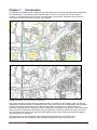
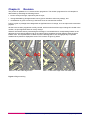
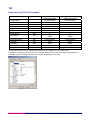
OS Landplan – plots and raster data
User guide
Contents
Section
Preface
Chapter 1
Chapter 2
Chapter 3
Chapter 4
Chapter 5
Chapter 6
Annexe A
Page no
..................................................................................................................................................3
Contact details ..........................................................................................................................3
Use of the product.....................................................................................................................3
Purpose and disclaimer ............................................................................................................3
Copyright in this guide ..............................................................................................................3
Data copyright and other intellectual property rights ................................................................4
Trademarks ...............................................................................................................................4
Back-up provision of the product ..............................................................................................4
Using this guide/specification....................................................................................................4
Introduction .............................................................................................................................5
Content.....................................................................................................................................7
Scottish and Welsh place/area names .....................................................................................7
Scale.........................................................................................................................................8
Coverage...................................................................................................................................8
Formats ....................................................................................................................................9
TIFF...........................................................................................................................................9
Data compression.................................................................................................................10
Image compression.................................................................................................................10
Lossless compression .......................................................................................................10
Lossy compression ............................................................................................................10
TIFF.........................................................................................................................................10
Revision .................................................................................................................................11
Product and service performance report form ..................................................................12
v1.0 – 06/2007
OS Landplan – plots and raster data user guide contents v1.0 – 06/2007 © Crown copyright Page 2 of 23
Preface
This user guide (hereafter referred to as the guide) is designed to provide an overview of OS Landplan®
(hereafter referred to as the product), and it gives guidelines and advice on how a customer might derive the
maximum benefit from the product. It assumes a general knowledge of geographic information. If you find an
error or omission in this guide, or otherwise wish to make a comment or suggestion as to how we can
improve the guide, please contact us at the address shown below under contact details or complete the
product and service performance report form at annexe A and return it to us.
Contact details
Our Customer Service Centre will be pleased to deal with your enquiries:
Customer Service Centre
Ordnance Survey
Romsey Road
SOUTHAMPTON
SO16 4GU
General enquiries (calls charged at local rate): +44 (0)8456 05 05 05
Dedicated Welsh Language HelpLine: 08456 05 05 04
Textphone (deaf and hard of hearing users only please): +44 (0)23 8079 2906
Email: [email protected]
Or visit the Ordnance Survey website at www.ordnancesurvey.co.uk
Use of the product
The terms and conditions upon which the product, including this guide, is made available to you and your
organisation are contained in the customer contract made between you and Ordnance Survey. If there is an
inconsistency between the terms of your customer contract and this guide, then the terms of your customer
contract prevail. If you or your organisation has not signed a valid current customer contract then you are not
entitled to use the product.
Purpose and disclaimer
This guide/specification is provided for guidance only and does not constitute any warranty, representation,
undertaking, commitment or obligation (express or implied) about the product or its suitability for any
particular or intended purpose. Any warranties, representations, undertakings, commitments and obligations
given by Ordnance Survey about the product and/or its suitability for any particular or intended purpose are
set out in your customer contract. It is your responsibility to ensure that this product is suitable for your
intended purpose.
Ordnance Survey does not accept any liability (whether for breach of contract, negligence or otherwise) for
any loss or liability you or any third party may suffer in relying on this guide and any guidance, suggestion,
advice or explanation provided in it. Any liability that Ordnance Survey has to you in relation to the product,
its supply, use, accuracy, data supplied, functionality or any other liability arising out of or in connection with
the product is limited as set out in your customer contract.
We may change the information in this guide at any time without notice.
We do not accept responsibility for the content of any third-party websites referenced or accessed in or
through this guide, any contractual documentation, and/or the Ordnance Survey website.
Copyright in this guide
This guide (including for the avoidance of doubt any mapping images reproduced herein), is
© Crown copyright 2007. All rights reserved.
Any part of this guide may be copied for use internally in your organisation or business so that you can use
the product for the purpose for which it is licensed to your organisation or business (but not otherwise).
OS Landplan – plots and raster data user guide preface v1.0 – 06/2007 © Crown copyright Page 3 of 23
No part of this guide may be reproduced or transmitted in any form or by any means (including electronically)
for commercial exploitation without the prior written consent of Ordnance Survey.
No part of this guide may be copied or incorporated in products, services or publications that you generate
for onward sale, or as free promotional or support materials, without the prior written consent of
Ordnance Survey.
Data copyright and other intellectual property rights
The Crown (or, where applicable, Ordnance Survey’s suppliers) owns the intellectual property rights in
Ordnance Survey digital map data.
Full details of the terms and conditions under which Ordnance Survey digital map data may be processed
and/or manipulated or copied by a customer – whether or not for use on PCs or workstations or for making
hard copies – are available from the Customer Service Centre, please see contact details. You should check
the terms and conditions with us before using the data. It is also the responsibility of the holder of the digital
map data to ensure that any plotted or printed output contains the required copyright and database
acknowledgements in a conspicuous position.
Trademarks
Ordnance Survey, the OS Symbol, Landplan and OS are registered trademarks of Ordnance Survey, the
national mapping agency of Great Britain.
Acrobat Reader and Adobe are registered trademarks of Adobe Systems Incorporated.
Intel is a registered trademark of Intel Corporation.
Motorola is a registered trademark of Motorola, Inc.
Oracle is a registered trademark of Oracle International Corporation.
Unisys is a registered trademark of Unisys Corporation.
UNIX is a registered trademark of X/Open Company Ltd.
Back-up provision of the product
You are advised if the product is supplied as data to copy to a back-up medium.
Using this guide/specification
The documentation is supplied in portable document format (PDF) only. Free Adobe® Acrobat Reader®
software, which displays the guide, incorporates search and zoom facilities and allows you to navigate
within. Hyperlinks are used to navigate between associated parts of the guide and to relevant Internet
resources by clicking on the blue hyperlinks and the table of contents.
If you are unfamiliar with any words or terms used and require clarification please refer to the glossary at the
end of the document.
OS Landplan – plots and raster data user guide preface v1.0 – 06/2007 © Crown copyright Page 4 of 23
Chapter 1
Introduction
OS Landplan is available as both contextual map raster data and as plot output generated from large-scale
source information. It is available as site-centred output, in colour or monochrome, with and without
contours, in TIFF RGB format using LZW (Lempel-Zif-Welch) compression. Examples of the colour and
monochrome versions are shown in figures 1 and 2 below.
Figure 1: Example of colour OS Landplan
Figure 2: Example of monochrome OS Landplan
The product provides an image where the detail has been converted to a grid of pixels, which can then be
displayed on computer screens or available as a plot. The product covers all of Great Britain and is supplied
as site-centred plots or data aligned to the National Grid. Data is converted into a raster format at a
resolution of 300 dots per inch (dpi) and a pixel is equivalent to .85 metres on the ground. This resolution has
been chosen as it maintains the necessary clarity for text shown on the map and for plot output. The colour
version assigns three colours, red, green and blue (RGB) to each pixel, the monochrome version assigns
one shade of grey to each pixel.
The data product can be overlaid with other Ordnance Survey products or a customer’s own
geographic/business data, besides providing a detailed geographic context in its own right.
OS Landplan – plots and raster data user guide chapter 1 v1.0 – 06/2007 © Crown copyright Page 5 of 23
OS Landplan is produced to provide customers with a detailed product that is made available in TIFF LZW
format to provide either a map of an area when used on its own or as a means of providing geographic
context to help a customer visualise their own data.
As can be seen from figure 1, the pattern of development within the landscape can clearly be seen, and this
makes OS Landplan particularly useful for site development locations.
OS Landplan – plots and raster data user guide chapter 1 v1.0 – 06/2007 © Crown copyright Page 6 of 23
Chapter 2
Content
OS Landplan shows the following features:
• buildings, structures and leisure areas;
• roads, paths and tracks;
• vegetation and surface features;
• water features and associated detail;
• railways and associated detail;
• height and control information;
• archaeological and antiquity information;
• administrative boundary information;
• text;
• miscellaneous information – remote areas, telephone lines, footbridges, house names and all buildings;
and
• contours are optional.
The following administrative boundaries are shown:
Local government
Parliamentary
County (England)
European electoral region
District (England)
Parliamentary electoral region (Scotland)
Greater London Assembly constituency
Parliamentary constituency (England)
Unitary authorities
Parliamentary constituency (Westminster)
Civil parish (England)
Parliamentary constituency (Scotland)
Community (Wales)
Assembly constituency (Wales)
Assembly electoral region (Wales)
Scottish and Welsh place/area names
Where a name has an alternative form in a different language and it is not possible to establish which of the
two names is more useful and acceptable, both names will be shown. Where there is insufficient space to
show both names, only one will be shown:
• In Scotland – the anglicised version; and
• In Wales – the Welsh version.
OS Landplan – plots and raster data user guide chapter 2 v1.0 – 06/2007 © Crown copyright Page 7 of 23
Chapter 3
Scale
OS Landplan is derived from large-scale information surveyed at:
• 1:1250 scale – covering major towns and cities;
• 1:2500 scale – smaller towns, villages and developed rural areas; and
• 1:10 000 scale – mountain, moorland and river estuary areas.
Cartographic generalisation is used to emphasise, simplify, select and sometimes omit features to produce a
cartographic representation of the landscape at a scale of 1:10 000.
The recommended printed copy or plot output is at 1:5000 to 1:10 000 scale, but viewing data on a computer
screen is normally between 1:5000 and 1:8000 scale.
Coverage
OS Landplan is available in a variety of plots and data sizes; see technical specification for details.
Data or plots can be site-centred using a postcode, a place name or a National Grid reference
OS Landplan – plots and raster data user guide chapter 3 v1.0 – 06/2007 © Crown copyright Page 8 of 23
Chapter 4
Formats
OS Landplan data is available as:
• Tagged Image File Format (TIFF) with 256 RGB colours with LZW compression.
TIFF
TIFF is a file-based format for storing and interchanging raster images, with the most recent version – 6.0 –
published in 1992.
There are two types of architecture for a TIFF. Many mainframe computers use what is known as an
OS big-endian (Motorola®) architecture. Most modern computers, including personal computers (PCs), use
the little-endian (Intel®) system. OS Landplan TIFFs are supplied with Intel architecture. Converting between
these two systems is possible but, as a general rule, modern software should be expected to handle both of
these outputs without operator intervention.
OS Landplan conforms to the TIFF 6.0 standard. Customers are recommended to contact their system
suppliers to ensure that it can read the Intel/little-endian TIFF architecture.
OS Landplan – plots and raster data user guide chapter 4 v1.0 – 06/2007 © Crown copyright Page 9 of 23
Chapter 5
Data compression
The data volumes for each file format are influenced by the level of data compression.
Image compression
When an image is compressed, duplicated data that has no value is removed or saved in a shorter form,
which reduces a file’s size. For example, if large areas of water are the same tone, only the value for one
pixel needs to be saved, together with the locations of the other pixels with the same colour. When the image
is edited or displayed, the compression process is reversed. When raster is compressed, not only are the
data volumes reduced but the user can download, display, edit and transfer images more quickly.
There are two forms of compression: lossless and lossy:
Lossless compression
As its name suggests, lossless compression does not lose information within an image. A lossless
compression retains the original quality of an image when it is uncompressed, for example, OS Landplan
data has LZW compression. This process doesn’t provide much compression, so file sizes remain large.
Lossless compression is used mainly where detail is important, such as when planning to make large prints.
Lossy compression
This process degrades images to some degree, meaning that the decompressed image isn't quite the same
quality as the original. The more an image is compressed, the more degraded it becomes. In many
situations, such as posting images on the Internet or printing small- to medium-sized prints, the image
degradation isn’t so obvious. If a lossy compressed image, like the one shown in figure (3) below, is over
enlarged the degradation will become apparent, and therefore OS Landplan is not supplied using a lossy
compression.
Enlarged lossy compressed image
Figure 3
TIFF
TIFF is one of the most commonly used lossless image formats. TIFF is primarily designed for raster data
interchange, and is supported by numerous image-processing applications. This permits much more efficient
access to very large files that have been compressed.
TIFF LZW, a popular lossless data compression technique that uses a simple compression algorithm.
OS Landplan – plots and raster data user guide chapter 5 v1.0 – 06/2007 © Crown copyright Page 10 of 23
Chapter 6
Revision
The product is updated via a 1:10 000 revision programme. The revision programme for OS Landplan is
determined by assessing the following factors:
• known surveyed change, captured by the surveyor;
• change indicated by photogrammetric survey (which includes rural survey sweep); and
• consideration is given to how long it has been since an area was last revised.
Priority is given to prestige sites categorised as significant items of change, such as major road construction
projects.
All tiles in the revision programme are fully revised, which means that all surveyed change is included in the
revision, not just significant items of survey change.
Where a line feature ends by intersecting the tile edge, it is matched with its corresponding feature on the
adjacent tile, so that both features end on the same unique coordinate and both features have the same
feature code. The representation of detail across the tile edge will be of a cartographically acceptable
standard when plotted or displayed at scale. This is shown in figure (4) below.
Before 1:10 000 scale edge match
After 1:10 000 scale edge match has taken place
Figure 4: Edge matching
OS Landplan – plots and raster data user guide chapter 6 v1.0 – 06/2007 © Crown copyright Page 11 of 23
Annexe A
Product and service performance report form
Ordnance Survey welcomes feedback from its customers about OS Landplan.
If you would like to share your thoughts with us, please print a copy of this form and when completed post or
fax it to the address below.
Your name: ..........................................................................................................................................................
Organisation: .......................................................................................................................................................
Address: ...............................................................................................................................................................
..............................................................................................................................................................................
..............................................................................................................................................................................
Postcode: .............................................................................................................................................................
Phone: .................................................................................................................................................................
Fax: ......................................................................................................................................................................
Email: ...................................................................................................................................................................
Quotation or order reference: ..............................................................................................................................
Please record your comments or feedback in the space below. We will acknowledge receipt of your form
within 3 working days and provide you with a full reply or a status report within 21 working days.
If you are posting this form, please send it to:
OS Landplan Product Manager, Ordnance Survey, Romsey Road, SOUTHAMPTON, SO16 4GU.
If you wish to return it by fax, please dial 023 8079 2615.
Any personal information that you supply with this report form will be used by Ordnance Survey only in the
improvement of its products and services. It will not be made available to third parties.
OS Landplan – plots and raster data user guide annexe A v1.0 – 06/2007 © Crown copyright Page 12 of 23
OS Landplan – plots and raster data
Technical specification
Contents
Section
Page no
Introduction
Chapter 1
Chapter 2
Chapter 3
Annexe A
................................................................................................................................................14
Purpose of this specification and disclaimer...........................................................................14
Copyright in this specification .................................................................................................14
Specification..........................................................................................................................15
Legend ...................................................................................................................................16
Image file directory (TIFF LZW) ...........................................................................................17
TIFF.........................................................................................................................................18
Image directory (TIFF) OS Landplan .................................................................................18
Glossary.................................................................................................................................19
v1.0 – 06/2007
OS Landplan – plots and raster data technical specification contents v1.0 – 06/2007 © Crown copyright Page 13 of 23
Introduction
Purpose of this specification and disclaimer
This is the technical specification (hereafter referred to as the specification) applicable to OS Landplan
(hereafter referred to as the product), which is referred to in the Framework Direct Licence, Specific Use
Framework Partner Licence or your other customer contract for the product.
We may change the information in this specification at any time, giving you the notice period specified in the
customer contract made between you and Ordnance Survey.
We do not accept responsibility for the content of any third party websites referenced or accessed in or
through this specification, any other contractual documentation, and/or the Ordnance Survey website.
Copyright in this specification
This specification (including for the avoidance of doubt any mapping images reproduced herein) is
© Crown copyright 2007. All rights reserved.
Any part of this specification may be copied for use internally in your organisation or business so that you
can use OS Landplan for the purpose for which it is licensed to your organisation or business (but not
otherwise).
No part of this specification may be reproduced or transmitted in any form or by any means (including
electronically) for commercial exploitation without the prior written consent of Ordnance Survey.
No part of this specification may be copied or incorporated in products, services or publications that you
generate for onward sale, or as free promotional or support materials, without the prior written consent of
Ordnance Survey.
OS Landplan – plots and raster data technical specification introduction v1.0 – 06/2007 © Crown copyright Page 14 of 23
Chapter 1
Specification
The following chapters include information about OS Landplan colour/monochrome, site-centred plots and
raster data; file compression; symbology; and format.
Specification OS Landplan
Data source
1:10 000 scale production database
Availability
National coverage
Resolution
300 dots per inch
Data structure
Raster
Data transfer format
TIFF 8-bit 256 RGB colours compressed (LZW*)
Data specification
All map features, with the option of contours
Update frequency
Continuous update (see chapter 6 in the user guide)
PDF Plot options
Standard sheet
1:10 000
5 km by 5 km = 25 km²
Colour or monochrome,
with or without contours
A4 1:5 000
1:5 000
800 m by 800 m = 0.64 km²
A4 1:10 000
1:10 000
1 600 m by 1 600 m = 2.56 km²
Site-centred 5 km by 5 km, 1:10 000
1:10 000
5 km by 5 km = 25 km²
Site-centred 3 km by 3 km, 1:5 000
1:5 000
3 km by 3 km = 9 km²
OS Landplan customised plot
1:5 000 to
minimum paper size: 160 mm by 160 mm
Approximate storage volumes
Compressed: 0.5 to 24 Mb
1:10 000 at
intervals of
500 metres
maximum paper size: 2 500 mm by 730 mm
TIFF Data options
OS Landplan Data source scale minimum order: 1 km
Colour or monochrome,
with or without contours
maximum order: 25 km TIFF
Approximate storage volumes – compressed: 0.5 to 2 Mb
* If LZW compressed formats are used then registration may be required. Guidance on the Unisys® licence is
available on the Unisys website at http://www.unisys.com/about__unisys/lzw
OS Landplan – plots and raster data technical specification chapter 1 v1.0 – 06/2007 © Crown copyright Page 15 of 23
Chapter 2
Legend
OS Landplan – plots and raster data technical specification chapter 2 v1.0 – 06/2007 © Crown copyright Page 16 of 23
Chapter 3
Image file directory (TIFF LZW)
The Image file directory for TIFF will contain a selection of the following entries:
• Tag 255 (SubfileType)
An indication of the kind of data contained in this sub-file, for example, value = 1
• Tag 256 (ImageWidth)
The number of columns in the image, the number of pixels per row, for example, value = 2318
• Tag 257 (ImageLength)
The number of rows of pixels in the image, for example, value = 2312
• Tag 258 (BitsPerSample)
Number of bits per component, for example, value = 8
• Tag 259 (Compression)
Compression scheme used on the image data, for example, value = 5 (LZW)
• Tag 262 (Photo.Interpretation)
The colour space of the image data, for example, value = 2 (RGB Palette).
• Tag 273 (StripOffsets)
For each strip, the byte offset of that strip, for example, value = 320
• Tag 274 (Orientation)
Value = 1
• Tag 277 (SamplePerPixel)
Value = 3
• Tag 278 (RowsPerStrip)
The number of rows in each strip, for example, value = 2312
• Tag 279 (StripByteCounts)
For each strip, the number of bytes in that strip after compression, for example, value = 247278
• Tag 280 (MinSampleValue)
Value = 0
• Tag 281 (MaxSampleValue)
Value = 255
• Tag 282 (XResolution)
The number of pixels per resolution unit in the image width, for example, value = 300/1
• Tag 283 (YResolution)
The number of pixels per resolution unit in the image length, for example, value = 300/1
• Tag 284 (PlanarConfiguration)
Value = 1
• Tag 296 (ResolutionUnit)
Units used for resolution, for example, value = 2 (Inch)
• Tag 305 (Software)
value = gXconvert-TIFF V 2.17
Note: The values given above are relevant to OS Landplan Colour LZW raster data available through
Ordnance Survey Mapping and Data Centres.
OS Landplan – plots and raster data technical specification chapter 3 v1.0 – 06/2007 © Crown copyright Page 17 of 23
TIFF
Image directory (TIFF) OS Landplan
Tag number
File Byte Order :
Magic Number :
Number of fields in IFD :
NewSubfileType
ImageWidth
ImageLength
BitsPerSample
Compression
255
256
257
258
259
PhotoInterpretation
XResolution
YResolution
ResolutionUnit
Software
262
282
283
296
305
Colour TIFF 8-bit
LZW compressed
II (Little-endian)
42
19
1
2318
2312
8
5
(LZW)
2 (RGB Palette)
300/1
300/1
2 (Inch)
gXconvert-TIFF V 2.17
Monochrome TIFF 8-bit
LZW compressed
II (Little-endian)
42
19
1
2318
2312
8
5
(LZW)
2 (RGB Palette)
300/1
300/1
2 (Inch)
gXconvert-TIFF V 2.17
The tag values listed in the above table are relevant to OS Landplan Intel TIFF raster data.
It should be noted that customers can access tag information from a raster file image by right clicking on a
TIFF data image and looking at properties, and then left clicking on summary.
OS Landplan – plots and raster data technical specification chapter 3 v1.0 – 06/2007 © Crown copyright Page 18 of 23
Annexe A
Glossary
The purpose of this chapter is to provide a glossary of terms used in the definition of products, services,
licensing and other terms and conditions for OS Landplan.
American Standard Code for Information Interchange (ASCII)
A standard binary coding system used to represent characters within a computer.
binary digit (BIT)
The smallest possible unit of data, resulting from a choice between 0 and 1.
boundary
A boundary forms the division between two similar real-world objects, for example, property boundary or
administrative boundary, and is defined by one or more lines.
byte
A unit of computer storage of binary data, usually comprising 8 bits, equivalent to a character.
character
A distinctive mark; an inscribed letter; one of a set of writing symbols.
character code
The binary representation of a single element of a character set; for example, EBCDIC, ASCII.
coordinate pair
A coordinate pair is an easting and a northing (see rectangular coordinates).
coordinate transformation
A computational process of converting an image or map from one coordinate system to another.
compact disc
Read only memory (CD-ROM). A data storage medium. A 12-cm disc similar to the audio CD. It is an alloy
disc pitted with tiny holes and then coated in plastic. A laser head reads the pattern of the holes and
translates them into binary data.
copyright
The sole legal right to print or publish a work. Crown copyright subsists in all Ordnance Survey publications
for a 50-year period, from the end of the year in which they were first published, by virtue of the Copyright
Designs and Patents Act 1988.
customer
An organisation or individual that makes use of Ordnance Survey’s data supply facilities. This includes both
direct sales customers of Ordnance Survey as well as customers of Licensed Partners. It does not include
anyone, or any organisation, that has access to Ordnance Survey material without charge.
data
A representation of facts, concepts or instructions in a formalised manner suitable for communication,
interpretation or processing.
database
An organised, integrated collection of geographic data, which may or may not be spatial data. It is stored so
that specific applications can access the data by different logical paths. A database is accessed and
managed by a database management system (software for managing database information).
data format
A specification that defines the order in which data is stored or a description of the way data is held in a file
or record.
data quality
Attributes of a dataset that define its suitability for a particular purpose, such as completeness, positional
accuracy, currency and so on.
OS Landplan – plots and raster data technical specification annexe A v1.0 – 06/2007 © Crown copyright Page 19 of 23
data structure
The defined logical arrangement of data as used by a system for data management; a representation of a
data model in computer form.
data transfer medium
This is the means by which computer files are transferred from one computer to another. Transfer media
may be subdivided into communications media and physical media.
dataset
Data as supplied in a particular format to customers, whether internal or external to Ordnance Survey.
density
A measure of the number of units of data held on a stated length of storage surface. For example, some
magnetic tapes may be recorded at a density of 1 600 bits per inch (bpi). Often referred to as packing
density.
delivery mechanism
The method of supply of data to a customer (such as offline and online).
descriptive name
Names describing a real-world object or feature (for example, school) as shown on the OS Landplan map.
definitive name
The name as shown on the OS Landplan map.
digital
Data that is expressed as numbers (digits) in computer-readable form.
digital update
The supply of digital data to a customer following revision by the production team.
direct sale
A direct transaction between Ordnance Survey and a customer.
distinctive name
A text feature that form(s) a name that distinguishes it from other text features of the same type, for example,
Millbrook School.
dots per inch (dpi)
The resolution, or fineness, of a raster image.
eastings
See rectangular coordinates.
ECW
The Enhanced Compressed Wavelet (ECW) raster image compression software has been designed to
compress, display, serve on the Internet and distribute raster. The key characteristic of wavelet-based
compressions is that it is able to preserve a very good quality of the image with high compression ratios.
This compression format uses mathematical wavelet transformations to store image data rather than storing
a grid of values for image pixels such as TIFF or other common formats. This allows a great reduction in the
amount of disk space it takes to store large images, whilst retaining nearly all the original image's quality,
colour and detail.
ECW is a lossy format, meaning that some information is lost when the image is converted from its original
format to the ECW format. However, wavelet compression is very good at retaining the character of images,
so the amount of loss is very small.
JPEG
An image named after the Joint Photographic Experts Group, it uses a lossy compression format. It is
designed for compressing full colour or monochrome images of natural, real-world scenes and works well on
photographs. It is the de facto standard for photographs on the Web.
OS Landplan – plots and raster data technical specification annexe A v1.0 – 06/2007 © Crown copyright Page 20 of 23
encoding
The process of converting information to a computer-readable form, for example, digitising maps.
extended binary coded decimal interchange code (EBCDIC)
An 8-bit-character encoding scheme, for example, 10011100. These can also be letters or specific
characters, for example, + =.
feature
A geographic entity such as a building or stream, either taken from a map or surveyed directly from the real
world. Can be a point/symbol, text or line.
format
The specified arrangement of data, for example, the layout of a printed document, the arrangement of the
parts of a computer instruction, the arrangement of data in a record.
geographic coordinates
Coordinates, usually expressed as latitudes and longitudes, which define positions on the Earth's surface.
georef
A definition for registering raster images within a geographic framework is the process of assigning map
coordinates to the raster image data and resampling the pixels of the image to conform to the map projection
grid.
gigabyte (Gb)
1 073 741 824 bytes, a measure of data storage capacity (see megabyte).
kilobyte (Kb)
1 024 bytes, a measure of data storage capacity.
Licensed Partner
Any organisation that has entered into a formal licence agreement with Ordnance Survey to market map
information or to incorporate map data with their application or service.
linear feature
Map feature in the form of a line (for example, river, boundary) that may or may not represent a real-world
(existent) feature.
local origin
The local origin of rectangular coordinates is the south-west corner of the 1 km by 1 km National Grid square
they identify.
map scale
The ratio between the extent of a feature on the map and its extent on the ground, normally expressed as a
representative fraction, for example, 1:1250, 1:50 000 and so on.
megabyte (Mb)
1 048 576 bytes, a measure of data storage capacity (see gigabyte).
National Grid
The metric grid on the Transverse Mercator projection used by Ordnance Survey on all post-Second World
War mapping to provide an unambiguous spatial reference in Great Britain for any place or entity, whatever
the map scale.
MrSid
MrSid (Multi-resolution Seamless Image Database) is a wavelet-based image compressor, viewer and file
format for large raster images that enables instantaneous viewing and manipulation of images locally and
over networks while maintaining maximum image quality.
northings
See rectangular coordinates.
OS Landplan – plots and raster data technical specification annexe A v1.0 – 06/2007 © Crown copyright Page 21 of 23
Oracle®
The relational database management system used for the 1:50 000 Scale Gazetteer.
order
A request from a customer for the supply of map data. The scope of an order may be constrained by an
agreement for a period-licence service.
origin
The zero point in a system of rectangular coordinates.
pixel
In this product a pixel is a single point represented by a square.
points
A pair of coordinates.
raster data
Attribute data expressed as an array of pixels, with spatial position implicit in the ordering of the pixels.
RGB colour model
The RGB colour model is an additive model in which red, green and blue (often used in additive light models)
are combined in various ways to reproduce other colours. The name of the model and the abbreviation
‘RGB’ come from the three primary colours, red, green and blue. These three colours should not be
confused with the primary pigments of red, blue and yellow, known in the art world as ‘primary colours’.
real-world object
The real-world feature represented by a feature, for example, a building, a fence, a wood.
rectangular coordinates
Also known as x-y coordinates and as eastings and northings. These are two-dimensional coordinates that
measure the position of any point relative to an arbitrary origin on a plane surface (for example, a map
projection, a digitising table or a VDU screen).
stipple
Used to produce light or dark shading (for example, building /water fill); this is dependent on spacing of the
dots – the denser the dots, the darker the effect.
string
A set of items that can be arranged into a sequence according to a rule.
supply format
The file format in which the data is supplied to the customer.
tag
Tags are unique numbers that are used for identifying specific information in TIFF files, for example, image
width, image length, bits per sample, photo interpretation and resolution.
terminator
Character, or character string, or field, or record used to signal the end of a record, or section, or volume or
database.
tile
A unit of map used to divide large areas into regular and more manageable sizes.
TIFF
TIFF is a tagged image file format-based file format for storing and interchanging raster images with the most
recent version – 6.0 published in 1992.
transfer format
The format used to transfer data between computer systems. In general usage this can refer not only to the
organisation of data but also to the associated information, such as attribute codes, which are required in
order to successfully complete the transfer.
OS Landplan – plots and raster data technical specification annexe A v1.0 – 06/2007 © Crown copyright Page 22 of 23
transfer medium
The physical medium on which digital data is transferred from one computer system to another, for example,
compact disc.
UNIX®
An operating system that supports multitasking and is used by many workstations and mini computers.
update
The process of adding to and revising existing digital map data to take account of change.
volume
A physical unit of the transfer medium, that is a single disk or a single DVD.
OS Landplan – plots and raster data technical specification annexe A v1.0 – 06/2007 © Crown copyright Page 23 of 23