1
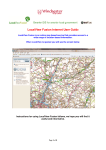
OntheMap Internet User Guide
OntheMap is an online service that provides access to a wide range of map
based information. The instructions below work for all of the different map
services available on Staffordshire Web.
We hope you find OnTheMap useful. You will notice that there is no option to
print the maps. If we were to provide this option, in some cases it would
infringe Copyright regulations. Should you have any suggestions that might
improve the site, or you require any further assistance please use our
Feedback form.
Getting Started
When you open OntheMap you will see a map similar to the one below.
Use these tools to zoom and pan on the map. You can also use the
scroll wheel on your mouse or hold the shift key down on the
keyboard and drag a box around the area you require, whilst holding
the left mouse button down, then let go. To pan or move around the
map, click and hold the left mouse key and drag it across the screen.
and the map will zoom to that area.
To change the map background from
Ordnance Survey maps to Aerial
photographs, click on these buttons.
Use the drop down arrow to search for an
address or postcode in the box provided.
Or, zoom in on the map and drag the
pointer to the location you are interested
in.
The Home button returns to this screen.
The Reset button returns to the full extent
of the map and clears any searches.
Use the Map Features button to turn
different sets of information on and off.
Use the Local Information button to find
out what is within a stated distance of the
address or location chosen. (This feature
may not be available)
Selecting locations by searching addresses
You can search for an address by typing the address, a postcode or street
name in the search box and pressing the search button. Select an address
from the list and the map will zoom to that location. It zooms in quite close so
you may need to zoom out to see more detail on the map.
Viewing Local Information (if available)
When the map has moved to the location you will see that on the left hand
side a list of information has appeared. Click the down arrow alongside any of
the listed items and if there are any of those features within a stated distance
of your location, they will appear in a list below the name. Click on one of
these and the map will zoom to the features outline as shown below.
Map Layers
This is the list of all the map information that is available
to view. They are called layers. You have the ability to
turn different layers on and off and have multiple layers
on at any one time. This is simply done by placing a tick
in the checkbox.
Clicking on any feature shown on the map will show
information about all the features at that point. This can
include links to other web pages or even photographs.