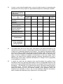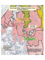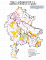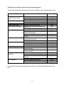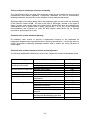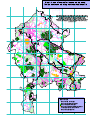
1
Planning for Landscape Change:
An Introduction and User’s Guide to
Supplementary Planning Guidance to
the Staffordshire and Stoke on Trent
Structure Plan, 1996 – 2011
Planning for Landscape Change:
Supplementary Planning Guidance
to the
Staffordshire and Stoke on Trent
Structure Plan, 1996 – 2011
Volume 1:
An Introduction and
User’s Guide
Staffordshire County Council,
Development Services Department, 2000
Adopted on 10 May 2001 as
Supplementary Planning Guidance
to the Staffordshire and Stoke-on-Trent
Structure Plan 1996-2011
Contents
Page
Introduction
1
Landscape and landscape change
3
A strategy based on landscape character
4
Assessing compliance with Structure Plan Policy NC2
6
Detailed landscape descriptions
10
Map 1: Landscape policy objectives
Opposite 6
Map 2: A Parish-based landscape map
Opposite 14
Introduction
Planning for Landscape Change is aimed primarily at planning officers in the Staffordshire
and Stoke-on-Trent Structure Plan area, and at developers and others who need to be
informed about policy and practice for the conservation, enhancement and regeneration of
the rural landscapes of the Plan area. It may also prove to be of value in a wider context, as
a means of informing other decisions relating to land use and land management.
The full Supplementary Planning comprises:
h
this Introduction and User’s Guide (Vol. 1);
h
an explanation of the method used to generate the maps and landscape descriptions
that follow (Vol. 2);
h
a map showing the distribution of a number of distinct types of landscape that are
found within the Structure Plan area (Appendix 1);
h
a series of detailed descriptions of the character of those landscapes (Vol. 3);
h
a map showing the areas to which landscape policy objectives, described below,
apply (Appendix 1);
h
an appendix (Vol. 2) indicating the areas that are preferred for targeting resources for
woodland initiatives, including new planting and management.
Planning for Landscape Change draws on government guidance on development plan
policies for the conservation and enhancement of landscape character and quality, and on
work undertaken by the former Countryside Commission and English Nature to map and
describe the landscape character of England. It has been published having regard to the
views of the Panel appointed to conduct an Examination in Public of the Staffordshire and
Stoke on Trent Structure Plan 1996 – 2011. The Panel’s report, published in December
1999 stated that:
“…it seems inevitable to us that a substantial amount of information needs to be
published by SCC [Staffordshire County Council] to explain the meaning of the defined
landscape policy areas. What this documentation is called seems secondary to its
importance in raising awareness of the approach. However, we see every advantage in
it being subject to a full consultation exercise and then being adopted as SPG
[Supplementary Planning Guidance].”
That consultation exercise was carried out during the autumn of 2000, and this adopted
Guidance incorporates changes made as a result of representations. However, some
comments on the details of the landscape descriptions in Volume 3 will only become
available after the Guidance has been in use for some time. To take account of this, the
County Council invites such comments from users, and will incorporate any further changes,
based on them, in a revised version of this Guidance to be published in due course. Any
such comments should be addressed to the Corporate Director (Development Services),
Staffordshire County Council, Riverway, Stafford ST16 3TJ, for the attention of Steve Potter,
Head of Environmental Planning.
1
The Guidance supplements Policy NC2 of the Staffordshire and Stoke on Trent Structure
Plan, 1996 – 2011, which states:
Landscape protection
and restoration
Development should be informed by and be sympathetic to landscape
character and quality and should contribute, as appropriate, to the
regeneration, restoration, enhancement, maintenance or active conservation of
the landscape likely to be affected. Proposals with landscape and visual
implications will be assessed having regard to the extent to which they would:
(a)
cause unacceptable visual harm;
(b)
introduce (or conversely remove) incongruous landscape elements;
(c)
cause the disturbance or loss of (or conversely help to maintain):
(i)
landscape elements that contribute to local distinctiveness;
(ii)
historic elements which contribute significantly to landscape character
and quality, such as field, settlement or road patterns;
(iii)
semi-natural vegetation which is characteristic of that landscape type;
(iv)
the visual condition of landscape elements;
(v)
tranquillity.
2
Landscapes and landscape change
1.1
The modern countryside has come about through a long process of interaction
between people and the basic elements of the land: the rocks and soils, the hills,
slopes and valleys, the streams and rivers that drain them, and the plants and
animals that are native to the area, or that have been introduced to it. Physical
influences such as geology and landform are often the key determinants of
landscape character, but in places the overlying pattern of settlement, land use, or
field enclosure may be more significant. Human influences are evident not only in the
presence of physical features such as hedgerows and buildings, but also in the way
in which the land has been owned and managed. The resulting landscapes are
neither wholly natural, nor are they entirely man-made artefacts.
1.2
Changes in soils or a boundary between rock types still influence cropping patterns
and the distribution of wild plants, despite centuries of farming; variations in social
structures which came about before the Middle Ages, and more recently, have left
their legacy in the distribution and arrangement of villages and settlements. The
dialogue between people and the land has been long and constantly changing, but
always within the limits set by these elements. This effect has given rise to a
particular distinctiveness - a sense of identity - in each part of the county. Kinver and
its environs are very different from Leek and the Moorlands for very good reasons,
which inform and define the experience of place.
1.3
Because our landscapes result in part from human activities they have been in a
constant state of change, and will continue so. Attempts to preserve them
unchanged into the future are generally misguided and bound to fail. The increasing
pace and scale of change, however, has become a major cause for concern and
there are many who feel that much of what is valued is in danger of being lost, while
much of what is new is bland, insensitive and lacking in character. There is a danger
that modern technological processes will unwittingly erode local distinctiveness and
the quality associated with the experience of place, because they need not be
constrained by the limitations previously imposed by the rocks and soils and patterns
of settlement: a danger that the special qualities resulting from the historic dialogue
will be drowned out by the visual equivalent of noise.
1.4
With growing evidence that present day processes of change often degrade rather
than strengthen the character of the countryside, there is an urgent need to find
effective mechanisms for reversing this trend. This does not mean that we need to go
backwards to some rural idyll, even if this were possible, but if we are serious about
conserving the character of the countryside we need to find ways to retain pattern
and diversity in landscape. The challenge that we are faced with is to find new ways
of accommodating change, whilst maintaining that link with the past which helps to
give us a sense of belonging. Maintaining this link will require a commitment not only
to manage the countryside, but also to guide and control the forces for change.
3
A strategy based on landscape character
2.1
In the mid-1990s the former Countryside Commission recognised the need to build
on a developing trend of looking wider in its strategic thinking than the areas of
landscape with special qualities, such as National Parks and Areas of Outstanding
Natural Beauty, which it had originally been charged with protecting. It needed to
develop policies for the whole countryside, and as a basis for that process it needed
a consistent analysis of the character of the landscapes of England. As no such
analysis existed it commissioned, in partnership with English Nature and with help
from English Heritage, a project that came to be called the Character of England
project. The first output was a map which divides England into 181 discrete
Regional Character Areas (RCAs) based on the interaction at a regional scale
between the physiographic elements of landscapes and the patterns of land use and
settlement characteristic of them. Written summaries of the character of each of
these areas were also published. Some of the Character Areas are already familiar
because of their distinctiveness, e.g. Dartmoor, the Cotswolds, the Dark Peak and
the White Peak, but others including some in Staffordshire are less familiar because
their character is subtle and less easily defined. Nine Character Areas fall wholly or
partly within the Staffordshire and Stoke on Trent Structure Plan Area.
2.2
A process of decision making that builds on this work, and is based on an
understanding of landscape character and of the natural, historic and aesthetic
factors that in combination create local distinctiveness, has come to be known as the
character approach. It stands in contrast to the more traditional approach, which
sought to identify those landscapes of the greatest scenic value or natural beauty,
and to apply more restrictive planning policies within them, as a means of protecting
their special qualities. At the national level this has led to the statutory designation of
National Parks and Areas of Outstanding Natural Beauty, and locally to non-statutory
designation, in development plans, of landscapes termed variously as Special
Landscape Areas, Areas of Great Landscape Value, etc. The Staffordshire Structure
Plan, 1986 – 2001 and the Local Plans building on it contained policies for the
protection of Special Landscape Areas.
2.3
Planning Policy Guidance note 7, The Countryside - Environmental Quality and
Economic and Social Development (published by the Department of the Environment
in 1997), requires a fundamental reassessment of local countryside designations.
The guidance indicates that designations should only be maintained or extended
where there is good reason to believe that normal planning policies cannot provide
the necessary protection. It also commends the character approach, which ‘identifies
the unique character of different areas of the countryside without making judgements
about their relative worth’ as a means of accommodating change without sacrificing
landscape character.
But how is an understanding of local character and
distinctiveness to be acquired and propagated? Will every planning officer and
developer have to be trained in techniques of landscape assessment, to enable them
to analyse local character on a case-by-case basis? The Countryside Agency’s
Countryside Character volume for the West Midlands, published in July 1999, is
helpful in this respect, but it describes character at a regional level, using mapping
units that average about 280 square miles in area. It is very difficult to use this
broad-brush information as a means of informing planning decisions.
2.4
To overcome this difficulty the analysis of landscape character in the Structure Plan
area has been taken to a more detailed level, through a comprehensive assessment
of landscape character. The boundaries of the Character Areas which were broadly
delineated on the Character of England map have been more precisely defined, and
4
the descriptions of landscape character have been taken to a finer grain, with the
mapping and description of 22 landscape character types (LCTs). These
descriptions make up the greater part of the Supplementary Planning Guidance to
the Structure Plan.
2.5
No judgements about the relative worth of such landscape types have been
made, but the approach does acknowledge that any given landscape type will
be represented by some areas in which the underlying landscape character is
strongly expressed and the constituent elements are in good condition, and
other areas where this is not the case. Landscape quality can be defined in
these terms: it is quite distinct from scenic beauty, but it is strongly linked to
character. It is essentially an indicator of how clearly that character is
expressed, and of how the state of repair of landscape elements contributes
to an overall impression of an intact and unified landscape. Landscape
quality can be assessed with respect to the following factors:
i)
the presence or absence of landscape elements which have had some
permanence over time, and which are characteristic features of that
landscape type;
ii)
the presence or absence of relatively novel features which are incongruous in
that landscape type;
iii)
the condition of landscape features, and the likelihood of their continuing
survival as functional landscape elements;
iv)
the extent to which the landscape exhibits a clear and consistent pattern of
components resulting from a particular course of historical development;
v)
the continuity or ‘time depth’ of the landscape, which is a function of the
length of time since the last major change of land use that contributed
significantly to current landscape character;
vi)
the extent of survival of semi-natural habitat that is characteristic of the
landscape type.
2.6
The assessment of landscape quality, as defined above, has led to the mapping of
landscape policy objective zones (Map 1). Those areas of the highest quality fall
within the zones in which ‘active landscape conservation’ is the objective, and those
of the lowest quality in the ‘innovative landscape regeneration’ zones. See the box
on page 8 for more details.
2.7
These factors also contribute to landscape sensitivity, along with the landscape’s
general visibility and its tranquillity, which is a function of its isolation from factors
contributing to visual or noise intrusion. The landscapes which are most sensitive to
the impacts of development or land use change may justify more restrictive Local
Plan development control policies than those of lower sensitivity.
5
Assessing compliance with Structure Plan Policy NC2
3.1
The Staffordshire and Stoke on Trent Structure Plan, 1996 – 2011, has adopted the
‘character approach’ to landscape protection and restoration, and consequently it
makes no reference to local designations such as Special Landscape Areas.
Instead, it requires that development should satisfy a number of tests, laid out in
Policy NC2, to demonstrate that it is acceptable in terms of its landscape and visual
impact. The policy must, of course, be interpreted in the context of all others,
including those for the protection of Green Belt, and of ‘best and most versatile’
agricultural land.
3.2
The tests laid out in Policy NC2 are as follows:
1)
Are the development proposals adequately informed by an understanding of
the landscape character of the area within which the development would be
sited? Has the applicant made reference to Planning for Landscape Change,
or to the relevant section of the Countryside Agency publication Countryside
Character, Volume 5: West Midlands, or has an adequate independent
landscape character assessment been carried out?
2)
Is there evidence that the proposal has taken account of local landscape
character, e.g. in the choice of building materials and in the design, siting and
scale of the development?
3)
Will the proposed development contribute to the appropriate landscape policy
objective for the area? This can be determined by reference to Map 1. In any
landscape there will be a need to conserve some features, to restore some,
and possibly to replace others, in order to maintain or improve landscape
quality, but one of these themes will predominate. Thus, conservation is most
important in areas where the landscape features are in good condition and its
character is strongly expressed, and regeneration is the predominant theme
where character has been severely eroded and landscape features are in
poor condition. See the box, below, for more details.
4)
To what extent would the proposed development be visually intrusive? The
general visibility of each landscape, as determined by its landform and its tree
and woodland cover, has been mapped (see Appendix 1 of the Supporting
Documentation), and this contributes in part to the assessment of landscape
sensitivity. However, this question has to be addressed site-specifically.
5)
To what extent will the proposed development lead to the introduction of
features that are incongruous to the landscape in question, or are there
proposals for the removal of such features? Examples of incongruous
features are given in the detailed descriptions of landscape types. In this
respect development could have a positive impact, e.g. by removing industrial
dereliction, or a negative impact, e.g. by introducing overhead power lines to
a rural farming landscape previously devoid of them.
6
6)
Will the proposed development have an adverse impact on the evidence of
human interaction with the landscape over time, and to what extent? Such
evidence includes the pattern of settlement, from dispersed farmsteads to
nucleated villages; the pattern of field enclosure; agricultural artefacts, such
as ridge and furrow; the distribution of woodland and trees, and the road and
track pattern. Development can only rarely have a positive impact over the
short term in this respect, but good design can minimise its negative impact.
7)
Will the proposed development lead to the loss of semi-natural vegetation that
is characteristic of this type of landscape, or will it provide opportunities for its
conservation, restoration or reintroduction? The emphasis should be on such
vegetation being characteristic: there is little or no value, e.g. in attempting to
create heathland in a landscape that has not contained it historically. To do
so could undermine landscape character, rather than reinforcing it.
8)
To what extent will the proposed development affect other characteristic
landscape features, and will the impact be positive, e.g. by conserving
features that are otherwise at risk, or negative, by removing them? The
features characteristic of each landscape type are listed in their detailed
descriptions.
9)
Will the proposed development have any impact on the visual condition of all
of the elements that combine to give the landscape its distinctive character,
and will that impact be positive or negative? As an example, development
adjacent to previously unmanaged woodland, and dependent on it for
screening, could lead to the implementation of a management plan for it, and
this could improve both its visual condition (e.g. by the replanting of
windblown areas) and its likelihood of long-term survival.
10)
Will the proposed development have any impact on the tranquillity of the
area? Tranquil areas are those that are sufficiently remote from the visual or
noise intrusion of development or traffic to be considered unspoilt by urban
influences. They are mapped in Appendix 1. Within tranquil or semi-tranquil
areas there is a risk that built development or increased road traffic
associated with it will have a negative impact on their tranquillity.
7
Meeting landscape policy objectives
In areas for which the objective is landscape maintenance substantial emphasis should be
placed on ensuring that the development blends unobtrusively into the landscape and does
not lead to the loss of features characteristic of it. Where the objective is active landscape
conservation the same requirements apply, but in addition any development should make a
positive contribution, e.g. through the restoration or management of characteristic features
such as buildings, parkland or woodland.
Areas of somewhat lower landscape quality have as their objective landscape enhancement.
These areas have suffered some erosion of strength of character and loss of condition of
landscape elements. There is a particular need to encourage relatively small-scale
landscape conservation schemes such as hedgerow maintenance, habitat creation and tree
and woodland planting, to stem the decline in landscape quality that will otherwise become
more evident.
Where landscape restoration has been identified as the appropriate objective many of the
features previously characteristic of the landscape type will have been lost. The emphasis is
therefore on the re-creation of character through the provision of new features that are not
necessarily a slavish copy of those that have been lost, but which draw inspiration from
them. As an example, many of the areas falling within this category are within the former
coalfields, which had a characteristic pattern of small fields. That pattern is now almost
completely lost in many places and it would not be practicable to try to recreate it, for
economic reasons. However, the planting of small woodlands through e.g. the Forest of
Mercia project will help to re-create the sense of enclosure and the reduction in scale of the
landscape previously provided by the field pattern.
In some areas the loss of the characteristic features and patterns of the landscape is so
complete that restoration is not possible, and replacement landscapes of a new character
are required. This is particularly the case where the reclamation of formerly derelict land has
resulted in engineered landforms, or where past development has resulted in major new
landscape features. An example is the winning of sand and gravel in the Tame and Trent
Valleys, between Tamworth and Burton upon Trent. This is resulting in an extensive chain
of new lakes which are not characteristic of the former valley floodplain, but which have the
potential to create a new landscape of great character.
8
3.3
A matrix, such as that illustrated below, may be a helpful means of summarising the
assessment of the likely impact of a proposed development on landscape character.
Landscape policy
objective appropriate
to the area:
Impact with respect
to:
Incongruous landscape
elements
Historic landscape
elements
Characteristic seminatural vegetation:
Other landscape
elements adding to
distinctiveness:
Visual condition of
landscape elements:
Tranquillity:
Nature and strength of the impact
Strongly
Negative Neutral
Positive
Strongly
negative
positive
Visual impact:
Overall contribution
to the landscape
policy objective:
3.4
The detailed tests laid out in Policy NC2, and based on the factors listed above, are
intended to provide a means of assessing the impact of development or other change
of land use on landscape character and condition. The mapping of landscape quality
provides a means of identifying the appropriate landscape policy objective for each
area, and the assessment of landscape sensitivity should assist in indicating how
easy it will be to mitigate the impacts of development or land use change. Taken
together, the maps and the detailed landscape character descriptions will help in
determining to what extent a particular development or change of use is appropriate
to the landscape in question.
3.5
It should be noted that the mapping units used throughout the guidance have
boundaries which have generally been drawn to follow a recognisable feature on the
ground, but in appreciating landscape character our perception does not stop at such
boundaries. The character of any particular area will be influenced visually by that of
surrounding areas. Decisions relating to the location and nature of development
should be informed by all of the relevant material in this guidance, and it will
sometimes be necessary to refer to two or more landscape character descriptions,
and to consider the landscape policy objectives for surrounding land.
9
Detailed landscape descriptions
4.1
The full Supplementary Planning Guidance contains detailed descriptions of all of the
22 landscape character types and six sub-types that occur in the nine Regional
Character Areas found within the Structure Plan area. This requires about 250
pages of text. For many purposes it will be sufficient to select the information relating
to the area in question, and such customised versions of the Guidance can be
prepared on request. As an example of this facility the relevant information for a
single parish - Brown Edge, in the Staffordshire Moorlands - follows.
4.2
Brown Edge falls within the Potteries and Churnet Valley Regional Character area,
and this is described first, to provide a regional landscape context. This is followed
by descriptions of the two landscape character types found within the parish, i.e.
ancient slope and valley farmlands and gritstone uplands. The map shows the
general distribution of these landscape types, and the landscape policy objectives
that are considered relevant.
10
Potteries and Churnet Valley
1.
This Regional Character Area, which is contained almost wholly within the
county boundary, marks a zone of transition between lowlands and uplands,
in the elevation range from about 100m to 300m O.D. The central part
comprises heavily dissected hills and the extensively wooded valley of the
River Churnet, associated with Carboniferous and Permo-Triassic
sandstones, overlain in the main by brown earths and podzols. To the north
west, towards Biddulph Moor and Mow Cop, outlying gritstone outcrops with
stagnogleys and peat soils give rise to deeply incised plateaux of moorland
and upland grassland. Carboniferous coal measures, covered in glacial drift
and with stagnogley soils, underlie the fringes of Stoke-on-Trent.
2.
Traces of early colonisation of the area survive chiefly in the form of barrows
on high ground. The remains of an Iron Age hillfort survive within Alton
Towers. A Roman road, from Littlechester to Chesterton, passed through the
area, although evidence of occupation during that period is sparse. A diverse
medieval landscape developed, with substantial surviving woodland in the
south, thinning out to the north. Much of the economy of the area was
pastoral, with arable cultivation close to settlements. Fields were enclosed,
by private treaty, in the early post medieval period.
3.
The industrial revolution had a significant effect on the area. A tendency
towards specialised pastoral farming may have been the result of increased
markets in the growing Potteries, which were founded on the winning of high
quality clays. The area would also have produced cattle for fattening on more
fertile pastures to the south. The processing of ferrous and non-ferrous
metals was important in and around the Churnet Valley which, despite its
attractive woodland setting, is still littered with the spoil heaps and industrial
buildings of the eighteenth and nineteenth centuries. The area is also crisscrossed by canals, tram roads and railways, many long abandoned. Plentiful
water supplies gave rise to mills, which then became surrounded by tiny
industrial hamlets, many of which (e.g. Oakamoor and Tean) survive. Large
areas remained unenclosed until the Georgian period, and Parliamentary
Enclosure landscapes are a feature of the upland areas away from the mills
and mines of the valleys.
4.
The North Staffordshire Coalfield occupies much of the western part of the
area, where deep mining, opencasting and clay winning have had a
considerable impact on the landscapes of the area around Silverdale. There
is a small outlier to the coalfield near Cheadle. Other industries have
included lead and ironstone mining, glass making and stone quarrying.
5.
Although a large part of the west of this region is occupied by the expanded
Pottery towns, the character of its buildings can still be discerned in the north
and east. Here the gritstone buildings of villages and farmsteads have an
almost defensive appearance clustered together in the short, steep wooded
stream valleys known locally as cloughs. Buildings in Ipstones to the east
illustrate the solid stone proportions used and these can be seen repeated
where brick and tile have been introduced. Many of the large seventeenthcentury houses, such as Horton Hall and Belmont Hall, adopted forms such
as stone-mullioned windows with hood moulds, which are seen at their
grandest at Caverswall Castle. These continued to be used, for instance in
unpretentious farmhouses like Gillowfold Farm near Biddulph, into the
eighteenth century. The nineteenth century prosperity of Stoke-on-Trent saw
11
the creation of a number of landscaped parks and gardens, many of which
survive. At Alton the famous pleasure gardens were designed to fill a rocky
dell and in the village itself Alton Castle looks down on the Churnet like a
castle on the Rhine. The recently restored Victorian gardens of Biddulph
Grange are also a notable visitor attraction.
6.
The agricultural land quality is generally poor, with approximately two thirds of
the land Grade 4 and one third Grade 3. About two thirds of the holdings
qualify as part time by MAFF criteria, although it is likely that a significant
number are run as full time units, particularly in the north, with some
consequent hidden underemployment. Three quarters of the area is
permanent pasture, reflecting the below average land quality. This is
predominantly a dairying area, but it also has substantial numbers of beef and
sheep enterprises. There is some horticultural activity but this is almost
entirely hardy nursery stock production. In the south there is a small area of
arable cropping, mainly of cereals.
7.
The greatest concentration of woodland in the area is the Churnet Valley,
where there are large Forest Enterprise leaseholds, other commercial
coniferous woodlands (mainly of Corsican pine) managed by private forestry
companies, and wooded nature reserves owned by conservation
organisations, and by the County Council. There is a particularly impressive
concentration of ancient semi-natural woodland here, and the valley as a
whole is a very good example of the constructive co-existence of commercial
forestry, recreation provision and nature conservation in an area that can lay
claim to being one of the birth places of the industrial revolution.
8.
The valley runs through a smoothly undulating upland pastoral landscape,
linking to it by cloughs. Above these, stone walls become more common and
narrow winding lanes and stone farmhouses give a consistent upland feel,
with extensive long distance views. Sessile oak (Quercus petraea) is a
characteristic species of the Churnet Valley and the cloughs, and sycamore
(Acer pseudoplatanus) is common around farm buildings. There is some
visual evidence of a decline in farming fortunes here.
9.
A similar decline is evident in the area fringing the Stoke-on-Trent/Newcastle
conurbation. There, on an undulating plateau, a very high density but
dispersed pattern of farmsteads and individual properties is characteristic,
with small to medium sized hedged fields used predominantly for stock
raising. The area is sparsely wooded, and it has an urbanised pattern of
many old mining villages. The effects of former and more recent coal mining
activity are numerous in their impact on this landscape.
10.
The recent development and expansion of Stoke-on-Trent has tended to
obscure the evidence that it was originally a series of upland settlements.
That character reasserts itself strongly to the north, around Biddulph Moor
and Mow Cop, where stock rearing and rough grazing is practised in a regular
pattern of medium to large-scale fields. The field name of hollins, found
commonly here, probably relates to former holly (Ilex aquifolium) plantations,
established to provide winter browse for livestock. Ancient woodland is well
represented and along the border with Cheshire wooded cloughs are a
distinctive feature of the landscape. The lower-lying marshy areas are a
stronghold for the distribution of bay willow (Salix pentandra).
12
11.
In the coalfield farmlands to the south of Stoke-on-Trent the landscape has
very much more of a lowland character, with intact field patterns, well trimmed
hedges, numerous large hedgerow oaks and a well cared-for feel.
12.
This part of the county is given its character by its pronounced landform, with
deeply incised steep valley sides and extensive woodlands, and by its
proximity and visual links to the adjacent Peak District. The presence of a
large industrial conurbation has a pronounced effect on many of the
landscapes surrounding it, with dense settlement patterns and well used
roads. It is an area, however, with many attractions stemming from its scenic
quality and industrial past.
13
Ancient slope and valley farmlands
This upland landscape type is restricted to the north of the county, on the coal measures and
millstone grit. There are influences from early mining activity, but they are less pronounced
than in the coalfield farmlands. The topography is varied but always undulating and often
steeply sloping. Some acidic grassland and wet heath survives on the non-calcareous
stagnogley soils, but dairying and stock rearing predominate in small hedged fields of an
irregular pattern. Small woodlands, often of ancient origin, are well represented. The
settlement pattern is dispersed and rather dense.
Visual character
This is a strongly undulating or sloping landscape interrupted by localised smaller scale
steep sided stream valleys. These provide a range of scales from small and intimate in the
valley bottoms to the larger scale, with extensive views offered from the higher ground. The
generally intact ancient field pattern, hedgerow trees, and ribbons of broadleaved woodland
running up side valleys are all subordinate to the strong effects of localised landform, but
they provide important structure to the landscape. The woodlands, both broadleaved and
coniferous in nature, have a strong visual influence on the landscape as a result of their
interlock and relative position on the surrounding higher ground.
The field pattern, predominantly irregular but with some geometrically planned areas, is
deteriorating in places. There is some hedgerow removal, some general decline until only
overgrown individual thorns remain, and some areas in which hedges are well trimmed but
gappy, with extensive fencing. The size of fields varies from small to medium scale, with low
intensity pastoral sheep and cattle farming predominating. Hedgerow trees of ash, oak and
sycamore are never numerous enough to interrupt views through this enclosed landscape.
Settlement reflects its ancient character, with narrow winding lanes, often sunken in nature,
linking small farms. Halls and associated parkland impart their particular character on
specific areas. Throughout the area, the high population density in the form of scattered
farms, spreading nearby settlements and early mining activities, increases the urbanised
nature of this landscape. On the edge of the conurbation there are a number of detractors,
such as old industrial developments linked with a canal, areas of old housing and factories,
together with later developments such as ribbon housing development and sewage works.
In upland areas nearer to the moorland edge, field boundaries are of drystone walls giving a
smoother, more cared for appearance to the landscape. In these areas, buildings are more
generally of local stone and associated with groups of sycamore, giving a particularly strong
local character.
Characteristic landscape features
Strong ridge and valley landform; small dissected stream valleys; small sunken lanes; low
intensity pasture farming; intact hedgerow pattern; drystone walls and stone buildings;
hedgerow trees; broadleaved valley woodlands; conifer plantations; many isolated
properties.
14
Incongruous landscape features
Expanding urban edge; fencing; present and past quarrying and mining activities; busy
roads; power lines; localised industrial and residential expansion.
Factors critical to landscape character and quality
The critical factors which currently limit landscape quality are a decline in the condition of
some of the characteristic landscape features, a proliferation of the incongruous features as
listed above, and the loss of some of the semi-natural vegetation characteristic of this
landscape type (i.e. ancient woodland and hedgerows, semi-natural grasslands and wet
heathland).
Potential value of new woodland planting.
Generally of high value, to reinforce the unifying effect of woodland on a landscape in which
the urbanising elements and isolated settlements will become visually subservient or
screened; to provide urban tree planting and a woodland setting to residential and industrial
expansion; as a major component of sand and gravel quarry restoration and screening; to
mitigate the visual impact of earlier unsympathetic conifer plantations by modifying them
following current forestry design guidelines; to restore the landcover structure of the
landscape following gradual decline due to lack of maintenance of the hedgerow pattern; to
reduce the effects of fragmentation and isolation of ancient woodland through the strategic
siting of new native woodland.
Significant parts of the areas falling within this landscape type are also within the boundary
of a Community Woodland Zone as defined in the Newcastle under Lyme Local Plan. Within
these areas the Borough Council will encourage the establishment of new woodlands with
similar objectives to those of Community Forest Areas, albeit on a smaller scale.
Potential value of other habitat provision and management
The following Staffordshire Biodiversity Action Plan Targets are relevant at landscape scale:
Habitat type
Objective or target
Priority
Ancient/ semi-natural
broadleaved woodland
maintain and enhance
restore degraded sites
recreate/ regenerate
maintain and manage
maintain trees
plant species-rich hedges
maintain, improve and restore
maintain and enhance water bodies and
catchments
increase the number of such features
very high
medium
medium
high
high
medium
lower
high
Ancient/ diverse hedgerows
Hedgerows
Arable field margins
Canals, lakes and ponds
15
medium
Habitat type
Objective or target
Priority
Lowland acidic grassland
maintain, enhance, restore and buffer
prevent further losses (except to
heathland restoration)
increase the number of such sites
link fragmented sites through habitat
creation
protect existing heaths from
development and damaging activities
re-create or create new heathlands
maintain and enhance
restore former raised bogs
maintain and create
maintain and improve the quality and
quantity of water
maintain the quality of all natural
existing channel features
maintain and safeguard existing areas
restore
link adjacent sites through habitat
creation
create/ re-create new areas
maintain, enhance and restore
prevent further loss
increase the number of such woodlands
high
medium
Lowland heathland
Peat bogs
Reedbeds
Rivers and streams
Unimproved neutral
grassland
Wet woodland
medium
lower
very high
very high
high
high
medium
high
high
medium
high
medium
lower
lower
lower
lower
Further details of these habitat targets can be found in the Staffordshire Biodiversity Action
Plan.
Specific guidelines
Tree and woodland planting
Woodland planting of a small to medium scale is generally appropriate in this landscape,
from field corner to field size, tying into the existing woodlands and hedgerows with attention
to edge detail and predominantly of a broadleaved character.
Because of the steeply sloping nature of the valley sides, the woodlands need also to
respond to landform as appropriate and care needs to be taken over the internal design of
species blocks, although some conifer content is appropriate.
The scale of woodland planting needs to reflect its position within the landscape, with smallscale tree planting schemes more appropriate in the valley bottoms, increasing in scale up
the slope. Planting should be kept away from popular viewpoints and the interlock between
planting and open areas retained to respect views through the area.
‘Stepping stone’ plantations, sited to reduce the isolation of existing ancient woodlands,
should comprise locally native species.
16
Gritstone uplands
This is a landscape type of the Dark Peak, which has only marginal representation at the
highest elevations of the Structure Plan area. There are two variants of this landscape type:
highland fringe, found at the highest elevations, and uplands, as here, at the lower elevation
limit. The Palaeozoic sandstones, or millstone grit, form a deeply dissected plateau with
stagnogleys and peat soils which support upland grassland and some small patches of
remnant moorland. The predominant land use is stock rearing, in medium to large sized
walled fields of a regular pattern; there are few woodlands other than on the steep sides of
cloughs. Settlement comprises mainly farmsteads in a dispersed pattern at low density,
although some expanded hamlets exert an urban fringe influence.
Visual character
This is an upland landscape with strongly undulating slopes, and many localised steep sided
valleys rising to an upland plateau of generally open bleak character. The landform provides
a range of scales from the small intimate scale of valley bottoms to a medium scale with
extensive views offered from the higher ground.
The farmland is characterised by an apparent decline in farming fortunes, resulting in
deteriorating and shabby hedgerows of individual overgrown thorn trees and universal
fencing, with only the occasional well maintained hedgerow. Trees, particularly beech, ash
and sycamore, are predominantly associated with individual buildings. In places field
boundaries are of deteriorating drystone walls. The size of fields varies from small to
medium in different parts of the landscape with low intensity pastoral sheep and cattle
farming predominating. Small streams and their associated linear woodlands provide an
important structural element to the landscape.
The landscape has a strong upland but urbanised character particular to its position between
the conurbation and the upland, and reflecting historical land uses. The high population
density in the form of numerous scattered farms, spreading nearby settlements and
improved individual properties increases the urban nature of the landscape, with its upland
feel reinforced by the use of stone as a building material and uninterrupted views out to
adjacent moorlands. Settlements are linked by a considerable network of small, steep,
sunken winding lanes.
Characteristic landscape features
Upland ridge landform with small steep side valleys; extensive areas of broadleaved
woodland; small steep sunken lanes; gritstone walls and stone dwellings; pasture farming;
hedgerows and hedgerow trees; extensive views; large farms; many individual residential
properties.
Incongruous landscape features
Introduction of fencing for stock control. Large farm buildings. Inappropriate urbanisation of
commuter dwellings.
17
Factors critical to landscape character and quality
The critical factors which currently limit landscape quality are the relatively poor survival of
characteristic semi-natural vegetation (i.e. ancient woodland, heathland and semi-natural
grasslands) and, to a slightly lesser extent, the loss of characteristic landscape features and
the poor condition of those that remain.
Potential value of new woodland planting.
Very high, to restore a landcover structure to those areas showing the effects of hedgerow
decline; to provide a unifying feature in the landscape to accommodate urban growth and
screen its visual consequences. The strategic siting of new native woodland could be of
great value in reducing the effects of fragmentation and isolation of ancient woodland.
Potential value of other habitat provision and management
The following Staffordshire Biodiversity Action Plan Targets are relevant at landscape scale:
Habitat type
Ancient/ semi-natural
broadleaved woodland
Ancient/ diverse hedgerows
Hedgerows
Arable field margins
Canals, lakes and ponds
Acidic grassland
Heathland
Reedbeds
Rivers and streams
Objective or target
maintain and enhance
restore degraded sites
recreate/ regenerate
maintain and manage
maintain trees
plant species-rich hedges
maintain, improve and restore
maintain and enhance water bodies and
catchments
increase the number of such features
maintain, enhance, restore and buffer
prevent further losses (except to
heathland restoration)
increase the number of such sites
link fragmented sites through habitat
creation
protect existing heaths from
development and damaging activities
re-create or create new heathlands
maintain and create
maintain and improve the quality and
quantity of water
maintain the quality of all natural
existing channel features
18
Priority
high
high
high
medium
medium
high
medium
medium
lower
high
high
high
high
high
high
medium
medium
High
Habitat type
Unimproved neutral
grassland
Objective or target
maintain and safeguard existing areas
restore
link adjacent sites through habitat
creation
create/ re-create new areas
Priority
very high
high
very high
very high
Further details of these habitat targets can be found in the Staffordshire Biodiversity Action
Plan.
Specific guidelines
Tree and woodland planting
A range of scales of planting is appropriate to reflect location, with small scale planting
appropriate in the valley bottoms and increasing in scale up the hillsides to large scale
planting on the upper slopes.
Detailed design of woodlands needs to take account of edge treatments to tie into existing
woodlands and field pattern. The shape should respond to landform and care is needed
over the shape of lower edges and the effect on the ridge skyline.
Broadleaved planting would be most appropriate to the existing character of the area and
any new planting should retain the interlock between the woodlands and open spaces to
avoid interrupting views across the landscape. ‘Stepping stone’ plantations, sited to reduce
the isolation of existing ancient woodlands, should comprise locally native species.
19
Planning for Landscape Change:
Supplementary Planning
Guidance to the
Staffordshire and Stoke on Trent
Structure Plan 1996 – 2011
Supporting Documentation
Planning for
Landscape Change:
Supplementary Planning Guidance
to the
Staffordshire and Stoke on Trent
Structure Plan, 1996 – 2011
Volume 2:
Supporting Documentation
Staffordshire County Council,
Development Services Department, 2000
Adopted on 10 May 2001 as
Supplementary Planning Guidance
to the Staffordshire and Stoke-on-Trent
Structure Plan 1996-2011
CONTENTS
Page
Part One: The Basis of the Supplementary Planning Guidance
1.
The need for Supplementary Planning Guidance
on landscape change
1
2.
The approach to the formulation of landscape policy guidance
3
3.
The application of the Supplementary Planning Guidance
7
Part Two: The Derivation of the Guidance
4.
Landscapes and landscape change
15
5.
Landscape character assessment and the
Character of England Project
17
6.
The derivation of Landscape Character Types
19
7.
From landscape character to quality and sensitivity
21
The approach to evaluating and mapping quality
Assessing and mapping landscape sensitivity
22
29
References
33
Glossary of Terms
34
ILLUSTRATIONS
Opposite page
Map 1: Landscape Policy Objectives
4
Map 2: Regional Character Areas in and around Staffordshire
18
Maps 3-4: Landscape Character Types
20
Table 1. The Derivation of Warnock Land Character Types and
Landscape Character Types
20
Figure 1: The relationship between characteristic features,
incongruous features and strength of visual character
Map 5: Landscapes at risk of a rapid loss of character and quality
Figures 2 – 5: The assessment of landscape sensitivity
Page 27
28
Page 31
Part One
The Basis of the
Supplementary Planning Guidance
SECTION 1
THE NEED FOR SUPPLEMENTARY PLANNING GUIDANCE ON LANDSCAPE CHANGE
1.1
The Supplementary Planning Guidance which this document supports is aimed
primarily at planning officers in the Staffordshire and Stoke on Trent Structure Plan
area, and at developers and others who need to be informed about policy and
practice for the conservation, enhancement and regeneration of the rural landscapes
of the Plan area. It may also prove to be of value in a wider context, as a means of
informing other decisions relating to land use and land management.
1.2
The Structure Plan policy to which the Guidance primarily refers is as follows:
Landscape protection and restoration
Development should be informed by and be sympathetic to landscape
character and quality and should contribute, as appropriate, to the
regeneration, restoration, enhancement, maintenance or active conservation of
the landscape likely to be affected. Proposals with landscape and visual
implications will be assessed having regard to the extent to which they would:
1.3
(a)
cause unacceptable visual harm;
(b)
introduce (or conversely remove) incongruous landscape elements;
(c)
cause the disturbance or loss of (or conversely help to maintain):
(i)
landscape elements that contribute to local distinctiveness;
(ii)
historic elements which contribute significantly to landscape
character and quality, such as field, settlement or road patterns;
(iii)
semi-natural vegetation which is characteristic of that landscape
type;
(iv)
the visual condition of landscape elements;
(v)
tranquillity.
Every Structure Plan policy should be interpreted in the context of all others, and in
this respect those relating to the following issues are particularly relevant:
i
i
i
i
i
i
i
sustainable development in general
the need for high standards of quality of development
urban regeneration and the reuse of derelict, contaminated, degraded or
underused land in preference to taking greenfield land
the management of change in rural areas, and the protection of open
countryside for its own sake
protection of the Green Belt
the strict control of housing development by means of new buildings in the
open countryside
the protection of ‘best and most versatile’ agricultural land
1
i
i
special measures for the protection of the Peak District National Park and the
Cannock Chase Area of Outstanding Natural Beauty
the safeguarding and consolidation of linear and other landscape features
which are of major importance for wild fauna and flora
Local Plan policies are also an important part of the Development Plan context and
the same process of cross-referral to other relevant policies will be equally important
with respect to them.
1.4
Planning Policy Guidance note 7, The Countryside - Environmental Quality and
Economic and Social Development (Department of the Environment, 1997), requires
a fundamental reassessment of local countryside designations such as Special
Landscape Areas (SLAs). The guidance indicates that designations should only be
maintained or extended where there is good reason to believe that normal planning
policies cannot provide the necessary protection. In reviewing development plans,
the function and justification of existing local countryside designations should be
rigorously considered, and planning authorities should ensure that they are soundly
based on a formal assessment of the qualities of the countryside. The guidance also
commends the approach to the identification of countryside character pursued in the
Character of England project instituted by the former Countryside Commission and
English Nature, and suggests that it should help in accommodating necessary
change without sacrificing local character.
1.5
PPG7 was published during the period of review of the Structure Plan for
Staffordshire and Stoke on Trent. In response to it Staffordshire County Council has
undertaken a project in partnership with the former Countryside Commission (now
the Countryside Agency), to build on the character-based approach advocated in
PPG7 by evaluating the landscapes of the Plan area, and mapping their quality or
effective strength of character. The meaning of landscape quality is discussed in
detail in Section 7. In addition to the evaluation of quality, a method has been
developed for assessing and mapping the general sensitivity to change of landscape
units. This relationship between sensitivity and quality provides a means of
determining the most appropriate measures for the conservation, enhancement or
regeneration of landscapes.
1.6
The application of this approach has resulted in the identification of five types of
landscape policy zone, covering the whole of the Plan area, which are proposed as a
replacement for previous non-statutory landscape designations. These types of
policy zone are each associated with a corresponding class of landscape quality.
The zones have been mapped but their detail precludes inclusion in the Structure
Plan. Maps and descriptions of them have therefore been published as
Supplementary Planning Guidance. It is recommended for adoption and use by the
local authorities, initially as an interim measure until existing local plans are replaced
or amended, and thereafter as Supplementary Planning Guidance to the new or
revised local plans.
1.7
The statutory designation of the Cannock Chase Area of Outstanding Natural Beauty
and of that part of the county falling within the Peak District National Park, which is
outside the Plan area, is unaffected by this process.
2
SECTION 2
THE APPROACH TO THE FORMULATION OF LANDSCAPE POLICY GUIDANCE
2.1
The methodology that will be described in later sections has delivered a means of
mapping both landscape quality and the sensitivity of landscapes to the impacts of
change.
2.2
Five classes of landscape quality have been identified, and five types of zone
reflecting broad landscape policy objectives have been derived on that basis, as
shown on Map 1 and in Appendix 1. They are as follows:
Landscape quality
Landscape policy objective
Very high
Active landscape conservation. Most of these
landscapes owe much of their quality to the survival
of semi-natural habitat that is not self - sustaining,
or, as in the case of parklands, to past land use
decisions that are no longer fully economic.
Continuous practical activity is therefore required to
conserve them, and they should be priority areas
for the targeting of resources to that end.
High
Landscape maintenance.
In most cases the
existing economically-determined pattern of land
use has resulted in these landscapes of high
quality. There is therefore a lesser need for the
targeting of landscape conservation resources to
these areas. However, there is a danger that a
change in the farming or land use pattern could
have rapid and serious consequences for
landscape quality. Such changes may already be
underway, with their effects on the landscape
currently not apparent.
They could also be
precipitated by future developments in national or
international agricultural or forestry support policies,
by the introduction of new technologies, or by novel
misfortune with consequences similar to those of
Dutch elm disease or BSE. There is a particular
need for vigilance in these areas, and for a means
of predicting and moderating the impact of changes
in land use policy.
3
2.3
Moderate
Landscape enhancement.
These areas have
suffered some erosion of strength of character and
loss of condition of landscape elements. In some,
but by no means all cases, this appears to be linked
to a change in the farming pattern, from grassland
to arable production. It may be that in time a new
character will emerge from that change, but it is
unlikely that the condition of traditional features
such as small woodlands and hedges will improve
without intervention. There is a particular need,
therefore, to encourage relatively small-scale
landscape conservation schemes such as
hedgerow maintenance, habitat creation and tree
and woodland planting, to stem the decline in
landscape quality that will otherwise become more
evident.
Low
Landscape restoration. A range of causes have
contributed to the decline of these areas: in some it
has been mineral working and industrial activity
which has left dereliction in its wake; in others the
problems are largely those of the urban fringe, and
in the deeper countryside it has often been a
change to intensive arable farming that has led to
the loss of landscape elements that formerly
contributed to character and quality. In each case,
enough of that character survives to guide
restoration efforts, which must be pursued with
some commitment if the decline in these areas is to
be halted and reversed.
Very low
Innovative landscape regeneration. In these areas
the loss of character and the decline in condition, as
a result of the processes noted above, is so
advanced that restoration is no longer possible –
either because there is virtually nothing to restore
to, or because there is no practicable means of
achieving that restoration – and a programme of
regeneration to a new vision is required. These are
therefore the most challenging of landscapes, both
in terms of the difficulties that have to be overcome
and of the investment that will be required to
regenerate them.
The policy zones map is not an exact reflection of current landscape quality because
it makes some allowance for predictable future change. The Trent Valley, running
south-west from Burton-upon–Trent, is of low landscape quality and could be
expected to attract the policy objective of landscape restoration. However, largescale sand and gravel winning, currently underway and allocated for the future, will
result in large bodies of open water and wetland, which should be of particular value
for recreation and as wildlife habitat. Restoration to the original character of the river
valley is neither possible nor appropriate, and for this reason the valley is included in
4
an ‘innovative landscape regeneration’ zone. A similar adjustment has been made to
the zoning of two landscape units that will be influenced by the building of the
Birmingham Northern Relief Road.
2.4
Landscape sensitivity is a general indication of the extent to which a landscape can
accommodate change without unacceptable detrimental effects on its character.
Areas which are of the highest landscape sensitivity are shown on Map 1 and
Appendix 1. In such areas more restrictive planning policy can be justified with, e.g. a
strong emphasis on development being appropriate to the character and quality of the
area, in terms of standards of design and use of traditional styles and building
materials, etc. Opportunities for mitigation of impact and for compensation will be
limited in such areas.
2.5
The landscape evaluation methodology has shown that landscape quality can be
assessed with respect to the following factors:
2.6
(i)
the presence or absence of landscape elements which have had some
permanence over time, and which are characteristic features of that
landscape type;
(ii)
the presence or absence of relatively novel features which do not reflect the
underlying landscape character, and are incongruous in that landscape type;
(iii)
the condition of landscape features, and the likelihood of their continuing
survival as functional landscape elements;
(iv)
the extent to which the landscape exhibits a clear and consistent pattern of
components resulting from a particular course of historical development;
(v)
the continuity or ‘time depth’ of the landscape, which is a function of the
length of time since the last major change of land use that contributed
significantly to current landscape character;
(vi)
the extent of survival of semi-natural habitat that is characteristic of the
landscape type.
These factors also contribute to landscape sensitivity, along with the landscape’s
general visibility and its tranquillity. The extent to which any development or other
change of land use would result in erosion of landscape character and loss of quality
can be assessed by determining its impact with respect to these basic factors. This is
the underlying rationale of the Structure Plan policy.
5
6
SECTION 3
THE APPLICATION OF THE SUPPLEMENTARY PLANNING GUIDANCE
Local Plans
3.1
3.2
Local Plans may build on Structure Plan policy for landscape protection and
restoration using the Supplementary Planning Guidance in support, as follows:
(i)
by requiring that development be informed by local landscape character, as
described in the Guidance, and be sympathetic to it in terms of location,
siting, scale, materials and design;
(ii)
by illustrating in detail the boundaries of the five types of zone relating to
broad landscape policy objectives shown on Map 1 and Appendix 1, as a
means of facilitating an appropriate test of acceptability of development, i.e.
the extent to which it can contribute to either the regeneration, restoration,
enhancement, maintenance or active conservation of the landscape likely to
be affected;
(iii)
by illustrating in detail the boundaries of the areas of highest landscape
sensitivity shown on Map 1 and Appendix 1;
(iv)
by drawing on the characteristics set out in paragraphs 2.2 to 2.4 above, in
the drafting of appropriate policies.
It will be for local plan authorities to decide whether to use this information to
substantiate local countryside designations such as Special Landscape Areas, or to
modify their boundaries. The Structure Plan authorities take the view that any such
designations would now satisfy the test of being “soundly based on a formal
assessment of the qualities of the countryside” as required by PPG7. However, the
need for such designations is felt to be limited; policies formulated to apply
specifically to identified areas of higher landscape quality and sensitivity will perform
a similar function to those previously applying to SLAs, but possibly with greater
authority, whilst landscapes of lower quality and sensitivity can also benefit from
dedicated policies.
Development Control
3.3
Until new Local Plan policies are in place, and possibly thereafter, the Guidance will
be of assistance in informing development control decisions. The tests laid out in
Structure Plan policy for landscape protection and restoration are as follows:
1)
Are the development proposals adequately informed by an understanding of
the landscape character of the area within which the development would be
sited? Has the applicant made reference to Planning for Landscape Change,
or to the relevant section of the Countryside Agency publication Countryside
Character, Volume 5: West Midlands, or has an adequate independent
landscape character assessment been carried out?
2)
Is there evidence that the proposal has taken account of local landscape
character, e.g. in the choice of building materials and in the design, siting and
scale of the development?
7
3)
Will the proposed development contribute to the appropriate landscape policy
objective for the area? This can be determined by reference to Map 1. In any
landscape there will be a need to conserve some features, to restore some,
and possibly to replace others, in order to maintain or improve landscape
quality, but one of these themes will predominate. Thus, conservation is most
important in areas where the landscape features are in good condition and its
character is strongly expressed, and regeneration is the predominant theme
where character has been severely eroded and landscape features are in
poor condition.
4)
To what extent would the proposed development be visually intrusive? The
general visibility of each landscape, as determined by its landform and its tree
and woodland cover, has been mapped (see Appendix 1), and this
contributes in part to the assessment of landscape sensitivity. However, this
question has to be addressed site-specifically.
5)
To what extent will the proposed development lead to the introduction of
features that are incongruous to the landscape in question, or are there
proposals for the removal of such features? Examples of incongruous
features are given in the detailed descriptions of landscape types. In this
respect development could have a positive impact, e.g. by removing industrial
dereliction, or a negative impact, e.g. by introducing overhead power lines to
a rural farming landscape previously devoid of them.
6)
Will the proposed development have an adverse impact on the evidence of
human interaction with the landscape over time, and to what extent? Such
evidence includes the pattern of settlement, from dispersed farmsteads to
nucleated villages; the pattern of field enclosure; agricultural artefacts, such
as ridge and furrow; the distribution of woodland and trees, and the road and
track pattern. Development can only rarely have a positive impact over the
short term in this respect, but good design can minimise its negative impact.
7)
Will the proposed development lead to the loss of semi-natural vegetation that
is characteristic of this type of landscape, or will it provide opportunities for its
conservation, restoration or reintroduction? The emphasis should be on such
vegetation being characteristic: there is little or no value, e.g. in attempting to
create heathland in a landscape that has not contained it historically. To do
so could undermine landscape character, rather than reinforcing it.
8)
To what extent will the proposed development affect other characteristic
landscape features, and will the impact be positive, e.g. by conserving
features that are otherwise at risk, or negative, by removing them? The
features characteristic of each landscape type are listed in their detailed
descriptions.
9)
Will the proposed development have any impact on the visual condition of all
of the elements that combine to give the landscape its distinctive character,
and will that impact be positive or negative? As an example, development
adjacent to previously unmanaged woodland, and dependent on it for
screening, could lead to the implementation of a management plan for it, and
this could improve both its visual condition (e.g. by the replanting of
windblown areas) and its likelihood of long-term survival.
8
10)
Will the proposed development have any impact on the tranquillity of the
area? Tranquil areas are those that are sufficiently remote from the visual or
noise intrusion of development or traffic to be considered unspoilt by urban
influences. They are mapped in Appendix 1. Within tranquil or semi-tranquil
areas there is a risk that built development or increased road traffic
associated with it will have a negative impact on their tranquillity.
Landscape policy objective
appropriate to the area:
Impact with respect to:
Strongly
negative
Nature and strength of the impact
Negative Neutral
Positive
Strongly
positive
Incongruous landscape
elements
Historic landscape
elements
Characteristic semi-natural
vegetation:
Other landscape elements
adding to distinctiveness:
Visual condition of landscape
elements:
Tranquillity:
Visual impact:
Overall contribution to the
landscape policy objective:
3.4
A matrix, such as that illustrated above, may be a helpful means of summarising the
assessment of the likely impact of a proposed development on landscape character.
3.5
The landscape descriptions should also help to identify measures that would be of
particular benefit for each landscape type in minimising adverse impact, in mitigation
or compensation, and in making a positive contribution to the maintenance or
improvement of landscape character and quality.
3.6
The maps in Appendix 1 will give some indication of the critical factors that determine
and limit landscape quality, e.g. it could be that a particular landscape unit has a
strong visual character and its characteristic elements are in good condition, but it
exhibits very poor survival of habitat at landscape scale, such as hedgerows and
woodlands. This is therefore a limiting factor to landscape quality, indicating that
particular vigilance is required in conserving all existing habitat, and suggesting an
appropriate emphasis for measures in mitigation and for the positive improvement of
the landscape. More detailed guidelines to that end will be found under the
description of the appropriate landscape character type.
9
3.7
The use of the Guidance in this way would accord with a recent policy statement
from the former Countryside Commission (1998). This stresses the need for the
planning system to deliver a net environmental gain from all necessary development,
which should:
compensate for any net loss of countryside where green field land is used, by
enhancing the quality of the remaining countryside and its sense of place ...
Design Guidance
3.8
PPG7 indicates that the design of new building in rural areas should have proper
regard to the context for development, in relation to both the immediate setting and
the defining characteristics of the wider local area, as a means of contributing to a
sense of local identity and regional diversity. It is envisaged that the detailed
landscape descriptions given in the Supplementary Planning Guidance will be of
value in helping to define that context for all forms of development. They should also
be of assistance to local planning authorities undertaking the preparation of
Countryside Design Summaries or other detailed design guidance, and to local
communities preparing Village Design Statements. Both of these techniques to
promote good design in rural areas have been developed by the Countryside
Commission/ Countryside Agency, and their adoption is recommended by PPG7.
Strategy Development
3.9
The Guidance should develop and become more comprehensive as further work is
completed by the strategic and local planning authorities, and by community and
local interest groups. The landscape character type descriptions, which were
informed by the Character of England output and by Natural Area Profiles, will
themselves be of value in informing a range of new projects. Those projects should
in turn identify, in more detail than has been possible so far, more of the elements
that contribute to local distinctiveness and strength of character. These can be
incorporated in a revision of the Guidance, which will also be able to identify further
desirable actions in mitigation or compensation, as a result of that further detail.
Those actions might be considered under the following headings, among others:
i
i
i
i
i
i
i
i
the restoration of derelict and degraded land
rural regeneration initiatives
the removal of clutter
the conservation and restoration of parks and gardens
increasing woodland cover
meeting biodiversity targets:
overcoming fragmentation
heathland conservation and restoration
The Government’s England Forestry Strategy (Forestry Commission, undated) has
recently focused attention on the potential role of woodland planting and
management in meeting objectives for landscape protection and restoration.
Appendix 2 considers these issues in more detail.
10
Responding to Consultation
3.10
The County Council will adopt and use the Guidance to provide a landscape context
for responses to consultations, e.g. from the Environment Agency on its Local
Environment Agency Plans; from the Farming and Rural Conservation Agency on the
targeting of Countryside Stewardship, and from the Forestry Commission on large
scale forestry proposals. The identification of ‘landscapes at risk’, i.e. those which
are in relatively good visual condition, but are at risk of decline because of some loss
of functional integrity (see paragraph 7.19) is a means of targeting resources to areas
where they are likely to prove most effective in safeguarding landscape character
and quality.
Limitations to the Use of the Guidance
3.11
3.12
The landscape policy objective zones, which inform the Structure Plan policy, have
been derived through a process of the analysis of landscape character and of its
quality, which has been defined in a technical sense as a function of strength of
character and of the condition of landscape elements. This structured and rigorous
approach is favoured by the Structure Plan authorities because of its transparency,
and because the effect of individual subjective judgements on the relative value of
different landscapes can be minimised. However, it should be recognised that this
approach deliberately avoids some aspects of the appreciation of landscapes which
may very well be relevant to the planning process. These include:
(i)
individual perceptions of scenic beauty. As argued below (Section 7), all
landscapes which are generally regarded as beautiful will be of high quality,
but the reverse is not necessarily the case;
(ii)
individual and collective perceptions of landscape value. A particular area of
countryside may be highly valued because, e.g., it is readily accessible or
provides particular recreational opportunities, and that value may to an extent
be independent of its landscape quality. There may also be a collective value
attached to a landscape which has strong cultural ties for local communities,
so that e.g. the surviving reminders of former mining activity, such as
vegetated spoil heaps, may contribute to a highly-valued landscape that is not
necessarily beautiful or of high quality. There may also be a national value
attached to landscapes of historic significance, such as the scenes of famous
battles, that is not determined by landscape quality;
(iii)
perceptions of landscape rarity. As the process of landscape analysis, based
on the Character of England approach, develops it is likely that rare and
endangered landscape types may be further identified and a recognition will
develop of the need to conserve them, just as rare and endangered plants
and animals are conserved. In Staffordshire examples of the ‘settled
heathlands’ landscape type on river terraces are rare and localised, and given
the particular attributes and historical evolution of the type it is likely to be
nationally rare. There may be a case for particular efforts being made to
conserve the distinctive characteristics of such landscapes, within the overall
process of landscape evolution, irrespective of their quality.
It should also be recognised that the landscape descriptions which comprise much of
the Supplementary Planning Guidance are just that: they are descriptions of whole
landscapes, and not of parts of landscapes or site-specific features. Within any tract
that has emerged as of high quality or sensitivity there may well be areas which, in
11
isolation, could be regarded as of a lower order in those respects, and vice versa.
Similar considerations apply to the landscape policy objective zones shown on Map 1
and Appendix 1. Although one objective will predominate in any given area there will
be a need to conserve some features, to restore some, and possibly to replace
others, in order to maintain or improve landscape quality. The landscape
descriptions do not obviate the need for detailed site-specific analysis of the likely
landscape and visual impacts of development.
3.13
It should be noted that the mapping units used throughout the guidance have
boundaries which have generally been drawn to follow a recognisable feature on the
ground; but in appreciating landscape character our perception does not stop at such
boundaries. The character of any particular area will be influenced visually by that of
surrounding areas. Decisions relating to the location and nature of development
should be informed by all of the relevant material in this guidance, and it will
sometimes be necessary to refer to two or more landscape character descriptions,
and to consider the landscape policy objectives for surrounding land.
12
Part Two
The Derivation of the Guidance
SECTION 4
LANDSCAPES AND LANDSCAPE CHANGE
4.1
The modern countryside has come about through a long process of interaction
between people and the basic elements of the land: the rocks and soils, the hills,
slopes and valleys, the streams and rivers that drain them, and the plants and
animals that are native to the area, or that have been introduced to it. Physical
influences such as geology and landform are often the key determinants of
landscape character, but in places the overlying pattern of settlement, land use, or
field enclosure may be more significant. Human influences are evident not only in the
presence of physical features such as hedgerows and buildings, but also in the way
in which the land has been owned and managed. The resulting landscapes are
neither wholly natural, nor are they entirely man-made artefacts.
4.2
There is and has been great variation in the relationship between these basic
elements, through space and time. Changes in soils or a boundary between rock
types still influence cropping patterns and the distribution of wild plants, despite
centuries of farming; variations in social structures which came about before the
Middle Ages, and more recently, have left their legacy in the distribution and
arrangement of villages and settlements that are still with us. The dialogue between
people and the land has been long and constantly changing, but always within the
limits set by these elements. This effect has given rise to a particular distinctiveness a sense of identity - in each part of the county. Kinver and its environs are very
different from Leek and the Moorlands for very good reasons, which inform and
define the experience of place.
4.3
Because our landscapes result in part from human activities they have been in a
constant state of change, and will continue so. Attempts to preserve them
unchanged into the future are generally misguided and bound to fail. The increasing
pace and scale of change, however, has become a major cause for concern and
there are many who feel that much of what is valued is in danger of being lost, while
much of what is new is bland, insensitive and lacking in character. There is a danger
that modern technological processes will unwittingly erode local distinctiveness and
the quality associated with the experience of place, because they need not be
constrained by the limitations previously imposed by the rocks and soils and patterns
of settlement: a danger that the special qualities resulting from the historic dialogue
will be drowned out by the visual equivalent of noise.
4.4
With growing evidence that present day processes of change often degrade rather
than strengthen the character of the countryside, there is an urgent need to find
effective mechanisms for reversing this trend. This does not mean that we need to go
backwards to some rural idyll, even if this were possible, but if we are serious about
conserving the character of the countryside we need to find ways to retain pattern
and diversity in landscape. The challenge that we are faced with is to find new ways
of accommodating change, whilst maintaining that link with the past which helps to
give us a sense of belonging. Maintaining this link will require a commitment not only
to manage the countryside, but also to guide and control the forces for change.
4.5
The meaning of ‘landscape’ has itself changed with time, from its original application
to a unit of ownership or jurisdiction (Schama, 1996, p.10), through its use to
describe a succession of pleasing views, to modern applications relating to
inclusiveness and totality. A definition is therefore required for this guidance, and the
following is proposed:
15
Human perceptions of the land in its entirety, including its natural
features and the way it has been modified by human activities, at a
scale that is larger than the individual site, but smaller than the global
environment (after Warnock, 1997).
4.6
Under this inclusive definition the archaeology and ecology of the land are as
important in defining landscape character as are the nature and visual arrangement
of its components.
16
SECTION 5
LANDSCAPE CHARACTER ASSESSMENT AND THE CHARACTER OF ENGLAND
PROJECT
5.1
Landscape character is an expression of pattern within the landscape itself, resulting
from particular combinations of natural (i.e. physical and biological), historical and
aesthetic factors that make one place different from another. The assessment of
landscape character involves a rigorous analysis and description of these factors, in
order to convey an informed picture of the landscape without reflecting personal
preference, or making value judgements.
5.2
Although many authors writing about landscapes have used some of these elements
of analysis over a long period, landscape assessment as a rigorous discipline
probably dates to work carried out in the late 1960s as a precursor to the production
of the first County Structure Plans. The emphasis then was on the use of
multivariate statistical analysis of the distribution of landscape components, such as
trees, hedges and woodlands, and of the measurement of landform, in an attempt to
discern distinctive patterns. The results were variable, and in hindsight the
methodology was questionable, and no consensus was reached on its development.
5.3
In 1987 the Countryside Commission published Landscape Assessment: a
Countryside Commission Approach (CCD 18), which was probably the first guidance
on a structured approach to landscape evaluation for designation and planning
purposes. This was followed by a ground-breaking project in Warwickshire which led
to the publication of CCP 332, Assessment and Conservation of Landscape
Character - the Warwickshire Landscapes Project Approach (Countryside
Commission, 1991). The ‘Warwickshire method’, as it came to be called, rapidly
gained acceptance as the most comprehensive and rigorous approach currently
available, and was valued in particular for its promotion of the assessment of
landscape character, rather than quality, as a basis for landscape planning and land
management. Several local authorities have used the method to produce landscape
assessments, including Staffordshire County Council, which used it as the basis of
fieldwork for an Indicative Forestry Strategy (Price, 1993: Staffordshire County
Council, 1995).
5.4
In the mid-1990s the Countryside Commission recognised the need to build on a
developing trend of looking wider in its strategic thinking than the areas of landscape
with special qualities, such as National Parks and Areas of Outstanding Natural
Beauty, which it had originally been charged with protecting. It needed to develop
policies for the whole countryside, and as a basis for that process it needed a
consistent analysis of the character of the landscapes of England. As no such
analysis existed it commissioned, in partnership with English Nature and with help
from English Heritage, a project that came to be called the Character of England
project. The first output was a map which divides England into 181 discrete
Regional Character Areas (RCAs) based on the interaction at a regional scale
between the physiographic elements of landscapes and the patterns of land use and
settlement characteristic of them (Countryside Commission and English Nature,
undated). Some of the Character Areas are already familiar because of their
distinctiveness, e.g. Dartmoor, the Cotswolds, the Dark Peak and the White Peak,
but others including some in Staffordshire are less familiar because their character is
subtle and less easily defined.
17
5.5
The extent of the Regional Character Areas that fall wholly or partly within the
Structure Plan area is shown on Map 2 and Appendix 1. This is based on the
Countryside Commission/ English Nature Character of England map, but the RCA
boundaries in the Plan area have been drawn to the more detailed boundaries of
locally-derived mapping units known as land description units. These will be
described in more detail in later sections. All of the mapping, description and
evaluation presented in the Supplementary Planning Guidance flows from and builds
on the character-based approach of the Character of England project, as endorsed
by PPG7.
18
SECTION 6
THE DERIVATION OF LANDSCAPE CHARACTER TYPES
6.1
The most appropriate level at which to describe the overall character of landscapes is
generally the Regional Character Area, but this is too broad to be helpful in informing
many land-based decisions on e.g. the control of development, the need for
investment in rural regeneration, or the best locations for encouraging woodland
planting. A finer grain of description and classification is needed, and this has lead to
the recognition of the landscape character type (LCT). This is a generic term for the
representation of a particular combination of landscape elements and land uses that
create a particular character. One example could be “riparian alluvial lowland
farmlands”, representing all examples of farmed landscapes on the alluvial soils
associated with the floodplains of lowland rivers. Such a landscape character type
could be found within many different Regional Character Areas.
6.2
There is an important distinction to be made here. A Regional Character Area is a
unit of land, the boundaries of which enclose landscapes of a broadly similar type. A
landscape character type is not a land unit: it is a concept, based on characteristics
that can be used to identify and classify a particular kind of landscape. The
landscape character type is a very similar concept, with respect to landscapes, to the
species concept applying to plants and animals.
6.3
This analogy with taxonomy can be usefully extended. In the same way that the
process of biological classification starts with fundamental and ancient divisions (e.g.
between “plants” and “animals”) and then addresses ever more subtle and recentlyderived differences to arrive at the identification of species, so can landscape
classification. That process may start with a division into broad types based on
almost immutable characteristics of solid geology, followed by subdivision on the
basis of more recent drift geology and soils. Further classification takes in rather
more transient characteristics such as the pattern of land use, settlement and field
enclosure, and the most detailed levels may discriminate between landscapes on the
basis of characteristics that may change within a lifetime, such as the amount of tree
cover.
6.4
Table 1 illustrates this process as it applies to landscapes in the Structure Plan area.
The ‘Warnock land character type’ can be regarded as the equivalent of the genus,
the species of which are landscape character types. It first emerged in a regional
landscape assessment of the Midlands (Warnock, 1994). This work identified 25
‘land character types’ in the Midlands as a whole, of which 14 are found in
Staffordshire. (The average for the region is eight character types per county, giving
support to the perception that Staffordshire’s landscapes are unusually diverse in
comparison with the rest of the Midlands.) The original analysis used a multivariate
statistical classification program called TWINSPAN (Hill, 1979) to analyse data on the
basis of mapping by Ordnance Survey kilometre squares, but with an understanding
of the attributes that are being measured the process can be carried out without the
use of computer programs, and using more realistic mapping units.
6.5
The mapping unit used throughout the study on which the Guidance is based is the
land description unit (LDU). This has been derived from field survey during the
process of landscape assessment, followed by consultation with environmental
specialists. LDUs are the largest homogeneous units sharing a similar pattern of
physical, biological and historical components. They can be used as mapping units
across disciplinary boundaries encompassing ecology, archaeology and landscape,
19
and as such they are the basic units on which assessment, evaluation and decision
making are based.
6.6
Map 3 shows the distribution of areas corresponding to the 14 Warnock land
character types, mapped by LDU. To arrive at landscape character types, the
Warnock classes were sub-divided principally on the basis of topography and
elevation to: highland fringe; uplands; cloughs and valleys (restricted to upland
areas); plateaux; slopes (“a block of terrain which involves both higher land and low
land, but which lies between even higher and lower land” [Roberts and Wrathmell,
1995, p.34]); river terrace, and riparian (i.e. closely associated with a floodplain). In
one case only subdivision was based on the pattern of field enclosure, which is so
distinctive as to create a separate landscape character type. The case in question is
the former core of the Forest of Needwood with two outlying areas. Early 19th century
Parliamentary Enclosure following disafforestion has created a landscape
characterised by geometric fields bounded by single-species thorn hedges, with
straight roads with multiple junctions, and a distinctive style of farm buildings.
6.7
Map 4 shows the distribution of the 22 landscape character types that have been
arrived at by this process. Classification and description at the level of the landscape
character type will be most appropriate for many applications requiring an
understanding of landscape character. However, a further level of sub-division, into
landscape character sub-types, will sometimes be necessary, most notably for
informing development control and other planning decisions. The ‘sandstone hills
and heaths’ landscape character type provides an example of this need. It is
characterised by a pronounced landform of hills and dissected plateaux of Triassic
sandstones without drift deposits. Acid sands and brown earths predominate.
Significant areas of this type in Staffordshire - in particular Cannock Chase - have the
original heathland vegetation or coniferous forests established on heathland. Where
conversion has been to farmland stock rearing is the predominant land use, in large
hedged fields of a regular pattern, indicating relatively recent enclosure. Thus,
farmland, heathland and forest are all expressions of a single basic landscape
character type, and they may be transient: on parts of Cannock Chase forest has
replaced heathland within living memory, and could possibly revert to it again.
However, the issues that would be raised by a proposal to establish a new quarry
within the heathland variant of the landscape type would differ from those applying to
the forested variant. This further sub-division on the basis of current land use is
therefore required, and has been applied to the detailed landscape descriptions in
the Supplementary Planning Guidance. Those sub-divisions of relevance to
classification in the Plan area were found to be: farmland; estatelands; forest;
heathland; parkland, and minerals working and restoration.
6.8
There is at present no national classification of landscape types below the Regional
Character Areas. It is suggested that a national typology could be constructed, based
on the subdivision described above of the equivalent of Warnock land character
types, extended beyond the Midlands. In an attempt to facilitate some future regional
comparisons, Staffordshire’s landscape character types have been named on the
basis of the Warnock classification.
20
Table 1. The Derivation of Landscape Character Types and Sub-Types
Dominant solid
geology
Elevation
Drift deposits
Upland
Principal soils
Characteristic
semi-natural
vegetation
Main farming
activity
Settlement pattern
Semi-regular,
hedged
Non-calcareous
stagnogleys
Ancient woodland
and heathland
Dairying with some
mixed farming
Non-calcareous
stagnogleys with
sandy pockets
Ancient hedgerows
and heathland
Dairying with some
stock rearing
Dispersed with
small rural towns
Irregular, hedged
Cropping with stock
rearing
Large nucleated
villages
Regular, large,
hedged
Mixed farming with
cropping
Large nucleated
villages and towns
Semi-regular,
medium to large,
hedged
Dairying with some
mixed farming
Densely settled,
often urbanised,
mixed
Alluvium with some
peat
Scattered woods
and copses
Settled plateau
farmlands, type 11
None
Non-calcareous
brown soils
Ancient woodland
Mainly stock rearing
Non-calcareous
stagnogleys
Upland
Alluvial lowlands,
type 1
Riparian alluvial
lowlands
Terrace alluvial
lowlands
Scattered small
woods and coverts
Lowland village
farmlands, type 4
Lowland village
farmlands
Many small woods
and copses
Settled farmlands,
type 12
Settled farmlands
Sparsely wooded
Coalfield farmlands,
type 24
Coalfield farmlands
Boulder clay
Lowland
Acid sands and
brown soils
Acid sands and
brown soils
Upland
Ancient woodland
Varied: acid sands,
brown soils,
stagnogleys
Palaeozoic and
Triassic sandstones
Estatelands
Parklands
Parklands
Parklands
Minerals
working and
restoration
Dairying and stock
rearing
Densely settled,
dispersed
Irregular, small,
hedged
Many small ancient
woodlands
Ancient farmlands,
type 25
Stock rearing with
mixed farming
Dispersed hamlets
and scattered
farmsteads
Irregular, medium,
hedged
Many woods and
copses
Ancient redlands,
type 15
Ancient redlands
Estatelands
Parklands
Cropping and mixed
farming
Dispersed, often
urbanised
Regular, small and
large, hedged
Varied, often heavily
wooded
Settled heathlands,
type 17
Settled heathlands
Estatelands
Parklands
Mainly cropping
Sparsely settled,
wayside cottages
and expanded
hamlets
Estate woodlands
and parkland
Sandstone
estatelands, type 18
Varied, often heavily
wooded
Sandstone hills and
heaths, type 19
Mainly stock rearing
Dispersed, often
densely settled
Regular and
irregular, small to
medium, hedged
and walled
Stagnogleys and
peat soils
Moorland and
upland grassland
Stock rearing with
some rough grazing
Low density
dispersed
farmsteads
Regular, medium to
large, walled
Rankers, free
draining brown
soils.
Calcareous
grassland
Stock rearing: some
mixed farming
Nucleated, small
stone villages
Geometric, large,
walled
Ancient slope and
valley farmlands
Sandstone estatelands
Parklands
Minerals
working and
restoration
Farmlands
Parklands
Forest
Sandstone terrace
estatelands
Regular, large,
hedged
Dispersed, with
many expanded
hamlets
Heathland
None
Estatelands
Forest
Ancient plateau
farmlands
Acid sands with
some stagnogleys
Highland
Varied, small to
medium, hedged
Sub-Types
Surveyor-enclosed
plateau farmlands
Settled plateau
farmland slopes
Ancient clay farmlands
Acid grassland and
wet heath
Some boulder clay
Non-calcareous
brown soils
Urbanised, many
mining villages
Landscape Character
Type
Ancient clay
farmlands, type 14
Neutral grassland
Lowland
Carboniferous
limestone
Warnock Land
Character Type
Sparsely wooded
Alluvium and
terrace deposits
Coal measures
Tree cover
Settled plateau
farmlands
Dispersed,
sometimes
urbanised, hamlets
and farmsteads
Boulder clay
Triassic mudstones
Pattern of field
enclosure
Heavily wooded
valleys
Few woods: in
cloughs only
Dissected
sandstone uplands,
type 20
Sandstone hills and
heaths
Farmlands
Estatelands
Parklands
Forest
Heathlands
Dissected sandstone
highland fringe
Dissected sandstone
uplands
Dissected sandstone
cloughs and valleys
Gritstone highlands,
type 21
Gritstone highland
fringe
Gritstone uplands
Limestone
highlands, type 22
Limestone highland
fringe
Parklands
Forest
SECTION 7
FROM LANDSCAPE CHARACTER TO QUALITY AND SENSITIVITY
7.1
Staffordshire’s Special Landscape Areas (SLAs) were originally designated, in the
1973 County Structure Plan, on the basis of an evaluation of landscape quality, using
a methodology developed for the Coventry-Solihull-Warwickshire Sub-Regional
Study of 1971. It is a requirement of PPG7 that local planning authorities subject
existing local countryside designations such as these to rigorous consideration when
reviewing their development plans. In order to consider whether the maintenance of
existing designations can be justified it is necessary to carry out a further evaluation,
as a test of the rigour of the original process, and if possible to determine whether
any changes in landscape quality over the intervening 25 years require a re-drawing
of any boundaries.
7.2
It should be stressed that the original SLA boundaries have stood up to scrutiny well
over that period: their general location and extent have not been seriously
questioned. However, the methodology that gave rise to them has fared less well.
The technique was based on a survey of the factors which were thought to contribute
to or detract from the landscape quality of each kilometre square of the study area,
and the measurement of the value of each factor, by weighting scores. The study
team carried out a pilot field survey, in which kilometre squares were given scores to
reflect their perceived quality. For each square the representation of a number of
landscape factors was also measured. The factor weights were then derived by
means of step-wise multiple regression analysis, which indicated the amount by
which the measurement of each factor needed to be weighted in order for the
calculated landscape value of any square to be comparable with the score assigned
in the field.
7.3
This model was applied to the Staffordshire Structure Plan. The representation of
landscape factors was measured, as for the pilot survey, in each kilometre square
and the score for each factor multiplied by the derived weight, after which all factor
values were summed to arrive at a total score for each square. The score was taken
as a measure of landscape quality.
7.4
Three aspects of this approach militate against its continued application. Most
critically perhaps, it appears to take no account of landscape character, but to apply
the same set of rules for measuring quality across a range of diverse landscapes.
Second, it is in effect an attempt to measure landscape beauty rather than its quality,
because all of the objective calculations are based on an original subjective
appraisal, in which individual preferences will inevitably figure, despite the
professional standards brought to the process. Third, the subjective element is
compounded by a subjective choice of the landscape factors to be measured. All
farmland, irrespective of its type, emerged with an equal positive weighting whilst all
residential land was equally negatively weighted. Conflicts over landscape character
were, with hindsight, inevitable; e.g. heathland and hedgerow trees were both
positively weighted, despite the fact that a landscape comprising both would be very
odd. Undulating landform emerged with the strongest of positive weightings by far,
effectively denying quality to a lowland river valley landscape, irrespective of its
strength of character.
7.5
A re-evaluation of landscape quality therefore requires a new methodology that is
soundly based on an understanding of landscape character, and which reduces the
impact of subjective judgements – which cannot be avoided – by making the process
of evaluation as structured and rigorous as possible.
21
7.6
The method of landscape evaluation that was developed to produce the
Supplementary Planning Guidance is illustrated in Appendix 1.
The basic
assumptions on which the method is based are as follows:
(i)
Landscape quality is not the same as scenic beauty. The latter is related to
the emotional response invoked by the experience of a landscape, and it will
be heavily influenced by intrinsic quality, but also conditioned by individual
associations, memories and cultural influences. By definition, the experience
of scenic beauty is largely subjective. Landscape quality, however, is a
function of certain characteristics that are capable of definition and appraisal,
and consequently it should be possible to reach general agreement as to
what constitutes a landscape of high or of low quality. For a landscape of any
given type it is possible to recognise an optimum state in which the intrinsic
character of the landscape emerges very clearly; all of its characteristic
processes function effectively, and all of its characteristic elements are in
good condition. The closer the actual correspondence between a given
landscape and this optimum state, the higher will be the landscape quality.
All landscapes generally perceived as being beautiful will be of high quality,
but it is possible to conceive of landscapes of quality that have no great
scenic beauty.
(ii)
There are two major contributors to the quality of a landscape: its strength of
character and the condition of the elements of which it is composed. In
principle, by assessing each of these it should be possible to arrive at a
measure of quality. However, in practice the boundaries can be blurred,
especially in the case of landscapes in decline. It is often not easy to
determine when a decline in the condition of, e.g., hedgerows and hedgerow
trees translates to an erosion of strength of character. There is also the
problem that strength of character is not an entity, capable of simple
measurement. It is the result of many processes and interactions, and it can
only be assessed through the building of simplified models of a complex
world.
(iii)
An alternative approach is to recognise three aspects of landscapes: the
visual, the cultural and the ecological. Visual aspects are those relating to the
spatial distribution, pattern and condition of landscape elements. Cultural
aspects are those determined by the history of human activity, and are
reflected in the patterns of settlement, land use, field enclosure and
communications. Ecological aspects relate to the pattern and extent of
survival of the semi-natural vegetation, and by extension the fauna, typical of
the landscape type. The last two, when combined, give a measure of the
landscape’s functional integrity, or the extent to which it functions successfully
as a self-sustaining unit.
(iv)
The sensitivity of a landscape, i.e. the severity of the impact on it of a given
amount of disturbance, is of equal importance to its quality in determining the
acceptability of development and other forces for landscape change.
The approach to evaluating and mapping quality
7.7
The identification and mapping of landscape character types (LCTs) is the key to the
assessment of landscape quality, from which landscape policy objectives can be
formulated. By carefully recording, during field survey, all of the features of all of the
areas that are representative of a particular LCT it is possible to construct a profile of
22
the essential characteristics of that type, and of the relationship between them.
Those characteristics include:
(i)
the semi-natural vegetation that is typical of the landscape, being influenced
by soils, drainage and land use;
(ii)
the patterns of land use, field enclosure, settlement and communications that
are evidence of the evolution of the landscape;
(iii)
the characteristic landscape features that contribute to a sense of identity.
For one type these could include drystone walls of Millstone Grit, stone farm
buildings, a pronounced landform, unimproved grassland and clough
woodlands, whilst another would be characterised by a flat landform with
three storey red brick farm buildings, lines of crack willows along dykes and
the occasional black poplar adjacent to the river.
7.8
Where landscapes are undergoing rapid change it may not be easy to describe their
essential character in this way. The problem is not one of the intensity of land use,
but of short term change driven by external factors largely unrelated to the
characteristics of the land. An intensively farmed arable landscape on soils derived
from the Triassic sandstones is likely to offer some clues to its heathland origins;
some bracken will survive in the road verges and occasional groups of Scots pines
will probably be found on the boundaries of fields otherwise characterised by the
paucity of hedgerows and hedgerow trees. There is a relationship in this case
between the pattern of land use and the underlying characteristics of the land that is
coherent, and it is not difficult to describe the essential landscape character. A
difficulty would arise, however, in an area of heavy clay soils which has supported
dairying over a long period, but which is converting to arable, perhaps in response to
a market fluctuation. It may be that in the long term the pattern of land use will revert
to something more directly related to the characteristics of the land, but in the
meantime the landscape gives conflicting and incoherent clues about that
relationship. In this case the profile has to be based on the land use that has been
sustained over the longer term and more closely reflects the soils and drainage.
7.9
When the profile of a LCT is in place it becomes the standard against which each unit
on the ground - the land description unit (LDU) - is compared. A series of standard
questions, as listed below, is asked of each LDU in turn, and each is assigned to an
appropriate category on that basis.
(i)
The presence of characteristic features. To what extent does the LDU
possess the range of features which have been determined to be
characteristic of the type? In the notional and over-simplified example noted
above the type was characterised by walls of Millstone Grit, stone farm
buildings, a pronounced landform, unimproved grassland and clough
woodlands. The LDU would be categorised on the extent to which these
features were represented within it.
(ii)
The absence of incongruous features.
To what extent is the LDU
characterised by the absence of features which are incongruous in that
landscape type? These are relatively novel features, not directly related to
the underlying characteristics of the land, which tend to erode the strength of
character of that landscape.
(iii)
Visual and functional condition. What is the condition of the elements that
comprise this landscape? Are e.g. the drystone walls and the farm buildings
23
in a good state of repair, such that their survival as functional elements of the
landscape is not a matter of immediate concern? The LDU is categorised on
the basis of the comments on the evaluation sheets completed during field
survey.
(iv)
(v)
The survival of cultural pattern. To what extent does the LDU exhibit a clear
and consistent pattern of components resulting from a particular course of
historical development that contributes to the character of the landscape
type? To put it another way, how clearly does this landscape tell the story of
its historical evolution? Each LDU was assessed by an archaeologist and
allocated to one of five classes as follows:
(a)
heavily degraded: land which has been subject to the extensive
removal or alteration of distinctive landscape components such as
fields, hedges, etc., so as to prevent historical analysis and negate its
historical significance;
(b)
damaged or non-descript: landscapes which, either through damage
or other inherent character, do not possess components which allow
any significant characterisation in relation to their historic
development;
(c)
undisturbed but not remarkable: landscapes which have not been
extensively altered, but where there is a lack of any consistent pattern
which would enable their categorisation as significant examples of an
historic landscape type;
(d)
good: landscapes with a consistent pattern of historic components
across a wide area sufficient to suggest a common pattern of
development;
(e)
outstanding: landscapes which exhibit a clear and consistent pattern
of components across a wide area resulting from a particular course of
historical development.
Such areas can, in some cases, be
considered “type landscapes” worthy of every effort being made to
ensure their conservation.
Continuity. To what extent does the LDU exhibit chronological continuity, or
‘time depth’? Although landscapes are in a continuous state of evolution their
rate of change is not constant. In lowland England the typical pattern has
been one of long periods of relative stasis, separated by short periods of rapid
change.
The immediate effect of such change, as e.g. during the
Parliamentary Enclosures, has been generally to erode landscape character
through the removal of characteristic landscape components. But over time
a new distinctive character emerges as the landscape is colonised by seminatural vegetation, as new components mature, and as mistakes relating to
the chosen land use are rectified. The strength of landscape character is
therefore partially determined by the amount of time that has passed since
the last major upheaval that contributed to the present character. Although it
is often not possible to date that event precisely the present character of
LDUs can generally be ascribed to one or more of the following significant
events:
(a)
the post World War II period; e.g. open-cast mining; land restoration
and reclamation; major agricultural innovation;
24
(vi)
7.10
(b)
1900 – 1950; e.g. much coniferous afforestation; some deep mining;
some industrialisation;
(c)
1850 – 1900; e.g. some deep mining; some industrialisation; some
parliamentary enclosure of waste for reasons other than agricultural
change;
(d)
1825 – 1850; e.g. some industrialisation; some parliamentary
enclosure of waste for reasons other than agricultural change;
(e)
1775 – 1825: e.g. some industrialisation; parliamentary enclosure of
waste (including Needwood) for agricultural change; some
parliamentary enclosure of open fields; some commissioned design of
landscaped parks;
(f)
1725 – 1775: e.g. some early parliamentary enclosure of open fields;
some commissioned design of landscaped parks; some enclosure of
open fields by private treaty;
(g)
1600 – 1725; e.g. some enclosure of open fields by private treaty;
(h)
pre-1600: e.g. enclosure of waste by private treaty; survival to date of
ancient semi-natural landscapes.
Habitat survival at landscape scale. To what extent does the LDU exhibit the
semi-natural vegetation characteristic of the landscape type? The profile for
the LCT included an assessment of the nature and extent of semi-natural
vegetation. Both soils maps and historical sources were used to determine
the type of semi-natural vegetation characteristic of a farmed or other cultural
landscape of the type in question, under the following headings:
(a)
woodland;
(b)
wood pasture and wooded parks;
(c)
hedges;
(d)
heathland or moorland;
(e)
wetland;
(f)
open water;
(g)
riparian habitat;
(h)
unimproved grassland.
Examples of the LCT that were not subject to recent short term rapid change gave an
indication of the typical representation of each habitat type in terms of its degree of
fragmentation, as follows:
(i)
nuclei: habitat represented as large blocks, generally 10 ha. or more in
area, that can act as refugia for characteristic species;
25
7.11
(j)
clusters: groups of patches (see below) in close enough proximity to
allow for at least three-way inter-patch movement of characteristic
species;
(k)
linear features: patches of a length exceeding 10 times the width,
allowing movement of characteristic species and usually but not
necessarily connected with other linear features (e.g. hedges, stream
corridors, road verges);
(l)
patches: relatively discrete habitat units which share similar
environmental conditions, are generally less than 10 ha. in size, and
are contained within a matrix of habitat that is resistant to free
movement of species characteristic of the patch;
(m)
fragments: relatively discrete habitat units which are too small to have
an ecological function at landscape scale and which, because of
isolation within a matrix, are unlikely to be repopulated by any other
than the most mobile of characteristic species in the event of chance
extinction.
Finally, each habitat type was classified in terms of its frequency of representation,
under the following categories:
(n)
widespread: the habitat is common and apparent in virtually every
prospect of the LDUs making up the LCT;
(o)
frequent: the habitat is relatively evenly distributed throughout the
LDUs comprising the LCT, as a series of discrete elements, each of
which is clearly separated from its neighbours;
(p)
occasional: the habitat is not common and is unevenly distributed
throughout the LDUs of the LCT. In many prospects it would not be
evident.
7.12
The extent to which the LDU exhibited the range and cover of semi-natural
vegetation identified in the LCT profile was used as the means of categorising it.
7.13
These are the basic landscape characteristics that were assessed and used to derive
maps using a Geographical Information System (GIS). The remaining parts of the
process of quality evaluation entailed the derivation of maps illustrating higher order
landscape characteristics from this basic information. The order in which this was
carried out is illustrated in Appendix 1. It should be noted at this point that a number
of different models were constructed in the course of this work, and their results
compared. The first model to produce results which were in accord with professional
judgement was much more complex than that which is illustrated, and the extent to
which it could subsequently be simplified without harm to the results was surprising.
26
7.14
This model assumes, e.g. that the visual character of a defined landscape character
type is a function of the presence of the characteristic features of that type, and of
the absence of incongruous features. Either of these lower order characteristics can
limit the strength of visual character of a landscape. If its characteristic features are
well represented but there are many incongruous features its visual character will be
weak, as it would also be if there were few of each. Only if there are many
characteristic features and few that are incongruous will the landscape have a strong
visual character. This relationship is illustrated at Figure 1, which demonstrates how
landscape units can be assigned to new classes representing higher order
characteristics using the basic evaluation described above.
7.15
At each stage in the process a new map was generated using GIS, and assessed to
ensure that it accorded with common sense and professional judgement, before
going on to the next stage. These maps are illustrated in Appendix 1.
7.16
That series of maps includes one indicating landscape quality. The highest classes
of quality would produce a map very similar to one showing the extent of Special
Landscape Areas as indicated on the Staffordshire Structure Plan Key Diagram of
1991. The main differences are as follows:
(1)
Four areas shown as SLA on the key diagram have emerged as of lower
quality from the current analysis. These are:
(a)
an area around Biddulph Moor in the north-west of the Plan area;
(b)
the environs of Cheadle;
(c)
the Swynnerton/ Hanchurch Hills area to the south-west of Newcastle
under Lyme;
27
(d)
the area around Stourton in the far south.
It is notable that each, with the exception of the Hanchurch Hills, is subject to
urban fringe influences, which may have increased since the original
evaluation of the 1970s on which the SLA boundaries were based. It is also
the case that the Biddulph Moor and Cheadle areas have a pronounced
landform, a feature that was particularly heavily weighted in the original
methodology. The Hanchurch Hills still have a strong visual character, but
their functional integrity has been reduced by the loss of characteristic seminatural habitat.
(2)
Some areas, not included within SLAs, have emerged as of high quality.
Some are small units, probably not large enough to have been considered for
designation. The larger areas are:
(a)
the Trent Valley corridor between Stone and Shugborough Park, and
between Mavesyn Ridware and Alrewas;
(b)
the part of the Mease Lowlands around the River Mease and the
villages of Elford, Edingale, Harlaston and Clifton Campville;
(c)
an area to the east of the Cannock Chase AONB, taking in Longdon,
Maple Hayes and Fradley Wood;
(d)
an area to the north and west of Brewood in South Staffordshire,
taking in Weston Park and Wheaton Aston.
7.17
All of these areas are examples of intact lowland cultural landscapes lacking
dramatic or prominent landform but having a particular strength of character. Their
recognition is a reflection of a general trend in the appreciation of landscapes. The
process of landscape designation at the national level started with the recognition of
the drama of the Peak Park, the Lake District and Snowdonia and has only recently
recognised the importance of the cultural landscapes of the New Forest and the
Norfolk Broads. This has been mirrored until recently in more local evaluations,
which tended to undervalue the more quietly-stated character of the farmed lowlands.
The emphasis on local distinctiveness and strength of character, promoted through
the Character of England project, should help to redress the balance.
7.18
The Hanchurch Hills, noted at 7.16 above, are an example of a type of landscape
that is more or less intact in terms of the pattern of its visual elements, but which has
suffered some erosion of those functional (i.e. ecological and/or cultural) elements
that also contribute to landscape character and quality. This can be taken as an
early warning of a landscape that is at risk of a loss of character and quality, as a
loss of function (e.g. when hedgerows no longer control stock) can be expected to
result in a decline in the condition of characteristic features, and their eventual loss.
7.19
It is possible to map such ‘landscapes at risk’ by identifying all landscape units that
are above average in terms of the strength of their visual element, and selecting from
that group all units that are below average in terms of the strength of their functional
element. The resulting map, Map 5, should be of value in identifying priority areas for
the targeting of resources aimed at conserving and enhancing the functional
elements of landscapes (e.g. hedges, stone walls, buildings, woodlands and other
habitat, etc.) in the interests of preventing a loss of landscape character and quality.
28
Assessing and mapping landscape sensitivity
7.20
Landscape sensitivity is a function of the impact on a landscape of a given amount of
disturbance. It could be that two landscapes emerged from the evaluation process
as being of equal quality, but one of them comprised mainly heathland, and the other
woodland of relatively recent origin. It is likely that a given amount of disturbance –
e.g. a quarry – would have a greater impact on the heathland landscape, because it
would be more likely to be visible, because non-visual impacts such as noise would
be more apparent, and possibly because the impact on habitat at landscape scale
would be greater. The heathland landscape therefore has a higher sensitivity than
the woodland. There is, nonetheless, a strong relationship between quality and
sensitivity, because one of the impacts of disturbance is the removal of landscape
features. If a given area is rich in characteristic features it will tend to be of high
landscape quality, and a given amount of disturbance will damage or remove a high
number of those features, suggesting that the landscape is highly sensitive. In
considering the impacts of disturbance it is helpful to differentiate between visual
impact and landscape character impact, by which is meant the effects of the loss
of landscape features.
7.21
To arrive at a measure of sensitivity for any landscape three basic questions need to
be addressed, viz:
7.22
(i)
how likely is it that the effects of a given amount of disturbance will be visible?
(ii)
how likely is it that the perception of landscape quality will be adversely
affected in ways other than through visual intrusion?
(iii)
how likely is it that significant features or characteristics of the landscape that
contribute to its quality will be lost through disturbance?
As will be argued below, these questions can be re-stated as:
(i)
what is the potential for negating or minimising adverse visual impacts of
disturbance through mitigation and compensation measures?
(ii)
what is the potential for similarly negating or minimising adverse landscape
character impacts?
7.23
It has been argued above that disturbance could have a harmful impact if either the
landscape is of high quality, or if the effects of the disturbance will be highly visible. If
both apply the impact will be particularly harmful. This suggests that the assessment
of sensitivity could be approached in part through the relationship between the quality
of a landscape and its general visibility, as illustrated in Figure 2 (page 31).
7.24
The general visibility of a landscape can be defined as the probability of a given
feature, located at random, being visible from a given viewpoint, also located at
random. It is determined in part by landform and in part by tree and woodland cover.
The complex relationship between these two aspects was investigated theoretically
and in the field, to arrive at a map of general visibility.
7.25
The three-way relationship between landscape quality, general visibility and the
impact of disturbance is made slightly more complex by the fact that measures in
mitigation of the visual impacts of disturbance will usually be adopted, and they can
have their own landscape character impact. It could be, e.g., that in order to reduce
29
the visual impact of a development a large amount of woodland planting is required.
If the planting site is of particular habitat value or contains a large number of
characteristic landscape features, the planting itself could have an unacceptable
landscape character impact. In general terms the lower is the landscape quality the
greater are the opportunities for works in mitigation that will not themselves be
damaging in terms of landscape character impact. The lower is the general visibility
the easier will it be to mitigate impact without the mitigation works causing damage to
landscape character. It is for this reason that the assessment of landscape
sensitivity is best approached by considering the potential for negating or minimising
adverse impacts through mitigation or compensation measures.
7.26
That aspect of landscape sensitivity that is concerned with visual impact can be
expressed and illustrated in terms of the potential for visual mitigation: Figure 3
(page 31). The strength of the visual element is that aspect of landscape quality
which is derived from measuring the strength of visual character and the visual
condition of landscape elements: see Appendix 1. Adverse visual impacts of
disturbance will be difficult to minimise in a landscape of particularly strong visual
character, or in a highly visible landscape. There will be a particular difficulty where
these two attributes coincide.
7.27
At its simplest the potential for landscape character mitigation is the inverse of
landscape quality, because the higher the quality the more features of value are at
risk of loss through disturbance. However, this relationship is made more complex
by the fact that a further contributor to sensitivity is landscape tranquillity, which
can also be affected by disturbance. Tranquil Areas were defined and mapped, in the
mid 1990s, in a project carried out for the Council for the Protection of Rural England
(CPRE) and the Countryside Commission. They are:
… places which are sufficiently far away from the visual or noise intrusion of
development or traffic to be considered unspoilt by urban influences. They are
determined by distances from...various disturbing factors ...
(CPRE and Countryside Commission, 1995)
30
31
7.28
The original Tranquil Areas maps were drawn at a regional level. Within those areas
lower level semi-tranquil areas were shown. These could be differentiated into those
classed as vulnerable, because projected growth in traffic would cause further loss of
tranquillity, and less vulnerable areas, in which e.g. the major disturbance came from
power lines, and is unlikely to increase significantly. For this study all LDUs were
classified by their tranquillity, based on the CPRE work: the resulting map is in
Appendix 1. It should be noted that within the Plan area there is no simple
relationship between landscape quality and tranquillity: there are areas of poor quality
that are tranquil by virtue of their relative remoteness, and areas of high quality that
are close to urban areas and therefore not tranquil.
7.29
Where landscape quality is low the potential for successful landscape character
mitigation will be high, because there are fewer features of value at risk. If the area is
not tranquil the works in mitigation could increase its tranquillity (or reduce its
sensitivity): e.g. woodland planting could help to reduce noise levels generally.
Where landscape quality is high, or if the area is tranquil, the potential for successful
landscape character mitigation is limited: there are more features of value at risk, and
the non-visual adverse impacts will be more evident. Where these two attributes
coincide the potential is at its lowest. The general relationship between tranquillity,
quality and the potential for landscape character mitigation is therefore as illustrated
in Figure 4 (page 31).
7.30
Maps showing the differing potential for visual and landscape character mitigation are
in Appendix 1. To obtain a general measure of landscape sensitivity it is necessary
to consider the interaction between these attributes. If the measure of either one is
low the landscape will tend to be sensitive to the impacts of disturbance, but if both
are low it will be highly sensitive. This is illustrated in Figure 5 (page 31).
7.31
The combination of information on landscape quality and sensitivity, with some
adjustment for predictable future change (see paragraph 2.3), results in Map 1 and
Appendix 1, which has been discussed in Section 2, above.
32
REFERENCES
Countryside Agency, 1999. Countryside Character. Volume 5: West Midlands. CA11,
Cheltenham.
Countryside Commission, 1987. Landscape Assessment: a Countryside Commission
Approach. CCD 18, Cheltenham.
Countryside Commission, 1991. Assessment and Conservation of Landscape Character the Warwickshire Landscapes Project Approach. CCP 332, Cheltenham.
Countryside Commission, 1998. Planning for Countryside Quality. CCP 529, Cheltenham.
Countryside Commission and English Nature, undated (in circulation in 1997). The
Character of England: Landscape, Wildlife and Natural Features. Cheltenham and
Peterborough.
CPRE and Countryside Commission, October 1995. Tranquil Areas, West Midlands.
Countryside Commission, Cheltenham.
Department of the Environment, February 1997. PPG7 (revised). Planning Policy Guidance:
The Countryside - Environmental Quality and Economic and Social Development. The
Stationery Office, London.
Forestry Commission, undated (in circulation December 1998). England Forestry Strategy.
A New Focus for England’s Woodlands. Strategic Priorities and Programmes.
Hill, M.O., 1979. TWINSPAN – a FORTRAN programme for arranging multivariate data in
an ordered two-way table by classification of the individuals and attributes. Ecology and
Systematics, Cornell University, Ithaca, New York.
Price, G., 1993. Landscape Assessment for Indicative Forestry Strategies. Forestry
Authority, Cambridge.
Roberts, B.K. and Wrathmell, S. 1995. Terrain and Rural Settlement Mapping. The
Methodology and Preliminary Results. Apparently unpublished; presented to a seminar,
Rural Settlement Patterns and Landscapes: Recent Research Promoted by English
Heritage, at the Society of Antiquaries, Burlington House, London, 28 September 1995.
Schama, S., 1996. Landscape and Memory. Fontana Press, London.
Staffordshire County Council, 1995. A Discussion Document on Staffordshire’s Indicative
Forestry Strategy. Planning and Economic Development Department, Stafford.
Warnock, S., 1994. Midlands Regional Landscape Assessment. A Report to the
Countryside Commission. Unpublished.
Warnock, S., May 1997. Countryside Character and its Use as a Decision Making Tool. A
Focus Paper for Discussion with Statutory Planning Authorities. Unpublished draft.
33
GLOSSARY OF TERMS
Land description unit (LDU) – The largest homogeneous land unit sharing a similar pattern
of physical, biological and historical components. They can be used as mapping units
across disciplinary boundaries encompassing ecology, archaeology and landscape, and, as
such, they are the basic units on which assessment, evaluation and decision-making are
based.
Landscape character type – A generic term for the representation of a particular
combination of landscape elements and land uses that create a particular character. One
example could be “riparian alluvial lowland farmlands”, representing all examples of farmed
landscapes on the alluvial soils associated with the floodplains of lowland rivers. Such a
landscape character type could be found within many different Regional Character Areas.
Landscape quality – A function of the clarity with which the distinctive character of a
landscape type is expressed in a given area, and of the condition of the landscape elements
that contribute to that character.
Landscape sensitivity – A general indication of the extent to which a landscape can
accommodate change without unacceptable detrimental effects on its character.
Regional character area – A discrete geographical area, the boundaries of which enclose
landscapes of a broadly similar type. The Character of England Map, produced jointly by the
former Countryside Commission and English Nature, divides England into 159 such areas.
34
Planning for Landscape Change:
Supplementary Planning
Guidance to the
Staffordshire and Stoke on Trent
Structure Plan 1996 – 2011
Landscape Descriptions
Planning for Landscape Change:
Supplementary Planning Guidance
to the
Staffordshire and Stoke on Trent
Structure Plan, 1996 – 2011
Volume 3:
Landscape Descriptions
Staffordshire County Council,
Development Services Department, 2000
Adopted on 10 May 2001 as
Supplementary Planning Guidance
to the Staffordshire and Stoke-on-Trent
Structure Plan 1996-2011
Volume contents
Page
Introduction: using this guidance
1
Chapter
1
The countryside of the Structure Plan area as a whole
3
2
Staffordshire Plain (Regional Character Area 61)
7
3
Potteries and Churnet Valley (Regional Character Area 64)
49
4
South West Peak (Regional Character Area 53)
107
5
White Peak (Regional Character Area 52)
113
6
Needwood Claylands (Regional Character Area 68)
119
7
Trent Valley Washlands (Regional Character Area 69)
145
8
Mease Lowlands (Regional Character Area 72)
165
9
Cannock Chase and Cankwood (Regional Character Area 67)
175
10
Mid Severn Sandstone Plateau (Regional Character Area 66)
229
References
245
Glossary of terms
246
Introduction: using this guidance
1.
For the purposes of description the Structure Plan area has been broken down into
nine Regional Character Areas, based on a map of countryside character prepared
by the former Countryside Commission and English Nature. These are in turn
broken down into a series of landscape character types. This terminology is
discussed in more detail in the Supporting Documentation to the Supplementary
Planning Guidance, which has been bound as a separate volume.
2.
The first chapter of this volume gives a general introduction to the landscapes of the
Structure Plan area. In each subsequent chapter the overall landscape character of
one of the Regional Character Areas is described, followed by detailed descriptions
of each of the landscape character types that occur within it.
3.
To use the document to guide decisions on landscape treatments for specific sites,
first locate the general area of the site on Map 3 of Appendix 1, and from the key
identify the Regional Character Area within which it falls. Map 2 of Appendix 1 can
be used to determine the landscape character type that the site falls within. The
relevant chapter for the Regional Character Area can be located from the contents
page. Each chapter contains a list of the landscape character types found within that
Area. Turn to the description for that type: this will give details of the landscape’s
visual character, and of the features which contribute to local distinctiveness, and
which should be conserved wherever possible. Incongruous features which are
beginning to appear, and which could lead to a loss of that distinctiveness, are also
described.
4.
Map 1 of appendix 1 indicates which of the landscape policy objectives listed in the
Structure Plan landscape protection and restoration policy is appropriate to the
general area around the site. Where e.g. landscape conservation or maintenance is
appropriate, the protection of existing features and patterns in the landscape will be
important. Where the appropriate emphasis is on restoration or regeneration, the
guidance on woodland planting and the provision of other new habitat at landscape
scale may assume more importance.
5.
The landscape policy objectives map also shows which areas are particularly
sensitive, in landscape terms, to the impacts of development and land use change.
This classification summarises much of the information given in the descriptions, to
indicate in general terms the potential for successfully mitigating or compensating for
those impacts.
6.
It should be noted that the mapping units used throughout the guidance have
boundaries which have generally been drawn to follow a recognisable feature on the
ground; but in appreciating landscape character our perception does not stop at such
boundaries. The character of any particular area will be influenced visually by that of
surrounding areas. Decisions relating to the location and nature of development
should be informed by all of the relevant material in this guidance, and it will
sometimes be necessary to refer to two or more landscape character descriptions,
and to consider the landscape policy objectives for surrounding land. There will
always be a need to evaluate individual proposals on a site by site basis. Guidance
indicating, e.g. that woodland planting would bring landscape benefits should be
interpreted in the knowledge that this should not be at the expense of existing seminatural habitats which are likely to already have a high nature conservation value.
1
7.
It is anticipated that further information, especially with respect to specific guidelines
for landscape conservation and enhancement, will be added to this volume as a
result of feedback from its users. In the meantime, the Countryside Agency
publication Countryside Character Volume 5: West Midlands is a valuable source of
information at Regional Character Area level. As it takes a broader view of
landscape than is possible in a county volume, it is particularly helpful in describing
contributors to landscape character, such as building styles and settlement patterns,
that demonstrate regional, rather than local variation.
2
Chapter 1: the countryside of the Structure Plan area as a whole
Staffordshire, bounded on the North with Cheshire, East with Derbyshire
and Leicestershire, on the West with Shropshire, and on the South with
Worcester and Warwickshires; is divided by the Trent into the North, and
South, or rather into the North-East and South-West parts; And the
North-East,...subdivided again into the Moorelands and Woodlands;
which latter lying between the Trent, Tene, and Dove, others choose
rather to call the middle part of Staffordshire.
Robert Plot (1686), p.107.
1.
The loss of the great Forest of Needwood which constituted the Woodlands reduced
the effectiveness of Robert Plot’s division of Staffordshire, but later commentators
continued to describe the county in terms of three well-delineated physical regions.
These are the northern hills, the central plain and the southern plateau. In the northeast, the land rises up to the extensive Palaeozoic sandstone and limestone uplands
of the Peak District. Much of this upland edge to the county is between the 120m
and 250m contours, dissected by a series of parallel rivers which flow from northwest to south-east into the River Trent. On the western side of the high hills lie the
North Staffordshire coalfields, beyond which, on the western and southern edges of
the coalfields, there is a border of sandstones forming a more elevated landscape.
2.
The central plain is a low-lying tract of gently undulating landform, underlain
predominantly by Triassic mudstones, formerly known as the Keuper Marls. A series
of small rivers feeds the River Trent, which rises in the north near Stoke and sweeps
eastwards in a great curve.
3.
The southern plateau protrudes like an arrow head into the central plain, rising to
224m at one point on Cannock Chase. This elevated plateau is composed of coal
measures, bounded by a wide rim of Triassic sandstone, the prominent feature of
Cannock Chase consisting of the ‘pebble beds’ of the Sherwood Sandstone Group.
4.
It has been customary to regard the English highlands as that area lying above the
1000 foot (approximately 300m) contour, with a less clearly defined upland zone
which may begin variously between 400ft (120m) and 800ft (250m) above sea level.
Whichever measurement is chosen, Staffordshire sits astride the boundary between
the lowlands and the highlands, and the hills of the north of the area are in effect the
foothills of the Pennine chain. Edees (1972) noted that the county’s geographical
position partly accounts for the diversity of its flora, which includes some northern
plants at the southern limit of their range and some, more at home in the south-east,
which are at their northernmost station.
5.
The county also straddles another boundary, between two types of cultural
landscape that have been recognised for centuries. The Elizabethan topographer
William Harrison noted that:
3
it is so, that our soil being divided into champaine ground and woodland, the
houses of the first lie uniformlie builded in every town togither, with streets
and lanes; whereas in the woodland counties (except here and there in great
market towns) they stand scattered abroad, each one dwelling in the midst of
their owne occupieng.
(Cited by Homans, G.C. (1941) p.21)
6.
‘Woodland’ can be taken to refer to regions that were not necessarily well wooded,
but which were enclosed directly from woodland, and which were characterised by
hedges and hedgerow trees. The distinction was also recognized by Thomas
Tusser, in his Five hundred pointes of good husbandrie (published 1573), in
contrasting ‘seuerall’ and ‘champion’ country.
7.
The contrast is still apparent on the ground. The extent of the champion (or
champagne) country generally matches the Central Province identified in a rigorous
study of rural settlement in England (Roberts and Wrathmell, 1995). This is the
swathe that extends from north-east Yorkshire through the east Midlands to
Somerset and is characterised by nucleated settlements and by surviving areas of
ridge and furrow which mark the former open and commonable fields which were
subject to extensive parliamentary enclosure. In Staffordshire the Mease Lowlands
and Trent Valley Washlands Regional Character Areas fall within this Province, and
the rest of the county within the ‘woodland’ of the Northern and Western Province.
8.
A contemporary landscape historian (Rackham, 1986) has offered a new
nomenclature for the lands on each side of this boundary.
...the Lowland Zone...is divided by a remarkable contrast. On the
one hand, as in Essex or Herefordshire, we have the England of
hamlets, medieval farms in hollows of the hills, lonely moats and
great barns in the clay-lands, pollards and ancient trees, cavernous
holloways and many footpaths, fords, irregularly-shaped groves with
thick hedges colourful with maple, dogwood, and spindle – an
intricate land of mystery and surprise. On the other hand there is the
Cambridgeshire type of landscape, the England of big villages, few,
busy roads, thin hawthorn hedges, windswept brick farms, and ivied
clumps of trees in corners of fields; a predictable land of wide views,
sweeping sameness, and straight lines. These I call Ancient
Countryside and Planned Countryside. As slight research will show,
the one is the product of at least a thousand years of continuity and
most of it has altered little since 1700 (though...some areas have
signs of deliberate planning in remote antiquity). The other is, in the
main, a mass-produced, drawing-board landscape, hurriedly laid out
parish by parish under Enclosure Acts in the eighteenth and
nineteenth centuries; but occasionally there survive features, notably
woods, that the enclosure commissioners failed to destroy. The
distinction between the two landscapes is often very sharp: it bisects
each of a dozen parishes on the Cambridgeshire – Suffolk border.
9.
This division is not universally favoured: there is a suggestion about it of a rush to
judgement of landscape quality, and it can be criticised as overly simplistic. The
landscapes which resulted from the late enclosure of heathland, which shaped so
much of Staffordshire’s countryside, do not fit easily into the classification, and a
distinction between ‘waste-derived’ and ‘surveyor enclosed’ landscapes was
favoured for the purposes of the work leading to this Guidance. The latter are those
4
which resulted from the laying out of field boundaries following a predefined pattern,
whether through parliamentary enclosure or private treaty, and whether the land
previously had been open field, heathland or forest. Waste-derived landscapes tend
to be of earlier derivation and consequently less is known about their evolution, but
they lack the visual evidence of the influence of the drawing board and the surveyor.
Despite the preference for this more morphological distinction, Rackham’s division of
landscapes is now in common usage, and in the interests of compliance with
established landscape assessment terminology (e.g. Warnock, 1994) occasional
reference to ancient or planned landscapes is inevitable.
10.
The Plan area has a diverse farming pattern. It is predominantly a permanent
pasture area with dairying the main farm type (Ministry of Agriculture, Fisheries and
Food, 1996). However, in the south, in Lichfield and South Staffordshire Districts
where land quality is better, cropping predominates. The combination of higher
quality agricultural land and a good communications network in the south gives farm
businesses there the flexibility to adapt to changing markets and price fluctuations in
agricultural commodities. However, the area also has to endure the pressures of
demand from the urban population for non-agricultural uses such as built
development, as well as access to the countryside. This results in trespass, theft and
vandalism, but also in opportunities for farm gate sales and horseyculture.
11.
In the north of the Plan area the range of agricultural enterprises is small as a result
of the physical limitations of the land, and flexibility for farming change is limited. The
communications network is less accessible, and farms are remote from potential
customers. The quality of landscapes of this area favour tourism development, with
opportunities for farm diversification.
12.
Overall, the woodland cover of the Plan area is below the average for the UK, but
equal to the average for England (approximately 6.6%), degradation being greatest in
the old industrialised areas. Where the sandstones give rise to higher landforms, as
on Cannock Chase, Hanchurch Hills and to the north-east, large areas of new
coniferous planting form obvious features in the landscape.
13.
The development and character of the Plan area can be read, not only in the
landscape itself but also in the buildings upon it. The many small rural towns,
villages, hamlets and farms, as well as the number of prestigious gentry estates such
as Alton Towers and Shugborough, illustrate how the work of men and women has
shaped the countryside.
14.
Rural buildings emphasise the considerable variety in the geography of the county.
The low stone farmsteads of the peaks in the north-east can be contrasted with the
neat timber-framed cottages of the Trent washlands. However there are also
common features to be found: many timber-framed houses commonly use the
midlands square panels and 'post and truss' construction. Timber-framed houses of
higher status may be distinguished by the smaller panels or elaborate close studding
which display their wealth. The later three-storeyed brick farm house of three to five
bays with casement or sash windows under gauged brick arches can be seen almost
everywhere except, perhaps, the windswept moorland.
5
6
The Staffordshire Plain
Chapter 2: Regional Character Area 61 - Staffordshire Plain
This chapter describes the landscapes of the Staffordshire Plain. This is that part of the
Shropshire, Cheshire and Staffordshire Plain Character Area, as defined by the former Countryside
Commission and English Nature, that falls within the Staffordshire and Stoke on Trent Structure
Plan area.
The first part of the chapter comprises a general description of the landscape character of this part
of western Staffordshire, the extent of which is shown on Map 3 of Appendix 1. This is followed by
detailed descriptions of each of the landscape character types and, where applicable, sub-types
that occur within it.
Chapter contents
Page
Description of the Regional Character Area
9
Detailed descriptions of landscape character types:
Riparian alluvial lowlands
Settled plateau farmland slopes
Settled farmlands
Ancient clay farmlands
Ancient clay farmlands: estatelands
Ancient clay farmlands: parkland
Ancient redlands
Settled heathlands: parkland
Sandstone estatelands
Sandstone estatelands: farmlands
Sandstone hills and heaths
Sandstone hills and heaths: estatelands
Sandstone hills and heaths: forest
Sandstone hills and heaths: parkland
7
13
15
17
21
25
27
29
33
35
37
39
43
45
47
8
The Staffordshire Plain
1.
Not all of Staffordshire's regions have clearly defined borders and this area of rolling
farmland, with its small towns such as Eccleshall and Brewood, shares many characteristics
with its neighbouring counties to the west. This is a gently rolling lowland landscape,
unified by its deposits of glacial drift, which has been a major influence on the soils, ecology
and land use of the area. At the end of the last glaciation the ice sheet, which had been
up to 1 km thick, began to retreat, dumping unsorted boulder clays and sands and gravels
in the glacial outwash and creating the kettleholes in which developed the meres and
mosses that are characteristic of the Staffordshire-Shropshire border. That part of the
plain within Staffordshire is now an intensive agricultural landscape of dairy farming, with
some stock rearing, but it is now giving way to arable farming in places. The more intact
areas of landscape show the irregular pattern of hedged fields, ancient hedgerows and
large numbers of over-mature hedgerow oaks characteristic of this part of the county. A
distinctive character is imparted by the extensive network of small, often sunken, winding
lanes, by the dispersed pattern of small rural towns and by the traditional red brick
architecture.
2.
The scale of the landscape is enlarging in many areas, as a result of the change to arable
cropping, compounded by a general decline of hedgerows and hedgerow trees. In these
areas, and especially where landform becomes stronger, views across the landscape
become more evident, fences become more common and ancient broadleaved woodlands
give way to newer plantations.
3.
The plain as a whole is not homogeneous, as discrete sandstone areas are elevated above
the clay lowlands. For this reason it is helpful to describe the character area with reference
to subdivisions based on those geological differences, as follows.
The West Staffordshire Lowlands
4.
Western Staffordshire undulates gently between the tributaries of the Rivers Sow and Penk.
This is a rolling lowland landscape of drift-covered Triassic mudstones. Neutral and acidic
stagnogleys are interspersed sparsely with pockets of sandy soils, now recognisable by
evidence of former heathland in roadside vegetation and a regular field enclosure pattern.
Glacial kettleholes have given rise to Copmere, Aqualate Mere and Loynton Moss, and to
features which have since been drained and often stripped of their peat, but which are still
evident from the predominance of bracken and silver birch, and from place names.
Depressions, often with ponds, of more recent origin are the frequent and characteristic
marl pits, which resulted from the hand digging of Keuper Marl (now known as Mercia
Mudstones) for use in promoting soil fertility.
5.
The area was colonised by the end of the Bronze Age, although probably not intensively
occupied until the Roman period. Several Roman roads meet in the area, including the
road from Chester, which met Watling Street at Pennocrucium. There is little historical
evidence from the early medieval period, although the Domesday Survey suggests an
arable landscape in the south with more pasture and woodland evident in the north. New
settlements appear to have been founded later in the medieval period. Open fields were
enclosed by agreement during the early post-medieval period and there was a move from
an arable to a pastoral economy. Improved communications were introduced in the
eighteenth century with the reconstruction of Watling Street and the building of the
Staffordshire and Worcestershire and the Shropshire Union Canals.
6.
The brick farms and villages here are of a mellow red. A wide range of timber-framed
buildings can be seen in the older settlements, such as Brewood and Penkridge, some with
brick replacing the earlier material of their infill panels. Villages are often on raised ground
with fine stone parish churches, such as St Lawrence in Gnosall. In the surrounding
countryside one may still see large farmsteads which date from the prosperous period of
9
farming in this area, the late eighteenth and nineteenth centuries. Some have now been
converted to residential use as at Sutton and Derrington, but good working examples can
still be seen at Billington and Wood Eaton.
7.
In the extreme south of this region much of the landscape remained as heath until
eighteenth century enclosure. Chillington Hall now stands at its centre and its designed
landscape and estate buildings predominate here.
8.
Agricultural land quality is mainly average, with over 80% of the area at Grade 3. Dairy
farming, with some stock rearing, now predominates, but is giving way in some places to
arable, where it has been accompanied by field rationalisation. The cropping comprises
mainly combinable arable crops with potatoes, sugar beet and small fruit grown on the
better quality land. The more intact areas show an irregular pattern of hedged fields,
ancient hedgerows, and large numbers of over-mature hedgerow pedunculate oaks
(Quercus robur). However, the scale of the landscape over quite substantial areas has
enlarged significantly as a result of farm rationalisation and conversion to arable, reinforced
by a general decline of hedgerows and hedgerow trees. Localised small-scale landscapes
occur in the flat river valleys of the Trent and Penk, where wetland tree species
predominate.
9.
Commercial forestry is practised on half a dozen or so traditional estates. Conifers and
broadleaves are grown, separately and in mixture, and no single species predominates.
The distribution of ancient woodlands is markedly uneven: there are distinct clusters
around Chillington, and between Gnosall and Woodseaves, but very few elsewhere in the
area.
10.
Perhaps the most characteristic of all small trees in this area is the damson, usually found
in cottage gardens and the hedgerows surrounding former smallholdings and cottagers’
plots. Although such small fields and gardens are at risk of tidying and conversion to pony
paddocks, for the time being the tree seems to be holding its own, and its blossom
continues to light up the hedgerows in spring, whilst the lanes are often stained purple in
autumn from falling fruit. English elm (Ulmus procera) was formerly a characteristic tree of
the western lowlands, but only a single mature specimen is now known to survive here,
although sucker regrowth is common. The native black poplar (Populus nigra var.
betulifolia) has fared rather better: the area would qualify as the species' heartland in
Staffordshire, if such a rarity could be said to have one.
11.
A small fragment of a Shropshire landscape extends slightly into Staffordshire, in the area
to the west of Woodseaves. Permo-Triassic sandstones are overlain by brown earths and
drift-derived stagnogleys, giving rise to a gently rolling landscape, becoming more
pronounced in some parts. The area was probably originally heathland, interspersed with
mosses. There are no apparent traces of prehistoric occupation, although evidence
survives for Roman communications. Much of the area shows signs of having been
enclosed since the early 1800s.
12.
The agricultural land quality is generally good. Intensive arable cropping contributes
significantly to the area’s visual character. The original heathland vegetation shows
through strongly in remnants of silver birch woodlands, in the heathland species present
in the hedgerows, and in the ordered nature of a recently planned landscape. The hedges
and hedgerow trees appear to be in decline, and there is evidence also of large-scale
removal of hedges, increasing the scale of the landscape. Stream corridors in places
provide the only intact landcover elements. Winding, often sunken, lanes reflect the edge
of the heathland enclosure and represent the older landscapes of the surrounding areas,
often with a similar character due to agricultural intensification. The large-scale open
rolling nature of the countryside ensures that the whole landscape is on view. Settlement
of this area is characterised by a sparse pattern of expanded hamlets and isolated large
farms and estate buildings. There is no commercial forestry, and the area has no ancient
woodlands.
10
The Woodland Quarter
13.
This is a local name, of unknown provenance, for a distinctive region of sandstone hills and
large woodlands to the south west of Newcastle-under-Lyme. At its core is an area of
strongly rising landform, culminating in the Maer and Hanchurch hills, with their extensive
conifer plantations and remnant heathland character, resulting from the acidic sands and
brown soils overlying Permo-Triassic sandstones. The agricultural land quality here is
mainly average at Grade 3, with some Grade 2. This is predominantly a livestock farming
area with dairying the main farm type. Cereals and other more demanding arable crops
including potatoes are grown mainly in the south and west of the area where land quality
is generally better than further north.
14.
The undulating landform is a unifying feature; to the west of the core area, approaching the
boundary with north Shropshire, it supports a medium scale landscape with an intact field
pattern and conifer woodlands on a pronounced rolling landform, whilst to the south it
develops into an elevated plateau of intensive farmland and dispersed hamlets. This is an
area of scattered woods and regular to semi-regular medium sized fields, where the mixed
arable and pastoral farming, with few trees, sculpted hedges and strong landform, results
in extensive views across the landscape. The landform reduces to a much smaller scale
the landscape around Copmere in the extreme south, where it becomes strongly incised
by steep sided wooded valleys. In the intensively farmed arable areas the landscape
becomes very much more open in character. Broadleaved woodlands have more effect in
dictating scale in these areas, though never enough to interrupt views across them. Small
winding lanes are a general feature of the quarter.
15.
There is some evidence for prehistoric and Roman settlement, but the irregular field
pattern, the lack of nucleated villages and the preponderance of woodland-type names all
suggest that the present landscape is the result of gradual colonisation of an area that was
once wooded. No particular date can be determined for this colonisation, but it may have
continued up until the early modern period. In effect, it may have ended with the final
enclosure, by agreement or by Act, of the remaining open heaths and commons.
Encroachment since the middle ages is reflected in such settlement names as Woodwall
Green and Shortwood Cottages. Panelled timber-framed buildings dating from this period
can be found, for example in Hanchurch. Later brick was used, although some houses still
incorporate sandstone, which reflects the availability of stone in this area. The designers
of the parklands, laid out around halls such as Keele, Whitmore, Maer and Swynnerton in
the eighteenth and nineteenth centuries, made good use of the rolling character of the
area. There are long-established mills at Offleybrook and Walk Mill, in the valleys near
Eccleshall, although their surviving buildings are largely of nineteenth century date.
16.
There are large Forest Enterprise woodlands, mainly of Corsican pine [Pinus nigra var.
maritima ], at Burnt Wood, Bishops Wood and Swynnerton Old Park on the Hanchurch hills,
and similar privately owned commercial woodlands on the Maer Hills and at Burnt Wood.
The Maer Hills plantation, and possibly that at Swynnerton Old Park, occupy former
heathlands, whilst Bishops Wood and Burnt Wood are ancient woodland sites. A seminatural remnant of former simple oak coppice with both native species and hybrids survives
in the latter woodland. With the exception of the ancient woodlands, the areas of greatest
nature conservation interest are probably the valleys of the Rivers Tern and Sow, and the
Coal Brook. Two tree species which impart a particular local character in the upper Sow
valley are bird cherry (Prunus padus) - usually thought of as an upland species - and the
nationally-rare Plot elm (Ulmus carpinifolia var. plotii) now relegated almost to the status
of a shrub as a result of Dutch elm disease.
The Northern Meres and Mosses
17.
The character of the clay lowlands is reasserted in this area to the north of the sandstones
of the Woodland Quarter. It is an old cultural landscape with a strong structure of medium
11
sized irregular hedged fields with large numbers of hedgerow oaks. It is characterised by
pastoral farming of dairying and stock rearing with some areas under arable cropping. The
land is mainly of average agricultural quality, at Grade 3.
18.
The underlying Triassic mudstones carry a mantle of glacial drift which has given rise to
neutral or acidic stagnogleys with pockets of sandy soils. Meres and mosses of glacial
origin are represented by Betley Mere, Cranberry Bog and Cracow Moss.
19.
There is some surviving evidence for prehistoric burial practices, but little other evidence
for pre-medieval activity here. Settlement is scattered, and there are faint traces of a
woodland origin in the local placenames. The major settlements, Betley and Ravenshall,
are linear in form and there is a form of cottage settlement south of Betley Mere, around
Cracow Moss. The northern part of the area shows evidence of more recent enclosure in
the straightness of the roads and the regular field pattern, contrasting with the surrounding
irregular, medium-sized hedged fields with large numbers of hedgerow pedunculate oaks.
20.
The sharing of characteristics with counties to the west is most sharply seen in this area,
where the timber-framed buildings of Cheshire influenced builders in both the medieval and
later periods. Small highly decorative panels are found in Hall o'the Wood, Balterley, and
the timber-framed parish church of Betley belongs to a group of similar buildings in
Cheshire. Later buildings use the dark red-brown bricks common throughout north
Staffordshire; some of the houses in Betley incorporate Staffordshire blue bricks in the
decorative patterns which display the taste of the local nineteenth-century landowner.
21.
The scale of the landscape tends to be dictated by woodlands and hedgerow trees, except
where localised prominent small hills and valleys show up the field pattern. Where
intensification is now removing these features the scale is increasing in consequence.
There is no significant commercial forestry in the area, but broadleaved woodlands are an
important element in the landscape, where landcover is being removed. Distinctive long
stream valleys with ancient semi-natural woodland are often known locally as drumbles.
Wild cherry (Prunus avium) is a distinctive woodland tree of this area, and the impeded
drainage of the clay soils often favours thickets of blackthorn (Prunus spinosa) and
scattered alder buckthorn (Frangula alnus) in the understorey. The ground flora of ancient
woodlands is often more diverse than in other parts of the county: the remnant of Wrinehill
Wood provides a particularly good example.
22.
The dispersed pattern of small rural towns, small to medium sized farms and individual
properties is under commuter pressure, resulting in property improvements and some
erosion of rural character.
12
Riparian alluvial lowlands
These are landscapes of levels and lowland river valleys, where alluvial soils and occasional
peat overlie alluvial drift and Triassic mudstones. The dominant land uses are cropping with
some stock rearing in large hedged fields of a regular pattern, with few woodlands.
Visual character
These riverine landscapes are characterised by their flat topography and visual links with landform
and land uses of surrounding areas. The predominantly pastoral farming on the floodplain gives
way to small areas of arable cropping where this becomes possible due to the slight raising of the
land levels.
There are few woodlands, and none of ancient origin. The landscape is characterised by trees
associated with waterside planting. Willow, alder and poplar predominate along the river, stream
and dyke courses, with remnant deteriorating hawthorn hedges and occasional hedgerow oak
present. Hedgerows vary, with some areas intact and well looked after whilst deteriorating in other
places, resulting in extensive wire fences. Variation within the valley, in the extent of the floodplain
pasture, results in changes of views across the landscape. Some areas appear well treed as a
result of grown up thorn and extensive tree cover, whereas the narrower parts of the river valleys
offer little restriction to views through them.
Habitation tends to occur adjacent to the floodplain. Canals feature strongly in these areas and
give a local character where they are present. Adjacent built up areas considerably change the
character of the landscape in some places by visually dominating the internal landscape features.
Characteristic landscape features.
A flat landform, with pastoral floodplain farming; waterside tree species; a variety of watercourses
from rivers and canals to streams; dykes and water channels; poplar plantations and hawthorn
hedges in an angular field pattern; isolated red brick farm buildings.
Incongruous landscape features
Adjacent urban landscape uses and encroaching urban elements such as sewage works; electrified
railway; power lines; lines of fencing replacing deteriorating hedgerows.
Factors critical to landscape character and quality
The most critical factor which currently limits landscape quality is the relatively poor survival of
characteristic (i.e. riparian and wetland) semi-natural vegetation. The valley of the River Penk, to
the south and east of Stafford, has been identified as a ‘landscape at risk’ of sudden loss of quality
(see Section 7.18 et seq. of the Supporting Documentation) and in this area in particular measures
to reinstate and conserve such vegetation will be critically important in preventing such a loss.
Other options and actions of particular relevance to this landscape type are listed in the
Environment Agency’s Staffordshire Trent Valley Local Environment Agency Plan.
13
Potential value of new woodland planting.
These landscapes are potentially sensitive to new woodland planting because of flood control
constraints and conflicting Biodiversity Action Plan targets for wet grassland, etc. There is potential
for carefully sited discrete floodplain woodlands, and for planting of riparian buffer strips in arable
areas to intercept field run-off in the interests of improving river water quality. Some planting to
direct views away from, and screen intrusive urban features adjacent to the floodplain would also
be of value.
Potential value of other habitat provision and management
The following Staffordshire Biodiversity Action Plan Targets are relevant at landscape scale:
Habitat type
Ancient/semi-natural
broadleaved woodland
Ancient/diverse hedgerows
Hedgerows
Arable field margins
Canals, lakes and ponds
Lowland wet grassland
Reedbeds
Rivers and streams
Wet woodland
Objective or target
recreate/regenerate
maintain and manage
maintain trees
plant species-rich hedges
maintain, improve and restore
maintain and enhance water bodies and
catchments
increase the number of such features
maintain and enhance existing areas
restore degraded areas
create new areas
maintain and create
maintain and improve the quality and
quantity of water
maintain the quality of all natural existing
channel features
maintain, enhance and restore
prevent further loss
increase the number of such woodlands
Priority
lower
lower
lower
lower
medium
medium
medium
high
high
high
high
high
high
high
high
high
Further details of these habitat targets can be found in the Staffordshire Biodiversity Action Plan.
Specific guidelines
Tree and woodland planting
The most appropriate species for planting are those associated with riverside habitats, e.g. poplar,
willow and alder. Small to medium sized blocks, associated with existing vegetation whenever
possible, would reflect the current scale of the landscape and avoid closing views.
Plantations up to field size may be acceptable, provided they are kept at some distance from
important views and roads through the area. Some visual interlocking of woodland would add
interest to views along the more open parts of the river valleys.
14
Settled plateau farmland slopes
These are, in general, landscapes of the slopes below rolling plateaux, on which boulder clay
overlies Triassic mudstones. The soils, which are generally non-calcareous stagnogleys, support
dairying with some mixed farming in a semi-regular pattern of hedged fields, with scattered woods,
often of ancient origin, and areas of remnant heath. There is a dispersed settlement pattern of
hamlets and farmsteads, with urban influences in places.
Visual character
The single example of the type found in this Regional Character Area is a landscape of intensive
arable and pastoral farming where fields have been enlarged to increase the scale considerably
in places. The well trimmed nature of the hedgerows, isolated trees and prominent rolling landform
ensure that there are always views across the landscape to the distance or intermediate horizons.
The many small woods (none of them of ancient origin) and the stream valleys are important in
locally reducing scale and directing views. Typical red brick farmhouses and scattered cottages
are quickly losing their character by improvement or erection of large associated buildings. The
area is easily accessible due to the network of narrow winding lanes serving the farms and hamlets.
Newer properties are surprisingly numerous and reduce the quality of the landscape by their
visibility and inappropriate design.
Characteristic landscape features
Intensive arable and pasture farming; large scale field pattern with well trimmed hedgerows; a
rolling, often pronounced landform; well treed stream corridors; dispersed red brick farms; narrow
winding lanes and small woodlands.
Incongruous landscape features
Modern large farm buildings and new properties; gappy hedgerows and field trees where
hedgerows have been removed.
Factors critical to landscape character and quality
The most critical factor which currently limits landscape quality is the relatively poor survival of
characteristic semi-natural vegetation (i.e. ancient woodland, heathland and ancient hedgerows).
The single area falling within this landscape character type has been identified as a ‘landscape
at risk’ of sudden loss of quality (see Section 7.18 et seq. of the Supporting Documentation) and
measures to meet the BAP targets listed below will be critically important in preventing such a loss.
This landscape character type is very sensitive to the impacts of development and land use
change.
Potential value of new woodland planting
Moderate to low, to restore a structure to the landscape now being lost due to farm intensification
and subsequent loss of hedgerows.
Potential value of other habitat provision and management
The following Staffordshire Biodiversity Action Plan Targets are relevant at landscape scale:
15
Habitat type
Ancient/semi-natural
broadleaved woodland
Ancient/diverse hedgerows
Hedgerows
Arable field margins
Canals, lakes and ponds
Rivers and streams
Objective or target
maintain and enhance
restore degraded sites
recreate/regenerate
maintain and manage
maintain trees
plant species-rich hedges
maintain, improve and restore
maintain and enhance water bodies and
catchments
increase the number of such features
maintain and improve the quality and
quantity of water
maintain the quality of all natural existing
channel features
Priority
lower
lower
lower
high
high
lower
lower
lower
lower
medium
medium
Further details of these habitat targets can be found in the Staffordshire Biodiversity Action Plan.
Specific guidelines
Tree and woodland planting
Any size of woodland planting would be appropriate but they should be designed to fit into the
existing field pattern on ridges and valleys and possibly designed to landform criteria on the
steepest slopes. New planting should link into existing woods or hedgerows.
Broadleaved woodlands would be most appropriate, with any coniferous plantations being designed
to reflect the surrounding broadleaved character by taking care over edge treatment and the
appreciation of views from adjacent higher ground. The scale of planting should increase as it
extends up slopes, and conifers should if possible be excluded from those upper areas.
16
Settled farmlands
Closely related to the previous type, but lacking its boulder clay, these are landscapes of
undulating lowlands and hills, with non-calcareous brown soils overlying Triassic mudstones. There
is a thin scatter of small woodlands, often of ancient origin. The settlement pattern is mixed, and
not distinctive.
Visual character
This is a landscape of mixed arable and pastoral farmland in which farming practices vary from low
intensity, still retaining an intact ancient pattern of hedgerows and hedgerow trees, to areas of
more intensively farmed arable and improved pasture. Here the medium scale, irregular field
pattern has deteriorated considerably by removal of hedgerows and inappropriate maintenance
of those remaining. In the more intact areas, decline is occurring, with the landcover pattern
beginning to break down and hedgerows either being allowed to grow up and become ragged, or
being mechanically trimmed and becoming gappy as a result. The hedgerow oaks, characteristic
of this countryside, are of mixed age and vary in density from being numerous enough to coalesce
visually and filter views across the landscape, to becoming isolated elements in a landscape of
generally open character. Increases in vegetation cover are often associated with the numerous
field ponds and small stream corridors and where woodlands occur they have an important
localised effect on the landscape, despite their generally small size.
The interaction between tree and hedgerow density and the gently undulating landform leads to
localised variation, from medium to long distance panoramic views, and enables views through the
landscape to show up the field pattern.
This landscape has a very rural feel, with the small winding country lanes linking the large numbers
of traditional style red brick farms and old settlements. Industrial and commuter development,
however, are now generally impacting on this character quite strongly. General decline, both of
settlement pattern and landcover elements, is resulting in long term irreversible changes to the
overall character of the landscape.
This is an intact rural landscape but it is showing signs of commuter pressure and is in danger of
gradual decline.
Characteristic landscape features
A gently undulating landform with pronounced occasional high points; mature broadleaved
woodlands; hedgerow oaks and a strong irregular hedgerow pattern; well treed field ponds and
stream corridors; traditional red brick farmsteads and settlements; small ancient winding lanes.
Incongruous landscape features
New housing development; industrial development and large modern farm buildings; power lines
and busy main roads; the introduction of fencing for stock control.
17
Factors critical to landscape character and quality
The critical factors which currently limit landscape quality are the loss of characteristic
landscape features, the poor condition of those features that remain, and the relatively poor
survival of characteristic semi-natural vegetation (i.e. ancient woodland and hedgerows, seminatural grasslands and riparian and wetland vegetation).
Potential value of new woodland planting
High to very high. New planting provides an opportunity for mitigating the visual effects of busy
main roads and industrial development, and can provide a structure to the landscape where this
is being lost due to farming intensification and subsequent hedgerow removal. The restoration of
wet woodland, and new planting, would be of benefit.
Potential value of other habitat provision and management
The following Staffordshire Biodiversity Action Plan Targets are relevant at landscape scale:
Habitat type
Ancient/semi-natural
broadleaved woodland
Ancient/diverse hedgerows
Hedgerows
Arable field margins
Canals, lakes and ponds
Lowland wet grassland
Reedbeds
Rivers and streams
Unimproved neutral grassland
Wet woodland
Objective or target
Priority
maintain and enhance
restore degraded sites
recreate/regenerate
maintain and manage
maintain trees
plant species-rich hedges
maintain, improve and restore
maintain and enhance water bodies and
catchments
increase the number of such features
maintain and enhance existing areas
restore degraded areas
create new areas
maintain and create
maintain and improve the quality and
quantity of water
maintain the quality of all natural existing
channel features
maintain and safeguard existing areas
restore
link adjacent sites through habitat creation
create/re-create new areas
maintain, enhance and restore
prevent further loss
increase the number of such woodlands
lower
lower
high
high
high
lower
lower
high
high
high
medium
lower
medium
high
high
high
medium
medium
lower
medium
lower
medium
Further details of these habitat targets can be found in the Staffordshire Biodiversity Action Plan.
18
Specific guidelines
Tree and woodland planting
Planting should reflect existing field pattern, with a strong design emphasis on woodland edges to
reflect the existing hedgerow character. Siting in more open areas needs more care and to be of
a larger scale to tie into the existing land cover structure; it may require the addition of new
hedgerows and hedgerow trees. The scale should be large enough to reflect landform in the areas
where this is more pronounced.
Small to medium scale planting of field size or smaller is appropriate in the areas of more intact land
cover elements. Planting should preferably be predominantly of a broadleaved character but
opportunities exist for conifers to be introduced, particularly in the more open areas. On sloping
ground these woodlands must have a suitable internal design due to the angle of view. Screening
of popular views and local landmarks should be avoided.
19
20
Ancient clay farmlands
In Staffordshire this type is geographically well defined and restricted to the western side of the
county. It is characterised by the irregular pattern of hedged fields with ancient hedgerows and
oaks, by subtle evidence of former heathland, and by a dispersed settlement pattern with small
rural towns. The major land use has been dairying, dictated by the stagnogley soils derived from
boulder clay which covers Triassic mudstones, to create a rolling lowland plain; however, pockets
of sandy soil have supported arable production, and this has spread to the heavier soils in recent
years. There are estateland and parkland variants, but the major visual distinction between
landscapes, from relatively well wooded to very open, appears only on further subdivision on the
basis of landscape quality.
Visual character
This is a landscape of mixed arable and pastoral farmland, the character of which is strongly
influenced by existing land use and farming practices.
In the areas of pastoral farming an intact irregular ancient pattern of hedgerows and hedgerow
trees is still retained. In places this pattern is beginning to break down, with hedgerows either
being allowed to grow up and become ragged, or being mechanically trimmed and becoming gappy
as a result. The mature hedgerow oaks are characteristic of this countryside and still numerous
enough to coalesce visually and filter views across the landscape. These trees are now
predominantly mature or becoming over-mature and stag headed. In more intensively farmed,
predominantly arable areas, rationalisation has resulted in considerable removal of hedgerows and
inappropriate maintenance of those remaining. The accompanying decline of hedgerow tree cover
has led to a generally open character where landform has become dominant over vegetation cover
and trees are now often viewed as individual elements.
Throughout this landscape type, the varying tree and hedgerow density and landform give
changing scales from medium to large. The gently rolling landform, with occasional high points,
allows long distance views through the landscape to show up the landcover elements. Local smallscale ancient woodlands and plantations provide areas of denser visual containment. Especially
important in this landscape are the many marl pits, meres and mosses, now surrounded by mature
trees, and the series of small brooks. These, and canals running through the area, are picked out
by lines of willow, poplar and alder, providing some structure in the more open arable areas.
Areas associated with villages are generally less intensively farmed and the scale is reduced by
broadleaved linear woodlands. These divide the landscape into small discrete units and give a
well-balanced interlock between the farmland and woodland elements. In these areas of smaller
scale the field pattern is predominantly irregular, with dense mixed hedges and hedge banks. On
areas of old common the hedgerows form a more regular pattern in the landscape.
This landscape has a very rural feel, with the small winding country lanes, large red brick farms and
numerous old villages. Localised industrial and commuter development does not impact to any
great extent on this general character, although a general decline, both of village character and
landcover elements, could result in long-term irreversible erosion of the landscape character. Major
road corridors have a significant localised effect and result in some areas being particularly well
viewed.
21
Characteristic landscape features
Mature hedgerow oaks and strong hedgerow patterns; narrow winding lanes, often sunken; small
broadleaved and conifer woodlands; well treed stream and canal corridors; hedgerow damsons;
occasional native black poplars; numerous farmsteads, cottages, villages and hamlets of traditional
red brick; a gently rolling landform with stronger slopes in places; dispersed settlement pattern;
halls and manors; marl pits and field ponds; meres and mosses.
Incongruous landscape features
Busy main roads and motorway; powerlines; stag headed over-mature oaks; some conifer and
poplar plantations; horseyculture; large modern farm buildings; industrial developments; electrified
railway line; urban edge; improved and new commuter dwellings; introduction of wire fencing for
stock control associated with deteriorating field pattern.
Factors critical to landscape character and quality
The critical factors which currently limit landscape quality are the loss of characteristic landscape
features (especially hedgerows and hedgerow trees), the poor condition of those features that
remain, and the relatively poor survival of characteristic semi-natural vegetation (i.e. ancient
woodland and hedgerows, semi-natural grasslands and riparian and wetland vegetation). A
significant part of the area falling within this landscape character type has been identified as a
‘landscape at risk’ of sudden loss of quality (see Section 7.18 et seq. of the Supporting
Documentation) and measures to meet the BAP targets listed below will be critically important in
preventing such a loss.
This landscape character type is locally very sensitive to the impacts of development and land use
change.
Potential value of new woodland planting
High to very high, to maintain a structure to the landscape to offset the decline in hedgerow pattern
as a result of farm intensification. The southern part of the area represented by this landscape
type could benefit from the planting of large woodlands, and from the establishment of new native
woodlands, strategically sited to counter ancient woodland fragmentation. The maintenance,
restoration and planting of wet woodland would be of value throughout this landscape.
22
Potential value of other habitat provision and management
The following Staffordshire Biodiversity Action Plan Targets are relevant at landscape scale:
Habitat type
Ancient/semi-natural
broadleaved woodland
Ancient/diverse hedgerows
Hedgerows
Arable field margins
Canals, lakes and ponds
Lowland calcareous
grassland
Lowland wet grassland
Lowland wood pasture and
parkland
Peat bogs
Reedbeds
Rivers and streams
Unimproved neutral
grassland
Wet woodland
Objective or target
Priority
maintain and enhance
restore degraded sites
recreate/regenerate
maintain and manage
maintain trees
plant species-rich hedges
maintain, improve and restore
maintain and enhance water bodies and
catchments
increase the number of such features
safeguard remaining areas and adjoining
land
restore semi-improved grasslands
link fragmented sites through habitat
creation
maintain and enhance existing areas
restore degraded areas
create new areas
maintain and safeguard
restore degraded sites
maintain and enhance
maintain and create
maintain and improve the quality and
quantity of water
maintain the quality of all natural existing
channel features
maintain and safeguard existing areas
restore
link adjacent sites through habitat creation
create/re-create new areas
maintain, enhance and restore
prevent further loss
increase the number of such woodlands
high
medium
high
very high
very high
lower
medium
high
high
high
lower
lower
high
high
high
medium
medium
very high
high
very high
very high
high
high
high
high
medium
medium
medium
Further details of these habitat targets can be found in the Staffordshire Biodiversity Action Plan.
English Nature’s Strategy for the Conservation of the Meres and Mosses of Cheshire, Shropshire
and Staffordshire is also an important reference document for this landscape.
Specific guidelines
Tree and woodland planting.
Increase planting of hedgerow trees and field corners to rebuild the structure of the landscape
where decline is occurring.
Plant new woodlands to adhere to existing field pattern and to reflect the scale of the landscape.
In the more open areas there is therefore the opportunity for large scale planting appropriate to
23
those landscapes, provided that coalescence and views through them are considered. Consider
the planting of new native woodland between ancient woodlands, to reduce fragmentation.
Respect the existing broadleaved character of the landscape in any new planting proposals,
although some conifer content would be acceptable provided it was carefully integrated into the
woodland design. Care is needed over the treatment of woodland edges to reflect the hedgerow
character in colour and texture. Stream corridors could be reinforced with additional linear planting
of waterside species.
Retain the visual interest of views from roadsides by avoiding extensive planting up to roadsides
along considerable distances. In areas of stronger landform, internal design of woodlands will
become important.
24
Ancient clay farmlands: estatelands
This is the landed estate variant of the basic landscape type.
Visual character
This landscape is influenced strongly by the presence of estate woodland planting. The character
of the ancient landscape of irregular pastoral fields is modified by significant amounts of field sized
broadleaved and coniferous plantations, whilst the much more open intensively farmed arable
lands have undergone extensive hedgerow loss. Views across this landscape are controlled by
the interplay of woodlands and stronger landform to give a changing perspective of the farmland.
Woodlands dictate and limit the scale of the landscape, with all other elements being subservient,
and landform is strong enough to show up the pattern of fields or this changing visual interlock of
woodlands.
Buildings are an important feature of this landscape, consisting of characteristic estate buildings
and cottages, or large farmhouses.
Characteristic landscape features
In addition to many of those of the farmlands variant described above: broadleaved and conifer
plantation woodlands, parkland trees and hedgerow oaks; large farmhouses and estate buildings.
Incongruous landscape features
The introduction of fencing for stock control.
Factors critical to landscape character and quality
The most critical factor which currently limits landscape quality is the relatively poor survival of
characteristic semi-natural vegetation (i.e. ancient woodland and hedgerows, semi-natural
grasslands and riparian and wetland vegetation), although ancient woodland is better represented
here than in the farmlands variant, described above. The area falling within this landscape
character type has been identified as a ‘landscape at risk’ of sudden loss of quality (see Section
7.18 et seq. of the Supporting Documentation) and measures to meet the BAP targets listed below
will be critically important in preventing such a loss.
This landscape character type is very sensitive to the impacts of development and land use
change.
Potential value of new woodland planting
High to very high, to maintain and strengthen the existing character of a woodland estatelands
landscape. The establishment of new native woodlands, strategically sited to counter ancient
woodland fragmentation, would be of particular value.
25
Potential value of other habitat provision and management
The following Staffordshire Biodiversity Action Plan Targets are relevant at landscape scale:
Habitat type
Ancient/semi-natural
broadleaved woodland
Ancient/diverse hedgerows
Hedgerows
Arable field margins
Canals, lakes and ponds
Lowland wood pasture and
parkland
Peat bogs
Reedbeds
Rivers and streams
Wet woodland
Objective or target
maintain and enhance
restore degraded sites
recreate/regenerate
maintain and manage
maintain trees
plant species-rich hedges
maintain, improve and restore
maintain and enhance water bodies and
catchments
increase the number of such features
maintain and safeguard
restore degraded sites
maintain and enhance
maintain and create
maintain and improve the quality and
quantity of water
maintain the quality of all natural existing
channel features
maintain, enhance and restore
prevent further loss
increase the number of such woodlands
Priority
high
high
very high
very high
very high
lower
medium
high
high
medium
medium
very high
high
very high
very high
medium
medium
medium
Further details of these habitat targets can be found in the Staffordshire Biodiversity Action Plan.
Specific guidelines
Tree and woodland planting
New woodlands should be positioned to avoid interrupting important existing views into the
landscape or changing the character of the open spaces. A conifer element is acceptable but if
landscape character is to be maintained it should always be a less important visual component than
the broadleaves. Consider the planting of new native woodland between ancient woodlands, to
reduce fragmentation.
The size of new planting needs to reflect the existing scale and proportion of woodlands by being
fairly large but appearing as separate blocks as opposed to the consolidation of existing areas.
Particular care should be taken over the design of edges or where planting will have an effect on
the skyline.
26
Ancient clay farmlands: parkland
The parklands of Chillington, Oaken and Somerford fall within this variant of the general landscape
type. Each parkland is a unique product of its original design and its evolution over time.
Consequently, any proposals for development or land use change which would affect such a
landscape should be informed by a detailed historic landscape appraisal. English Heritage
maintains a Register of Parks and Gardens which contains some of the more significant sites, and
local authority conservation officers and the County Sites and Monuments Record may be able to
provide further advice on these and other parks and gardens.
This landscape character type is very sensitive to the impacts of development and land use
change.
The following Staffordshire Biodiversity Action Plan Targets are relevant at landscape scale:
Habitat type
Ancient/semi-natural
broadleaved woodland
Canals, lakes and ponds
Lowland wood pasture and
parkland
Reedbeds
Wet woodland
Objective or target
maintain and enhance
restore degraded sites
recreate/regenerate
maintain and enhance water bodies and
catchments
increase the number of such features
maintain and safeguard
restore degraded sites
maintain and create
maintain, enhance and restore
prevent further loss
increase the number of such woodlands
Priority
very high
very high
high
very high
lower
very high
very high
high
medium
medium
medium
Further details of these habitat targets can be found in the Staffordshire Biodiversity Action Plan.
27
28
Ancient redlands
This is a rather ill-defined landscape type in Staffordshire. Occurring on older rocks than any of
the landscapes described above, it is characterised by Upper Palaeozoic mudstones and
sandstones and a dissected undulating topography with a muted upland feel. The non-calcareous
brown soils support stock rearing with mixed farming in an irregular pattern of hedged fields with
a good scatter of small woodlands, most of which are of ancient origin. The settlement pattern is
dispersed, with hamlets and scattered farmsteads.
Visual character
This is a landscape of mixed arable and pastoral farmland, very much dependent on the interaction
of a rolling landform with numerous woodlands in determining its scale. Field pattern varies, from
being intact and a strong element in the landscape in areas where it continues its stock control
function, to being a fairly weak visual element in other areas as the hedges are replaced by lines
of fencing. Landform variations are very important in defining the differing scales and character,
with areas of rolling or strong small-scale landform undulations allowing or controlling views across
the landscape. These give way to areas of more pronounced steep sandy slopes of sheep pasture
in places.
The woodlands, predominantly broadleaved but some with a conifer content, have a large visual
influence on the landscape as a result of their interlock and relative position on the higher ground
and in valleys. Adjacent large areas of broadleaved and coniferous woodlands also have a large
impact on the appearance of the landscape, enclosing views and giving the whole area an
impression of being well wooded in character. The numerous mature hedgerow oaks that coalesce
visually in places reinforce the landcover pattern and wooded appearance of the landscape, whilst
elsewhere a more open character is given by a much lower density of hedgerow oak and ash.
Here, small-scale woodlands associated with stream corridors, ridge tops and farm buildings
provide localised relief from an open smoothly textured landscape.
Settlement within this landscape reflects its ancient character, with narrow winding lanes, often
sunken, linking hamlets, scattered houses and farms. Medium sized farms of Staffordshire red brick
and halls with associated parkland impart a localised, distinctive character, as do parcels of more
regular field pattern and straight roads.
Generally, this is a landscape where everything is on view, including intrusive elements such as
commuter properties, main roads and electricity pylons.
Characteristic landscape features
Hedgerow field pattern with mature hedgerow oaks and some ash; broadleaved woodland;
pronounced rolling landform; narrow sunken lanes; steep sandy slopes; well treed stream corridors
and field ponds; parkland and pasture farming; isolated red brick farmhouses; straight lanes.
Incongruous landscape features
Expanding urban edge; busy main roads; power lines.
29
Factors critical to landscape character and quality
The critical factors which currently limit landscape quality are the relatively poor survival of historic
elements that contribute to landscape character, such as field, settlement and road patterns, and
the poor survival of characteristic semi-natural vegetation (i.e. ancient woodland, semi-natural
grasslands and riparian and wetland vegetation).
Potential value of new planting
Very high. New planting, especially of larger woodlands, would be of value to direct views away
from adjacent urban edges, and to restore a wooded landscape structure to the more open areas.
The strategic siting of new native woodland could be of great value in reducing the effects of
fragmentation and isolation of ancient woodland.
A significant part of the area falling within this landscape type is also within the boundary of a
Community Woodland Zone as defined in the Newcastle under Lyme Local Plan. Within this area
the Borough Council will encourage the establishment of new woodlands with similar objectives to
those of Community Forest Areas, albeit on a smaller scale.
Potential value of other habitat provision and management
The following Staffordshire Biodiversity Action Plan Targets are relevant at landscape scale:
Habitat type
Ancient/semi-natural
broadleaved woodland
Arable field margins
Canals, lakes and ponds
Lowland acidic grassland
Peat bogs
Reedbeds
Rivers and streams
Unimproved neutral
grassland
Objective or target
Priority
maintain and enhance
restore degraded sites
recreate/regenerate
maintain, improve and restore
maintain and enhance water bodies and
catchments
increase the number of such features
maintain, enhance, restore and buffer
prevent further losses (except to heathland
restoration)
increase the number of such sites
link fragmented sites through habitat
creation
re-create or create new heathlands
maintain and enhance
restore former raised bogs
maintain and create
maintain and improve the quality and
quantity of water
maintain the quality of all natural existing
channel features
maintain and safeguard existing areas
restore
link adjacent sites through habitat creation
create/re-create new areas
very high
very high
medium
medium
high
high
high
high
high
high
very high
very high
very high
high
high
high
high
medium
lower
lower
Further details of these habitat targets can be found in the Staffordshire Biodiversity Action
Plan
30
Specific guidelines
Tree and woodland planting
Care should be taken to ensure the survival of existing hedgerow tree features. There is the
capacity to take a wide range of woodland sizes, from small to medium scale associated with
existing vegetation patterns, to larger scale on the flatter ground. Any new areas of woodland
should be designed to retain long distance views through the landscape from important viewpoints.
A conifer element is appropriate, but with attention to softening the edges with a broadleaved
character. Care is needed on the steeper slopes with woodland shape and internal design.
Design in villages
The village of Madeley, which falls largely within this landscape character type, has produced its
own Village Design Statement.
31
32
Settled heathlands: parkland
The landscape type, which is infrequent, is associated with areas of glacial and alluvial drift that
formerly supported heathland. This results in the major distinction on which landscape character
types are based, between the alluvial drift of old river terraces (not found within this Regional
Character Area) and the glacial drift of other gently rolling lowland areas. In both cases the soils
are mainly acid sands and brown earths which support cropping and mixed farming in a regular
pattern of small and large hedged fields. Many areas are quite well wooded, although there may
be few hedgerow trees.
Aqualate Park falls within the parkland variant this general landscape type. Each parkland is a
unique product of its original design and its evolution over time. Consequently, any proposals for
development or land use change which would affect such a landscape should be informed by a
detailed historic landscape appraisal. English Heritage maintains a Register of Parks and Gardens
which contains some of the more significant sites, and local authority conservation officers and the
County Sites and Monuments Record may be able to provide further advice on these and other
parks and gardens.
Aqualate Mere and its surrounding land comprise a Site of Special Scientific Interest and a National
Nature Reserve. English Nature should be consulted over Biodiversity Action Plan targets that are
relevant at landscape scale.
This landscape character type is very sensitive to the impacts of development and land use
change.
33
34
Sandstone estatelands
In its common form, elsewhere in the Structure Plan area, the woodlands and parklands of
traditional rural estates characterise the more intact parts of this rolling lowland landscape type.
It has a wide geographic range in those parts of the county where Triassic sandstones are not
obscured by drift deposits. Acid sands and brown earths predominate and, whilst some significant
remnants of the original heathlands survive, the major land use is now arable cropping in large
hedged or open fields of a regular pattern. Settlement is sparse, and characterised by expanded
hamlets and wayside cottages. In the single area in the Staffordshire Plain which represents the
basic landscape type the former woodlands and parklands have been almost completely lost.
Visual character
This is a gently rolling, featureless landscape where the increasing intensification of the arable
farming has led to almost complete destruction of the fabric of the landscape, ensuring that all
elements are on view. The degradation of this area is continuing, judging by the present state of
the hedgerows and stag headed appearance of the remnant hedgerow oaks. Stream corridors in
places provide the only intact landcover elements, giving some structure to this simple landscape.
The original vegetation pattern shows through strongly in the remnants of silver birch woodland
and heathland species present in the hedgerows. Recent enclosure of the land is indicated by the
ordered nature of a planned functional landscape.
Settlement is characterised by a sparsely settled pattern of expanded hamlets and isolated large
farms and estate buildings linked by predominantly straight minor roads. Incongruous features
such as modern large farm buildings and poorly designed reservoirs are being introduced into the
landscape as a result of farm intensification.
Characteristic landscape features
Silver birch woodlands; well-treed stream corridors; straight roads; intensive arable agriculture in
an open remnant field pattern.
Incongruous landscape features
Hedgerow removal along roadsides; field trees; badly designed farm reservoirs; large modern farm
buildings and improved commuter properties; power lines.
Factors critical to landscape character and quality
The critical factors which currently limit landscape quality are the loss of characteristic landscape
features, the poor condition of those features that remain, the relatively poor survival of historic
elements that contribute to landscape character, such as field, settlement and road patterns, and
the very poor survival of characteristic semi-natural vegetation (i.e. heathland and related habitats,
and meres and mosses).
This landscape character type is very sensitive to the impacts of development and land use
change.
Potential value of new woodland planting
Very high. There is a need in particular for the planting of larger woodlands, to restore the
landscape structure of this open featureless arable farmland, to screen or direct views away from
35
inappropriate development, e.g. reservoirs and modern farm buildings, and to reinforce the
remnant heathland character of the landscape.
Potential value of other habitat provision and management
The following Staffordshire Biodiversity Action Plan Targets are relevant at landscape scale:
Habitat type
Ancient/ semi-natural
broadleaved woodland
Ancient/ diverse hedgerows
Hedgerows
Arable field margins
Canals, lakes and ponds
Lowland wood pasture and
parkland
Peat bogs
Reedbeds
Rivers and streams
Objective or target
maintain and enhance
restore degraded sites
recreate/ regenerate
maintain and manage
maintain trees
plant species-rich hedges
maintain, improve and restore
maintain and enhance water bodies and
catchments
increase the number of such features
maintain and safeguard
restore degraded sites
maintain and enhance
maintain and create
maintain and improve the quality and
quantity of water
maintain the quality of all natural existing
channel features
Priority
high
high
medium
medium
medium
lower
high
high
high
high
high
high
high
high
high
Further details of these habitat targets can be found in the Staffordshire Biodiversity Action Plan.
Specific guidelines
Tree and woodland planting
New planting should tie into existing woodlands or be of sufficiently large scale to be appropriate
for the remnant field pattern. Existing tree-lined stream corridors and copses can be consolidated
to increase their scale.
Conifers are acceptable in this landscape, but care must be taken with edge treatment. The shape
of new woodlands is less important than is fitting them to the existing vegetation pattern, but there
are some areas of stronger landform where care should be taken.
36
Sandstone estatelands: farmlands
This is a variant of the basic landscape type in which traditional landed estates are uncommon.
There is little woodland, and very little, if any, of ancient origin.
Visual character
This is a landscape of intensive arable farming, where hedgerow tree cover of oak and occasional
ash is sparse and hedgerows are well trimmed and in decline. Many hedgerows have now been
removed to increase field size and this has created an open, smoothly textured landscape with
extensive views across it. A gently undulating landform results in the landcover elements being
viewed as individual components of the landscape and field pattern showing up from elevated
viewpoints.
Woodland cover in this medium to large-scale landscape tends to be small-scale broadleaved and
conifer plantations. Visually, woodland edges, stream corridors and trees associated with farm
buildings provide localised relief and control views.
Characteristic landscape features
Well treed stream valleys; small broadleaved copses; intensive arable farming; hedged field
pattern; gently undulating landform.
Incongruous landscape features
Sand and gravel quarrying.
commuter properties.
Extensive fencing where field pattern is being lost.
Improved
Factors critical to landscape character and quality
The critical factors which currently limit landscape quality are the loss of characteristic
landscape features, the poor condition of those features that remain, and the relatively poor
survival of characteristic semi-natural vegetation, in particular heathland and related habitats.
Potential value of woodland planting.
High. There is a particular need for the planting of larger woodlands, to restore a landcover
structure to a landscape that has deteriorated due to intensive arable farming.
37
Potential value of other habitat provision and management
The following Staffordshire Biodiversity Action Plan Targets are relevant at landscape scale:
Habitat type
Ancient/diverse hedgerows
Hedgerows
Arable field margins
Canals, lakes and ponds
Lowland wet grassland
Lowland wood pasture and
parkland
Reedbeds
Rivers and streams
Unimproved neutral
grassland
Objective or target
Priority
maintain and manage
maintain trees
plant species-rich hedges
maintain, improve and restore
maintain and enhance water bodies and
catchments
increase the number of such features
maintain and enhance existing areas
restore degraded areas
create new areas
maintain and safeguard
restore degraded sites
maintain and create
maintain and improve the quality and
quantity of water
maintain the quality of all natural existing
channel features
maintain and safeguard existing areas
restore
link adjacent sites through habitat creation
create/re-create new areas
very high
very high
lower
high
medium
medium
medium
medium
lower
high
high
medium
high
high
high
medium
medium
lower
Further details of these habitat targets can be found in the Staffordshire Biodiversity Action Plan.
Specific guidelines
Tree and woodland planting
The existing field pattern needs reinforcing by additional hedgerow replanting with hedgerow trees.
New woodlands should be designed to the existing remnant - although visually important - field
pattern. The scale of planting can vary from small scale adjacent to existing vegetation to large
scale planting of field size and above. A species mix of both conifers and broadleaves is
acceptable provided care is taken with design of edges.
38
Sandstone hills and heaths
This landscape type occurs at rather higher elevations than the sandstone estatelands: it has the
same underlying geology and range of soils but the landform is more pronounced, comprising hills
and dissected plateaux. Significant areas of this type in Staffordshire - in particular Cannock
Chase - have the original heathland vegetation or coniferous forests established on heathland.
Where conversion has been to farmland stock rearing is the predominant land use, in large
hedged fields of a regular pattern, indicating relatively recent enclosure. Significant clusters of
ancient woodlands are characteristic. The settlement pattern is generally dispersed, with expanded
hamlets. The ‘type-landscape’, described below is farmed: estatelands, forest and parkland are
treated as variants of the type.
Visual character
This is a landscape varying from intensive arable and pastoral farming, where hedgerows are
closely trimmed and in decline, to small-scale intimate areas in which large grown-up intact hedges
and numerous hedgerow oaks limit views through or across the landscape.
In the more intensively farmed arable areas hedgerow tree cover of oak and occasional ash is
sparse. This results in an open, smoothly textured landscape with extensive views across. A
pronounced landform, strongly undulating but flattening considerably in parts, results in the
landcover elements being viewed as individual components of the landscape and field pattern
showing up from elevated viewpoints. Woodland cover in these areas of medium to large scale
tends to be small broadleaved or conifer plantations providing more localised relief along stream
corridors and ridge tops. Small woodlands and copses are also often associated with farm
buildings. Characteristically, where landform becomes more strongly rounded the intimate nature
of the steep sided valleys and associated extensive broadleaved woodlands become the important
factors in controlling scale. In these smaller scale valley landscapes there is little evidence of any
agricultural pressure which would lead to further changes, but commuter pressures are apparent
and these are subtly changing the character of settlements.
The network of winding ancient lanes, linking the small to medium sized farms, hamlets and
individual properties of typical Staffordshire red brick, are often sunken and have extensive
sandstone banks in the areas of more pronounced landform. These dictate views and give a very
rural feel to the landscape. Areas of former heathland are apparent by the presence of a more
regular field pattern, straight lanes, bracken and birch woodland, and these areas are often
associated with newer rural properties.
Generally, this is a landscape where distinct characters are determined by different landform and
woodland characteristics. The open flatter areas where everything is on view - including intrusive
elements such as commuter properties, main roads and electricity pylons - are characterised by
medium sized farms and large estates, whilst the ancient pattern of small fields and predominantly
pastoral land-use of the steep valleys imparts a more peaceful character to the areas of smaller
scale.
Characteristic landscape features
Strongly undulating landform with steep sided valleys; a well treed landscape of field ponds, stream
valleys and meres; ancient narrow sunken lanes; farms of traditional red brick; intensive arable and
pasture farming; hedged field boundaries; hedgerow oaks; broadleaved and conifer woodlands.
Incongruous landscape features
Introduction of extensive post and wire fencing; field trees; modern housing; industrial development;
39
busy main roads.
Factors critical to landscape character and quality
The critical factors which currently limit landscape quality are the loss of characteristic landscape
features, the poor condition of those that remain, and the introduction of the incongruous features
noted above. The area between Standon and Chapel Chorlton has been identified as a ‘landscape
at risk’ of sudden loss of quality (see Section 7.18 et seq. of the Supporting Documentation) and
measures to meet the BAP targets listed below will be critically important in preventing such a loss.
This landscape character type is locally sensitive to the impacts of development and land use
change.
Potential value of woodland planting
Generally of high value, to restore a landcover structure to areas becoming more open as a result
of agricultural intensification, and to screen modern housing and industrial developments. In some
of the more heavily wooded parts the management and conservation of existing woods – especially
those of ancient origin – would generally be a higher priority than new planting. However, the
strategic siting of new native woodland could be of great value in reducing the effects of
fragmentation and isolation of some ancient woodlands.
Potential value of other habitat provision and management
The following Staffordshire Biodiversity Action Plan Targets are relevant at landscape scale:
Habitat type
Ancient/semi-natural
broadleaved woodland
Ancient/diverse hedgerows
Hedgerows
Arable field margins
Canals, lakes and ponds
Objective or target
maintain and enhance
restore degraded sites
recreate/regenerate
maintain and manage
maintain trees
plant species-rich hedges
maintain, improve and restore
maintain and enhance water bodies and
catchments
increase the number of such features
40
Priority
medium
medium
lower
very high
very high
lower
lower
high
High
Habitat type
Lowland acidic grassland
Lowland wet grassland
Peat bogs
Reedbeds
Rivers and streams
Unimproved neutral
grassland
Objective or target
Priority
maintain, enhance, restore and buffer
prevent further losses (except to heathland
restoration)
increase the number of such sites
link fragmented sites through habitat
creation
re-create or create new heathlands
maintain and enhance existing areas
restore degraded areas
create new areas
maintain and enhance
maintain and create
maintain and improve the quality and
quantity of water
maintain the quality of all natural existing
channel features
maintain and safeguard existing areas
restore
link adjacent sites through habitat creation
create/re-create new areas
high
high
high
high
very high
medium
medium
lower
very high
high
high
high
high
lower
medium
lower
Further details of these habitat targets can be found in the Staffordshire Biodiversity Action Plan.
Specific guidelines
Tree and woodland planting
Planting should reflect the scale of the landscape, from large scale field sized plantations in the
more open areas, to no more than small scale field corners or hedgerow planting in the more
intimate areas. The predominantly broadleaved character should be retained but a carefully
designed coniferous content to the woodlands could be included. Planting should be visually linked
to existing hedgerows and woodland features whilst maintaining a careful balance between
woodlands and surrounding open spaces.
On the lower ground, planting should be of a smaller scale and reflecting field pattern, but
increasing in scale on the higher slopes. Care is needed with shape and internal design on the
steeper slopes as the woodlands need to be designed to landform.
41
42
Sandstone hills and heaths: estatelands
This is the landed estate variant of the basic landscape type. Plantations on ancient woodland
sites are particularly well represented in these landscapes.
Visual character
This is a landscape of mixed arable and pastoral farmland, the scale of which is very much
dependent on the interaction of the strongly rolling landform with numerous plantation woodlands.
The predominantly coniferous woodlands, with some broadleaved content, have a large visual
influence on the landscape as a result of their interlock and relative position on the higher ground.
This often results in only edges and skylines being visible.
Field pattern, of a small to medium scale, is intact and a strong element in the landscape, with little
signs of deterioration as it continues its stock control function in most areas. The large number of
mature hedgerow oaks reinforces this landcover pattern.
The scale of the landscape is reduced considerably in areas where the landform becomes more
pronounced and divided by steep slopes and incised valleys.
Settlement of this landscape reflects its ancient character, with narrow winding lanes, often sunken,
linking large farms and tied cottages. Several halls with associated parkland impart a distinct
character to specific areas.
Characteristic landscape features
An intact hedgerow pattern with hedgerow oaks; well treed stream corridors; large plantation
woodlands; intensive mixed arable and pasture farming with large farms; strongly rolling landform
with steep sided small valleys.
Incongruous landscape features
Hard edges to, and lack of diversity of single species conifer plantations.
Factors critical to landscape character and quality
The single area falling within this landscape character type is of high landscape quality. The factor
which is currently most limiting to that quality is probably the loss of characteristic semi-natural
vegetation, in particular heathland and semi-natural ancient woodland, to coniferous afforestation.
This landscape character type is very sensitive to the impacts of development and land use
change.
Potential value of new woodland planting.
Relatively low. The conservation and management of existing woodland is a higher priority.
However, the strategic siting of new native woodland could be of value in reducing the effects of
fragmentation and isolation of ancient woodland, especially if it were linked to the restoration of
semi-natural character of those woods. Such planting would also help to maintain the present welltreed landscape and improve visual links to surrounding, predominantly broadleaved areas, and
could introduce some variation in age structure and species to existing woodlands.
43
Potential value of other habitat provision and management
The following Staffordshire Biodiversity Action Plan Targets are relevant at landscape scale:
Habitat type
Ancient/semi-natural
broadleaved woodland
Ancient/diverse hedgerows
Hedgerows
Arable field margins
Canals, lakes and ponds
Lowland heathland
Lowland wet grassland
Lowland wood pasture and
parkland
Reedbeds
Rivers and streams
Unimproved neutral
grassland
Objective or target
Priority
maintain and enhance
restore degraded sites
recreate/regenerate
maintain and manage
maintain trees
plant species-rich hedges
maintain, improve and restore
maintain and enhance water bodies and
catchments
increase the number of such features
protect existing heaths from development
and damaging activities
re-create or create new heathlands
maintain and enhance existing areas
restore degraded areas
create new areas
maintain and safeguard
restore degraded sites
maintain and create
maintain and improve the quality and
quantity of water
maintain the quality of all natural existing
channel features
maintain and safeguard existing areas
restore
link adjacent sites through habitat creation
create/re-create new areas
very high
high
medium
lower
lower
lower
lower
high
high
very high
very high
high
medium
lower
high
high
high
high
high
high
lower
lower
lower
Further details of these habitat targets can be found in the Staffordshire Biodiversity Action Plan.
Specific guidelines
Tree and woodland planting
The current spatial relationship between woodlands and open space should be maintained by
keeping woodlands to a small to medium scale. Coalescence of woodlands, visually linking them
together and disturbing the balance with open spaces, should be avoided. Both broadleaved and
conifer planting are acceptable but surrounding broadleaved areas must be taken into account in
the design of woodland edges and links to hedgerows.
44
Sandstone hills and heaths: forest
This is a variant of the basic landscape character type in which forestry is the visually-dominant
land use.
Visual character
This landscape type is dominated visually by large conifer plantations with a general heathy
character, planted on areas of pronounced landform. The broadleaved component to the
plantation edges and small outlying plantations helps integrate these wooded areas into the
surrounding countryside, but they remain a strong dominant feature within the landscape. The
surrounding farmland is an important element in defining the external appearance of these large
blocks of woodland.
The open character of the surrounding countryside is interrupted in places by parkland,
considerably reducing the scale of the landscape and giving those areas a distinctive character.
This is a landscape much visited for recreation.
Characteristic landscape features
Large conifer plantations; oak woodland; parkland; pronounced sandstone ridge and rounded hill
landform.
Incongruous landscape features
Wire fencing associated with deteriorating field pattern; horseyculture; modern and improved
housing; agricultural set-aside; powerlines; busy roads.
Factors critical to landscape character and quality
The critical factors which currently limit landscape quality are the relatively poor survival of historic
elements that contribute to landscape character, such as field, settlement and road patterns, and
the poor survival of characteristic semi-natural vegetation (i.e. heathland and related habitats,
including heathy ancient semi-natural woodland). The Hanchurch Hills have been identified as a
‘landscape at risk’ of sudden loss of quality (see Section 7.18 et seq. of the Supporting
Documentation) and measures to meet the BAP targets listed below will be critically important in
preventing such a loss.
This landscape character type is very sensitive to the impacts of development and land use
change.
Potential value of new woodland planting
Relatively low. The conservation and management of existing woodland is a higher priority. New
planting could strengthen links between large-scale conifer plantations and surrounding open
countryside, and help to restore structure to those landscapes where a decline in hedgerow pattern
is occurring as a result of farm intensification.
45
Potential value of other habitat provision and management
The following Staffordshire Biodiversity Action Plan Targets are relevant at landscape scale:
Habitat type
Ancient/semi-natural
broadleaved woodland
Ancient/diverse hedgerows
Hedgerows
Arable field margins
Canals, lakes and ponds
Lowland acidic grassland
Lowland heathland
Lowland heathland
Lowland wet grassland
Lowland wood pasture and
parkland
Peat bogs
Reedbeds
Rivers and streams
Objective or target
Priority
maintain and enhance
restore degraded sites
recreate/regenerate
maintain and manage
maintain trees
plant species-rich hedges
maintain, improve and restore
maintain and enhance water bodies and
catchments
increase the number of such features
maintain, enhance, restore and buffer
prevent further losses (except to heathland
restoration)
increase the number of such sites
link fragmented sites through habitat
creation
protect existing heaths from development
and damaging activities
re-create or create new heathlands
maintain and enhance existing areas
restore degraded areas
create new areas
maintain and safeguard
restore degraded sites
maintain and enhance
maintain and create
maintain and improve the quality and
quantity of water
maintain the quality of all natural existing
channel features
very high
high
medium
lower
lower
lower
lower
high
medium
high
high
high
high
very high
very high
medium
medium
lower
medium
medium
high
high
high
high
Further details of these habitat targets can be found in the Staffordshire Biodiversity Action Plan.
Specific guidelines
Tree and woodland planting
Extension of the existing woodland would have to be of small to medium scale and with a greater
broadleaved content to help integration of the large plantations into the surrounding landscape.
Planting should respond to landform to retain the current interlock between woodland and open
space and to avoid simplification of the edges. There is the capacity to accept field sized planting,
provided views through the farmland are maintained. Both broadleaved and conifer planting are
acceptable. Particular care should be taken not to interrupt the parkland character where this is
distinctive in places.
46
Sandstone hills and heaths: parkland
Trentham Park falls within this variant of the general landscape type. Each parkland is a unique
product of its original design and its evolution over time. Consequently, any proposals for
development or land use change which would affect such a landscape should be informed by a
detailed historic landscape appraisal. English Heritage maintains a Register of Parks and Gardens
which contains some of the more significant sites, and local authority conservation officers and the
County Sites and Monuments Record may be able to provide further advice on these and other
parks and gardens.
Particularly important Biodiversity Action Plan targets applying to this landscape include the
conservation and management of existing ancient woodland, wood pasture and parkland, and the
conservation, management and restoration of lowland heathland. Further details of these habitat
targets can be found in the Staffordshire Biodiversity Action Plan.
This landscape character type is very sensitive to the impacts of development and land use
change.
47
48
The Potteries and Churnet Valley
Chapter 3: Regional Character Area 64 - Potteries and Churnet Valley
This chapter describes the landscapes of the Potteries and Churnet Valley Regional
Character Area. This is that part of a somewhat larger Character Area, as defined by the
former Countryside Commission and English Nature, that falls within the Staffordshire and
Stoke on Trent Structure Plan area.
The first part of the chapter comprises a general description of the landscape character of
this part of northern Staffordshire, the extent of which is shown on Map 3 of Appendix 1.
This is followed by detailed descriptions of each of the landscape character types, and,
where applicable, sub-types, that occur within it.
Chapter contents
Page
Description of the Regional Character Area
49
Detailed descriptions of landscape character types:
Riparian alluvial lowlands
Settled plateau farmlands
Settled plateau farmland slopes
Dissected sandstone uplands
Dissected sandstone highland fringe
Dissected sandstone cloughs and valleys
Dissected sandstone cloughs and valleys: forest
Dissected sandstone cloughs and valleys: parkland
Gritstone highland fringe
Gritstone uplands
Coalfield farmlands
Coalfield farmlands: minerals working and restoration
Ancient plateau farmlands
Ancient slope and valley farmlands
Ancient slope and valley farmlands: minerals working and
restoration
49
55
59
63
65
69
73
77
81
83
87
91
95
97
101
105
50
Potteries and Churnet Valley
1.
This Regional Character Area, which is contained almost wholly within the county
boundary, marks a zone of transition between lowlands and uplands, in the elevation
range from about 100m to 300m O.D. The central part comprises heavily dissected
hills and the extensively wooded valley of the River Churnet, associated with
Carboniferous and Permo-Triassic sandstones, overlain in the main by brown earths
and podzols. To the north west, towards Biddulph Moor and Mow Cop, outlying
gritstone outcrops with stagnogleys and peat soils give rise to deeply incised
plateaux of moorland and upland grassland. Carboniferous coal measures, covered
in glacial drift and with stagnogley soils, underlie the fringes of Stoke-on-Trent.
2.
Traces of early colonisation of the area survive chiefly in the form of barrows on high
ground. The remains of an Iron Age hillfort survive within Alton Towers. A Roman
road, from Littlechester to Chesterton, passed through the area, although evidence of
occupation during that period is sparse. A diverse medieval landscape developed,
with substantial surviving woodland in the south, thinning out to the north. Much of
the economy of the area was pastoral, with arable cultivation close to settlements.
Fields were enclosed, by private treaty, in the early post medieval period.
3.
The industrial revolution had a significant effect on the area. A tendency towards
specialised pastoral farming may have been the result of increased markets in the
growing Potteries, which were founded on the winning of high quality clays. The area
would also have produced cattle for fattening on more fertile pastures to the south.
The processing of ferrous and non-ferrous metals was important in and around the
Churnet Valley which, despite its attractive woodland setting, is still littered with the
spoil heaps and industrial buildings of the eighteenth and nineteenth centuries. The
area is also criss-crossed by canals, tram roads and railways, many long abandoned.
Plentiful water supplies gave rise to mills, which then became surrounded by tiny
industrial hamlets, many of which (e.g. Oakamoor and Tean) survive. Large areas
remained unenclosed until the Georgian period, and Parliamentary Enclosure
landscapes are a feature of the upland areas away from the mills and mines of the
valleys.
4.
The North Staffordshire Coalfield occupies much of the western part of the area,
where deep mining, opencasting and clay winning have had a considerable impact
on the landscapes of the area around Silverdale. There is a small outlier to the
coalfield near Cheadle. Other industries have included lead and ironstone mining,
glass making and stone quarrying.
5.
Although a large part of the west of this region is occupied by the expanded Pottery
towns, the character of its buildings can still be discerned in the north and east. Here
the gritstone buildings of villages and farmsteads have an almost defensive
appearance clustered together in the short, steep wooded stream valleys known
locally as cloughs. Buildings in Ipstones to the east illustrate the solid stone
proportions used and these can be seen repeated where brick and tile have been
introduced. Many of the large seventeenth-century houses, such as Horton Hall and
Belmont Hall, adopted forms such as stone-mullioned windows with hood moulds,
which are seen at their grandest at Caverswall Castle. These continued to be used,
for instance in unpretentious farmhouses like Gillowfold Farm near Biddulph, into the
eighteenth century. The nineteenth century prosperity of Stoke-on-Trent saw the
creation of a number of landscaped parks and gardens, many of which survive. At
Alton the famous pleasure gardens were designed to fill a rocky dell and in the village
51
itself Alton Castle looks down on the Churnet like a castle on the Rhine. The recently
restored Victorian gardens of Biddulph Grange are also a notable visitor attraction.
6.
The agricultural land quality is generally poor, with approximately two thirds of the
land Grade 4 and one third Grade 3. About two thirds of the holdings qualify as part
time by MAFF criteria, although it is likely that a significant number are run as full
time units, particularly in the north, with some consequent hidden underemployment.
Three quarters of the area is permanent pasture, reflecting the below average land
quality. This is predominantly a dairying area, but it also has substantial numbers of
beef and sheep enterprises. There is some horticultural activity but this is almost
entirely hardy nursery stock production. In the south there is a small area of arable
cropping, mainly of cereals.
7.
The greatest concentration of woodland in the area is the Churnet Valley, where
there are large Forest Enterprise leaseholds, other commercial coniferous woodlands
(mainly of Corsican pine) managed by private forestry companies, and wooded
nature reserves owned by conservation organisations, and by the County Council.
There is a particularly impressive concentration of ancient semi-natural woodland
here, and the valley as a whole is a very good example of the constructive coexistence of commercial forestry, recreation provision and nature conservation in an
area that can lay claim to being one of the birth places of the industrial revolution.
8.
The valley runs through a smoothly undulating upland pastoral landscape, linking to it
by cloughs. Above these, stone walls become more common and narrow winding
lanes and stone farmhouses give a consistent upland feel, with extensive long
distance views. Sessile oak (Quercus petraea) is a characteristic species of the
Churnet Valley and the cloughs, and sycamore (Acer pseudoplatanus) is common
around farm buildings. There is some visual evidence of a decline in farming
fortunes here.
9.
A similar decline is evident in the area fringing the Stoke-on-Trent/Newcastle
conurbation. There, on an undulating plateau, a very high density but dispersed
pattern of farmsteads and individual properties is characteristic, with small to medium
sized hedged fields used predominantly for stock raising. The area is sparsely
wooded, and it has an urbanised pattern of many old mining villages. The effects of
former and more recent coal mining activity are numerous in their impact on this
landscape.
10.
The recent development and expansion of Stoke-on-Trent has tended to obscure the
evidence that it was originally a series of upland settlements. That character
reasserts itself strongly to the north, around Biddulph Moor and Mow Cop, where
stock rearing and rough grazing is practised in a regular pattern of medium to largescale fields. The field name of hollins, found commonly here, probably relates to
former holly (Ilex aquifolium) plantations, established to provide winter browse for
livestock. Ancient woodland is well represented and along the border with Cheshire
wooded cloughs are a distinctive feature of the landscape. The lower-lying marshy
areas are a stronghold for the distribution of bay willow (Salix pentandra).
11.
In the coalfield farmlands to the south of Stoke-on-Trent the landscape has very
much more of a lowland character, with intact field patterns, well trimmed hedges,
numerous large hedgerow oaks and a well cared-for feel.
52
12.
This part of the county is given its character by its pronounced landform, with deeply
incised steep valley sides and extensive woodlands, and by its proximity and visual
links to the adjacent Peak District. The presence of a large industrial conurbation
has a pronounced effect on many of the landscapes surrounding it, with dense
settlement patterns and well used roads. It is an area, however, with many
attractions stemming from its scenic quality and industrial past.
53
54
Riparian alluvial lowlands
These are landscapes of levels and lowland river valleys, where alluvial soils and occasional
peat overlie alluvial drift and Triassic mudstones.
Visual character
These river valley landscapes are characterised by their flat topography and visual links with
landform and land uses of surrounding areas. The predominantly pastoral farming on the
floodplain gives way to small areas of arable cropping where this becomes possible due to
the slight raising of the land levels.
The landscape is characterised by trees associated with waterside planting with willow, alder
and poplar predominating along the river, stream and dyke courses. Woodlands are a
prominent feature in the valley, associated with adjacent parkland and consisting of small
blocks and belts of broadleaves. These woodlands are very important in controlling views
through the landscape and, together with considerable surrounding woodlands on valley
sides, give the impression of a very well wooded landscape. Hedgerows vary, with some
areas intact and well looked after whilst deterioration in other places is resulting in remnant
hedgerows and extensive wire fences. The parkland influence is also apparent in the
presence of typical parkland style fencing.
There is little settlement in the area, with adjacent village development having only a limited
impact on small areas. All roads skirt the area and consist of small, narrow lanes such that
there is no access except by public footpaths. This results in a rural landscape of quiet,
peaceful character with few pressures for change.
Characteristic landscape features
Flat river valley with pastoral floodplain farming; waterside tree species along watercourses
of poplar, willow and alder; broadleaved estate woodlands; parkland fencing; hawthorn
hedges and hedgerow trees.
Incongruous landscape features
Introduction of some wire fencing.
Factors critical to landscape character and quality
The critical factor which currently limits landscape quality is the relatively poor survival of
characteristic (i.e. riparian and wetland) vegetation. The two areas of the Dove Valley falling
within this landscape character type have been identified as ‘landscapes at risk’ of sudden
loss of quality (see Section 7.18 et seq. of the Supporting Documentation) and measures to
meet the BAP targets listed below will be critically important in preventing such a loss.
This landscape character type is very sensitive to the impacts of development and land use
change.
55
Potential value of new woodland planting.
Generally low. This landscape is potentially sensitive to further woodland planting because
of flood control constraints and competing priorities for restoration of wetland and wet
grassland to meet biodiversity targets. There may be opportunities for the establishment of
small areas of carefully sited floodplain woodland, following Environment Agency guidance,
and where such planting is possible without risk it should be given a very high priority.
Otherwise the priority should be conservation and restocking of existing woodlands, to
maintain the well wooded character of the landscape.
Potential value of other habitat provision and management
The following Staffordshire Biodiversity Action Plan Targets are relevant at landscape scale:
Habitat type
Ancient/semi-natural
broadleaved woodland
Ancient/diverse hedgerows
Hedgerows
Arable field margins
Canals, lakes and ponds
Lowland wet grassland
Reedbeds
Rivers and streams
Unimproved neutral
grassland
Wet woodland
Objective or target
Priority
restore degraded sites
recreate/regenerate
maintain and manage
maintain trees
plant species-rich hedges
maintain, improve and restore
maintain and enhance water bodies and
catchments
increase the number of such features
maintain and enhance existing areas
restore degraded areas
create new areas
maintain and create
maintain and improve the quality and
quantity of water
maintain the quality of all natural existing
channel features
maintain and safeguard existing areas
restore
link adjacent sites through habitat
creation
create/re-create new areas
maintain, enhance and restore
prevent further loss
increase the number of such woodlands
medium
lower
medium
medium
medium
high
high
medium
lower
lower
lower
high
high
high
lower
lower
lower
lower
very high
very high
very high
Further details of these habitat targets can be found in the Staffordshire Biodiversity Action
Plan.
56
Specific guidelines
Tree and woodland planting
Waterside poplar, willow and alder are most characteristic of these landscapes and these
species would, therefore, most appropriately predominate in any new planting. The intimate
enclosed character which is so important to the area can be retained and reinforced by
additional small scale or hedgerow planting. Views through these flat landscapes are
important, and keeping any larger scale planting away from roads and rivers will greatly help
to retain and enhance these views.
New planting can be better fitted into the landscape if designed to link with existing
hedgerow trees and woodlands. The irregular spacing of riverside copses and groups of
trees will help to avoid the creation of continuous woodland cover along the watercourses
and to maintain wetland habitats.
57
58
Settled plateau farmlands
These are landscapes of rolling plateaux, on which boulder clay overlies Triassic mudstones.
The soils, which are generally non-calcareous stagnogleys, support dairying with some
mixed farming in a semi-regular pattern of hedged fields, with scattered woods and areas of
remnant heath. There is a dispersed settlement pattern of hamlets and farmsteads, with
urban influences in places.
Visual character
This is a low grade pastoral landscape where the landcover elements have been allowed to
deteriorate to the point where field boundaries are marked by isolated beech, birch and
stunted oak, remnant overgrown thorn and holly and lines of fencing. Fields consistently
appear overgrazed and poorly drained, with rushes and rough grass present.
The higher areas of this landscape are marked by the introduction of drystone walls, often
also associated with stone outcropping and fairly extensive areas of heathland. Woodlands
reflect the local heathland character with the dominance of birch and stunted oak.
Overall this is a landscape in which the difficulties facing traditional pasture farming and
increasing horseyculture combine to jeopardise the future well being of the landscape fabric.
Difficulties with future care and pressures from the adjacent conurbation will probably result
in the continued decline of this landscape, which is now in need of restoration.
Characteristic landscape features
Drystone walls and remnant hedgerows with overgrown thorn; small areas of relic heathland;
gently sloping landform.
Incongruous landscape features
Urban fringe farming with introduction of horseyculture; extensive fencing for stock control,
some use of inappropriate materials; signs of over-intensive grazing.
Factors critical to landscape character and quality
The critical factors which currently limit landscape quality are the loss of characteristic
landscape features, the poor condition of those features that remain, the proliferation of
incongruous features and the relatively poor survival of characteristic semi-natural
vegetation (i.e. ancient woodland, heathland and semi-natural grasslands).
Potential value of new woodland planting.
Of high value, to restore some structure to a landscape in which hedgerows have
deteriorated and views across the landscape are opening up; to direct views away from the
conurbation edge and screen edge development and urban edge artefacts; to diversify land
use away from the current low grade farming.
59
Potential value of other habitat provision and management
The following Staffordshire Biodiversity Action Plan Targets are relevant at landscape scale:
Habitat type
Ancient/semi-natural
broadleaved woodland
Ancient/diverse hedgerows
Hedgerows
Arable field margins
Canals, lakes and ponds
Lowland acidic grassland
Lowland heathland
Lowland wet grassland
Reedbeds
Rivers and streams
Unimproved neutral
grassland
Wet woodland
Objective or target
Priority
maintain and enhance
restore degraded sites
recreate/regenerate
maintain and manage
maintain trees
plant species-rich hedges
maintain, improve and restore
maintain and enhance water bodies and
catchments
increase the number of such features
maintain, enhance, restore and buffer
prevent further losses (except to
heathland restoration)
increase the number of such sites
link fragmented sites through habitat
creation
medium
high
high
medium
medium
high
lower
high
protect existing heaths from development
and damaging activities
re-create or create new heathlands
maintain and enhance existing areas
restore degraded areas
create new areas
maintain and create
maintain and improve the quality and
quantity of water
maintain the quality of all natural existing
channel features
maintain and safeguard existing areas
restore
link adjacent sites through habitat
creation
create/re-create new areas
maintain, enhance and restore
prevent further loss
increase the number of such woodlands
medium
high
medium
high
medium
lower
high
medium
medium
medium
high
high
high
lower
lower
lower
lower
high
high
medium
Further details of these habitat targets can be found in the Staffordshire Biodiversity Action
Plan.
60
Specific Guidelines
Tree and woodland planting
There is generally no restriction on the size of woodland planting that would be appropriate.
Large scale planting of more than field size could easily be accommodated as could field
corner planting associated with existing trees and hedgerows. Planting to the landcover
pattern would be appropriate for most of the landscape, but design to respond to steeper
slopes would be needed in places. Broadleaved or conifer planting would maintain the
present character. Heathland areas would need to be avoided but planting of a heathland
character around the edges would provide visual links and extend the heathland character
out into the surrounding landscapes.
61
62
Settled plateau farmland slopes
These landscapes, which are related to the type described above, occupy the slopes running
down from the plateau top, with consequent higher visibility.
Visual character
This is a landscape of small scale, low intensity pastoral farming where an intact ancient
hedgerow pattern and dense tree cover dictate visual enclosure and limit views. This is
combined with a gently undulating landform and small-scale valley features to give
occasional views across to the distance.
Variations in vegetation cover influence the individual character of different areas, although
tree species consist predominantly of oak and ash, with alder and willow along stream
courses. Hedgerows have, on the whole, been allowed to grow up to individual thorn and
holly trees and these contribute strongly to the filtering of views across the landscape.
Where hedgerow maintenance is still being practised, scale tends to become larger,
smoothing the landscape and showing up the landform more clearly. Small broadleaved
scrub woodlands have localised influence and elsewhere there are areas of low-lying wet
fields.
Closer to the urban edge, the landscape becomes more of an open urbanised river valley
characterised more by the influences of surrounding residential and industrial areas and the
recreational pressures they exert on the declining agricultural landscape, than any intrinsic
features of the landscape itself. This flat open landscape is deteriorating due to these
pressures such that hedges are becoming replaced by post and wire fences for stock control
and individual sheds and barns are present.
Characteristic landscape features
Low intensity pasture farming; well treed stream corridors and field ponds; low lying wet
fields; ancient hedgerow pattern; gently undulating landform with flat open river valleys.
Incongruous landscape features
Visual influence of urban edge; introduction of fencing for stock control.
Factors critical to landscape character and quality
The critical factors which currently limit landscape quality are the loss of characteristic
landscape features, the poor condition of those features that remain, and the relatively poor
survival of characteristic semi-natural vegetation (i.e. ancient woodland and semi-natural
grasslands). The small area to the north and east of Forsbrook has been identified as a
‘landscape at risk’ of sudden loss of quality (see Section 7.18 et seq. of the Supporting
Documentation) and measures to meet the BAP targets listed below will be critically
important in preventing such a loss.
63
Potential value of new woodland planting.
Very high: large scale planting would be an appropriate mechanism for landscape
regeneration in the urban fringe.
Potential value of other habitat provision and management
The following Staffordshire Biodiversity Action Plan Targets are relevant at landscape scale:
Habitat type
Ancient/semi-natural
broadleaved woodland
Ancient/diverse hedgerows
Hedgerows
Arable field margins
Canals, lakes and ponds
Lowland heathland
Lowland wet grassland
Reedbeds
Rivers and streams
Unimproved neutral
grassland
Wet woodland
Objective or target
restore degraded sites
recreate/regenerate
maintain and manage
maintain trees
plant species-rich hedges
maintain, improve and restore
maintain and enhance water bodies and
catchments
increase the number of such features
re-create or create new heathlands
maintain and enhance existing areas
restore degraded areas
create new areas
maintain and create
maintain and improve the quality and
quantity of water
maintain the quality of all natural existing
channel features
maintain and safeguard existing areas
restore
link adjacent sites through habitat
creation
create/re-create new areas
maintain, enhance and restore
prevent further loss
increase the number of such woodlands
Priority
high
high
medium
medium
high
lower
high
high
lower
lower
lower
lower
high
high
high
lower
lower
lower
lower
medium
medium
medium
Further details of these habitat targets can be found in the Staffordshire Biodiversity Action
Plan.
Specific guidelines
Tree and woodland planting
Planting should reflect the scale and extent of existing landcover. Small scale planting, of
field corners or hedgerow trees, would be appropriate except where, mainly on the urban
fringe, deterioration in the landscape structure has produced very much more open
landscapes, where large scale planting would be appropriate. A largely broadleaved
component would reflect the existing character. Any conifer content should not be dominant.
64
Dissected sandstone uplands
In the Midlands this landscape type, with the related highland fringe and cloughs and valleys,
appears to be restricted to Derbyshire and northern Staffordshire, on upland Carboniferous
and Permo-Triassic sandstones. They are characterised by their deeply dissected hills and
heavily wooded valleys, with ancient woodland very well represented. In addition, the acid
sands, brown earths and stagnogley soils would originally have supported vegetation
communities transitional between lowland and upland heath, and some remnants survive,
but the major land uses now are stock rearing and forestry. The field enclosure pattern is
regular, with medium sized fields, and the settlement pattern is dispersed but sometimes
quite dense.
Visual character
This is a landscape of small to medium scale, low intensity pastoral farming where an intact
hedgerow pattern and large numbers of hedgerow trees dictate visual enclosure and limit
views. The undulating landform does however show up the field pattern and allow distant
views, particularly where farm intensification has locally increased the scale. Localised
variations in landform, particularly small-scale valley features, and increased tree cover
combine to foreshorten views and reduce the apparent scale in other places so that parts of
the landscape remain hidden from view.
Variations in vegetation cover influence the individual character of different areas; tree
species are predominantly oak and ash, with sycamore being more dominant on higher
ground. Hedgerow maintenance is variable, from well trimmed, giving the appearance of
smooth lines across the landscape, to gappy with grown up individual thorn and holly trees.
There is very little apparent visual difference between the hedged areas and smaller areas of
stone walls, but fences are increasingly being introduced for stock control.
The ancient character of this landscape is strongly reinforced by the dispersed settlement
pattern and winding sunken nature of the numerous small lanes. Isolated old brick and
sandstone farms and individual cottages are beginning to appear run down, with derelict old
farming machinery increasingly associated with the properties.
Although there is little within this landscape to indicate its closeness to adjacent highland
fringes, gradual increases in stone walls in some areas, the pronounced rolling nature of the
landform and the introduction of stone as a building material, together with distant views of
the higher ground, are gentle reminders of the transitional position these landscapes occupy
between the highlands and lowlands.
Characteristic landscape features
Small to medium scale field pattern of hedgerows with some introduction of stone walls;
hedgerow trees; strongly undulating landform with small stream valleys; low intensity pasture
farming; a dispersed pattern of settlements linked by small sunken lanes; red brick and stone
buildings.
65
Incongruous landscape features
Stock control fencing; isolated field trees; untidy, run down appearance to farmsteads.
Factors critical to landscape character and quality
The critical factors which currently limit landscape quality are a decline in the condition of
some of the characteristic landscape features described above, the introduction of some
incongruous features, and the relatively poor survival of characteristic semi-natural
vegetation (i.e. ancient woodland, semi-natural grasslands and heathland).
A small area has been identified as a ‘landscape at risk’ of sudden loss of quality
(see Section 7.18 et seq. of the Supporting Documentation) and measures to meet the BAP
targets listed below will be critically important in preventing such a loss.
This landscape character type is locally very sensitive to the impacts of development and
land use change.
Potential value of new woodland planting
Overall, new woodland planting would be of moderate value, to replace landcover elements
as farming intensification in some areas results in a more open landscape, and to restore the
balance between the effects of landcover and landform in dictating views. The strategic
siting of new native woodland could be of great value in reducing the effects of fragmentation
and isolation of ancient woodland.
Potential value of other habitat provision and management
The following Staffordshire Biodiversity Action Plan Targets are relevant at landscape scale:
Habitat type
Ancient/semi-natural
broadleaved woodland
Ancient/diverse hedgerows
Hedgerows
Arable field margins
Canals, lakes and ponds
Lowland acidic grassland
Objective or target
maintain and enhance
restore degraded sites
recreate/regenerate
maintain and manage
maintain trees
plant species-rich hedges
maintain, improve and restore
maintain and enhance water bodies and
catchments
increase the number of such features
maintain, enhance, restore and buffer
prevent further losses (except to
heathland restoration)
increase the number of such sites
link fragmented sites through habitat
creation
66
Priority
high
lower
lower
medium
medium
high
lower
lower
lower
high
medium
medium
lower
Habitat type
Lowland heathland
Reedbeds
Rivers and streams
Unimproved neutral
grassland
Objective or target
Priority
protect existing heaths from development
and damaging activities
re-create or create new heathlands
maintain and create
maintain and improve the quality and
quantity of water
maintain the quality of all natural existing
channel features
maintain and safeguard existing areas
restore
link adjacent sites through habitat
creation
create/re-create new areas
very high
very high
lower
high
high
medium
high
lower
medium
Further details of these habitat targets can be found in the Staffordshire Biodiversity Action
Plan.
Specific guidelines
Tree and woodland planting
The hedgerow pattern is generally strong enough to dictate the scale and pattern of any
woodlands. Planting should link to existing woodlands and hedgerows and can vary
between field corner planting to large-scale plantations in the more open areas. Small scale
planting should link into settlements, be on lower slopes or extend existing woodlands.
Planting of steeper slopes should respond to landform in areas with weaker hedgerow
pattern or with larger plantations.
Broadleaved or conifer planting is appropriate, but a broadleaved character to the edges is
needed to link into existing vegetation. ‘Stepping stone’ plantations, sited to reduce the
isolation of existing ancient woodlands, should comprise locally native species.
67
68
Dissected sandstone highland fringe
This landscape type is found at higher elevations than the type previously described.
Visual character
This is generally a small to medium scale pastoral landscape with smaller scale intimate
pockets linked with localised landform, although there are always views out to adjacent
valley and highland landscapes. Views across the area pick up highlights such as wooded
valleys, woodland clumps and villages, giving the impression of a rich mosaic of open
ground and woodland. Strong visual links with the adjacent highlands give this landscape a
unified character with its strongly rising landform, deeply incised by small-scale stream
valleys.
Tree cover is predominantly linked with these small valleys as ribbons of broadleaved
woodlands of oak, rowan, birch, beech and sycamore, whilst the more recent introduction of
conifer plantations increases the locally wooded feel to areas. Field boundaries are still
having some effect in reducing the scale of the landscape, but for the most part extended
lack of maintenance has now resulted in most hedgerows becoming sparse lines of trees,
overgrown gappy thorn and, locally, holly, linked by lines of post and wire fencing. Dry
gritstone walls nearer to the highland edge are variable in quality with the well-maintained
areas imparting a smoother, more cared for appearance to the landscape. Evidence of
stone walls, associated with narrow, steep, winding lanes and stone built farmhouses is a
consistent feature of this landscape. Farms are now tending to develop an untidy character.
Characteristic landscape features
A pronounced rounded landform dissected by small stream valleys; upland pasture farming;
conifer plantations and small wooded valleys; field pattern of both stone walls and hedges;
stone buildings; an open highland edge.
Incongruous landscape features
Extensive lines of fencing; busy roads; run-down appearance to farms.
Factors critical to landscape character and quality
The critical factor which currently limits landscape quality is the condition of the landscape’s
characteristic features, such as its hedges, walls, farmsteads and buildings.
This landscape character type is very sensitive to the impacts of development and land use
change.
Potential value of new woodland planting.
Low. This is one of the Structure Plan area’s few landscapes which are regarded as
sensitive to woodland planting, which could erode existing character and quality. There are
limited opportunities for the small scale extension of woodland up valleys, to reinforce the
mosaic of woodland and open spaces.
69
Potential value of other habitat provision and management
The following Staffordshire Biodiversity Action Plan Targets are relevant at landscape scale:
Habitat type
Ancient/semi-natural
broadleaved woodland
Ancient/diverse hedgerows
Hedgerows
Arable field margins
Canals, lakes and ponds
Lowland acidic grassland
Lowland heathland
Reedbeds
Rivers and streams
Unimproved neutral
grassland
Wet woodland
Objective or target
Priority
maintain and enhance
restore degraded sites
recreate/regenerate
maintain and manage
maintain trees
plant species-rich hedges
maintain, improve and restore
maintain and enhance water bodies and
catchments
increase the number of such features
maintain, enhance, restore and buffer
prevent further losses (except to
heathland restoration)
increase the number of such sites
link fragmented sites through habitat
creation
protect existing heaths from development
and damaging activities
re-create or create new heathlands
maintain and create
maintain and improve the quality and
quantity of water
maintain the quality of all natural existing
channel features
maintain and safeguard existing areas
restore
link adjacent sites through habitat
creation
create/ re-create new areas
maintain, enhance and restore
prevent further loss
increase the number of such woodlands
medium
high
medium
high
high
medium
lower
medium
medium
high
medium
medium
lower
very high
very high
medium
high
high
medium
high
lower
medium
high
high
medium
Further details of these habitat targets can be found in the Staffordshire Biodiversity Action
Plan.
70
Specific guidelines
Tree and woodland planting
Planting should be restricted to the lower areas and valleys to maintain the visual interlock
between the woodlands and the open spaces. The field pattern is strong enough to dictate
the pattern and scale of any new planting but this should also reflect the small-scale
landform elements.
Both broadleaves and conifers are acceptable to reflect the existing character of the
woodlands in the area.
71
72
Dissected sandstone cloughs and valleys
This landscape character type occupies the larger river valleys (principally the Churnet), and
the steep wooded valleys or cloughs that run into them.
Visual character
The landscape is characterised by its deeply incised wooded valleys running through a
smoothly undulating upland pastoral landscape of regular and irregular fields. Hedgerow
condition varies from well trimmed and intact to very gappy, with grown up individual trees.
The proximity to the highlands is constantly reinforced throughout the landscape by the
stone architecture, drystone walls and dominant views to higher ground.
The scale of the landscape very much depends on the position from which it is being viewed.
Small intimate wooded valleys alternate with distant views, although the narrow sunken
nature of the lanes with extensive hedgebanks and tall hedges often also confines views
when travelling through the area.
Farming varies from large intensive pastoral sheep and cattle farms, to collections of
smallholdings. Sand and gravel quarries are very much an obvious feature of the area and
localised early industrial influences are important.
The birch/oak woodlands characteristic of this area, especially on the steep valley sides
away from the influence of farming, are now being added to in places by conifer plantations
on the flatter upper areas.
Characteristic landscape features
Steeply sloping landform with incised valleys; broadleaved and conifer woodland; stone
walls and buildings; small sunken enclosed lanes; low intensity pastoral farming.
Incongruous landscape features
Past and present sand and gravel quarrying; industrial sites; stockproof fencing; busy main
roads.
Factors critical to landscape character and quality
The critical factors which currently limit landscape quality are a decline in the condition of
some of the characteristic landscape features described above and, to a lesser extent, the
introduction of some incongruous features and the loss of some of the semi-natural
vegetation characteristic of this landscape type (i.e. ancient woodland, semi-natural
grasslands and heathland).
This landscape character type is locally sensitive to the impacts of development and land
use change.
73
Potential value of new woodland planting.
Rather variable across the area representing this landscape type. It would be of particular
value as a major component of the restoration of sand and gravel quarries, and the strategic
siting of new native woodland could be very valuable in reducing the effects of fragmentation
and isolation of ancient woodland. With these exceptions further woodland planting would
generally be of moderate value.
Potential value of other habitat provision and management
The following Staffordshire Biodiversity Action Plan Targets are relevant at landscape scale:
Habitat type
Ancient/ semi-natural
broadleaved woodland
Ancient/ diverse hedgerows
Hedgerows
Arable field margins
Canals, lakes and ponds
Lowland acidic grassland
Lowland heathland
Lowland wet grassland
Reedbeds
Rivers and streams
Unimproved neutral
grassland
Wet woodland
Objective or target
Priority
maintain and enhance
restore degraded sites
recreate/ regenerate
maintain and manage
maintain trees
plant species-rich hedges
maintain, improve and restore
maintain and enhance water bodies and
catchments
increase the number of such features
maintain, enhance, restore and buffer
prevent further losses (except to
heathland restoration)
increase the number of such sites
link fragmented sites through habitat
creation
protect existing heaths from development
and damaging activities
re-create or create new heathlands
maintain and enhance existing areas
restore degraded areas
create new areas
maintain and create
maintain and improve the quality and
quantity of water
maintain the quality of all natural existing
channel features
maintain and safeguard existing areas
restore
link adjacent sites through habitat
creation
create/ re-create new areas
maintain, enhance and restore
prevent further loss
increase the number of such woodlands
very high
medium
lower
very high
very high
very high
lower
high
74
high
high
medium
medium
lower
very high
very high
medium
lower
lower
high
high
high
medium
high
lower
medium
high
high
medium
Further details of these habitat targets can be found in the Staffordshire Biodiversity Action
Plan.
Specific guidelines
Tree and woodland planting
Design of woodlands both to landform and field pattern needs to be considered as
appropriate. Both edge details and internal design of woodlands are important and the scale
of any planting should vary to reflect the scale of the landscape. Small to medium scale
planting in valley bottoms, where a retention of the interlock between woodland and open
space is important, could give way to larger forestry planting in the upper areas where
agriculture is in decline and where there are already large coniferous plantations.
Conifers are appropriate to the areas, although links to existing woodlands and field pattern
need to reinforce the broadleaved character. ‘Stepping stone’ plantations, sited to reduce
the isolation of existing ancient woodlands, should comprise locally native species.
75
76
Dissected sandstone cloughs and valleys: forest
This is a variant of the previous landscape character type, in which woodlands and forest are
the visually-dominant land use.
Visual character
This is a landscape of deeply dissected wooded valleys and associated streams, with a
pronounced rounded landform above the valley sides. Farming is of low intensity pasture,
where hedgerows are being poorly maintained and do not feature strongly in the landscape,
except as fence lines with individual thorn trees. Stone walls are present in the area,
although predominantly associated with the upper areas and roadsides, indicating the
transitional position this landscape occupies on the upland edge. Traditional, valley side
broadleaved woodlands have been augmented by large areas of newer coniferous forestry
to give a very wooded appearance to the landscape. Small farms, villages and hamlets are
linked by small enclosed lanes and parkland has a strong influence on the character of the
area, with typical fencing and introduced tree species. This is a much visited tourist area.
Characteristic landscape features
Large broadleaved woodlands; large coniferous plantations; parkland; deeply dissected
stream and river valleys; small winding sunken lanes; low intensity pasture farming.
Incongruous landscape features
Quarrying; a major theme park; deteriorating hedgerows; ownership boundary/ security
fencing.
Factors critical to landscape character and quality
These are landscapes of high quality, with few limiting factors. The most critical of those
factors is an incipient decline in the condition of some of the characteristic landscape
features described above and, to a lesser extent, the introduction of some incongruous
features.
This landscape character type is very sensitive to the impacts of development and land use
change.
Potential value of new woodland planting.
The strategic siting of new native woodland could be of great value in reducing the effects of
fragmentation and isolation of ancient woodland. With this exception, further new planting is
a low priority: the more appropriate emphasis would be on the conservation and restocking
of existing woodlands, and the restoration of semi-natural character to plantations on ancient
sites, to maintain the present well wooded character of the landscape.
77
Potential value of other habitat provision and management
The following Staffordshire Biodiversity Action Plan Targets are relevant at landscape scale:
Habitat type
Ancient/ semi-natural
broadleaved woodland
Ancient/ diverse hedgerows
Hedgerows
Arable field margins
Canals, lakes and ponds
Lowland acidic grassland
Lowland heathland
Lowland wet grassland
Reedbeds
Rivers and streams
Unimproved neutral
grassland
Wet woodland
Objective or target
Priority
maintain and enhance
restore degraded sites
recreate/ regenerate
maintain and manage
maintain trees
plant species-rich hedges
maintain, improve and restore
maintain and enhance water bodies and
catchments
increase the number of such features
maintain, enhance, restore and buffer
prevent further losses (except to
heathland restoration)
increase the number of such sites
link fragmented sites through habitat
creation
protect existing heaths from development
and damaging activities
re-create or create new heathlands
maintain and enhance existing areas
restore degraded areas
create new areas
maintain and create
maintain and improve the quality and
quantity of water
maintain the quality of all natural existing
channel features
maintain and safeguard existing areas
restore
link adjacent sites through habitat
creation
create/ re-create new areas
maintain, enhance and restore
prevent further loss
increase the number of such woodlands
very high
high
lower
very high
very high
medium
lower
high
high
high
medium
medium
high
very high
very high
medium
lower
lower
high
high
high
very high
high
high
high
high
high
high
Further details of these habitat targets can be found in the Staffordshire Biodiversity Action
Plan.
78
Specific Guidelines
Tree and woodland planting
Woodland planting predominantly needs to be designed to respond to landform, respecting
important viewpoints and maintaining the interlock with open spaces. Care must be taken
not to fill the landscape with much additional planting. ‘Stepping stone’ plantations, sited to
reduce the isolation of existing ancient woodlands, should comprise locally native species.
79
80
Dissected sandstone cloughs and valleys: parkland
Alton Park, which accommodates Alton Towers, falls within the parkland variant of the
general landscape type. Each parkland is a unique product of its original design and its
evolution over time. Consequently, any proposals for development or land use change
which would affect such a landscape should be informed by a detailed historic landscape
appraisal. English Heritage maintains a Register of Parks and Gardens which contains some
of the more significant sites, and local authority conservation officers and the County Sites
and Monuments Record may be able to provide further advice on these and other parks and
gardens.
Particularly important Biodiversity Action Plan targets relevant to this landscape are the
maintenance and enhancement of ancient and semi-natural broadleaved woodland, and the
maintenance, safeguarding and restoration of wood pasture and parkland.
This landscape character type is very sensitive to the impacts of development and land use
change.
81
82
Gritstone highland fringe
This is a landscape type of the Dark Peak, which has only marginal representation at the
highest elevations of the Structure Plan area. The Palaeozoic sandstones, or millstone grit,
form a deeply dissected plateau with stagnogleys and peat soils which support upland
grassland and some small patches of remnant moorland. The predominant land use is stock
rearing, in medium to large sized walled fields of a regular pattern; there are few woodlands
other than on the steep sides of cloughs. Settlement comprises mainly farmsteads in a
dispersed pattern at low density, although some expanded hamlets exert an urban fringe
influence.
Visual character
This is a landscape characterised by long distance views across the simple, often steeply
sloping landform and out to adjacent highland areas. The pastoral farmland and rectangular
pattern of gritstone walls, many in good condition, are important in defining the strong upland
character.
Where hedgerows are present, they are deteriorating badly to individual grown up bushes
with fencing taking over the stock control function. Hedgerow trees, of predominantly beech,
rowan and thorn, are sparse and do not feature strongly or interrupt views. Woodlands are
confined to conifer plantations at the boundaries of the area and thin broadleaved
woodlands up stream valleys.
Many fields have been reduced to rough grass as farming practice deteriorates and
heathland vegetation starts to dominate on the higher areas. The increased presence of
improved residential is urbanising the general appearance of some areas.
Characteristic landscape features
Prominent upland ridge landform; gritstone walls; small ancient lanes; pastoral farming;
extensive views; conifer plantations; wooded valleys; heathland.
Incongruous landscape features
Urbanised improved commuter dwellings; deteriorating walls and hedges; poor quality
pasture.
Factors critical to landscape character and quality
Two quite separate areas within the Potteries and Churnet Valley are representative of this
landscape character type; they are the area centred on Biddulph Common and Biddulph
Park, to the west, and a small but distinctive area to the north-west of Stanton, in the east.
They differ in terms of the factors that limit landscape quality. In the westerly example the
most critical factor is the loss of some of the semi-natural vegetation (i.e. moorland, acidic
grasslands and clough woodlands) characteristic of this landscape type; in the eastern area
such habitat has survived better, and here it is a decline in the visual condition of
characteristic landscape features that is most important in limiting landscape quality.
83
The western area has been identified as a ‘landscape at risk’ of sudden loss of quality (see
Section 7.18 et seq. of the Supporting Documentation) and measures to meet the BAP
targets listed below will be critically important in preventing such a loss.
This landscape character type is very sensitive to the impacts of development and land use
change.
Potential value of new woodland planting.
Of rather variable value. In the more westerly example of the landscape type the strategic
siting of new native woodland could be of great value in reducing the effects of fragmentation
and isolation of ancient woodland. It could also be a beneficial alternative land use if pasture
farming becomes increasingly unprofitable, and field quality further deteriorates. In the
easterly example significant new planting could detract from the landscape character of the
Weaver Hills and their surroundings.
Potential value of other habitat provision and management
The following Staffordshire Biodiversity Action Plan Targets are relevant at landscape scale:
Habitat type
Ancient/ semi-natural
broadleaved woodland
Ancient/ diverse hedgerows
Hedgerows
Arable field margins
Canals, lakes and ponds
Acidic grassland
Heathland/ moorland
Objective or target
Priority
maintain and enhance
restore degraded sites
recreate/ regenerate
maintain and manage
maintain trees
plant species-rich hedges
maintain, improve and restore
maintain and enhance water bodies and
catchments
increase the number of such features
maintain, enhance, restore and buffer
prevent further losses (except to
heathland restoration)
increase the number of such sites
link fragmented sites through habitat
creation
protect existing heaths from development
and damaging activities
re-create or create new heathlands
high
high
high
medium
medium
high
lower
high
84
medium
high
medium
medium
lower
very high
very high
Habitat type
Rivers and streams
Unimproved neutral
grassland
Objective or target
Priority
maintain and improve the quality and
quantity of water
maintain the quality of all natural existing
channel features
maintain and safeguard existing areas
restore
link adjacent sites through habitat
creation
create/ re-create new areas
high
high
high
high
high
high
Further details of these habitat targets can be found in the Staffordshire Biodiversity Action
Plan.
Specific guidelines
Tree and woodland planting
Both broadleaved and coniferous planting is appropriate. Planting design must respond to
landform and increase in scale on the upper slopes. Any large scale planting would change
the character of the area and must establish an interlock between the new woodlands and
open spaces. Whole field planting should be visually linked to existing woodland and smallscale landform features and avoid areas of heathland present on the upper slopes.
‘Stepping stone’ plantations, sited to reduce the isolation of existing ancient woodlands,
should comprise locally native species.
85
86
Gritstone uplands
This landscape character type is closely related to the type described above, but is found at
lower elevations.
Visual character
This is an upland landscape with strongly undulating slopes, and many localised steep sided
valleys rising to an upland plateau of generally open bleak character. The landform provides
a range of scales from the small intimate scale of valley bottoms to a medium scale with
extensive views offered from the higher ground.
The farmland is characterised by an apparent decline in farming fortunes, resulting in
deteriorating and shabby hedgerows of individual overgrown thorn trees and universal
fencing, with only the occasional well maintained hedgerow. Trees, particularly beech, ash
and sycamore, are predominantly associated with individual buildings. In places field
boundaries are of deteriorating drystone walls. The size of fields varies from small to
medium in different parts of the landscape with low intensity pastoral sheep and cattle
farming predominating. Small streams and their associated linear woodlands provide an
important structural element to the landscape.
The landscape has a strong upland but urbanised character particular to its position between
the conurbation and the upland, and reflecting historical land uses. The high population
density in the form of numerous scattered farms, spreading nearby settlements and
improved individual properties increases the urban nature of the landscape, with its upland
feel reinforced by the use of stone as a building material and uninterrupted views out to
adjacent moorlands. Settlements are linked by a considerable network of small, steep,
sunken winding lanes.
Characteristic landscape features
Upland ridge landform with small steep side valleys; extensive areas of broadleaved
woodland; small steep sunken lanes; gritstone walls and stone dwellings; pasture farming;
hedgerows and hedgerow trees; extensive views; large farms; many individual residential
properties.
Incongruous landscape features
Introduction of fencing for stock control. Large farm buildings. Inappropriate urbanisation of
commuter dwellings.
Factors critical to landscape character and quality
The critical factors which currently limit landscape quality are the relatively poor survival of
characteristic semi-natural vegetation (i.e. ancient woodland, heathland and semi-natural
grasslands) and, to a slightly lesser extent, the loss of characteristic landscape features and
the poor condition of those that remain.
87
Potential value of new woodland planting
Very high, to restore a landcover structure to those areas showing the effects of hedgerow
decline; to provide a unifying feature in the landscape to accommodate urban growth and
screen its visual consequences. The strategic siting of new native woodland could be of
great value in reducing the effects of fragmentation and isolation of ancient woodland.
Potential value of other habitat provision and management
The following Staffordshire Biodiversity Action Plan Targets are relevant at landscape scale:
Habitat type
Ancient/ semi-natural
broadleaved woodland
Ancient/ diverse hedgerows
Hedgerows
Arable field margins
Canals, lakes and ponds
Acidic grassland
Heathland
Reedbeds
Rivers and streams
Unimproved neutral
grassland
Objective or target
Priority
maintain and enhance
restore degraded sites
recreate/ regenerate
maintain and manage
maintain trees
plant species-rich hedges
maintain, improve and restore
maintain and enhance water bodies and
catchments
increase the number of such features
maintain, enhance, restore and buffer
prevent further losses (except to
heathland restoration)
increase the number of such sites
link fragmented sites through habitat
creation
protect existing heaths from development
and damaging activities
re-create or create new heathlands
maintain and create
maintain and improve the quality and
quantity of water
maintain the quality of all natural existing
channel features
maintain and safeguard existing areas
restore
link adjacent sites through habitat
creation
create/ re-create new areas
high
high
high
medium
medium
high
medium
medium
lower
high
high
high
high
high
high
medium
medium
high
very high
high
very high
very high
Further details of these habitat targets can be found in the Staffordshire Biodiversity Action
Plan.
88
Specific guidelines
Tree and woodland planting
A range of scales of planting is appropriate to reflect location, with small scale planting
appropriate in the valley bottoms and increasing in scale up the hillsides to large scale
planting on the upper slopes.
Detailed design of woodlands needs to take account of edge treatments to tie into existing
woodlands and field pattern. The shape should respond to landform and care is needed
over the shape of lower edges and the effect on the ridge skyline.
Broadleaved planting would be most appropriate to the existing character of the area and
any new planting should retain the interlock between the woodlands and open spaces to
avoid interrupting views across the landscape. ‘Stepping stone’ plantations, sited to reduce
the isolation of existing ancient woodlands, should comprise locally native species.
89
90
Coalfield farmlands
These are sparsely wooded landscapes of former mining villages and small to medium sized
hedged fields on undulating plateaux close to large population centres. The shales,
sandstones and clays of the coal measures give rise to non-calcareous stagnogley soils,
which would originally have supported acid grassland and wet heath. The predominant land
use is now mainly stock rearing. Many areas have been subject to extensive opencast coal
mining and clay winning and the distinction between these areas and those that have been
less abruptly modified forms the basis of a division into sub-types.
Visual character
This is a well cared for lowland pastoral landscape characterised by neatly trimmed hedges
and numerous mature oaks. Where hedges are becoming gappy, ranch style fencing is
being introduced into the landscape. The flat or very gently undulating landform results in
limited views across parallel lines of hedges where field pattern is not easy to see and
hedgerow trees quickly visually coalesce to foreshorten views.
The urban edges to this landscape have been severely fragmented, with field pattern
increasingly deteriorating and extensive urban fringe influences, e.g. a golf course and
sewage works, now visually dominating the area. There are areas where hedgerow tree
cover becomes less and a steeper landform allows more extensive views across the
landscape.
Characteristic landscape features
Intact, well-trimmed hedges; hedgerow oaks; small winding lanes; field ponds.
Incongruous landscape features
Modern urban expansion; electricity pylons; busy roads; golf course; sewage works;
electrified railway line.
Factors critical to landscape character and quality
The critical factors which currently limit landscape quality are the loss of characteristic
landscape features, the poor condition of those features that remain, and the prevalence of
the incongruous features listed above.
Potential value of new woodland planting
Very high, to increase the screening of the urban edge and provide mitigation for urbanising
developments within the landscape. New woodlands would also be of value as part of a
strategic link between the wooded areas of the Maer Hills, Hanchurch Hills and Trentham
Park to the west, and the Churnet Valley and its surroundings to the east.
91
Potential value of other habitat provision and management
The following Staffordshire Biodiversity Action Plan Targets are relevant at landscape scale:
Habitat type
Ancient/ semi-natural
broadleaved woodland
Ancient/ diverse hedgerows
Hedgerows
Arable field margins
Canals, lakes and ponds
Lowland acidic grassland
Lowland heathland
Lowland wet grassland
Reedbeds
Rivers and streams
Unimproved neutral
grassland
Objective or target
Priority
maintain and enhance
restore degraded sites
recreate/ regenerate
maintain and manage
maintain trees
plant species-rich hedges
maintain, improve and restore
maintain and enhance water bodies and
catchments
increase the number of such features
maintain, enhance, restore and buffer
prevent further losses (except to
heathland restoration)
increase the number of such sites
link fragmented sites through habitat
creation
protect existing heaths from development
and damaging activities
re-create or create new heathlands
maintain and enhance existing areas
restore degraded areas
create new areas
maintain and create
maintain and improve the quality and
quantity of water
maintain the quality of all natural existing
channel features
maintain and safeguard existing areas
restore
link adjacent sites through habitat
creation
create/ re-create new areas
medium
medium
high
high
high
medium
lower
very high
high
high
medium
medium
lower
very high
very high
medium
lower
lower
high
high
high
lower
lower
lower
lower
Further details of these habitat targets can be found in the Staffordshire Biodiversity Action
Plan.
92
Specific guidelines
Tree and woodland planting
Design new planting to field pattern, with particular care being taken over edge treatment to
reflect the broadleaved character of the area. Small to medium sized planting would be
most appropriate with consolidation of existing woodlands by planting field corners and
edges and reinforcing the hedgerow tree pattern. Any large scale planting should be made
up of small to medium scale components and long plantation edges should be avoided. The
position of any planting should continue to allow views across the landscape where available
and be kept away from major traffic routes to avoid blocking views out to surrounding areas.
93
94
Coalfield farmlands: minerals working and restoration
This is a variant of the basic landscape type, in which the present character has been
determined largely by mineral working.
Visual character
This landscape has undergone a complete transformation due to recent opencast and deep
coal mining activities and clay extraction. As a result of these activities the original
landscape has been destroyed and a new landscape superimposed on the area.
This is now a mixture of restored sites which have had little time to develop any maturity of
landscape features. It is characterised by a field pattern of wire fences and recent
hedgerows and plantations, resulting in an exposed uninteresting landscape. Older mining
activity is characterised by the occurrence of pioneer birch and willow encroaching into the
areas, with little return to an agricultural use. Landform in these areas is often smoothed off,
with some steep slopes remaining only where extensive regrading works have not occurred.
Proximity to the urban edge results in extensive recreational pressures, with present low
intensity farming increasingly having to compete with public open space needs. Further
pressures will continue, resulting in a landscape in a constant state of change for years to
come, although scale will continue to be reduced as extensive woodland planting, taking
place or proposed, approaches maturity.
Characteristic landscape features
Remnant pioneer woodland; dominant ridge landform; new planting; footpath and public
access provision; industrial artefacts.
Incongruous landscape features
Smooth restoration contours; unrestored opencast remnants; post and wire fencing.
Factors critical to landscape character and quality
The critical factors which currently limit landscape quality are the loss of characteristic
landscape features, the poor condition of those features that remain; the prevalence of
incongruous features; the poor survival of historic elements that contribute to landscape
character, such as field, settlement and road patterns; the rawness of an essentially newlycreated landscape, and the poor representation of characteristic semi-natural vegetation.
Potential value of new woodland planting.
Very high, as an instrument of innovative landscape regeneration. This is an example of the
former industrial land, the planting of which is one of the key actions in the government’s
England Forestry Strategy.
Significant parts of the areas falling within this landscape type are also within the boundary
of a Community Woodland Zone as defined in the Newcastle under Lyme Local Plan. Within
95
these areas the Borough Council will encourage the establishment of new woodlands with
similar objectives to those of Community Forest Areas, albeit on a smaller scale.
Potential value of other habitat provision and management
The following Staffordshire Biodiversity Action Plan Targets are relevant at landscape scale:
Habitat type
Ancient/ semi-natural
broadleaved woodland
Ancient/ diverse hedgerows
Hedgerows
Arable field margins
Canals, lakes and ponds
Reedbeds
Rivers and streams
Unimproved neutral
grassland
Objective or target
restore degraded sites
recreate/ regenerate
maintain and manage
maintain trees
plant species-rich hedges
maintain, improve and restore
maintain and enhance water bodies and
catchments
increase the number of such features
maintain and create
maintain and improve the quality and
quantity of water
maintain the quality of all natural existing
channel features
maintain and safeguard existing areas
restore
link adjacent sites through habitat
creation
create/ re-create new areas
Priority
high
high
lower
lower
medium
lower
medium
medium
medium
high
high
lower
lower
lower
lower
Further details of these habitat targets can be found in the Staffordshire Biodiversity Action
Plan.
Specific guidelines
Tree and woodland planting
Large scale woodland planting related to landform would be appropriate in most areas.
Where restoration has already involved large amounts of planting, maintenance and
replacement of failures is the most important requirement.
96
Ancient plateau farmlands
This upland landscape type is restricted to the north of the county, on the coal measures and
millstone grit. There are influences from early mining activity, but they are less pronounced
than in the coalfield farmlands. The topography is varied but always undulating and often
steeply sloping. Some acidic grassland and wet heath survives on the non-calcareous
stagnogley soils, but dairying and stock rearing predominate in small hedged fields of an
irregular pattern. Small woodlands, often of ancient origin, are well represented. The
settlement pattern is dispersed and rather dense.
Visual character
A low intensity pastoral landscape where the landcover elements have deteriorated to the
point where field boundaries are marked by isolated sycamore and oak trees, remnant
overgrown thorn and holly and lines of fencing. Fields consistently appear overgrazed and
poorly drained, with rushes and rough grass present. On the urban fringe, new or recently
improved properties and horse grazing as the predominant land use further erode the
character of the area.
The more upland areas are marked by the introduction of drystone walls, often also
associated with stone outcropping and fairly extensive areas of heathland. Woodlands
reflect the heathland character with the dominance of birch and stunted oak.
Overall this is a landscape in which the difficulties facing traditional pasture farming and
increasing horseyculture combine to jeopardise the future well being of the landscape fabric.
Difficulties with future care and pressures from the adjacent conurbation will probably result
in the continued decline of this landscape, which is now in need of restoration.
Characteristic landscape features
Walled and hedged field patterns; heathland; small broadleaved and conifer woodlands;
gently undulating landform; low-grade pastoral farming; many isolated properties.
Incongruous landscape features
Extensive fencing; deteriorating hedgerows; urban expansion; power lines and electricity
sub-station.
Factors critical to landscape character and quality
The critical factors which currently limit landscape quality are the loss of characteristic
landscape features, the poor condition of those features that remain, and the proliferation of
incongruous features, as listed above.
97
Potential value of new woodland planting.
Very high, if heathland areas are avoided, to restore some structure to a landscape in which
hedgerows have deteriorated and views across the landscape are opening up, to direct
views away from the conurbation edge and screen edge development and urban edge
artefacts, and to diversify land use away from the current low grade farming.
Potential value of other habitat provision and management
The following Staffordshire Biodiversity Action Plan Targets are relevant at landscape scale:
Habitat type
Objective or target
Priority
Ancient/ semi-natural
broadleaved woodland
Ancient/ diverse hedgerows
restore degraded sites
recreate/ regenerate
maintain and manage
maintain trees
plant species-rich hedges
maintain, improve and restore
maintain and enhance water bodies and
catchments
increase the number of such features
maintain, enhance, restore and buffer
prevent further losses (except to
heathland restoration)
increase the number of such sites
link fragmented sites through habitat
creation
protect existing heaths from development
and damaging activities
re-create or create new heathlands
maintain and create
maintain and improve the quality and
quantity of water
maintain the quality of all natural existing
channel features
maintain and safeguard existing areas
restore
link adjacent sites through habitat
creation
create/ re-create new areas
high
high
medium
medium
high
lower
lower
Hedgerows
Arable field margins
Canals, lakes and ponds
Lowland acidic grassland
Lowland heathland
Reedbeds
Rivers and streams
Unimproved neutral
grassland
medium
high
medium
medium
lower
very high
very high
medium
high
high
lower
lower
lower
lower
Further details of these habitat targets can be found in the Staffordshire Biodiversity Action
Plan.
98
Specific guidelines
Tree and woodland planting
There is generally no restriction on the size of woodland planting that would be appropriate.
Large scale planting of more than field size could easily be accommodated, as could field
corner planting associated with existing trees and hedgerows. Planting to the landcover
pattern would be appropriate for most of the landscape, but design to respond to steeper
slopes would be needed in places. Broadleaved or conifer planting would maintain the
present character. Heathland areas would need to be avoided but planting of a heathland
character around the edges would provide visual links and extend the heathland character
out into the surrounding landscapes.
99
100
Ancient slope and valley farmlands
This is a close relative of the previous type, occupying the slopes and valleys running down
from the plateau top.
Visual character
This is a strongly undulating or sloping landscape interrupted by localised smaller scale
steep sided stream valleys. These provide a range of scales from small and intimate in the
valley bottoms to the larger scale, with extensive views offered from the higher ground. The
generally intact ancient field pattern, hedgerow trees, and ribbons of broadleaved woodland
running up side valleys are all subordinate to the strong effects of localised landform, but
they provide important structure to the landscape. The woodlands, both broadleaved and
coniferous in nature, have a strong visual influence on the landscape as a result of their
interlock and relative position on the surrounding higher ground.
The field pattern, predominantly irregular but with some geometrically planned areas, is
deteriorating in places. There is some hedgerow removal, some general decline until only
overgrown individual thorns remain, and some areas in which hedges are well trimmed but
gappy, with extensive fencing. The size of fields varies from small to medium scale, with low
intensity pastoral sheep and cattle farming predominating. Hedgerow trees of ash, oak and
sycamore are never numerous enough to interrupt views through this enclosed landscape.
Settlement reflects its ancient character, with narrow winding lanes, often sunken in nature,
linking small farms. Halls and associated parkland impart their particular character on
specific areas. Throughout the area, the high population density in the form of scattered
farms, spreading nearby settlements and early mining activities, increases the urbanised
nature of this landscape. On the edge of the conurbation there are a number of detractors,
such as old industrial developments linked with a canal, areas of old housing and factories,
together with later developments such as ribbon housing development and sewage works.
In upland areas nearer to the moorland edge, field boundaries are of drystone walls giving a
smoother, more cared for appearance to the landscape. In these areas, buildings are more
generally of local stone and associated with groups of sycamore, giving a particularly strong
local character.
Characteristic landscape features
Strong ridge and valley landform; small dissected stream valleys; small sunken lanes; low
intensity pasture farming; intact hedgerow pattern; drystone walls and stone buildings;
hedgerow trees; broadleaved valley woodlands; conifer plantations; many isolated
properties.
Incongruous landscape features
Expanding urban edge; fencing; present and past quarrying and mining activities; busy
roads; power lines; localised industrial and residential expansion.
101
Factors critical to landscape character and quality
The critical factors which currently limit landscape quality are a decline in the condition of
some of the characteristic landscape features, a proliferation of the incongruous features as
listed above, and the loss of some of the semi-natural vegetation characteristic of this
landscape type (i.e. ancient woodland and hedgerows, semi-natural grasslands and wet
heathland).
Potential value of new woodland planting.
Generally of high value, to reinforce the unifying effect of woodland on a landscape in which
the urbanising elements and isolated settlements will become visually subservient or
screened; to provide urban tree planting and a woodland setting to residential and industrial
expansion; as a major component of sand and gravel quarry restoration and screening; to
mitigate the visual impact of earlier unsympathetic conifer plantations by modifying them
following current forestry design guidelines; to restore the landcover structure of the
landscape following gradual decline due to lack of maintenance of the hedgerow pattern; to
reduce the effects of fragmentation and isolation of ancient woodland through the strategic
siting of new native woodland.
Significant parts of the areas falling within this landscape type are also within the boundary
of a Community Woodland Zone as defined in the Newcastle under Lyme Local Plan. Within
these areas the Borough Council will encourage the establishment of new woodlands with
similar objectives to those of Community Forest Areas, albeit on a smaller scale.
Potential value of other habitat provision and management
The following Staffordshire Biodiversity Action Plan Targets are relevant at landscape scale:
Habitat type
Ancient/ semi-natural
broadleaved woodland
Ancient/ diverse hedgerows
Hedgerows
Arable field margins
Canals, lakes and ponds
Lowland acidic grassland
Objective or target
maintain and enhance
restore degraded sites
recreate/ regenerate
maintain and manage
maintain trees
plant species-rich hedges
maintain, improve and restore
maintain and enhance water bodies and
catchments
increase the number of such features
maintain, enhance, restore and buffer
prevent further losses (except to
heathland restoration)
increase the number of such sites
link fragmented sites through habitat
creation
102
Priority
very high
medium
medium
high
high
medium
lower
high
medium
high
medium
medium
lower
Habitat type
Lowland heathland
Peat bogs
Reedbeds
Rivers and streams
Unimproved neutral
grassland
Wet woodland
Objective or target
Priority
protect existing heaths from development
and damaging activities
re-create or create new heathlands
maintain and enhance
restore former raised bogs
maintain and create
maintain and improve the quality and
quantity of water
maintain the quality of all natural existing
channel features
maintain and safeguard existing areas
restore
link adjacent sites through habitat
creation
create/ re-create new areas
maintain, enhance and restore
prevent further loss
increase the number of such woodlands
very high
very high
high
high
medium
high
high
medium
high
medium
lower
lower
lower
lower
Further details of these habitat targets can be found in the Staffordshire Biodiversity Action
Plan.
Specific guidelines
Tree and woodland planting
Woodland planting of a small to medium scale is generally appropriate in this landscape,
from field corner to field size, tying into the existing woodlands and hedgerows with attention
to edge detail and predominantly of a broadleaved character.
Because of the steeply sloping nature of the valley sides, the woodlands need also to
respond to landform as appropriate and care needs to be taken over the internal design of
species blocks, although some conifer content is appropriate.
The scale of woodland planting needs to reflect its position within the landscape, with smallscale tree planting schemes more appropriate in the valley bottoms, increasing in scale up
the slope. Planting should be kept away from popular viewpoints and the interlock between
planting and open areas retained to respect views through the area.
‘Stepping stone’ plantations, sited to reduce the isolation of existing ancient woodlands,
should comprise locally native species.
103
104
Ancient slope and valley farmlands: minerals working and restoration
This is a variant of the former landscape type, in which the visually-dominant land use is
active mineral working, or the results of recent restoration.
Visual character
This landscape has undergone a complete transformation due to recent opencast coal
mining activities. As a result of these activities the original landscape has been destroyed
and a new landscape superimposed on the area.
Older mining activity around the periphery is characterised by the occurrence of pioneer
birch and willow encroaching into the areas. Following restoration the new pattern of wire
fences bears little relationship to the smooth rounded artificial landform. Hedges and trees
on this site are beginning to mature, mitigating the initial exposed and uninteresting
character, but this is still an immature landscape in the earliest stages of development.
Characteristic landscape features
Immature woodland planting; pioneer birch woodland; extensive footpath network.
Incongruous landscape features
Smoothly rounded landform; fence lines.
Factors critical to landscape character and quality
The critical factors which currently limit landscape quality are the loss of characteristic
landscape features, the poor condition of those features that remain; the prevalence of
incongruous features; the poor survival of historic elements that contribute to landscape
character, such as field, settlement and road patterns; the rawness of an essentially newlycreated landscape, and the poor representation of characteristic semi-natural vegetation.
Potential value of new woodland planting.
Extensive planting to an agreed restoration plan has been carried out. Maintenance of
existing plantations is more important than additional planting. This is an example of the
former industrial land, the planting of which is one of the key actions in the government’s
England Forestry Strategy.
Significant parts of the areas falling within this landscape type are also within the boundary
of a Community Woodland Zone as defined in the Newcastle under Lyme Local Plan. Within
these areas the Borough Council encourages the establishment of new woodlands with
similar objectives to those of Community Forest Areas, albeit on a smaller scale.
105
Potential value of other habitat provision and management
The following Staffordshire Biodiversity Action Plan Targets are relevant at landscape scale:
Habitat type
Ancient/ semi-natural
broadleaved woodland
Ancient/ diverse hedgerows
Hedgerows
Arable field margins
Canals, lakes and ponds
Peat bogs
Reedbeds
Rivers and streams
Unimproved neutral
grassland
Objective or target
Priority
maintain and enhance
restore degraded sites
recreate/ regenerate
maintain and manage
maintain trees
plant species-rich hedges
maintain, improve and restore
maintain and enhance water bodies and
catchments
increase the number of such features
maintain and enhance
restore former raised bogs
maintain and create
maintain and improve the quality and
quantity of water
maintain the quality of all natural existing
channel features
maintain and safeguard existing areas
restore
link adjacent sites through habitat
creation
create/ re-create new areas
high
high
high
lower
lower
medium
lower
lower
lower
high
high
lower
high
high
lower
lower
lower
lower
Further details of these habitat targets can be found in the Staffordshire Biodiversity Action
Plan.
Specific guidelines
Tree and woodland planting
There is little scope for additional planting, except as replacement for failed new plantations
and small scale planting schemes to add to existing woodland as appropriate.
106
The South West Peak
Chapter 4: Regional Character Area 53 - South West Peak
This chapter describes the landscapes of that small part of the larger South West Peak
Character area, as defined by the former Countryside Commission and English Nature, that
falls within the Staffordshire and Stoke on Trent Structure Plan area.
The first part of the chapter comprises a general description of the landscape character of
this part of northern Staffordshire, the extent of which is shown on Map 3 of Appendix 1.
This is followed by a detailed description of the single landscape character type that occurs
within it.
Chapter contents
Page
Description of the Regional Character Area
107
Detailed description of the landscape character type:
Gritstone highland fringe
110
107
108
South West Peak
1.
The Plan area claims only a small part of this Regional Character Area, most of
which lies within the Peak District National Park. It is the most elevated part of the
Plan area, rising to about 460m O.D. near Thornecliffe, north-east of Leek, and the
wettest, with annual precipitation reaching 1,200mm. The underlying Palaeozoic
rocks are Carboniferous sandstones and grits (the Millstone Grit), forming a deeply
dissected plateau with poorly draining base poor and humic soils. To the north, in
the Peak District, these acidic soils are dominated by moorland vegetation, and there
are extensive areas of blanket peat deposits. At the lower elevations of the Plan
area there is more productive farmland, and streams have cut deep cloughs which
support their own distinctive plant communities. The area is characterised by acidic
grassland with remnants of transitional (lowland/upland) heath. Tree cover in the
stream valleys and the few heathy woodlands is never dominant. Sycamore is
characteristic here, and bay willow occurs occasionally on streamsides.
2.
There is little to suggest Roman or earlier occupation, and the Domesday Book
describes a sparsely populated and economically backward area. Current settlement
comprises mainly farmsteads in a dispersed pattern at low density, although some
expanded hamlets exert an urban fringe influence. The present farming landscape is
largely an eighteenth century construction, with regular walled field boundaries,
plantations and architecture dating from approximately the same time. Here the
relationship between buildings and landscape seems closer than anywhere else in
the county. Farmsteads hug the hill sides, their low-pitched tiled roofs pressing down
on one and a half or two storey rough-hewn gritstone walls to avoid the harsh
moorland climate. In the surrounding fields isolated stone barns can still occasionally
be seen.
3.
The agricultural land quality is mainly poor - grades 4 and 5 - and this is reflected in
the cropping which is predominantly permanent pasture. The main farm type is
dairying but with substantial numbers of beef and sheep farms. About two thirds of
units are part time by MAFF criteria, but it is likely that a significant number are run
as full time units employing one person. The small scattered farms show signs of a
decline in farming fortunes, with deteriorating walls, localised areas of overgrown
hedgerows and encroaching rough grass and scrub.
4.
A single landscape character type – the gritstone highland fringe, which is
representative of the lower elevations of the Dark Peak – is represented within the
Structure Plan area. A detailed description of the type follows.
Visual character
This is an upland landscape adjacent to the Peak highlands with a simple strong landform of
uniformly rising ground to skyline ridges enabling long distance views. The sloping landform
is dissected in places by small lateral stream valleys, but these have little influence on the
large-scale openness of the area.
The highland influence is very strongly evident in the presence of stone walls and buildings,
and sparse vegetation cover. The gritstone walls are generally in poor condition and
continuing to deteriorate, now being increasingly associated with additional fencing to
maintain their stock proof quality. The strongly rectangular field pattern is clearly visible
overlain on the rising landform, although localised areas of poorly maintained overgrown
hedgerows soften the valley bottom with coalescence of shrubs and trees.
109
Isolated pockets of trees, associated in places with stream valleys and farms, and scrubby
heathy woodland, never become obvious enough to affect the large scale sweeping
landform. Sycamore and beech tend to dominate the woodland copses and linear features,
although ash is present in places and alder and overgrown thorn dominate the valley
bottoms. Tree growth becomes stunted on the upper slopes.
The small scattered pastoral farms are showing signs of deterioration, with scrub and rough
grass encroaching into many fields and an impression of general neglect of field boundaries
and buildings. Some modernised buildings and further urbanisation associated with the
main road corridors have an additional detrimental influence on the area.
Characteristic landscape features
Strong rectangular pattern of gritstone walls; conifer plantations; a large-scale upland
landform with steep slopes; broadleaved woodlands and shelterbelts; stone farmsteads,
upland pasture farming.
Incongruous landscape features
Busy, urbanised roads; quarrying; fencing; modernised commuter properties; camping sites;
neglected field boundaries.
Factors critical to landscape character and quality
These are landscapes of generally high or very high quality, with few limiting factors. The
most critical of these is the incipient decline in the condition of some of the characteristic
landscape features, noted above.
This landscape character type is very sensitive to the impacts of development and land use
change.
Potential value of new woodland planting.
Rather variable. Ipstones Edge is one of the Structure Plan area’s few landscapes which
are regarded as sensitive to woodland planting, which could erode existing character and
quality. Elsewhere, new woodland planting could be of moderate to high value, where a
reduction in the scale of the landscape is desirable, or where recreational demands could be
better met by increasing landcover structure.
110
Potential value of other habitat provision and management
The following Staffordshire Biodiversity Action Plan Targets are relevant at landscape scale:
Habitat type
Ancient/ semi-natural
broadleaved woodland
Ancient/ diverse hedgerows
Hedgerows
Arable field margins
Canals, lakes and ponds
Acidic grassland
Heathland/ moorland
Rivers and streams
Unimproved neutral
grassland
Objective or target
Priority
maintain and enhance
restore degraded sites
recreate/ regenerate
maintain and manage
maintain trees
plant species-rich hedges
maintain, improve and restore
maintain and enhance water bodies and
catchments
increase the number of such features
maintain, enhance, restore and buffer
prevent further losses (except to
heathland restoration)
increase the number of such sites
link fragmented sites through habitat
creation
protect existing heaths from development
and damaging activities
re-create or create new heathlands
maintain and improve the quality and
quantity of water
maintain the quality of all natural existing
channel features
maintain and safeguard existing areas
restore
link adjacent sites through habitat
creation
create/ re-create new areas
high
high
high
medium
medium
high
lower
high
medium
high
medium
medium
lower
very high
very high
high
high
high
high
high
high
Specific guidelines
Tree and woodland planting
There is an opportunity to modify the character of this open landscape by increasing tree
cover through medium to large scale planting of both conifers and broadleaves. Plantations
should reflect the large scale of the present landscape by increasing in size up the slope.
Planting design should respond to landform on the slopes, and to localised valley features,
avoiding the planting of whole fields and ensuring well designed integrated shapes and
interlock with open spaces. Interruption of the skyline should be avoided with the provision
of a suitably scaled gap between any planting and the skyline.
The valley bottoms can accommodate a range of scales of new planting and can be
designed to respond to field pattern in these flatter areas. New planting should tie into
existing planting, especially if the former is of a small scale.
111
112
The White Peak
Chapter 5: Regional Character Area 52 - White Peak
This chapter describes the landscapes of that small part of the larger White Peak Character
area, as defined by the former Countryside Commission and English Nature, that falls within
the Staffordshire and Stoke on Trent Structure Plan area.
The first part of the chapter comprises a general description of the landscape character of
this part of northern Staffordshire, the extent of which is shown on Map 3 of Appendix 1.
This is followed by a detailed description of the single landscape character type that occurs
within it.
Chapter contents
Page
Description of the Regional Character Area
113
Detailed description of the landscape character type:
Limestone highlands: highland fringe farmland
113
116
114
White Peak
1.
Like the South West Peak this is a small part of a Regional Character Area which has
its greatest extent in the Peak Park. It owes its distinctive character to its underlying
Carboniferous limestone, which has formed a plateau, incised by steep-sided dales.
Other features of the area as a whole, typical of karst scenery, include swallow holes
and caves, gorges, and exposed rock faces which weather to a pale grey. That part
within the Structure Plan area, around Cauldon Low, is a wide open, strongly rolling
and often deeply-dissected limestone plateau with a large-scale regular field pattern
of walls which are generally well maintained. Limestone quarries have a pronounced
impact, and are often visible from extensive surrounding areas.
2.
There is evidence for considerable activity in prehistoric times. Although little
remains to indicate settlement sites there is extensive evidence of burial activity in
the form of barrows, which are clustered on high ground. There is now little
settlement except on the fringes, which have some small nucleated villages.
3.
The soils are rankers and non-calcareous shallow brown earths derived from wind
blown deposits. Woodland is sparse and restricted to steep valley sides, but on the
higher ground clumps of sycamore provide focal points. Wych elm (Ulmus glabra) is
also characteristic but increasingly scarce. The major nature conservation interest
lies in the limestone grasslands, which contribute a distinctive character to this well
cared-for pastoral landscape.
4.
The farming pattern is similar to that described for the South West Peak, with stock
rearing and some mixed farming, but with less visible evidence of decline. The style
of traditional farm buildings is also similar, with the notable exception of the building
stone, which is limestone. There is rather little settlement except on the fringes,
which have some small nucleated villages.
5.
A single landscape character type – the limestone highland fringe – is represented
within the Structure Plan area. A detailed description of the type follows.
Visual character
An area of limestone upland characterised by an open, strongly rolling landform with few
elements to provide any enclosure within the landscape. The character of the area reflects
the nature of the adjacent highland, with the smooth texture of a pastoral landscape and
intact field pattern of well maintained limestone walls. The large-scale regular pattern is
visually superimposed on the strong landform and does little to restrict or control views within
the area. Field pattern is associated with scattered isolated sycamore, ash and large old
hawthorn trees.
Mature stands of sycamore on the high ground present focal points. Their position against
the horizon makes them very prominent features but they have little enclosing effect on the
landscape. Within the area are localised, steeply incised valleys containing stone farmsteads
and coniferous and broadleaved shelter belt plantations. These features, again, have little
influence on broad views across the landscape. Limestone workings have a pronounced
impact, often being visible from extensive surrounding areas.
In summary, this is an upland landscape characterised by broad open views and a strong
visible pattern of limestone walls.
115
Characteristic landscape features
Intact limestone walls in a regular geometric pattern; smooth, strongly rounded landform;
open upland character; pasture farming; sycamore woodlands on high ground and farm
shelter belts.
Incongruous landscape features
Extensive limestone quarries; stock control fencing.
Factors critical to landscape character and quality
These are landscapes of high quality, with few limiting factors. The most critical of those
factors is the introduction of incongruous elements at the very different scales represented
by fencing and large limestone quarries, and loss of some of the landscape’s characteristic
semi-natural vegetation in the form of calcareous, neutral, and, rarely, acidic grasslands.
This landscape character type is very sensitive to the impacts of development and land use
change.
Potential value of new woodland planting.
Low. This is one of the Structure Plan area’s few landscapes which are regarded as
sensitive to woodland planting, which could erode existing character and quality. Limited
planting could be of value to mitigate the extensive visual impact of limestone quarrying in
the area from surrounding viewpoints, and as shelter belts for farming and residential
properties.
Potential value of other habitat provision and management
The following Staffordshire Biodiversity Action Plan Targets are relevant at landscape scale:
Habitat type
Objective or target
Ancient/ semi-natural
broadleaved woodland
maintain and enhance
restore degraded sites
recreate/ regenerate
maintain and manage
maintain trees
plant species-rich hedges
maintain, improve and restore
maintain and enhance water bodies and
catchments
increase the number of such features
maintain, enhance, restore and buffer
prevent further losses (except to
heathland restoration)
increase the number of such sites
link fragmented sites through habitat
creation
Ancient/ diverse hedgerows
Hedgerows
Arable field margins
Canals, lakes and ponds
Acidic grassland
116
Priority
medium
lower
lower
medium
medium
high
medium
medium
lower
high
high
high
high
Calcareous grassland
Rivers and streams
Unimproved neutral
grassland
safeguard remaining areas and adjoining
land
restore semi-improved grasslands
link fragmented sites through habitat
creation
maintain and improve the quality and
quantity of water
maintain the quality of all natural existing
channel features
maintain and safeguard existing areas
restore
link adjacent sites through habitat
creation
create/ re-create new areas
very high
very high
very high
medium
high
very high
high
very high
very high
Specific guidelines
Tree and woodland planting
The openness of this limestone upland area indicates that the position and scale of future
woodland should be carefully considered on an individual basis. This must ensure that
existing field patterns and the open nature of the landscape are maintained.
The areas of steeply incised valleys could accept a more flexible approach to woodland
planting. Broadleaves and coniferous planting in these areas could be designed to fit into
the landscape as small to medium sized blocks or shelter belts with little overall impact.
Care is needed with siting to avoid visual encroachment into the more open areas.
117
118
Needwood Claylands
Chapter 6: Regional Character Area 68 - Needwood Claylands
This chapter describes the landscapes of the Needwood Claylands. This is that part of the
Needwood and South Derbyshire Claylands Character Area, as defined by the former
Countryside Commission and English Nature, that falls within the Staffordshire and Stoke on
Trent Structure Plan area.
The first part of the chapter comprises a general description of the landscape character of
this part of Staffordshire, the extent of which is shown on Map 3 of appendix 1. This is
followed by detailed descriptions of each of the landscape character types and, where
applicable, sub-types that occur within it.
Chapter contents
Page
Description of the Regional Character Area
119
Detailed descriptions of landscape character types:
Settled plateau farmlands
Settled plateau farmlands: estates
Settled plateau farmlands: forest
Surveyor-enclosed plateau farmlands
Settled plateau farmland slopes
Settled farmlands
Settled farmlands: parkland
Sandstone hills and heaths
119
123
127
129
129
133
137
141
141
120
Needwood Claylands
1.
The Character Area as a whole is a rolling plateau of Triassic mudstones divided by
the valley of the River Dove, which forms the boundary between Staffordshire and
Derbyshire. That part within Staffordshire lies in the interfluve of the rivers Dove,
Trent and Tean. A mantle of boulder clay has given rise to heavy stagnogley soils
and brown earths, generally poorly draining and varying in reaction from base poor to
base rich. Streams have cut through the clay to create the rolling landform in which
valleys accommodate and often hide dispersed hamlets and villages. The land is of
average agricultural quality, at Grade 3. It is very much a mixed farming area, two
thirds of which is down to grass to support dairying with some beef and sheep farms.
The arable cropping comprises mainly combinable crops including cereals and
oilseed rape.
2.
There have been a few finds of prehistoric artefacts in the area, but there is nothing
to suggest settlement. The eastern half of the area formed the forest of Needwood,
the first documentary evidence for which occurs in the 1120s, although it must have
existed earlier. It was used by the Ferrers family for hunting, with the woodland
managed for construction and fuel. In the third quarter of the thirteenth century it
passed to the Duchy of Lancaster and in 1399 to the Crown. Much land was
emparked during the medieval period, and it is likely that the woodland was managed
as wood pasture, and grazed by cattle. It was noted for the quality both of its oaks
and its pasture, and for its dense growth of hollies.
3.
The slopes and valleys, which surround Needwood’s central plateau, contain many
villages and hamlets with historic links to the forest. To the north, south and west are
valley settlements such as Marchington, Yoxall and Abbots Bromley which have a
variety of timber-framed buildings demonstrating their woodland dependence.
Woodroffe's, on the edge of the forest near Marchington, is an excellent example of
the quality of carpentry that was achieved, and Abbots Bromley's famous annual
horn dance may still echo former forest rights. Newborough was laid out on the edge
of the forest in the middle ages as an attempt to generate income from settlement by
the forest's owner, Robert de Ferrers. However the attempt failed and the tiny village
still lies along four sunken tree-lined lanes converging on the central green.
4.
There was much enclosure of commons and wastes throughout the area in the
eighteenth century, often followed by attempts to improve the land for arable
cultivation. New roads, often perfectly straight, were built at this time. The gradual
erosion of Needwood culminated in the disafforestation and enclosure of the
remaining core of 9400 acres under an Act of 1801. The felling of trees began
immediately, although it took 20 years to complete. A contemporary survey indicates
that 58,621 oaks and 148,170 hollies were felled (Greenslade and Kettle, 1967). A
description of a walk to the Swilcar Oak in 1802 notes that 'Here the devastation had
begun - oaks and hollies were piled upon the ground; it was like crossing a field of
battle. The hollies were bought up with great avidity by Manchester traders, being a
wood particularly useful in printing cottons." (Ibid.)
5.
The landscape that has emerged at Needwood is characterised by a very regular
pattern of well cared-for hedged fields, straight roads and regular conifer plantations
with isolated neat brick farms, bounded abruptly to the north by prominent and
extensive ancient woodlands on the scarp slope above the river Dove. This is, next to
the Churnet Valley, the most important concentration of ancient and ancient seminatural woodland in the county, and also a successful commercial forest in the
ownership of the Duchy of Lancaster. It is noted for the quality of its pedunculate oak
121
and larch (Larix spp.), and also for the occurrence of wild service tree (Sorbus
torminalis) and small leaved lime (Tilia cordata). Distinctive species of the
understorey include spindle (Euonymus europaeus), spurge laurel (Daphne laureola)
and wood spurge (Euphorbia amygdaloides), here at the northern edge of its range.
6.
A number of landscaped parks and gardens were created here during the nineteenth
century, and they have a considerable effect locally in increasing tree cover. The late
Georgian red brick New Church, and nearby large Victorian farmstead on the wide
road crossing the plateau, both illustrate the type of building which now characterise
this landscape. On the east of the plateau Rangemore, a late nineteenth century
village built at the expense of industrialist M. T. Bass, also demonstrates Victorian
vernacular styles.
7.
In the north and west of the area the plateau between the Rivers Blythe and Trent
was also a royal hunting reserve after the Norman Conquest but did not have so
enduring an influence on settlement as Needwood. The village of Hilderstone has
good examples of the deep red and brown brick used in cottages in the area and it
winds down a ridge between two streams forming a street village, a type common
throughout the Midlands. The area is characterised by a small to medium scale
pattern of semi-regular hedged fields, and a number of moated sites perhaps suggest
extensive medieval woodland. Hedgerow decline is very apparent in places, with
consequent increases in scale. In the extreme west a narrow band of Triassic
sandstone, extending from Sandon to Downs Bank and beyond, imparts a distinctive
remnant heathland character.
122
Settled plateau farmlands
These are landscapes of rolling plateaux, on which boulder clay overlies Triassic mudstones.
The soils, which are generally non-calcareous stagnogleys, support dairying with some
mixed farming in a semi-regular pattern of hedged fields, with scattered woods, often of
ancient origin, and areas of remnant heath. There is a dispersed settlement pattern of
hamlets and farmsteads, with urban influences in places.
Visual character
This is an open landscape of large-scale regular and irregular fields with extensive views
from the raised, undulating plateau landform out to the surrounding countryside, except
where conifer and broadleaved plantations restrict views and act as constant skyline
features. Few hedgerows and a generally low density of hedgerow trees emphasise this
open nature, although locally, remnant heathy woodland of ancient origin, containing oak,
holly and silver birch, or woodland estate planting, help to reduce the scale and contain
views. There are belts of mature broadleaved trees which intersect the open areas, and new
tree planting has been carried out along tracks, although the use of exotic species has
sometimes been inappropriate.
Intensive arable and improved pasture farming has reduced the level of diversity, with
breakdown of field boundaries to wire fences, stunted individual oaks and individual thorn.
There is little access into these areas except tracks to large isolated estate farms with large
modern agricultural buildings.
Characteristic landscape features
Ancient heathy oak woodland and new plantations; pronounced rolling ridge and valley
landform; large farms; intensive mixed pastoral and arable farming; large scale fields;
parkland.
Incongruous landscape features
Large numbers of fence-lines replacing hedgerows; gappy hedgerows; large farm buildings;
stunted hedgerow oaks; exotic tree species.
Factors critical to landscape character and quality
The critical factors which currently limit landscape quality are the loss of characteristic
landscape features, the poor condition of those features that remain, and the introduction of
incongruous features, as listed above. The representation of semi-natural vegetation
characteristic of this landscape type (e.g. ancient woodland, wood pasture and unimproved
grassland) is also relatively poor.
123
Potential value of new woodland planting
Very high, to decrease the scale of the landscape and restore some structure to an area of
intensive farming losing much of its hedgerow pattern. The planting of larger woodlands
would be particularly appropriate as would the strategic siting of new native woodland to
reduce the effects of fragmentation and isolation of ancient woodland. This landscape type
therefore qualifies as a priority under two of the key actions in the government’s England
Forestry Strategy.
Potential value of other habitat provision and management
The following Staffordshire Biodiversity Action Plan Targets are relevant at landscape scale:
Habitat type
Ancient/ semi-natural
broadleaved woodland
Ancient/ diverse hedgerows
Hedgerows
Arable field margins
Canals, lakes and ponds
Lowland wet grassland
Peat bogs
Reedbeds
Rivers and streams
Unimproved neutral
grassland
Wet woodland
Objective or target
maintain and enhance
restore degraded sites
recreate/ regenerate
maintain and manage
maintain trees
plant species-rich hedges
maintain, improve and restore
maintain and enhance water bodies and
catchments
increase the number of such features
maintain and enhance existing areas
restore degraded areas
create new areas
maintain and enhance
restore former raised bogs
maintain and create
maintain and improve the quality and
quantity of water
maintain the quality of all natural existing
channel features
maintain and safeguard existing areas
restore
link adjacent sites through habitat
creation
create/ re-create new areas
maintain, enhance and restore
prevent further loss
increase the number of such woodlands
Priority
high
very high
very high
very high
very high
high
medium
high
high
high
high
high
high
high
high
high
high
high
high
medium
medium
medium
medium
medium
Further details of these habitat targets can be found in the Staffordshire Biodiversity Action
Plan.
124
Specific guidelines
Tree and woodland planting
Large blocks of woodland could be planted in the more open areas, reducing to medium
scale in those with a more intact field pattern, or associated with existing woodlands.
Woodlands should retain an essentially broadleaved character although a conifer content is
acceptable. Care should therefore be taken with edge design to reflect this and, because of
the nature of the landform, views will be available into any new woodland, so internal design
is also important. ‘Stepping stone’ plantations, sited to reduce the isolation of existing
ancient woodlands, should comprise locally native species.
125
126
Settled plateau farmlands: estates
This is the landed estate variant of the basic landscape type.
Visual character
This is a wooded pastoral landscape of steeply sloping stream valleys running off the
adjacent plateau. The woodland is predominantly broadleaved and principally located in
valleys or hill tops and there are areas where the woodlands visually coalesce to give a
forested feel. Hedgerow trees are predominantly mixed age oak with evidence of
succession and their large number contributes strongly to the wooded character of the area.
The field pattern is of both medium scale ancient and planned origins. Hedgerows are
largely intact, although there is evidence of some localised neglect where fences are
beginning to appear. Manors with attendant parkland have a strong localised effect on the
landscape. The area is well populated with hamlets and medium sized farms served by a
network of both straight and winding lanes.
In summary this is a peaceful well cared for landscape where the woodlands interlocking
with both the fields and the landform are the dominant characteristics.
Characteristic landscape features
Broadleaved woodlands; steep sided stream valleys; extensive hedgerow oaks; intact
hedges; manors/ parkland; narrow lanes and hedge-banks; hamlets; dissected rounded
landform; pastoral farming.
Incongruous landscape features
Power lines; inappropriate village expansion.
Factors critical to landscape character and quality
These are landscapes of high quality, with few limiting factors. The most critical of those
factors are the loss of some of the semi-natural vegetation (e.g. ancient woodland, wood
pasture and unimproved grassland) characteristic of this landscape type, and to a lesser
extent, the slightly ‘raw’ feel of a landscape of relatively recent origin.
This landscape character type is very sensitive to the impacts of development and land use
change.
Potential value of new woodland planting.
The landscape is already of a well-wooded appearance and there is no visual value in
additional woodlands being added except to maintain this character into the future. The
higher priority is the conservation and restoration of existing woodlands. However, the
strategic siting of new native woodland could be of great value in reducing the effects of
fragmentation and isolation of ancient woodland.
127
Significant parts of the areas falling within this landscape type are also within the boundary
of the National Forest.
Potential value of other habitat provision and management
The following Staffordshire Biodiversity Action Plan Targets are relevant at landscape scale:
Habitat type
Ancient/ semi-natural
broadleaved woodland
Ancient/ diverse hedgerows
Hedgerows
Arable field margins
Canals, lakes and ponds
Lowland wood pasture and
parkland
Reedbeds
Rivers and streams
Wet woodland
Objective or target
maintain and enhance
restore degraded sites
recreate/ regenerate
maintain and manage
maintain trees
plant species-rich hedges
maintain, improve and restore
maintain and enhance water bodies and
catchments
increase the number of such features
maintain and safeguard
restore degraded sites
maintain and create
maintain and improve the quality and
quantity of water
maintain the quality of all natural existing
channel features
maintain, enhance and restore
prevent further loss
increase the number of such woodlands
Priority
high
lower
lower
medium
medium
medium
lower
medium
medium
high
high
medium
high
high
medium
medium
medium
Further details of these habitat targets can be found in the Staffordshire Biodiversity Action
Plan.
Specific guidelines
Tree and woodland planting
Conservation of hedgerows and hedgerow trees is important to the character of the area and
the main visual aim in planting any additional woodlands should be to enlarge existing areas
on the hilltops and in valleys, whilst retaining the views across the middle slopes. New
planting should respect the existing broadleaved character of the landscape and the
introduction of conifer would not be particularly appropriate. ‘Stepping stone’ plantations,
sited to reduce the isolation of existing ancient woodlands, should comprise locally native
species.
Further guidelines may be found in the National Forest Strategy.
128
Settled plateau farmlands: forest
This is a variant of the basic landscape character type in which forestry is the visuallydominant land use. Any proposals for significant change in this area should be formulated
with reference to the UK Forestry Standard and Forest Design Guidelines.
Surveyor-enclosed plateau farmlands
This is related to the settled plateau farmlands LCT. It distinctive character has come about
through relatively late (usually nineteenth century) enclosure of forest or heathland.
Visual character
This is an intensively farmed landscape which is visually dominated by large broadleaved
and coniferous woodland due to the flat or very gently undulating landform and coalescence
of the woodland blocks. Hedgerow trees are characteristically regularly spaced and variable
in number, consisting largely of oak, but with ash in places.
Arable farming, with some small pastoral pockets, is within a medium to large-scale regular
field pattern indicative of late enclosure; these regular fields and neatly trimmed, intact
hedgerows form horizontal lines across the landscape. It has a well cared for intact
appearance and is given its character by the wide straight roads and large interlocking
woodland blocks interrupting views across the gently undulating landform.
Hedgerow
removal has begun in places resulting in some open, large scale farm sized areas and there
is some infilling of hedge gaps where fences are beginning to appear. In general, this
orderly landscape appears in little danger of rapid deterioration, apart from insensitive
development and some further incursion of prairie farming.
Characteristic landscape features
Straight wide roads with multiple junctions; 19th century estate farms and cottages of red
brick; evenly spaced and aged hedgerow oaks; extensive woodland edges; neatly trimmed
hedges; geometric hedgerow pattern; flat plateau landform; arable and improved pasture
farming.
Incongruous landscape features
Fencing; roadside development; electricity pylons; airfield.
Factors critical to landscape character and quality
These are, in the main, landscapes of high quality, with few limiting factors. The most critical
of these is the loss of some of the semi-natural vegetation (e.g. ancient woodland and
unimproved grassland) characteristic of this landscape type. Two discrete areas have been
identified as ‘landscapes at risk’ of sudden loss of quality (see Section 7.18 et seq. of the
Supporting Documentation). They are the area centred on The Warren, to the north east of
Blithfield Reservoir, and that around Barton Gate and Forest Thorn, to the north west of
129
Barton under Needwood. Measures to meet the BAP targets listed below will be critically
important in preventing such a loss.
This landscape character type is locally sensitive to the impacts of development and land
use change.
Potential value of new woodland planting.
Of generally high value, to reinforce the present character of estate farmland with
broadleaved conifer and broadleaved plantations. The strategic siting of new native
woodland could be of great value in reducing the effects of fragmentation and isolation of
ancient woodland.
Significant parts of the areas falling within this landscape type are also within the boundary
of the National Forest.
Potential value of other habitat provision and management
The following Staffordshire Biodiversity Action Plan Targets are relevant at landscape scale:
Habitat type
Ancient/ semi-natural
broadleaved woodland
Arable field margins
Canals, lakes and ponds
Peat bogs
Reedbeds
Rivers and streams
Wet woodland
Objective or target
maintain and enhance
restore degraded sites
recreate/ regenerate
maintain, improve and restore
maintain and enhance water bodies and
catchments
increase the number of such features
maintain and enhance
restore former raised bogs
maintain and create
maintain and improve the quality and
quantity of water
maintain the quality of all natural existing
channel features
maintain, enhance and restore
prevent further loss
increase the number of such woodlands
Priority
medium
medium
high
lower
medium
medium
medium
medium
medium
medium
medium
lower
lower
lower
Further details of these habitat targets can be found in the Staffordshire Biodiversity Action
Plan.
130
Specific guidelines
Tree and woodland planting
The landscape is capable of accommodating additional broadleaved or coniferous woodland
planting provided it is positioned away from roads, to retain existing open views. Care
should be taken over the design of new coniferous woodland planting in relation to its skyline
and edge treatments to produce a graded profile.
Woodland planting of a scale and shape related to field size or larger would be appropriate
although whole agricultural holdings should not be planted up except in specific situations,
which need to be carefully planned. Smaller areas could be planted within the lower lying
parts, where new planting could be related to hedgerows and hedgerow trees.
‘Stepping stone’ plantations, sited to reduce the isolation of existing ancient woodlands,
should comprise locally native species.
Further guidelines may be found in the National Forest Strategy.
131
132
Settled plateau farmland slopes
This is a close relative of the settled plateau farmlands, occupying the slopes running down
from the plateau top with a consequent increase in visibility.
Visual character
This is a landscape of irregular, hedged fields and numerous hedgerow trees on a sloping
landform, often dissected by small steep sided wooded stream valleys draining the plateau
tops. Where the land-cover pattern remains intact, the hedgerows and hedgerow trees to a
large extent control and limit views across the landscape, with the rolling landform and
steeper slopes often allowing longer views and showing up the pattern of fields and small
woodlands. Hedgerow tree cover is predominantly oak, with some ash, whilst stream side
willow and alder have a strong localised influence along the valleys. Large areas of ancient
woodland dominate the upper scarp slopes, lending a very individual character to those
areas. The predominantly low intensity pastoral farming, together with a network of narrow,
often sunken lanes and clustered farmsteads, hamlets and villages of traditional
Staffordshire red brick lend the landscape a peaceful, rural feel.
Where agricultural intensification is taking place, a more open landscape of medium to large
scale fields is reducing the diversity as field boundaries are declining to wire fence lines,
gappy hedges and grown up thorn. Locally, small woodlands, mostly broadleaved in nature
but sometimes with some conifer element, have a localised influence. The rolling nature of
the landform, varying from gentle to more pronounced undulations, together with lack of land
cover, shows up the variations in the landscape scale, the different field patterns and water
features such as ponds and small streams. The presence of a large water supply reservoir
changes the local scale and character of its area.
Deterioration of landscape quality is greatest at the immediate urban fringe, with less impact
being evident at greater distances from the built environment. There is evidence, however, of
commuter pressure and the urbanising influence of inter-war ribbon development, and
discrete areas of industrialisation and mining. The landscape character is being weakened,
but there are still sufficient hedgerow oaks, hedgerows and woodland to give the majority of
these intensively farmed areas a strong rural character despite the development pressures.
Characteristic landscape features
Hedgerow oak and ash trees; broadleaved and conifer woodlands; irregular hedged field
pattern; narrow lanes and hedge-banks; old villages and hamlets; small streams and field
ponds; manors and parkland; undulating, sloping landform.
Incongruous landscape features
Extensive fencing; busy roads; electricity pylons; agricultural intensification; large modern
farm buildings; modernised dwellings and commuter properties; village expansion.
133
Factors critical to landscape character and quality
The critical factors which currently limit landscape quality are the loss of characteristic
landscape features, the poor condition of those features that remain, and the relatively poor
survival of characteristic semi-natural vegetation (e.g. ancient woodland and semi-natural
grasslands). The area around Abbots Bromley has been identified as a ‘landscape at risk’ of
sudden loss of quality (see Section 7.18 et seq. of the Supporting Documentation) and
measures to meet the BAP targets listed below will be critically important in preventing such
a loss.
This landscape character type is locally sensitive to the impacts of development and land
use change.
Potential value of new woodland planting
Somewhat variable, from moderate to very high value, to restore some landscape structure
to those areas now increasing in scale due to agricultural intensification, and to reinforce the
parkland character of discrete areas.
Potential value of other habitat provision and management
The following Staffordshire Biodiversity Action Plan Targets are relevant at landscape scale:
Habitat type
Ancient/ semi-natural
broadleaved woodland
Ancient/ diverse hedgerows
Hedgerows
Arable field margins
Canals, lakes and ponds
Lowland calcareous
grassland
Lowland wet grassland
Peat bogs
Reedbeds
Objective or target
Priority
maintain and enhance
restore degraded sites
recreate/ regenerate
maintain and manage
maintain trees
plant species-rich hedges
maintain, improve and restore
maintain and enhance water bodies and
catchments
increase the number of such features
safeguard remaining areas and adjoining
land
restore semi-improved grasslands
link fragmented sites through habitat
creation
maintain and enhance existing areas
restore degraded areas
create new areas
maintain and enhance
restore former raised bogs
maintain and create
high
medium
medium
high
high
high
lower
high
134
high
medium
medium
lower
medium
medium
medium
high
high
high
Habitat type
Objective or target
Priority
Rivers and streams
maintain and improve the quality and
quantity of water
maintain the quality of all natural existing
channel features
maintain and safeguard existing areas
restore
link adjacent sites through habitat
creation
create/ re-create new areas
maintain, enhance and restore
prevent further loss
increase the number of such woodlands
very high
Unimproved neutral
grassland
Wet woodland
very high
high
high
medium
medium
lower
lower
lower
Further details of these habitat targets can be found in the Staffordshire Biodiversity Action
Plan.
Specific guidelines
Tree and woodland planting
The character of the sloping landform and increasing openness of some areas suggests a
variety of appropriate scales of planting. In the more intact areas and along the valley
bottoms no more than small scale planting of field corners or field size could be
accommodated. This could then increase to medium to large scale further up the slopes and
in the open landscapes, provided that views though are retained and there is interlock
maintained between the planted and unplanted areas. The flow of fields around the
interlocking woodlands is visually important. In most cases the design of plantations should
build on or relate to existing hedgerows or woodlands. It should reflect the predominantly
broadleaved character of the landscape, and any conifers that are used should not be
allowed to dominate. In the more open areas and on steeper landform some design to
slopes will become important, as will the internal design. This planting could usefully
emphasise the varied landform, reinforce the parkland character where this is present, and
reinforce the stream valleys by the use of wetland species.
It is becoming increasingly important to reintroduce or strengthen the land-cover pattern by
hedgerow replanting and tree conservation tagging schemes etc. In areas with existing
ancient woodland, special care is needed over species choice of new woodlands.
Design in villages
The village of Rolleston on Dove, which falls largely within this landscape character type,
has produced its own Village Design Statement.
135
136
Settled farmlands
Closely related to the settled plateau farmlands, but lacking their boulder clay, these are
landscapes of undulating lowlands and hills, with non-calcareous brown soils overlying
Triassic mudstones. The dominant land use is dairying with some mixed farming. There is a
varied pattern of small to medium sized hedged fields with a scatter of small woodlands,
often of ancient origin. The settlement pattern is mixed, and not distinctive. There is a
parkland variant of the general farmland type.
Visual character
This is a landscape of strongly rounded or sloping landform with steeper slopes associated
with narrow stream valleys draining the plateau area. Prominent broadleaved and conifer
woodlands on the upper slopes begin to dictate the scale of the landscape and a smaller
scale is associated with the narrow stream valleys and winding lanes leading up to the
plateau.
Hedgerow pattern contributes substantially to landscape character. Its scale is variable: in
some areas the pattern is largely intact, with numerous hedgerow trees, and to a large
extent this controls and limits views across the landscape. This is particularly the case where
increased hedgerow tree cover in the flatter areas allows some coalescence and, more
importantly, where streamside vegetation of willow and alder has a considerable enclosing
effect. In other areas hedgerows have become gappy or have been removed completely
and extensive fencing introduced. This has led to an enlargement of scale, resulting in
extensive views out to surrounding landscapes and showing up the pattern of fields, small
woodlands and other landscape elements on the very visible landform.
The pastoral farming, together with a network of narrow, often sunken, lanes and clustered
farmsteads lend the landscape a peaceful, rural feel. Scale becomes very much more
reduced around the settlements where field pattern is smaller and more intact. Villages are,
however, undergoing considerable expansion and the influence of busy road corridors and
hobby farming are beginning to be noticeable. Pasture farming is intensifying and large
areas of arable farming are now increasing the rate of decline of land cover elements. Small
lanes are rapidly becoming rat - runs as villages expand and suburban creep into the
countryside becomes noticeable.
The area is widely viewed from adjacent units. The presence of designed parkland has a
marked local effect on the landscape with prominent parkland trees and increased woodland
cover producing a very distinctive landscape.
Characteristic landscape features
Large numbers of hedgerow oak and ash; strong irregular field pattern; narrow lanes and
hedge banks; traditional red brick buildings; undulating sloping landform; steep wooded
stream valleys; broadleaved woodlands and conifer plantations; ancient village settlements;
parkland.
Incongruous landscape features
Village expansion; busy roads; modern housing; extensive fencing; localised electrified
railway line and large-scale industrial buildings.
137
Factors critical to landscape character and quality
The critical factor which currently limits landscape quality is the loss of characteristic seminatural vegetation, in particular ancient woodland and hedgerows, and semi-natural
grasslands. Two discrete areas have been identified as ‘landscapes at risk’ of a sudden loss
of quality (see Section 7.18 et seq. of the Supporting Documentation) and measures to meet
the BAP targets listed below will be critically important in preventing such a loss. They are a
small area to the north west of Sandon Park, and the area with the village of Yoxall at its
centre.
Potential value of new woodland planting
Generally of moderate value, to restore some structure to those areas of the landscape now
increasing in scale due to agricultural intensification, and to reinforce the parkland character
of some areas within this landscape. An exception is the area to the west of Hixon, where its
value would be very high, as an instrument of innovative landscape regeneration. It could
provide a structural element to the landscape, screening and acting as a foil for the large
scale industrial developments taking place. The planting of larger woodlands would be
particularly appropriate. This is an example of the former industrial land, the planting of
which is one of the key actions in the government’s England Forestry Strategy.
Potential value of other habitat provision and management
The following Staffordshire Biodiversity Action Plan Targets are relevant at landscape scale:
Habitat type
Ancient/ semi-natural
broadleaved woodland
Ancient/ diverse hedgerows
Hedgerows
Arable field margins
Canals, lakes and ponds
Lowland wet grassland
Peat bogs
Reedbeds
Rivers and streams
Objective or target
Priority
maintain and enhance
restore degraded sites
recreate/ regenerate
maintain and manage
maintain trees
plant species-rich hedges
maintain, improve and restore
maintain and enhance water bodies and
catchments
increase the number of such features
maintain and enhance existing areas
restore degraded areas
create new areas
maintain and enhance
restore former raised bogs
maintain and create
maintain and improve the quality and
quantity of water
maintain the quality of all natural existing
channel features
medium
lower
lower
medium
medium
high
lower
high
138
high
lower
lower
lower
high
high
high
high
high
Habitat type
Unimproved neutral
grassland
Wet woodland
Objective or target
Priority
maintain and safeguard existing areas
restore
create/ re-create new areas
maintain, enhance and restore
prevent further loss
increase the number of such woodlands
lower
lower
lower
medium
medium
medium
Further details of these habitat targets can be found in the Staffordshire Biodiversity Action
Plan.
Specific guidelines
Tree and woodland planting
Predominantly small to medium scale woodland planting would be appropriate in this
landscape, with some additional need for hedgerow reinstatement, hedgerow tree planting
and field corner planting to strengthen the wooded character. In the more open areas, larger
planting would be needed, shaped more to landform than field pattern. Views into and
through the landscape need to be maintained by keeping planting back from main roads and
not completely filling open spaces. There is little opportunity to accommodate conifers in this
landscape of broadleaved character, except where this is already occurring, when some
additional conifers could be incorporated into new schemes. Additional planting in valleys
would fit into the landscape better than planting up the middle slopes.
The landscape to the west of Hixon will accept considerable amounts of large-scale
woodland, with a conifer element being appropriate. Woodlands should be kept back from
roads to ensure some views through the landscape to surrounding areas and care will need
to be taken over the design of woodland edges
139
140
Settled farmlands: parkland
Sandon Park falls within the parkland variant of the general landscape type. Each parkland
is a unique product of its original design and its evolution over time. Consequently, any
proposals for development or land use change which would affect such a landscape should
be informed by a detailed historic landscape appraisal. English Heritage maintains a
Register of Parks and Gardens which contains some of the more significant sites, and local
authority conservation officers and the County Sites and Monuments Record may be able to
provide further advice on this and other parks and gardens.
This landscape character type is very sensitive to the impacts of development and land use
change.
Sandstone hills and heaths
This landscape type is restricted to areas in which Triassic sandstones are not obscured by
drift deposits. Acid sands and brown earths predominate. Significant areas of this type in
Staffordshire - in particular Cannock Chase - have the original heathland vegetation or
coniferous forests established on heathland. Where conversion has been to farmland, as in
this Regional Character Area, stock rearing is the predominant land use. The settlement
pattern is generally dispersed, with expanded hamlets.
Visual character
This is a landscape of mainly intact, small to medium scale irregular fields superimposed on
a rolling, lowland plateau landform, incised by small steep sided valleys known locally as
drumbles. The small-scale enclosed feel to this pastoral landscape is emphasised by the
network of narrow, sunken, winding lanes and small hidden settlements. Broadleaved and
conifer woodlands are often associated with the steep stream valleys and there are
considerable areas of oak and conifer woodland in the area showing a strong heathy
character.
Some breakdown of the land cover pattern is beginning to occur, with hedgerows becoming
gappy in places and quite extensive fencing being introduced. The extensive tree and
hedgerow cover provides coalescence on flatter areas, but where landform is more
dominant, field pattern becomes more obvious and there are areas shown up of regular
enclosure pattern. On the slopes up to the plateau this pattern has started to disintegrate
and the rounded landform and prominent woodlands dictate the larger scale patterns.
Landform becomes prominently rounded and smaller in scale in areas, controlling the scale
of the landscape where hedgerow pattern is not strong.
Some small remnants of the heathland that was formerly widespread survive as discrete
patches: they are important ecologically, but they make a relatively small contribution to
visual character. It is the heathy nature of the woodlands, and the presence of bracken in
hedgerows that provide the stronger visual reminder of this landscape’s heathland origins.
Characteristic landscape features
Hedgerow oak and ash; rolling plateau landform; steep wooded valleys; broadleaved and
conifer woodlands; narrow lanes and hedge-banks.
141
Incongruous landscape features
Modernised dwellings; power lines; urban expansion.
Factors critical to landscape character and quality
These are landscapes of high quality, with few limiting factors. The most critical of those
factors is an incipient decline in the condition of some of the characteristic landscape
features described above and, to a lesser extent, the loss of some of the semi-natural
vegetation – in particular heathland and heathy ancient woodland - characteristic of this
landscape type.
Potential value of new woodland planting
This landscape has been identified as potentially sensitive to further woodland planting. The
potential benefits of new woodlands include: the establishment of a desirable strategic link
between the existing woodlands of Trentham Park, the Hanchurch hills and the Maer Hills to
the west, and the Churnet Valley to the east; the reduction of the effects of fragmentation
and isolation of ancient woodland through the strategic siting of new native woodland; the
potential for protecting groundwater quality through a change from farming to forestry; the
restoration of the balance between landform and tree cover in dictating the scale of the
landscape and directing views through it. These benefits need to be weighed against
Biodiversity Action Plan targets for the protection, restoration and re-creation of lowland
heathland, for which this landscape is also strategically important. An expansion of both
woodland and heathland can be accommodated, but siting should be informed by a more
detailed analysis of the distribution of heathland remnants and the feasibility of their
restoration.
Potential value of other habitat provision and management
The following Staffordshire Biodiversity Action Plan Targets are relevant at landscape scale:
Habitat type
Ancient/ semi-natural
broadleaved woodland
Ancient/ diverse hedgerows
Hedgerows
Canals, lakes and ponds
Objective or target
maintain and enhance
restore degraded sites
recreate/ regenerate
maintain and manage
maintain trees
plant species-rich hedges
maintain and enhance water bodies and
catchments
increase the number of such features
142
Priority
medium
lower
lower
very high
very high
High
medium
medium
Habitat type
Lowland acidic grassland
Lowland heathland
Lowland wet grassland
Reedbeds
Rivers and streams
Unimproved neutral
grassland
Wet woodland
Objective or target
Priority
maintain, enhance, restore and buffer
prevent further losses (except to
heathland restoration)
increase the number of such sites
link fragmented sites through habitat
creation
protect existing heaths from development
and damaging activities
re-create or create new heathlands
maintain and enhance existing areas
restore degraded areas
create new areas
maintain and create
maintain and improve the quality and
quantity of water
maintain the quality of all natural existing
channel features
maintain and safeguard existing areas
restore
link adjacent sites through habitat
creation
create/ re-create new areas
maintain, enhance and restore
prevent further loss
increase the number of such woodlands
very high
medium
medium
medium
very high
very high
lower
lower
lower
medium
high
high
medium
medium
lower
lower
high
high
medium
Further details of these habitat targets can be found in the Staffordshire Biodiversity Action
Plan.
Specific guidelines
Tree and woodland planting
Subject to the need for detailed assessment of the suitability of planting sites, noted above,
all scales of woodland planting are appropriate provided the margins are varied to reflect
local scale and maintain views through the landscape. Field pattern is strong enough for
new planting to tie into this existing vegetation. Steep valleys and areas where a weak field
pattern is now present will dictate where design should respond to landform rather than landcover.
Small scale planting schemes should build on existing tree cover and follow valley bottoms.
The area is predominantly broadleaved and new planting should reflect this, although some
conifer content is acceptable, as are conifer plantations where this character is already
present. ‘Stepping stone’ plantations, sited to reduce the isolation of existing ancient
woodlands, should comprise locally native species.
143
144
Trent Valley Washlands
Chapter 7: Regional Character Area 69 - Trent Valley Washlands
This chapter describes the landscapes of the Trent Valley Washlands Regional Character
Area. This is that part of a more extensive Character Area, as defined by the former
Countryside Commission and English Nature, that falls within the Staffordshire and Stoke on
Trent Structure Plan area.
The first part of the chapter comprises a general description of the landscape character of
this part of Staffordshire, the extent of which is shown on Map 3 of Appendix 1. This is
followed by detailed descriptions of each of the landscape character types and, where
applicable, sub-types, that occur within it.
Chapter contents
Page
Description of the Regional Character Area
145
Detailed descriptions of landscape character types:
Riparian alluvial lowlands
Terrace alluvial lowlands
Lowland village farmlands
Lowland village farmlands: parkland
Settled heathlands
145
149
153
157
161
161
146
Trent Valley Washlands
1.
Opening out between the forests of Needwood and Cannock, the wide, flat valley
watered by the rivers Trent and Tame has historically been more intensively
occupied than many parts of the county. It is, of course, characteristically flat, with
alluvial soils overlying Triassic mudstones. It is a major source of sand and gravel,
the working of which is creating significant areas of open water, of value as habitat
and for recreation.
2.
Colonisation of this area began early, certainly by the late neolithic, with intensive
settlement during the prehistoric period and the construction of henge monuments
and barrows. The area continued to be important during the Roman period, when
Icknield Street passed through it. At least two large estates seem to have existed.
The medieval period saw the establishment of nucleated settlements with arable
farming close by. The lower lying areas closest to the rivers were probably used for
pasture. There was a general move away from arable towards pasture around the
end of the medieval period and this led to some village shrinkage and desertion.
Present field boundaries and roads retain traces of earlier landscapes of all periods.
There are few visible monuments remaining, although much of the archaeological
landscape survives in the form of cropmarks.
3.
The richness of the region's soil and consequent long-standing agricultural economy
is reflected in the scale and age of its buildings. Timber framing is found throughout
the area, but groups of typical examples can be seen in the oldest nucleated
settlements such as Mavesyn Ridware, Kings Bromley, and Alrewas. In many of
these timber-framed buildings square panelled walls still support thatched roofs.
Some thatch has been replaced by tile, but even where this has occurred, the use of
gentle slopes to carry roofs across dormer windows continues to give the eaves the
characteristic eyebrow-like appearance found throughout the region. Brick nogging
has now replaced traditional materials in many timber framed buildings and its strong
red colour gives a continuity where later cottages stand alongside them.
4.
The region's even landform also enabled easy and, therefore, concentrated canal
construction in the late eighteenth century. Fradley saw the linking of the Coventry
Canal to the Trent and Mersey in 1789 and the introduction of a distinctive group of
industrial buildings into the rural landscape.
5.
The land quality is mainly grade 3, and overall is above average for the county.
Modern farming in this area is mainly intensive arable cropping, with some limited
dairying and sheep rearing, in large regular hedged fields. Hedges and hedgerow
trees are important in a landscape such as this, because they determine the nature
of views across it. The hedgerow pattern is beginning to break down to the point of
becoming indiscernible in places, with subsequent increases in scale.
6.
Lines of willow (Salix spp.) alder (Alnus glutinosa) and poplar (Populus spp.) mark
the location of dykes and watercourses. The most common and distinctive tree is the
crack willow (Salix fragilis), but others found here include a distinctive and shrubby
variety or sub-species (S. fragilis var. decipiens), white willow (S. alba), almond
willow (S. triandra) purple willow (S. purpurea) and osier (S. viminalis). Purging
buckthorn (Rhamnus cathartica) is a rare but locally distinctive shrub of the dykesides. The rare native black poplar, which has been recorded here in the past and
which would have contributed a particular character to the floodplains, has been
replaced almost entirely by modern hybrid forms that lack its presence. The only
woodlands of any note occupy an old, slightly elevated river terrace on the Trent,
147
north of Lichfield. The soils here are brown sands and sandy gleys, and the
hedgerows and woodlands contain some heathland species.
7.
The wet grasslands and open water of the valleys are of particular value to breeding
and over-wintering waders and wildfowl, and some of the more open arable farmland
supports the county’s largest population of corn bunting.
8.
The large nucleated villages of the river valleys have, in places, undergone recent
commuter expansion, and one result has been the conversion of surrounding smallscale fields to pony pasture. Main road and rail transport routes cut through the
valleys, and extensive sand and gravel extraction is causing large-scale landscape
change.
148
Riparian alluvial lowlands
These are landscapes of levels and lowland river valleys, where alluvial soils and occasional
peat overlie alluvial drift and Triassic mudstones. Large nucleated villages are typical, and
the dominant land uses are cropping with some stock rearing in large hedged fields of a
regular pattern, with few woodlands.
Visual character
These riverine landscapes are characterised by their flat topography and visual links with
landform and land uses of surrounding areas. The predominantly pastoral farming on the
floodplain gives way to areas of arable cropping where this becomes possible due to the
slight raising of the land levels.
The landscape is characterised by trees associated with waterside planting, with willow,
alder and poplar predominating along the river, stream and dyke courses. Hedgerow pattern
varies from predominantly irregular to small areas with straight hedgerows and a regular
pattern. Hedgerows are intact and well looked after mainly in the pastoral areas, whilst
deterioration in other places is resulting in remnant hedgerows and extensive wire fences.
The landscape is predominantly of a medium scale with some areas of a smaller scale
where increased tree cover prevents views and other areas, mainly linked to the introduction
of arable farming, where the scale is increased. In these latter areas the flat even expanse
of arable production is unrelieved by the few scattered remnants of hedgerow trees, not
related to boundaries on the ground. The only landcover patterns are created by the open
lanes and associated dykes servicing isolated farmsteads. The Victorian farmhouses are
now associated with large modern agricultural buildings.
Views across the landscape are variable: some areas appear well treed as a result of grown
up thorn and extensive tree cover, whereas in the narrower valleys or open arable areas
there is little to restrict through views. The surrounding rising land and woodland edges
provide the only relief in these landscapes, with the river unseen and visually unimportant.
Habitation tends to occur adjacent to the floodplain. Where roads cross these areas they
are generally small winding lanes, with fast through routes running along the edges. Canals
feature strongly and contribute to local character.
An increasing feature of this landscape is the occurrence of active and reclaimed sand and
gravel extraction sites, with visually intrusive processing plants, stockpiles and open
excavations.
Adjacent built up areas considerably change the character of the landscape where present,
by visually dominating the landscape features. In these areas, pressures on the use of land
for transport routes, power supply, sewage treatment and other typical land uses, e.g. for
horse pasture, erode the character of a predominantly rural landscape.
149
Characteristic landscape features
Flat valley landform and floodplain; river channel with meanders, shallows and marginal
vegetation; canal; waterside tree species; drainage channels and ditches; hedgerow oaks;
narrow lanes; poplar planting and small woodlands; red brick buildings; flood pasture and
hedged fields; arable farming.
Incongruous landscape features
Urban edge; busy main roads; sand and gravel extraction; railway; industrial development;
post and wire fencing; large modern farm buildings; disintegrated field pattern.
Factors critical to landscape character and quality
The critical factors which currently limit landscape quality are: the loss of characteristic
landscape features; the poor condition of those features that remain; the poor survival of
historic elements that contribute to landscape character, such as field, settlement and road
patterns; the poor representation of characteristic semi-natural (i.e. riparian and wetland)
vegetation, and, to a lesser extent, the introduction of the incongruous landscape features
listed above. Part of the river valley from Broad Meadow to Comberford, to the north and
west of Tamworth, has been identified as a ‘landscape at risk’ of sudden loss of quality (see
Section 7.18 et seq. of the Supporting Documentation) and measures to meet the BAP
targets listed below will be critically important in preventing such a loss.
Potential value of new woodland planting
Relatively low, and potentially sensitive because of flood control constraints and competing
priority for restoration of wetland and wet grassland to meet biodiversity targets. These
conflict to an extent with landscape interests, as visually there would be benefit in large scale
planting. However, there is potential for carefully sited discrete floodplain woodlands, and
for planting of riparian buffer strips in arable areas to intercept field run-off in the interests of
improving river water quality.
Part of the area of this type falls within the National Forest and within the Burton upon Trent
Urban Forestry Strategy area.
Potential value of other habitat provision and management
Very high, especially in areas of lower landscape quality. Minerals extraction and
subsequent restoration provides opportunities, inter alia, for creation of reedbeds, riparian
habitat and open water, and for re-profiling of the river channels. The following Staffordshire
Biodiversity Action Plan Targets are relevant at landscape scale:
150
Habitat type
Ancient/ semi-natural
broadleaved woodland
Ancient/ diverse hedgerows
Hedgerows
Arable field margins
Canals, lakes and ponds
Lowland acidic grassland
Lowland wet grassland
Reedbeds
Rivers and streams
Unimproved neutral
grassland
Wet woodland
Objective or target
Priority
restore degraded sites
recreate/ regenerate
maintain and manage
maintain trees
plant species-rich hedges
maintain, improve and restore
maintain and enhance water bodies and
catchments
increase the number of such features
increase the number of such sites
maintain and enhance existing areas
restore degraded areas
create new areas
maintain and create
maintain and improve the quality and
quantity of water
maintain the quality of all natural existing
channel features
create/ re-create new areas
medium
medium
high
high
medium
high
very high
maintain, enhance and restore
prevent further loss
increase the number of such woodlands
(where not in conflict with other
objectives)
very high
very high
very high
very high
lower
very high
very high
very high
very high
very high
very high
high
Further details of these habitat targets can be found in the Staffordshire Biodiversity Action
Plan.
Other measures of value in mitigation or compensation
Some areas of this landscape type fall within the Central Rivers project area. This project
has developed a framework strategy to guide the regeneration and enhancement of the
area’s landscape, nature conservation and recreation value, to identify development
opportunities, and to maximise the tourist potential of the area. More detailed work, to refine
and implement that strategy, should identify other measures of value in mitigation or
compensation. Improvements to the setting of the National Memorial Arboretum would be of
particular value.
Other options and actions of particular relevance to this landscape type are listed in the
Environment Agency’s Staffordshire Trent Valley and Burton and Nuneaton and Tamworth
Local Environment Agency Plans.
151
Specific guidelines
Habitat creation and management
New pools should if possible be shallow and sinuous, with islands. To be of the greatest
value new reedbeds should be not less than 20 ha. in area. Opportunities should be taken,
where possible, to reinstate the former river channel and backwater features.
Tree and woodland planting.
Waterside poplar, willow and alder are most characteristic of these landscapes and these
species would, therefore, most appropriately predominate in any new planting. It would be
particularly valuable to plant limited numbers of native black poplars of Staffordshire
provenance within the river floodplain.
The intimate enclosed character that is so important to some areas can be retained and
reinforced by additional small scale or hedgerow planting. Views through these flat
landscapes are important and keeping any larger scale planting away from roads and rivers
will greatly help to retain and enhance these views.
New planting can be fitted into the landscape better if designed to link with existing
hedgerow trees and woodlands. The irregular spacing of river-side copses and groups of
trees will help to avoid the creation of continuous woodland cover along the water courses
and to maintain wetland habitats.
In the areas of extensive arable farming, only large scale planting would be appropriate,
unless linked with remnant landcover elements or farm complexes. Sand and gravel
extraction is resulting in opportunities to create a new landscape character of interlocking
water bodies and large blocks of woodland. Here the design of edges is particularly
important and views through the landscape should be retained.
The planting of wet woodland, and in particular floodplain woodland, will help to meet
Biodiversity Action Plan targets where there is no opportunity for creating other desirable
habitats such as wet grassland, and where this would not conflict with flood control
measures. Location and design must be approved by the Environment Agency. In this
respect the Rugeley Town Council has indicated that the planting of new woodland on the
floodplain at Station Road/Trent Valley, Rugeley, would be of great benefit to the land.
The planting of woodland and short rotation coppice buffer strips to arable crops to intercept
field run-off would bring environmental benefits.
Further guidelines may be found in the National Forest Strategy.
152
Terrace alluvial lowlands
This landscape character type shares features with that described above, but it relates to
older river terraces, more remote from the floodplain.
Visual character
This is a flat landscape, predominantly of intensive arable and improved pastoral farming.
The field pattern tends to be mainly large scale and regularly shaped although there are
pockets of ancient, irregularly shaped fields. This difference is indistinct on the ground,
however, as the lack of landform results in views through the landscape being controlled by
the intactness of the hedgerows and density of the tree cover. In proximity to villages the
scale reduces to a landscape of very small, irregularly shaped fields with plentiful hedgerow
oaks controlling views to a maximum of one field distance. These areas are now
characterised by low intensity pastoral farming and horse keeping.
Throughout the arable areas the loss of stock control function has led to sculpted, gappy and
overgrown thorn hedges. Scattered hedgerow oaks partially filter views through the
landscape, with distant views becoming an important feature. In the few places where small
woodlands are present their edges coalesce with hedgerow trees to give a strong sense of
enclosure. Streams and ditches also reinforce this enclosure with lines of willows and alders.
In areas where vegetable growing takes place, hedgerows have been removed, hedgerow
trees are sparse and the sense of enclosure has been lost as the scale of the landscape has
increased.
A widely spaced network of straight roads and lanes services the scattered farmsteads and
act as commuter runs for extended rural villages which still retain much of their original
character. Adjacent busy roads intrude into the quietness of the area.
Characteristic landscape features
Small broadleaved woodland; hedged fields and hedgerow trees; waterside tree species
along ditches; flat landform; intensive mixed pasture and arable farming; large fields; lush
improved pasture; scattered farmsteads; straight roads and small winding lanes; traditional
village character; canal.
Incongruous landscape features
Stag headed trees; electricity pylons; sand and gravel quarrying; large modern farm
buildings; horse pasture; busy roads; fencing; village expansion.
Factors critical to landscape character and quality
The critical factor which most limits landscape quality is the relatively poor representation of
characteristic semi-natural vegetation. Other factors which limit quality to a lesser extent are
a loss of some characteristic landscape features; a decline in the condition of those features
that remain, and an increase in the representation of incongruous features. Two discrete
areas falling within this landscape character type have been identified as ‘landscapes at
risk’ of sudden loss of quality (see Section 7.18 et seq. of the Supporting Documentation)
and measures to meet the BAP targets listed below will be critically important in preventing
153
such a loss. They are the terrace to the west of the A38 road, from Barton under Needwood
to Shobnall, and that to the east of Handsacre and south of Kings Bromley.
Potential value of new woodland planting
Moderate to very high: this is a National Forest Preferred Area. Hedgerows, hedgerow trees
and small copses will contribute to the enclosed small scale and respond to the strong
landcover pattern without subverting it. Occasional farm woodlands and spinneys would be
appropriate to reflect the small-scale landscape of ancient hedged fields. Extensive new
planting would not be appropriate in former parkland landscapes.
Potential value of other habitat provision and management
The following Staffordshire Biodiversity Action Plan Targets are relevant at landscape scale:
Habitat type
Ancient/ semi-natural
broadleaved woodland
Ancient/ diverse hedgerows
Hedgerows
Arable field margins
Canals, lakes and ponds
Reedbeds
Rivers and streams
Wet woodland
Objective or target
Priority
maintain and enhance
restore degraded sites
recreate/ regenerate
maintain and manage
maintain trees
plant species-rich hedges
maintain, improve and restore
maintain and enhance water bodies and
catchments
increase the number of such features
maintain and create
maintain and improve the quality and
quantity of water
maintain the quality of all natural existing
channel features
maintain, enhance and restore
prevent further loss
increase the number of such woodlands
lower
medium
medium
high
high
medium
high
medium
high
medium
medium
medium
lower
lower
lower
Further details of these habitat targets can be found in the Staffordshire Biodiversity Action
Plan.
154
Specific guidelines
Tree and woodland planting
These landscapes have, as a whole, an intact field pattern that, although tending to
deteriorate in places, remains quite strong. Fitting new woodlands into these existing field
boundaries, as discrete blocks, will retain character.
There are various opportunities for tree and woodland planting, but generally this should be
at medium to large scale to reflect the open landscape character. Large commercial
plantations, estate forestry and farm woodlands of field size would be particularly valuable.
Hedgerow and field corner sized planting are only appropriate where existing vegetation
locally reduces the scale of the landscape. Small scale woodlands would most appropriately
be accommodated within the existing strong hedgerow pattern. These landscapes are not
generally characterised by straight edges and geometric shapes: new woodland planting
could, therefore, most successfully reflect the present character by being designed with
irregular shapes and margins. These are predominantly landscapes of a broadleaved
character and the use of broadleaves in future planting will help to retain that character and
is to be encouraged, as is the regeneration and replanting of hedgerow oaks. In these flat
landscapes, the woodland edges become the most important feature responsible for the
character of the woodland and hence the landscape as a whole. A broadleaved character to
the margins should therefore be aimed for.
It is important to the character of these farmlands to retain views across the landscape. This
can best be achieved by avoiding solid wooded edges adjacent to roads and public rights of
way and being careful over producing extensive wooded skylines. How these woodlands
relate to the steeper sloping valley sides may need some detailed attention.
Streamside willow features are an important valley characteristic and these need to be
respected by keeping new planting away from them whenever possible. Enhancement of
these features by additional planting of suitable species would be of benefit to the valley
character.
Further guidelines may be found in the National Forest Strategy.
Design in villages
The village of Barton-under-Needwood, which falls largely within this landscape character
type, has produced its own Village Design Statement.
155
156
Lowland village farmlands
This is an example of a landscape type found extensively in the Mease Lowlands. Large
nucleated villages occupy a rolling lowland landscape of mixed farming and cropping in a
semi-regular pattern of medium and large hedged fields with scattered small woodlands and
shooting coverts. The soils are non-calcareous brown earths, with some stagnogleys, over
Triassic mudstones.
Visual character
A landscape of flat to gently rolling intensively farmed arable land. The field pattern tends to
be mainly large scale and regular although there are pockets of irregularly shaped ancient
fields. This difference is indistinct on the ground, however, as the landform allows views
through the landscape to be controlled more by intactness of the hedgerows and density of
the tree cover.
Throughout the arable areas, the loss of stock control function has led to both sculpted,
gappy and overgrown thorn hedges. Trees tend to be stag headed oak, ash and thorn with
their density varying from scattered to numerous in places and resulting in open or slightly
filtered views through the landscape. In the few places where small woodlands are present
their edges coalesce with hedgerow trees to give a strong sense of enclosure.
The major roads and canal have a strong localised influence as the landform and sparse
vegetation cover ensures that they are very visible. The area is also served by a widely
spaced network of both straight and narrow winding lanes servicing the scattered large 19th
century farmsteads. The flat topography and varying density of hedgerows and tree cover
means that views out of the area to woodland edges in adjoining areas are important.
Commercial and post-war residential developments frequently impinge on the character of
this landscape and more recent development is now increasingly spreading into the area, to
further erode this character.
Characteristic landscape features
Waterside tree species along river and ditches; canal; flat landform; hedgerows and
hedgerow trees; small ancient lanes; intensive arable and vegetable farming; small
woodlands.
Incongruous landscape features
Busy roads; urban edge; stag-headed trees; power lines; fences; sand and gravel extraction.
Factors critical to landscape character and quality
The critical factors which currently limit landscape quality are: the poor representation of
characteristic semi-natural vegetation (in particular, unimproved neutral grassland); the
rawness of a relatively recently-created landscape, and the loss of some characteristic
landscape features. The poor condition of those features that remain is also locally-limiting
to landscape quality. The greater part of the area falling within this landscape character type
has been identified as a ‘landscape at risk’ of sudden loss of quality (see Section 7.18 et
157
seq. of the Supporting Documentation) and measures to meet the BAP targets listed below
will be critically important in preventing such a loss.
Potential value of new woodland planting
Very high, with benefits to the landscape, and to biodiversity, particularly with respect to
reducing the fragmentation of ancient woodland cover. There would also be benefit from the
addition of larger woodlands. This is, accordingly a suitable landscape for implementing two
of the key actions in the government’s England Forestry Strategy.
Potential value of other habitat provision and management
The following Staffordshire Biodiversity Action Plan Targets are relevant at landscape scale:
Habitat type
Ancient/ semi-natural
broadleaved woodland
Ancient/ diverse hedgerows
Hedgerows
Arable field margins
Canals, lakes and ponds
Reedbeds
Rivers and streams
Unimproved neutral
grassland
Wet woodland
Objective or target
Priority
maintain and enhance
restore degraded sites
recreate/ regenerate
maintain and manage
maintain trees
plant species-rich hedges
maintain, improve and restore
maintain and enhance water bodies and
catchments
increase the number of such features
maintain and create
maintain and improve the quality and
quantity of water
maintain the quality of all natural existing
channel features
restore
medium
high
high
high
high
medium
medium
high
very high
maintain, enhance and restore
prevent further loss
increase the number of such woodlands
medium
medium
medium
high
high
high
high
Further details of these habitat targets can be found in the Staffordshire Biodiversity Action
Plan.
158
Specific guidelines
Tree and woodland planting
There are various opportunities for tree and woodland planting, but generally this should be
at medium to large scale to reflect the open landscape character. Large commercial
plantations, estate forestry and farm woodlands of field size would be particularly valuable.
Hedgerow and field corner sized planting are only appropriate where existing vegetation
locally reduces the scale of the landscape.
It is important to the character of these farmlands to retain views across the landscape. This
can best be achieved by avoiding solid wooded edges adjacent to roads and public rights of
way and being careful over producing extensive wooded skylines. How these woodlands
relate to the steeper sloping valley sides may need some detailed attention.
These landscapes have, as a whole, an intact field pattern that, although tending to
deteriorate in places, remains quite strong. Fitting new woodlands into these existing field
boundaries, as discrete blocks, will retain character.
In these flat landscapes, the woodland edges become the most important feature
responsible for the character of the woodland and hence the landscape as a whole. A
broadleaved character to the margins should, therefore, be aimed for, although conifers are
acceptable within this predominantly broadleaved woodland planting.
Streamside willow features are an important valley characteristic and these need to be
respected by keeping new planting away from them whenever possible. Enhancement of
these features by additional planting of suitable species would be of benefit to the valley
character.
159
160
Lowland village farmlands: parkland
Drayton Manor Park falls within the parkland variant of the general landscape type. Each
parkland is a unique product of its original design and its evolution over time. Consequently,
any proposals for development or land use change which would affect such a landscape
should be informed by a detailed historic landscape appraisal. English Heritage maintains a
Register of Parks and Gardens which contains some of the more significant sites, and local
authority conservation officers and the County Sites and Monuments Record may be able to
provide further advice on these and other parks and gardens.
Settled heathlands
This infrequent landscape type is associated with areas of glacial and alluvial drift that
formerly supported heathland. The relatively small area of this type in the Trent Valley is
associated with the alluvial drift of an old river terrace. The soils are mainly acid sands and
brown earths which support cropping and mixed farming in a regular pattern of small and
large hedged fields. Many areas of this type are quite well wooded, although there may be
few hedgerow trees. The settlement pattern is dispersed, and urbanised in places.
Visual character
This is a flat, intensively farmed landscape characterised by a well-wooded appearance due
either to the high percentage of interlocking woodlands or coalescence of stunted hedgerow
oaks and overgrown hedgerows. Remnant heathland character is evident in the presence of
birch, bracken and gorse.
Tree cover defines the medium scale of both the arable landscape of irregular fields, and
pastoral areas of a more regular pattern. These areas of planned landscape are given a
sense of apparent naturalness by the woodland cover and grown-up hedgerows. The land
use of mixed arable and pastoral farming gives way to intensive arable agriculture
associated with the WWII airfield site.
The presence of railways and electricity pylons and the intrusive nature of the individual
residential properties erode the quality of the area. The complete localised dominance by
relics of the airfield, now a rapidly expanding industrial estate, further degrades the area,
although views across the landscape are to surrounding woodland.
There is a notable change in character of this landscape type where land use has been
extensively modified due to its proximity to the village. Here the landscape is of a small to
intimate scale with irregularly shaped fields subject to low intensity pastoral farming and
horse keeping. The plentiful hedgerow oaks are small in size and hedgerows of hawthorn
and elm are generally intact but being allowed to grow up, controlling views across the area
to a maximum of one field distance. There appears to be a general trend towards arable
cropping in those fields not used for horse keeping, with an attendant decline in hedgerows
and opening up of views. The associated village still retains much of its original character,
whilst now increasing rapidly in size due to commuter expansion. To some extent this is
eroding the quality of the landscape, but the rural feel is retained due to its enclosed nature.
The lanes passing through the area are commuter runs for and adjacent busy main through
routes intrude into the quietness of the area.
161
Characteristic landscape features
Interlocking woodlands and woodland edges; flat landform; straight roads; canal; relic
heathland; well-defined hedgerows and numerous hedgerow trees; Staffordshire red brick
rural villages.
Incongruous landscape features
Stunted oaks; surviving infrastructure of the former airfield, notably hangars, runways and
perimeter tracks; subsequent peripheral commercial and industrial development; wire
fencing; busy roads; commuter expansion.
Factors critical to landscape character and quality
With the exception of the area around the former airfield, these are landscapes of high
quality, with few limiting factors. Overall, the most critical of those factors is the loss of some
of the semi-natural vegetation (particularly heathland and acidic grasslands) characteristic of
this landscape type. The landscape quality of the former airfield is limited by the loss of
characteristic landscape features; the poor condition of those features that remain; the
prevalence of incongruous features; the rawness of an essentially newly-created landscape,
and the poor representation of characteristic semi-natural vegetation.
Potential value of new woodland planting
Very high around the former airfield; high to moderate elsewhere. There would be benefits to
biodiversity, particularly with respect to reducing the fragmentation of ancient woodland
cover. There could also be some benefit to protection of groundwater quality. New
woodland planting would be of moderate value in the smaller scale areas. The conservation
of existing landscape features is likely to be of more benefit, unless there is a need e.g. to
plant in association with new development.
162
Potential value of other habitat provision and management
The following Staffordshire Biodiversity Action Plan Targets are relevant at landscape scale:
Habitat type
Ancient/ semi-natural
broadleaved woodland
Ancient/ diverse hedgerows
Hedgerows
Arable field margins
Canals, lakes and ponds
Reedbeds
Rivers and streams
Wet woodland
Objective or target
maintain and enhance
restore degraded sites
recreate/ regenerate
maintain and manage
maintain trees
plant species-rich hedges
maintain, improve and restore
maintain and enhance water bodies and
catchments
increase the number of such features
maintain and create
maintain and improve the quality and
quantity of water
maintain the quality of all natural existing
channel features
maintain, enhance and restore
prevent further loss
increase the number of such woodlands
Priority
high
medium
medium
medium
medium
lower
high
high
high
high
medium
medium
lower
lower
lower
Further details of these habitat targets can be found in the Staffordshire Biodiversity Action
Plan.
Specific guidelines
Tree and woodland planting
New woodland planting should respond to the existing woodland structure and retain the
existing scale of woodlands and open spaces. Small to medium scale woodlands with
selective larger scale planting, e.g. of commercial broadleaved or coniferous plantations,
would be of value.
Existing woodlands and their visual relationship with each other are important influences on
the character of these landscapes. New woodlands will integrate successfully into the
landscape if they reflect the existing character in their design and species composition.
Design considerations to be addressed can include:
i
The treatment of edges to preserve varied margins and graded profiles.
i
Retention of interlock between woodlands and open spaces, with significant views
retained through the landscape.
i
Care over the way the woodlands can potentially affect the adjoining skyline.
163
Because of the presence of ancient woodlands, added care over sympathetic choice of
species may be needed. ‘Stepping stone’ plantations, sited to reduce the isolation of existing
ancient woodlands, should comprise locally native species. Field pattern is usually a
dominant landscape character in these areas and planting to field boundaries will enable
new woodlands to be fitted successfully into this pattern.
In the small-scale landscapes with a great sense of enclosure generated by hedgerows and
hedgerow trees there are only very restricted opportunities for additional woodland if the
present character is to be retained. Hedgerow and field corner planting are the most
appropriate scale for this type of landscape.
Restricted small scale, field sized woodlands could be accommodated within the existing
strong hedgerow pattern. These landscapes are not generally characterised by straight
edges and geometric shapes. New woodland planting could, therefore, most successfully
reflect the present character by being designed with irregular shapes and margins.
These are predominantly landscapes of a broadleaved character. The use of broadleaves in
future planting will help to retain the present character and is to be encouraged. The
regeneration and replanting of hedgerow oaks will also help.
164
Mease Lowlands
Chapter 8: Regional Character Area 72 – Mease Lowlands
This chapter describes the landscapes of the Mease Lowlands Regional Character Area.
This is that part of the more extensive Mease/Sence Lowlands Character Area, as defined
by the former Countryside Commission and English Nature, that falls within the Staffordshire
and Stoke on Trent Structure Plan area.
The first part of the chapter comprises a general description of the landscape character of
this part of south-eastern Staffordshire, the extent of which is shown on Map 3 of Appendix
1. This is followed by detailed descriptions of each of the landscape character types and,
where applicable, sub-types, that occur within it.
Chapter contents
Page
Description of the Regional Character Area
165
Detailed descriptions of landscape character types:
Lowland village farmlands
Lowland village farmlands: parkland
Coalfield farmlands
165
169
171
173
166
Mease Lowlands
1.
This is a relatively small Regional Character Area that also extends into north
Warwickshire, south Derbyshire and Leicestershire. An area of Triassic mudstones
and sandstones, drained within Staffordshire by the River Mease, has developed a
complex mosaic of neutral to base rich argillic brown earths and stagnogley soils.
The landform is gently rolling with shallow valleys.
2.
The fertile agricultural land watered by the river Mease generated a series of
prosperous villages along its passage through this region, including Elford and Clifton
Campville, which were noted as royal manors in the Domesday Book. In the
medieval period the area supported a lowland arable economy with nucleated
villages based around a church and manor house, typical of the ‘Midland Belt’ of
open-field villages. There was a later move toward pastoralism.
3.
The quality of the soil is reflected in the high standard of the buildings, such as the
large timber-framed Old School House in Edingale whose framing style is also
common to north Warwickshire, echoing the extent of this Regional Character Area.
Manor House in Harlaston also exemplifies regional quality. Here the timber frame
uses close studding at ground floor level as well as square framing on its jettied first
floor. Later buildings such as the eighteenth century Manor Farm, Clifton Campville,
with its gazebo and dovecote, use the Mid-Staffordshire mellow orange-red bricks
used throughout the region.
4.
With the exception of the more irregular pattern of development at Elford the villages
in this region stand on land rising just above the Mease valley floor and are linear in
form with the focal point of the church clearly discernible in each one. The strongly
nucleated settlement pattern is a particularly distinctive feature of the area, which has
never been industrialised.
5.
The agricultural land quality is higher than the average for the county, at Grade 3 or
better. This is now largely an arable area growing mainly combinable crops including
oilseed rape, peas and beans. There are also some more demanding crops grown,
including potatoes, brassicas and root vegetables. The grassland area supports
dairying and sheep in the main. The area as a whole has a well-kempt appearance.
The field pattern is generally large scale and regularly shaped. The hedgerows are
in the main closely cropped, made up only of hawthorn, and becoming gappy, as
there is little current stock control function. Hedgerow trees are sparse and
predominantly pedunculate oak and ash (Fraxinus excelsior), the latter often afflicted
by ash dieback. The English elms that formerly graced the hedgerows survive now
only as shrubby sucker regrowth. There are pockets of field sized broadleaved
plantation woodland which have a marked visual effect in this open landscape, but
there is no commercial forestry, and only one recorded woodland of ancient origin.
This is a well-ordered landscape of open views and quiet rural character.
167
168
Lowland village farmlands
These landscapes owe much of their present character to the enclosures, by Parliamentary
Act or agreement, of open fields. Large nucleated villages occupy a rolling lowland
landscape of mixed farming and cropping in a semi-regular pattern of medium and large
hedged fields with scattered small woodlands and shooting coverts. The soils are noncalcareous brown earths, with some stagnogleys, over Triassic mudstones.
Visual character
This is a landscape predominantly of intensively farmed arable land with a well-ordered and
kempt appearance. The field pattern is generally of large scale regularly shaped fields, with
some areas of ancient pattern being present one field back from the road in places. The
gently rolling landform does not, however, allow this ancient pattern to register strongly. The
hedgerows are of mainly closely cropped thorn becoming gappy with little current stock
control function. Hedgerow trees are sparse and predominantly oak and ash with areas
showing signs of widespread dieback. In the vales these hedgerow trees coalesce to give a
wooded effect.
The eye tends to move through this landscape easily and focuses on the many large
farmsteads or the intervisible village church spires before moving along the intermediate
skylines to the long views. This is a well-ordered landscape of open views and quiet rural
character.
Characteristic landscape features
Very gently undulating landform; intensive arable farming on large regular fields; closely
cropped hedges; broadleaved plantation woodlands; tree lined pastoral stream corridors;
large red brick farm complexes with modern additions; nucleated villages; intervisibility of
church spires.
Incongruous landscape features
Presence of urban edge; dieback of oak and ash trees; electrified main railway line.
Factors critical to landscape character and quality
These are landscapes of generally high quality, with few limiting factors. The most critical of
those factors is the loss of some of the semi-natural vegetation – in particular unimproved
neutral grassland - characteristic of this landscape type and, to a lesser extent, an incipient
decline in the condition of some of the characteristic landscape features described above.
The southern half of the area which conforms to this landscape type, from Wiggington to
Thorpe Constantine, has been identified as a ‘landscape at risk’ of sudden loss of quality
(see Section 7.18 et seq. of the Supporting Documentation) and measures to meet the BAP
targets listed below will be important in preventing such a loss.
169
Potential value of new woodland planting
Generally of moderate value. The landscape is becoming more open as a result of
agricultural intensification. New woodland planting can therefore restore the land cover
structure now being lost and reduce the scale of the landscape. The planting of larger
woodlands would be particularly appropriate here, in line with one of the key actions of the
government’s England Forestry Strategy.
A relatively small part of the area falling within this landscape type, around Edingale, is also
within the boundary of the National Forest. With the exception of the corridor of the River
Mease this is a ‘preferred area’ for further woodland planting.
Potential value of other habitat provision and management
The following Staffordshire Biodiversity Action Plan Targets are relevant at landscape scale:
Habitat type
Objective or target
Priority
Ancient/ semi-natural
broadleaved woodland
Ancient/ diverse
hedgerows
Hedgerows
Arable field margins
Canals, lakes and ponds
maintain and enhance
lower
maintain and manage
maintain trees
plant species-rich hedges
maintain, improve and restore
maintain and enhance water bodies and
catchments
increase the number of such features
maintain and create
maintain and improve the quality and
quantity of water
maintain the quality of all natural existing
channel features
high
high
medium
medium
medium
Reedbeds
Rivers and streams
medium
medium
high
high
Further details of these habitat targets can be found in the Staffordshire Biodiversity Action
Plan.
170
Specific Guidelines
Tree and woodland planting
Large scale woodland planting would be appropriate. Links to existing woodlands or hedge
pattern are important and views through the landscape need to be retained. This is a
landscape whose notable characteristic is distant views, particularly intervisibility of villages,
and therefore care must be taken over the introduction of too many woodlands. The
introduction of some coalescence and interlock with surrounding unplanted fields is
important. On the flatter landscapes, edge treatment becomes very important and these
should be essentially broadleaved in character, though some introduction of conifers would
be acceptable. Only occasionally will landform be particularly strong, or the landscape open
enough in character, to require woodlands to be designed to landform.
Further guidelines may be found in the National Forest Strategy.
Lowland village farmlands: parkland
The parkland of Thorpe Hall, Thorpe Constantine, falls within the parkland variant of this
landscape type. Each parkland is a unique product of its original design and its evolution
over time. Consequently, any proposals for development or land use change which would
affect such a landscape should be informed by a detailed historic landscape appraisal.
English Heritage maintains a Register of Parks and Gardens which contains some of the
more significant sites, and local authority conservation officers and the County Sites and
Monuments Record may be able to provide further advice on these and other parks and
gardens.
This landscape character type is very sensitive to the impacts of development and land use
change.
171
172
Coalfield farmlands
Where they occur elsewhere in the Plan area these are sparsely wooded landscapes of
former mining villages and small to medium sized hedged fields on undulating plateaux close
to large population centres. The shales, sandstones and clays of the coal measures give rise
to non-calcareous stagnogley soils, which would originally have supported acid grassland
and wet heath. The predominant land use is now mainly stock rearing. Many areas have
been subject to extensive opencast coal mining and clay winning. These landscapes have a
much stronger affinity with those of Arden – traditionally regarded as the land lying between
the river Tame and the river Avon in Warwickshire - than with the Mease Lowlands, and they
are mapped thus in the Countryside Agency’s recent authoritative publication (Countryside
Character Volume 5: West Midlands. Countryside Agency, 1999). However, they survive
here as such small fragments that it is not possible to define the boundaries of Arden within
Staffordshire with any authority. They have been included with the Mease Lowlands for
convenience.
Visual character
This is a landscape now very much reduced to pockets of original farmland within an area of
rapidly expanding commercial and residential development. The character of the areas
unaffected by development is of a small to medium scale landscape of mixed arable and
pasture farming. Hedgerows are either closely cut and gappy in the arable areas, or now
becoming very overgrown and strong features as lines of thorn trees in the areas of pasture.
Mature oak and ash trees are strong features.
The area is characterised by its very sunken winding lanes and small farms of typical
Staffordshire red brick. Views are, however, now always to the urban edge and horse
pasture is increasingly evident.
Characteristic landscape features
Numerous hedgerow oak and ash; very divided undulating landform; red brick small farms;
mixed arable and pastoral farming; ancient irregular field pattern; sunken narrow lanes.
Incongruous landscape features
Rapid commercial and residential urban fringe expansion; busy roads; power lines.
Factors critical to landscape character and quality
The critical factors which currently limit landscape quality are the prevalence of incongruous
features as listed above, and the relatively poor survival of characteristic semi-natural
vegetation (e.g. acidic grassland and wet heath). The relatively poor survival of historic
elements that contribute to landscape character, such as field, settlement and road patterns,
and a decline in the condition of characteristic landscape elements also tend to limit quality.
173
Potential value of new woodland planting
Of very high value, especially if planting is of large broadleaved woodlands, to provide a new
landscape structure for housing and industrial expansion, and to mitigate the impact of new
road construction.
Potential value of other habitat provision and management
The following Staffordshire Biodiversity Action Plan Targets are relevant at landscape scale:
Habitat type
Objective or target
Priority
Ancient/ semi-natural
broadleaved woodland
Ancient/ diverse
hedgerows
Hedgerows
Arable field margins
Canals, lakes and ponds
restore degraded sites
recreate/ regenerate
maintain and manage
maintain trees
plant species-rich hedges
maintain, improve and restore
maintain and enhance water bodies and
catchments
increase the number of such features
maintain and create
high
high
high
high
medium
lower
medium
Reedbeds
medium
medium
Further details of these habitat targets can be found in the Staffordshire Biodiversity Action
Plan.
Specific guidelines
Tree and woodland planting
This is a small-scale pastoral landscape in which, usually, the only appropriate planting
would be small woodland edge and field corner planting. The very rapid urban expansion
into this area, and main arterial through routes do, however, require some substantial
planting to screen and mitigate the impact of these developments. This large scale planting
should still be broadleaved in character.
174
Cannock Chase and Cankwood
Chapter 9: Regional Character Area 67: Cannock Chase and Cankwood
This chapter describes the landscapes of the Cannock Chase and Cankwood Regional
Character Area. This is that part of the more extensive Character Area of the same name, as
defined by the former Countryside Commission and English Nature, that falls within the
Staffordshire and Stoke on Trent Structure Plan area.
The first part of the chapter comprises a general description of the landscape character of
this part of southern Staffordshire, the extent of which is shown on Map 3 of Appendix 1.
This is followed by detailed descriptions of each of the landscape character types and,
where applicable, sub-types that occur within it.
Chapter contents
Page
Description of the Regional Character Area
175
Detailed descriptions of landscape character types:
Riparian alluvial lowlands
Settled plateau farmland slopes
Settled farmlands
Settled heathlands
Settled heathlands: estates
Sandstone estatelands
Sandstone estatelands: farmland
Sandstone estatelands: parkland
Sandstone terrace estatelands
Sandstone hills and heaths
Sandstone hills and heaths: estates
Sandstone hills and heaths: parkland
Sandstone hills and heaths: heathlands
Sandstone hills and heaths: forest
Sandstone hills and heaths: minerals working and
restoration
Coalfield farmlands
Coalfield farmlands: minerals working and
restoration
175
179
183
187
191
195
197
201
205
207
209
213
217
219
221
223
225
229
176
Cannock Chase and Cankwood
1.
This region follows a wedge of Triassic sandstone, which pushes northward into
central Staffordshire. The north-eastern and eastern boundaries are sharply defined
by the Trent and Tame valleys; the western boundary follows the River Penk, but is
rather less distinct, and to the south the wedge disappears beneath the West
Midlands conurbation. Between Cannock Chase and the conurbation Carboniferous
coal measures, overlain by glacial drift and stagnogley soils, create the South
Staffordshire Coalfield. Podzolic soils and brown sands predominate in the northern
half.
2.
A central elevated, domed plateau makes up the area now known as Cannock
Chase. This is the single largest lowland heath in Staffordshire, and in the Midlands.
It also contains the modern Cannock Forest, Forest Enterprise's largest holding in
the region at about 2,500 ha. and comprising largely Corsican pine. The area is
subject to intensive recreational use and the largest of the heathlands is both a
Country Park and a Site of Special Scientific Interest, managed by Staffordshire
County Council. The most distinctive tree species, apart from the Corsican pines,
are sessile oak and silver birch (Betula pendula). Old Scots pines (Pinus sylvestris)
and beech (Fagus sylvatica) were planted as focal points on hill tops. Natural
regeneration of Scots pine has to be controlled, to maintain the heathland. Holly,
formerly of great economic value as winter browse for commoners' sheep, survives
mainly in bounding hedges.
3.
The area approximates to the traditional site of the Cannock (or Cank) Forest, a royal
hunting forest held by some to have been in existence by the reign of William the
Conqueror. In common with other forests, it was also used as a source of revenue
from rents and wood sales. Although Domesday records a very large area of
woodland not all of the region was heavily wooded. Some must have been cleared
during the Roman period, as the presence of Watling Street and an associated
Roman town and estates makes clear.
4.
The area seen by most people as Cannock Chase in the 21st century belies the
extent and influence of the historic forest. Assarting or bringing new land into
cultivation began around Cannock forest during the middle ages and added to the
process of its erosion and settlement. Industry formed an important part of the local
economy through and beyond the medieval period, particularly glass and iron making
because of the supply of wood fuel. Much of the woodland of Cannock Chase was
felled over a twenty-year period at the end of the sixteenth century, and surprisingly
few ancient woodlands survive over the area as a whole. Coal extraction was
important from the sixteenth century onwards and has made a major contribution to
the landscape character of the southern part.
5.
The building forms common to this region are more usually found around its
periphery than on its central plateau, although to the south this has now been
engulfed by industrialisation. A variety of timber-framed buildings survive from the
period when the forest’s wood was the dominant regional building material.
Examples can be seen in the cruck construction of “The Cottage” in Shenstone in the
south and in the square-panelled walls of the house adjacent to the old smithy,
Walton-on-the-Hill, in the north although both probably date from the seventeenth
century. Hill Top at Longdon in the east has both sophisticated and simple examples
of timber framing in this period. The rare survival of a squatter’s cottage in Upper
Longdon demonstrates the growing social pressure on the forest’s lands at this time.
177
6.
Later buildings in the region were in a strong red-coloured brick with plain clay tile
roofs as enclosure brought settlement closer to the central domed plateau. Here
farmsteads of the late eighteenth and the nineteenth centuries survive just beyond
twentieth century incursions near the village of Cannock Wood. Their low two-storey
profiles are in sharp contrast to the more prosperous farms in the lower parts of the
region such as the grand eighteenth-century Manor Farm at Hints.
7.
Over 90% of the area is Grade 3 agricultural land or better, with the higher quality
land mainly to the south and west of Lichfield. The pattern of agriculture is very
diverse: it is generally mixed farming with horticulture and more demanding crops
such as potatoes and sugar beet on the higher quality land. There is also grassland
supporting dairying and other livestock enterprises generally concentrated further
north.
8.
The coalfield area between Cannock Chase and the West Midlands is extensively
industrialised, and the influence of mining and industry is such that in parts only
remnants of farmland and heathland remain. The more rural parts of this landscape
to the east, around Chorley, are now mainly used for stock rearing within a small to
medium scale irregular field pattern where intact hedgerows and mature oaks are
characteristic.
Small scale woodlands, narrow sunken lanes and clustered
farmsteads impart a peaceful feel to this area, which is probably the product of small
scale medieval woodland clearance.
9.
As the land drops down to the river valleys to the east near Lichfield, and west
around Penkridge, estatelands and medium to large scale open agricultural
landscapes still show evidence of their heathland origins in the hedgerows and
woodlands. These peripheral parts of the area have a rolling, undulating landform in
which large hedged fields of a regular pattern are used for intensive cereal and
vegetable cropping. Arable prairie landscapes are becoming increasingly common
as a result of the loss of hedgerows and hedgerow trees.
10.
In the farmlands close to the western boundary the winding lanes and isolated
farmsteads are evidence of an older settlement pattern where intensity of modern
agriculture, and now an ever present urban fringe influence, has resulted in
deterioration of hedges and stunted oaks, an enlarging of scale, and a general
urbanisation and decline of the landscape.
178
Riparian alluvial lowlands
These are landscapes of levels and lowland river valleys, where alluvial soils and occasional
peat overlie alluvial drift and Triassic mudstones. Large nucleated villages are typical, and
the dominant land uses are cropping with some stock rearing in large hedged fields of a
regular pattern, with few woodlands.
Visual character
These riverine landscapes are characterised by their flat topography and visual links with
landform and land uses of surrounding areas. The predominantly pastoral farming on the
floodplain gives way to small areas of arable cropping where this becomes possible due to
the slight raising of the land levels.
The landscape is characterised by trees associated with waterside planting. Willow, alder
and poplar along the river, stream and dyke courses predominate, with remnant deteriorating
hawthorn hedges and occasional hedgerow oak present. Hedgerows vary, with some areas
intact and well looked after whilst deteriorating in other places, and being replaced by
extensive wire fencing. Variation in the extent of the floodplain pasture results in changes of
views across the landscape. Some areas appear well treed as a result of grown up thorn and
extensive tree cover, whereas the narrower parts of the river valleys offer little restriction to
through views.
Habitation tends to occur adjacent to the floodplain. Where roads cross these areas they
are generally small winding lanes or fast through routes along the edges. Canals feature
strongly and give a local character where they are present. Adjacent built up areas
considerably change the character of the landscape in some areas by visually dominating
the internal landscape features.
Characteristic landscape features.
A flat landscape with pastoral floodplain farming; waterside tree species; a variety of
watercourses from rivers and canals to streams, dykes and water channels; poplar
plantations and hawthorn hedges.
Incongruous landscape features
Adjacent urban land-uses and encroaching urban elements such as sewage works;
electrified railway; power lines; lines of fencing replacing deteriorating hedgerows.
Factors critical to landscape character and quality
These are landscapes of high quality, with few limiting factors. The most critical of these is
the loss of some of the semi-natural vegetation (i.e. riparian and wetland) characteristic of
this landscape type, and, to a lesser extent, an incipient decline in the condition of some of
the characteristic landscape features described above.
179
Potential value of new woodland planting
These landscapes are potentially sensitive to new woodland planting because of flood
control constraints and conflicting Biodiversity Action Plan targets for wet grassland, etc.
There is potential for carefully sited discrete floodplain woodlands, and for planting of
riparian buffer strips in arable areas to intercept field run-off in the interests of improving river
water quality. Planting could also be of some value to direct views away from, and screen
intrusive urban features adjacent to the floodplain.
Potential value of other habitat provision and management
The following Staffordshire Biodiversity Action Plan Targets are relevant at landscape scale:
Habitat type
Objective or target
Priority
Ancient/ semi-natural
broadleaved woodland
Ancient/ diverse hedgerows
restore degraded sites
recreate/ regenerate
maintain and manage
maintain trees
plant species-rich hedges
maintain, improve and restore
maintain and enhance water bodies and
catchments
increase the number of such features
maintain and enhance existing areas
restore degraded areas
create new areas
maintain and create
maintain and improve the quality and
quantity of water
maintain the quality of all natural existing
channel features
maintain and safeguard existing areas
restore
link adjacent sites through habitat
creation
create/ re-create new areas
maintain, enhance and restore
prevent further loss
increase the number of such woodlands
lower
lower
medium
medium
lower
high
very high
Hedgerows
Arable field margins
Canals, lakes and ponds
Lowland wet grassland
Reedbeds
Rivers and streams
Unimproved neutral
grassland
Wet woodland
very high
high
medium
medium
high
very high
very high
high
high
high
high
very high
very high
very high
Further details of these habitat targets can be found in the Staffordshire Biodiversity Action
Plan.
180
Specific guidelines
Tree and woodland planting
The opportunities for new planting are limited. The most appropriate species are those
associated with riverside habitats, e.g. poplar, willow and alder. Small to medium sized
blocks, associated with existing vegetation whenever possible, would reflect the current
scale of the landscape and avoid closing views.
Plantations up to field size may be acceptable, provided they are kept at some distance from
important views and roads through the area, and are not sited on the river floodplain. Some
visual interlocking of woodland would add interest to views along the more open parts of the
river valley.
Other options and actions of particular relevance to this landscape type are listed in the
Environment Agency’s Staffordshire Trent Valley Local Environment Agency Plan.
181
182
Settled plateau farmland slopes
These are landscapes of the slopes on the edges of rolling plateaux, on which boulder clay
overlies Triassic mudstones. The soils, which are generally non-calcareous stagnogleys,
support dairying with some mixed farming in a semi-regular pattern of hedged fields, with
scattered woods, often of ancient origin, and areas of remnant heath. There is a dispersed
settlement pattern of hamlets and farmsteads, with urban influences in places.
Visual character
This is a landscape of gently rolling landform with more pronounced slopes and undulations
in places, allowing medium and long distance views across to urban edges or surrounding
landscapes. The landcover pattern is no longer sufficiently strong to control views, for the
most part consisting of a deteriorating irregular pattern of hedged fields with sparse,
regularly spaced stag-headed hedgerow oaks and occasional ash. Hedgerows have
generally deteriorated to become very gappy, or collections of individual overgrown thorns,
or are missing altogether with large amounts of fencing. There are, however, still areas
where the field pattern is more intact and the landscape remains at a smaller scale, with
hedgerow trees coalescing in the valleys to give a more wooded feel. The isolated presence
of woodlands within the landscape has a strong localised effect on the visual quality of the
area, with narrow broadleaved belts, ancient woodlands and estate plantations limiting
views.
The proximity of the urban edge strongly influences the general character of the landscape.
Some areas retain a peaceful, strongly rural character of clustered farmsteads and roadside
cottages despite that proximity, whilst others are busy, noisy areas, dissected by major
transport corridors, railways, quarries and power lines which, associated with a rapid decline
in the maintenance of the landscape, are resulting in a disjointed, neglected character.
A network of winding ancient lanes makes the area readily accessible and subjected to
commuter pressures. This, combined with encroachment of housing and industry urbanises
the general character with deterioration of landscape quality most noticeable at the
immediate urban fringe.
Characteristic landscape features
Hamlets and villages; irregular fields; narrow winding lanes and hedge banks; hedgerow
oaks; irregular pattern of mixed hedges; parklands with estate woodlands; red brick farm
buildings; rolling landform; mixed arable and pasture farming.
Incongruous landscape features
Busy main roads; urban expansion; railways; quarries; power lines; extensive fencing;
horseyculture; stunted oak trees.
Factors critical to landscape character and quality
The factor which appears most critical in limiting landscape quality is the prevalence of the
incongruous features listed above. The loss of characteristic landscape features, the poor
condition of those features that remain, and the relatively poor survival of characteristic
183
semi-natural vegetation (e.g. ancient woodland and heathland) are also contributory factors.
The area to the north of Burntwood has been identified as a ‘landscape at risk’ of sudden
loss of quality (see Section 7.18 et seq. of the Supporting Documentation) and measures to
meet the BAP targets listed below will be critically important in preventing such a loss.
Potential value of new woodland planting
These landscapes fall within the Forest of Mercia and new planting will generally be of very
high value, with potential to provide a strong unifying element to those areas with
deteriorating landcover pattern, and to screen urban components of the landscape or direct
views through it to surrounding rural areas.
The planting of larger woodlands would be particularly appropriate in the western area falling
within this landscape type. More care in locating new planting would be required in the area
north of Burntwood, to ensure that opportunities for the restoration of heathland are not
compromised.
Potential value of other habitat provision and management
The following Staffordshire Biodiversity Action Plan Targets are relevant at landscape scale:
Habitat type
Ancient/ semi-natural
broadleaved woodland
Ancient/ diverse hedgerows
Hedgerows
Arable field margins
Canals, lakes and ponds
Lowland heathland
Reedbeds
Rivers and streams
Wet woodland
Objective or target
Priority
maintain and enhance
restore degraded sites
recreate/ regenerate
maintain and manage
maintain trees
plant species-rich hedges
maintain, improve and restore
maintain and enhance water bodies and
catchments
increase the number of such features
protect existing heaths from development
and damaging activities
re-create or create new heathlands
maintain and create
maintain and improve the quality and
quantity of water
maintain the quality of all natural existing
channel features
maintain, enhance and restore
prevent further loss
medium
high
high
high
high
high
lower
high
high
high
high
high
medium
medium
lower
lower
Further details of these habitat targets can be found in the Staffordshire Biodiversity Action
Plan.
184
Specific guidelines
Tree and woodland planting
Large scale mixed woodlands are appropriate for the majority of this landscape, except
where field pattern remains intact and of a smaller scale. In those areas field sized
woodlands of a small to medium scale or field corner planting would not interrupt views and
would increase the wooded appearance of the valleys.
Large-scale woodlands should be designed to interlock and still allow views through the
landscape whilst screening urban edges, power lines, quarries and busy roads. Scale
should change with the position of slopes, increasing up slopes and with shapes designed to
landform where the field pattern has deteriorated, and also on the upper slopes and hilltops.
Planting would generally not be appropriate in areas with potential for restoration of
heathland.
Further guidelines may be found in the Forest of Mercia Forest Plan.
185
186
Settled farmlands
Closely related to the previous type, but lacking its boulder clay, these are landscapes of
undulating lowlands and hills, with non-calcareous brown soils overlying Triassic mudstones.
The land use has undergone a change in recent years, from predominantly dairying towards
mixed farming with intensive arable cropping. There is generally a varied pattern of small to
medium sized hedged fields with a scatter of small woodlands, often of ancient origin.
Visual character
This is an area of intensive arable farming and improved grassland characterised by an
irregular, largely intact pattern of medium to large-scale fields and considerable areas of
horse pasture and rough grazing around the settlements. The landform is of a rounded and
undulating character with gentle slopes and small stream valleys allowing both medium and
long distance views across the landscape. Hedgerow trees, which are even aged mature
oaks and some ash, are now few in number and seen as individual elements but with the
field pattern showing up strongly on the rolling landform. Hedges are now either becoming
overgrown, well trimmed and gappy or fragmented, with the introduction of post and wire
fencing for stock control. Woodlands are infrequent, generally broadleaved and of a small to
field sized scale. Streamside corridors with willow have a strong localised influence in
reducing the scale, especially where associated with more pronounced landform.
The landscape generally has a peaceful rural feel to it with its network of narrow winding
lanes, often with high hedgebanks, and clustered farmsteads, individual roadside houses
and expanded commuter villages. These properties have a traditional character but are now
largely becoming modernised and extended. Much of the tree cover in this landscape is
associated with this settlement pattern. Where nearby urban influences impact strongly on
the landscape the landcover elements are in decline, with lanes now heavily used as through
routes, and large scattered farms now diversifying. The landscape there becomes one of an
undistinguished character where no one element visually dominates but with an urban fringe
feel due to adjacent industrial areas and to the introduction of non-traditional activities.
Characteristic landscape features
Irregular hedged fields; rolling landform; narrow winding lanes and hedgebanks; hedgerow
oaks; dispersed settlement pattern; arable and improved pasture farming; wooded stream
valleys.
Incongruous landscape features
Busy main roads; evidence of commuter pressures; horseyculture; introduced exotic tree
species; inappropriate property improvements; fencing; power lines; urban expansion;
railway; industrial estates.
Factors critical to landscape character and quality
The critical factors which currently limit landscape quality are the loss of characteristic
landscape features, a decline in the condition of those features that remain, and the
relatively poor survival of characteristic semi-natural vegetation (i.e. ancient woodland and
hedgerows, and semi-natural grasslands).
187
Potential value of new woodland planting
Significant parts of the areas falling within this landscape type are also within the boundary
of the Forest of Mercia. New planting would generally be of moderate to high value, to act
as a buffer to urban expansion where appropriate, and to maintain a structure to those areas
where landcover pattern is declining. Particular care would be required in locating new
woodlands in the distinctive small-scale landscape around Longdon, but here the strategic
siting of new native woodland could be of great value in reducing the effects of fragmentation
and isolation of ancient woodland.
Potential value of other habitat provision and management
The following Staffordshire Biodiversity Action Plan Targets are relevant at landscape scale:
Habitat type
Ancient/ semi-natural
broadleaved woodland
Ancient/ diverse hedgerows
Hedgerows
Arable field margins
Canals, lakes and ponds
Reedbeds
Rivers and streams
Unimproved neutral
grassland
Objective or target
Priority
maintain and enhance
restore degraded sites
recreate/ regenerate
maintain and manage
maintain trees
plant species-rich hedges
maintain, improve and restore
maintain and enhance water bodies and
catchments
increase the number of such features
maintain and create
maintain and improve the quality and
quantity of water
maintain the quality of all natural existing
channel features
maintain and safeguard existing areas
restore
link adjacent sites through habitat
creation
create/ re-create new areas
lower
medium
medium
high
high
high
lower
lower
lower
lower
medium
medium
high
high
high
high
Further details of these habitat targets can be found in the Staffordshire Biodiversity Action
Plan.
188
Specific guidelines
Tree and woodland planting
Planting should predominantly be of a small to medium scale to reflect field size, and should
be designed to field pattern. Where that pattern is beginning to break down a larger scale
would be appropriate. Care should be taken, however, not to introduce an excessive
amount of planting such that woodlands coalesce and views through the landscape are
restricted. The current broadleaved character should be reflected in any new woodland with
very restricted opportunities for the introduction of conifers. ‘Stepping stone’ plantations,
sited to reduce the isolation of existing ancient woodlands, should comprise locally native
species.
Further guidelines may be found in the Forest of Mercia Forest Plan.
189
190
Settled heathlands
This rare landscape type is associated with areas of glacial and alluvial drift that formerly
supported heathland. There is a distinction to be made, between landscapes of the alluvial
drift of old river terraces, and of the glacial drift of other gently rolling lowland areas. Only
the latter type is found in this Regional Character Area. In both cases the soils are mainly
acid sands and brown earths which support cropping and mixed farming in a regular pattern
of small and large hedged fields. Many areas are quite well wooded, although there may be
few hedgerow trees. The settlement pattern is dispersed, and urbanised in places.
Visual character
This is a landscape of mixed arable and pastoral farming on a flat to gently rolling landform
where the fabric of the landscape is breaking down under increasing pressure from adjacent
urban areas. Deterioration of the medium scale field pattern is leading to large scale open
areas with gappy hedges, grown up thorn trees and scattered stunted oaks. Further away
from the urban pressures the overall impression is of a landscape more cared for and in
good condition, with hedgerows being well maintained to an even height and reinforcing the
smooth texture of the landscape. Stream valleys and the canal route are associated with a
subtle change in character of the landscape, with low-lying wetter pasture areas and
waterside tree species.
The landscape is characterised by its heathland origins, particularly in the regular, more
recently enclosed farmland, with a strong presence of bracken and birch in the woodlands
and hedgerows. In the flatter areas, hedgerow trees are predominantly small sized oaks, and
sufficiently numerous to coalesce and give filtered views that stop within two to three fields.
The landscape therefore has a strongly 'wooded' character but in reality contains little
woodland.
A network of both ancient and straight lanes dissects the area with numerous individual
houses and small farms. Railways, power lines, busy main roads and motorways combine
with encroachment of housing and industry to reduce the quality of this landscape.
Characteristic landscape features
Mixed arable and pasture farming; flat to gently rolling landform; hedged fields; regular and
irregular hedgerows; oak and birch hedgerow trees; straight and winding roads; wooded
stream valleys; bracken; broadleaved woodlands.
Incongruous landscape features
Busy main roads; large length of post and wire fencing; urban encroachment; power lines;
electrified railway.
191
Factors critical to landscape character and quality
The critical factors which currently limit landscape quality are the relatively poor survival of
characteristic semi-natural vegetation - in particular heathland – and a decline in the
condition of some of the characteristic landscape features listed above.
Potential value of new woodland planting
Very high, to maintain a structure to the landscape in areas where agricultural intensification
is resulting in the breakdown of field pattern and an enlargement of scale, and to reinforce
the heathland origins of the area by woodland planting of appropriate species. The planting
of larger woodlands would be particularly appropriate. Significant parts of the areas falling
within this landscape type are also within the boundary of the Forest of Mercia.
Potential value of other habitat provision and management
The following Staffordshire Biodiversity Action Plan Targets are relevant at landscape scale:
Habitat type
Ancient/ semi-natural
broadleaved woodland
Ancient/ diverse hedgerows
Hedgerows
Arable field margins
Canals, lakes and ponds
Reedbeds
Rivers and streams
Unimproved neutral
grassland
Wet woodland
Objective or target
maintain and enhance
restore degraded sites
recreate/ regenerate
maintain and manage
maintain trees
plant species-rich hedges
maintain, improve and restore
maintain and enhance water bodies and
catchments
increase the number of such features
maintain and create
maintain and improve the quality and
quantity of water
maintain the quality of all natural existing
channel features
maintain and safeguard existing areas
restore
link adjacent sites through habitat
creation
create/ re-create new areas
maintain, enhance and restore
prevent further loss
Priority
lower
high
high
high
high
high
high
very high
very high
high
high
high
high
medium
lower
medium
lower
lower
Further details of these habitat targets can be found in the Staffordshire Biodiversity Action
Plan.
192
Specific guidelines
Tree and woodland planting
The landscape could easily take much more woodland provided it was predominantly of a
broadleaved character and reflected the heathy origins of existing woodlands.
Planting should be designed to field pattern. Interlock between woodlands and open fields is
important in the flatter areas to continue to allow views through the landscape; long edges
along roadsides should be avoided. In the areas of undulating landform, woodlands should
predominantly be kept to the hollows, but there is no need for this to be exclusive.
If conifers are included particular care needs to be taken with the design of edges and
skylines of overtopping conifers.
Further guidelines may be found in the Forest of Mercia Forest Plan.
193
194
Settled heathlands: estates
This is the landed estate variant of the basic landscape type.
Visual character
This is a landscape of intensively farmed arable estatelands with large blocks of managed
woodlands. The weakness of the large-scale planned field enclosure pattern and sparse
hedgerow trees ensures that it is the edges of the broadleaved and conifer plantations that
define the scale of the open spaces. The gently sloping landform results in the whole
landscape being very visible and enables views through woodland spaces.
This is a highly managed landscape except for the now redundant single species hedgerows
that are either sculpted and gappy or missing altogether.
The estate character of the area is reinforced by the 19th century estate farms, cottages and
lodges, and straight widely spaced lanes. The character of the landscape is modified by
remnant parkland, with increased tree cover of parkland trees and the presence of ponds
and lakes. The landscape is continuing to change with the introduction of alternative landuses such as golf courses.
Characteristic landscape features
Large plantation conifer and broadleaved woodlands; very gently sloping landform; historic
parkland; estate farms and cottages; straight lanes; large arable fields.
Incongruous landscape features
Golf courses; extensive fencing.
Factors critical to landscape character and quality
The critical factors which currently limit landscape quality are the rawness of an essentially
newly-created landscape, and the relatively poor representation of characteristic seminatural vegetation such as heathland and ancient woodland. The single area falling within
this landscape character type has been identified as a ‘landscape at risk’ of sudden loss of
quality (see Section 7.18 et seq. of the Supporting Documentation) and measures to meet
the BAP targets listed below will be important in preventing such a loss.
Potential value of new woodland planting
Very high, to ensure the maintenance of a well wooded estate landscape, and to strengthen
and restore the existing parkland character by appropriate planting to the original parkland
design. The area falling within this landscape type is also within the boundary of the Forest
of Mercia.
195
Potential value of other habitat provision and management
The following Staffordshire Biodiversity Action Plan Targets are relevant at landscape scale:
Habitat type
Ancient/ semi-natural
broadleaved woodland
Ancient/ diverse hedgerows
Hedgerows
Arable field margins
Canals, lakes and ponds
Lowland wood pasture and
parkland
Reedbeds
Rivers and streams
Wet woodland
Objective or target
Priority
maintain and enhance
restore degraded sites
recreate/ regenerate
maintain and manage
maintain trees
plant species-rich hedges
maintain, improve and restore
maintain and enhance water bodies and
catchments
increase the number of such features
maintain and safeguard
restore degraded sites
maintain and create
maintain and improve the quality and
quantity of water
maintain the quality of all natural existing
channel features
maintain, enhance and restore
prevent further loss
lower
high
high
medium
medium
medium
high
high
high
medium
medium
high
medium
medium
lower
lower
Further details of these habitat targets can be found in the Staffordshire Biodiversity Action
Plan.
Specific guidelines
Tree and woodland planting
Existing woodlands can be enlarged by additional planting provided that open views through
the landscape are retained. In addition, the planting of new field sized and shaped
woodlands should follow the same guideline. Mixed woodlands are appropriate but care
must be taken over design of edges.
Further guidelines may be found in the Forest of Mercia Forest Plan.
196
Sandstone estatelands
The woodlands and parklands of traditional rural estates characterise the more intact parts
of this rolling lowland landscape type, which has a wide geographic range in those parts of
the county where Triassic sandstones are not obscured by drift deposits. Acid sands and
brown earths predominate and, whilst some significant remnants of the original heathlands
survive, the major land use is now arable cropping in large hedged or open fields of a regular
pattern. Settlement is sparse, and characterised by expanded hamlets and wayside
cottages.
Visual character
This is an intensively farmed arable landscape of large regular fields. The landform is gently
undulating and this, coupled with the scarcity of hedgerow trees, results in wide expansive
views through the landscape into the distance. Views are framed by intensively managed
plantation woodlands and game coverts in some areas and in others the horizon is formed
by scarcely treed undulations, often a mile or so distant. The fields are often delineated
more by crop changes than by any closely cropped hedgerows. The degree to which
structural landscape features have been removed varies from cereal and vegetable growing
prairies through to pastoral areas where hedges, although becoming gappy and sculpted,
are very much in evidence and remain as a major feature. These more intact areas are
sometimes associated with a steeper dissected landform of sandstone outcrops. The
presence of intervisible game coverts gives an impression however of a fundamentally intact
landscape, and parkland imparts a distinctive character to individual areas.
Major through rail and road routes are visually and aurally disruptive and minor roads are
often well used.
Characteristic landscape features
Flat to gently undulating landform; intensive arable farmland; broadleaved and mixed
woodlands; plantations and game coverts; parkland; hedged field pattern.
Incongruous landscape features
Large modern farm buildings; power lines; recent housing development; busy main roads;
railways; poorly designed game coverts; wire fencing.
Factors critical to landscape character and quality
The critical factors which currently limit landscape quality are the loss of characteristic
landscape features, the poor condition of those features that remain, the introduction of
incongruous features and the relatively poor survival of characteristic semi-natural
vegetation, in particular heathland. The area around Salt Heath, near Hopton, has been
identified as a ‘landscape at risk’ of sudden loss of quality (see Section 7.18 et seq. of the
Supporting Documentation) and measures to meet the BAP targets listed below will be
important in preventing such a loss.
197
Potential value of new woodland planting
Very high in those landscapes that are becoming open prairies due to agricultural
intensification such that views begin to be controlled by woodland interlock. In these areas
new planting, especially of larger woodlands, would help to restore landscape structure.
Some further planting would also be of value in those landscapes already featuring estate
woodland, to reinforce their wooded appearance and maintain this character into the future.
Otherwise the conservation and restoration of existing woodlands is a higher landscape
priority. Parkland areas are in need of sensitively designed tree and woodland planting to
restore those landscapes to an appropriate character.
Potential value of other habitat provision and management
The following Staffordshire Biodiversity Action Plan Targets are relevant at landscape scale:
Habitat type
Ancient/ semi-natural
broadleaved woodland
Ancient/ diverse hedgerows
Hedgerows
Arable field margins
Canals, lakes and ponds
Lowland acidic grassland
Lowland heathland
Lowland wood pasture and
parkland
Reedbeds
Rivers and streams
Objective or target
Priority
maintain and enhance
restore degraded sites
recreate/ regenerate
maintain and manage
maintain trees
plant species-rich hedges
maintain, improve and restore
maintain and enhance water bodies and
catchments
increase the number of such features
maintain, enhance, restore and buffer
prevent further losses (except to
heathland restoration)
increase the number of such sites
link fragmented sites through habitat
creation
protect existing heaths from development
and damaging activities
re-create or create new heathlands
maintain and safeguard
restore degraded sites
maintain and create
maintain and improve the quality and
quantity of water
maintain the quality of all natural existing
channel features
lower
medium
medium
high
high
high
very high
high
198
high
high
medium
medium
medium
high
very high
medium
medium
high
high
high
Habitat type
Unimproved neutral
grassland
Wet woodland
Objective or target
maintain and safeguard existing areas
restore
link adjacent sites through habitat
creation
create/ re-create new areas
maintain, enhance and restore
prevent further loss
increase the number of such woodlands
Priority
high
medium
lower
medium
medium
medium
lower
Further details of these habitat targets can be found in the Staffordshire Biodiversity Action
Plan.
Specific guidelines
Tree and woodland planting
In areas with existing woodland it is more appropriate to enlarge those than to create new
plantations. In the more open areas new woodlands are needed, and these will be highly
visible and in need of particular care over their design. They should generally be of a
broadleaved character, although conifers are acceptable provided broadleaved edges are
retained. Large woodlands, or large amounts of small interlocking woodlands, would both be
appropriate and long views through the landscape should be retained.
In the smaller, more intact landscapes surrounding villages, smaller scale field sized or field
corner planting could be introduced to fit into the landscape.
Planting within areas of parkland will need additional care over the design to retain the
traditional character of the area.
199
200
Sandstone estatelands: farmland
This is a variant of the basic landscape type, in which the influence of landed estates is
lacking or is not significant.
Visual character
This is an open gently undulating landscape of intensive arable farming in which the
traditional agricultural fabric is breaking down under increasing pressure from adjacent urban
areas and modern agricultural activities. This deterioration of the established medium scale
field pattern is increasing the scale of the landscape; where the mixed species hedges
remain they tend to be very gappy or sculpted, but in places they have been lost completely
and replaced with fence lines. Hedgerow trees tend to be a mix of isolated, mature oak and
ash with alder associated with the stream corridors and visually intrusive lines of poplar.
The scattered mature hedgerow oaks, and trees left stranded in enlarged fields, indicate the
decline of the traditional agricultural landscape.
Arterial roads, motorways, railways and power lines combine with encroachment of post-war
housing and industry to urbanise the general character of this landscape. The deterioration
of landscape quality is greatest at the immediate urban fringe, with less impact being evident
at further distances from the built environment. The network of small winding ancient lanes is
now heavily used as commuter routes, and large scattered farmsteads are very obvious in
this open landscape. Urban fringe influences such as wire fences and pony culture are
apparent in some areas and settlements have increased in size rapidly. Urban artefacts are
increasingly being used to replace traditional rural materials for fencing and farm buildings
as the agricultural use changes to increased horse pasture.
Villages greatly influence the appearance of the area; the surrounding landscapes of open
intensive arable agriculture change, in their proximity, to permanent pasture with a smaller
scale and more complete hedgerow and tree cover.
Characteristic landscape features
Gently undulating landform; intensive arable farming; hedged fields; treed stream corridors;
small winding lanes.
Incongruous landscape features
Post and wire fencing; modern expanded villages; busy main roads; railways; urban edges;
exotic ornamental tree species; electricity pylons; isolated field trees; deteriorating hedgerow
pattern; large modern farm buildings.
Factors critical to landscape character and quality
The critical factors which currently limit landscape quality are a decline in the condition of
characteristic landscape elements and the relatively poor survival of characteristic seminatural vegetation, in particular heathland. The loss of some characteristic landscape
features and the proliferation of incongruous features are contributory factors.
201
Potential value of new woodland planting
Very high in the areas of lowest landscape quality and moderately high elsewhere, to restore
a landcover structure to those areas where the scale has enlarged as a result of agricultural
intensification and removal of the traditional hedgerow pattern. The planting of larger
woodlands would be appropriate. Planting would also be of value to screen adjacent urban
edges and intrusive urbanising elements within the landscape.
Some of the areas falling within this landscape type are also within the boundary of the
Forest of Mercia.
Potential value of other habitat provision and management
The following Staffordshire Biodiversity Action Plan Targets are relevant at landscape scale:
Habitat type
Objective or target
Priority
Ancient/ semi-natural
broadleaved woodland
Ancient/ diverse hedgerows
restore degraded sites
recreate/ regenerate
maintain and manage
maintain trees
plant species-rich hedges
maintain, improve and restore
maintain and enhance water bodies and
catchments
increase the number of such features
maintain, enhance, restore and buffer
prevent further losses (except to
heathland restoration)
increase the number of such sites
link fragmented sites through habitat
creation
protect existing heaths from development
and damaging activities
re-create or create new heathlands
maintain and create
maintain and improve the quality and
quantity of water
maintain the quality of all natural existing
channel features
maintain, enhance and restore
prevent further loss
medium
medium
high
high
high
very high
medium
Hedgerows
Arable field margins
Canals, lakes and ponds
Lowland acidic grassland
Lowland heathland
Reedbeds
Rivers and streams
Wet woodland
medium
medium
lower
medium
lower
medium
high
medium
high
high
lower
lower
Further details of these habitat targets can be found in the Staffordshire Biodiversity Action
Plan.
202
Specific guidelines
Tree and woodland planting
Although deteriorating rapidly, the pattern of hedgerows is still strong enough to dictate the
character of new woodlands. These should be shaped to the existing field pattern and be of
an equivalent medium to large scale except where fields become smaller and more intact
around villages, where field corner planting would be appropriate. New woodlands should
be predominantly broadleaved in character and closely associated with existing vegetation
cover, although some conifer element is acceptable provided care is taken over edge
design. On some of the steeper slopes, where hedgerow pattern has deteriorated, shaping
of new woodlands to landform will be necessary.
Further guidelines may be found in the Forest of Mercia Forest Plan.
203
204
Sandstone estatelands: parkland
The parklands of Ingestre and Swinfen fall within the parkland variant of the general
landscape type. Each parkland is a unique product of its original design and its evolution
over time. Consequently, any proposals for development or land use change which would
affect such a landscape should be informed by a detailed historic landscape appraisal.
English Heritage maintains a Register of Parks and Gardens which contains some of the
more significant sites, and local authority conservation officers and the County Sites and
Monuments Record may be able to provide further advice on these and other parks and
gardens.
This landscape character type is locally sensitive to the impacts of development and land
use change.
205
206
Sandstone terrace estatelands
This is an uncommon landscape character type. It shares many of the characteristics of the
sandstone estatelands LCT, but it occurs exclusively on old river terrace.
Visual character
This is a flat landscape with a well-wooded appearance stemming from a number of linear
broadleaved woodlands, particularly along roadsides, and from coalescence of hedgerow
oaks and overgrown hedgerows. Remnant heathland character is very evident in the
presence of birch, bracken and gorse, giving a strong character to this predominantly small
to medium scale landscape. It is very diverse, with its many different styles of residential
properties, changes from pastoral to arable agriculture in places with associated variations in
landscape maintenance, and a wide variety of different tree species. The presence of
railways and electricity pylons and the intrusive nature of the individual residential properties
erode the quality of the area.
Characteristic landscape features
Predominantly pasture farming; flat landform; strong hedgerow pattern; hedgerow trees;
linear woodlands associated with roads; heathland character in tree and roadside species;
distinctive original heathland edge settlement pattern.
Incongruous landscape features
Power lines; new housing of differing styles; electrified railway line; introduction of stockproof
fencing.
Factors critical to landscape character and quality
The critical factors which currently limit landscape quality are the relatively poor survival of
historic elements that contribute to landscape character, such as field, settlement and road
patterns, and the poor representation of characteristic semi-natural vegetation, in particular
heathland and ancient woodland.
Potential value of new woodland planting
Of high value. There is potential for woodland creation reflecting the existing heathland
character and position such that planting is sympathetic to the existing field pattern. The
strategic siting of new native woodland could be of some value in reducing the effects of
fragmentation and isolation of ancient woodland.
207
Potential value of other habitat provision and management
The following Staffordshire Biodiversity Action Plan Targets are relevant at landscape scale:
Habitat type
Ancient/ semi-natural
broadleaved woodland
Ancient/ diverse hedgerows
Hedgerows
Arable field margins
Canals, lakes and ponds
Reedbeds
Rivers and streams
Wet woodland
Objective or target
maintain and enhance
restore degraded sites
recreate/ regenerate
maintain and manage
maintain trees
plant species-rich hedges
maintain, improve and restore
maintain and enhance water bodies and
catchments
increase the number of such features
maintain and create
maintain and improve the quality and
quantity of water
maintain the quality of all natural existing
channel features
maintain, enhance and restore
prevent further loss
increase the number of such woodlands
Priority
high
lower
lower
lower
lower
lower
very high
lower
lower
lower
high
high
medium
medium
lower
Further details of these habitat targets can be found in the Staffordshire Biodiversity Action
Plan.
Specific guidelines
Tree and woodland planting
Inclusion of oak, birch and pine in the woodland planting is appropriate particularly along
visible edges in this flat landscape, to reflect the local heathy character of existing
woodlands. An interlock of the woodland blocks to create views of one to two fields depth is
desirable, whilst keeping larger scale planting away from already well planted road edges.
‘Stepping stone’ plantations, sited to reduce the isolation of existing ancient woodlands,
should comprise locally native species.
208
Sandstone hills and heaths
This landscape type occurs at rather higher elevations than the sandstone estatelands: it
has the same underlying geology and range of soils but the landform is more pronounced,
comprising hills and dissected plateaux. Significant areas of this type in Staffordshire - in
particular Cannock Chase - have the original heathland vegetation or coniferous forests
established on heathland. Where conversion has been to farmland stock rearing is the
predominant land use, in large hedged fields of a regular pattern, indicating relatively recent
enclosure. The settlement pattern is generally dispersed, with expanded hamlets. The
variation in land use is the primary basis for subdivision into landscape character sub-types:
farmland is taken to be the ‘type-landscape’, with estateland, parkland, forest, heathlands
and minerals working and restoration variants.
Visual character
This landscape type varies from pastoral farmland characterised by an irregular, largely
intact pattern of small-scale fields, to areas where intensive arable farming is associated with
gappy hedges with declining hedgerow trees. Well-tended estates feature in some areas and
strongly influence the landscape character. The undulating landform is deeply cut by stream
valleys and this results in both short to medium length, as well as long views across to
neighbouring landscapes. Hedgerow tree cover in the pastoral areas is of over mature
stunted oaks and is rarely so dense as to cause heavily filtered views across the area.
Hedgerows are still largely intact although lack of maintenance is still a threat, leading to
hedges becoming gappy or grown up.
The continual removal of trees and hedgerows in the areas of intensive arable farming is
emphasising the strongly rounded landform, whilst the proximity of the urban and forest
edges often give the landscape the character of being hemmed in.
The urban influence is very great, with built up areas visible and farm cottages improved.
The small roads are all very well used, giving the impression of an area that is travelled
through by large numbers of people. The variable condition tends to emphasise the
vulnerability to change of this landscape.
Characteristic landscape features
Small winding lanes; irregular hedged field pattern; stunted hedgerow oaks; pronounced
rounded landform.
Incongruous landscape features
Urban edge; horseyculture; inappropriate poor quality fencing; agricultural set-aside.
209
Factors critical to landscape character and quality
The critical factors which currently limit landscape quality are the relatively poor survival of
characteristic semi-natural vegetation, in particular heathland, the loss of characteristic
landscape features, and a decline in the condition of those features that remain.
Significant parts of the areas falling within this landscape type are also within the boundary
of the Cannock Chase AONB. An area to the west of Etchinghill, another to the north of
Upper Longdon, and a small area to the north-west of Wombourne have been identified as
‘landscapes at risk’ of sudden loss of quality (see Section 7.18 et seq. of the Supporting
Documentation) and measures to meet the BAP targets listed below will be critically
important in preventing such a loss.
Potential value of new woodland planting
Of moderate value overall, to provide a replacement structure to the landscape as
hedgerows disappear due to general decline or farming intensification. It could also serve to
screen incongruous urbanising landscape features and to reduce the visual influence of
urban edges.
Potential value of other habitat provision and management
The following Staffordshire Biodiversity Action Plan Targets are relevant at landscape scale:
Habitat type
Ancient/ semi-natural
broadleaved woodland
Ancient/ diverse hedgerows
Hedgerows
Arable field margins
Canals, lakes and ponds
Lowland acidic grassland
Lowland heathland
Objective or target
Priority
maintain and enhance
restore degraded sites
recreate/ regenerate
maintain and manage
maintain trees
plant species-rich hedges
maintain, improve and restore
maintain and enhance water bodies and
catchments
increase the number of such features
maintain, enhance, restore and buffer
prevent further losses (except to
heathland restoration)
increase the number of such sites
link fragmented sites through habitat
creation
protect existing heaths from
development and damaging activities
re-create or create new heathlands
high
lower
lower
high
high
high
lower
high
210
high
very high
medium
medium
medium
very high
very high
Habitat type
Lowland wet grassland
Lowland wood pasture and
parkland
Reedbeds
Rivers and streams
Unimproved neutral
grassland
Wet woodland
Objective or target
maintain and enhance existing areas
restore degraded areas
create new areas
maintain and safeguard
restore degraded sites
maintain and create
maintain and improve the quality and
quantity of water
maintain the quality of all natural existing
channel features
maintain and safeguard existing areas
restore
link adjacent sites through habitat
creation
create/ re-create new areas
maintain, enhance and restore
prevent further loss
Priority
high
medium
medium
medium
medium
high
medium
medium
high
medium
lower
medium
lower
lower
Further details of these habitat targets can be found in the Staffordshire Biodiversity Action
Plan.
Specific guidelines
Tree and woodland planting
Field corner planting would generally be an appropriate scale of new woodland, however
there is scope for larger scale woodlands to field size where deterioration in existing
hedgerows is increasing the scale. In many areas, landform is stronger than field pattern
and could begin to dictate the design of new woodlands. The size of new woodland planting
should be determined by the interlock generated between the new planting, open farmland
and adjacent areas of large woodlands. Broadleaved, conifer or mixed woodlands would be
appropriate.
Screening of incongruous urbanising landscape features could be achieved by well-designed
and sympathetically placed woodland blocks. The visual influence of urban edges can be
reduced by directing views with new woodland planting.
211
212
Sandstone hills and heaths: estates
This is the landed estate variant of the basic landscape type.
Visual character
This is a landscape of intimately mixed arable and pastoral agriculture and woodlands.
Woodland cover is high, showing distinct character variation according to its position within a
landform of interlocking rounded hummocks and appreciable slopes. On the high ground,
woodlands tend to be mixed commercial plantations with a high proportion of conifers, not
always well shaped to landform. The mid-slopes tend to be farmed with a pattern of medium
scale regularly shaped fields bounded by largely intact thorn hedges. Hedgerow trees are
scarce and generally of mature oak. Lower ground is a mixture of agriculture and
broadleaved woodlands.
The area is highly visible from the surrounding main road network, but there is little access
into it. Views through this landscape tend to be of a short distance, moving sinuously
through valleys before being truncated by woodlands. The intimate interlock of woodland
and fields overlying a distinctive landform has a powerful character.
Characteristic landscape features
Mixed commercial woodlands; intact regular field pattern; rounded hilly landform; wooded
broadleaved stream valleys.
Incongruous landscape features
Sand and gravel quarrying; busy main roads.
Factors critical to landscape character and quality
These are landscapes of high quality, with few limiting factors. The most critical of these are
the slight rawness of a cultural landscape of relatively recent origin, and the relatively poor
representation of characteristic semi-natural vegetation, in particular heathland.
Potential value of new woodland planting
Of high value within discrete areas, to mitigate the impact of sand and gravel quarrying and
poorly designed existing woodlands, and as an element of the sympathetic restoration of old
sand and gravel workings to fit into the character of a well-wooded landscape. The strategic
siting of new native woodland could be of great value in reducing the effects of fragmentation
and isolation of ancient woodland.
213
Potential value of other habitat provision and management
The following Staffordshire Biodiversity Action Plan Targets are relevant at landscape scale:
Habitat type
Ancient/ semi-natural
broadleaved woodland
Ancient/ diverse hedgerows
Hedgerows
Arable field margins
Canals, lakes and ponds
Lowland acidic grassland
Lowland wood pasture and
parkland
Reedbeds
Rivers and streams
Unimproved neutral
grassland
Wet woodland
Objective or target
maintain and enhance
restore degraded sites
recreate/ regenerate
maintain and manage
maintain trees
plant species-rich hedges
maintain, improve and restore
maintain and enhance water bodies and
catchments
increase the number of such features
maintain, enhance, restore and buffer
prevent further losses (except to
heathland restoration)
increase the number of such sites
maintain and safeguard
restore degraded sites
maintain and create
maintain and improve the quality and
quantity of water
maintain the quality of all natural existing
channel features
maintain and safeguard existing areas
restore
link adjacent sites through habitat
creation
create/ re-create new areas
maintain, enhance and restore
prevent further loss
increase the number of such woodlands
Priority
lower
lower
lower
lower
lower
lower
lower
high
high
high
medium
medium
medium
medium
high
high
high
high
medium
lower
medium
medium
medium
medium
Further details of these habitat targets can be found in the Staffordshire Biodiversity Action
Plan.
Specific guidelines
Tree and woodland planting
This landscape is already well wooded and this character could be maintained by restricting
new planting to replacement of felled crops, and small-scale extension of existing woodland
to retain gaps and therefore views through the landscape. Extensive new planting could
result in the present gaps being joined to produce a forest landscape.
214
All planting should reflect the present situation of broadleaved woodlands on the lower
ground with larger scale commercial woodlands on the higher ground.
At present, woodlands are not always well shaped to landform and this could be remedied
by additional well-designed woodland planting.
‘Stepping stone’ plantations, sited to reduce the isolation of existing ancient woodlands,
should comprise locally native species.
215
216
Sandstone hills and heaths: parkland
The parklands of Canwell, Beaudesert, Shugborough and Hatherton fall within the parkland
variant of the general landscape type. Each parkland is a unique product of its original
design and its evolution over time. Consequently, any proposals for development or land
use change which would affect such a landscape should be informed by a detailed historic
landscape appraisal. English Heritage maintains a Register of Parks and Gardens which
contains some of the more significant sites, and local authority conservation officers and the
County Sites and Monuments Record may be able to provide further advice on these and
other parks and gardens.
This landscape character type is locally sensitive to the impacts of development and land
use change.
217
218
Sandstone hills and heaths: heathlands
This is the heathland variant of the basic landscape type.
Visual character
This is a remote unenclosed landscape of large tracts of open heathland on a dissected
sandstone plateau, now associated in many areas with developing tree cover and the spread
of bracken. The appearance of these areas changes dramatically with the seasons, from the
purple of the heather in the summer and early autumn, to the golds and oranges of the dying
bracken.
The large expanses of open land create an impression of spaciousness and give wide
sweeping views over the heathland and beyond. Groups of regenerating birch and pine
trees provide visual diversity, helping to create a more intimate feel to parts of this
landscape, and conifer edges often visually enclose the area so that all horizons appear
wooded. Native oak woodlands and wood pasture are a restricted but very important feature
as a surviving remnant of the once widespread forests of this area.
High public pressure is evident in deeply eroded paths and tracks which are highly visible
because of the contrast between very light sandy soils and darker ground vegetation.
Characteristic landscape features
Open heathland; regenerating pine and birch; conifer plantation edges; dissected plateau
landform.
Incongruous landscape features
Well used eroded paths.
Factors critical to landscape character and quality
These are landscapes of high quality, with few limiting factors. The greatest potential threat
to that quality is the loss of the characteristic heathland vegetation through colonisation by
bracken or by trees, in the absence of grazing by domestic animals. This threat is currently
being addressed through a number of management initiatives. The areas falling within this
landscape type are also within the boundary of the Cannock Chase AONB.
This landscape character type is very sensitive to the impacts of development and land use
change.
Potential value of new woodland planting
Generally very low. This is one of the Structure Plan area’s few landscapes which are
regarded as sensitive to woodland planting, because of the value of this area for its lowland
heathland communities. Conservation and expansion of the native oak woodlands and
wood pasture is being encouraged by small-scale planting in appropriate areas.
219
Potential value of other habitat provision and management
The following Staffordshire Biodiversity Action Plan Targets are relevant at landscape scale:
Habitat type
Ancient/ semi-natural
broadleaved woodland
Canals, lakes and ponds
Lowland acidic grassland
Lowland heathland
Lowland wood pasture and
parkland
Reedbeds
Rivers and streams
Wet woodland
Objective or target
Priority
maintain and enhance
restore degraded sites
recreate/ regenerate
maintain and enhance water bodies and
catchments
increase the number of such features
maintain, enhance, restore and buffer
prevent further losses (except to
heathland restoration)
increase the number of such sites
link fragmented sites through habitat
creation
protect existing heaths from development
and damaging activities
re-create or create new heathlands
maintain and safeguard
restore degraded sites
maintain and create
maintain and improve the quality and
quantity of water
maintain the quality of all natural existing
channel features
maintain, enhance and restore
prevent further loss
high
lower
lower
lower
lower
very high
medium
medium
medium
very high
very high
very high
very high
lower
medium
medium
lower
lower
Further details of these habitat targets can be found in the Staffordshire Biodiversity Action
Plan.
220
Sandstone hills and heaths: forest
This is a variant of the basic landscape character type, in which forestry is the visuallydominant land use.
Visual character
These are wooded landscapes occupying the visually important higher ground and steeply
sloping edges of flat to gently rolling dissected sandstone plateaux. Variations in woodland
type alter the visual character of the landscape, from the mid greens of the deciduous oak
and birch woodlands to the dark evergreen hues of the monoculture Scots and Corsican
pine plantations. The openness and seasonal changes of the deciduous woodland contrast
strongly with the conifer plantations where they are managed on a clear fell system. Here the
ordered pattern of the internal landscape varies, from the open spaces of the newly planted
areas, through the darkness of the mid-rotation, to the high canopy and more open stands of
trees in the older plantations. The extent of planting in many places creates a strong
impression of visual enclosure, where virtually all horizons appear wooded.
Remnant heathland vegetation survives along rides, roadsides and in clearings, and more
strongly within the broadleaved woodlands. Roads tend to skirt these forested areas; where
present they are often straight, and lined with beech trees. Remnant military installations are
still evident in places.
Characteristic landscape features
Dissected plateau landform; large-scale commercial coniferous forests; large broadleaved
woodlands; heathland vegetation.
Incongruous landscape features
Sand and gravel quarrying.
Factors critical to landscape character and quality
The critical factors which currently limit landscape quality are the rawness of an essentially
newly-created landscape, and the relatively poor representation of characteristic seminatural vegetation. One of the areas falling within this landscape type is also within the
boundary of the Cannock Chase AONB.
This landscape character type is very sensitive to the impacts of development and land use
change.
Potential value of new woodland planting
Low. The restocking and restructuring of existing plantations, following current design
guidelines and a Forest Design Plan, is a higher priority
221
Potential value of other habitat provision and management
The following Staffordshire Biodiversity Action Plan Targets are relevant at landscape scale:
Habitat type
Ancient/ semi-natural
broadleaved woodland
Canals, lakes and ponds
Lowland acidic grassland
Lowland heathland
Lowland wood pasture and
parkland
Reedbeds
Rivers and streams
Wet woodland
Objective or target
Priority
maintain and enhance
restore degraded sites
recreate/ regenerate
maintain and enhance water bodies and
catchments
increase the number of such features
maintain, enhance, restore and buffer
prevent further losses (except to
heathland restoration)
increase the number of such sites
link fragmented sites through habitat
creation
protect existing heaths from development
and damaging activities
re-create or create new heathlands
maintain and safeguard
restore degraded sites
maintain and create
maintain and improve the quality and
quantity of water
maintain the quality of all natural existing
channel features
maintain, enhance and restore
prevent further loss
increase the number of such woodlands
very high
lower
lower
medium
medium
very high
medium
medium
medium
very high
very high
high
high
medium
high
high
high
high
medium
Further details of these habitat targets can be found in the Staffordshire Biodiversity Action
Plan.
Specific guidelines
Tree and woodland planting
Follow Forest Design Plan to achieve better integration between open heathland areas and
woodland planting.
Particular emphasis should be placed on shaping edges of plantations to landform slopes
and linking sympathetically into open spaces. Introduce more diversity into the internal
landscapes of the large coniferous blocks.
222
Sandstone hills and heaths: minerals working and restoration
This is a variant of the basic landscape character type, in which minerals working and/ or
restoration is the visually-dominant land use.
Visual character
These are areas of unrestored and newly-restored coal mining or quarrying activity, where
the future landscape character will depend upon proposals for further restoration and future
maintenance to reflect the character of sandstone plateau landscapes.
Characteristic landscape features
Regenerating heathland; birch and oak scrub woodland.
Incongruous landscape features
Bare unrestored land; inappropriate landform with steep slopes.
Factors critical to landscape character and quality
The critical factors which currently limit landscape quality are: the loss of characteristic
landscape features; the poor condition of those features that remain; the prevalence of
incongruous features; the poor survival of historic elements that contribute to landscape
character, such as field, settlement and road patterns; the rawness of an essentially newlycreated landscape, and the poor representation of characteristic semi-natural vegetation
such as heathland.
Potential value of new woodland planting
Very high, to restore unsightly areas of past mining and quarrying activity to a character
appropriate to their surroundings. These are examples of the former industrial land, the
planting of which is one of the key actions in the government’s England Forestry Strategy.
The areas falling within this landscape type are also within the boundary of the Forest of
Mercia.
223
Potential value of other habitat provision and management
The following Staffordshire Biodiversity Action Plan Targets are relevant at landscape scale:
Habitat type
Ancient/ semi-natural
broadleaved woodland
Arable field margins
Lowland acidic grassland
Lowland heathland
Objective or target
restore degraded sites
recreate/ regenerate
maintain, improve and restore
increase the number of such sites
re-create or create new heathlands
Priority
lower
lower
lower
high
high
Further details of these habitat targets can be found in the Staffordshire Biodiversity Action
Plan.
Specific guidelines
Tree and woodland planting
Follow specific landscape restoration plans drawn up for the individual areas to reflect the
heathland/woodland mosaic of the surrounding landscapes.
Further guidelines may be found in the Forest of Mercia Forest Plan.
224
Coalfield farmlands
These are sparsely wooded landscapes of former mining villages and small to medium sized
hedged fields on undulating plateaux close to large population centres. The shales,
sandstones and clays of the coal measures give rise to non-calcareous stagnogley soils,
which would originally have supported acid grassland and wet heath. The predominant land
use is now mainly stock rearing. Many areas have been subject to extensive opencast coal
mining and clay winning and the distinction between these areas and those that have been
less abruptly modified forms the basis of a subdivision into landscape character sub-types.
Visual character
This is a landscape of mixed arable and pasture farming, the heathland origins of which are
strongly evident in the species composition of woodlands, roadside verges and canal
corridors. The medium scale fields are mainly of an irregular pattern with numerous
hedgerow oaks, although in areas of later enclosure of heathland the regular field pattern is
more open with fewer hedgerow oaks and some regular plantations.
Hedgerows are generally now becoming gappy or overgrown, with removal evident in
places, but the pattern still appears largely intact and the flat landform results in very limited
views of only two to three fields distance. Streamside vegetation of willow and alder is
important in reinforcing the well-wooded feel to the landscape, which in reality contains little
woodland.
This is an area close to, and being pressurised by, the urban fringe, with post war ribbon
development and visible adjacent built up areas. Past mining activities have had an impact
on the landscape and there are therefore derelict mining sites, now becoming revegetated
with pioneer birch woodland, and new mixed woodlands on recent reclamation sites.
A network of narrow winding lanes serves the large 19th century farms that characterise the
area.
Characteristic landscape features
Flat landform, mixed arable and pasture farming; heathy pioneer woodlands; commons;
medium scale hedged field pattern; hedgerow oaks; well treed brook courses; narrow
winding lanes; canal.
Incongruous landscape features
Derelict land; busy roads; industrial estates; urban edges; old industrial artefacts.
Factors critical to landscape character and quality
The critical factors which currently limit landscape quality are: a decline in the condition of
some of the characteristic landscape features; the poor survival of historic elements that
contribute to landscape character, such as field, settlement and road patterns; and the poor
representation of characteristic semi-natural vegetation such as acid grassland and wet
heath.
225
Potential value of new woodland planting
Very high, to maintain a wooded character to the landscape as field patterns decline, to
restore areas of derelict land to reflect the character of the surrounding landscapes, and to
screen intrusive elements within the landscape. The areas falling within this landscape type
are also within the boundary of the Forest of Mercia.
Potential value of other habitat provision and management
The following Staffordshire Biodiversity Action Plan Targets are relevant at landscape scale:
Habitat type
Ancient/ semi-natural
broadleaved woodland
Ancient/ diverse hedgerows
Hedgerows
Arable field margins
Canals, lakes and ponds
Lowland acidic grassland
Lowland heathland
Reedbeds
Rivers and streams
Wet woodland
Objective or target
Priority
restore degraded sites
recreate/ regenerate
maintain and manage
maintain trees
plant species-rich hedges
maintain, improve and restore
maintain and enhance water bodies and
catchments
increase the number of such features
maintain, enhance, restore and buffer
prevent further losses (except to
heathland restoration)
increase the number of such sites
link fragmented sites through habitat
creation
protect existing heaths from
development and damaging activities
re-create or create new heathlands
maintain and create
maintain and improve the quality and
quantity of water
maintain the quality of all natural existing
channel features
maintain, enhance and restore
prevent further loss
medium
medium
high
high
high
lower
high
high
very high
medium
medium
medium
very high
very high
high
high
high
lower
lower
Further details of these habitat targets can be found in the Staffordshire Biodiversity Action
Plan.
226
Specific guidelines
Tree and woodland planting
The more intact areas do not need large areas of additional woodland that would obliterate
the existing pattern and block views through the landscape. New woodlands should be field
sized and broadleaved in the main, reflecting the heathy character of the landscape. Areas
of conifers are acceptable provided they have a broadleaved character to the edges.
Where the landscape scale becomes larger in areas of arable farming or reduced tree cover,
large scale estate woodland would be appropriate, with views retained by restricting planting
to at least one field back from roads, and taking care over edge design.
This landscape is in need of additional hedgerow planting and restoration of a strong pattern
of hedgerow trees, reintroducing coalescence through the landscape and halting the decline
in the landcover fabric.
Further guidelines may be found in the Forest of Mercia Forest Plan.
227
228
Coalfield farmlands: minerals working and restoration
This is a variant of the basic landscape character type, in which minerals working and/ or
restoration is the visually-dominant land use.
Visual character
This landscape has undergone a complete transformation due to recent opencast coal
mining activities. As a result the original landscape has been largely destroyed and a new
landscape superimposed. There are still important areas of heathland as remnants of the
original ecological character of the area before mining took place on a large scale.
Older mining activity is characterised by the occurrence of pioneer birch and willow
encroaching into the areas, with little return to an agricultural use. Landform in these areas
is often smoothed off, with some steep slopes remaining only where extensive regrading
works have not occurred.
Following restoration, the new field pattern of wire fences bears little relationship to the
artificial machined landform. Hedges and trees are beginning to mature, mitigating the initial
exposed uninteresting character, but this is still an immature landscape in the earliest stages
of development.
Characteristic landscape features
Smoothly rounded landform; immature woodland planting; pioneer birch and willow
woodland; regular large-scale fields.
Incongruous landscape features
Extensive fencing of new imposed field pattern.
Factors critical to landscape character and quality
The critical factors which currently limit landscape quality are: the loss of characteristic
landscape features; the poor condition of those features that remain; the prevalence of
incongruous features; the poor survival of historic elements that contribute to landscape
character, such as field, settlement and road patterns; the rawness of an essentially newlycreated landscape, and the poor representation of characteristic semi-natural vegetation,
such as wet heath and acidic grassland.
Potential value of new woodland planting
Very high, except in those areas of surviving heathland, which are sensitive to further
planting. With that exception, large scale woodlands could be designed to create an exciting
new landscape in these areas of little current visual interest. These are examples of the
former industrial land, the planting of which is one of the key actions in the government’s
England Forestry Strategy.
229
The areas falling within this landscape type are also within the boundary of the Forest of
Mercia.
Potential value of other habitat provision and management
The following Staffordshire Biodiversity Action Plan Targets are relevant at landscape scale:
Habitat type
Ancient/ semi-natural
broadleaved woodland
Arable field margins
Canals, lakes and ponds
Lowland acidic grassland
Lowland heathland
Reedbeds
Rivers and streams
Wet woodland
Objective or target
Priority
restore degraded sites
recreate/ regenerate
maintain, improve and restore
maintain and enhance water bodies and
catchments
increase the number of such features
maintain, enhance, restore and buffer
prevent further losses (except to
heathland restoration)
increase the number of such sites
link fragmented sites through habitat
creation
protect existing heaths from development
and damaging activities
re-create or create new heathlands
maintain and create
maintain and improve the quality and
quantity of water
maintain the quality of all natural existing
channel features
maintain, enhance and restore
prevent further loss
high
high
lower
high
high
very high
medium
medium
medium
very high
very high
high
high
high
lower
lower
Further details of these habitat targets can be found in the Staffordshire Biodiversity Action
Plan.
Specific guidelines
Tree and woodland planting
Design of large scale woodlands based on Community Forest Design Guidelines are
appropriate for these landscapes to produce interest, framing views through to surrounding
areas and reducing scale to increase their recreational potential. Planting should
predominantly be shaped to the new landform to help mitigate the often-inappropriate
present design of woodlands and field pattern.
Further guidelines may be found in the Forest of Mercia Forest Plan.
230
Mid Severn Sandstone Plateau
Chapter 10: Regional Character Area 66: Mid Severn Sandstone Plateau
This chapter describes the landscapes of the Mid Severn Sandstone Plateau Regional
Character Area. This is that part of the more extensive Character Area of the same name, as
defined by the former Countryside Commission and English Nature, that falls within the
Staffordshire and Stoke on Trent Structure Plan area.
The first part of the chapter comprises a general description of the landscape character of
this part of southern Staffordshire, the extent of which is shown on Map 3 of Appendix 1.
This is followed by detailed descriptions of each of the landscape character types and,
where applicable, the sub-types, that occur within it.
Chapter contents
Page
Description of the Regional Character Area
231
Detailed descriptions of landscape character types:
Ancient redlands
Ancient redlands: parkland
Sandstone estatelands
Sandstone estatelands: farmland
Sandstone estatelands: parkland
Sandstone estatelands: forest
231
235
237
239
243
245
247
232
Mid Severn Sandstone Plateau
1.
This Regional Character Area lies around the catchment of a central section of the
Severn and lower Stour rivers. The part within Staffordshire is an area of PermoTriassic sandstones with a pronounced rolling landform. Unusually for a lowland
area, the landform is dominant over the landcover in defining its character. Soils are,
in the main, base poor free draining brown sands with some podzols and brown
earths. In the north of the area glacial drift has given rise to poorly draining base
poor stagnogley soils. Palaeozoic rocks make a reappearance in the extreme southwest, as Carboniferous marls, sandstones and conglomerates. The landform here is
gently undulating and the soils are brown earths and argillic brown earths.
2.
Early occupation in this area is evidenced by the hillfort above Kinver. Few other
traces of prehistoric settlement are known. There was evidently much Roman
activity here, with a Roman road running through the area and a major occupation
centre at Greensforge. During the medieval period much of this area was Kinver
Forest, in existence by Domesday. Most of it was disafforested by the middle of the
fourteenth century although Iverley remained forest for a further 300 years. The
extreme south western corner of the county was never under forest law, but it was
well wooded; the chain of ancient woodlands in Vermin Valley, near the county
boundary, harbour wild service trees which are good indicators of woodland antiquity.
3.
During the medieval period the economy was pastoral, with arable cultivation close to
settlements. The fields were enclosed by agreement, probably in the sixteenth
century. The eighteenth century saw the enclosure by Act of Parliament of large
areas of former heathland. Extensive heathlands still survive and, with woodlands,
are prominent as hill and ridge top features, especially around Kinver.
4.
Kinver Forest was the most westerly of the wood and heathland areas of
Staffordshire to influence the style of building which grew up around and within it.
Good examples of the resulting variety of timber-framed buildings can be seen in
Kinver itself in the walls of close-studding at nos. 30-31 and small square-panelling at
no. 17 on the High Street. Both forms are used in the walls of Clifford House at the
bottom of Kinver Hill. Here also are examples of holes in the sandstone cliff of Kinver
Edge being used as outhouses, the most unusual of all the regional building types in
the county. Elsewhere in Kinver the later mid-red brick predominates and buildings
using it have frequently incorporated stepped gables, a distinctive form in the town,
which mark their division from the roofs of adjacent properties.
5.
The Staffordshire and Worcestershire Canal brought some notable industrial
architecture to the south of the area, and the valleys of the Smestow Brook and River
Stour had a number of water-powered industries along their course. Kinver remains
the largest settlement in the region although, despite some prosperity from its mills in
the eighteenth century, it has not expanded greatly beyond the initial limits of the
speculative medieval borough. The buildings on its High Street form a compact
continuous frontage where in smaller villages elsewhere in the region, for instance at
Pattingham in the north, red brick cottages, pubs and outbuildings cluster around a
winding narrow street which quickly becomes a country lane.
6.
Weston-under-Lizard in the far north is dominated by the designed landscape and
estate buildings of Weston Park whose boundary is delineated by a twelve foot high
wall of local stone. This, with the grounds of Enville Hall in the south, is a good
example of eighteenth and nineteenth century landscaping.
233
7.
This area probably contains the best quality agricultural land in the county, with a
significant proportion at Grades 1 and 2. This quality is reflected in the farming
pattern, which is predominantly cropping and horticulture. In addition to cereals
substantial areas of more demanding crops such as potatoes and sugar beet are
grown. The horticultural crops are mainly vegetables, conveniently marketed in the
West Midlands. The areas of permanent pasture are used mainly for dairying, beef
and sheep, and some outdoor pigs are kept on the free draining soils in the southwest.
8.
There is some commercial forestry, on traditional estates. Corsican and Scots pine
tend to predominate on the more free-draining sites, with mixed broadleaves on
lower slopes and in valley bottoms. Ancient woodlands are rather sparsely
represented. The weak, prominently regular field pattern and the deteriorating or
closely trimmed hedges with few trees have little effect in reducing the scale of the
open, intensively farmed arable landscapes of the lower slopes. Along the valley
bottoms there is increased tree cover, and lines of alder, willow and poplar, including
an occasional native black poplar.
9.
The proximity of the large conurbation to the east influences the greater part of this
area, in the busy nature of the road network and considerably expanded hamlets
stemming from a formerly sparse settlement pattern.
10.
The south west of the area, characterised by irregular, medium scale fields and a
network of narrow lanes, was a former stronghold of English elm. Despite its loss the
area still gives the impression of being well wooded, because of the number of
hedgerow pedunculate oaks, but there is a noticeable lack of regeneration and
promotion of these trees, and some hedgerow removal. If these problems cannot be
addressed the peaceful, well-kempt feeling of this part could be lost.
234
Ancient redlands
This is a rather ill-defined type in Staffordshire. It is characterised by Upper Palaeozoic
mudstones and sandstones and a dissected undulating topography with a muted upland
feel. The non-calcareous brown soils support stock rearing with mixed farming in an
irregular pattern of hedged fields with a good scatter of small, often ancient woodlands. The
settlement pattern is dispersed, with hamlets and scattered farmsteads.
Visual character
This is a landscape of mixed arable and pastoral farming in a medium scale ancient
landscape with a well-kempt appearance. The undulating landform results in views across
the landscape through and over the dense cover of mature hedgerow oaks to surrounding
woodlands outside the unit.
The pattern of the hedgerows is shown up from the elevated viewing positions available from
the network of narrow lanes, with the stream corridors of poplars and willows becoming
obvious features in the landscape. Overall this is a quiet peaceful farmed landscape giving
an impression of being well wooded, due to a combination of small broadleaved woodlands,
dense coverage of mature hedgerow oaks and woodland edges of surrounding landscapes.
There are problems of non-regeneration of oak trees and hedgerow removal, and if these
cannot be addressed the appearance of the landscape could change dramatically.
Characteristic landscape features
Mixed arable and pastoral farming; strong medium scale hedged field pattern; mature
hedgerow oaks; tree lined brook courses; undulating landform; red brick farmsteads; narrow
winding lanes.
Incongruous landscape features
Isolated field oaks, as a result of hedgerow removal.
Factors critical to landscape character and quality
These are landscapes of high quality, with few limiting factors. The most critical of these is
the loss of some of the semi-natural vegetation (in particular ancient woodland)
characteristic of this landscape type, and the potential loss of hedges and hedgerow oaks.
This landscape character type is locally sensitive to the impacts of development and land
use change.
Potential value of new woodland planting.
Generally moderate, although the strategic siting of new native woodland could be of great
value in reducing the effects of fragmentation and isolation of ancient woodland. The decline
of the hedgerow pattern could be arrested by conservation hedgerow planting schemes.
235
Potential value of other habitat provision and management
The following Staffordshire Biodiversity Action Plan Targets are relevant at landscape scale:
Habitat type
Ancient/ semi-natural
broadleaved woodland
Ancient/ diverse hedgerows
Hedgerows
Arable field margins
Canals, lakes and ponds
Lowland wet grassland
Reedbeds
Rivers and streams
Unimproved neutral
grassland
Wet woodland
Objective or target
maintain and enhance
restore degraded sites
recreate/ regenerate
maintain and manage
maintain trees
plant species-rich hedges
maintain, improve and restore
maintain and enhance water bodies and
catchments
increase the number of such features
maintain and enhance existing areas
restore degraded areas
create new areas
maintain and create
maintain and improve the quality and
quantity of water
maintain the quality of all natural existing
channel features
maintain and safeguard existing areas
restore
link adjacent sites through habitat
creation
create/ re-create new areas
maintain, enhance and restore
prevent further loss
increase the number of such woodlands
Priority
high
lower
lower
medium
medium
medium
lower
medium
medium
high
medium
medium
medium
high
high
high
medium
lower
lower
high
high
high
Further details of these habitat targets can be found in the Staffordshire Biodiversity Action
Plan.
Specific guidelines
Tree and woodland planting
Additional woodland varying from field corner to field sized planting would be appropriate
and should be of predominantly broadleaved character to link with the strong hedgerow
pattern and extensive hedgerow oaks.
The strong landform in places will result in woodland design needing to reflect the landform
in those areas, with planting predominantly in valley bottoms whilst keeping mid-slopes
open. Hedgerow oak conservation needs targeting to avoid further decline of this
landscape.
‘Stepping stone’ plantations, sited to reduce the isolation of existing ancient woodlands,
should comprise locally native species.
236
Ancient redlands: parkland
The parklands of Enville Hall fall within the parkland variant of the general landscape type.
Each parkland is a unique product of its original design and its evolution over time.
Consequently, any proposals for development or land use change which would affect such a
landscape should be informed by a detailed historic landscape appraisal. English Heritage
maintains a Register of Parks and Gardens which contains some of the more significant
sites, and local authority conservation officers and the County Sites and Monuments Record
may be able to provide further advice on these and other parks and gardens.
This landscape character type is very sensitive to the impacts of development and land use
change.
237
238
Sandstone estatelands
The woodlands and parklands of traditional rural estates characterise the more intact parts
of this rolling lowland landscape type, which has a wide geographic range in those parts of
the county where Triassic sandstones are not obscured by drift deposits. Acid sands and
brown earths predominate and, whilst some significant remnants of the original heathlands
survive, the major land use is now arable cropping in large hedged or open fields of a regular
pattern. Settlement is sparse, and characterised by expanded hamlets and wayside
cottages. Subdivision of the basic landscape type is on the basis of the influence of
traditional estates and of parkland and forest.
Visual character
This is a varied agricultural landscape of intensive arable production but with pockets of less
intensive pastoral farming. The rolling landform gives way to flatter land along the river
valleys, but there are dominant ridge features with scarp slopes. Prominent large-scale hill
and ridge top woodlands visually dominate the area, whilst on the mid-slopes, woodlands
are sparser and of medium scale. Many of the woodlands have a heathy character to them.
This is a landscape that appears far more wooded than it actually is, with prominent
positioning of woodlands and the coalescence of mature hedgerow oaks in places. The
slopes in turn give way to well-treed valleys where lines of poplars can occasionally be
found. Increased numbers of mature hedgerow oaks locally provide filtered views of three to
four fields distance.
The unifying feature of this varied landscape is the dominance of landform over a weak
medium scale regular and irregular field pattern, although that pattern is very visible because
of its position on the slopes.
This is an area that is influenced by a number of halls, with attendant parkland and
associated estatelands. Farms are large, with extensive modern buildings and there are
characteristic home farms and estate cottages. Villages are expanding with the increase in
commuter dwellings and small lanes show the obvious signs of becoming well used rat-runs.
Where farmland abuts the conurbation the landscape reflects this influence, hedgerow
deterioration being more evident and horseyculture becoming frequent.
Characteristic landscape features
Estate plantations; heathy ridge woodlands; hedgerow oaks; well treed stream valleys;
smooth rolling landform with scarp slopes; red brick farmsteads and estate cottages; mixed
intensive arable and pasture farming; large hedged fields; halls and associated parkland;
canal.
Incongruous landscape features
Power lines; village expansion; urban edge; modern farm buildings; deteriorating hedgerows;
commuter dwellings; busy roads.
239
Factors critical to landscape character and quality
The critical factors which currently limit landscape quality are the loss of characteristic
landscape features, the poor condition of those features that remain, and the spread of
incongruous features listed above.
This landscape character type is locally sensitive to the impacts of development and land
use change.
Potential value of new woodland planting
Of generally high value, to extend existing woodland into the more open arable areas to
increase the landcover structure, reducing the scale and directing views through the
landscape. The planting of larger woodlands would be particularly appropriate.
Potential value of other habitat provision and management
The following Staffordshire Biodiversity Action Plan Targets are relevant at landscape scale:
Habitat type
Ancient/ semi-natural
broadleaved woodland
Ancient/ diverse hedgerows
Hedgerows
Arable field margins
Canals, lakes and ponds
Lowland acidic grassland
Lowland calcareous
grassland
Lowland heathland
Reedbeds
Objective or target
maintain and enhance
restore degraded sites
recreate/ regenerate
maintain and manage
maintain trees
plant species-rich hedges
maintain, improve and restore
maintain and enhance water bodies and
catchments
increase the number of such features
maintain, enhance, restore and buffer
prevent further losses (except to
heathland restoration)
increase the number of such sites
link fragmented sites through habitat
creation
safeguard remaining areas and adjoining
land
restore semi-improved grasslands
link fragmented sites through habitat
creation
protect existing heaths from development
and damaging activities
re-create or create new heathlands
maintain and create
240
Priority
high
medium
medium
high
high
high
high
high
high
high
medium
medium
medium
high
medium
high
very high
very high
high
Habitat type
Rivers and streams
Unimproved neutral
grassland
Wet woodland
Objective or target
maintain and improve the quality and
quantity of water
maintain the quality of all natural existing
channel features
maintain and safeguard existing areas
restore
link adjacent sites through habitat
creation
create/ re-create new areas
maintain, enhance and restore
prevent further loss
increase the number of such woodlands
Priority
high
high
high
medium
lower
lower
medium
medium
medium
Further details of these habitat targets can be found in the Staffordshire Biodiversity Action
Plan.
Specific guidelines
Tree and woodland planting
The existing ridge planting should be extended down the slopes, reflecting their heathy
character. Woodlands should be of large scale to fit into the land-cover pattern, but
predominantly shaped to landform and increasing in scale up the slopes.
Field corner
planting is not appropriate. On the lower ground large scale broadleaved or mixed
woodlands, shaped to field pattern or localised landform, would fit into the existing character
of the landscape. Overall a large amount of additional woodland would be appropriate,
provided long belts alongside roads are avoided, views through the landscape are retained
and care is taken not to enclose areas completely with additional woodland.
241
242
Sandstone estatelands: farmland
This is a variant of the basic landscape type, in which the influence of landed estates is
lacking or is not significant.
Visual character
This is a landscape of intensive arable farming on a flat to very gently undulating landform
characterised by a very sparse scattering of isolated mature oak trees and redundant
hedgerows. Although hedgerows are generally in poor condition, being gappy and sculpted
or overgrown, they influence scale by interrupting immediate views. In some areas the
farmland is enclosed by considerable areas of broadleaved and coniferous plantation
woodland which, together with large numbers of hedgerow oaks, begin to filter and control
views through the landscape, giving a more enclosed character.
The local river courses and canal do not have a high visual impact, but their presence is
associated with increased tree cover in the valleys and the introduction of waterside tree
species.
This is essentially a bland but productive landscape that is developing an unkempt
character, not helped by the appearance of some set aside land. The strongest influences
on this landscape are the long views out to rising ground and the urban fringe features of
busy main roads, ribbon development, power lines and well used ancient lanes. The area
accommodates large numbers of visitors and the suburban influence of local expanding
settlements is marked.
Characteristic landscape features
Conifer and birch woodlands; hedged field pattern; hedgerow oaks; gently rolling landform;
tree lined stream courses; narrow lanes.
Incongruous landscape features
Visible intrusion of urban edges; power lines; set-aside agricultural land; urban fringe
commuter features; plant nurseries.
Factors critical to landscape character and quality
The critical factors which currently limit landscape quality are the loss of characteristic
landscape features, the spread of incongruous features, and a decline in the condition of
landscape elements.
This landscape character type is locally sensitive to the impacts of development and land
use change.
243
Potential value of new woodland planting
Of very high value overall, to restore a landscape structure to the areas of intensive arable
farming where tree cover is scarce. Uninterrupted views across the landscape could be
modified by a new structure such that the effect of the urban fringe and detracting elements
in the landscape are lessened. The strategic siting of new native woodland could be of value
locally in reducing the effects of fragmentation and isolation of ancient woodland.
Potential value of other habitat provision and management
The following Staffordshire Biodiversity Action Plan Targets are relevant at landscape scale:
Habitat type
Ancient/ semi-natural
broadleaved woodland
Ancient/ diverse hedgerows
Hedgerows
Arable field margins
Canals, lakes and ponds
Reedbeds
Rivers and streams
Wet woodland
Objective or target
maintain and enhance
restore degraded sites
recreate/ regenerate
maintain and manage
maintain trees
plant species-rich hedges
maintain, improve and restore
maintain and enhance water bodies and
catchments
increase the number of such features
maintain and create
maintain and improve the quality and
quantity of water
maintain the quality of all natural existing
channel features
maintain, enhance and restore
prevent further loss
increase the number of such woodlands
Priority
medium
high
high
medium
medium
medium
high
high
high
high
medium
medium
lower
lower
lower
Further details of these habitat targets can be found in the Staffordshire Biodiversity Action
Plan.
Specific guidelines
Tree and woodland planting
The more wooded areas within this landscape will not take much more planting, except
small-scale additions to existing woodlands, without unacceptably increasing the sense of
enclosure. In the more open landscapes of arable farming and very much more scarce tree
cover, there is the potential for radically altering the landscape by extensive additional
woodlands. These should be shaped to field pattern and of field scale and mainly
broadleaved in character to reflect the ancient field pattern. It would be appropriate to relate
the woodlands to each other by spacing them one field apart but linked by hedgerows and
increased hedgerow tree cover. Planting adjacent to the river and canal corridor needs
greater care with species and woodland size.
‘Stepping stone’ plantations, sited to reduce the isolation of existing ancient woodlands,
should comprise locally native species.
244
Sandstone estatelands: parkland
The parklands of Weston Park, Wrottesley Hall and Patshull fall within the parkland variant
of the general landscape type. Each parkland is a unique product of its original design and
its evolution over time. Consequently, any proposals for development or land use change
which would affect such a landscape should be informed by a detailed historic landscape
appraisal. English Heritage maintains a Register of Parks and Gardens which contains some
of the more significant sites, and local authority conservation officers and the County Sites
and Monuments Record may be able to provide further advice on these and other parks and
gardens.
This landscape character type is very sensitive to the impacts of development and land use
change.
245
246
Sandstone estatelands: forest
This is a variant of the basic landscape type, in which forestry is the visually-dominant land
use. Any proposals for significant change in this landscape should be formulated with
reference to the UK Forestry Standard and Forest Design Guidelines.
247
248
REFERENCES
Countryside Agency, 1999. Countryside Character Vol. 5: West Midlands. Cheltenham.
Edees, E.S., 1972. Flora of Staffordshire. David and Charles, Newton Abbot.
Greenslade, M.W. and Kettle, A.J., 1967. A History of Forests in Staffordshire, Being an
Extract from the Victoria History of the County of Stafford Volume II. University of London
Institute of Historical Research. Reprinted, Staffordshire County Library, Stafford, 1984.
Homans, G.C. (1941) English Villagers of the Thirteenth Century, New York, Russell and
Russell. Not seen: cited by Roberts, B.K. (1996) Landscapes of Settlement. Prehistory to
the Present, London and New York. p.60.
Ministry of Agriculture, Fisheries and Food, November 1996. The Agricultural Issues in the
Staffordshire Structure Plan Area. Land Use Planning Unit, Crewe. Unpublished.
Plot, Robert, 1686. The Natural History of Staffordshire. Oxford.
Rackham, O. 1986. The History of the Countryside. J.M. Dent & Sons Ltd., London,
Melbourne.
Roberts, B.K. and Wrathmell, S. 1995. Terrain and Rural Settlement Mapping. The
Methodology and Preliminary Results. Apparently unpublished; presented to a seminar,
Rural Settlement Patterns and Landscapes: Recent Research Promoted by English
Heritage, at the Society of Antiquaries, Burlington House, London, 28 September 1995.
Warnock, S., 1994. Midlands Regional Landscape Assessment. A Report to the
Countryside Commission. Unpublished.
249
GLOSSARY OF TERMS
Land description unit (LDU) – The largest homogeneous land unit sharing a similar pattern
of physical, biological and historical components. They can be used as mapping units
across disciplinary boundaries encompassing ecology, archaeology and landscape, and, as
such, they are the basic units on which assessment, evaluation and decision-making are
based.
Landscape character type – A generic term for the representation of a particular
combination of landscape elements and land uses that create a particular character. One
example could be “riparian alluvial lowland farmlands”, representing all examples of farmed
landscapes on the alluvial soils associated with the floodplains of lowland rivers. Such a
landscape character type could be found within many different Regional Character Areas.
Landscape quality – A function of the clarity with which the distinctive character of a
landscape type is expressed in a given area, and of the condition of the landscape elements
that contribute to that character.
Landscape sensitivity – A general indication of the extent to which a landscape can
accommodate change without unacceptable detrimental effects on its character.
Regional character area – A discrete geographical area, the boundaries of which enclose
landscapes of a broadly similar type. The Character of England Map, produced jointly by the
former Countryside Commission and English Nature, divides England into 159 such areas.
250
Planning for Landscape Change:
Supplementary Planning
Guidance to the
Staffordshire and Stoke on Trent
Structure Plan 1996 – 2011
Appendix 1: Maps and Plans
Map 1
Landscape Policy Zones in Staffordshire
Landscape Policy Zones in Staffordshire
7
8
9
0
1
SJ
2
SK
6
5
4
3
2
1
0
"THIS MAP IS REPRODUCED FROM ORDNANCE SURVEY MATERIAL
WITH THE PERMISSION OF ORDNANCE SURVEY ON BEHALF OF THE
CONTROLLER OF HER MAJESTY'S STATIONERY OFFICE
(C) CROWN COPYRIGHT. UNAUTHORISED REPRODUCTION
INFRINGES CROWN COPYRIGHT AND MAY LEAD TO PROSECUTION
OR CIVIL PROCEEDINGS. STAFFORDSHIRE COUNTY COUNCIL.
100019422.2004"
9
Landscape policy objectives
Landscape regeneration
Landscape restoration
Landscape enhancement
Landscape maintenance
SO
Active landscape conservation
Areas of highest landscape sensitivity
Landscape at risk of rapid loss of charac ter and quality
Area of Outstanding Natural Beauty
Areas of built character
SP
8
Map 2
Landscape Character Types in Staffordshire
Landscape Character Types in Staffordshire
9
8
7
0
1
2
SK
SJ
Fa
6
P
Fa
5
Fa
Fa
M
M
Fo
P
Fa
P
Fo
4
Fo
Fa
Fa
E
Fa
Fa
3
P
E
Fo
E
Fa
Fa
E
E
P
E
Fa
E
E
P
Fa
E
Fo
2
P
H
P
H
Fo
Fa
M
Fa
Fa
E
H
Fa
M
H
M
P
Fa
Fa
E
Fa
Fo
H
P
M
P
1
Fa
M
P
Fa
P
P
Fo
Fa
Fa
E
M
P
P
Landscape character types
E
E
P
Riparian alluvial lowlands
Terrace alluvial lowlands
P
Fa
P
Fa
Fa
0
Lowland village farmlands
Settled plateau farmlands
Surveyor-enclosed plateau farmlands
Settled plateau farmland slopes
Fa
Settled farmlands
Ancient clay farmlands
Ancient redlands
Settled heathlands
Sandstone estatelands
Fa
Sandstone terrace estatelands
Sandstone hills and heaths
"THIS MAP IS REPRODUCED FROM ORDNANCE SURVEY MATERIAL
WITH THE PERMISSION OF ORDNANCE SURVEY ON BEHALF OF THE
CONTROLLER OF HER MAJESTY'S STATIONERY OFFICE
(C) CROWN COPYRIGHT. UNAUTHORISED REPRODUCTION
INFRINGES CROWN COPYRIGHT AND MAY LEAD TO PROSECUTION
OR CIVIL PROCEEDINGS. STAFFORDSHIRE COUNTY COUNCIL.
100019422.2004"
Dissected sandstone highland fringe
Dissected sandstone uplands
9
Dissected sandstone cloughs and valleys
Fa
Gritstone highland fringe
Gritstone uplands
E
Limestone highland fringe
Fo
Coalfield farmlands
E
Ancient plateau farmlands
P
Ancient slope and valley farmlands
SO
Landscape character sub-types
Fa
Farmland
E
Estatelands
Fo
Forest
H
Heathland
P
Parkland
M
Minerals working and restoration
Areas of built character
SP
8
Map 3
Regional Character Areas in and around
Staffordshire
Schematic Diagram showing the derivation of
Landscape Planning Objectives
LANDSCAPE SENSITIVITY
The Derivation
of
Landscape Planning Policy Objectives
Most Sensitive
Reproduced from the Ordnance Survey materials with the
permission of the Controller of Her Majesty’
s Stationery
Office © Crown Copyright. Unauthorised reproduction infringes
Crown Copyright and may lead to prosecution or civil proceedings
STAFFORDSHIRE COUNTY COUNCIL. LICENCE NUMBER 100019422.2004
Lowest Potential
POTENTIAL FOR
VISUAL MITIGATION
LANDSCAPE POLICY OBJECTIVES
Highest Potential
Landscape Sensitivity
Areas of highest sensitivity to the
impacts of landscape change
POTENTIAL FOR
LANDSCAPE CHARACTER
MITIGATION
VISIBILITY
Landscape Policy Objectives
Innovative landscape regeneration
Landscape restoration
Landscape enhancement
Landscape maintenance
Active landscape conservation
Areas of built character
Highest Visibility
Lowest Visibility
Lowest Potential
A.O.N .B
Highest Potential
CORRECTION
FOR
RANGE
TRANQUILITY
ADJUSTMENT FOR
PREDICTABLE
FUTURE CHANGE
VISIBILITY AS
CONTROLLED
BY LANDCOVER
VISIBILITY AS
CONTROLLED
BY LANDFORM
LANDSCAPE QUALITY
Not tranquil
Semi-tranquil: vunerable
Semi-tranquil: less vunerable
Tranquil
STRENGTH OF
FUNCTIONAL ELEMENT
STRENGTH OF
VISUAL ELEMENT
STRENGTH OF
CULTURAL ELEMENT
VISUAL CHARACTER
Lowest Values
Highest Values
HABITAT SURVIVAL
AT LANDSCAPE SCALE
CONTINUITY
(TIME DEPTH)
SURVIVAL OF
CULTURAL
PATTERN
VISUAL
CONDITION
ABSENCE OF
INCONGRUOUS
FEATURES
PRESENCE OF
CHARACTERISTIC
FEATURES
Planning for Landscape Change:
Supplementary Planning
Guidance to the
Staffordshire and Stoke on Trent
Structure Plan 1996 – 2011
Appendix 2: A Strategic Statement on
Preferred Areas for Woodland Initiatives
Planning for Landscape Change:
Supplementary Planning Guidance
to the
Staffordshire and Stoke on Trent
Structure Plan, 1996 – 2011
Appendix 2:
A Strategic Statement
on Preferred Areas for
Woodland Initiatives
Staffordshire County Council,
Development Services Department, 2000
Adopted on 10 May 2001 as
Supplementary Planning Guidance
to the Staffordshire and Stoke-on-Trent
Structure Plan 1996-2011
Contents
Page
Introduction
1
Areas of search for land on which wood fuel production could bring
environmental benefits
3
Areas of search for former industrial land
4
Areas of restricted opportunities for woodland recreation
5
Reversing ancient woodland fragmentation
6
Priority areas for woodland management initiatives
7
The need for large woodlands
8
Preferred areas for woodland initiatives
9
References
11
INTRODUCTION
1.
2.
3.
The England Forestry Strategy (Forestry Commission, undated) sets out the
Government’s priorities and programmes for forestry in England for the next five to
ten years. These are considered under four themes, which are:
i
Forestry for Rural Development, covering forestry’s role in the wider
countryside, including its contribution to the rural economy and timber and
marketing opportunities;
i
Forestry for Economic Regeneration, encompassing the role that
woodlands can play in strategic land-use planning, including the restoration of
former industrial land and the creation of a green setting for future urban and
urban fringe development;
i
Forestry for Recreation, Access and Tourism, addressing the promotion of
public access to woodlands and the use of woods and forests for a wide
range of recreational pursuits.
i
Forestry for the Environment and Conservation, embracing the role that
woodlands can play in conserving and enhancing the character of the
environment and cultural heritage, and in delivering the Government’s nature
conservation, biodiversity and climate change objectives.
One of the Government’s aims is to target its resources for implementation of forestry
policy to those geographical areas, woodland types and projects which reflect the
priorities in the Strategy, and which have been identified with greater precision in
regional and local agendas, such as this Supplementary Planning Guidance. At the
national level key targets for woodland creation are:
i
the creation of larger woodlands, where they can bring greater benefits;
i
the creation of woodlands in the urban fringe;
i
the restoration of former industrial land;
i
reversing the fragmentation of ancient woodland.
In response to the England Forestry Strategy a series of seven maps has been
prepared, indicating those areas to which, in the view of the Strategic Planning
Authorities, resources would be best targeted to deliver the strategy’s objectives.
Those maps which identify, respectively, areas of search for land for wood fuel
production and areas of the greatest concentration of former industrial land have
been prepared as a direct response to the Strategy; the remaining five maps draw
heavily on work that was carried out for the preparation of an Indicative Forestry
Strategy (IFS) for Staffordshire. A Discussion Paper on the work was published and
put out to public consultation in 1995, (Staffordshire County Council, 1995) but work
on the IFS was curtailed by changes to the arrangements for local authority
consultation on forestry proposals.
1
4.
These maps indicate primarily preferred areas for woodland initiatives that might be
implemented through development or land use change. However, they could also be
of value in assisting the targeting of resources through e.g. the Forestry
Commission’s Woodland Grant Scheme. Each of the detailed descriptions of
landscape character types, in the main body of the Guidance, indicates the potential
value of new woodland planting within that landscape, and provides guidelines on
location and design.
5.
Each of the maps that follows is accompanied by a brief description of its derivation.
2
MAP 1: AREAS OF SEARCH FOR LAND ON WHICH WOOD FUEL PRODUCTION
COULD BRING ENVIRONMENTAL BENEFITS
The England Forestry Strategy indicates that Government will support a targeted programme
for short-rotation coppice planting and encourage the use of wood fuel for energy production
using the most efficient technology.
This response to that part of the Strategy makes use of the ‘areas of search’ approach,
which attempts to map those landscapes that are most likely to yield specific sites meeting
appropriate criteria.
Planting for woodfuel is likely to deliver higher environmental benefits in landscapes of lower
quality, where landscape regeneration, restoration or enhancement is the appropriate policy
objective, subject to those areas not being sensitive to planting in terms, e.g., of their
existing value for biodiversity. These are the ‘areas of some potential.’ Within that group
planting will deliver higher benefits in the more open, generally visible areas, because it can
help to recreate enclosure and to define field patterns that are otherwise in danger of being
lost. These are the ‘areas of significant potential.’ Within that group the ‘areas of highest
potential’ are those that are not defined as tranquil or semi-tranquil and vulnerable. This is
because woodfuel production will bring with it the need for plant for energy generation and/or
the need for the fuel to be transported by road, and either of these could have an adverse
impact on tranquil areas, which are therefore best avoided if possible.
Areas of some potential which are not sensitive, but in which some significant constraints
have been identified, are shown with a separate colour coding. In these areas more detailed
site-specific assessment would be required to determine the likely environmental impacts of
woodfuel production.
(For a discussion of landscape quality and sensitivity, including tranquillity, see Section 7 of
the Supporting Documentation.)
3
Map 1: Areas of search for land on which wood
fuel production could bring environmental benefits
''THIS MAP IS REPRODUCED FROM ORDNANCE SURVEY MATERIAL
WITH THE PERMISSION OF ORDNANCE SURVEY ON BEHALF OF THE
CONTROLLER OF HER MAJESTY'S STATIONERY OFFICE
(C) CROWN COPYRIGHT. UNAUTHORISED REPRODUCTION
INFRINGES CROWN COPYRIGHT AND MAY LEAD TO PROSECUTION
OR CIVIL PROCEEDINGS. STAFFORDSHIRE COUNTY COUNCIL.
LA076856.2000''
Areas of search
Areas of some potential
Areas of significant potential
Areas of highest potential
Areas of potential in which significant
constraints apply: care needed
Areas of built character
MAP 2: AREAS OF SEARCH FOR FORMER INDUSTRIAL LAND
The England Forestry Strategy notes that recent research has identified some 175,000 ha.
of ‘former industrial land’ in England. This includes land previously worked for minerals, land
used for waste disposal, and derelict and degraded land that is capable of being planted to
woodland. The current rate of transfer of such land to forestry is very low, and one of the
aims of the Strategy is to promote the role of forestry in its restoration and sustainable use.
This map makes use of the ‘areas of search’ approach to identify those landscapes most
likely to contain significant concentrations of former industrial land. Any land recognised as
such should in a general sense be available for planting, e.g. land successfully restored to
agriculture and now farmed economically should not be included. Any mapping exercise at
this strategic level should concentrate on whole landscapes or tracts in which former
industrial land is well represented, rather than discrete or isolated sites.
For these reasons any mapping exercise is a matter of judgement rather than simple
identification. Wherever possible the map employs Land Description Units (LDUs: see
Section 6 of the Supporting Documentation), as the mapping unit. Occasionally this has not
been appropriate, e.g. in the case of large but isolated minerals sites, and in these cases the
area of search is denoted by a circle.
4
Map 2:
Areas of search for former industrial land
''THIS MAP IS REPRODUCED FROM ORDNANCE SURVEY MATERIAL
WITH THE PERMISSION OF ORDNANCE SURVEY ON BEHALF OF THE
CONTROLLER OF HER MAJESTY'S STATIONERY OFFICE
(C) CROWN COPYRIGHT. UNAUTHORISED REPRODUCTION
INFRINGES CROWN COPYRIGHT AND MAY LEAD TO PROSECUTION
OR CIVIL PROCEEDINGS. STAFFORDSHIRE COUNTY COUNCIL.
LA076856.2000''
Rural areas of search
Area of search
Area of search in which constraints
apply: care needed
Areas of built character
Areas of built character
Urban areas of search
MAP 3: AREAS OF RESTRICTED OPPORTUNITIES FOR WOODLAND RECREATION
The England Forestry Strategy indicates Government’s intention to target grants to
encourage woodland owners to provide public access to their woods, particularly in areas
where such access opportunities are in short supply.
This map aims to assist in that targeting, within the Structure Plan area. It is based closely
on the Proposed priority areas for Community Woodland Supplement Payments map
included in the Discussion Document on Staffordshire’s Indicative Forestry Strategy, as the
underlying rationale is applicable both to new planting and to existing woodlands.
In producing this map the following assumptions have been made:
i
A reasonable target for publicly accessible woodland, available for quiet informal
recreation, is one hectare per 500 people;
i
the recreational value of such woodlands is related strongly to their proximity to
centres of population. Woodlands within walking distance of home are most
valuable, whilst those at a distance of five miles provide little community benefit, even
if they have particular features to attract visitors.
The areas shown as ‘most restricted’ are those closest to such centres of population, and
most deficient in publicly accessible woodlands. These are the areas where the need to
increase access opportunities is felt most strongly, and where the targeting of grant aid to
that end would bring the greatest benefit. The areas shown as ‘restricted’ are also deficient,
by the criteria adopted, but the deficiency is experienced by smaller and more dispersed
rural communities who will have better access to footpaths in the countryside. These areas
could therefore be regarded as of slightly lower priority for targeting grant aid.
5
Map 3:
Deficiency of woodland recreation
''THIS MAP IS REPRODUCED FROM ORDNANCE SURVEY MATERIAL
WITH THE PERMISSION OF ORDNANCE SURVEY ON BEHALF OF THE
CONTROLLER OF HER MAJESTY'S STATIONERY OFFICE
(C) CROWN COPYRIGHT. UNAUTHORISED REPRODUCTION
INFRINGES CROWN COPYRIGHT AND MAY LEAD TO PROSECUTION
OR CIVIL PROCEEDINGS. STAFFORDSHIRE COUNTY COUNCIL.
LA076856.2000''
Areas of built character
Area of Outstanding Natural Beauty
Areas of restricted opportunity
for woodland recreation
Most restricted
Restricted
City of Stoke on Trent
MAP 4: REVERSING ANCIENT WOODLAND FRAGMENTATION
Government has expressed an intention, in the England Forestry Strategy, to target grants
through the Woodland Grant Scheme to reverse the fragmentation of existing native
woodlands.
Many plants and animals are dependent on woodland as habitat to a greater or lesser
extent. Some species which evolved in a completely wooded environment are totally
dependent on those conditions and cannot survive in or disperse through open countryside.
Their range is restricted to the surviving areas of woodland which have descended from the
wildwood, which occupied most of Britain after the end of the last Ice Age; they are the socalled ancient woodland indicator species. Others came to adapt to the heterogeneous
landscape of woodland, heathland, wetland and semi-natural grassland that resulted from
clearance of the original forest and the development of agriculture. As that has become more
intensive and as roads, canals and railways have dissected the countryside there has been
increasing fragmentation and isolation of these landscape elements.
As a result of these changes many woodland animals and plants, including trees, have been
reduced to small populations which are isolated to a greater or lesser extent from each
other, They face the dual dangers of genetic degeneration, because of enforced inbreeding,
and of local extinctions caused by chance events such as extreme weather. The effects can
be particularly severe in ancient semi-natural woods, as they are habitat for some of our
rarest and most extinction-prone species which are unable to re-colonise woodlands from
which they have been lost. The solution to the potential problems of degeneration and local
extinction is to facilitate the movement of plants and animals, or their genes, between
woodlands. New planting of woodlands of locally native species (often referred to as new
native woodland) could be of great potential benefit to woodland plants and animals because
the greater the number of suitable woodlands within dispersal range of each other, the
greater will be the opportunity for exchange between these woods.
This map identifies those landscapes which contain significant clusters of ancient
woodlands, as identified by the Staffordshire Inventory of Ancient Woodland (Nature
Conservancy Council, 1993), within which the strategic siting of new native woodland would
significantly reduce ‘nearest neighbour’ distances between woods.
6
Map 4:
Reversing ancient woodland fragmentation
''THIS MAP IS REPRODUCED FROM ORDNANCE SURVEY MATERIAL
WITH THE PERMISSION OF ORDNANCE SURVEY ON BEHALF OF THE
CONTROLLER OF HER MAJESTY'S STATIONERY OFFICE
(C) CROWN COPYRIGHT. UNAUTHORISED REPRODUCTION
INFRINGES CROWN COPYRIGHT AND MAY LEAD TO PROSECUTION
OR CIVIL PROCEEDINGS. STAFFORDSHIRE COUNTY COUNCIL.
LA076856.2000''
Priority areas
Areas in which establishment of new native
woodland would be of greatest benefit in reversing
fragmentation of ancient woodlands
Similar areas, in which constraints apply: care needed
Areas of Built Character
City of Stoke on Trent
MAP 5: PRIORITY AREAS FOR WOODLAND MANAGEMENT INITIATIVES
This Map should be used in conjunction with Map 4, as improving the management of
ancient and semi-natural woodlands is as important as new planting in combating the effects
of fragmentation, as the England Forestry Strategy reflects.
This has been derived from the Staffordshire Inventory of Ancient Woodland, and from
records of Woodland Grant Scheme application notifications, from which those ancient
woodlands which appear to be unmanaged can be identified. The priority areas are those
landscapes containing significant numbers of unmanaged ancient woodlands.
Two thirds of the Structure Plan area’s ancient semi-natural woodlands, amounting to 44%
of their total area, appear to be unmanaged. There is a very real danger that a significant
proportion of the most valuable and attractive wildlife habitat in the area will be degraded or
lost completely as a result of lack of appropriate management.
7
Map 5:
Priority areas for woodland management initiatives
''THIS MAP IS REPRODUCED FROM ORDNANCE SURVEY MATERIAL
WITH THE PERMISSION OF ORDNANCE SURVEY ON BEHALF OF THE
CONTROLLER OF HER MAJESTY'S STATIONERY OFFICE
(C) CROWN COPYRIGHT. UNAUTHORISED REPRODUCTION
INFRINGES CROWN COPYRIGHT AND MAY LEAD TO PROSECUTION
OR CIVIL PROCEEDINGS. STAFFORDSHIRE COUNTY COUNCIL.
LA076856.2000''
Priority areas for woodland management initiatives
Areas of lower priority
Areas of secondary priority
Areas of highest priority for management initiatives
Areas of built character
MAP 6: THE NEED FOR LARGE WOODLANDS
The England Forestry Strategy acknowledges that the Woodland Grant Scheme has been
successful in recent years in establishing small broadleaved woodlands. Government now
wishes to encourage larger-scale activity targeted at locations where woodlands will realise
greater overall benefits than other land uses.
This map is drawn directly from the output of the landscape assessment carried out originally
for the Discussion Document on Staffordshire’s Indicative Forestry Strategy.
The
‘appropriate areas for large scale planting’ are generally those which have lost most of their
landcover, in the form of woodlands and hedges. Large woodland blocks are visually
appropriate because of the large scale of these landscapes, which have gone beyond the
point at which hedgerow reinstatement and field corner planting would be helpful, and they
would also provide significant ‘habitat islands’.
Where the process of landscape fragmentation is less complete, e.g. where some
hedgerows and small woods still remain, it will be important to tie new woodlands into that
surviving landscape structure, both visually and in terms of maintaining a structural continuity
of habitat. These are the ‘appropriate areas for large and smaller-scale planting’.
Some areas which would otherwise be appropriate for the siting of large new woodlands are
constrained, e.g. by the requirements of river flood control measures or by competing nature
conservation objectives. Particular care will be required in siting new woodlands in the areas
so indicated on the map.
8
Map 6:
Need for large woodlands
''THIS MAP IS REPRODUCED FROM ORDNANCE SURVEY MATERIAL
WITH THE PERMISSION OF ORDNANCE SURVEY ON BEHALF OF THE
CONTROLLER OF HER MAJESTY'S STATIONERY OFFICE
(C) CROWN COPYRIGHT. UNAUTHORISED REPRODUCTION
INFRINGES CROWN COPYRIGHT AND MAY LEAD TO PROSECUTION
OR CIVIL PROCEEDINGS. STAFFORDSHIRE COUNTY COUNCIL.
LA076856.2000''
Need for large woodlands
Appropriate areas for large-scale planting
Appropriate areas for large and smaller-scale planting
Appropriate areas in which constraints apply: care needed
Areas of built character
MAP 7: PREFERRED AREAS FOR WOODLAND INITIATIVES
This is effectively a Schematic Strategy Map, as defined in Department of the Environment
Circular 29/92, Indicative Forestry Strategies. It is the Potential Schematic Strategy Map of
the Discussion Document on Staffordshire’s Indicative Forestry Strategy, modified as a
result of the public consultation exercise.
Both the National Forest and the Forest of Mercia have their own published strategies, to
which reference should be made for more detailed guidance. In the remaining part of the
Structure Plan area the preferred and sensitive areas were identified by determining the
potential benefits and adverse impacts of new woodland planting with respect to the
following areas of interest:
i
i
i
i
i
i
i
i
landscape impacts
nature conservation and biodiversity
impacts on the water environment, including ground water and flood control
archaeological impacts
impacts on ‘aesthetic landscapes’ (e.g. historic parks and gardens)
job creation opportunities
opportunities for provision of woodland recreation
sustainability issues
These areas of interest are discussed in detail in the Discussion Document on
Staffordshire’s Indicative Forestry Strategy.
As Map 7 shows, the Structure Plan area can be divided into the following ‘zones’ with
respect to the benefits of further woodland planting:
i)
the National forest and the Forest of Mercia within Staffordshire, each of which have
their own strategies in place;
ii)
first priority preferred areas, in which new planting following accepted good practice
(e.g. Forestry Commission, 1998) would bring multiple benefits;
iii)
second priority preferred areas, in which new planting following accepted good
practice would bring benefits with respect to one or more of the areas of interest
listed above;
iv)
third priority preferred areas, in which there is no pressing need for significant new
planting, but where it would be of overall net benefit;
v)
priority areas for the restoration and maintenance of existing woodlands, where their
conservation is more important than additional woodland planting;
vi)
potentially sensitive areas, where new planting may bring some benefits, but where
there are significant constraints, such as existing areas of nature conservation value
or the need to limit woodland establishment in the interests of flood control. In these
area the value of new planting proposals has to be assessed on a case-by-case
basis;
vii)
sensitive areas, where the creation of new woodland on any appreciable scale would
not be appropriate because of their present value in terms of the areas of interest
listed above.
9
Map 7:
Preferred areas for woodland planting initiatives
''THIS MAP IS REPRODUCED FROM ORDNANCE SURVEY MATERIAL
WITH THE PERMISSION OF ORDNANCE SURVEY ON BEHALF OF THE
CONTROLLER OF HER MAJESTY'S STATIONERY OFFICE
(C) CROWN COPYRIGHT. UNAUTHORISED REPRODUCTION
INFRINGES CROWN COPYRIGHT AND MAY LEAD TO PROSECUTION
OR CIVIL PROCEEDINGS. STAFFORDSHIRE COUNTY COUNCIL.
LA076856.2000''
Areas of built character
Extent of the National Forest in Staffordshire:
refer to National Forest Strategy
Extent of the Forest of Mercia in Staffordshire:
refer to Forest of Mercia Forest Plan
First priority preferred areas for woodland planting
Second priority preferred areas
Third (low) priority areas
Priority areas for restoration and maintenance
of existing woodlands
Potentially sensitive areas: research required
Sensitive areas
10
REFERENCES
Department of the Environment, 1992. Circular 29/92 (Welsh Office Circular 61/92).
Indicative Forestry Strategies. ISBN 0 11 752736 X.
Forestry Commission, undated (in circulation December 1998). England Forestry Strategy.
A New Focus for England’s Woodlands. Strategic Priorities and Programmes. ISBN 0
85538 359 3. Cambridge.
Forestry Commission, 1998. The UK Forestry Standard. The Government’s Approach to
Sustainable Forestry. ISBN 0 – 85538 – 366 – 6. Edinburgh.
Nature Conservancy Council, 1993. Staffordshire Inventory of Ancient Woodland
(Provisional). Peterborough.
Staffordshire County Council, 1995. A Discussion Document on Staffordshire’s Indicative
Forestry Strategy. ISBN 0 9518597 2 2. Planning and Economic Development
Department, Stafford.
11