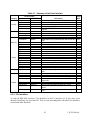
1
170-TP-500-001 HDF-EOS Library User’s Guide for the ECS Project, Volume 1: Overview and Examples Technical Paper June 1999 Prepared Under Contract NAS5-60000 RESPONSIBLE ENGINEER Larry Klein /s/ Doug Ilg, David Wynne, Raj Gejjagaraguppe, and Larry Klein EOSDIS Core System Project 6/17/99 Date SUBMITTED BY Randall J. Miller for /s/ Mary S. Armstrong, Director of Development EOSDIS Core System Project 6/17/99 Date Raytheon Systems Company Upper Marlboro, Maryland This page intentionally left blank. Preface This document is a Users Guide for HDF-EOS (Hierarchical Data Format - Earth Observing System) library tools. HDF is the scientific data format standard selected by NASA as the baseline standard for EOS. This Users Guide accompanies Version 2 software, which is available to the user community on the EDHS1 server. This library is aimed at EOS data producers and consumers, who will develop their data into increasingly higher order products. These products range from calibrated Level 1 to Level 4 model data. The primary use of the HDF-EOS library will be to create structures for associating geolocation data with their associated science data. This association is specified by producers through use of the supplied library. Most EOS data products which have been identified, fall into categories of grid, point or swath structures, which are implemented in the current version of the library. Services based on geolocation information will be built on HDF-EOS structures. Producers of products not covered by these structures, e.g. non-geolocated data, can use the standard HDF libraries. In the ECS (EOS Core System) production system, the HDF-EOS library will be used in conjunction with SDP (Science Data Processing) Toolkit software. The primary tools used in conjunction with HDF-EOS library will be those for metadata handling, process control and status message handling. Metadata tools will be used to write ECS inventory and granule specific metadata into HDF-EOS files, while the process control tools will be used to access physical file handles used by the HDF tools. (SDP Toolkit Users Guide for the ECS Project, June 1999, 333-CD-500-001). HDF-EOS is an extension of NCSA (National Center for Supercomputing Applications) HDF and uses HDF library calls as an underlying basis. Version 4.1r1 of HDF is used.The library tools are written in the C language and a Fortran interface is provided. The current version contains software for creating, accessing and manipulating Grid, Point and Swath structures. This document includes overviews of the interfaces, and code examples. EOSView, the HDFEOS viewing tool, has been revised to accommodate the current version of the library. Technical Points of Contact within EOS are: Larry Klein, [email protected] David Wynne, [email protected] Doug Ilg, dilg@ gsfc.nasa.gov An email address has been provided for user help: [email protected] Any questions should be addressed to: Data Management Office The ECS Project Office Raytheon Systems Company 1616 McCormick Drive Upper Marlboro, MD 20774-5301 iii 170-TP-500-001 This page intentionally left blank. iv 170-TP-500-001 Abstract This document will serve as the user’s guide to the HDF-EOS file access library. HDF refers to the scientific data format standard selected by NASA as the baseline standard for EOS, and HDF-EOS refers to EOS conventions for using HDF. This document will provide information on the use of the three interfaces included in HDF-EOS – Point, Swath, and Grid – including overviews of the interfaces, and code examples. This document should be suitable for use by data producers and data users alike. Keywords: HDF-EOS, Metadata, Standard Data Format, Standard Data Product, Disk Format, Point, Grid, Swath, Projection, Array, Browse v 170-TP-500-001 This page intentionally left blank. vi 170-TP-500-001 Change Information Page List of Effective Pages Page Number Issue Title Submitted as Final iii through xii Submitted as Final 1-1 and 1-2 Submitted as Final 2-1 and 2-2 Submitted as Final 3-1 and 3-2 Submitted as Final 4-1 through 4-6 Submitted as Final 5-1 through 5-8 Submitted as Final 6-1 through 6-14 Submitted as Final 7-1 through 7-48 Submitted as Final 8-1 through 8-48 Submitted as Final A-1 through A-10 Submitted as Final AB-1 through AB-4 Submitted as Final Document History Document Number Status/Issue Publication Date 170-TP-500-001 Submitted as Final June 1999 vii CCR Number 170-TP-500-001 This page intentionally left blank. viii 170-TP-500-001 Contents Preface Abstract 1. Introduction 1.1 Identification ......................................................................................1-1 1.2 Scope...............................................................................................1-1 1.3 Purpose and Objectives..........................................................................1-1 1.4 Status and Schedule ..............................................................................1-1 1.5 Document Organization .........................................................................1-2 2. Related Documentation 2.1 Parent Documents ................................................................................2-1 2.2 Related Documents...............................................................................2-1 3. Overview of HDF-EOS 3.1 Background .......................................................................................3-1 3.2 Design Philosophy ...............................................................................3-1 3.3 Packaging..........................................................................................3-2 4. Point Data 4.1 Introduction .......................................................................................4-1 4.2 Applicability ......................................................................................4-3 4.3 The Point Data Interface.........................................................................4-3 4.3.1 PT API Routines.........................................................................4-4 ix 170-TP-500-001 4.3.2 4.3.3 4.4 File Identifiers ...........................................................................4-5 Point Identifiers..........................................................................4-6 Programming Model .............................................................................4-6 5. Swath Data 5.1 Introduction .......................................................................................5-1 5.1.1 5.1.2 5.1.3 5.1.4 5.1.5 Data Fields ...............................................................................5-2 Geolocation Fields ......................................................................5-3 Dimensions...............................................................................5-3 Dimension Maps.........................................................................5-3 Index ......................................................................................5-5 5.2 Applicability ......................................................................................5-5 5.3 The Swath Data Interface .......................................................................5-5 5.3.1 5.3.2 5.3.3 5.4 SW API Routines........................................................................5-5 File Identifiers ...........................................................................5-7 Swath Identifiers.........................................................................5-7 Programming Model .............................................................................5-7 6. Grid Data 6.1 Introduction .......................................................................................6-1 6.1.1 Data Fields ...............................................................................6-2 6.1.2 Dimensions...............................................................................6-2 6.1.3 Projections................................................................................6-2 6.2 Applicability ......................................................................................6-3 6.3 The Grid Data Interface .........................................................................6-3 6.3.1 6.3.2 6.3.3 GD API Routines........................................................................6-3 File Identifiers ...........................................................................6-6 Grid Identifiers...........................................................................6-6 6.4 Programming Model .............................................................................6-6 6.5 GCTP Usage ......................................................................................6-7 6.5.1 6.5.2 GCTP Projection Codes...............................................................6-7 UTM Zone Codes .......................................................................6-8 x 170-TP-500-001 7. Examples of HDF-EOS Library Usage 7.1 Point Examples ...................................................................................7-1 7.1.1 A C Example of Creating a Simple Point ............................................7-1 7.1.2 A FORTRAN Example of Creating a Simple Point ................................7-9 7.2 Swath Examples ................................................................................. 7-14 7.2.1 Creating a Simple Swath .............................................................. 7-14 7.2.2 A 'Real World' Example of a Swath Creation ...................................... 7-29 7.3 Grid Examples ................................................................................... 7-32 7.3.1 7.4 Creating a Simple Grid ................................................................ 7-32 Combining HDF and HDF-EOS Objects .................................................... 7-46 7.4.1 Adding HDF-EOS Structures to an Existing HDF File ........................... 7-46 7.4.2 Adding an SDS to an Existing HDF File............................................ 7-46 7.4.3 Writing HDF-EOS Structures and Native HDF Objects Simultaneously ...... 7-46 8. Examples of SDP Toolkit Usage 8.1 Opening a File ....................................................................................8-1 8.1.1 A C Example of a File Open Using the SDP Toolkit ..............................8-1 8.1.2 A FORTRAN Example of a File Open Using the SDP Toolkit...................8-2 8.2 Status Message Example ........................................................................8-4 8.2.1 8.2.2 8.3 A C Example of SDP Toolkit Status Message Handling ..........................8-6 A FORTRAN Example of SDP Toolkit Status Message Handling..............8-7 Writing ODL Metadata into HDF-EOS .......................................................8-8 8.3.1. A C Example of Metadata Write .......................................................8-8 8.3.2 A FORTRAN Example of Metadata Write ......................................... 8-44 List of Figures 4-1 A Simple Point Data Example..................................................................4-1 4-2 Recording Points Over Time....................................................................4-2 4-3 Point Data from a Moving Platform ...........................................................4-3 5-1 A Typical Satellite Swath: Scanning Instrument.............................................5-1 5-2 A Swath Derived from a Profiling Instrument ...............................................5-2 xi 170-TP-500-001 5-3 A “Normal” Dimension Map ...................................................................5-4 5-4 A “Backwards” Dimension Map ...............................................................5-4 6-1 A Data Field in a Mercator-projected Grid ...................................................6-1 6-2 A Data Field in an Interrupted Goode’s Homolosine-Projected Grid .....................6-2 List of Tables 4-1 Summary of the Point Interface ................................................................4-5 5-1 Summary of the Swath Interface ...............................................................5-6 6-1 Summary of the Grid Interface .................................................................6-5 6-2 Projection Transformation Package Projection Parameters ............................... 6-10 6-3 Projection Transformation Package Projection Parameters Elements.................... 6-11 Appendix A. Installation and Maintenance Abbreviations and Acronyms xii 170-TP-500-001 1. Introduction 1.1 Identification The HDF-EOS User’s Guide for the ECS Project was prepared under the Earth Observing System Data and Information System (EOSDIS) Core System (ECS), Contract (NAS5-60000). 1.2 Scope This document is intended for use by anyone who wishes to write software to create or read EOS data products. Users of this document will likely include EOS instrument team science software developers and data product designers, DAAC personnel, and end users of EOS data products such as scientists and researchers. 1.3 Purpose and Objectives This document will serve as a user’s guide for the HDF-EOS file access library developed for ECS. Upon reading this document, the reader should have a thorough understanding of each data model and corresponding programming interface provided as part of HDF-EOS. Specifically, this user’s guide contains an overview of each data model, a complete function-by-function reference for each software interface, and sample programs illustrating the basic features of each interface. The reader should note that this paper will not discuss the HDF structures underlying HDF-EOS nor the specific conventions employed. For more information on HDF, its design philosophy, and its logical and physical formats, the reader is referred to NCSA documentation listed in Section 2.2 Applicable Documents. For more information on the conventions employed by HDF_ EOS, the reader is referred to the various design White Papers listed in Section 2.2. Important Note: The FORTRAN-literate reader is cautioned that dimension ordering is row-major in C (last dimension varying fastest), whereas FORTRAN uses column-major ordering (first dimension varying fastest). Therefore, FORTRAN programmers should take care to use dimensions in the reverse order to that shown in the text of this document. (FORTRAN code examples are correct as written.) 1.4 Status and Schedule January 1996, Prototype Library Available January 1996 Version 1 API Available March 1996, Version 1 API Frozen. 1-1 170-TP-500-001 April 1996 - Delivery of HDF-EOS Users Guide and Beta Software June 1996 - Delivery of Version 1 HDF-EOS, Release A EOSView Available , Beta 1.9 November 1996 - Delivery of Version 1.5 of the HDF-EOS Library. Release A of EOSView, Beta 2.1 Available, Delivery of SDP Toolkit Version 5.1.1 May 1997 - Delivery of Version 2.0 of the HDF-EOS Library. Release B.0 of EOSView, Beta 2.3 Available, Delivery of SDP Toolkit Version 5.2 October 1997 - Delivery of Version 2.1 of the HDF-EOS Library. Release B.0 of EOSView, Delivery of SDP Toolkit Version 5.2.1 March 1998 - Delivery of Version 2.2 of the HDF-EOS Library. Release B.0 of EOSView, Delivery of SDP Toolkit Version 5.2.2 1.5 Document Organization This document is organized as follows: • Section 1 Introduction - Presents Scope and Purpose of this document • Section 2 Related Documentation • Section 3 Overview of HDF-EOS - Background and design features of the library. • Section 4 Point Data - Design features and listing of the HDF-EOS Point Library. • Section 4 Swath Data - Design features and listing of the HDF-EOS Swath Library. • Section 6 Grid Data - Design features and listing of the HDF-EOS Grid Library. • Section 7 Examples - A selection of programming examples. • Section 8. Examples of SDP Toolkit Usage - How to use the HDF-EOS Library in conjunction with the SDP Toolkit. • Appendix A Installation Instructions, Test Drivers, User Feedback • Acronyms The accompanying Function Reference Guide is organized as follows: • Section 1 Introduction • Section 2 Function Reference - Specification of the HDF-EOS Pont, Swath and Grid • APIs • Acronyms 1-2 170-TP-500-001 2. Related Documentation 2.1 Parent Documents The following documents are the parents from which this document’s scope and content derive: 456-TP-013 The HDF-EOS Design Document for the ECS Project 170-WP-002 Thoughts on HDF-EOS Metadata, A White Paper for the ECS Project 170-WP-003 The HDF-EOS Swath Concept, A White Paper for the ECS Project 170-WP-011 The HDF-EOS Grid Concept, A White Paper for the ECS Project 170-WP-012 The HDF-EOS Point Concept, A White Paper for the ECS Project 2.2 Related Documents The following documents are referenced within this technical paper, or are directly applicable, or contain policies or other directive matters that are binding upon the content of this document. 333-CD-003 Release A SCF Toolkit Users Guide for the ECS Project 163-WP-001 An ECS Data Provider’s Guide to Metadata in Release A, A White Paper for the ECS Project 175-WP-001 HDF-EOS Primer for Version 1 EOSDIS, A White Paper for the ECS Project none Getting Started with HDF, Version 3.2, University of Illinois, May 1993 none NCSA HDF Reference Manual, Version 3.3, University of Illinois, February 1994 none NCSA HDF Specification and Developer’s Guide, Version 3.2, University of Illinois, September 1993 none NCSA HDF User’s Guide, Version 4.0, University of Illinois, February 1996 none NCSA HDF User’s Guide, Version 3.3, University of Illinois, March 1994 none An Album of Map Projections, USGS Professional Paper 1453, Snyder and Voxland, 1989 none Map Projections - A Working Manual, USGS Professional Paper 1395, Snyder, 1987 2-1 170-TP-500-001 none The WMO Format for the Storage of Weather Product Information and the Exchange of Weather Product Messages in Gridded Binary Form, John D. Stackpole, Office Note 388, GRIB Edition 1, U.S. Dept. of Commerce, NOAA, National Weather Service National Meteorological Center, Automation Division, Section 1, pp. 9-12, July 1, 1994. none The Michigan Earth Grid: Description, Registration Method for SSM/I Data, and Derivative Map Projection, John F. Galntowicz, Anthony W. England, The University of Michigan, Radiation Laborartory, Ann Arbor, Michigan, Feb. 1991. none Selection of a Map Grid for Data Analysis and Archiva, William B. Rossow, and Leonid Garder, American Meteorological Society Notes, pp. 1253-1257, Aug. 1984. none Level-3 SeaWiFS Data Products: Spatial and Temporal Binning Algorithms, Janet W. Campbell, John M. Blaisdell, and Michael Darzi, NASA Technical Memorandum 104566, GSFC, Volume 32, Appendix A, Jan. 13, 1995. 2-2 170-TP-500-001 3. Overview of HDF-EOS 3.1 Background The Hierarchical Data Format (HDF) has been selected by the EOSDIS Project as the format of choice for standard product distribution. HDF is a function library that was originally developed by the National Center for Supercomputing Applications (NCSA) at the University of Illinois at Urbana-Champaign to provide a portable storage mechanism for supercomputer simulation results. Although this user’s guide does not attempt to explain the inner workings of NCSA HDF, a cursory knowledge of HDF may help the reader to understand the basic workings of HDF-EOS. HDF files consist of a directory and a collection of data objects. Every data object has a directory entry, containing a pointer to the data object location, and information defining the datatype (much more information about HDF can be found in the NCSA documentation referenced in Section 2.2 of this Guide). Many of the NCSA defined datatypes map well to EOS datatypes. Examples include raster images, multi-dimensional arrays, and text blocks. There are other EOS datatypes, however, that do not map directly to NCSA datatypes, particularly in the case of geolocated datatypes. Examples include projected grids, satellite swaths, and field campaign or point data. Therefore, some additions to traditional HDF are required to fully support these datatypes. To bridge the gap between the needs of EOS data products and the capabilities of HDF, three new EOS specific datatypes – point, swath, and grid – have been defined within the HDF framework. Each of these new datatypes is constructed using conventions for combining standard HDF datatypes and is supported by a special application programming interface (API) which aids the data product user or producer in the application of the conventions. The APIs allow data products to be created and manipulated in ways appropriate to each datatype, without regard to the actual HDF objects and conventions underlying them. The sum of these new APIs comprise the HDF-EOS library. The Point interface is designed to support data that has associated geolocation information, but is not organized in any well defined spatial or temporal way. The Swath interface is tailored to support time-ordered data such as satellite swaths (which consist of a time-ordered series of scanlines), or profilers (which consist of a time-ordered series of profiles). The Grid interface is designed to support data that has been stored in a rectilinear array based on a well defined and explicitly supported projection. 3.2 Design Philosophy Since the HDF-EOS library is intended to support end users of EOS data as well as EOS data producers, it is essential that HDF-EOS be available separately from other ECS software. For this reason, HDF-EOS does not rely on any other ECS software, including the SDP Toolkit. It is treated as an extension to the HDF library and, as such, it follows the general design philosophy 3-1 170-TP-500-001 and coding style of HDF. For more information on the design of HDF, please refer to the appropriate NCSA documentation listed in Section 2.2. 3.3 Packaging Because of the functional overlap of HDF, HDF-EOS, and the SDP Toolkit, it is important to understand what each one contains and how they are related. NCSA HDF is a subroutine library freely available as source code from the National Center for Supercomputing Applications. The basic HDF library has its own documentation, and comes with a selection of simple utilities. HDF-EOS is a higher level library available from the ECS project as an add-on to the basic HDF library. It requires NCSA HDF for successful compiling and linking and will be widely available (at no charge) to all interested parties. Although at the time of this writing, the exact packaging has yet to be determined, the basic HDF library will also be available from the ECS project. The SDP Toolkit is a large, complex library of functions for use by EOS data producers. It presents a standard interface to Distributed Active Archive Center (DAAC) services for data processing, job scheduling, and error handling. While the SDP Toolkit may be available to individual researchers, it is unlikely to be of great use outside of EOS DAACs and Science Computing Facilities (SCF). The Toolkit distribution includes source code for both HDF and HDF-EOS. EOS instrument data producers will use the SDP Toolkit in conjunction with the HDF-EOS and HDF libraries. Of primary importance will be process control and metadata handling tools. The former will be used to access physical file handles required by the HDF library. The SDP Toolkit uses logical file handles to access data, while HDF (HDF-EOS) requires physical handles. Users will be required to make one additional call, using the SDP toolkit to access the physical handles. Please refer to the SDP Toolkit Users Guide for the ECS Project, Mar, 1998, 333-CD-100-001, Section 6.2.1.2 for an example). Section 7 of this document gives examples of HDF-EOS usage in conjunction with the SDP Toolkit. Metadata tools will be used to access and write inventory and granule specific metadata into their designated HDF structures. Please refer to Section 6.2.1.4 of the SDP Toolkit Users Guide. We make an important distinction between granule metadata and the structural metadata referred to in the software description below. Structural metadata specifies the internal HDF-EOS file structure and the relationship between geolocation data and the data itself. Structural metadata is created and then accessed by calling the HDF-EOS functions. Granule metadata will be used by ECS to perform archival services on the data. A copy will attached to HDF-EOS files by SDP toolkit calls and another copy is placed in the ECS archives. The two sets of metadata are not dynamically linked. However, the data producer should use consistent naming conventions when writing granule metadata when calling the HDF-EOS API. Please refer to the examples in Section 7, below. NCSA HDF libraries, on which HDF-EOS is based, is installed automatically with the SDP Toolkit installation script. Please refer to The SDP Toolkit Users Guide for the ECS Project, Section 5 for information pertaining installation and maintenance of the SDP Toolkit. 3-2 170-TP-500-001 4. Point Data 4.1 Introduction This section will describe the routines available for storing and retrieving HDF-EOS Point Data. A Point Data set is made up of a series of data records taken at [possibly] irregular time intervals and at scattered geographic locations. Point Data is the most loosely organized form of geolocated data supported by HDF-EOS. Simply put, each data record consists of a set of one or more data values representing, in some sense, the state of a point in time and/or space. Figure 4-1 shows an example of a simple point data set. In this example, each star on the map represents a reporting station. Each record in the data table contains the location of the point on the Earth and the measurements of the temperature and dew point at that location. This sort of point data set might represent a snapshot in time of a network of stationary weather reporting facilities. Lat 61.12 45.31 38.50 38.39 30.00 37.45 18.00 43.40 34.03 32.45 33.30 42.15 35.05 34.12 46.32 47.36 39.44 21.25 44.58 41.49 25.45 Lon -149.48 -122.41 -77.00 -90.15 -90.05 -122.26 -76.45 -79.23 -118.14 -96.48 -112.00 -71.07 -106.40 -77.56 -87.25 -122.20 -104.59 -78.00 -93.15 -87.37 -80.11 Temp(C) 15.00 17.00 24.00 27.00 22.00 25.00 27.00 30.00 25.00 32.00 30.00 28.00 30.00 28.00 30.00 32.00 31.00 28.00 32.00 28.00 19.00 Dewpt(C) 5.00 5.00 7.00 11.00 7.00 10.00 4.00 14.00 4.00 8.00 10.00 7.00 9.00 9.00 8.00 15.00 16.00 7.00 13.00 9.00 3.00 Figure 4-1. A Simple Point Data Example 4-1 170-TP-500-001 A more realistic example might record the changes in the parameters over time by including multiple values of the parameters for each location. In this case, the identity and location of the reporting stations would remain constant, while the values of the measured parameters would vary. This sort of set up naturally leads to a hierarchical table arrangement where a second table is used to record the static information about each reporting station, thereby removing the redundant information that would be required by a single “flat” table and acting as an index for quick access to the main data table. Such an arrangement is depicted in Figure 4-2. Station Chicago Los Angeles Washington Miami Time 0800 0900 1000 0800 0900 1000 1100 1000 1100 1200 1300 1400 0600 0700 Lat Lon 41.49 -87.37 34.03 -118.14 38.50 -77.00 25.45 -80.11 Temp(C) -3 -2 -1 20 21 22 24 6 8 9 11 12 15 16 Figure 4-2. Recording Points Over Time An even more complex point data set may represent data taken at various times aboard a moving ship. Here, the only thing that remains constant is the identity of the reporting ship. Its location varies with each data reading and is therefore treated similarly to the data. Although this example seems more complicated than the static example cited above, its implementation is nearly identical. Figure 4-3 shows the tables resulting from this example. Note that the station location information has been moved from the static table to the data table. 4-2 170-TP-500-001 Ship ID SS Botany Bay SS Dinghy SS Botany Bay Lat 34.12 33.24 32.45 32.03 30.94 30.04 29.88 25.51 25.97 26.22 26.53 26.58 26.62 26.87 27.09 Lon -74.56 -74.62 -75.65 -76.02 -76.48 -76.89 -76.94 -84.67 -85.06 -85.65 -86.14 -86.74 -87.45 -87.97 -88.68 Temp(C) 18 18 19 19 20 20 21 26 26 25 26 27 27 25 25 Salinity(PPM) 146 158 151 160 162 165 159 167 173 168 162 144 156 160 166 SS Dinghy Figure 4-3. Point Data from a Moving Platform In fact, the hierarchical arrangement of the tables in the last two examples can be expanded upon to include up to seven indexing levels (a total of eight levels, including the bottom level data table). A normal data access on a multi-level hierarchical point data set would involve starting at the top (first) level and following successive pointers down the structure until the desired information is found. As each level is traversed, more and more specific information is gained about the data. In rare cases, it may be advantageous to access a point data set from the bottom up. The point data model implemented in HDF-EOS provides for backward (or upward) pointers which facilitate bottom-up access. 4.2 Applicability The Point data model is very flexible and can be used for data at almost any level of processing. It is expected that point structure will be used for data for which there is no spatial or temporal organization, although lack of those characteristics do not preclude the use of a point structure. For example, profile data which is accumulated in sparsely located spatial averages may be most useful in a point structure. 4.3 The Point Data Interface The PT interface consists of routines for storing, retrieving, and manipulating data in point data sets. 4-3 170-TP-500-001 4.3.1 PT API Routines All C routine names in the point data interface have the prefix “PT” and the equivalent FORTRAN routine names are prefixed by “pt.” The PT routines are classified into the following categories: • Access routines initialize and terminate access to the PT interface and point data sets (including opening and closing files). • Definition routines allow the user to set key features of a point data set. • Basic I/O routines read and write data and metadata to a point data set. • Index I/O routines read and write information which links two tables in a point data set. • Inquiry routines return information about data contained in a point data set. • Subset routines allow reading of data from a specified geographic region. The PT function calls are listed in Table 4-1 and are described in detail in the Software Reference Guide that accompanies this document. The page number column in the following table refers to the Software Reference Guide. 4-4 170-TP-500-001 Table 4-1. Summary of the Point Interface Routine Name Category C PTopen Ptcreate PTattach PTdetach PTclose FORTRAN ptopen ptcreate ptattach ptdetach ptclose Definition PTdeflevel PTdeflinkage Ptdefvrtregion PTwritelevel PTreadlevel ptdeflev ptdeflink ptdefvrtreg ptwrlev ptrdlev Basic I/O PTupdatelevel PTwriteattr PTreadattr PTnlevels PTnrecs PTnfields PTlevelinfo PTlevelindx PTbcklinkinfo PTfwdlinkinfo PTgetlevelname PTsizeof PTattrinfo PTinqattrs PTinqpoint PTgetrecnums ptuplev ptwrattr ptrdattr ptnlevs ptnrecs ptnflds ptnlevinfo ptlevidx ptblinkinfo ptflinkinfo ptgetlevname ptsizeof ptattrinfo ptinqattrs ptinqpoint ptgetrecnums PTdefboxregion PTregioninfo PTregionrecs PTextractregion ptdefboxreg ptreginfo ptregrecs ptextreg PTdeftimeperiod PTperiodinfo PTperiodrecs ptdeftmeper ptperinfo ptperrecs PTextractperiod ptextper Access Inquiry Utility Subset Page Description creates a new file or opens an existing one creates a new point data set and returns a handle attaches to an existing point data set releases a point data set and frees memory closes the HDF-EOS file and deactivates the point interface defines a level within the point data set defines link field to use between two levels defines a vertical subset region writes (appends) full records to a level reads data from the specified fields and records of a level updates the specified fields and records of a level creates or updates an attribute of the point data set reads existing attribute of point data set returns the number of levels in a point data set returns the number of records in a level returns number of fields defined in a level returns information about a given level returns index number for a named level returns link field to previous level returns link field to following level returns level name given level number returns size in bytes for specified fields in a point returns information about point attributes retrieves number and names of attributes defined retrieves number and names of points in file returns corresponding record numbers in a related level define region of interest by latitude/longitude returns information about defined region returns # of records and record #s within region read a region of interest from a set of fields in a single level define time period of interest returns information about defined time period returns # of records and record #s within time period read a time period from a set of fields in a single level Nos. 2-30 2-6 2-2 2-15 2-5 2-8 2-10 2-13 2-43 2-34 2-39 2-41 2-33 2-28 2-29 2-27 2-25 2-24 2-4 2-18 2-19 2-38 2-3 2-22 2-23 2-20 2-7 2-36 2-37 2-17 2-11 2-31 2-32 2-16 4.3.2 File Identifiers As with all HDF-EOS interfaces, file identifiers in the PT interface are 32-bit values, each uniquely identifying one open data file. They are not interchangeable with other file identifiers created with other interfaces. 4-5 170-TP-500-001 4.3.3 Point Identifiers Before a point data set is accessed, it is identified by a name which is assigned to it upon its creation. The name is used to obtain a point identifier. After a point data set has been opened for access, it is uniquely identified by its point identifier. 4.4 Programming Model The programming model for accessing a point data set through the PT interface is as follows: 1. Open the file and initialize the PT interface by obtaining a file id from a file name. 2. Open OR create a point data set by obtaining a point id from a point name. 3. Perform desired operations on the data set. 4. Close the point data set by disposing of the point id. 5. Terminate point access to the file by disposing of the file id. To access a single point data set that already exists in an HDF-EOS file, the calling program must contain the following sequence of C calls: file_id = PTopen(filename, access_mode); pt_id = PTattach(file_id, point_name); <Optional operations> status = PTdetach(pt_id); status = PTclose(file_id); To access several files at the same time, a calling program must obtain a separate id for each file to be opened. Similarly, to access more than one point data set, a calling program must obtain a separate point id for each data set. For example, to open two data sets stored in two files, a program would execute the following series of C function calls: file_id_1 = PTopen(filename_1, access_mode); pt_id_1 = PTattach(file_id_1, point_name_1); file_id_2 = PTopen(filename_2, access_mode); pt_id_2 = PTattach(file_id_2, point_name_2); <Optional operations> status = PTdetach(pt_id_1); status = PTclose(file_id_1); status = PTdetach(pt_id_2); status = PTclose(file_id_2); Because each file and point data set is assigned its own identifier, the order in which files and data sets are accessed is very flexible. However, it is very important that the calling program individually discard each identifier before terminating. Failure to do so can result in empty or, even worse, invalid files being produced. 4-6 170-TP-500-001 5. Swath Data 5.1 Introduction The Swath concept for HDF-EOS is based on a typical satellite swath, where an instrument takes a series of scans perpendicular to the ground track of the satellite as it moves along that ground track. Figure 5-1 below shows this traditional view of a swath. Satellite Along Track Cross Track Scan Lines Figure 5-1. A Typical Satellite Swath: Scanning Instrument Another type of data that the Swath is equally well suited to arises from a sensor that measures a vertical profile, instead of scanning across the ground track. The resulting data resembles a standard Swath tipped up on its edge. Figure 5-2 shows how such a Swath might look. In fact, the two approaches shown in Figures 5-1 and 5-2 can be combined to manage a profiling instrument that scans across the ground track. The result would be a three dimensional array of measurements where two of the dimensions correspond to the standard scanning dimensions (along the ground track and across the ground track), and the third dimension represents a height above the Earth or a range from the sensor. The "horizontal" dimensions can be handled as normal geographic dimensions, while the third dimension can be handled as a special "vertical" dimension. 5-1 170-TP-500-001 th Pa en t st ru m In Profiles Instrument Along Track Figure 5-2. A Swath Derived from a Profiling Instrument A standard Swath is made up of four primary parts: data fields, geolocation fields, dimensions, and dimension maps. An optional fifth part called an index can be added to support certain kinds of access to Swath data. Each of the parts of a Swath is described in detail in the following subsections. 5.1.1 Data Fields Data fields are the main part of a Swath from a science perspective. Data fields usually contain the raw data (often as counts) taken by the sensor or parameters derived from that data on a value-for-value basis. All the other parts of the Swath exist to provide information about the data fields or to support particular types of access to them. Data fields typically are two-dimensional arrays, but can have as few as one dimension or as many as eight, in the current library implementation. They can have any valid C data type. 5-2 170-TP-500-001 5.1.2 Geolocation Fields Geolocation fields allow the Swath to be accurately tied to particular points on the Earth’s surface. To do this, the Swath interface requires the presence of at least a time field (“Time”) or a latitude/longitude field pair (“Latitude”1 and “Longitude”). Geolocation fields must be either one- or two-dimensional and can have any data type. 5.1.3 Dimensions Dimensions define the axes of the data and geolocation fields by giving them names and sizes. In using the library, dimensions must be defined before they can be used to describe data or geolocation fields. Every axis of every data or geolocation field, then, must have a dimension associated with it. However, there is no requirement that they all be unique. In other words, different data and geolocation fields may share the same named dimension. In fact, sharing dimension names allows the Swath interface to make some assumptions about the data and geolocation fields involved which can reduce the complexity of the file and simplify the program creating or reading the file. 5.1.4 Dimension Maps Dimension maps are the glue that holds the Swath together. They define the relationship between data fields and geolocation fields by defining, one-by-one, the relationship of each dimension of each geolocation field with the corresponding dimension in each data field. In cases where a data field and a geolocation field share a named dimension, no explicit dimension map is needed. In cases where a data field has more dimensions than the geolocation fields, the “extra” dimensions are left unmapped. In many cases, the size of a geolocation dimension will be different from the size of the corresponding data dimension. To take care of such occurrences, there are two pieces of information that must be supplied when defining a dimension map: the offset and the increment. The offset tells how far along a data dimension you must travel to find the first point to have a corresponding entry along the geolocation dimension. The increment tells how many points to travel along the data dimension before the next point is found for which there is a corresponding entry along the geolocation dimension. Figure 5-3 depicts a dimension map. 1 “Co-latitude” may be substituted for “Latitude.” 5-3 170-TP-500-001 Geolocation Dimension 0 1 2 3 4 5 6 7 8 9 Mapping Offset: 1 Increment: 2 0 1 2 3 4 5 6 7 8 9 10111213141516171819 Data Dimension Figure 5-3. A “Normal” Dimension Map The “data skipping” method described above works quite well if there are fewer regularly spaced geolocation points than data points along a particular pair of mapped dimensions of a Swath. It is conceivable, however, that the reverse is true – that there are more regularly spaced geolocation points than data points. In that event, both the offset and increment should be expressed as negative values to indicate the reversed relationship. The result is shown in Figure 5-4. Note that in the reversed relationship, the offset and increment are applied to the geolocation dimension rather than the data dimension. GeolocationDimension 0 1 2 3 4 5 6 7 8 9 10111213141516171819 0 1 2 3 4 5 6 7 8 9 Data Dimension Mapping Offset: -1 Increment: -2 Figure 5-4. A “Backwards” Dimension Map 5-4 170-TP-500-001 5.1.5 Index The index was designed specifically for Landsat 7 data products. These products require geolocation information that does not repeat at regular intervals throughout the Swath. The index allows the Swath to be broken into unequal length scenes which can be individually geolocated. For this version of the HDF-EOS library, there is no particular content required for the index. It is quite likely that a later version of the library will impose content requirements on the index in an effort to standardize its use. 5.2 Applicability The Swath data model is most useful for satellite [or similar] data at a low level of processing. The Swath model is best suited to data at EOS processing levels 1A, 1B, and 2. 5.3 The Swath Data Interface The SW interface consists of routines for storing, retrieving, and manipulating data in swath data sets. 5.3.1 SW API Routines All C routine names in the swath data interface have the prefix “SW” and the equivalent FORTRAN routine names are prefixed by “sw.” The SW routines are classified into the following categories: • Access routines initialize and terminate access to the SW interface and swath data sets (including opening and closing files). • Definition routines allow the user to set key features of a swath data set. • Basic I/O routines read and write data and metadata to a swath data set. • Inquiry routines return information about data contained in a swath data set. • Subset routines allow reading of data from a specified geographic region. The SW function calls are listed in Table 5-1 and are described in detail in the Software Reference Guide that accompanies this document. The page number column in the following table refers to the Software Reference Guide. 5-5 170-TP-500-001 Table 5-1. Summary of the Swath Interface (1 of 2) Routine Name Category Access Definition Basic I/O Inquiry C SWopen FORTRAN swopen SWcreate SWattach SWdetach SWclose SWdefdim SWdefdimmap swcreate swattach swdetach swclose swdefdim swdefmap SWdefidxmap swdefimap SWdefgeofield SWdefdatafield SWdefcomp SWwritegeometa swdefgfld swdefdfld swdefcomp swwrgmeta SWwritedatameta swwrdmeta SWwritefield SWreadfield SWwriteattr SWreadattr SWsetfillvalue SWgetfillvalue SWinqdims swwrfld swrdfld swwrattr swrdattr swsetfill swgetfill swinqdims SWinqmaps swinqmaps SWinqidxmaps swinqimaps SWinqgeofields swinqgflds SWinqdatafields SWinqattrs SWnentries swinqdflds swinqattrs swnentries SWdiminfo SWmapinfo swdiminfo swmapinfo SWidxmapinfo swimapinfo SWattrinfo SWfieldinfo swattrinfo swfldinfo SWcompinfo SWinqswath Swregionindex SWupdateidxmap swcompinfo swinqswath swregidx swupimap Page Description opens or creates HDF file in order to create, read, or write a swath creates a swath within the file attaches to an existing swath within the file detaches from swath interface closes file defines a new dimension within the swath defines the mapping between the geolocation and data dimensions defines a non-regular mapping between the geolocation and data dimension defines a new geolocation field within the swath defines a new data field within the swath defines a field compression scheme writes field metadata for an existing swath geolocation field writes field metadata for an existing swath data field writes data to a swath field reads data from a swath field. writes/updates attribute in a swath reads attribute from a swath sets fill value for the specified field retrieves fill value for the specified field retrieves information about dimensions defined in swath retrieves information about the geolocation relations defined retrieves information about the indexed geolocation/data mappings defined retrieves information about the geolocation fields defined retrieves information about the data fields defined retrieves number and names of attributes defined returns number of entries and descriptive string buffer size for a specified entity retrieve size of specified dimension retrieve offset and increment of specified geolocation mapping retrieve offset and increment of specified geolocation mapping returns information about swath attributes retrieve information about a specific geolocation or data field retrieve compression information about a field retrieves number and names of swaths in file Returns information about the swath region ID update map index for a specified region 5-6 Nos. 2-87 2-48 2-44 2-66 2-46 2-55 2-56 2-60 2-58 2-53 2-51 2-106 2-102 2-103 2-91 2-100 2-90 2-97 2-75 2-80 2-83 2-82 2-81 2-79 2-78 2-86 2-67 2-85 2-77 2-45 2-73 2-47 2-84 2-93 2-98 170-TP-500-001 Table 5-1. Summary of the Swath Interface (2 of 2) Routine Name Category Subset C Swgeomapinfo SWdefboxregion SWregioninfo SWextractregion SWdeftimeperiod SWperiodinfo SWextractperiod SWdefvrtregion SWdupregion Page FORTRAN swgmapinfo Description retrieves type of dimension mapping when first dimension is geodim swdefboxreg define region of interest by latitude/longitude swreginfo returns information about defined region swextreg read a region of interest from a field swdeftmeper define a time period of interest swperinfo retuns information about a defined time period swextper extract a defined time period swdefvrtreg define a region of interest by vertical field swdupreg duplicate a region or time period Nos. 2-76 2-49 2-95 2-71 2-61 2-88 2-70 2-63 2-68 5.3.2 File Identifiers As with all HDF-EOS interfaces, file identifiers in the SW interface are 32-bit values, each uniquely identifying one open data file. They are not interchangeable with other file identifiers created with other interfaces. 5.3.3 Swath Identifiers Before a swath data set is accessed, it is identified by a name which is assigned to it upon its creation. The name is used to obtain a swath identifier. After a swath data set has been opened for access, it is uniquely identified by its swath identifier. 5.4 Programming Model The programming model for accessing a swath data set through the SW interface is as follows: 1. 2. 3. 4. 5. Open the file and initialize the SW interface by obtaining a file id from a file name. Open OR create a swath data set by obtaining a swath id from a swath name. Perform desired operations on the data set. Close the swath data set by disposing of the swath id. Terminate swath access to the file by disposing of the file id. To access a single swath data set that already exists in an HDF-EOS file, the calling program must contain the following sequence of C calls: file_id = SWopen(filename, access_mode); sw_id = SWattach(file_id, swath_name); <Optional operations> status = SWdetach(sw_id); status = SWclose(file_id); 5-7 170-TP-500-001 To access several files at the same time, a calling program must obtain a separate id for each file to be opened. Similarly, to access more than one swath data set, a calling program must obtain a separate swath id for each data set. For example, to open two data sets stored in two files, a program would execute the following series of C function calls: file_id_1 = SWopen(filename_1, access_mode); sw_id_1 = SWattach(file_id_1, swath_name_1); file_id_2 = SWopen(filename_2, access_mode); sw_id_2 = SWattach(file_id_2, swath_name_2); <Optional operations> status = SWdetach(sw_id_1); status = SWclose(file_id_1); status = SWdetach(sw_id_2); status = SWclose(file_id_2); Because each file and swath data set is assigned its own identifier, the order in which files and data sets are accessed is very flexible. However, it is very important that the calling program individually discard each identifier before terminating. Failure to do so can result in empty or, even worse, invalid files being produced. 5-8 170-TP-500-001 6. Grid Data 6.1 Introduction This section will describe the routines available for storing and retrieving HDF-EOS Grid Data. A Grid data set is similar to a swath in that it contains a series of data fields of two or more dimensions. The main difference between a Grid and a Swath is in the character of their geolocation information. As described in Section 5, swaths carry geolocation information as a series of individually located points (tie points or ground control points). Grids, though, carry their geolocation in a much more compact form. A grid merely contains a set of projection equations (or references to them) along with their relevant parameters. Together, these relatively few pieces of information define the location of all points in the grid. The equations and parameters can then be used to compute the latitude and longitude for any point in the grid. Figure 6-1. A Data Field in a Mercator-projected Grid In loose terms, each data field constitutes a map in a given standard projection. Although there may be many independent Grids in a single HDF-EOS file, within each Grid only one projection may be chosen for application to all data fields. Figures 6-1 and 6-2 show how a single data field may look in a Grid using two common projections. There are three important features of a Grid data set: the data fields, the dimensions, and the projection. Each of these is discussed in detail in the following subsections. 6-1 170-TP-500-001 Figure 6-2. A Data Field in an Interrupted Goode’s Homolosine-Projected Grid 6.1.1 Data Fields The data fields are, of course, the most important part of the Grid. Data fields in a Grid data set are rectilinear arrays of two or more dimensions. Most commonly, they are simply twodimensional rectangular arrays. Generally, each field contains data of similar scientific nature which must share the same data type. The data fields are related to each other by common geolocation. That is, a single set of geolocation information is used for all data fields within one Grid data set. 6.1.2 Dimensions Dimensions are used to relate data fields to each other and to the geolocation information. To be interpreted properly, each data field must make use of the two predefined dimensions: “XDim” and “YDim”. These two dimensions are defined when the grid is created and are used to refer to the X and Y dimensions of the chosen projection (see 6.1.3 below). Although there is no practical limit on the number of dimensions a data field in a Grid data set my have, it is not likely that many fields will need more than three: the predefined dimensions “XDim” and “YDim” and a third dimension for depth or height. 6.1.3 Projections The projection is really the heart of the Grid. Without the use of a projection, the Grid would not be substantially different from a Swath. The projection provides a convenient way to encode geolocation information as a set of mathematical equations which are capable of transforming Earth coordinates (latitude and longitude) to X-Y coordinates on a sheet of paper. 6-2 170-TP-500-001 The choice of a projection to be used for a Grid is a critical decision for a data product designer. There is a large number of projections that have been used throughout history. In fact, some projections date back to ancient Greece. For the purposes of this release of HDF-EOS, however, only six families of projections are supported: Geographic, Interrupted Goode’s Homolosine, Polar Stereographic, Universal Transverse Mercator, Space Oblique, and Lambert Azimuthal Equal Area. These projections coincide with those supported by the SDP Toolkit for ECS Release B. The producer’s choice of a projection should be governed by knowledge of the specific properties of each projection and a thorough understanding of the requirements of the data set’s users. Two excellent resources for information on projections and their properties are the USGS Professional Papers cited in Section 2.2 “Related Documents.” This release of HDF-EOS assumes that the data producer will use to create the data the General Coordinate Transformation Package (GCTP), a library of projection software available from the U.S. Geological Survey. This manual will not attempt to explain the use of GCTP. Adequate documentation accompanies the GCTP source code. For the purposes of this Grid interface, the data are assumed to have already been projected. The Grid interface allows the data producer to specify the exact GCTP parameters used to perform the projection and will provide for basic subsetting of the data fields by latitude/longitude bounding box. See section below for further details on the usage of the GCTP package. 6.2 Applicability The Grid data model is intended for data processed at a high level. It is most applicable to data at EOS processing levels 3 and 4. 6.3 The Grid Data Interface The GD interface consists of routines for storing, retrieving, and manipulating data in grid data sets. 6.3.1 GD API Routines All C routine names in the grid data interface have the prefix “GD” and the equivalent FORTRAN routine names are prefixed by “gd.” The GD routines are classified into the following categories: • Access routines initialize and terminate access to the GD interface and grid data sets (including opening and closing files). • Definition routines allow the user to set key features of a grid data set. • Basic I/O routines read and write data and metadata to a grid data set. • Inquiry routines return information about data contained in a grid data set. • Subset routines allow reading of data from a specified geographic region. 6-3 170-TP-500-001 The GD function calls are listed in Table 6-1 and are described in detail in the Software Reference Guide that accompanies this document. The page number column in the following table refers to the Software Reference Guide. 6-4 170-TP-500-001 Table 6-1. Summary of the Grid Interface (1 of 2) Routine Name Category Access Definition Basic I/O Inquiry Page C GDopen GDcreate GDattach GDdetach GDclose Gddeforigin FORTRAN gdopen gdcreate gdattach gddetach gdclose gddeforigin Description creates a new file or opens an existing one creates a new grid in the file attaches to a grid detaches from grid interface closes file defines origin of grid Nos. 2-153 2-114 2-108 2-134 2-112 2-123 Gddefdim gddefdim defines dimensions for a grid 2-120 GDdefproj gddefproj defines projection of grid 2-125 GDdefpixreg GDdeffield GDdefcomp GDblkSOMoffset gddefpixreg gddeffld gddefcomp none 2-124 2-121 2-118 2-110 GDsettilecomp none GDwritefieldmeta GDwritefield GDreadfield GDwriteattr GDreadattr GDsetfillvalue GDgetfillvalue GDinqdims gdwrmeta gdwrfld gdrdfld gdwrattr gdrdattr gdsetfill gdgetfill gdinqdims GDinqfields gdinqdflds GDinqattrs GDnentries gdinqattrs gdnentries GDgridinfo gdgridinfo GDprojinfo GDdiminfo GDcompinfo GDfieldinfo gdprojinfo gddiminfo gdcompinfo gdfldinfo GDinqgrid GDattrinfo GDorigininfo GDpixreginfo GDdefboxregion GDregioninfo gdinqgrid gdattrinfo gdorginfo gdpreginfo gddefboxreg gdreginfo defines pixel registration within grid cell defines data fields to be stored in a grid defines a field compression scheme This is a special function for SOM MISR data. Write block SOM offset values. This routine was added as a fix to a bug in HDFEOS. The current method of implementation didn’t allow the user to have a field with fill values and use tiling and compression. This function allows the user to access all of these features. writes metadata for field already existing in file writes data to a grid field. reads data from a grid field writes/updates attribute in a grid. reads attribute from a grid sets fill value for the specified field retrieves fill value for the specified field retrieves information about dimensions defined in grid retrieves information about the data fields defined in grid retrieves number and names of attributes defined returns number of entries and descriptive string buffer size for a specified entity returns dimensions of grid and X-Y coordinates of corners returns all GCTP projection information retrieves size of specified dimension. retrieve compression information about a field retrieves information about a specific geolocation or data field in the grid retrieves number and names of grids in file returns information about grid attributes return information about grid origin return pixel registration information for given grid define region of interest by latitude/longitude returns information about a defined region 6-5 2-165 2-172 2-170 2-158 2-168 2-157 2-163 2-140 2-147 2-148 2-146 2-152 2-145 2-156 2-135 2-113 2-138 2-149 2-109 2-154 2-155 2-117 2-161 170-TP-500-001 Table 6-1. Summary of the Grid Interface (2 of 2) Routine Name Category Subset Tiling C GDextractregion GDdeftimeperiod GDdefvrtregion GDgetpixels GDgetpixvalues GDinterpolate GDdupregion GDdeftile GDtileinfo GDsettilecache GDreadtile GDwritetile FORTRAN gdextrreg gddeftmeper gddefvrtreg gdgetpix gdgetpixval gdinterpolate gddupreg gddeftle gdtleinfo gdsettleche gdrdtle gdwrtile Page Description read a region of interest from a field define a time period of interest define a region of interest by vertical field get row/columns for lon/lat pairs get field values for specified pixels perform bilinear interpolation on a grid field duplicate a region or time period define a tiling scheme returns information about tiling for a field set tiling cache parameters read data from a single tile write data to a single tile Nos. 2-137 2-129 2-131 2-141 2-143 2-150 2-136 2-127 2-166 2-164 2-160 2-173 6.3.2 File Identifiers As with all HDF-EOS interfaces, file identifiers in the GD interface are 32-bit values, each uniquely identifying one open data file. They are not interchangeable with other file identifiers created with other interfaces. 6.3.3 Grid Identifiers Before a grid data set is accessed, it is identified by a name which is assigned to it upon its creation. The name is used to obtain a grid identifier. After a grid data set has been opened for access, it is uniquely identified by its grid identifier. 6.4 Programming Model The programming model for accessing a grid data set through the GD interface is as follows: 1. Open the file and initialize the GD interface by obtaining a file id from a file name. 2. Open OR create a grid data set by obtaining a grid id from a grid name. 3. Perform desired operations on the data set. 4. Close the grid data set by disposing of the grid id. 5. Terminate grid access to the file by disposing of the file id. To access a single grid data set that already exists in an HDF-EOS file, the calling program must contain the following sequence of C calls: file_id = GDopen(filename, access_mode); gd_id = GDattach(file_id, grid_name); <Optional operations> status = GDdetach(gd_id); status = GDclose(file_id); 6-6 170-TP-500-001 To access several files at the same time, a calling program must obtain a separate id for each file to be opened. Similarly, to access more than one grid data set, a calling program must obtain a separate grid id for each data set. For example, to open two data sets stored in two files, a program would execute the following series of C function calls: file_id_1 = GDopen(filename_1, access_mode); gd_id_1 = GDattach(file_id_1, grid_name_1); file_id_2 = GDopen(filename_2, access_mode); gd_id_2 = GDattach(file_id_2, grid_name_2); <Optional operations> status = GDdetach(gd_id_1); status = GDclose(file_id_1); status = GDdetach(gd_id_2); status = GDclose(file_id_2); Because each file and grid data set is assigned its own identifier, the order in which files and data sets are accessed is very flexible. However, it is very important that the calling program individually discard each identifier before terminating. Failure to do so can result in empty or, even worse, invalid files being produced. 6.5 GCTP Usage The HDF-EOS Grid API uses the U.S. Geological Survey General Cartographic Transformation Package (GCTP) to define and subset grid structures. This section described codes used by the package. 6.5.1 GCTP Projection Codes The following GCTP projection codes are used in the grid API described in Section 7 below: GCTP_GEO (0) Geographic GCTP_UTM (1) Universal Transverse Mercator GCTP_LAMCC (4) Lambert Conformal Conic GCTP_PS (6) Polar Stereographic GCTP_POLYC (7) Polyconic GCTP_TM (9) Transverse Mercator GCTP_LAMAZ (11) Lambert Azimuthal Equal Area GCTP_HOM (20) Hotine Oblique Mercator GCTP_SOM (22) Space Oblique Mercator GCTP_GOOD (24) Interrupted Goode Homolosine GCTP_ISINUS (99) Intergerized Sinusoidal Projection* * The Intergerized Sinusoidal Projection is not part of the original GCTP package. It has been added by ECS. See Level-3 SeaWiFS Data Products: Spatial and Temporal Binning Algorithms. Additional references are provided in Section 2. 6-7 170-TP-500-001 Note that other projections supported by GCTP will be adapted for HDF-EOS Version 2.2s new user requirements are surfaced. For further details on the GCTP projection package, please refer to Section 6.3.4 and Appendix G of the SDP Toolkit Users Guide for the ECS Project, June 1998, (333-CD-500-001) 6.5.2 UTM Zone Codes The Universal Transverse Mercator (UTM) Coordinate System uses zone codes instead of specific projection parameters. The table that follows lists UTM zone codes as used by GCTP Projection Transformation Package. C.M. is Central Meridian Zone C.M. Range Zone 01 177W 180W-174W 31 003E 000E-006E 02 171W 174W-168W 32 009E 006E-012E 03 165W 168W-162W 33 015E 012E-018E 04 159W 162W-156W 34 021E 018E-024E 05 153W 156W-150W 35 027E 024E-030E 06 147W 150W-144W 36 033E 030E-036E 07 141W 144W-138W 37 039E 036E-042E 08 135W 138W-132W 38 045E 042E-048E 09 129W 132W-126W 39 051E 048E-054E 10 123W 126W-120W 40 057E 054E-060E 11 117W 120W-114W 41 063E 060E-066E 12 111W 114W-108W 42 069E 066E-072E 13 105W 108W-102W 43 075E 072E-078E 14 099W 102W-096W 44 081E 078E-084E 15 093W 096W-090W 45 087E 084E-090E 16 087W 090W-084W 46 093E 090E-096E 17 081W 084W-078W 47 099E 096E-102E 18 075W 078W-072W 48 105E 102E-108E 19 069W 072W-066W 49 111E 108E-114E 20 063W 066W-060W 50 117E 114E-120E 21 057W 060W-054W 51 123E 120E-126E 22 051W 054W-048W 52 129E 126E-132E 23 045W 048W-042W 53 135E 132E-138E 6-8 C.M. Range 170-TP-500-001 24 039W 042W-036W 54 141E 138E-144E 25 033W 036W-030W 55 147E 144E-150E 26 027W 030W-024W 56 153E 150E-156E 27 021W 024W-018W 57 159E 156E-162E 28 015W 018W-012W 58 165E 162E-168E 29 009W 012W-006W 59 171E 168E-174E 30 003W 006W-000E 60 177E 174E-180W 6.5.3 GCTP Spheroid Codes Clarke 1866 (default) (0) Clarke 1880 (1) Bessel (2) International 1967 (3) International 1909 (4) WGS 72 (5) Everest (6) WGS 66 (7) GRS 1980 (8) Airy (9) Modified Airy (10) Modified Everest (11) WGS 84 (12) Southeast Asia (13) Austrailian National (14) Krassovsky (15) Hough (16) Mercury 1960 (17) Modified Mercury 1968 (18) Sphereof Radius 6370997m(19) 6-9 170-TP-500-001 6.5.4 Projection Parameters Table 6-2. Projection Transformation Package Projection Parameters Array Element Code & Projection Id 1 0 Geographic 1UTM Lon/Z 4 Lambert Conformal SMajor C 6 Polar Stereographic SMajor 7 Polyconic SMajor 9 Transverse SMajor Mercator 11 Lambert Azimuthal Sphere 20 Hotin Oblique SMajor Merc A 20 Hotin Oblique SMajor Merc B 22 Space Oblique SMajor Merc A 22 Space Oblique SMajor Merc B 24 Interrupted Goode Sphere 99 Integerized Sphere Sinusoidal 2 3 4 5 Lat/Z SMinor STDPR1 STDPR2 CentMer SMinor SMinor SMinor Factor SMinor Factor SMinor Factor SMinor SMinor Satnum 7 8 OriginLat FE FN LongPol CentMer CentMer TrueScale OriginLat OriginLat FE FE FE FN FN FN CentLon CenterLat OriginLat FE FE FN FN AziAng AzmthPt OriginLat FE FN IncAng AscLon g FE FN FE FN FE FN Path CentMer 6-10 6 170-TP-500-001 Table 6-3. Projection Transformation Package Projection Parameters Elements Array Element Code & Projection Id 0 Geographic 1UTM 4 Lambert Conformal C 6 Polar Stereographic 7 Polyconic 9 Transverse Mercator 11 Lambert Azimuthal 20 Hotin Oblique Merc A 20 Hotin Oblique Merc B 22 Space Oblique Merc A 22 Space Oblique Merc B 24 Interrupted Goode 99 Integerized Sinusoidal 9 10 11 Long1 Lat1 Long2 PSRev SRat PFlag NZone 12 Lat2 13 zero one zero one RFlag Where, Lon/Z Longitude of any point in the UTM zone or zero. If zero, a zone code must be specified. Lat/Z Latitude of any point in the UTM zone or zero. If zero, a zone code must be specified. Smajor Semi-major axis of ellipsoid. If zero, Clarke 1866 in meters is assumed. Sminor Eccentricity squared of the ellipsoid if less than zero, if zero, a spherical form is assumed, or if greater than zero, the semi-minor axis of ellipsoid. Sphere Radius of reference sphere. If zero, 6370997 meters is used. STDPR1 Latitude of the first standard parallel STDPR2 Latitude of the second standard parallel CentMer Longitude of the central meridian OriginLat Latitude of the projection origin FE False easting in the same units as the semi-major axis FN False northing in the same units as the semi-major axis TrueScale Latitude of true scale 6-11 170-TP-500-001 LongPol Longitude down below pole of map Factor Scale factor at central meridian (Transverse Mercator) or center of projection (Hotine Oblique Mercator) CentLon Longitude of center of projection CenterLat Latitude of center of projection Long1 Longitude of first point on center line (Hotine Oblique Mercator, format A) Long2 Longitude of second point on center line (Hotine Oblique Mercator, frmt A) Lat1 Latitude of first point on center line (Hotine Oblique Mercator, format A) Lat2 Latitude of second point on center line (Hotine Oblique Mercator, format A) AziAng Azimuth angle east of north of center line (Hotine Oblique Mercator, frmt B) AzmthPt Longitude of point on central meridian where azimuth occurs (Hotine Oblique Mercator, format B) IncAng Inclination of orbit at ascending node, counter-clockwise from equator (SOM, format A) AscLong Longitude of ascending orbit at equator (SOM, format A) PSRev Period of satellite revolution in minutes (SOM, format A) SRat Satellite ratio to specify the start and end point of x,y values on earth surface (SOM, format A -- for Landsat use 0.5201613) PFlag End of path flag for Landsat: 0 = start of path, 1 = end of path (SOM, frmt A) Satnum Landsat Satellite Number (SOM, format B) Path Landsat Path Number (Use WRS-1 for Landsat 1, 2 and 3 and WRS-2 for Landsat 4 and 5.) (SOM, format B) Nzone Number of equally spaced latitudinal zones (rows); must be two or larger and even Rflag Right justify columns flag is used to indicate what to do in zones with an odd number of columns. If it has a value of 0 or 1, it indicates the extra column is on the right (zero) left (one) of the projection Y-axis. If the flag is set to 2 (two), the number of columns are calculated so there are always an even number of columns in each zone. Notes: • Array elements 14 and 15 are set to zero. • All array elements with blank fields are set to zero. All angles (latitudes, longitudes, azimuths, etc.) are entered in packed degrees/ minutes/ seconds (DDDMMMSSS.SS) format. 6-12 170-TP-500-001 The following notes apply to the Space Oblique Mercator A projection: • A portion of Landsat rows 1 and 2 may also be seen as parts of rows 246 or 247. To place these locations at rows 246 or 247, set the end of path flag (parameter 11) to 1--end of path. This flag defaults to zero. • When Landsat-1,2,3 orbits are being used, use the following values for the specified parameters: • − Parameter 4 099005031.2 − Parameter 5 128.87 degrees - (360/251 * path number) in packed DMS format − Parameter 9 103.2669323 − Parameter 10 0.5201613 When Landsat-4,5 orbits are being used, use the following values for the specified parameters: − Parameter 4 098012000.0 − Parameter 5 129.30 degrees - (360/233 * path number) in packed DMS format − Parameter 9 98.884119 − Parameter 10 0.5201613 6-13 170-TP-500-001 This page intentionally left blank. 6-14 170-TP-500-001 7. Examples of HDF-EOS Library Usage This Section contains code examples of usage of the HDF-EOS Library specified in Sections 5, 6 and 7 of this document. These examples assume that the user is not using the SDP Toolkit and is writing applications for use outside of ECS. Examples of SDP Toolkit usage in conjunction with HDF-EOS is presented in Section 8. Note: The examples in this document are code fragments, designed to show users how to create HDF-EOS data structures. Some of the examples in this version have not yet undergone thorough inspections and checks for ECS software standard compliance. 7.1 Point Examples This section contains several examples of the use of the Point interface from both C and FORTRAN programs. First, there are simple examples in C and FORTRAN which demonstrate the use of most of the functions in the Point interface. 7.1.1 A C Example of Creating a Simple Point /* In this example we will (1) open an HDF file, and (2) create three point * interfaces within the file. */ #include "hdf.h" /* SetupPoint */ main() { intn status; int32 ptfid, PTid1, PTid2, PTid3; /* * We first open the HDF point file, "PointFile.hdf". Because this file * does not already exist, we use the DFACC_CREATE access code in the * open statement. The PTopen routine returns the point file id, ptfid, * which is used to identify the file in subsequent routines in the * library. */ ptfid = PTopen("PointFile.hdf", DFACC_CREATE); PTid1 = PTcreate(ptfid, "Simple Point"); PTid2 = PTcreate(ptfid, "FixedBuoy Point"); PTid3 = PTcreate(ptfid, "FloatBuoy Point"); /* * We now close the point interface with the PTdetach routine. This step * is necessary to properly store the point information within the file. Simple Point, C Example 7-1 170-TP-500-001 */ PTdetach(PTid1); PTdetach(PTid2); PTdetach(PTid3); /* * Finally, we close the point file using the PTclose routine. * release the point file handles established by Ptopen. */ PTclose(ptfid); return; } This will #include "mfhdf.h" /* DefineLevels */ /* * In this example we open the "PointFile" HDF file and define the levels * for each point object. */ main() { intn status; int32 ptfid, PTid, fieldtype[8], fieldorder[8]; char fldlist[255]; /* * We first open the HDF swath file, "PointFile.hdf". Because this file * already exist and we wish to write to it, we use the DFACC_RDWR access * code in the open statement. The PTopen routine returns the point file * id, ptfid, which is used to identify the file in subsequent routines. */ ptfid = PTopen("PointFile.hdf", DFACC_RDWR); if (ptfid != -1) { /* Simple Point */ PTid = PTattach(ptfid, "Simple Point"); /* Attach to point object defined above */ strcpy(fldlist, "Time,Concentration,Species"); fieldtype[0] = DFNT_FLOAT64; fieldtype[1] = DFNT_FLOAT32; fieldtype[2] = DFNT_CHAR8; fieldorder[0] = 1; fieldorder[1] = 4; fieldorder[2] = 4; Simple Point, C Example 7-2 170-TP-500-001 /* The first time Ptdeflevel is called, it defaults to calling it * level 0. The second time it is level 1 and so on. */ status = PTdeflevel(PTid, "Sensor", fldlist, fieldtype, fieldorder); PTdetach(PTid); goto skip; /* Fixed Buoy Point */ PTid = PTattach(ptfid, "FixedBuoy Point"); /* Define Description/Location Level */ strcpy(fldlist, "Label,Longitude,Latitude,DeployDate,ID"); fieldtype[0] = DFNT_CHAR8; fieldtype[1] = DFNT_FLOAT64; fieldtype[2] = DFNT_FLOAT64; fieldtype[3] = DFNT_INT32; fieldtype[4] = DFNT_CHAR8; fieldorder[0] = 8; fieldorder[1] = 0; /* Order 0 same as Order 1 for numeric scalars */ fieldorder[2] = 0; fieldorder[3] = 0; fieldorder[4] = 1; /* Defining level 1 */ status = PTdeflevel(PTid, "Desc-Loc", fldlist, fieldtype, fieldorder); /* Define Data Level */ strcpy(fldlist, "Time,Rainfall,Temperature,ID"); fieldtype[0] = DFNT_FLOAT64; fieldtype[1] = DFNT_FLOAT32; fieldtype[2] = DFNT_FLOAT32; return; } #include "mfhdf.h" #include <math.h> /* WriteLevels */ main() /* After defining levels, we will now write data to the fields. */ { intn status, i, j; int16 wgt; int32 ptfid, dum, n; int32 PTid, date, i32 = 9999; float32 rain, temp, conc[4], f32 = -7.5; Simple Point, C Example 7-3 170-TP-500-001 float64 lon, lat, time; char *pntr, buffer[10000], id[2], desc[16], spc[8]; FILE *fp; /* * Open the HDF swath file, "PointFile.hdf". */ ptfid = PTopen("PointFile.hdf", DFACC_RDWR); /* Write to Simple Point */ PTid = PTattach(ptfid, "Simple Point"); fp = fopen("simple.txt", "r"); n = 0; pntr = buffer; while(fscanf(fp, "%lf %f %f %f %f %s", &time, &conc[0], &conc[1], &conc[2], &conc[3], spc) != -1) { n++; spc[strlen(spc)-1] = 0; memcpy(pntr, &time, 8); pntr += 8; memcpy(pntr, conc, 4*4); pntr += 4*4; memcpy(pntr, spc + 1, 4); pntr += 4; } fclose(fp); status = PTwritelevel(PTid, 0, n, buffer); PTdetach(PTid); /* Write to Fixed Buoy Point */ PTid = PTattach(ptfid, "FixedBuoy Point"); /* Write First (0th) Level */ #include "hdf.h" main() { intn i, status; int32 ptfid, PTid, regionID, periodID, size; int32 level; float64 cornerlon[2], cornerlat[2], starttime, stoptime; float64 *datbuf; /* * Open the HDF point file, "PointFile.hdf". */ ptfid = PTopen("PointFile.hdf", DFACC_RDWR); Simple Point, C Example 7-4 170-TP-500-001 if (ptfid != -1) { PTid = PTattach(ptfid, "FloatBuoy Point"); /* This section of code demonstrates the use of the subsetting * functions, Ptdefboxregion, PT regioninfo, PTextractregion */ if (PTid != -1) { cornerlon[0] = -145.; cornerlat[0] = -15.; cornerlon[1] = -135; cornerlat[1] = -8.; regionID = PTdefboxregion(PTid, cornerlon, cornerlat); level = 1; status = PTregioninfo(PTid, regionID, level, "Longitude,Latitude", &size); datbuf = (float64 *) malloc(size); status = PTextractregion(PTid, regionID, level, "Longitude,Latitude", (char *) datbuf); for (i=0; i<size/16; i++) { printf("%d %lf %lf\n", i, datbuf[2*i], datbuf[2*i+1]); } /* This section of code demonstrates the time subsetting functions, * Ptdeftimeperiod, Ptperiodinfo, Ptextractperiod */ free(datbuf); starttime = 35208757.6; stoptime = 35984639.2; periodID = PTdeftimeperiod(PTid, starttime, stoptime); level = 1; status = PTperiodinfo(PTid, periodID, level, "Time", &size); datbuf = (float64 *) malloc(size); status = PTextractperiod(PTid, periodID, level, "Time", datbuf); for (i=0; i<size/8; i++) { printf("%d %lf\n", i, datbuf[i]); } free(datbuf); } } PTdetach(PTid); Simple Point, C Example 7-5 170-TP-500-001 PTclose(ptfid); return; } #include "mfhdf.h" #include <math.h> /* ReadLevels */ main() { intn status, i, j; int32 ptfid, n, nt, sz; int32 PTid, date, i32; float32 rain, temp, conc[4]; float64 lon, lat, time; int32 fldsz, fldlevels[32], nattr; int32 fldtype[32], fldorder[32], recs[128]; char *pntr, *buffer, id[2], desc[16], spc[8]; char fldlist[128], attrnames[16]; /* * Open the HDF swath file, "PointFile.hdf". */ ptfid = PTopen("PointFile.hdf", DFACC_READ); /* Read Simple Point */ PTid = PTattach(ptfid, "Simple Point"); status = PTlevelinfo(PTid, 0, fldlist, fldtype, fldorder); fldsz = PTsizeof(PTid, fldlist, fldlevels); n = PTnrecs(PTid, 0); buffer = (char *) calloc(n * fldsz, 1); for (i=0; i<n; i++) { recs[i] = i; } status = PTreadlevel(PTid, 0, fldlist, n, recs, buffer); pntr = buffer; for (i=0; i<n; i++) { memcpy(&time, pntr, 8); pntr += 8; memcpy(conc, pntr, 4*4); pntr += 4*4; memcpy(spc, pntr, 4); Simple Point, C Example 7-6 170-TP-500-001 pntr += 4; printf("%12.1f %6.2f %6.2f %6.2f %6.2f %s\n", time,conc[0],conc[1],conc[2],conc[3],spc); } free(buffer); PTdetach(PTid); #include "mfhdf.h" /* UpdateLevels */ main() { intn status, i, j; int32 ptfid; int32 PTid1, PTid2; int32 nrec, recs[32]; int32 outNrec, outRecs[32]; int32 inLevel, outLevel; char datbuf[1024]; float64 f64; /* * Open the HDF point file, "PointFile.hdf". */ ptfid = PTopen("PointFile.hdf", DFACC_RDWR); if (ptfid != -1) { { PTid1 = PTattach(ptfid, "Simple Point"); PTid2 = PTattach(ptfid, "FixedBuoy Point"); if (PTid1 != -1 && PTid2 != -1) { /* In this section of code, we show how to modify data */ f64 = 43.2; memcpy(datbuf, &f64, 8); recs[0] = 1; status = PTupdatelevel(PTid2, 0, "Longitude", 1, recs, datbuf); datbuf[0] = 'F'; nrec = 1; recs[0] = 0; status = PTupdatelevel(PTid2, 0, "ID", nrec, recs, datbuf); inLevel = 0; outLevel = 1; status = PTgetrecnums(PTid2, inLevel, outLevel, nrec, recs, &outNrec, outRecs); Simple Point, C Example 7-7 170-TP-500-001 for (i=0; i<outNrec; i++) { datbuf[i] = 'F'; } status = PTupdatelevel(PTid2, outLevel, "ID", outNrec, outRecs, datbuf); } } PTdetach(PTid1); PTdetach(PTid2); PTclose(ptfid); HEprint(stdout,0); return; } Simple Point, C Example 7-8 170-TP-500-001 7.1.2 A FORTRAN Example of Creating a Simple Point c c In this example we will (1) open an HDF file, and (2) create three point c interfaces within the file. c program setuppoint integer*4 ptfid, ptid1, ptid2, ptid3, ptdetach, ptclose integer*4 ptopen, ptcreate integer DFACC_CREATE parameter (DFACC_CREATE=4) c c We first open the HDF point, "PointFile.hdf". Because this c file does not already exist, we use the DFACC_CREATE access c code in the open statement. The ehopen routine returns the point c file id, ptfid, which is used to identify the file in subsequent c routines in the library. c ptfid = ptopen("PointFile.hdf", DFACC_CREATE) ptid1 = ptcreate(ptfid, "Simple Point") c c We now close the point interface with the ptdetach routine. This c step is necessary to properly store the point information within the c file. c status = ptdetach(ptid1) c c Finally, we close the point file using the ehclose routine. This c will release the point file handles established by ptopen. c status = ptclose(ptfid) stop end c C C C c In this example we will (1) open the "PointFile" HDF file, c (2) attach to the point structure, and (3) define c the fields within the point. c program definelevels integer status integer*4 ptfid, ptid integer*4 fieldtype(8), fieldorder(8) Simple Point, FORTRAN Example 7-9 170-TP-500-001 character*255 fldlist integer*4 ptopen, ptattach integer ptdeflev, ptdeflink, ptdetach, ptclose integer DFACC_RDWR parameter (DFACC_RDWR=3) integer DFNT_CHAR8, DFNT_INT16, DFNT_INT32 parameter (DFNT_CHAR8=4) parameter (DFNT_INT16=22) parameter (DFNT_INT32=24) integer DFNT_FLOAT32, DFNT_FLOAT64 parameter (DFNT_FLOAT32=5) parameter (DFNT_FLOAT64=6) c c c c c c c c c c c c c c We first open the HDF point file, "PointFile.hdf". Because this file already exist and we wish to write to it, we use the DFACC_RDWR access code in the open statement. The ptopen routine returns the point fileid, ptfid, which is used to identify the file in subsequent routines. ptfid = ptopen("PointFile.hdf", DFACC_RDWR) We next attach to the three point structures within the file using the ptattach routine, identifying each point by its name defined by the ptcreate routine previously. if (ptfid .ne. -1) then Define "Simple" point ptid = ptattach(ptfid, "Simple Point") fldlist = "Time,Concentration,Species" fieldtype(1) = DFNT_FLOAT64 fieldtype(2) = DFNT_FLOAT32 fieldtype(3) = DFNT_CHAR8 fieldorder(1) = 1 fieldorder(2) = 4 fieldorder(3) = 4 status = ptdeflev(ptid, "Sensor", fldlist, fieldtype, 1 fieldorder) status = ptdetach(ptid) Close HDF file status = ptclose(ptfid) write(*,*) 'status close ', status endif stop end c Simple Point, FORTRAN Example 7-10 170-TP-500-001 c c c c c c c In this example we will (1) open the "PointFile" HDF file, (2) attach to the points, and (3) write data to each level of the points. c c 10 100 program writelevels implicit none integer status, i, pntr integer*2 wgt integer*4 ptfid, ptid, n, date real*4 rain, temp, conc(4) real*8 lon, lat, time character buffer*10000, id*2, desc*16, spc*8 character ctime*8, cconc*16, clon*8, clat*8 character cdate*4, crain*4, ctemp*4, cwgt*2 equivalence (time,ctime), (conc,cconc), (lon,clon) equivalence (lat,clat), (rain,crain), (temp,ctemp) equivalence (date,cdate), (wgt,cwgt) integer ptwrlev, ptdetach, ptclose integer*4 ptopen, ptattach integer DFACC_RDWR parameter (DFACC_RDWR=3) Open the HDF point file, "PointFile.hdf". ptfid = ptopen("PointFile.hdf", DFACC_RDWR) Write to Simple Point ptid = ptattach(ptfid, "Simple Point") open(unit=1, file='simple.txt', status='OLD') n = 0 pntr = 1 do 10 i=1,1000 read(1, *, end=100) time, conc(1), conc(2), conc(3), 1 conc(4), spc n = n + 1 buffer(pntr:pntr+8) = ctime pntr = pntr + 8 buffer(pntr:pntr+4*4) = cconc pntr = pntr + 4*4 buffer(pntr:pntr+4) = spc pntr = pntr + 4 continue close(unit=1) status = ptwrlev(ptid, 0, n, buffer) status = ptdetach(ptid) Simple Point, FORTRAN Example 7-11 170-TP-500-001 status = plclose(ptfid) c c c c c c In this example we will (1) open the "PointFile" HDF file, (2) attach to the points, and (3) read data from each level of the points. program readlevels integer*4 ptfid, ptid, recs(32) integer*4 fldtype(32), fldorder(32) integer status, i, pntr integer*2 wgt integer*4 n, date real*4 rain, temp, conc(4) real*8 lon, lat, time character fldlist*256, buffer*100000, id*2 character spc*4, desc*8 character ctime*8, cconc*16, clon*8, clat*8 character cdate*4, crain*4, ctemp*4, cwgt*2 equivalence (time,ctime), (conc,cconc), (lon,clon) equivalence (lat,clat), (rain,crain), (temp,ctemp) equivalence (date,cdate), (wgt,cwgt) integer ptrdlev integer ptdetach, ptclose, ptlevinfo integer*4 ptopen, ptattach, ptnrecs integer DFACC_READ parameter (DFACC_READ=1) Open the HDF point file, "PointFile.hdf". c c ptfid = ptopen("PointFile.hdf", DFACC_READ) Read Simple Point c c 5 ptid = ptattach(ptfid, "Simple Point") status = ptlevinfo(ptid, 0, fldlist, fldtype, fldorder) n = ptnrecs(ptid, 0) do 5 i=1,n recs(i) = i - 1 continue status = ptrdlev(ptid, 0, fldlist, n, recs, buffer) pntr = 1 do 10 i=1,n ctime = buffer(pntr:pntr+8) pntr = pntr + 8 cconc = buffer(pntr:pntr+4*4) pntr = pntr + 4*4 Simple Point, FORTRAN Example 7-12 170-TP-500-001 10 spc = buffer(pntr:pntr+4) pntr = pntr + 4 write(*,*) time, conc(1), conc(2), conc(3), conc(4), spc continue status = ptdetach(ptid) status = ptclose(ptfid) stop end program updatelevels integer ptuplev, ptdetach, ptclose, ptgetrecnums integer*4 ptfid, ptid1, ptid2 integer*4 recs(32), inlevel, outlevel integer*4 ptopen, ptattach integer*4 outrecs(32), outnrec real*8 f64 character datbuf*256, c8*8 equivalence (f64,c8) integer DFACC_RDWR parameter (DFACC_RDWR=3) c Open the HDF point file, "PointFile.hdf". c ptfid = ptopen("PointFile.hdf", DFACC_RDWR) ptid2 = ptattach(ptfid, "FixedBuoy Point") f64 = 43.2 datbuf(1:8) = c8 recs(1) = 1 status = ptuplev(ptid2, 0, "Longitude", 1, recs, datbuf) datbuf(1:1) = 'F' recs(1) = 0 status = ptuplev(ptid2, 0, "ID", 1, recs, datbuf) inlevel = 0 outlevel = 1 nrec = 1 status = ptgetrecnums(ptid2, inlevel, outlevel, nrec, recs, 1 outnrec, outrecs) do 10 i=1,outnrec datbuf(i:i) = 'F' 10 continue status = ptuplev(ptid2, outlevel, "ID", outnrec, outrecs, datbuf) status = ptdetach(ptid2) status = ptclose(ptfid) stop end Simple Point, FORTRAN Example 7-13 170-TP-500-001 7.2 Swath Examples This section contains several examples of the use of the Swath interface from both C and FORTRAN programs. First, there are simple examples in C and FORTRAN which demonstrate the use of most of the functions in the Swath interface. The section concludes with a real world example from the ECS “V0 Data Migration” effort, written in C. 7.2.1 Creating a Simple Swath The following C and FORTRAN programs each create, define, and write a simple Swath data set to an HDF-EOS file using the HDF-EOS Swath interface. 7.2.1.1 A C Example of a Simple Swath Creation The following C source code is part of a program written for the "ECS V0 Data Migration"effort. It creates, defines and writes a Swathdata set in HDF-EOS format using the Swath interface functions. The program converts ERBE radiometric data from native format to HDF-EOS.Only the portions of the program that deals with the Swath HDF-EOS interface has been reproduced here. Note: This is a test example; it is presented for the purpose of providing a guide for users of HDF-EOS. The example has not yet been validated by the LaRC DAAC or users of ERBE data. /* Driver for the set up of the swath HDF-EOS file and the transfer of the data to that file */ /* William E. Smith, Applied Research Corporation Peter Chiang, Lockheed-Martin September 9, 1996 */ /* Include Ingest DMS Preprocessing common external science header */ #include "InPpCommonExtSciData.h" /* Include PGS Toolkit headers */ #include "PGS_MET.h" #include "PGS_PC.h" #include "hdf.h" /* External function declarations */ int setup( char* filename ); int write_data( FILE* logout, char* hdffile, char* infile ); int metawrite( FILE* logout, char* hdf_filename, char* dumpfilename ); int sids8_( char* infilename, char* s8name, char* convertfilename, char* dumpfilename, char* logfilename, char* patrcfm ); /* Main convert function DMS Preprocessing calls */ #ifdef InDPpSharedObject int Convert() Simple Swath, C Example 7-14 170-TP-500-001 #else int main( void ) #endif { /* Conversion status declaration */ int convertStatus; /* Log file pointer */ FILE* logout; /* Temporary file declarations */ char datFilename [ PGSd_PC_FILE_PATH_MAX ]; char dumpFilename [ PGSd_PC_FILE_PATH_MAX ]; /* Filename arrays */ char logFilename [ PGSd_PC_FILE_PATH_MAX ]; char inputFilename[ PGSd_PC_FILE_PATH_MAX ]; char patrcfm [ PGSd_PC_FILE_PATH_MAX ]; char outputHDFFilename [ PGSd_PC_FILE_PATH_MAX ]; char* s8Name; /* PGS Toolkit -related variables */ PGSt_integer version; PGSt_SMF_status returnStatus; PGSt_SMF_code code; char mnemonic [PGS_SMF_MAX_MNEMONIC_SIZE]; char message [PGS_SMF_MAX_MSGBUF_SIZE]; /* Start off with the convert status at 0 (success) */ convertStatus = 0; /* Associate logical reference to physical filename */ version = 1; returnStatus = PGS_PC_GetReference( InDPpPCFLogIDReturnStatus, &version, logFilename); if ( returnStatus != PGS_S_SUCCESS ) { /* Get and report an error */ PGS_SMF_GetMsg( &code, mnemonic, message ); printf("Error, mig_driver(), \"Log File Status = %s\"\n", message ); return ( 1 ); } /* If filename missing or there is a problem, print message and exit */ if ( ( logout = fopen( logFilename, "w" ) ) == NULL) { printf("Error, mig_driver(), \"Cannot open %s.\"\n",logFilename); return ( 1 ); } /* Indicate that we are starting migration */ fprintf(logout,"Informational, mig_driver(), \"Start migration.\"\n"); /* Associate logical reference to the input filename */ Simple Swath, C Example 7-15 170-TP-500-001 version =1; returnStatus = PGS_PC_GetReference( InDPpPCFLogIDStartInput, &version, inputFilename); if ( returnStatus != PGS_S_SUCCESS ) { /* Get and report an error */ PGS_SMF_GetMsg( &code, mnemonic, message ); fprintf(logout, "Error, mig_driver(), \"Input File Status = %s\"\n", message ); convertStatus = 1; } /* Associate logical reference to the output filename */ version =1; returnStatus = PGS_PC_GetReference( InDPpPCFLogIDStartOutput, &version, outputHDFFilename); if ( returnStatus != PGS_S_SUCCESS ) { /* Get and report an error */ PGS_SMF_GetMsg( &code, mnemonic, message ); fprintf(logout, "Error, mig_driver(), \"Output File Status = %s\"\n", message ); convertStatus = 1; } if ( getenv( "INGEST_CONVERSION_ALGORITHM_PATH" ) ) { /* use the conversion algorithm path environment variable */ strcpy( patrcfm, getenv( "INGEST_CONVERSION_ALGORITHM_PATH" ) ); } else { /* Default to the current path */ strcpy( patrcfm, "." ); } /* construct the rest of the patrcfm file */ strcat( patrcfm, "/patrcfm" ); /* Close the log file while we go to the fortran program */ fclose( logout ); /* Check for any errors, if so, get out */ if ( convertStatus ) return ( convertStatus ); /* Now construct the the dump filename and converted data filename */ strcpy( dumpFilename, inputFilename ); strcat( dumpFilename, ".dump" ); strcpy( datFilename, inputFilename ); strcat( datFilename, ".dat" ); Simple Swath, C Example 7-16 170-TP-500-001 /* Read and unpack the raw data granule */ if ( (s8Name = strrchr( inputFilename, '/' ) ) ) s8Name++; else s8Name = inputFilename; /* Call routine to read and unpack the raw data */ convertStatus = sids8_( inputFilename, s8Name, datFilename, dumpFilename, logFilename, patrcfm ); /* Check for any conversion errors */ if ( convertStatus ) { /* If we have an error, return */ return ( convertStatus ); } /* Reopen the log file, appending to it */ if ( (logout = fopen(logFilename, "a") ) == NULL ) { printf("Error, mig_driver(), \"Cannot open %s.\"\n",logFilename); convertStatus = 1; } if ( !convertStatus ) { /* Report status information to the operator */ fprintf(logout, "Informational, mig_driver(), \"Read and unpack of raw data granule complete.\"\n" ); /* Set up HDF-EOS data file and check for errors */ convertStatus = setup( outputHDFFilename ); /* Report status information to the operator */ if ( !convertStatus ) fprintf(logout, "Informational, mig_driver(), \"HDF-EOS file setup complete.\"\n"); else fprintf(logout, "Error, mig_driver(), \"Unable to setup HDF-EOS file.\"\n"); } if ( !convertStatus ) { /* Write the data out from direct access data to HDF-EOS format */ convertStatus = write_data(logout, outputHDFFilename, datFilename); /* Report status information to the operator */ if ( !convertStatus ) fprintf(logout,"Informational, mig_driver(), \"HDF-EOS data write complete.\"\n"); else Simple Swath, C Example 7-17 170-TP-500-001 fprintf(logout, "Error, mig_driver(), \"Error writing data out from the direct access data file to HDF-EOS\"\n"); } if ( !convertStatus ) { /* Write the metadata and check for errors */ convertStatus=metawrite( logout, outputHDFFilename, dumpFilename ); /* Report status information to the operator */ if ( !convertStatus ) fprintf(logout, "Informational, mig_driver(), \"Metadata write complete.\"\n"); else fprintf(logout, "Error, mig_driver(), \"Metadata write error.\"\n"); } /* Cleanup by closing the log file and removing temporary files */ fclose( logout ); unlink( dumpFilename ); /* unlink( datFilename ); */ /* Return a success back */ return( convertStatus ); } #include "hdf.h" #include "HdfEosDef.h" #include <string.h> /* William E. Smith Applied Research Corporation October 9, 1996 */ /* Function to create the HDF-EOS swath file, define the swath structure dimensions and define the swath data fields */ int setup(char *filename) { intn status; int32 swfid, SWid; /* Open the HDF file */ swfid = SWopen(filename, DFACC_CREATE); /* Create the first swath */ SWid = SWcreate(swfid, "ERBE_S8"); /* Define the swath dimensions for the S-8 ERBE product fields. */ Simple Swath, C Example 7-18 170-TP-500-001 /* Dimension for the Satellite Track (max 5400 records) */ status = SWdefdim(SWid, "SatTrack", 5400); status = SWdefdim(SWid, "GeoTrack", 5400); /* Dimension for the cross track (248) */ status = SWdefdim(SWid, "GeoXtrack", 248 ); status = SWdefdim(SWid, "SatXtrack", 248 ); /* Dimension for the scanner operations flag words */ status = SWdefdim(SWid, "ScanOp", 2); /* Dimensions for the scanner radiation flag words */ status = SWdefdim(SWid, "ScanRad", 18); /* Setup mapping */ status = SWdefdimmap(SWid, "GeoTrack", "SatTrack", 0, 1); status = SWdefdimmap(SWid, "GeoXtrack", "SatXtrack", 0, 1); /* Set up satellite parameter fields */ status = SWdefdatafield(SWid, "JulDay", "SatTrack", DFNT_FLOAT64, HDFE_NOMERGE); status = SWdefdatafield(SWid, "Time", "SatTrack", DFNT_FLOAT64, HDFE_NOMERGE); status = SWdefdatafield(SWid, "EarthSunDist", "SatTrack", DFNT_FLOAT64, HDFE_NOMERGE); status = SWdefdatafield(SWid, "SCPOSX_Start", "SatTrack", DFNT_FLOAT64, HDFE_NOMERGE); status = SWdefdatafield(SWid, "SCPOSX_End", "SatTrack", DFNT_FLOAT64, HDFE_NOMERGE); status = SWdefdatafield(SWid, "SCPOSY_Start", "SatTrack", DFNT_FLOAT64, HDFE_NOMERGE); status = SWdefdatafield(SWid, "SCPOSY_End", "SatTrack", DFNT_FLOAT64, HDFE_NOMERGE); status = SWdefdatafield(SWid, "SCPOSZ_Start", "SatTrack", DFNT_FLOAT64, HDFE_NOMERGE); status = SWdefdatafield(SWid, "SCPOSZ_End", "SatTrack", DFNT_FLOAT64, HDFE_NOMERGE); status = SWdefdatafield(SWid, "SCVELX_Start", "SatTrack", DFNT_FLOAT64, HDFE_NOMERGE); status = SWdefdatafield(SWid, "SCVELX_End", "SatTrack", DFNT_FLOAT64, HDFE_NOMERGE); status = SWdefdatafield(SWid, "SCVELY_Start", "SatTrack", DFNT_FLOAT64, HDFE_NOMERGE); status = SWdefdatafield(SWid, "SCVELY_End", "SatTrack", DFNT_FLOAT64, HDFE_NOMERGE); status = SWdefdatafield(SWid, "SCVELZ_Start", "SatTrack", DFNT_FLOAT64, HDFE_NOMERGE); status = SWdefdatafield(SWid, "SCVELZ_End", "SatTrack", Simple Swath, C Example 7-19 170-TP-500-001 DFNT_FLOAT64, HDFE_NOMERGE); status = SWdefdatafield(SWid, "SC_Nadir_Colat_Start", "SatTrack", DFNT_FLOAT32, HDFE_NOMERGE); status = SWdefdatafield(SWid, "SC_Nadir_Colat_End", "SatTrack", DFNT_FLOAT32, HDFE_NOMERGE); status = SWdefdatafield(SWid, "SC_Nadir_Lon_Start", "SatTrack", DFNT_FLOAT32, HDFE_NOMERGE); status = SWdefdatafield(SWid, "SC_Nadir_Lon_End", "SatTrack", DFNT_FLOAT32, HDFE_NOMERGE); status = SWdefdatafield(SWid, "Sun_Pos_Colat", "SatTrack", DFNT_FLOAT32, HDFE_NOMERGE); status = SWdefdatafield(SWid, "Sun_Pos_Lon", "SatTrack", DFNT_FLOAT32, HDFE_NOMERGE); status = SWdefdatafield(SWid, "Orbit_Number", "SatTrack", DFNT_FLOAT32, HDFE_NOMERGE); /* Colatitude Field */ status = SWdefgeofield(SWid, "Colatitude","GeoTrack,GeoXtrack", DFNT_FLOAT32, HDFE_NOMERGE); /* Longitude Field */ status = SWdefgeofield(SWid, "Longitude","GeoTrack,GeoXtrack", DFNT_FLOAT32, HDFE_NOMERGE); /* Set up scanner fields */ /* Total radiation Field */ status = SWdefdatafield(SWid, "Total_Rad","SatTrack,SatXtrack", DFNT_FLOAT32, HDFE_NOMERGE); /* SW radiometric Field */ status = SWdefdatafield(SWid, "SW_Rad","SatTrack,SatXtrack", DFNT_FLOAT32, HDFE_NOMERGE); /* LW radiometric Field */ status = SWdefdatafield(SWid, "LW_Rad","SatTrack,SatXtrack", DFNT_FLOAT32, HDFE_NOMERGE); /* Field of View (FOV) Zenith Viewing angle field */ status = SWdefdatafield(SWid, "FOV_Zenith_Viewing","SatTrack,SatXtrack", DFNT_FLOAT32, HDFE_NOMERGE); /* Field of View (FOV) Zenith Sun angle field */ status = SWdefdatafield(SWid, "FOV_Zenith_Sun","SatTrack,SatXtrack", DFNT_FLOAT32, HDFE_NOMERGE); /* Field of View (FOV) Relative Azimuth angle field */ status = SWdefdatafield(SWid, "FOV_Rel_Azimuth","SatTrack,SatXtrack", DFNT_FLOAT32, HDFE_NOMERGE); /* Unfiltered SW field */ status = SWdefdatafield(SWid, "Unfiltered_SW","SatTrack,SatXtrack", DFNT_FLOAT32, HDFE_NOMERGE); /* Unfiltered LW field */ status = SWdefdatafield(SWid, "Unfiltered_LW","SatTrack,SatXtrack", Simple Swath, C Example 7-20 170-TP-500-001 DFNT_FLOAT32, HDFE_NOMERGE); /* Top of atmosphere (TOA) SW Estimate field */ status = SWdefdatafield(SWid, "TOA_EST_SW","SatTrack,SatXtrack", DFNT_FLOAT32, HDFE_NOMERGE); /* Top of atmosphere (TOA) LW Estimate field */ status = SWdefdatafield(SWid, "TOA_EST_LW","SatTrack,SatXtrack", DFNT_FLOAT32, HDFE_NOMERGE); /* ERBE Scene Classification of the scanner FOV */ status = SWdefdatafield(SWid, "Scanner_FOV_SceneID","SatTrack,SatXtrack", DFNT_FLOAT32, HDFE_NOMERGE); /* Set up flag words */ /* Scanner operations flags */ status = SWdefdatafield(SWid, "Scan_Ops_Flags","SatTrack,ScanOp", DFNT_INT16, HDFE_NOMERGE); /* Scanner radiation flags */ status = SWdefdatafield(SWid, "Scan_Rad_Flags_Total","SatTrack,ScanRad", DFNT_INT16, HDFE_NOMERGE); status = SWdefdatafield(SWid, "Scan_Rad_Flags_SW","SatTrack,ScanRad", DFNT_INT16, HDFE_NOMERGE); status = SWdefdatafield(SWid, "Scan_Rad_Flags_LW","SatTrack,ScanRad", DFNT_INT16, HDFE_NOMERGE); status = SWdefdatafield(SWid, "Scan_Rad_Flags_FOV","SatTrack,ScanRad", DFNT_INT16, HDFE_NOMERGE); SWdetach(SWid); SWclose(swfid); return(0); } #include "hdf.h" /* William E. Smith Applied Research Corporation October 8, 1996 */ /* Function to write the data to the HDF-EOS swath file */ #define MAXREC 5400 #define MAXFLD 13 int write_data(FILE *logout, char *hdffile, char *infile) { intn status, i, j, k; intn ifld; int32 swfid, SWid; int32 start[2],edge[2]; int32 iflag[2],ibuff[72]; Simple Swath, C Example 7-21 170-TP-500-001 int16 iflag16[2],jbuff16[18]; float64 *trackbuf; float32 *trackbuflp,trackbufl; float64 track[22]; float32 data_in[248]; float32 buff[62]; FILE *in; struct entry { char name[20]; }; struct entry field[MAXFLD] = { "Colatitude", "Longitude", "Total_Rad", "SW_Rad", "LW_Rad", "FOV_Zenith_Viewing", "FOV_Zenith_Sun", "FOV_Rel_Azimuth", "Unfiltered_SW", "Unfiltered_LW", "TOA_EST_SW", "TOA_EST_LW", "Scanner_FOV_SceneID"}; /* If filename missing or there is a problem, print message and exit */ if((in = fopen(infile,"rb")) == NULL) { fprintf(logout,"Error, write_data(), \"Cannot open file %s for reading\"\n",infile); return(1); } /* Open the HDF file swfid = SWopen(hdffile, DFACC_RDWR); /* Attach the Swath within the file */ SWid = SWattach(swfid, "ERBE_S8"); /* Read and write data fields */ start[1]=0; edge[0]=1; for(j=0;j<MAXREC;++j) { if( j%100 == 0 ) printf("Writing for record: %d\n", j); /* Read in the spacecraft time and position data */ status=fread(track,sizeof(float64),22,in); if(feof(in) !=0) { for(i=0;i<22;++i) track[i]=32767; } /* Write out the spacecraft time and position array */ start[0] = j; edge[1] = 1; trackbuf = &track[0]; Simple Swath, C Example 7-22 */ 170-TP-500-001 status=SWwritefield(SWid,"JulDay",start,NULL,edge,trackbuf); trackbuf = &track[1]; status=SWwritefield(SWid,"Time",start,NULL,edge,trackbuf); trackbuf = &track[2]; status=SWwritefield(SWid,"EarthSunDist",start,NULL,edge,trackbuf); trackbuf = &track[3]; status=SWwritefield(SWid,"SCPOSX_Start",start,NULL,edge,trackbuf); trackbuf = &track[4]; status=SWwritefield(SWid,"SCPOSX_End",start,NULL,edge,trackbuf); trackbuf = &track[5]; status=SWwritefield(SWid,"SCPOSY_Start",start,NULL,edge,trackbuf); trackbuf = &track[6]; status=SWwritefield(SWid,"SCPOSY_End",start,NULL,edge,trackbuf); trackbuf = &track[7]; status=SWwritefield(SWid,"SCPOSZ_Start",start,NULL,edge,trackbuf); trackbuf = &track[8]; status=SWwritefield(SWid,"SCPOSZ_End",start,NULL,edge,trackbuf); trackbuf = &track[9]; status=SWwritefield(SWid,"SCVELX_Start",start,NULL,edge,trackbuf); trackbuf = &track[10]; status=SWwritefield(SWid,"SCVELX_End",start,NULL,edge,trackbuf); trackbuf = &track[11]; status=SWwritefield(SWid,"SCVELY_Start",start,NULL,edge,trackbuf); trackbuf = &track[12]; status=SWwritefield(SWid,"SCVELY_End",start,NULL,edge,trackbuf); trackbuf = &track[13]; status=SWwritefield(SWid,"SCVELZ_Start",start,NULL,edge,trackbuf); trackbuf = &track[14]; status=SWwritefield(SWid,"SCVELZ_End",start,NULL,edge,trackbuf); trackbuflp=&trackbufl; trackbufl= track[15]; status=SWwritefield(SWid,"SC_Nadir_Colat_Start",start,NULL,edge,trackbuflp); trackbufl= track[16]; status=SWwritefield(SWid,"SC_Nadir_Colat_End",start,NULL,edge,trackbuflp); trackbufl= track[17]; status=SWwritefield(SWid,"SC_Nadir_Lon_Start",start,NULL,edge,trackbuflp); trackbufl= track[18]; status=SWwritefield(SWid,"SC_Nadir_Lon_End",start,NULL,edge,trackbuflp); trackbufl= track[19]; status=SWwritefield(SWid,"Sun_Pos_Colat",start,NULL,edge,trackbuflp); trackbufl= track[20]; status=SWwritefield(SWid,"Sun_Pos_Lon",start,NULL,edge,trackbuflp); trackbufl= track[21]; status=SWwritefield(SWid,"Orbit_Number",start,NULL,edge,trackbuflp); /* Process the scanner geoposition and data fields */ edge[1]=248; Simple Swath, C Example 7-23 170-TP-500-001 for(ifld=0;ifld<MAXFLD;++ifld) { status=fread(data_in,sizeof(float32),248,in); if(feof(in) !=0) { for(i=0;i<248;++i) data_in[i]=32767.; } status=SWwritefield(SWid,field[ifld].name,start, NULL,edge,data_in); } /* Read the scanner operations flag words */ status=fread(iflag,sizeof(int32),2,in); start[0]=j; if(feof(in) !=0) { for(i=0;i<2;++i) iflag16[i]=32767; } else { for(i=0;i<2;++i) iflag16[i]=iflag[i]; } /* Write the scanner operations flag words */ edge[1]=2; status=SWwritefield(SWid,"Scan_Ops_Flags",start,NULL,edge,iflag16); /* Read the scanner radiation flag words */ status=fread(ibuff,sizeof(int32),72,in); if(feof(in) !=0) { for(i=0;i<72;++i) ibuff[i]=32767; } /* Write the scanner radiation flag words */ edge[1]=18; for(k=0;k<4;++k) { for(i=0;i<18;++i) jbuff16[i]=ibuff[i+k*18]; if(k==0) status=SWwritefield(SWid,"Scan_Rad_Flags_Total", start,NULL,edge,jbuff16); if(k==1) status=SWwritefield(SWid,"Scan_Rad_Flags_SW", Simple Swath, C Example 7-24 170-TP-500-001 start,NULL,edge,jbuff16); if(k==2) status=SWwritefield(SWid,"Scan_Rad_Flags_LW", start,NULL,edge,jbuff16); if(k==3) status=SWwritefield(SWid,"Scan_Rad_Flags_FOV", start,NULL,edge,jbuff16); } } fclose(in); SWdetach(SWid); SWclose(swfid); return(0); } #include <time.h> #include "PGS_MET.h" #include "PGS_PC.h" #include "hdf.h" #include "HdfEosDef.h" #include "InPpCommonExtSciData.h" /* William E. Smith, Applied Research Corporation Peter Chiang, Lockheed-Martin September 23, 1996 */ Simple Swath, C Example 7-25 170-TP-500-001 7.2.1.2 A FORTRAN Example of a Simple Swath Creation c simpleswath.f c In this program we create, define and write a simple swath hdfeos file c using the swath interface program simpleswath integer index1, index2, swfid, swid, status integer start(2), stride(2), edge(2), attr(4) integer swdefdim, swdetach, swdefgfld, swdefdfld integer swdefmap, swwrfld, swwrattr, swclose integer*4 swopen, swcreate, swattach real ray1(40,40), ray2(40,40), lat(40,40), lon(40,40) real latcnt, loncnt, raycnt integer DFACC_CREATE parameter (DFACC_CREATE=4) integer DFNT_FLOAT32 parameter (DFNT_FLOAT32=5) integer DFNT_INT32 parameter (DFNT_INT32=24) integer HDFE_NOMERGE parameter (HDFE_NOMERGE=0) integer HDFE_AUTOMERGE parameter (HDFE_AUTOMERGE=1) raycnt=-799.0 latcnt=38.0 loncnt=75.0 attr(1)=11 attr(2)=33 attr(3)=66 attr(4)=99 start(1)=0 start(2)=0 stride(1)=1 stride(2)=1 edge(1)=40 edge(2)=40 c This section of the program just fills some arrays with data that will be c used later in the program do 110 index1=1,40 do 100 index2=1,40 ray1(index1, index2)=raycnt ray2(index1, index2)=raycnt + 1.0 lat(index1, index2)=latcnt lon(index1, index2)=loncnt c write(*,*)'Lat =',latcnt,' Lon =',loncnt,' Array =', raycnt Simple Swath, FORTRAN Example 7-26 170-TP-500-001 raycnt = raycnt +1. 100 continue 110 continue c First open the HDF file, "SimpleSwathf.hdf", the file doesn't already exist c so we use the DFACC_CREATE access code in the open statement. The routine c returns the swath file id, swfid, which is used throughout the program c to identify the file in subsequent routines swfid=swopen("SimpleSwathf.hdf", DFACC_CREATE) write(*,*)'Value returned by swopen ', swfid c The first of these, swcreate, creates the swath, "Simplef", within the c file designated by the file id, swfid. It returns the swath id, swid, c which identifies the swath in subsequent routines. We will show how c to define, write and read field swaths in later programs. swid=swcreate(swfid, "Simplef") write(*,*)'Value returned by swcreate ', swid c Typically, many fields within a swath share the same dimension. The c swath interface therefore provides a way of defining dimensions that c will then be used to define swath fields. A dimension is defined with c a name and a size and is connected to the particular swath through the c swath id. In this example, we define the geo- location position1 and c position2 dimensions with size 40 and two dimensions corresponding to these. status=swdefdim(swid, "Voltage", 40) write(*,*)'Value returned by swdefdim ',status status=swdefdim(swid, "Bias", 40) write(*,*)'Value returned by swdefdim ',status status=swdefdim(swid, "Position1", 40) write(*,*)'Value returned by swdefdim ',status status=swdefdim(swid, "Position2", 40) write(*,*)'Value returned by swdefdim ',status c In this section, we define geolocated and data fields using dimensions c defined above. In this particular example, Postiton1 dimension is the c track dimension for geolocation fileds and Voltage is the track c dimension for data fields status=swdefgfld(swid, "Latitude", "Position1,Position2", 1 DFNT_FLOAT32, HDFE_AUTOMERGE) write(*,*)'Value returned by swdefgfld ',status status=swdefgfld(swid, "Longitude", "Position1,Position2", 1 DFNT_FLOAT32,HDFE_AUTOMERGE) write(*,*)'Value returned by swdefgfld ',status status=swdefdfld(swid, "Temperature", "Voltage,Bias", 1 DFNT_FLOAT32, HDFE_NOMERGE) write(*,*)'Value returned by swdefdfld ',status status=swdefdfld(swid, "Conduction", "Voltage,Bias", 1 DFNT_FLOAT32, HDFE_NOMERGE) write(*,*)'Value returned by swdefdfld ',status Simple Swath, FORTRAN Example 7-27 170-TP-500-001 c c c c c c c c c c c c c Here we complete the definition phase of the swath by defining the mapping relationships of the track and cross-track dimensions In this example, the relationship is trivial, a one-to-one, starting at the first element and increment to the next value status=swdefmap(swid, "Position1", "Voltage", 0, 1) write(*,*)'Value returned by swdefmap ',status status=swdefmap(swid, "Position2", "Bias", 0, 1) write(*,*)'Value returned by swdefmap ',status We now detach from the swath interface, this step is necessary to properly store the swath information within the file AND MUST BE DONE BEFORE WRITING OR READING DATA TO OR FROM THE SWATH status=swdetach(swid) write(*,*)'Value returned by swdetach ',status swid=swattach(swfid, "Simplef") write(*,*)'Value returned by swattach ',swid After attaching to the swath defined above, we write data to the fields using the arrays we filled earlier in the program. We write to the fields by giving the element to start with, the number of elements to stride(skip) and the total number of elements to write to, then with provide the variable containing the data status=swwrfld(swid, "Temperature", start, stride, edge, ray1) write(*,*)'Value returned by swwrfld ',status status=swwrfld(swid, "Latitude", start, stride, edge, lat) write(*,*)'Value returned by swwrfld ',status status=swwrfld(swid, "Longitude", start, stride, edge, lon) write(*,*)'Value returned by swwrfld ',status This line of code is just an example of using the function swwrattr status=swwrattr(swid, "Drift", DFNT_INT32, 4, attr) write(*,*)'Value returned by swwrattr ',status status=swdetach(swid) write(*,*)'Value returned by swdetach ',status status=swclose(swfid) write(*,*)'Value returned by swclose ',status end Simple Swath, FORTRAN Example 7-28 170-TP-500-001 7.2.2 A 'Real World' Example of a Swath Creation The following C program is derived from a program written for the “ECS V0 Data Migration” effort. It creates, defines, and writes a Swath data set to an HDF-EOS file using the HDF-EOS Swath interface. The program converts an ERBE Cloud data set from a native format into HDFEOS. Only the portion of the code dealing with writing the Swath through HDF-EOS has been reproduced here. Note: This is a test example, it is presented for purposes of providing a guide for users of HDFEOS. The example has yet not been validated by the LaRC DAAC or users of ERBE data. #include <string.h> #include "hdf.h" /* Driver for the set up of the swath HDF-EOS file and the transfer of the data to that file */ main(int argc, char *argv[]) { int setup(char *filename); int write_data(char *filename); intn status; /* If filename neglected, print message and exit */ if(argc != 2) { printf("Filename missing\n"); exit(1); } /* Setup the Swath HDFEOS file */ status = setup(argv[1]); /* Read in the native data and write it to the Swath HDFEOS file */ status = write_data(argv[1]); } /* Function to create and set up and HDF-EOS swath file, define the swath structure dimensions and define the swath HDF-EOS data fields */ int setup(char *filename) { intn status; int32 swfid, SWid; char hdf[]={".hdf"}; char hdfile[80]; /* Add hdf extension to filename to create swath filename */ strcpy(hdfile,filename); strcat(hdfile,hdf); /* Open the HDF file */ Swath Real World, C Example 7-29 170-TP-500-001 swfid = SWopen(hdfile, DFACC_CREATE); /* Create the first swath */ SWid = SWcreate(swfid, "Swath1"); /* Define the swath dimensions for the S-8 ERBE product fields. */ /* Dimension for the Satellite Track (max 5400 records) */ status = SWdefinedim(SWid, "SatTrack", 5400); /* Dimension for the cross track (62 every 4 seconds ) */ status = SWdefinedim(SWid, "SatXtrack", 62); /* Dimension for the cross track stack (4 cross tracks to cover 16 secs */ status = SWdefinedim(SWid, "Satstack",4); /* Set up Geolocation fields */ /* Colatitude Field */ status = SWdefgeofield(SWid, "Colatitude","SatTrack,SatXtrack,Satstack", DFNT_FLOAT32); /* Longitude Field */ status = SWdefgeofield(SWid, "Longitude","SatTrack,SatXtrack,Satstack", DFNT_FLOAT32); /* Set up scanner fields */ /* Total radiation Field */ status = SWdefdatafield(SWid, "Total_Rad","SatTrack,SatXtrack,Satstack", DFNT_FLOAT32); /* Detach and close swath file */ SWdetach(SWid); SWclose(swfid); return(SWid); } /* Function to write the data to the HDF-EOS swath file */ #define MAXREC 5400 int write_data(char *filename) { intn status, i, j, k; int32 swfid, SWid; int32 start[3],edge[3]; float32 data_in[248]; float32 buff[62]; char dat[]={".dat"}; char hdf[]={".hdf"}; char hdfile[80]; char infile[80]; FILE *in; char fldname[20]="Total_Rad"; /* Setup input and output filenames */ strcpy(hdfile,filename); strcpy(infile,filename); Swath Real World, C Example 7-30 170-TP-500-001 strcat(hdfile,hdf); strcat(infile,dat); /* If filename missing or there is a problem, print message and exit */ if((in = fopen(infile,"rb")) == NULL) { printf("Cannot open file.\n"); exit(2); } /* Open the HDF file */ swfid = SWopen(hdfile, DFACC_RDWR); /* Attach the Swath within the file */ SWid = SWattach(swfid, "Swath1"); /* Read and write data fields */ /* Set HDFEOS file indices */ start[1]=0; edge[0]=1; edge[1]=62; edge[2]=1; for(j=0;j<MAXREC;++j) { start[0] = j; /* Read in the data in native format */ status=fread(data_in,sizeof(float32),248,in); for(k=0;k<4;++k) { start[2]=k; for(i=0;i<62;++i) buff[i]=data_in[i+k*62]; /* Write out the data field in HDFEOS format */ status=SWwritefield(SWid,fldname,start, NULL,edge,buff); } } fclose(in); SWdetach(SWid); SWclose(swfid); return(SWid); } Swath Real World, C Example 7-31 170-TP-500-001 7.3 Grid Examples This section contains several examples of the use of the Grid interface from both C and FORTRAN programs. First, there are simple examples in C and FORTRAN which demonstrate the use of most of the functions in the Grid interface. The section concludes with a real world example taken from the ECS “V0 Data Migration” effort.. 7.3.1 Creating a Simple Grid The following C and FORTRAN programs each create, define, and write a simple Grid data set to an HDF-EOS file using the HDF-EOS Grid interface. Both programs assume that the data array has been projected using GCTP’s Universal Transverse Mercator projection, zone 18. 7.3.1.1 A C Example of a Simple Grid Creation /* SimpleGrid.c ** In this program we create, define and write a simple grid hdfeos file ** using the grid interface */ #include <stdio.h> #include "mfhdf.h" #include "hdf_eos_def.h" main() { int32 index1 = 0; int32 index2 = 0; int32 rank = 2; int32 dimsizes[2] = {40,40}; float32 temp[40][40], array[40][40]; float32 fillvalue = 1996.6991; float32 raycnt = -799.0; int cnt; intn status; int32 gdfid, GDid, dim_id, i, zonecode, attr[4] = {11,33,66,99}; int32 projcode, spherecode, xdim, ydim; int32 start[2] = {0, 0}; int32 stride[2] = {1, 1}; int32 edge[2] = {40, 40}; float64 projparm[16], uplft[2], lowrgt[2]; float lat[40][40]; float latcnt = 38.0; float lon[40][40]; float loncnt = 75.0; /* ** This section of the program just fills some arrays with data that we will ** use later in the program */ while(index1 < 40) { while(index2 < 40) { Simple Grid, C Example 7-32 170-TP-500-001 temp[index1][index2] = raycnt; array[index1][index2] = raycnt + 1.; lat[index1][index2] = latcnt; lon[index1][index2] = loncnt; printf("Lat %f Lon %f\n", latcnt, loncnt); */ index2++; raycnt++; /* } latcnt = latcnt + 0.05; loncnt = loncnt + 0.1; index1++; index2 = 0; } /* ** ** ** ** */ First open the HDF file, "SimpleGrid.hdf", the file doesn't already exist so we use the DFACC_CREATE access code in the open statement. The routine returns the grid file id, gdfid, which is used throughout the program to identify the file in subsequent routines gdfid = GDopen("SimpleGrid.hdf", DFACC_CREATE); printf("Handle id returned from GDopen %d\n", gdfid); /* ** ** ** ** ** */ Create UTM Grid The region is bounded by 75.0 E to 78.6 E longitude & 38.0 N to 39.8 N latitude, UTM Zone 18 Use default spheroid (Clarke 1866) spherecode = 0 grid into 40 bins along x-axis by 40 bins along y-axis zonecode = 18; spherecode = 0; xdim = 40; ydim = 40; /* Upper Left & Lower Right corners in meters */ uplft[0] = 243893.62149; uplft[1] = 4431859.13218; lowrgt[0] = 763427.96361; lowrgt[1] = 4209857.46415; GDid = GDcreate(gdfid, "UTMGrid", xdim, ydim, uplft, lowrgt); printf("Handle returned from GDcreate %d\n", GDid); status = GDdefproj(GDid, GCTP_UTM, zonecode, spherecode, projparm); printf("Returned value from GDdefproj %d\n", status); /* ** This section of code gives examples of how to use other routines ** in the grid interface Simple Grid, C Example 7-33 170-TP-500-001 */ /* This function is not implemented at this time April/96 ** status = GDdefpixreg(GDid, HDFE_UPLEFT); */ printf("Returned from GDdefpixreg %d\n", status); status = GDdefdim(GDid, "Burrito", 25); printf("Returned value from GDdefdim %d\n", status); status = GDdetach(GDid); HEprint(stdout,0); printf("Returned value from GDdetach %d\n", status); GDid = GDattach(gdfid, "UTMGrid"); printf("Handle returned from GDattach %d\n", GDid); status = GDdeffield(GDid, "TexasTaco", "XDim,YDim", DFNT_FLOAT32, HDFE_AUTOMERGE); printf("Value returned from GDdeffield %d\n", status); status = GDdeffield(GDid, "4AlarmTaco", "XDim,YDim", DFNT_FLOAT32, HDFE_AUTOMERGE); printf("Value returned from GDdeffield %d\n", status); status = GDdeffield(GDid, "GreenOnions", "XDim,YDim", DFNT_FLOAT32, HDFE_AUTOMERGE); printf("Value returned from GDdeffield %d\n", status); status = 0; status = GDdetach(GDid); HEprint(stdout,0); printf("Returned value from GDdetach %d\n", status); /* ** We now detach from the grid interface, this step is necessary ** to properly store the grid information within the file AND MUST BE DONE ** BEFORE WRITING OR READING DATA TO OR FROM THE GRID ================================================================ ** In this example We attach to the grid to write, so this is a complete ** example of creating and writing the grid ** We attach to the grid we just created */ GDid = GDattach(gdfid, "UTMGrid"); printf("Handle returned from GDattach %d\n", GDid); /* ** We write to fields we just defined with arrays we created early in the ** program */ status = GDwritefield(GDid, "TexasTaco", start, stride, edge, temp); printf("Returned from GDwritefield %d\n", status); status = GDwritefield(GDid, "4AlarmTaco", start, stride, edge, array); printf("Returned from GDwritefield %d\n", status); status = GDsetfillvalue(GDid, "GreenOnions", &fillvalue); printf("Returned from GDsetfillvalue %d\n", status); status = GDwriteattr(GDid, "TacoBell", DFNT_INT32, 4, attr); printf("Returned from GDwriteattr %d\n", status); status = GDdetach(GDid); printf("Returned from GDdetach %d\n", status); status = GDclose(gdfid); printf("Returned from GDclose %d\n", status); } Simple Grid, C Example 7-34 170-TP-500-001 7.3.1.2 A FORTRAN Example of a Simple Grid Creation c simplegrid.f c In this program we create, define and write a simple grid hdfeos file c using the grid interface program simplegrid integer index1, index2, gddetach, gdclose, gddefproj, gddeffld integer gdfid, gdid, gdopen, gdcreate, gdattach integer zonecode, spherecode, xdim, ydim, gddefdim, gdwrfld integer status, gdwrattr, gdsetfill integer start(2), stride(2), edge(2) real latcnt, loncnt real lat(40,40), lon(40,40), ray1(40,40), ray2(40,40) real attr(4) real raycnt real fillvalue double precision uplft(2), lowrgt(2) integer DFACC_CREATE parameter (DFACC_CREATE=4) integer DFACC_RDWR parameter (DFACC_RDWR=3) integer GCTP_UTM parameter (GCTP_UTM=1) integer DFNT_FLOAT32 parameter (DFNT_FLOAT32=5) integer DFNT_INT32 parameter (DFNT_INT32=24) integer HDFE_AUTOMERGE parameter (HDFE_AUTOMERGE=1) raycnt = -799.0 latcnt = 38.0 loncnt = 75.0 fillvalue=1996.6991 attr(1)=11 attr(2)=33 attr(3)=66 attr(4)=99 start(1)=0 start(2)=0 stride(1)=1 stride(2)=1 edge(1)=40 edge(2)=40 c This section of the program just fills some arrays with data that we will c use later in the program Simple Grid, FORTRAN Example 7-35 170-TP-500-001 do 110 index1 = 1, 40 do 100 index2 = 1, 40 ray1(index1, index2) = raycnt ray2(index1, index2) = raycnt + 1.0 lat(index1, index2) = latcnt lon(index1, index2) = loncnt write(*,*)'Lat =',latcnt, ', Lon =',loncnt raycnt = raycnt + 1 100 continue latcnt = latcnt + 0.05 loncnt = loncnt + 0.1 index 2 =1 110 continue c First open the HDF file, "SimpleGrid.hdf", the file doesn't already exist c so we use the DFACC_CREATE access code in the open statement. The routine c returns the grid file id, gdfid, which is used throughout the program c to identify the file in subsequent routines gdfid = gdopen("SimpleGridf.hdf", DFACC_CREATE) write(*,*)'Value returned by gdopen ',gdfid c Create UTM Grid c The region is bounded by 75.0 E to 78.6 E longitude & 38.0 N to 39.8 N c latitude, UTM Zone 18 c Use default spheroid (Clarke 1866) spherecode = 0 c grid into 40 bins along x-axis by 40 bins along y-axis zonecode = 18 spherecode = 0 xdim = 40 ydim = 40 c Upper Left & Lower Right corners in meters c ========================================== uplft(1) = 243893.62149 uplft(2) = 4431859.13218 lowrgt(1) = 763427.96361 lowrgt(2) = 4209857.46415 gdid = gdcreate(gdfid, "UTMGridf", xdim, ydim, uplft, lowrgt) write(*,*)'Value returned by gdcreate ', gdid status = gddefproj(gdid, GCTP_UTM, zonecode, spherecode, projparm) write(*,*)'Value returned by gddefproj ',status c This section of code gives examples of how to use other routines c in the grid library status = gddefdim(gdid, "Burrito", 25) write(*,*)'Value returned by gddefdim ', status status = gddeffld(gdid, "TexasTaco", "XDim,YDim", 1 DFNT_FLOAT32, HDFE_AUTOMERGE) write(*,*)'Value returned by gddeffld ',status Simple Grid, FORTRAN Example 7-36 170-TP-500-001 status = gddeffld(gdid, "4AlarmTaco", "XDim,YDim", 1 DFNT_FLOAT32, HDFE_AUTOMERGE) write(*,*)'Value returned by gddeffld ',status status = gddeffld(gdid, "GreenOnions", "XDim,YDim", 1 DFNT_FLOAT32, HDFE_AUTOMERGE) write(*,*)'Value returned by gddeffld ',status status = gddetach(GDid) write(*,*)'Value returned by gddeatch ',status status = gdclose(gdfid) write(*,*)'Value returned by gdclose ', status c We now detach from and close the grid interface, this step is necessary c to properly store the grid information within the file AND MUST BE DONE c BEFORE WRITING OR READING DATA TO OR FROM THE GRID ================================================================ c In this example We open the file to write to the grid, so this is a omplete c example of creating and writing the grid c c We reopen and attach to the grid we just created gdfid = gdopen("SimpleGridf.hdf", DFACC_RDWR) write(*,*)'Value returned by gdopen ',gdfid gdid = gdattach(gdfid, "UTMGridf") write(*,*)'Value returned by gdattach ',gdid c We write to fields we just defined with arrays we created early in the c program status = gdwrfld(gdid, "TexasTaco", start, stride, edge, ray1) write(*,*)'Value returned by gdwrfld ',status status = gdwrfld(gdid, "4AlarmTaco", start, stride, edge, ray2) write(*,*)'Value returned by gdwrfld ',status status = gdsetfill(gdid, "GreenOnions", fillvalue) write(*,*)'Value returned by gdsetfill ', status status = gdwrattr(gdid, "TacoBell", DFNT_INT32, 4, attr) write(*,*)'Value returned by gdwrattr ', status status = gddetach(GDid) write(*,*)'Value returned by gddeatch ',status status = gdclose(gdfid) write(*,*)'Value returned by gdclose ', status end Simple Grid, FORTRAN Example 7-37 170-TP-500-001 7.3.1.3 Performing Geographic and Vertical Subsetting on a 3 Dimensional Grid The following C program creates, define, write a three dimensional Griddata set to an HDF-EOS file using the HDF-EOS Grid interface. Finally thisprogram performs the geographic and vertical subsetting on this grid. #include "hdf.h" #include "HdfEosDef.h" #include <math.h> main() { intn status, i, j, l; int32 gdfid, GDid, dummy, regionID, size, dims[8], ntype, rank; int32 xdim, ydim, zonecode, projcode, spherecode; int32 *datbuf32; float64 cornerlon[2], cornerlat[2], range[2]; float64 projparm[16], uplft[2], lowrgt[2]; int32 co2[100*100*5]; float64 alt[5] = {2.0,3.0,4.0,5.0,6.0} /* This part of the code fills the array with data that will be written to the grid */ for (i=0; i<100*100*5; i++) co2[i] = i; /* * We first open the HDF grid file, "GridFile.hdf". Because this file * does not already exist, we use the DFACC_CREATE access code in the * open statement. The GDopen routine returns the grid file id, gdfid, * which is used to identify the file in subsequent routines in the * library. */ gdfid = GDopen("GridFile.hdf", DFACC_CREATE); printf("Handle id returned from GDopen %d\n", gdfid); /* * Create polar stereographic grid * Northern Hemisphere (True Scale at 40 N, 0 Longitude below pole) * Use International 1967 spheriod (spherecode = 0) * Grid into 100 bins along x-axis and y-axis */ spherecode = 0; /* Define GCTP Projection Parameters */ for (i = 0; i < 16; i++) projparm[i] = 0; /* Set Longitude below pole & true scale in DDDMMMSSS.SSS format) */ Geographic and Vertical Subsetting 7-38 170-TP-500-001 projparm[4] = 000000000.00; projparm[5] = 40000000.00; xdim = 100; ydim = 100; /* Create the PolarGrid */ GDid = GDcreate(gdfid, "PolarGrid", xdim, ydim, NULL, NULL); printf("Handle returned from GDcreate %d\n", GDid); /* Define projection parameters */ status = GDdefproj(GDid, GCTP_PS, dummy, spherecode, projparm); printf("Returned value from GDdefproj %d\n", status); /* Define the origin of the grid */ status = GDdeforigin(GDid, HDFE_GD_UL); printf("Returned value from GDdeforigin %d\n", status); /* Define the vertical dimension */ status = GDdefdim(GDid, "VertDim", 5); printf("Returned value from GDdefdim %d\n", status); /* * We now close the grid interface with the GDdetach routine. This step * is necessary to properly store the grid information within the file * AND SHOULD BE DONE BEFORE WRITING OR READING DATA TO OR FROM THE FIELD. */ GDdetach(GDid); GDid = GDattach(gdfid, "PolarGrid"); /* Define a field within in the PolarGrid */ status = GDdeffield(GDid, "CO2_NOx", "VertDim,YDim,XDim", DFNT_INT32, HDFE_AUTOMERGE); printf("Value returned from GDdeffield %d\n", status); status = GDdeffield(GDid, "Altitude", "VertDim", DFNT_FLOAT64, HDFE_NOMERGE); printf("Value returned from GDdeffield %d\n", status); GDdetach(GDid); GDid = GDattach(gdfid, "PolarGrid"); /* Write the data into the grid fields */ if (GDid != -1) { status = GDwritefield(GDid, "Altitude", NULL, NULL, NULL, alt); printf("Returned from GDwritefield %d\n", status); status = GDwritefield(GDid, "CO2_NOx", NULL, NULL, NULL, co2); printf("Returned from GDwritefield %d\n", status); } GDdetach(GDid); GDid = GDattach(gdfid, "PolarGrid"); /* Perform the geographic and vertical subsetting on the grid */ Geographic and Vertical Subsetting 7-39 170-TP-500-001 if (GDid != -1) { /* Define the box for geographic subsetting region */ cornerlon[0] = -90.; cornerlat[0] = 0.; cornerlon[1] = 180; cornerlat[1] = 90.; regionID = GDdefboxregion(GDid, cornerlon, cornerlat); /* Define the vertical subsetting region */ range[0] = 5.5; range[1] = 14.5; regionID = GDdefvrtregion(GDid, regionID, "Altitude", range); printf("Returned value from GDdefvrtregion %d\n", regionID); /* Obtain the size required to store the subsetted data */ status = GDregioninfo(GDid, regionID, "CO2_NOx", &ntype, &rank, dims, &size, upleft, lowright); printf("Returned value from GDregioninfo %d\n", status); /* Allocate the buffer to store the subsetted data */ datbuf32 = (int32 *) calloc(size, 1); /* Extract the data obtained from both geographic and vertical subsetting into the buffer */ status = GDextractregion(GDid, regionID, "CO2_NOx", datbuf32); printf("Returned value from GDextractregion %d\n", status); /* Dump the subsetted data from the buffer */ for(l=0; l<size/4; l++) printf("value of %d = %d\n",l,*(datbuf32 + l)); free(datbuf32); } GDdetach(GDid); GDclose(gdfid); return; } Geographic and Vertical Subsetting 7-40 170-TP-500-001 7.3.1.4 A 'Real World' Example of a Grid Creation The following excerpt from a C++ program creates, defines, and writes a Grid data set to an HDF-EOS file using the HDF-EOS Grid interface. The excerpt has been taken from a program used to convert a data set in the Geographic projection from the National Meteorological Center from a native format into HDF-EOS. Only the portion of the code dealing with writing the Grid through HDF-EOS has been reproduced here. The code presented here has been written within ECS for writing incoming NCEP GRID formatted data into HDF-EOS. Each incoming product contains a number of parameters at differing atmospheric levels or layers on different geographic grids. Following unpacking of the data from the native format, a number of grids are created, one for each parameter on a specific grid. The grid name chosen for each is made up from the abbreviated parameter name and the grid identifier (as defined in the source document for the native format file) in the form parameter_gridID. For each grid, data is then written to a number of two dimensional fields, one for each atmospheric level. This field is named to give an indication of the level or layer in the atmosphere appropriate for that field, for example "isobaric 1000 hPa level" or "tropopause" or "isobaric layer between 100hPa and 950hPa". static const char* ownerShipStr = "ECS Software - Property of US Government"; #ifdef __cplusplus extern “c”{ #endif #include <hdf.h> #include <mfhdf.h> #include <HdfEosDef.h> #ifdef __cplusplus } #endif // // WriteSDS // InPpGRIBHDF::WriteSDS() { int32 fid; // HDF File identifier int32 gctpGridId; // Grid identifier from HDF-EOS toolkit int32 gctpGridHandle; // Grid handle returned from HDF-EOS int32 hdfNumberType = DFNT_FLOAT32; // Number type for of science data EcTInt errorStatus; // Error status float64 ulCorner[2]; // Coordinates of upper left corner float64 lrCorner[2]; // Coordinates of lower right corner float64 projParameters[16]; // GCTP projection parameters float64 hdfBoundary[4]; // Geographic boundary for HDF data set Grid, Real World C++ Example 7-41 170-TP-500-001 // Uses HDF-EOS grid library calls // Open the file if ((fid = GDopen(InPpGRIBScienceData::myOutputFile, DFACC_RDWR)) == -1) { fprintf (stderr, "Error opening file to write grids.\n"); return (InCPpADPPFail); } // Need to loop through for each SDS found for (EcTInt i=0; i< myNonSearchableMetadata.nSDS; i++) { // Find the grid projection if ( strcmp (myNonSearchableMetadata.nonSearchableSDSData[i]. projectionName, "PLATE CARREE" ) == 0 ) { gctpGridId = InCPpLatLon; } else if ( strcmp (myNonSearchableMetadata.nonSearchableSDSData[i]. projectionName, "MERCATOR" ) == 0 ) { gctpGridId = InCPpMercator; } else if ( strcmp (myNonSearchableMetadata.nonSearchableSDSData[i]. projectionName, "LAMBERT" ) == 0 ) { gctpGridId = InCPpLambert; } else if ( strcmp (myNonSearchableMetadata.nonSearchableSDSData[i]. projectionName, "GNOMIC" ) == 0 ) { gctpGridId = InCPpGnomic; } else if ( strcmp (myNonSearchableMetadata.nonSearchableSDSData[i]. projectionName, "ORTHOGRAPHIC" ) == 0 ) { gctpGridId = InCPpOrthographic; } else if ( strcmp (myNonSearchableMetadata.nonSearchableSDSData[i]. projectionName, "POLAR STEREOGRAPHIC" ) == 0 ) { gctpGridId = InCPpPStereographic; } else { fprintf (stderr, "Error identifying GCTP grid type.\n"); return InCPpADPPFail; Grid, Real World C++ Example 7-42 170-TP-500-001 } // Get the bounding coordinates for the grid in gctp terms for (EcTInt j=0; j<InCPpNumberOfDefinedGrids; j++) { if (myNonSearchableMetadata.nonSearchableSDSData[i].gridId == InCPpGridCoordinates[j].gridId) { ulCorner[0] = InCPpGridCoordinates[j].upperLeftLon; ulCorner[1] = InCPpGridCoordinates[j].upperLeftLat; lrCorner[0] = InCPpGridCoordinates[j].lowerRightLon; lrCorner[1] = InCPpGridCoordinates[j].lowerRightLat; } } // Fill in the required GCTP parameters projParameters[0] = radiusOfEarth; projParameters[1] = 0; projParameters[6] = 0; projParameters[7] = 0; projParameters[8] = 0; projParameters[9] = 0; projParameters[10] = 0; projParameters[11] = 0; projParameters[12] = 0; for (j=0; j<InCPpNumberOfDefinedGrids; j++) { if ( InCPpGCTPparms[j].gridId == myNonSearchableMetadata.nonSearchableSDSData[i].gridId) { projParameters[2] = InCPpGCTPparms[j].stdpar1; projParameters[3] = InCPpGCTPparms[j].stdpar2; projParameters[4] = InCPpGCTPparms[j].centLon; projParameters[5] = InCPpGCTPparms[j].originLat; break; } } // Fill in the boundary values for the grid hdfBoundary[0] = myNonSearchableMetadata.nonSearchableSDSData[i]. northmostLat; hdfBoundary[1] = myNonSearchableMetadata.nonSearchableSDSData[i]. eastmostLon; hdfBoundary[2] = myNonSearchableMetadata.nonSearchableSDSData[i]. southmostLat; hdfBoundary[3] = myNonSearchableMetadata.nonSearchableSDSData[i]. westmostLon; // Create the required grid Grid, Real World C++ Example 7-43 170-TP-500-001 if ( ( gctpGridHandle = GDcreate(fid, &(myNonSearchableMetadata.nonSearchableSDSData[i].sdsLabel[0]), mystructuralMetadata.sdsData[i].gridInfo.iXDimensionSize, mystructuralMetadata.sdsData[i].gridInfo.iYDimensionSize, ulCorner, lrCorner) ) == -1) { fprintf (stderr, "Error creating grid %s\n", myNonSearchableMetadata.nonSearchableSDSData[i].sdsLabel); return (InCPpADPPFail); } // Define the projection for this grid if ( ( errorStatus = GDdefproj (gctpGridHandle, gctpGridId, 0, 0, projParameters) ) == -1) { fprintf (stderr, "Error defining projection %s\n", myNonSearchableMetadata.nonSearchableSDSData[i].sdsLabel); return (InCPpADPPFail); } // For each level, define the field for (j=0; j<mystructuralMetadata.sdsData[i].zSize; j++) { if ( ( errorStatus = GDdeffield(gctpGridHandle, myNonSearchableMetadata. nonSearchableSDSData[i].verticalExtents[j], "YDim,XDim", hdfNumberType, HDFE_AUTOMERGE) ) == -1 ) { fprintf (stderr, "Error defining grid field.\n"); return (InCPpADPPFail); } } // Detach from the grid and re-attach for writing the data if ( (errorStatus = GDdetach(gctpGridHandle) ) == -1) { fprintf (stderr, "Error detaching from grid.\n"); HEprint(stdout, 0); return (InCPpADPPFail); } if ( (gctpGridHandle = GDattach(fid, myNonSearchableMetadata. nonSearchableSDSData[i].sdsLabel) ) == -1) { fprintf (stderr, "Error attaching to grid.\n"); return (InCPpADPPFail); Grid, Real World C++ Example 7-44 170-TP-500-001 } // Now we can write the data for the grid for (j=0; j<mystructuralMetadata.sdsData[i].zSize; j++) { if ( ( errorStatus = GDwritefield( gctpGridHandle, myNonSearchableMetadata. nonSearchableSDSData[i].verticalExtents[j], (int32*)NULL, (int32*)NULL, (int32*)NULL, (VOIDP)mySDSArray[myNonSearchableMetadata. nonSearchableSDSData[i].recordsIncluded[j]] ) ) == -1 ) { fprintf (stderr, "Error defining grid field.\n"); return (InCPpADPPFail); } } // Finally detach from the current grid. if ( ( errorStatus = GDdetach(gctpGridHandle) ) == -1 ) { fprintf (stderr, "Error detatching from grid.\n"); return InCPpADPPFail; } } if (GDclose(fid) == -1) { fprintf (stderr, "Error closing HDF File.\n"); return InCPpADPPFail; } return (InCPpADPPSuccess); } Grid, Real World C++ Example 7-45 170-TP-500-001 7.4 Combining HDF and HDF-EOS Objects The HDF-EOS structures, swath, point, and grid, are built out of the standard HDF objects such as the Vgroup, Vdata, and SDS and thus an HDF-EOS file can contain both HDF and HDF-EOS entities. 7.4.1 Adding HDF-EOS Structures to an Existing HDF File In this example we open an existing HDF file, NativeHDF.hdf, and add a swath structure. Because the swath is an HDF-EOS entity we use the HDF-EOS API routines to open, create, detach and close, ie, SWopen, SWcreate, SWdetach, and SWclose. /* Open HDF file for read-write access */ fileID = SWopen(“NativeHDF.hdf”, DFACC_RDWR); /* Create Swath Structure */ swathID = SWcreate(fileID, “SwathStructure”); /* Detach Swath Structure */ status = SWdetach(swathID); /* Close File */ status = SWclose(fileID); 7.4.2 Adding an SDS to an Existing HDF File In this example, we open an existing HDF-EOS file, HDFEOS.hdf, and add an SDS. Thus we use the native HDF SDS interface routines, SDstart, SDcreate, SDendaccess, and SDend. To add a Vdata or Vgroup we would simply use the relevant HDF routines. /* Open HDF file for read-write access to the SD interface */ sdID = SDstart(“HDFEOS.hdf”, DFACC_RDWR); /* Create SDS */ sdsID = SDcreate(sdID, “SDS”, DFNT_FLOAT32, rank, dims); /* Detach SDS */ status = SDendaccess(sdsID); /* Close File */ status = SDend(sdID); 7.4.3 Writing HDF-EOS Structures and Native HDF Objects Simultaneously At times, the user might wish to manipulate both HDF and HDF-EOS objects simultaneously. The EHidinfo routine (ehidinfo for FORTRAN) returns the HDF file id and SDS interface id given the HDF-EOS file id. These ids can then be used in the standard HDF calls. Note that the file must be opened and closed using the HDF-EOS routines. /* Open HDF file for read-write access */ /* Note: DFACC_CREATE access can be used to create a new file */ hdfeosID = SWopen(“HDFEOS_HDF.hdf”, DFACC_RDWR); /* Create Swath Structure */ swathID = SWcreate(hdfeosID, “SwathStructure”); 7-46 170-TP-500-001 /* Get SDS interface ID HDF from HDF-EOS file id */ status = EHidinfo(hdfeosID, &hdfID, &sdsInterfaceID); sdsID = SDcreate(sdsInterfaceID, “SDS”, DFNT_FLOAT32, rank, dims); /* Detach SDS */ status = SDendaccess(sdsID); /* Detach Swath Structure */ status = SWdetach(swathID); /* Close File */ status = SWclose(hdfeosID); 7-47 170-TP-500-001 This page intentionally left blank. 7-48 170-TP-500-001 8. Examples of SDP Toolkit Usage In Section 8, examples of usage of HDF-EOS were presented, which did not use the SDP Toolkit. In this section , we give simple examples of usage of HDF-EOS in conjunction with the Toolkit.. In the ECS production System, users will have access to disk files through the Toolkit. That is, physical file handles required by open statements, will be accessed by toolkit calls. Error messages will be written to Status Message Files for processing by the production system. The user will not write a log file directly to disk, except through the Toolkit interface. We assume that the user has installed the SDP Toolkit. The reader is directed to The SDP Toolkit Users Guide for the ECS Project, Sections 5 and 6 and Appendices C and B, for further detailed references. Note: The examples in this document are code fragments, designed to show users how to create HDF-EOS data structures. Some of the examples in this version have not undergone thorough inspections and checks for ECS software standard compliance. 8.1 Opening a File The following code fragments are simple examples of how the science software might use the SDP Toolkit logical–to–physical filename translation function in conjunction with an HDF-EOS open function. The examples assume the following exists in the Process Control File (PCF): ? PRODUCT OUTPUT FILES 399|test10.hdf|/fire2/toma/data||||3 399|test9.hdf|/fire2/toma/data||||2 399|test8.hdf|/fire2/toma/data||||1 8.1.1 A C Example of a File Open Using the SDP Toolkit #include <PGS_PC.h> #include <PGS_SMF.h> #include <hdf.h> #include <dfi.h> #define HDF_FILE 399 PGSt_integer version; char physical_filename[PGSd_PC_FILE_PATH_MAX]; PGSt_SMF_status returnStatus; int32 status; /* 8-1 170-TP-500-001 Begin example */ version = 1; returnStatus = PGS_PC_GetReference ( HDF_FILE, &version, physical_filename ); /* Variable physical_filename now contains the string "/fire2/toma/data/test10.hdf" Variable version now contains the value 2, i.e., the number of versions left in order, below this version in the PC file */ /* Open the HDF file */ status = SWopen(physical_filename, DFACC_CREATE); 8.1.2 A FORTRAN Example of a File Open Using the SDP Toolkit implicit none INCLUDE 'PGS_SMF.f' INCLUDE 'PGS_PC.f' INCLUDE 'PGS_PC_9.f' INCLUDE 'hdf.f' INCLUDE 'dfi.f' INTEGER HDF_INFILE PARAMETER (HDF_INFILE=399) CHARACTER*(*) physicalfilename INTEGER pgs_pc_getreference INTEGER version INTEGER returnstatus INTEGER status INTEGER ndds C C Begin example C version = 1 returnstatus = pgs_pc_getreference . ( HDF_INFILE, version, physicalfilename ) C C Variable physicalfilename now contains the string C "/fire2/toma/data/test10.hdf" C Variable version now contains the value 2, i.e., the number C of versions left in order below this version in the PC file C C Open the HDF file C status = swopen(physicalfilename,DFACC_CREATE) 8-2 170-TP-500-001 Notes: In order for this tool to work properly in the SCF environment, a Process Control File (PCF) must first be created by the science software developer. This file is part of the mechanism that maps the logical file identifiers in the science code to physical filenames. (This mapping will be performed by the scheduling subsystem in the DAAC environment.) See Section 4.2.2, SDP Toolkit Users Guide for the ECS Project "File Management,” for further discussion. UNIX environment variable $PGS_PC_INFO_FILE must point to the this file. In general, the PCF created by the user must follow the format given in Appendix C. 8-3 170-TP-500-001 8.2 Status Message Example The following example shows how a user of HDF-EOS can use SDP Toolkit status message calls to write HDF status messages into status message files. This files will be processed by the ECS production system. For more detailed information, please refer to The SDP Toolkit Users Guide for the ECS Project, Section 6.2.2 and Appendix B. A. The examples in this Section assume the following exists in the Process Control File (PCF): # Process Control File: PCF.mypcf # Remember to reset the environment variable PGS_PC_INFO_FILE # to point to the instance of your PCF file ? SYSTEM RUNTIME PARAMETERS # ----------------------------------------------------------------------# Production Run ID - unique production instance identifier 1 # Software ID - unique software configuration identifier # ----------------------------------------------------------------------1 ? PRODUCT INPUT FILES # Next non-comment line is the default location for PRODUCT INPUT FILES # WARNING! DO NOT MODIFY THIS LINE unless you have relocated these # data set files to the location specified by the new setting. ! ~/runtime ? PRODUCT OUTPUT FILES # Next line is the default location for PRODUCT OUTPUT FILES ! ~/runtime # Output files for metadata test program. # ---------------------------------------------------------------------201|test.hdf|||||1 ? SUPPORT INPUT FILES # Next line is the default location for SUPPORT INPUT FILES ! ~/runtime ? SUPPORT OUTPUT FILES # Next line is default location for SUPPORT OUTPUT FILES ! ~/runtime # ----------------------------------------------------------------------# These files support the SMF log functionality. Each run will cause # status information to be written to 1 or more of the Log files. To # simulate DAAC operations, remove the 3 Logfiles between test runs. # Remember: all executables within a PGE will contribute status data to # the same batch of log files. # ----------------------------------------------------------------------10100|LogStatus|||||1 Status Message Example 8-4 170-TP-500-001 10101|LogReport|||||1 10102|LogUser|.||||1 10103|TmpStatus|||||1 10104|TmpReport|||||1 10105|TmpUser|||||1 10110|MailFile|||||1 # ----------------------------------------------------------------------# ASCII file which stores pointers to runtime SMF files in lieu of # loading them to shared memory, which is a TK5 enhancement. # ----------------------------------------------------------------------10111|ShmMem|||||1 ? USER DEFINED RUNTIME PARAMTERS ? INTERMEDIATE INPUT # Next line is default location for INTERMEDIATE INPUT FILES ! ~/runtime ? INTERMEDIATE OUTPUT # Next line is default location for INTERMEDIATE OUTPUT FILES ! ~/runtime ? TEMPORARY I/O # Next line is default location for TEMPORARY I/O FILES ! ~/runtime ? END B. The examples in this Section assume the following exists in the Status Message File (SMF): ERBE,SCANNER,99 815104,SCANNER_F_OPEN_FILE,NULL,FATAL_ERROR...opening file 814081,SCANNER_W_WRITE_FAILURE,NULL,WARNING: Problem writing data attribute 811522,SCANNER_S_SUCCESS,NULL,SUCCESS: No errors Status Message Example 8-5 170-TP-500-001 8.2.1 A C Example of SDP Toolkit Status Message Handling #include "PGS_SMF.h" #include "PGS_PC.h" #include "hdf.h" #include "dfi.h" #include "PGS_SCANNER_99.h" #define HDF_FILE 201 main() { PGSt_integer version; PGSt_SMF_status returnStatus; int32 errId,swfid,SWid; int32 array[11]={1,2,3,4,5,6,7,8,9,10,11}; char message[PGS_SMF_MAX_MSGBUF_SIZE]; char physical_filename[PGSd_PC_FILE_PATH_MAX]; char error_filename[PGSd_PC_FILE_PATH_MAX]; /* Associate logical with physical filename */ version =1; returnStatus = PGS_PC_GetReference(HDF_FILE, &version, physical_filename); /* Create the HDF-EOS file $PGSHOME/runtime/test.hdf */ swfid = SWopen(physical_filename, DFACC_CREATE); /* If error, send message to .LogStatus file */ if(swfid != PGS_S_SUCCESS) { PGS_SMF_GetMsgByCode(SCANNER_F_OPEN_FILE,message); PGS_SMF_SetStaticMsg( SCANNER_F_OPEN_FILE, "SWopen" ); } /* Create the first swath */ SWid = SWcreate(swfid, "Swath1"); returnStatus = SWwriteattr(swfid, "Orbit_params", DFNT_INT32, 11, array); /* If error, send message to .LogStatus file */ if(returnStatus != PGS_S_SUCCESS) { PGS_SMF_GetMsgByCode(SCANNER_W_WRITE_FAILURE,message); PGS_SMF_SetStaticMsg( SCANNER_W_WRITE_FAILURE, "SWwriteattr" ); } /* Detach and close swath file */ SWdetach(SWid); SWclose(swfid); } Toolkit Status Message Handling C Example 8-6 170-TP-500-001 8.2.2 A FORTRAN Example of SDP Toolkit Status Message Handling C* C* C* C* C* C* implicit none integer HDF_FILE include "./include/PGS_SMF.f" include "./include/PGS_PC.f" include "./include/PGS_PC_9.f" include "./include/PGS_MET.f" include "./include/PGS_MET_13.f" include "./include/PGS_SCANNER_99.f" integer version integer returnStatus integer pgs_pc_getreference integer pgs_smf_getmsgbycode integer pgs_smf_setstaticmsg integer swopen,DFACC_CREATE,swcreate,DFNT_INT32 integer swwrattr,swdetach,swclose integer swfid,swid integer array(11)/1,2,3,4,5,6,7,8,9,10,11/ character*40 physical_filename character*40 message data HDF_FILE/201/ data DFACC_CREATE/4/ data DFNT_INT32/5/ Associate logical with physical filename version=1 returnStatus = pgs_pc_getreference . (HDF_FILE,version,physical_filename) Create the HDF-EOS file swfid = swopen(physical_filename, DFACC_CREATE) If error, send message to .LogStatus file if(swfid .ne. PGS_S_SUCCESS)then returnStatus= . pgs_smf_getmsgbycode(SCANNER_F_OPEN_FILE,message) returnStatus= . pgs_smf_setstaticmsg(SCANNER_F_OPEN_FILE,"swopen") end if Create swath swid = swcreate(swfid,"Swath1") returnStatus = swwrattr . (swfid,"Orbit_params", DFNT_INT32,11,array) If error, send message to .LogStatus file if(returnStatus .ne. PGS_S_SUCCESS)then returnStatus= . pgs_smf_getmsgbycode(SCANNER_W_WRITE_FAILURE,message) returnStatus= . pgs_smf_setstaticmsg . (SCANNER_W_WRITE_FAILURE,"swwrattr") end if Detach and close swath file returnStatus = swdetach(swid) returnStatus = swclose(swfid) stop end Toolkit Status Message Handling Fortran Example 8-7 170-TP-500-001 8.3 Writing ODL Metadata into HDF-EOS 8.3.1. A C Example of Metadata Write The following C code fragment is an example of how a user can write granule metadata (or inventory metadata) into their HDF-EOS file. The Metadata Configuration File (MCF), which the code accesses is given in Section 8.3.1.2. The output ODL file which results from running the code in 8.3.1.1. is given in Section 8.3.1.3. Details on Metadata Configuration Files and Metadata toolkit in general can be found in The SDP Toolkit Users Guide for the ECS Project, Section 6.2.1 and Appendix J (333-CD-500-001). 8.3.1.1 C Code #include "PGS_MET.h" #include "PGS_PC.h" #include "hdf.h" /* Program to collect and append the meta-data to the swath HDF-EOS file */ #define INVENTORY 1 #define ARCHIVE 2 #define AUX 3 #define MODIS_FILE 10200 #define MCF_FILE 10250 #define HDF_FILE 301 main() { int32 sdId, hdf_status; intn i,j,k,l,m; char physical_filename[PGSd_PC_FILE_PATH_MAX]; char hdfeos_filename[PGSd_PC_FILE_PATH_MAX]; char name[25]; char *NAval = "N/A"; char *spacecraft = "ERBS"; char *start_time = "1986-001T00:00:00.000"; char *end_time = "1986-001T23:59:59.000"; char message[PGS_SMF_MAX_MSGBUF_SIZE]; PGSt_MET_all_handles mdHandles; /* These represent group names present in the MCF*/ PGSt_SMF_status retVal = PGS_S_SUCCESS; PGSt_integer attrValI,version; PGSt_double attrValD; PGSt_SMF_status returnStatus; /* Associate logical reference to physical filename */ version =1; Metadata Write, C Example 8-8 170-TP-500-001 returnStatus = PGS_PC_GetReference(HDF_FILE,&version,physical_filename); PGS_SMF_GetMsgByCode(returnStatus,message); PGS_SMF_SetStaticMsg(returnStatus,"Metadata Output PGS_PC_GetReference"); retVal = PGS_MET_Init(MCF_FILE, mdHandles); PGS_SMF_GetMsgByCode(retVal,message); PGS_SMF_SetStaticMsg(retVal,"PGS_MET_Init"); if(retVal == PGS_S_SUCCESS) { retVal = PGS_MET_SetAttr(mdHandles[INVENTORY], "RANGEBEGINNINGDATETIME", &start_time); PGS_SMF_GetMsgByCode(retVal,message); PGS_SMF_SetStaticMsg(retVal,"RANGEBEGINNINGDATETIME"); retVal = PGS_MET_SetAttr(mdHandles[INVENTORY], "RANGEENDINGDATETIME", &end_time); PGS_SMF_GetMsgByCode(retVal,message); PGS_SMF_SetStaticMsg(retVal,"RANGEENDINGDATETIME"); version = 3.0; attrValI = version; retVal = PGS_MET_SetAttr(mdHandles[AUX], "VERSIONID", &attrValI); PGS_SMF_GetMsgByCode(retVal,message); PGS_SMF_SetStaticMsg(retVal,"VERSION_ID"); attrValI = 0; retVal = PGS_MET_SetAttr(mdHandles[ARCHIVE], "BROWSESIZE", &attrValI); PGS_SMF_GetMsgByCode(retVal,message); PGS_SMF_SetStaticMsg(retVal,"BROWSESIZE"); } else { exit(1); } /* Write the meta data to the HDF-EOS file */ sdId = SDstart( physical_filename, DFACC_RDWR); retVal = PGS_MET_Write(mdHandles[INVENTORY], "coremetadata.0", sdId); if(retVal != PGS_S_SUCCESS) PGS_SMF_GetMsgByCode(retVal,message); PGS_SMF_SetStaticMsg(retVal,"Inventory WRITE"); Metadata Write, C Example 8-9 170-TP-500-001 retVal = PGS_MET_Write(mdHandles[ARCHIVE], "coremetadata.1",sdId); if(retVal != PGS_S_SUCCESS) PGS_SMF_GetMsgByCode(retVal,message); PGS_SMF_SetStaticMsg(retVal,"Archive WRITE"); retVal = PGS_MET_Write(mdHandles[AUX], "productspecific.0", sdId); if(retVal != PGS_S_SUCCESS) PGS_SMF_GetMsgByCode(retVal,message); PGS_SMF_SetStaticMsg(retVal,"Product Specific WRITE"); SDend(sdId); PGS_MET_Remove(); } #include #include #include #include #include "PGS_MET.h" "PGS_PC.h" "hdf.h" "HdfEosDef.h" "InPpCommonExtSciData.h" /* William E. Smith Applied Research Corporation April 22, 1997 */ /* Program to collect and append the meta-data to the swath HDF-EOS file */ #define INVENTORY 1 #define ARCHIVE 2 PGSt_MET_all_handles mdHandles; /* MCF group names */ int metawrite( FILE *logout, char *hdf_filename, char *dumpfilename) { void start_end(char dumpline[],char start_time[],char end_time[]); void parse_param(intn *ip, intn *kp, intn *lp, intn *flagp, FILE *logout, char *fieldlist, int32 flds, char one[], char ten[]); void sys_time(char *create_time); long GetFilesize (char *filename); int32 int32 int32 int32 sdId, hdf_status; strbufsize, swfid, SWid, nflds; geoflds, datflds; *rank, *ntype; Metadata Write, C Example 8-10 170-TP-500-001 intn j,m; intn i,k,l,flag=0; intn *ip,*kp,*lp,*flagp; char char char char char char char char char char char char *inputp; spacecraft[80]; start_time[25]="19"; end_time[25]="19"; *fieldlist; *parname; dumpline[80]; ten[]={"0"}; one[]={"0"}; message[PGS_SMF_MAX_MSGBUF_SIZE]; mnemonic [PGS_SMF_MAX_MNEMONIC_SIZE]; file_des[2000]; PGSt_SMF_status retVal = PGS_S_SUCCESS; PGSt_SMF_code code; PGSt_integer attrValI; PGSt_double attrValD; PGSt_SMF_status returnStatus; FILE *in; /* Assign pointer */ ip = &i; kp = &k; lp = &l; flagp = &flag; /* Report informational to the log file */ fprintf(logout,"Informational, metawrite(), \"Generating metadata.\"\n"); /* If filename missing or there is a problem, print message and exit */ if((in = fopen(dumpfilename,"r")) == NULL) { fprintf(logout,"Error, metawrite(), \"Cannot open %s.\"\n", dumpfilename); return(1); } /* Read file header file to extract spacecraft name */ /* and the start and end time of the granule */ for(m=0;m<13;++m) { fscanf(in,"%s",dumpline); if(feof(in) !=0) fprintf(logout,"EOF for the dump file\n"); /* Extract start and end time from file header */ Metadata Write, C Example 8-11 170-TP-500-001 if(m == 4) start_end(dumpline,start_time,end_time); /* Extract spacecraft name */ if(m == 10) strcpy(spacecraft,dumpline); } fclose(in); retVal = PGS_MET_Init(InDPpPCFLogIDMCF, mdHandles); if ( retVal != PGS_S_SUCCESS ) { PGS_SMF_GetMsg( &code, mnemonic, message ); fprintf(logout,"Error, metawrite(), \"Initialization Status = %s\"\n",message); } if(retVal == PGS_S_SUCCESS) { attrValD = 360.; retVal = PGS_MET_SetAttr(mdHandles[INVENTORY], "EASTBOUNDINGCOORDINATE", &attrValD); if ( retVal != PGS_S_SUCCESS ) { PGS_SMF_GetMsg( &code, mnemonic, message ); fprintf(logout,"Error, metawrite(), \"Set Attr Status for EASTBOUNDINGCOORDINATE = %s\"\n", message); } attrValD = 0.; retVal = PGS_MET_SetAttr(mdHandles[INVENTORY], "WESTBOUNDINGCOORDINATE", &attrValD); if ( retVal != PGS_S_SUCCESS ) { PGS_SMF_GetMsg( &code, mnemonic, message ); fprintf(logout,"Error, metawrite(), \"Set Attr Status for WESTBOUNDINGCOORDINATE = %s\"\n", message); } attrValD = -90.; if(spacecraft[0] != 'N') attrValD = -57.; retVal = PGS_MET_SetAttr(mdHandles[INVENTORY], "SOUTHBOUNDINGCOORDINATE", &attrValD); if ( retVal != PGS_S_SUCCESS ) { Metadata Write, C Example 8-12 170-TP-500-001 PGS_SMF_GetMsg( &code, mnemonic, message ); fprintf(logout,"Error, metawrite(), \"Set Attr Status for SOUTHBOUNDINGCOORDINATE = %s\"\n", message); } attrValD = 90.; if(spacecraft[0] != 'N') attrValD = 57.; retVal = PGS_MET_SetAttr(mdHandles[INVENTORY], "NORTHBOUNDINGCOORDINATE", &attrValD); if ( retVal != PGS_S_SUCCESS ) { PGS_SMF_GetMsg( &code, mnemonic, message ); fprintf(logout,"Error, metawrite(), \"Set Attr Status for NORTHBOUNDINGCOORDINATE = %s\"\n", message); } inputp = &start_time[0]; retVal = PGS_MET_SetAttr(mdHandles[INVENTORY], "RANGEBEGINNINGDATETIME", &inputp); if ( retVal != PGS_S_SUCCESS ) { PGS_SMF_GetMsg( &code, mnemonic, message ); fprintf(logout,"Error, metawrite(), \"Set Attr Status for RANGEBEGINNINGDATETIME = %s\"\n", message); } inputp = &end_time[0]; retVal = PGS_MET_SetAttr(mdHandles[INVENTORY], "RANGEENDINGDATETIME", &inputp); if ( retVal != PGS_S_SUCCESS ) { PGS_SMF_GetMsg( &code, mnemonic, message ); fprintf(logout,"Error, metawrite(), \"Set Attr Status for RANGEENDINGDATETIME = %s\"\n", message); } inputp = &spacecraft[0]; retVal = PGS_MET_SetAttr(mdHandles[ARCHIVE], "SPACECRAFT", &inputp); if ( retVal != PGS_S_SUCCESS ) { PGS_SMF_GetMsg( &code, mnemonic, message ); fprintf(logout,"Error, metawrite(), \"Set Attr Status for SPACECRAFT = %s\"\n", message); } Metadata Write, C Example 8-13 170-TP-500-001 inputp = &hdf_filename[0]; retVal = PGS_MET_SetAttr(mdHandles[INVENTORY], "GRANULEPOINTER", &inputp ); if ( retVal != PGS_S_SUCCESS ) { PGS_SMF_GetMsg( &code, mnemonic, message ); fprintf(logout,"Error, metawrite(), \"Set Attr Status for GRANULEPOINTER = %s\"\n", message); } /* This block of code extracts the field parameter names from the structural metadata using the API function calls. The parameter names are then written to the collection level metadata. */ /* * Open the Swath File for read only access */ swfid = SWopen(hdf_filename, DFACC_READ); if (swfid != -1) { /* Attach the swath */ SWid = SWattach(swfid,"ERBE_S8" ); if (SWid != -1 ) { /* Obtain the geolocation field list. */ nflds = SWnentries(SWid, HDFE_NENTGFLD, &strbufsize); geoflds = nflds; rank = (int32 *) calloc(nflds, 4); ntype = (int32 *) calloc(nflds, 4); fieldlist = (char *) calloc(strbufsize + 1, 1); nflds = SWinqgeofields(SWid, fieldlist, rank, ntype); /* Parse the geolocation field list names */ l=0; k=0; i=0; parse_param(ip, kp, lp, flagp, logout, fieldlist, geoflds, one, ten); free(fieldlist); free(rank); free(ntype); /* Obtain the data field list. */ Metadata Write, C Example 8-14 170-TP-500-001 nflds = SWnentries(SWid, HDFE_NENTDFLD, &strbufsize); datflds = nflds; rank = (int32 *) calloc(nflds, 4); ntype = (int32 *) calloc(nflds, 4); fieldlist = (char *) calloc(strbufsize + 1, 1); nflds = SWinqdatafields(SWid, fieldlist, rank, ntype); /* Parse the data field list names */ k=0; i=0; parse_param(ip, kp, lp, flagp, logout, fieldlist, datflds, one, ten); free(fieldlist); free(rank); free(ntype); } else { fprintf(logout,"Unable to open SWATH\n"); return(1); } } hdf_status = SWdetach(SWid); hdf_status = SWclose(swfid); /* End of parameter name processing */ } else { return(1); } /* Write the meta data to the HDF-EOS file */ sdId = SDstart( hdf_filename, DFACC_RDWR); if(sdId < 0) { fprintf(logout,"Error, metawrite(), \"Filename %s Not Found.\"\n",hdf_filename); return(1); } retVal = PGS_MET_Write(mdHandles[INVENTORY], "coremetadata.0", sdId); if(retVal != PGS_S_SUCCESS) { PGS_SMF_GetMsg( &code, mnemonic, message ); fprintf(logout,"Error, metawrite(), \"Inventory write status = %s\"\n", message); SDend(sdId); Metadata Write, C Example 8-15 170-TP-500-001 PGS_MET_Remove(); return(1); } retVal = PGS_MET_Write(mdHandles[ARCHIVE], "archivedata.0",sdId); if(retVal != PGS_S_SUCCESS) { PGS_SMF_GetMsg( &code, mnemonic, message ); fprintf(logout,"Error, metawrite(), \"Archive write status = %s\"\n", message); SDend(sdId); PGS_MET_Remove(); return(1); } SDend(sdId); PGS_MET_Remove(); fprintf(logout,"Informational, metawrite(), \"Meta data write complete.\"\n"); fclose(logout); /* Add file desciption to HDFEOS file */ /* If filename missing or there is a problem, print message and exit */ if((in = fopen(dumpfilename,"r")) == NULL) { fprintf(logout,"Error, metawrite(), \"Cannot open %s.\"\n", dumpfilename); return(1); } /* strcpy(file_des,"\0"); for(m=0;m<28;++m) { fgets(dumpline,80,in); strcat(file_des,dumpline); strcat(file_des,"\n"); */ } strcat(file_des,"\0"); sdId = Hopen(hdf_filename, DFACC_RDWR, 0); DFANaddfds(sdId, file_des, 2000); Hclose(sdId); fclose(in); Metadata Write, C Example 8-16 170-TP-500-001 return(0); } /* Function to determine Julian day number */ int julian(int mon, int day, int year) { int monref[12]={0,31,28,31,30,31,30,31,31,30,31,30}; int jul,i; jul =0; if(year%4 == 0) monref[2] = 29; if(year%100 == 0) if(year%400 != 0) monref[2]=28; for(i=0;i<mon;++i) jul += monref[i]; jul += day; return(jul); } void start_end(char dumpline[],char start_time[],char end_time[]) { /* Extract start and end time from file header */ int julian(int mon, int day, int year); char char intn char char time[25]; julday[4],mon[3],day[3],year[5]; j1,j2,j3,jul,moni,dayi,yeari; times[15]="T00:00:00.000"; timee[15]="T23:59:00.000"; strcpy(time,dumpline); strncat(start_time,time,2); strcat(start_time,"-"); year[0] = '1'; year[1] = '9'; year[2] = time[0]; year[3] = time[1]; year[4] = '\0'; mon[0]=time[3]; mon[1]=time[4]; mon[2]='\0'; day[0]=time[6]; day[1]=time[7]; day[2]='\0'; moni = atoi(mon); Metadata Write, C Example 8-17 170-TP-500-001 dayi = atoi(day); yeari = atoi(year); /* Function to determine Julian day number */ jul = julian(moni, dayi, yeari); j1 = jul/100; jul = jul-j1*100; j2 = jul/10; jul = jul-j2*10; j3 = jul; julday[0]='0'+j1; julday[1]='0'+j2; julday[2]='0'+j3; julday[3]='\0'; strcat(start_time,julday); strcpy(end_time,start_time); strcat(start_time,times); strcat(end_time,timee); } void parse_param(intn *ip, intn *kp, intn *lp, intn *flagp, FILE *logout, char *fieldlist, int32 flds, char one[], char ten[]) { intn char char char char char i,j,k,l,flag; name[25]; *inputp; *parname; parametername[80]; paramt[]={"PARAMETERNAME"}; char message[PGS_SMF_MAX_MSGBUF_SIZE]; char mnemonic [PGS_SMF_MAX_MNEMONIC_SIZE]; PGSt_SMF_status PGSt_SMF_code retVal = PGS_S_SUCCESS; code; i=*ip; k=*kp; l=*lp; flag=*flagp; for(j=0;j<flds;++j) { while(fieldlist[k] != ',' ) { name[i] = fieldlist[k]; ++i; ++k; if(fieldlist[k] == NULL) break; Metadata Write, C Example 8-18 170-TP-500-001 } name[i] = NULL; inputp = &name[0]; strcpy(parametername,paramt); strcat(parametername,"."); one[0]=one[0]+1; ++l; if(l>9) { l=0; one[0]='0'; ten[0]=ten[0]+1; flag=1; } if(flag == 1) strcat(parametername,ten); strcat(parametername,one); /* Set the field name paramter attribute */ parname = ¶metername[0]; retVal = PGS_MET_SetAttr(mdHandles[ARCHIVE], parname, &inputp); if ( retVal != PGS_S_SUCCESS ) { PGS_SMF_GetMsg( &code, mnemonic, message ); fprintf(logout,"Error, metawrite(), \"Set Attr Status for %s = %s\"\n", parname, message); } ++k; if(fieldlist[k] == NULL) break; i=0; } *ip=i; *kp=k; *lp=l; *flagp=flag; } Metadata Write, C Example 8-19 170-TP-500-001 8.3.1.2 The Metadata Configuration File (MCF) for Code in Section 8.3.1.1. GROUP = INVENTORYMETADATA GROUPTYPE = MASTERGROUP /* IMPORTANT - any text comment in the MCF MUST be enclosed */ /* per line with /* and */. Unlike C where a block of text may */ /* be enclosed */ OBJECT = ShortName Data_Location = "MCF" Value = "ER8PAT" TYPE = "STRING" NUM_VAL = 1 Mandatory = "TRUE" END_OBJECT = ShortName OBJECT = SizeMBECSDataGranule Data_Location = "DSS" TYPE = "DOUBLE" NUM_VAL = 1 Mandatory = "TRUE" END_OBJECT = SizeMBECSDataGranule OBJECT = ProductionDateTime Data_Location = "TK" Mandatory = "TRUE" Type = "STRING" Num_val = 1 END_OBJECT = ProductionDateTime GROUP = BoundingRectangle OBJECT = EastBoundingCoordinate Data_Location = "PGE" TYPE = "DOUBLE" NUM_VAL = 1 Mandatory = "TRUE" END_OBJECT = EastBoundingCoordinate OBJECT = WestBoundingCoordinate Data_Location = "PGE" TYPE = "DOUBLE" NUM_VAL = 1 Mandatory = "TRUE" END_OBJECT = WestBoundingCoordinate OBJECT = NorthBoundingCoordinate Data_Location = "PGE" TYPE = "DOUBLE" Metadata Write, C Example 8-20 170-TP-500-001 NUM_VAL = 1 Mandatory = "TRUE" END_OBJECT = NorthBoundingCoordinate OBJECT = SouthBoundingCoordinate Data_Location = "PGE" TYPE = "DOUBLE" NUM_VAL = 1 Mandatory = "TRUE" END_OBJECT = SouthBoundingCoordinate END_GROUP = BoundingRectangle /* range time */ GROUP = RangeDateTime OBJECT = RangeBeginningDateTime Data_Location = "PGE" TYPE = "DATETIME" NUM_VAL = 1 Mandatory = FALSE END_OBJECT = RangeBeginningDateTime OBJECT = RangeEndingDateTime Data_Location = "PGE" TYPE = "DATETIME" NUM_VAL = 1 Mandatory = FALSE END_OBJECT = RangeEndingDateTime END_GROUP = RangeDateTime OBJECT = GranulePointer Data_Location = "PGE" TYPE = "STRING" NUM_VAL = 1 Mandatory = "TRUE" END_OBJECT = GranulePointer OBJECT = ReprocessingActual Data_Location = "MCF" Value = "Reprocessed Once" TYPE = "STRING" NUM_VAL = 1 Mandatory = "TRUE" END_OBJECT = ReprocessingActual OBJECT = ReprocessingPlanned Data_Location = "MCF" Value = "No Further Update Anticipated" TYPE = "STRING" Metadata Write, C Example 8-21 170-TP-500-001 NUM_VAL = 1 Mandatory = "TRUE" END_OBJECT = ReprocessingPlanned /* /* /* /* /* /* /* /* these sensor characteristics change relatively rapidly and */ need to be store in a database. The values vary according */ to data in the telemetry stream and are processed */ automatically. They are set up in the same way as */ Parameter values. SensorCharacteristicValue has */ type SensorCharacteristictype. This group/object construct */ allows for 2-dimensional values sets; i.e. where each */ SensorCharacteristicValue has many values per granule. */ GROUP = SensorCharacteristic OBJECT = SensorCharacteristicContainer CLASS = "1" Mandatory = "TRUE" Data_Location = "NONE" OBJECT = SensorCharacteristicName Data_Location = "MCF" CLASS = "1" TYPE = "STRING" NUM_VAL = 1 Mandatory = "TRUE" Value = "Earth Radiation Budget Experiment" END_OBJECT = SensorCharacteristicName OBJECT = SensorShortName Data_Location = "MCF" CLASS = "1" TYPE = "STRING" NUM_VAL = 1 Mandatory = "TRUE" Value = "ERBE-Scanner" END_OBJECT = SensorShortName OBJECT = InstrumentShortName Data_Location = "MCF" CLASS = "1" TYPE = "STRING" NUM_VAL = 1 Mandatory = "TRUE" Value = "ERBE" END_OBJECT = InstrumentShortName /* Instrument and Sensor names needed to allow the */ /* database to locate the correct charactreristic name */ Metadata Write, C Example 8-22 170-TP-500-001 END_OBJECT = SensorCharacteristicContainer END_GROUP = SensorCharacteristic /* end of master group */ END_GROUP = INVENTORYMETADATA GROUP = ARCHIVEDMETADATA GROUPTYPE = MASTERGROUP /* /* /* /* /* this master group may contain any core attributes group */ plus product specific attributes. Both may be single */ attributes or repeating. In the latter case, arrays plus the */ Group, Object and CLASS = "1" construct shown above should*/ be used. */ /* This group should be written using MET_WRITE. */ /* These attributes are NOT parsed into the inventory and */ /* are therefore NOT SEARCHABLE */ /* the following are core attributes not required to be searched */ /* , but which may be mandatory or just useful - according to */ /* choices made in appendix B. */ /* these attribute needed in browse granules */ /* /* /* /* Shortname + BrowseDescription + */ BrowseSize + */ SpatialDomainContainer + same as in granule */ same as in granule */ /* [RangeDateTime | SingleDateTime] + same as in granule */ OBJECT = ShortName Data_Location = "MCF" Value = "ERBE_S8_PAT" TYPE = "STRING" NUM_VAL = 1 Mandatory = "TRUE" END_OBJECT = ShortName GROUP = Browse OBJECT = BrowseSize Data_Location = "MCF" TYPE = "DOUBLE" NUM_VAL = 1 Metadata Write, C Example 8-23 170-TP-500-001 Mandatory = FALSE Value = 0. END_OBJECT = BrowseSize OBJECT = BrowseDescription Data_Location = "MCF" Value = "Data distribution map" NUM_VAL = 1 TYPE = "STRING" Mandatory = FALSE END_OBJECT = BrowseDescription END_GROUP = Browse GROUP = SensorCharacteristic OBJECT = SensorCharacteristicContainer CLASS = "1" Data_Location = "NONE" Mandatory = "FALSE" OBJECT = SensorCharacteristicName Data_Location = "MCF" CLASS = "1" TYPE = "STRING" NUM_VAL = 1 Mandatory = "FALSE" Value = "Earth Radiation Budget Experiment" END_OBJECT = SensorCharacteristicName OBJECT = SensorShortName Data_Location = "MCF" CLASS = "1" TYPE = "STRING" NUM_VAL = 1 Mandatory = "FALSE" Value = "ERBE-Scanner" END_OBJECT = SensorShortName OBJECT = InstrumentShortName Data_Location = "MCF" CLASS = "1" TYPE = "STRING" NUM_VAL = 1 Mandatory = "FALSE" Value = "ERBE" END_OBJECT = InstrumentShortName END_OBJECT = SensorCharacteristicContainer END_GROUP = SensorCharacteristic Metadata Write, C Example 8-24 170-TP-500-001 OBJECT = SensorCharacteristicUnit Data_Location = "MCF" TYPE = "STRING" NUM_VAL = 1 Mandatory = "FALSE" Value = "Watts/m**2/sr" END_OBJECT = SensorCharacteristicUnit OBJECT = LongName Data_Location = "MCF" Mandatory = "TRUE" Type = "STRING" Value = "ERBE S-8 PROCESSED ARCHIVAL TAPE" Num_val = 1 END_OBJECT = LongName OBJECT = VersionID Data_Location = "MCF" Mandatory = "TRUE" Type = "INTEGER" Num_val = 1 Value = 1 END_OBJECT = VersionID OBJECT = ProducerAgency Data_Location = "MCF" Mandatory = "TRUE" Value = "NASA" Type = "STRING" Num_val = 1 END_OBJECT = ProducerAgency OBJECT = ProducerInstitution Data_Location = "MCF" Mandatory = "TRUE" Value = "LaRC" Type = "STRING" Num_val = 1 END_OBJECT = ProducerInstitution OBJECT = ProjectID Data_Location Mandatory Value Type = "STRING" Num_val = 1 END_OBJECT = ProjectID OBJECT = DataFormatType Data_Location Mandatory Metadata Write, C Example = "MCF" = "TRUE" = "ERBE" = "MCF" = "TRUE" 8-25 170-TP-500-001 Value = "HDF-EOS" Type = "STRING" Num_val = 1 END_OBJECT = DataFormatType OBJECT = Spacecraft Data_Location Mandatory Type = "STRING" Num_val = 1 END_OBJECT = Spacecraft = "PGE" = "TRUE" OBJECT = DataType Data_Location = "MCF" Value = "Level 2" Mandatory = "TRUE" Type = "STRING" Num_val = 1 END_OBJECT = DataType OBJECT = CollectionDescription Data_Location = "MCF" Value = "Scanner radiometric and geolocation data." Mandatory = "TRUE" Type = "STRING" Num_val = 1 END_OBJECT = CollectionDescription OBJECT = TemporalKeyword Data_Location = "MCF" Value = "Daily" Mandatory = "TRUE" Type = "STRING" Num_val = 1 END_OBJECT = TemporalKeyword OBJECT = TemporalRangeType Data_Location = "MCF" Value = "CONTINUOUS RANGE" Mandatory = "TRUE" Type = "STRING" Num_val = 1 END_OBJECT = TemporalRangeType OBJECT = ArchiveCenter Data_Location = "MCF" Value = "LaRC" Mandatory = "TRUE" Type = "STRING" Num_val = 1 END_OBJECT = ArchiveCenter Metadata Write, C Example 8-26 170-TP-500-001 OBJECT = ContactFirstName Data_Location = "MCF" Value = "James" Mandatory = "TRUE" Type = "STRING" Num_val = 1 END_OBJECT = ContactFirstName OBJECT = ContactLastName Data_Location = "MCF" Value = "Kibler" Mandatory = "TRUE" Type = "STRING" Num_val = 1 END_OBJECT = ContactLastName OBJECT = ContactJobPosition Data_Location = "MCF" Value = "Project Manager" Mandatory = "TRUE" Type = "STRING" Num_val = 1 END_OBJECT = ContactJobPosition OBJECT = ContactInstructions Data_Location = "MCF" Value = "Email: [email protected] Mandatory = "TRUE" Type = "STRING" Num_val = 1 END_OBJECT = ContactInstructions Phone: (804) 864-5386" OBJECT = MaintenanceandUpdateFrequency Data_Location = "MCF" Value = "None Planned" Mandatory = "TRUE" Type = "STRING" Num_val = 1 END_OBJECT = MaintenanceandUpdateFrequency OBJECT = DisciplineKeyword Data_Location = "MCF" Value = "Earth Science" Mandatory = "TRUE" Type = "STRING" Num_val = 1 END_OBJECT = DisciplineKeyword OBJECT = TopicKeyword Data_Location = "MCF" Value = "ATMOSPHERIC SCIENCE" Mandatory = "TRUE" Metadata Write, C Example 8-27 170-TP-500-001 Type = "STRING" Num_val = 1 END_OBJECT = TopicKeyword OBJECT = Document Data_Location = "MCF" Value = "http://eosdis.larc.nasa.gov/HPDOCS/proj_addl_info.html" Mandatory = "TRUE" Type = "STRING" Num_val = 1 END_OBJECT = Document GROUP = PARAMETER OBJECT = PARAMETERCONTAINER DATA_LOCATION = "NONE" CLASS = "M" Mandatory = FALSE OBJECT = PARAMETERNAME Data_Location= "PGE" CLASS = "M" TYPE = "STRING" NUM_VAL = 1 Mandatory = FALSE END_OBJECT = PARAMETERNAME END_OBJECT = PARAMETERCONTAINER END_GROUP = PARAMETER END_GROUP = ARCHIVEDMETADATA END Metadata Write, C Example 8-28 170-TP-500-001 8.3.1.3 The ODL Output File Which Results from Running Code in Section 8.3.1.1 GROUP GROUPTYPE = INVENTORYMETADATA = MASTERGROUP /* IMPORTANT - any text comment in the MCF MUST be enclosed */ /* per line with /* and */. Unlike C where a block of text may */ /* be enclosed */ OBJECT VALUE NUM_VAL END_OBJECT = = = = SHORTNAME "ER8PAT" 1 SHORTNAME OBJECT NUM_VAL VALUE END_OBJECT = = = = PRODUCTIONDATETIME 1 "1997-04-23T19:29:27.000Z" PRODUCTIONDATETIME GROUP = BOUNDINGRECTANGLE OBJECT NUM_VAL VALUE END_OBJECT = = = = EASTBOUNDINGCOORDINATE 1 360.000000 EASTBOUNDINGCOORDINATE OBJECT NUM_VAL VALUE END_OBJECT = = = = WESTBOUNDINGCOORDINATE 1 0.000000 WESTBOUNDINGCOORDINATE OBJECT NUM_VAL VALUE END_OBJECT = = = = NORTHBOUNDINGCOORDINATE 1 57.000000 NORTHBOUNDINGCOORDINATE OBJECT NUM_VAL VALUE END_OBJECT = = = = SOUTHBOUNDINGCOORDINATE 1 -57.000000 SOUTHBOUNDINGCOORDINATE END_GROUP = BOUNDINGRECTANGLE /* range time */ GROUP OBJECT NUM_VAL VALUE END_OBJECT Metadata Write, C Example = RANGEDATETIME = = = = RANGEBEGINNINGDATETIME 1 "1986-001T00:00:00.000" RANGEBEGINNINGDATETIME 8-29 170-TP-500-001 OBJECT NUM_VAL VALUE END_OBJECT = = = = RANGEBEGINNINGDATE 1 "1986-01-01" RANGEBEGINNINGDATE OBJECT NUM_VAL VALUE END_OBJECT = = = = RANGEBEGINNINGTIME 1 "00:00:00.000000" RANGEBEGINNINGTIME OBJECT NUM_VAL VALUE END_OBJECT = = = = RANGEENDINGDATETIME 1 "1986-001T23:59:00.000" RANGEENDINGDATETIME OBJECT NUM_VAL VALUE END_OBJECT = = = = RANGEENDINGDATE 1 "1986-01-01" RANGEENDINGDATE OBJECT NUM_VAL VALUE END_OBJECT = = = = RANGEENDINGTIME 1 "23:59:00.000000" RANGEENDINGTIME END_GROUP = RANGEDATETIME OBJECT NUM_VAL VALUE END_OBJECT = = = = GRANULEPOINTER 1 "./s8_860101_2.hdfeos" GRANULEPOINTER OBJECT VALUE NUM_VAL END_OBJECT = = = = REPROCESSINGACTUAL "Reprocessed Once" 1 REPROCESSINGACTUAL OBJECT VALUE NUM_VAL END_OBJECT = = = = REPROCESSINGPLANNED "No Further Update Anticipated" 1 REPROCESSINGPLANNED /* /* /* /* /* /* /* /* these sensor characteristics change relatively rapidly and */ need to be store in a database. The values vary according */ to data in the telemetry stream and are processed */ automatically. They are set up in the same way as */ Parameter values. SensorCharacteristicValue has */ type SensorCharacteristictype. This group/object construct */ allows for 2-dimensional values sets; i.e. where each */ SensorCharacteristicValue has many values per granule. */ Metadata Write, C Example 8-30 170-TP-500-001 GROUP OBJECT CLASS = SENSORCHARACTERISTIC = SENSORCHARACTERISTICCONTAINER = "1" OBJECT CLASS NUM_VAL VALUE END_OBJECT = = = = = SENSORCHARACTERISTICNAME "1" 1 "Earth Radiation Budget Experiment" SENSORCHARACTERISTICNAME OBJECT CLASS NUM_VAL VALUE END_OBJECT = = = = = SENSORSHORTNAME "1" 1 "ERBE-Scanner" SENSORSHORTNAME OBJECT CLASS NUM_VAL VALUE END_OBJECT = = = = = INSTRUMENTSHORTNAME "1" 1 "ERBE" INSTRUMENTSHORTNAME END_OBJECT END_GROUP END_GROUP = SENSORCHARACTERISTICCONTAINER = SENSORCHARACTERISTIC = INVENTORYMETADATA END GROUP GROUPTYPE /* /* /* /* /* /* /* /* /* /* /* /* /* /* /* /* /* = ARCHIVEDMETADATA = MASTERGROUP this master group may contain any core attributes group */ plus product specific attributes. Both may be single */ attributes or repeating. In the latter case, arrays plus the */ Group, Object and CLASS = "1" construct shown above should */ be used. */ This group should be written using MET_WRITE. */ These attributes are NOT parsed into the inventory and */ are therefore NOT SEARCHABLE */ the following are core attributes not required to be searched */ , but which may be mandatory or just useful - according to */ choices made in appendix B. */ these attribute needed in browse granules */ Shortname + same as in granule */ BrowseDescription + */ BrowseSize + */ SpatialDomainContainer + same as in granule */ [RangeDateTime | SingleDateTime] + same as in granule */ Metadata Write, C Example 8-31 170-TP-500-001 OBJECT VALUE NUM_VAL END_OBJECT = = = = SHORTNAME "ERBE_S8_PAT" 1 SHORTNAME GROUP = BROWSE OBJECT NUM_VAL VALUE END_OBJECT = = = = BROWSESIZE 1 0.0 BROWSESIZE OBJECT VALUE NUM_VAL END_OBJECT = = = = BROWSEDESCRIPTION "Data distribution map" 1 BROWSEDESCRIPTION END_GROUP = BROWSE GROUP = SENSORCHARACTERISTIC OBJECT CLASS = SENSORCHARACTERISTICCONTAINER = "1" OBJECT CLASS NUM_VAL VALUE END_OBJECT = = = = = SENSORCHARACTERISTICNAME "1" 1 "Earth Radiation Budget Experiment" SENSORCHARACTERISTICNAME OBJECT CLASS NUM_VAL VALUE END_OBJECT = = = = = SENSORSHORTNAME "1" 1 "ERBE-Scanner" SENSORSHORTNAME OBJECT CLASS NUM_VAL VALUE END_OBJECT = = = = = INSTRUMENTSHORTNAME "1" 1 "ERBE" INSTRUMENTSHORTNAME END_OBJECT = SENSORCHARACTERISTICCONTAINER END_GROUP = SENSORCHARACTERISTIC OBJECT NUM_VAL VALUE END_OBJECT = = = = Metadata Write, C Example SENSORCHARACTERISTICUNIT 1 "Watts/m**2/sr" SENSORCHARACTERISTICUNIT 8-32 170-TP-500-001 OBJECT VALUE NUM_VAL END_OBJECT = = = = LONGNAME "ERBE S-8 PROCESSED ARCHIVAL TAPE" 1 LONGNAME OBJECT NUM_VAL VALUE END_OBJECT = = = = VERSIONID 1 1 VERSIONID OBJECT VALUE NUM_VAL END_OBJECT = = = = PRODUCERAGENCY "NASA" 1 PRODUCERAGENCY OBJECT VALUE NUM_VAL END_OBJECT = = = = PRODUCERINSTITUTION "LaRC" 1 PRODUCERINSTITUTION OBJECT VALUE NUM_VAL END_OBJECT = = = = PROJECTID "ERBE" 1 PROJECTID OBJECT VALUE NUM_VAL END_OBJECT = = = = DATAFORMATTYPE "HDF-EOS" 1 DATAFORMATTYPE OBJECT NUM_VAL VALUE END_OBJECT = = = = SPACECRAFT 1 "ERBS" SPACECRAFT OBJECT VALUE NUM_VAL END_OBJECT = = = = DATATYPE "Level 2" 1 DATATYPE OBJECT VALUE NUM_VAL END_OBJECT = = = = COLLECTIONDESCRIPTION "Scanner radiometric and geolocation data." 1 COLLECTIONDESCRIPTION OBJECT VALUE NUM_VAL END_OBJECT = = = = TEMPORALKEYWORD "Daily" 1 TEMPORALKEYWORD OBJECT VALUE = TEMPORALRANGETYPE = "CONTINUOUS RANGE" Metadata Write, C Example 8-33 170-TP-500-001 NUM_VAL END_OBJECT = 1 = TEMPORALRANGETYPE OBJECT VALUE NUM_VAL END_OBJECT = = = = ARCHIVECENTER "LaRC" 1 ARCHIVECENTER OBJECT VALUE NUM_VAL END_OBJECT = = = = CONTACTFIRSTNAME "James" 1 CONTACTFIRSTNAME OBJECT VALUE NUM_VAL END_OBJECT = = = = CONTACTLASTNAME "Kibler" 1 CONTACTLASTNAME OBJECT VALUE NUM_VAL END_OBJECT = = = = CONTACTJOBPOSITION "Project Manager" 1 CONTACTJOBPOSITION OBJECT VALUE 5386" NUM_VAL END_OBJECT = CONTACTINSTRUCTIONS = "Email: [email protected] Phone: (804) 864- = 1 = CONTACTINSTRUCTIONS OBJECT VALUE NUM_VAL END_OBJECT = = = = MAINTENANCEANDUPDATEFREQUENCY "None Planned" 1 MAINTENANCEANDUPDATEFREQUENCY OBJECT VALUE NUM_VAL END_OBJECT = = = = DISCIPLINEKEYWORD "Earth Science" 1 DISCIPLINEKEYWORD OBJECT VALUE NUM_VAL END_OBJECT = = = = TOPICKEYWORD "ATMOSPHERIC SCIENCE" 1 TOPICKEYWORD OBJECT = DOCUMENT VALUE = "http://eosdis.larc.nasa.gov/HPDOCS/proj_addl_info.html" NUM_VAL = 1 END_OBJECT = DOCUMENT GROUP Metadata Write, C Example = PARAMETER 8-34 170-TP-500-001 OBJECT CLASS OBJECT CLASS NUM_VAL VALUE END_OBJECT = PARAMETERCONTAINER = "1" = = = = = PARAMETERNAME "1" 1 "Colatitude" PARAMETERNAME END_OBJECT = PARAMETERCONTAINER OBJECT CLASS = PARAMETERCONTAINER = "2" OBJECT CLASS NUM_VAL VALUE END_OBJECT = = = = = PARAMETERNAME "2" 1 "Longitude" PARAMETERNAME END_OBJECT = PARAMETERCONTAINER OBJECT CLASS = PARAMETERCONTAINER = "3" OBJECT CLASS NUM_VAL VALUE END_OBJECT = = = = = PARAMETERNAME "3" 1 "JulDay" PARAMETERNAME END_OBJECT = PARAMETERCONTAINER OBJECT CLASS = PARAMETERCONTAINER = "4" OBJECT CLASS NUM_VAL VALUE END_OBJECT = = = = = PARAMETERNAME "4" 1 "Time" PARAMETERNAME END_OBJECT = PARAMETERCONTAINER OBJECT CLASS = PARAMETERCONTAINER = "5" OBJECT CLASS NUM_VAL VALUE END_OBJECT Metadata Write, C Example = = = = = PARAMETERNAME "5" 1 "EarthSunDist" PARAMETERNAME 8-35 170-TP-500-001 END_OBJECT = PARAMETERCONTAINER OBJECT CLASS = PARAMETERCONTAINER = "6" OBJECT CLASS NUM_VAL VALUE END_OBJECT = = = = = PARAMETERNAME "6" 1 "SCPOSX_Start" PARAMETERNAME END_OBJECT = PARAMETERCONTAINER OBJECT CLASS = PARAMETERCONTAINER = "7" OBJECT CLASS NUM_VAL VALUE END_OBJECT = = = = = PARAMETERNAME "7" 1 "SCPOSX_End" PARAMETERNAME END_OBJECT = PARAMETERCONTAINER OBJECT CLASS = PARAMETERCONTAINER = "8" OBJECT CLASS NUM_VAL VALUE END_OBJECT = = = = = PARAMETERNAME "8" 1 "SCPOSY_Start" PARAMETERNAME END_OBJECT = PARAMETERCONTAINER OBJECT CLASS = PARAMETERCONTAINER = "9" OBJECT CLASS NUM_VAL VALUE END_OBJECT = = = = = PARAMETERNAME "9" 1 "SCPOSY_End" PARAMETERNAME END_OBJECT = PARAMETERCONTAINER OBJECT CLASS = PARAMETERCONTAINER = "10" OBJECT CLASS Metadata Write, C Example = PARAMETERNAME = "10" 8-36 170-TP-500-001 NUM_VAL VALUE END_OBJECT = 1 = "SCPOSZ_Start" = PARAMETERNAME END_OBJECT = PARAMETERCONTAINER OBJECT CLASS = PARAMETERCONTAINER = "11" OBJECT CLASS NUM_VAL VALUE END_OBJECT = = = = = PARAMETERNAME "11" 1 "SCPOSZ_End" PARAMETERNAME END_OBJECT = PARAMETERCONTAINER OBJECT CLASS = PARAMETERCONTAINER = "12" OBJECT CLASS NUM_VAL VALUE END_OBJECT = = = = = PARAMETERNAME "12" 1 "SCVELX_Start" PARAMETERNAME END_OBJECT = PARAMETERCONTAINER OBJECT CLASS = PARAMETERCONTAINER = "13" OBJECT CLASS NUM_VAL VALUE END_OBJECT = = = = = PARAMETERNAME "13" 1 "SCVELX_End" PARAMETERNAME END_OBJECT = PARAMETERCONTAINER OBJECT CLASS = PARAMETERCONTAINER = "14" OBJECT CLASS NUM_VAL VALUE END_OBJECT = = = = = PARAMETERNAME "14" 1 "SCVELY_Start" PARAMETERNAME END_OBJECT = PARAMETERCONTAINER OBJECT CLASS = PARAMETERCONTAINER = "15" Metadata Write, C Example 8-37 170-TP-500-001 OBJECT CLASS NUM_VAL VALUE END_OBJECT = = = = = PARAMETERNAME "15" 1 "SCVELY_End" PARAMETERNAME END_OBJECT = PARAMETERCONTAINER OBJECT CLASS = PARAMETERCONTAINER = "16" OBJECT CLASS NUM_VAL VALUE END_OBJECT = = = = = PARAMETERNAME "16" 1 "SCVELZ_Start" PARAMETERNAME END_OBJECT = PARAMETERCONTAINER OBJECT CLASS = PARAMETERCONTAINER = "17" OBJECT CLASS NUM_VAL VALUE END_OBJECT = = = = = PARAMETERNAME "17" 1 "SCVELZ_End" PARAMETERNAME END_OBJECT = PARAMETERCONTAINER OBJECT CLASS = PARAMETERCONTAINER = "18" OBJECT CLASS NUM_VAL VALUE END_OBJECT = = = = = PARAMETERNAME "18" 1 "SC_Nadir_Colat_Start" PARAMETERNAME END_OBJECT = PARAMETERCONTAINER OBJECT CLASS = PARAMETERCONTAINER = "19" OBJECT CLASS NUM_VAL VALUE END_OBJECT END_OBJECT Metadata Write, C Example = = = = = PARAMETERNAME "19" 1 "SC_Nadir_Colat_End" PARAMETERNAME = PARAMETERCONTAINER 8-38 170-TP-500-001 OBJECT CLASS OBJECT CLASS NUM_VAL VALUE END_OBJECT = PARAMETERCONTAINER = "20" = = = = = PARAMETERNAME "20" 1 "SC_Nadir_Lon_Start" PARAMETERNAME END_OBJECT = PARAMETERCONTAINER OBJECT CLASS = PARAMETERCONTAINER = "21" OBJECT CLASS NUM_VAL VALUE END_OBJECT = = = = = PARAMETERNAME "21" 1 "SC_Nadir_Lon_End" PARAMETERNAME END_OBJECT = PARAMETERCONTAINER OBJECT CLASS = PARAMETERCONTAINER = "22" OBJECT CLASS NUM_VAL VALUE END_OBJECT = = = = = PARAMETERNAME "22" 1 "Sun_Pos_Colat" PARAMETERNAME END_OBJECT = PARAMETERCONTAINER OBJECT CLASS = PARAMETERCONTAINER = "23" OBJECT CLASS NUM_VAL VALUE END_OBJECT = = = = = PARAMETERNAME "23" 1 "Sun_Pos_Lon" PARAMETERNAME END_OBJECT = PARAMETERCONTAINER OBJECT CLASS = PARAMETERCONTAINER = "24" OBJECT CLASS NUM_VAL VALUE Metadata Write, C Example = = = = PARAMETERNAME "24" 1 "Orbit_Number" 8-39 170-TP-500-001 END_OBJECT = PARAMETERNAME END_OBJECT = PARAMETERCONTAINER OBJECT CLASS = PARAMETERCONTAINER = "25" OBJECT CLASS NUM_VAL VALUE END_OBJECT = = = = = PARAMETERNAME "25" 1 "Total_Rad" PARAMETERNAME END_OBJECT = PARAMETERCONTAINER OBJECT CLASS = PARAMETERCONTAINER = "26" OBJECT CLASS NUM_VAL VALUE END_OBJECT = = = = = PARAMETERNAME "26" 1 "SW_Rad" PARAMETERNAME END_OBJECT = PARAMETERCONTAINER OBJECT CLASS = PARAMETERCONTAINER = "27" OBJECT CLASS NUM_VAL VALUE END_OBJECT = = = = = PARAMETERNAME "27" 1 "LW_Rad" PARAMETERNAME END_OBJECT = PARAMETERCONTAINER OBJECT CLASS = PARAMETERCONTAINER = "28" OBJECT CLASS NUM_VAL VALUE END_OBJECT = = = = = PARAMETERNAME "28" 1 "FOV_Zenith_Viewing" PARAMETERNAME END_OBJECT = PARAMETERCONTAINER OBJECT CLASS = PARAMETERCONTAINER = "29" OBJECT Metadata Write, C Example = PARAMETERNAME 8-40 170-TP-500-001 CLASS NUM_VAL VALUE END_OBJECT = = = = "29" 1 "FOV_Zenith_Sun" PARAMETERNAME END_OBJECT = PARAMETERCONTAINER OBJECT CLASS = PARAMETERCONTAINER = "30" OBJECT CLASS NUM_VAL VALUE END_OBJECT = = = = = PARAMETERNAME "30" 1 "FOV_Rel_Azimuth" PARAMETERNAME END_OBJECT = PARAMETERCONTAINER OBJECT CLASS = PARAMETERCONTAINER = "31" OBJECT CLASS NUM_VAL VALUE END_OBJECT = = = = = PARAMETERNAME "31" 1 "Unfiltered_SW" PARAMETERNAME END_OBJECT = PARAMETERCONTAINER OBJECT CLASS = PARAMETERCONTAINER = "32" OBJECT CLASS NUM_VAL VALUE END_OBJECT = = = = = PARAMETERNAME "32" 1 "Unfiltered_LW" PARAMETERNAME END_OBJECT = PARAMETERCONTAINER OBJECT CLASS = PARAMETERCONTAINER = "33" OBJECT CLASS NUM_VAL VALUE END_OBJECT = = = = = PARAMETERNAME "33" 1 "TOA_EST_SW" PARAMETERNAME END_OBJECT = PARAMETERCONTAINER OBJECT = PARAMETERCONTAINER Metadata Write, C Example 8-41 170-TP-500-001 CLASS OBJECT CLASS NUM_VAL VALUE END_OBJECT = "34" = = = = = PARAMETERNAME "34" 1 "TOA_EST_LW" PARAMETERNAME END_OBJECT = PARAMETERCONTAINER OBJECT CLASS = PARAMETERCONTAINER = "35" OBJECT CLASS NUM_VAL VALUE END_OBJECT = = = = = PARAMETERNAME "35" 1 "Scanner_FOV_SceneID" PARAMETERNAME END_OBJECT = PARAMETERCONTAINER OBJECT CLASS = PARAMETERCONTAINER = "36" OBJECT CLASS NUM_VAL VALUE END_OBJECT = = = = = PARAMETERNAME "36" 1 "Scan_Ops_Flags" PARAMETERNAME END_OBJECT = PARAMETERCONTAINER OBJECT CLASS = PARAMETERCONTAINER = "37" OBJECT CLASS NUM_VAL VALUE END_OBJECT = = = = = PARAMETERNAME "37" 1 "Scan_Rad_Flags_Total" PARAMETERNAME END_OBJECT = PARAMETERCONTAINER OBJECT CLASS = PARAMETERCONTAINER = "38" OBJECT CLASS NUM_VAL VALUE END_OBJECT Metadata Write, C Example = = = = = PARAMETERNAME "38" 1 "Scan_Rad_Flags_SW" PARAMETERNAME 8-42 170-TP-500-001 END_OBJECT = PARAMETERCONTAINER OBJECT CLASS = PARAMETERCONTAINER = "39" OBJECT CLASS NUM_VAL VALUE END_OBJECT = = = = = PARAMETERNAME "39" 1 "Scan_Rad_Flags_LW" PARAMETERNAME END_OBJECT = PARAMETERCONTAINER OBJECT CLASS = PARAMETERCONTAINER = "40" OBJECT CLASS NUM_VAL VALUE END_OBJECT END_OBJECT END_GROUP END_GROUP = = = = = PARAMETERNAME "40" 1 "Scan_Rad_Flags_FOV" PARAMETERNAME = PARAMETERCONTAINER = PARAMETER = ARCHIVEDMETADATA END Metadata Write, C Example 8-43 170-TP-500-001 8.3.2 A FORTRAN Example of Metadata Write The following FORTRAN code fragment is an example of how a user can write granule metadata (or inventory metadata) into their HDF-EOS file. The Metadata Configuration File (MCF), which the code accesses is given in Section 8.3.2.2. The output ODL file which results from running the code in 8.3.2.1. is given in Section 8.3.2.3. Details on Metadata Configuration Files and Metadata toolkit in general can be found in The SDP Toolkit Users Guide for the ECS Project, Section 6.2.1 and Appendix J (333-CD-500-001). 8.3.2.1 FORTRAN Code C include "PGS_MET_13.f" include "PGS_MET.f" the file id must also be defined in the PCF as follows C 10253|hdftestfile|/home/asiyyid/pgstest/fortran/|||hdftestfile|1 integer MODIS_FILE parameter(MODIS_FILE = 10253) integer INVENTORYMETADATA parameter(INVENTORYMETADATA = 2) C the group have to be defined as 49 characters long. The C interface is 50. C The cfortran.h mallocs an extra 1 byte for the null character '\0/', therefor makeing the actual length of a string pass of 50. character*PGS_MET_GROUP_NAME_L groups(PGS_MET_NUM_OF_GROUP) integer pgs_met_init integer pgs_met_setattr_d integer pgs_met_getsetattr_d integer pgs_met_write integer pgs_met_getpcattr_d integer pgs_met_getconfigdata_d integer pgs_met_remove integer hdfReturn integer result integer sdid integer access integer sfstart integer sfend character*30 datetime double precision dval fileName = "/home/asiyyid/pgstest/fortran/hdftestfile" result = pgs_met_init(PGSd_MET_MCF_FILE,groups) if (result.NE.PGS_S_SUCCESS) then print *, "Initialization error. See Logstatus for details" endif Metadata Write, FORTRAN Example 8-44 170-TP-500-001 dval = 111.11 result = pgs_met_setattr_d(groups[INVENTORYMETADATA], "WestBoundingCoordinate",dval) dval = 0 1 result = PGS_MET_GetSetAttr_d(groups[INVENTORYMETADATA], "WestBoundingCoordinate",dval) print *, sval dval = 222.22 1 result = pgs_met_setattr_d(groups[INVENTORYMETADATA], "NorthBoundingCoordinate",dval) dval = 0 1 result = PGS_MET_GetSetAttr_d(groups[INVENTORYMETADATA], "NorthBoundingCoordinate",dval) print *, dval dval = 333.33 1 result = pgs_met_setattr_d(groups[INVENTORYMETADATA], "EastBoundingCoordinate",dval) dval = 0 1 result = PGS_MET_GetSetAttr_d(groups[INVENTORYMETADATA], "EastBoundingCoordinate",dval) print *, dval 1 dval = 444.44 resultu = pgs_met_setattr_d(groups[INVENTORYMETADATA], "SouthBoundingCoordinate",dval) dval = 0 1 result = PGS_MET_GetSetAttr_d(groups[INVENTORYMETADATA], "SouthBoundingCoordinate",dval) print *, dval sdid = sfstart(fileName, access) if (sdis.EQ.-1) then Metadata Write, FORTRAN Example 8-45 170-TP-500-001 print *, "Failed to open the hdf file" endif 1 result = pgs_met_write(group(INVENTORYMETADATA), "coremetadata",sdid) if (result.NE.PGS_S_SUCCESS. and. result.NE.PGSMET_W_METADATA_NOT_SET) then if (result.EQ.PGSMET_W_METADATA_NOT_SET) then print *, "Some of the mandatory parameters were not set" else print *, "ASCII write failed" endif endif hdfReturn = sfend(sdis) 1 dval = 11.11 result = pgs_met_getpcattr_d(MODIS_FILE, 1, "coremetadata", "WestBoundingCoordinate", dvals) printf *, dval 1 dval = 22.22 result = pgs_met_getpcattr_d(MODIS_FILE, 1, "coremetadata", "NorthBoundingCoordinate", dvals) printf *, dval 1 dval = 33.33 result = pgs_met_getpcattr_d(MODIS_FILE, 1, "coremetadata", "EastBoundingCoordinate", dvals) printf *, dval 1 dval = 44.44 result = pgs_met_getpcattr_d(MODIS_FILE, 1, "coremetadata", "SouthBoundingCoordinate", dvals) datetime = "" result = pgs_met_getconfigdata_s("LONGNAME", datetime) dval = 0 result = pgs_met_getconfigdata_d("CENTRELATITUDE", dval) if(result.NE.PGS_S_SUCCESS) then print *, "getconfigdata failed. See Logstatus for details" endif print *, dval, datetime Metadata Write, FORTRAN Example 8-46 170-TP-500-001 result = pgs_met_remove() print *, "SUCCESS" end 8.3.2.2 The Metadata Configuration File (MCF) for Code in Section 8.3.2.1. C BoundingRectangle GROUP = BoundingRectangle OBJECT = WestBoundingCoordinate Data_Location = "PGE" NUM_VAL = 1 TYPE = "DOUBLE" Mandatory = "TRUE" END_OBJECT = WestBoundingCoordinate OBJECT = NorthBoundingCoordinate Data_Location = "PGE" NUM_VAL = 1 TYPE = "DOUBLE" Mandatory = "TRUE" END_OBJECT = NorthBoundingCoordinate OBJECT = EastBoundingCoordinate Data_Location = "PGE" NUM_VAL = 1 TYPE = "DOUBLE" Mandatory = "TRUE" END_OBJECT = EastBoundingCoordinate OBJECT = SouthBoundingCoordinate Data_Location = "PGE" NUM_VAL = 1 TYPE = "DOUBLE" Mandatory = "TRUE" END_OBJECT = SouthBoundingCoordinate END_GROUP = BoundingRectangle Metadata Write, FORTRAN Example 8-47 170-TP-500-001 8.3.2.3 The ODL Output File Which Results from Running Code in Section 8.3.2.1 C BoundingRectangle GROUP = BOUNDINGRECTANGLE OBJECT NUM_VAL VALUE END_OBJECT = = = = WESTBOUNDINGCOORDINATE 1 111.110000 WESTBOUNDINGCOORDINATE OBJECT NUM_VAL VALUE END_OBJECT = = = = NORTHBOUNDINGCOORDINATE 1 222.220000 NORTHBOUNDINGCOORDINATE OBJECT NUM_VAL VALUE END_OBJECT = = = = EASTBOUNDINGCOORDINATE 1 333.330000 EASTBOUNDINGCOORDINATE OBJECT NUM_VAL VALUE END_OBJECT = = = = SOUTHBOUNDINGCOORDINATE 1 444.440000 SOUTHBOUNDINGCOORDINATE END_GROUP = BOUNDINGRECTANGLE Metadata Write, FORTRAN Example 8-48 170-TP-500-001 Appendix A. Installation and Maintenance A.1 Installation Procedures A.1.1 Preliminary Step Before installing HDFEOS, you must already have installed NCSA HDF, Version 4.1r1, on your host. The installation script will prompt for the paths to the HDF include and library directories. Please see the SDP Toolkit Users Guide for the ECS Project, Section 5 for instructions on installing both the Toolkit and HDF. See also: http://hdf.ncsa.uiuc.edu/ for instructions on how to access HDF libraries. A.1.2 Unpacking the Distribution File 1) Select a location for the HDFEOS directory tree. Installing HDFEOS alone requires a disk partition with at least 25 Mb of free space. 2) Copy the file HDF-EOSv2.2.tar.Z to the target directory by typing the command: cp HDF-EOSv2.3.tar.Z <target-dir> where <target-dir> is the full pathname of your target directory. 3) Set your default directory to the target directory by typing the command: cd <target-dir> 4) Uncompress this file and extract the contents by typing the command: zcat HDF-EOSv2.2.tar.Z | tar xvf This will create a subdirectory of the current directory called 'hdfeos'. This is the top-level HDFEOS directory, which contains the full HDFEOS directory structure. A.1.3 Starting the Installation Procedure 1) Set your default directory to the top-level HDFEOS directory by typing the command: cd hdfeos 2) Select installation options. Currently, the only options are those specific to the SGI Power Challenge platform. A-1 170-TP-500-001 On the SGI Challenge, the default is to build HDFEOS in 64-bit mode, which is the same as the Toolkit. The following table gives the option to specify the appropriate architecture to be built: binary format ----------------- architecture -------------- <install-options> -------------------- old 32-bit sgi -sgi new 32-bit sgi32 -sgi32 64 bit sgi64 -sgi64 Please note that the old-32-bit mode has been dropped as the default because it is no longer being supported by SGI, it is therefore recommended that all users migrate to new-style 32 bit or 64 bit mode. 3) Run the installation script. Please note that the installation script for this release of HDFEOS requires user interaction. Because of this, it should NOT be run as a background task. 3.0) If you wish to generate a log of this session, use the Unix 'script' command. This command runs a sub-shell that saves all terminal output to the specified file. To log the session, type: script <logfile-name> where <logfile-name> is the name of the log file 3.1) To run the installation script, type the command: bin/INSTALL-HDFEOS <install-options> where <install-options> is the list of options determined in the the previous step. The installation script will then run. It will output various startup messages, beginning with: HDFEOS installation starting at <date/time 3.2) Enter the full pathnames for the HDF4.1r1 library and include directory paths, when the script prompts for them. If there is an error in the supplied paths, the script will exit. NOTE: If the environment variables HDFLIB and/or HDFINC are set in your shell, the script will use these for the default values. If this is not the first run of the script, the default values will be taken from the values used for the last run of the script. In either of these cases, the installation script will prompt with: Current value of the HDF library directory is: <path> Accept [y]/n: and/or Current value of the HDF include directory is: <path> Accept [y]/n: A-2 170-TP-500-001 Make sure to type 'n' and hit return, if the defaults do not point to the correct directories. The script will then prompt for the new values. 3.3) The installation script will finish with the following message: HDFEOS installation ending at <date/time> 3.4) (optional - see 3.0) If you ran the Unix 'script' command to create a log file, then type 'exit' and hit return at the command prompt. This will exit the sub-shell stated by 'script' and save the log file. Hint: The log file generated by the script command may contain 'hard return' characters at the end of each line. These appear in some text editors as "^M". They can be removed with the following command: sed 's/.$//' <logfile-name> > <logfile-name>.new where <logfile-name> is the name of the log file. A.1.4 User Account Setup Once HDFEOS has been installed, the accounts of HDFEOS users must be set up to define environment variables needed to compile and run code with HDFEOS (see parts 2 and 3 of the Notes section, below). The type of setup depends on the user's login shell. 1A) C shell (csh) Users: Edit the HDFEOS user's .cshrc file to include the following line: source <HDFEOS-home-dir>/bin/$BRAND/hdfeos_env.csh where <HDFEOS-home-dir> is the full path of the HDFEOS home directory, and $BRAND is an architecture-specific value for your host. Please refer to part 2 of the Notes section, below, to determine the correct value. The script hdfeos_env.csh sets up all the variables discussed in parts 2 and 3 of the Notes section, below, and it adds the HDFEOS bin directory to the user path. The environment variables will become available during all subsequent login sessions. To activate them for the current session, simply type one of the two lines listed above, at the Unix prompt. Note regarding path setup with hdfeos_env.csh: The script hdfeos_env.csh also makes available a variable called hdfeos_path. This can be added to the user's path to ensure that it accesses the directories necessary for the compilers and other utilities used to generate executable programs. It is not added to the user path by default, because in many cases it adds unnecessary complexity to the user path. To add hdfeos_path to the user path, modify the HDFEOS user's .cshrc file to include the following: set my_path = ($path) # save path source <HDFEOS-HOME-DIR>/bin/$BRAND/hdfeos_env.csh # HDFEOS setup set path = ($my_path $hdfeos_path) # add hdfeos_path A-3 170-TP-500-001 INSTEAD OF the line listed at the beginning of this step. Note that it is the user's responsibility to set up his or her own path so that it doesn't duplicate the directories set up in hdfeos_path. Please also note that the hdfeos_path is added AFTER the user's path. This way, the user's directories will be searched first when running Unix commands. 1B) Korn shell (ksh) Users: Edit the HDFEOS user's .profile file to include the following line: . <HDFEOS-home-dir>/bin/$BRAND/hdfeos_env.ksh where <HDFEOS-home-dir> is the full path of the HDFEOS home directory, and $BRAND is an architecture-specific value for your host. Please refer to part 2 of the Notes section, below, to determine the correct value. The script hdfeos_env.ksh sets up all the variables discussed in part 2 and 3 of the Notes section, below, and it adds the HDFEOS bin directory to the user path. The environment variables will become available during all subsequent login sessions. To activate them for the current session, simply type one of the two lines listed above, at the Unix prompt. Note regarding path setup with hdfeos_env.ksh: The script hdfeos_env.ksh also makes available a variable called hdfeos_path. This can be added to the user's path to ensure that it accesses the directories necessary for the compilers and other utilities used to generate executable programs. It is not added to the user path by default, because in many cases it adds unnecessary complexity to the user path. To add hdfeos_path to the user path, modify the HDFEOS user's .profile file to include the following: my_path="$PATH" # save path . <HDFEOS-HOME-DIR>/bin/$BRAND/hdfeos_env.ksh # HDFEOS setup PATH="$my_path:$hdfeos_path" ; export PATH # add hdfeos_path INSTEAD OF the line listed at the beginning of this step. Note that it is the user's responsibility to set up his or her own path so that it doesn't duplicate the directories set up in hdfeos_path. Please also note that the hdfeos_path is added AFTER the user's path. This way, the user's directories will be searched first when running Unix commands. 1C) Bourne shell (sh) Users: Set up the required HDFEOS environment variables by appending the contents of the file <HDFEOS-home-dir>/bin/$BRAND/hdfeos_env.ksh to the end of the HDFEOS user's .profile, where <HDFEOS-home-dir> is the full path of the HDFEOS home directory, and $BRAND is an architecture-specific value for your host. Please refer to part 2 of the Notes section, below, to determine the correct value. A-4 170-TP-500-001 The environment variables will become available during all subsequent login sessions. To activate them, log out and then log back in. A.1.5 File Cleanup Once HDFEOS has been built and tested, you can delete certain temporary files and directories to save some disk space. Note that once these files have been removed, you will need to unpack the original distribution file in order to re-do the installation. To remove these files: cd <HDFEOS-home-dir>/bin rm -rf tmp cd <HDFEOS-home-dir>/lib rm -rf tmp A.1.6 Compiling and Linking with HDFEOS In order to compile and link programs with the HDFEOS you must access the HDFEOS include and library files. To do this be sure that your makefiles include something like the following: INCLUDE = -I. -I$(HDFEOS_INC) -I$(HDFINC) LIBRARY = -L. -L$(HDFEOS_LIB) -L$(HDFLIB) LDFLAGS = -lhdfeos -lGctp -lmfhdf -ldf -ljpeg -lnsl -lz -lm (Sun platform) LDFLAGS = -lhdfeos -lGctp -lmfhdf -ldf -ljpeg -lz -lm (others) The environment variables HDFEOS_INC, HDFEOS_LIB, HDFINC and HDFLIB are set up by the HDFEOS environment scripts (see User Setup, above). The refer to the include and library directories for HDFEOS and HDF, respectively. The INCLUDE macro should be included in all compilation statements. The LIBRARY an LDFLAGS macros should be included in all link statements. A.2 Notes 1) Approved Platforms HDFEOS was built and tested in a multi-platform environment. The list of approved platforms, which includes information about operating system and compiler versions, may be found in the HDFEOS User's Guide and is also listed below. Platform OS Sun Sparc HP 9000/735 DEC Alpha IBM RS–6000 SGI Power Challenge Solaris HP–UX Digital UNIX AIX IRIX Version 2.5.1 A.10.01 4.0 4.1 6.2 C Compiler Sun C 4.0 HP C 10.11 DEC C 4.0 IBM C 3.1.4 SGI C 7.0 FORTRAN77 Sun FORTRAN 4.0 HP FORTRAN 10.00 DEC FORTRAN 4.1 IBM FORTRAN 3.2.5 SGI FORTRAN 7.0 Note: The compilers are supplied by the vendor. The SGI Power Challenge (64-bit mode) had the native SGI FORTRAN 90 7.0. A-5 170-TP-500-001 2) Architecture Type Names To track architecture dependencies, HDFEOS defines the environment variable $BRAND. Following is a list of valid values for this variable, which is referred to throughout this document: $BRAND dec hp ibm sgi sgi64 sun5 Architecture DEC Alpha HP 9000 IBM RS-6000 SGI Power Challenge (old-style 32-bit mode) SGI Power Challenge (64-bit mode) Sun: SunOS 5.x 3) Directory and File Environment Variables In order to use the HDFEOS library and utilities, a number of environment variables MUST be set up to point to HDFEOS directories and files. These variables are automatically set up in User Account Setup section of the installation instructions. They are listed here for reference: name value description ----------------------------HDFEOS_HOME <install-path>/hdfeos top-level directory (where <install-path> is the absolute directory path above hdfeos) HDFEOS_BIN $HDFEOS_HOME/bin/$BRAND executable files HDFEOS_INC $HDFEOS_HOME/include header files HDFEOS_LIB HDFEOS_HOME/lib/$BRAND library files HDFEOS_OBJ $HDFEOS_HOME/obj/$BRAND object files HDFEOS_SRC $HDFEOS_HOME/src source files 4) Other Environment Variables In addition, the makefiles which are used to build the library require certain machine-specific environment variables. These set compilers, compilation flags and libraries, allowing a single set of makefiles to serve on multiple platforms. The User Account Setup section of the installation instructions explains how to set them up. They are listed here for reference: name CC CFLAGS C_CFH CFHFLAGS C_F77_CFH C_F77_LIB F77 F77FLAGS F77_CFH F77_C_CFH description C compiler default C flags (optimize, ANSI) C w/ cfortran.h callable from FORTRAN CFLAGS + C_CFH C w/ cfortran.h calling FORTRAN FORTRAN lib called by C main FORTRAN compiler common FORTRAN flags FORTRAN callable from C w/ cfortran.h FORTRAN calling C w/ cfortran.h A-6 170-TP-500-001 CFH_F77 F77_C_LIB same as F77_C_CFH C lib called by FORTRAN main 5) Tools Provided with This Release For a complete list of the tools provided with this release of HDFEOS, please refer to Section 7 of this document. 6) Copyright Notice for cfortran.h HDFEOS functions are written in C. These C-based tools include the file cfortran.h, using it to generate machine-independent FORTRAN bindings. The cfortran.h facility includes the following notice which must accompany distributions that use it: THIS PACKAGE, I.E. CFORTRAN.H, THIS DOCUMENT, AND THE CFORTRAN.H EXAMPLEPROGRAMS ARE PROPERTY OF THE AUTHOR WHO RESERVES ALL RIGHTS. THIS PACKAGE ANDTHE CODE IT PRODUCES MAY BE FREELY DISTRIBUTED WITHOUT FEES, SUBJECT TO THEFOLLOWING RESTRICTIONS: - YOU MUST ACCOMPANY ANY COPIES OR DISTRIBUTION WITH THIS (UNALTERED) NOTICE. - YOU MAY NOT RECEIVE MONEY FOR THE DISTRIBUTION OR FOR ITS MEDIA (E.G. TAPE, DISK, COMPUTER, PAPER.) - YOU MAY NOT PREVENT OTHERS FROM COPYING IT FREELY. - YOU MAY NOT DISTRIBUTE MODIFIED VERSIONS WITHOUT CLEARLY DOCUMENTING YOUR CHANGES AND NOTIFYING THE AUTHOR. - YOU MAY NOT MISREPRESENTED THE ORIGIN OF THIS SOFTWARE, EITHER BY EXPLICIT CLAIM OR BY OMISSION. THE INTENT OF THE ABOVE TERMS IS TO ENSURE THAT THE CFORTRAN.H PACKAGE NOT BEUSED FOR PROFIT MAKING ACTIVITIES UNLESS SOME ROYALTY ARRANGEMENT IS ENTERED INTO WITH ITS AUTHOR. THIS SOFTWARE IS PROVIDED "AS IS" WITHOUT WARRANTY OF ANY KIND, EITHER EXPRESSED OR IMPLIED. THE ENTIRE RISK AS TO THE QUALITY AND PERFORMANCE OF THE SOFTWARE IS WITH YOU. SHOULD THE SOFTWARE PROVE DEFECTIVE, YOU ASSUME THE COST OF ALL NECESSARY SERVICING, REPAIR OR CORRECTION. THE AUTHOR IS NOT RESPONSIBLE FOR ANY SUPPORT OR SERVICE OF THE CFORTRAN.H PACKAGE. Burkhard Burow [email protected] A.3 Test Drivers Also included with this software delivery is a tar file containing test driver programs. A-7 170-TP-500-001 These test programs are provided to aid the user in the development of software using the HDFEOS library. The user may run the same test cases as included in this file to verify that the software is functioning correctly. These programs were written to support the internal testing and are not an official part of the delivery. Users make use of them at their own risk. No support will be provided to the user of these programs. The tar file contains source code for a drivers in C and FORTRAN for each tool; sample output files; and input files and/or shell scripts, where applicable. The UNIX command: “zcat HDF-EOS2.0v1.00_ TestDrivers.tar.Z | tar xvf” will create a directory called test_drivers beneath the current directory containing all these test files A.4 User Feedback Mechanism The mechanism for handling user feedback, documentation and software discrepancies, and bug reports follows: 1) The following accounts at the ECS Landover facility have been set up for user response: − [email protected] and − [email protected] 2) Users will e–mail problem reports and comments to the above account. A receipt will be returned to the sender. A workoff plan for the discrepancy will be developed and status report issued once a month. Responses will be prioritized based on the severity of the problem and the available resources. Simple bug fixes will be turned around sooner, while requested functional enhancements to the Toolkit will be placed in a recommended requirements data base (RRDB) and handled more formally. 3) In order to help expedite responses, we request the following information be supplied with problem reports: − Name: − Date: − EOS Affiliation (DAAC, Instrument, Earth Science Data and Information System (ESDIS), etc.): − Phone No.: − Development Environment: − Computing Platform: − Operating System: − Compiler and Compiler Flags: − Tool Name: A-8 170-TP-500-001 − Problem Description: (Please include exact inputs to and outputs from the toolkit call, including error code returned by the function, plus exact error message returned where applicable.) Suggested Resolution (include code fixes or workarounds if applicable): 4) In addition to the email response mechanism, a phone answering machine is also provided. The telephone number is: 301–925–0781. Calls will be returned as soon as possible. We note, however, that email is our preferred method of responding to users. A-9 170-TP-500-001 This page intentionally left blank. A-10 170-TP-500-001 Abbreviations and Acronyms AI&T algorithm integration & test AIRS Atmospheric Infrared Sounder API application program interface ASTER Advanced Spaceborne Thermal Emission and Reflection Radiometer CCSDS Consultative Committee on Space Data Systems CDRL Contract Data Requirements List CDS CCSDS day segmented time code CERES Clouds and Earth Radiant Energy System CM configuration management COTS commercial off–the–shelf software CUC constant and unit conversions CUC CCSDS unsegmented time code DAAC distributed active archive center DBMS database management system DCE distributed computing environment DCW Digital Chart of the World DEM digital elevation model DTM digital terrain model ECR Earth centered rotating ECS EOSDIS Core System EDC Earth Resources Observation Systems (EROS) Data Center EDHS ECS Data Handling System EDOS EOSDIS Data and Operations System EOS Earth Observing System EOSAM EOS AM Project (morning spacecraft series) EOSDIS Earth Observing System Data and Information System AB-1 170-TP-500-001 EOSPM EOS PM Project (afternoon spacecraft series) ESDIS Earth Science Data and Information System (GSFC Code 505) FDF flight dynamics facility FOV field of view ftp file transfer protocol GCT geo–coordinate transformation GCTP general cartographic transformation package GD grid GPS Global Positioning System GSFC Goddard Space Flight Center HDF hierarchical data format HITC Hughes Information Technology Corporation http hypertext transport protocol I&T integration & test ICD interface control document IDL interactive data language IP Internet protocol IWG Investigator Working Group JPL Jet Propulsion Laboratory LaRC Langley Research Center LIS Lightening Imaging Sensor M&O maintenance and operations MCF metadata configuration file MET metadata MODIS Moderate–Resolution Imaging Spectroradiometer MSFC Marshall Space Flight Center NASA National Aeronautics and Space Administration NCSA National Center for Supercomputer Applications netCDF network common data format AB-2 170-TP-500-001 NGDC National Geophysical Data Center NMC National Meteorological Center (NOAA) ODL object description language PC process control PCF process control file PDPS planning & data production system PGE product generation executive (formerly product generation executable) POSIX Portable Operating System Interface for Computer Environments PT point QA quality assurance RDBMS relational data base management system RPC remote procedure call RRDB recommended requirements database SCF Science Computing Facility SDP science data production SDPF science data processing facility SGI Silicon Graphics Incorporated SMF stat us m essa ge fil e SMP Symme tric Mul ti–Proce ssing SOM Space Obl ique Merca tor SPSO Scie nce Proce ssing Support Offic e SSM/I Special Sensor for Microwave/Imaging SW swath TAI International Atomic Time TBD to be determined TDRSS Tracking and Data Relay Satellite System TRMM Tropical Rainfall Measuring Mission (joint US – Japan) UARS Upper Atmosphere Research Satellite UCAR University Corporation for Atmospheric Research AB-3 170-TP-500-001 URL universal reference locator USNO United States Naval Observatory UT universal time UTC Coordinated Universal Time UTCF universal time correlation factor UTM universal transverse mercator VPF vector product format WWW World Wide Web AB-4 170-TP-500-001