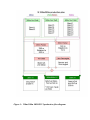
Download MODIS User Guide

Transcript
TABLE OF CONTENTS
Introduction
MOD13A3 VI
Product Description
File Format of
MODIS VI Products
MODIS VI
Product Sequence
MOD13A2 VI
Product Description
Algorithm
MOD13A1 VI
Product Description Description
Algorithm
Description
Scientific Data
Sets
Product Specific
Metadata
Global and Local
Metadata Attributes
Quality
Assurance
Scientific Data
Sets
Product Specific
Metadata
Global and Local
Metadata Attributes
QA
QA Science
Scientific Data
Sets
Product Specific
Metadata
Global and Local
Metadata Attributes
Quality
Assurance
Quality Assurance Metadata
QA
Metadata
QA
QA Science
Data Sets
QA Science
Data Sets
Metadata
Algorithm
Description
Related Web Sites
Appendix 1
Appendix 2
Data Sets
Introduction
One of the primary interests of the Earth Observing System (EOS) program is to
study the role of terrestrial vegetation in large-scale global processes with the goal of
understanding how the Earth functions as a system. This requires an understanding of
the global distribution of vegetation types as well as their biophysical and structural
properties and spatial/temporal variations. Vegetation Indices (VI) are robust,
empirical measures of vegetation activity at the land surface. They are designed to
enhance the vegetation reflected signal from measured spectral responses by
combining two (or more) different wavebands, often in the red (0.6-0.7 um) and NIR
wavelengths (0.7-1.1 um).
The MODIS vegetation index (VI) products provide consistent, spatial and
temporal comparisons of global vegetation conditions which can be used to monitor
the Earth's terrestrial photosynthetic vegetation activity in support of phenologic,
change detection, and biophysical interpretations. Gridded vegetation index maps
depicting spatial and temporal variations in vegetation activity are derived at 16-day
and monthly intervals for precise seasonal and interannual monitoring of the Earth�s
terrestrial vegetation.
Two vegetation index (VI) products are made globally robust and are produced
globally for land. One is the standard normalized difference vegetation index (NDVI),
which is referred to as the �continuity index� to the existing NOAA-AVHRR
derived NDVI. There is a 20-year NDVI global data set (1981 - 2000) from the
NOAA- AVHRR series, which could be extended by MODIS data to provide a long
term data record for use in operational monitoring studies. The second VI product is
the �enhanced� vegetation index (EVI) with improved sensitivity over high
biomass regions and improved vegetation monitoring capability through a decoupling of the canopy background signal and a reduction in atmosphere influe nces.
The two VIs complement each other in global vegetation studies and improve upon
the extraction of canopy biophysical parameters. A new compositing scheme that
reduces angular, sun-target-sensor variations, with an option to implement BRDF
models, is also utilized. The gridded vegetation index maps use MODIS surface
reflectances corrected for molecular scattering, ozone absorption, and aerosols, as
input to the VI equations. The gridded vegetation indices include quality assurance
(QA) flags with statistical data that indicate the quality of the VI product and input
data. The MODIS VI products are generated at multiple spatial resolutions every
sixteen days and each calendar month. Currently, the MODIS VIs are produced at
250m, 500m and 1km resolutions. A coarser, 0.25 degree, climate modeling grid
(CMG) version is forthcoming. For production purposes MODIS VIs are produced in
tile units that are approximately 1200km by 1200km in the integerized sinusoidal grid
projection. Only tiles containing land features are considered to help reduce
processing and disk space requirements. When mosaicked, all tiles cover the
terrestrial Earth and the global MODIS-VI can thus be generated each 16 days and
each calendar month.In this user guide we introduce the MODIS VI science algorithm,
file formats and data structure. This document serves as a reference manual for end
users when acquiring, accessing, or analyzing MODS VI products.
File Format of the MODIS VI Products
The MODIS production and science team chose the Hierarchical Data Format-Earth
Observing System (HDF-EOS) format, which is the standard archive format for EOS
Data Information System (EOSDIS) products. Each MODIS-VI file contains two
separate structures:
1. Scientific data sets (SDS) which are the actual data stored in array format (2-D, 3D and even 4-D),
2. Three sets of metadata:

structural metadata that describes the actual content of the file,

core metadata that describes the projection and grid name,
 archive metadata that describes various aspects of the file in terms of dates, times,
statistics about quality, useful to archive and search the product.
All MODIS VI products are in a grid structure, which are defined as projected, fixedarea size files. This was done for geolocation purposes and to facilitate the
correlation between the data and its actual location on Earth. Other formats used to
store MODIS data are the point structure and the swath structure. The use of
metadata is meant to enhance the self-describing characteristics of HDF files and is
useful to the end user, facilitating the archiving and searching of files. Parameter
Value Language (PVL) is used to write the various metadata to the product file as:
PARAMETER = VALUE
There are two types of metadata attributes: 1) global attributes which are general to all
MODIS products and 2) product specific attributes (PSA). From a practical
perspective, metadata will provide the user with general information about the file
contents, its characteristics and quality (through the QA PSA), which is used to decide
if the file is useful. The scientific data sets (SDS) could then be used for further
analyses and use of the product.
MODIS VI Product Sequence
There are 5 products in the MODIS VI sequence (Fig. 1)
1. MOD13A1: 16-day 250m or 500m VI
2. MOD13A2 16-day 1km VI
3. MOD13A3 monthly 1km VI
4. MOD13C1 16-day 25km VI
5. MOD13C2 monthly 25km VI
All products rely on the upstream surface reflectance (MOD09 series) product, which
is a daily level (L2) product. The VI algorithms ingest the level 2G surface
reflectances and temporally composite these to generate the 16-day, 250/500m or 1km
VI products. The 1 km VI product (MOD13A2), however, must first aggregate 250m
and 500m MODIS pixel sizes to 1km by way of the MODAGG algorithm (Fig.
1). The CMG product, MOD13C1, is generated through spatial averaging of the 1km
version, MOD13A2. Both monthly products, MOD13A3 and MOD13C2, are
temporal averages of their 16-day versions.
Figure 2 is an overview of the input and output data flow to the MODIS VI
products. The associated �Science Data Sets� (SDS) are included for each product
and vary from 6 for MOD13A1 to 17 for the MOD13C1 product.
Figure 1: Overview of the MODIS-VI product and their required inputs.
Figure 2: MODIS VI product series
MOD13A1 VI Product Description
This product is generated using the daily MODIS Level-2G (L2G) surface
reflectance, the L2G �pointer file�, the L2G �geo-angle file� and the L2G 1km
�state file� (Fig. 3). The output file contains a variable number of SDS�s
depending on the input resolution. When both NDVI and EVI are produced at either
250m or 500m the SDS content is as follows:

250m 16-day NDVI

250m 16-day EVI

250m 16-day NDVI Quality

250m 16-day EVI Quality

250m 16-day red reflectance

250m 16-day NIR reflectance

250m 16-day blue reflectance

250m 16-day MIR reflectance

250m 16-day average view zenith angle

250m 16-day average sun zenith angle

250m 16-day average relative azimuth angle
Similarly, at 500m the SDS names would be labeled 500m. Examples of the 16-day
250m MODIS products for the Southwest U.S.A. are included in this document:
 16-day 250m
NDVI
 16-day 250m
EVI.
Figure 3: 250m/500m MODIS VI production flow diagram.
Algorithm Description
The VI algorithm operates on a per-pixel basis and requires multiple
observations (days) to generate a composited VI. Due to sensor orbit overlap,
multiple observations may exist for one day and a maximum of four observations may
be collected. In theory, this can result in a maximum of 64 observations over a 16day cycle, however, due to the presence of clo uds and the actual sensor spatial
coverage, this number will range between 64 and 0 with decreasing observations from
higher to equatorial latitudes. The MOD13A1 algorithm separates all observations by
their orbits providing a means to further filter the input data.
Once all 16 days are collected, the MODIS VI algorithm applies a filter to the data
based on quality, cloud, and viewing geometry (Fig. 4). Cloud-contaminated pixels
and extreme off- nadir sensor views are considered lower quality. A cloud-free, nadir
view pixel with no residual atmospheric contamination represents the best quality
pixel. Only the higher quality, cloud-free, filtered data are retained for
compositing. Thus, the number of acceptable pixels over a 16-day compositing
period is typically less than 10 and often varies between 1 and 5, especially when one
considers a mean global cloud cover of 50 � 60%. The goal of the compositing
methodology is to extract a single value per pixel from all the retained filtered data,
which is representative of each pixel over the particular 16-day period. The VI
compositing algorithm utilized here uses a methodology with three separate
components (Fig. 5):
1. MVC: maximum value composite,
2. CV-MVC: constraint-view angle - maximum value composite,
3. BRDF-C: bidirectional reflectance distribution function composite.
The technique employed depends on the number and quality of observations. The
maximum value composite (MVC) is similar to that used in the AVHRR-NDVI
product, in which the pixel observation with the highest NDVI value is selected to
represent the entire period (16 days). Furthermore, the MOD13A1 algorithm will
choose the orbit observation with the highest NDVI if presented with multiple
observations for the same day (multiple orbits).
The CV-MVC, is an enhanced MVC technique, in which the �n� number of
observations (n being set to 3 at the moment) with the highest NDVI are compared
and the observation with the smallest view angle, i.e. closest to nadir view, is chosen
to represent the 16-day composite cycle. The BRDF scheme is a more elaborate
technique in which the algorithm utilizes all individual band observations, of
acceptable quality, to interpolate to their nadir-equivalent reflectance value from
which the VI is computed and produced. Currently the Walthal semi-empirical BRDF
model is being utilized for the BRDF compositing scheme.
Figure 4: Compositing algorithm data flow
Figure 5: MODIS-VI algorithm flow diagram
If five, good quality observations are available for a given pixel, then the
BRDF module is employed to derive nadir interpolated reflectance values from which
the VI�s are computed (Fig. 5). If there are less than five acceptable values then the
constrained view angle � maximum value composite (CV-MVC) module is
employed. Finally, the MVC technique serves as the backup, such that the pixel with
the highest VI value is assumed to be most representative over the 16-day period
marked by less than optimal data quality (Fig. 5).
All compositing
methodolgies result in spatial discontinuities, which are inevitable and result from the
fact that disparate days can always be chosen for adjacent pixels over the 16-day
period. Thus, adjacent �selected� pixels may originate from different days, with
different sun-pixel-sensor viewing geometries and different atmospheric and residual
cloud/smoke contamination. The BRDF method has the potential to achieve spatial
consistency through a standard nadir-view interpolation, however, at the moment the
BRDF scheme can only be employed with a minimum of five good quality
observations. Unfortunately, vegetation is most active during the rainy (and cloudy)
season, even in the deserts, and this greatly impedes the optimal selection of pixels in
any compositing methodoloy.
Scientific Data Sets
The 250m/500m VI product has the following characteristics (Table 1):
Table 1. Product MOD13A1: 16-day 250m/500m VI
Data field
DataField_1
Name
250m 16-day NDVI
Data type
INT16
DataField_2
DataField_3
DataField_4
DataField_5
DataField_6
DataField_7
DataField_8
DataField_9
DataField_10
DataField_11
250m 16-day EVI
250m 16-day NDVI Quality
250m 16-day EVI Quality
250m 16-day Red reflectance
250m 16-day NIR reflectance
250m 16-day blue reflectance
250m 16-day MIR reflectance
250m 16-day average view zenith angle
250m 16-day average sun zenith angle
250m 16-day average relative azimuth angle
INT16
UINT16
UINT16
INT16
INT16
INT16
INT16
INT16
INT16
INT16
Product Specific Metadata
A listing of the metadata fields used for QA evaluations of the MOD13A1 VI product
is included in Table 2.
Table 2. Metadata fields for QA evaluation of MOD13A1
I. Inventory Metadata fields for all VI products (searchable)
QAPERCENTINTERPOLATEDDATA
QAPERCENTMISSINGDATA
QAPERCENTOUTOFBOUNDSDATA
QAPERCENTCLOUDCOVER
QAPERCENTGOODQUALITY
QAPERCENTOTHERQUALITY
QAPERCENTNOTPRODUCEDCLOUD
QAPERCENTNOTPRODUCEDOTHER
II. Product specific metadata (searchable)
Product
Specific Metadata variable name (Best Quality)
MOD13A1 NDVI250M16DAYQCLASSPERCENTAGE
III. Archived Metadata (not searchable)
Product
Metadata variable name (Array of QA usefulness
histogram)
MOD13A1 QAPERCENTPOORQ250M16DAYNDVI
Global and Local Metadata Attributes
As in all MODIS products, the global metadata is written to the ouput file
during the generation process and could be used for searching the archive about the
product. A listing of all metadata found in the MODIS 13A1, VI product file is
included in Appendix 1.
Quality Assurance
The quality of the MOD13A1 product is indicated and assessed through the quality
assessment (QA) metadata objects and QA science data sets (SDS�s). The QA
metadata objects summarize tile�level (granule) quality with several single words
and numeric numbers, and thus are useful for data ordering and screening
processes. The QA SDS�s, on the other hand, document product quality on a pixelby-pixel basis and thus are useful for data analyses and application uses of the data.
QA Metadata
There are 18 QA metadata objects in the MOD13A1 product. These objects are listed
in Table 3 where they are characterized by the following five attributes:
1. Object name � Uniquely identifies and describes the content of each object.
2. Object type � Describes the object as either an ECS mandatory, MODLAND
mandatory, or VI product specific metadata object, and also as either text or numeric.
3. Group name � Identifies a metadata group to which the object belongs. All of the
QA metadata objects belong to either the InventoryMetadata or ArchiveMetadata
groups.
4. Description � Briefly describes the object, its valid value or format, and its sample
value(s).
5. Level � Describes whether the object value is given for each SDS or not.
The ECS QA metadata are mandatory to all of the EOS products (the first 10 objects
in Table 3), all of which are given for each SDS of the MOD13A1 product. The first
6 objects are called �QAFlags�, including AutomaticQualityFlag,
OperationalQualityFlag, ScienceQualityFlag, and their explanations. The
AutomaticQualityFlag object indicates a result of an automatic QA performed during
product generation and the following criteria are used to set its value:
1) Set to �Passed� if QAPercentMissingData � 5%,
2) Set to �Suspect� if QAPercentMissingData > 5% or < 50%,
3) Set to �Failed� if QAPercentMissingData � 50%,
where the �QAPercentMissingData� is also an ECS QA metadata object and is
described below. Explanation of the result of the AutomaticQualityFlag is given in
the AutomaticQualityFlagExplanation metadata object.
The OperationalQualityFlag indicates the results of manual, non-science QA
performed by processing facility personnel (DAAC or PI), i.e., if data are not
corrupted in the transfer, archival, and retrieval processes. The flag has the value of
�Not Being Investigated� if no non-science QA is performed. If the flag has the
value other than �Passed� or �Not Being Investigated�, explanation is given in
the OperationalQualityFlagExplanation object.
The ScienceQualityFlag indicates the results of manual, science-QA performed by
personnel at the VI Science Computing Facility (SCF). As for the
OperationalQualityFlag, the flag has the value of �Not Being Investigated� if
science QA is not performed. Explanation is given in the
ScienceQualityFlagExplanation object if the flag has the value other than �Passed�
or �Not Being Investigated�.
The last 4 ECS QA metadata objects are called �QAStats�. The QAStats indicate the percentages of
pixels in the tile of which values are either interpolated (QAPercentInterpolatedData), missing
(QAPercentMissingData), out of a valid range (QAPercentOutOfBoundData), or contaminated by
cloud cover (QAPercent CloudCover).
There are 4 MODLAND mandatory QA metadata objects, all of which are designed
to complement the ECS QA metadata objects. These indicate the percentages of
pixels in the tile that are either good quality (QAPercentGoodQuality), unreliable
quality (QAPercentOtherQuality), covered by cloud (QAPercentNotProducedCloud),
or not produced due to bad quality other than cloud cover
(QAPercentNotProducedOther). Different from the ECS QA metadata, only one set
of values are given per tile.
The last 4 QA metadata objects in Table 3 are designed specifically for the MODIS
VI product(s) (Product Specific Attributes, PSAs). Both the
NDVI500M16DAYQCLASSPERCENTAGE and
EVI500M16DAYQCLASSPERCENTAGE objects indicate the percentages of pixels
with good quality in the tile and, thus, should be equal to the QAPercentGoodQuality
value unless there is a significant difference between the NDVI a nd EVI performance
for the same tile.
The QAPERCENTPOORQ500M16DAYNDVI and
QAPERCENTPOORQ500M16DAYNDVI indicate, respectively, the percent
frequency distributions of the NDVI and EVI quality. Their values are computed as
sums of the NDVI and EVI usefulness indices (described in the QA Science Data Set
section) and, thus, include 16 integer numbers. The 16 numbers are ordered in the
descending qualities from left to right and a sum of 16 numbers is always equal to
100. The first numbers in the QAPERCENTPOORQ500M16DAYNDVI and
QAPERCENTPOORQ500M16DAYNDVI objects are equal to the values given in the
NDVI500M16DAYQCLASSPERCENTAGE and
EVI500M16DAYQCLASSPERCENTAGE objects, respectively.
Table 3. List of the QA Metadata Objects for the MOD13A1 Product
Object Name
AutomaticQuality
Flag
Object Type
Group Name
Description
ECS Mandatory InventoryMetadata in Result of an automatic quality
QAFlags, Text CoreMetadata.0
assessment performed during
product generation
Level
PerSDS,
Per-Tile
Valid value: �Passed�,
AutomaticQuality
�Suspect�, or �Failed�
ECS Mandatory InventoryMetadata in Explanation of the result of the
QAFlags, Text CoreMetadata.0
automatic quality assessment
PerSDS,
FlagExplanation
Valid value: Up to 255 characters Per-Tile
Sample value: �Run was
successful But no land data
found/processed�
OperationalQuality ECS Mandatory InventoryMetadata in Result of an manual, non-science PerQAFlags, Text CoreMetadata.0
quality assessment performed by SDS,
production facility personnel after
Flag
production
Per-Tile
Valid value: �Passed�,
�Suspect�, �Failed�,
�Inferred Passed�, �Inferred
Failed�, �Being Investigated�,
or �Not Being Investigated�
OperationalQuality ECS Mandatory InventoryMetadata in Explanation of the result of the
QAFlags, Text CoreMetadata.0
manual, non-science quality
assessment
FlagExplanation
PerSDS,
Per-Tile
Valid value: Up to 255 characters
ScienceQuality
Flag
Sample value:
ECS Mandatory InventoryMetadata in Result of an manual, science
PerQAFlags, Text CoreMetadata.0
quality assessment performed by SDS,
science computing facility
personnel after production
Per-Tile
Valid value: �Passed�,
�Suspect�, �Failed�,
�Inferred Passed�, �Inferred
Failed�, �Being Investigated�,
or �Not Being Investigated�
ScienceQuality
FlagExplanation
ECS Mandatory InventoryMetadata in Explanation of the result of the
QAFlags, Text CoreMetadata.0
manual, science quality
assessment
PerSDS,
Per-Tile
Valid value: Up to 255 characters
QAPercent
InterpolatedData
Sample value:
ECS Mandatory InventoryMetadata in Percentage of interpolated data in PerCoreMetadata.0
the tile
SDS,
QAStats,
Numeric
Valid value: 0~100
Sample value: 12
Per-Tile
QAPercent
ECS Mandatory InventoryMetadata in Percentage of missing data in the PerCoreMetadata.0
tile
SDS,
MissingData
QAStats,
Numeric
QAPercent
OutOfBoundData
Valid value: 0~100
Per-Tile
Sample value: 8
ECS Mandatory InventoryMetadata in Percentage of data in the tile of
CoreMetadata.0
which values are out of a valid
range
QAStats,
PerSDS,
Numeric
Per-Tile
Valid value: 0~100
QAPercent
CloudCover
QAPercent
GoodQuality
Sample value: 2
ECS Mandatory InventoryMetadata in Percentage of cloud covered data PerCoreMetadata.0
in the tile
SDS,
QAStats,
Numeric
Valid value: 0~100
Per-Tile
MODL AND
Mandatory,
Numeric
Sample value: 15
InventoryMetadata in Percentage of data produced with Per-Tile
CoreMetadata.0
good quality in the tile
Valid value: 0~100
QAPercent
OtherQuality
MODL AND
Mandatory,
Numeric
Sample value: �4�
InventoryMetadata in Percentage of data produced with Per-Tile
CoreMetadata.0
unreliable quality in the tile
Valid value: 0~100
QAPercent
MODL AND
Mandatory,
NotProducedCloud Numeric
Sample value: �56�
InventoryMetadata in Percentage of data produced but Per-Tile
CoreMetadata.0
contaminated with clouds in the
tile
Valid value: 0~100
QAPercent
MODL AND
Mandatory,
NotProducedOther Numeric
Sample value: �32�
InventoryMetadata in Percentage of data not produced Per-Tile
CoreMetadata.0
due to bad quality in the tile
Valid value: 0~100
Sample value: �8�
NDVI500M16DAY
QCLASS
VI Product
Specific,
Numeric
InventoryMetadata in Percentage of NDVI data
CoreMetadata.0
produced with good quality in the
tile
Per-Tile
Valid value: 0~100
PERCENTAGE
Sample value: �4�
EVI500M16DAY
QCLASS
VI Product
Specific,
Numeric
InventoryMetadata in Percentage of EVI data produced Per-Tile
CoreMetadata.0
with good quality in the tile
Valid value: 0~100
PERCENTAGE
QAPERCENT
POORQ
VI Product
Specific,
Numeric
Valid format: (N, N, N, N, N, N, N,
N, N, N, N, N, N, N, N, N), where
N = 0~100
500M16DAYNDVI
QAPERCENT
POORQ
Sample value: �4�
Archived Metadata in Summary statistics (percent
Per-Tile
ArchiveMetadata.0 frequency distribution) of the NDVI
usefulness index over the tile
VI Product
Specific,
Numeric
500M16DAYEVI
Sample value:
(4,0,0,0,44,6,18,15,5,0,0,0,0,0,0,8)
Archived Metadata in Summary statistics (percent
Per-Tile
ArchiveMetadata.0 frequency distribution) of the NDVI
usefulness index over the tile
Valid format: (N, N, N, N, N, N, N,
N, N, N, N, N, N, N, N, N), where
N = 0~100
Sample value:
(4,0,0,0,44,6,18,15,5,0,0,0,0,0,0,8)
QA Science Data Sets
The MOD13A1 product include 2 QA science data sets (SDS�s) (the 250/500m 16
days NDVI Quality SDS for the NDVI and the 250/500m 16 days EVI Quality SDS
for the EVI) which are also called the per-pixel QA. Their dimensions (the numbers
of samples and lines) are the same as those of the VI SDS�s and each pixel consists
of 10 bit- fields (a total of 16 bits). Their contents are explained in Fig. 6. Table 4
lists the names of the bit- fields (parameter names), the number of bits assigned for the
bit- field, and the bit combinations and their corresponding descriptions. As seen in
Table 4, the per-pixel QA bits are designed to document conditions under which each
pixel was acquired and processed. The NDVI and EVI per-pixel QA bits have an
identical format.
Table 4. Descriptions of the VI Quality Assessment Science Data Sets (QA SDS)
Bit No. Parameter Name
0-1
2-5
Bit
Description
Comb.
VI Quality
00
VI produced with good quality
(MODL AND
01
VI produced but with unreliable quality and thus examination of
Mandatory QA Bits)
other QA bits recommended
10
VI produced but contaminated with clouds
11
VI not produced due to bad quality
VI Usefulness Index 0000 Perfect quality (equal to VI quality = 00: VI produced with good
quality)
0001 High quality
0010 Good quality
0011 Acceptable quality
0100 Fair quality
0101 Intermediate quality
0110 Below intermediate quality
0111
1000
1001
1010
1011
1100
1101
1110
1111
6-7
Aerosol Quantity
8
Atmosphere
9
Adjacency
Correction
Atmosphere
10
BRDF Correction
Mi xed Clouds
11-12
Land/Water Mask
Average quality
Below average quality
Questionable quality
Above marginal quality
Marginal quality
Low quality
No atmospheric correction performed
Quality too low to be useful
Not useful for other reasons
00
01
10
11
0
1
(equal to VI quality = 11: VI not produced due to bad quality)
Climatology used for atmospheric correction
Low
Intermediate
High
(No) No adjacency correction performed
(Yes) Adjacency correction performed
0
1
(No) No atmosphere-surface BRDF coupled correction performed
(Yes) Atmosphere-surface BRDF coupled correction performed
0
1
00
(No) No mixed clouds
(Yes) Possible existence of mixed clouds
Ocean/inland water
01

Shallow ocean

Moderate and continental ocean

Deep ocean

Deep inland water
Coastal region

10
13
Snow/Ice
14
Shadow
15
Compositing
Method
11
0
1
0
1
0
1
Ocean coastlines and lake shorelines

Shallow inland water
Wetland

Ephemeral water
Land
(No) No snow/ice
(Yes) Possible existence of snow/ice
(No) No shadow
(Yes) Possible existence of shadow
BRDF composite method used for compositing
Constraint view angle MVC (C V-MVC) method used for
compositing
The first two bits are used for the MODLAND mandatory per-pixel QA bits that
summarize the VI quality of the corresponding pixel locations. Percentages of sums
of its four possible values (bit combinations) over a tile will give the MODLAND
mandatory QA metadata object values (Table 5).
Table 5. Relationship between the MODLAND Mandatory per-pixel QA Bits and
QA Metadata Objects
00: VI
01: VI
10: VI
11: VI
VI Quality Bit Combination
produced, good quality
produced, unreliable quality
produced, contaminated with cloud
not produced due to bad quality other than cloud
Corresponding QA Metadata Object
QAPercentGoodQuality
QAPercentOtherQuality
QAPercentNotProducedCloud
QAPercentNotProducedOther
The 2nd QA bit- field is called the VI usefulness index. The usefulness index is a
higher resolution quality indicator than the MODLAND mandatory QA bits (16 levels)
and its value for a pixel is determined from several conditions, including 1) aerosol
quantity, 2) atmospheric correction conditions, 3) cloud cover, 4) shadow, and 5) suntarget- viewing geometry (Table 6). As shown in Table 6, there is a specific score that
is assigned to each condition and a sum of all the scores gives a usefulness index
value for the pixel. An index value of 0000 is corresponding to the highest quality,
while the lowest quality is equal to a value of 1100 (i.e., 13 levels). The three largest
values are reserved for three specific conditions which are shown in Table 4. There
are relationships between the VI usefulness index and the MODLAND mandatory QA
bits. Pixels with the index value of 0000 and 1111 always have the MODLAND QA
bit values of 00 and 11, respectively.
Table 6. VI Usefulness Index Scaling Method for the MOD13A1 Product
Parameter Name
Aerosol Quantity
Atmosphere
Adjacency Correction
Atmosphere
BRDF Correction
Mi xed Clouds
Shadow
View zenith angle (q v)
Sun zenith angle (q s)
Condition
If aerosol climatology was used for atmospheric correction
(00)
If aerosol quantity was high (11)
If no adjacency correction was performed (0)
Score
2
3
1
If no atmosphere-surface BRDF coupled correction was
performed (0)
2
If there possibly existed mixed clouds (1)
If there possibly existed shadow (1)
If q v > 40 o
If q s > 60 o
3
2
1
1
The next three QA bit- fields document atmospheric correction scenarios of
each pixel. The bits 6-7 are used to indicate aerosol quantity, and the bits 8 and 9
indicate whether an adjacency correction and atmosphere-surface BRDF coupled
correction, respectively, are applied or not.
The bit 10 indicates a possible existence of mixed clouds. As the original spatial
resolutions of the red and NIR bands are 250 m, these two bands were spatially
aggregated to a 500 m resolution before the computations of VIs. The mixed cloud
QA bit is flagged if any of the 250 m resolution pixels that were used for the
aggregations were contaminated with cloud.
The bits 10-11 are used for the land/water mask. The input land/water mask to the
MOD13A1 VI product has 7 land/water classes. These 7 classes are lumped to 4
classes upon the generations of the VI products, including the ocean/inland water,
coastal region, wetland, and land classes. The VIs are not computed for pixels only
over the ocean/inland water class.
The bits 13 and 14 indicate possible existences of snow/ice and shadow, respectively.
The last QA bit field indicates a compositing method used for each pixel as the
MODIS VI compositing algorithm utilizes two compositing methods (the BRDF
compositing and CV-MVC methods) interchangeably from pixel to pixel. Currently,
the BRDF compositing algorithm has been deactivated and, thus, this QA bit is
always set to 1.
Figure 6: MODIS � VI Quality Assurance SDS bit map.
MOD13A2 VI Product Description
This product is generated using the output of the daily, MODIS surface
reflectance aggregation algorithm (MODAGG). The output file contains 11 scientific
data sets (SDS�s):

1 km 16-day NDVI

1 km 16-day EVI

1 km 16-day NDVI Quality

1 km 16-day EVI Quality

1 km 16-day red reflectance

1 km 16-day NIR reflectance

1 km 16-day blue reflectance

1 km 16-day MIR reflectance

1 km 16-day average view zenith angle

1 km 16-day average sun zenith angle

1 km 16-day average relative azimuth angle
Examples of the 16-day 1 km MODIS products on a global scale are included in this
document:
 16-day
1km NDVI
 16-day
1km EVI
 16-day
1km QA
Algorithm Description
The VI algorithm, as in MOD13A1, operates on a per-pixel basis and requires
multiple observations (days) to generate a composited VI. Due to sensor orbit overlap,
multiple observations may exist for one day, hence the aggregation algorithm
(MODAGG) precedes the VI algorithm. MODAGG will ingest all the daily projected
(tile) surface reflectance data and generate a maximum of four observations based on
quality, cloud cover, and viewing geometry. In theory, this can result in a maximum
of 64 observations over a 16-day cycle, however, due to the presence of clouds and
the actual sensor spatial coverage, this number will range between 64 and 0 with
decreasing observations from higher to equatorial latitudes.
Once all 16 days are collected, the MODIS VI algorithm applies a filter to the data
based on quality, cloud, and viewing geometry (Fig. 4). Cloud-contaminated pixels
and extreme off- nadir sensor views are considered lower quality. A cloud-free, nadir
view pixel with no residual atmospheric contamination represents the best quality
pixel. Only the higher quality, cloud-free, filtered data are retained for
compositing. Thus, the number of acceptable pixels over a 16-day compositing
period is typically less than 10 and often varies between 1 and 5, especially when one
considers a mean global cloud cover of 50 � 60%. The goal of the compositing
methodology is to extract a single value per pixel from all the retained filtered data,
which is representative of each pixel over the particular 16-day period. The VI
compositing algorithm utilized here uses a methodology with three separate
components (Fig. 5):
1. MVC: maximum value composite,
2. CV-MVC: constraint-view angle - maximum value composite,
3. BRDF-C: bidirectional reflectance distribution function composite.
The technique employed depends on the number and quality of observations. The
maximum value composite (MVC) is similar to that used in the AVHRR-NDVI
product, in which the pixel observation with the highest NDVI value is selected to
represent the entire period (16 days). Furthermore, the MOD13A1 algorithm will
choose the orbit observation with the highest NDVI if presented with multiple
observations for the same day (multiple orbits).
The CV-MVC, is an enhanced MVC technique, in which the �n� number of
observations (n being set to 3 at the moment) with the highest NDVI are compared
and the observation with the smallest view angle, i.e. closest to nadir view, is chosen
to represent the 16-day composite cycle. The BRDF scheme is a more elaborate
technique in which the algorithm utilizes all individual band observations, of
acceptable quality, to interpolate to their nadir-equivalent reflectance value from
which the VI is computed and produced. Currently the Walthal semi-empirical BRDF
model is being utilized for the BRDF compositing scheme.
If five, good quality observations are available for a given pixel, then the
BRDF module is employed to derive nadir interpolated reflectance values from which
the VI�s are computed (Fig. 5). If there are less than five acceptable values then the
constrained view angle � maximum value composite (CV-MVC) module is
employed. Finally, the MVC technique serves as the backup, such that the pixel with
the highest VI value is assumed to be most representative over the 16-day period
marked by less than optimal data quality (Fig. 5) All compositing methodolgies
result in spatial discontinuities, which are inevitable and result from the fact that
disparate days can always be chosen for adjacent pixels over the 16-day period. Thus,
adjacent �selected� pixels may originate from different days, with different sunpixel-sensor viewing geometries and different atmospheric and residual cloud/smoke
contamination. The BRDF method has the potential to achieve spatial consistency
through a standard nadir-view interpolation, however, at the moment the BRDF
scheme can only be employed with a minimum of five good quality
observations. Unfortunately, vegetation is most active during the rainy (and cloudy)
season, even in the deserts, and this greatly impedes the optimal selection of pixels in
any compositing methodoloy.
Scientific Data Sets
The 1km VI product has the following Science Data Sets (Table 7):
Table 7. Product MOD13A2: 16-day 1 km VI
Data field
DataField_1
DataField_2
DataField_3
DataField_4
DataField_5
DataField_6
DataField_7
DataField_8
DataField_9
DataField_10
DataField_11
Name
1 km 16-day NDVI
1 km 16-day EVI
1 km 16-day NDVI Quality
1 km 16-day EVI Quality
1 km 16-day red reflectance
1 km 16-day NIR reflectance
1 km 16-day blue reflectance
1 km 16-day MIR reflectance
1 km 16-day average view zenith angle
1 km 16-day average sun zenith angle
1 km 16-day average relative azimuth angle
Data type
INT16
INT16
UINT16
UINT16
INT16
INT16
INT16
INT16
INT16
INT16
INT16
Product Specific Metadata
A listing of the metadata fields used for QA evaluations of the MOD13A2 VI product
is included in Table 8.
Table 8. Metadata fields for QA evaluation of MOD13A2
I. Inventory Metadata fields for all VI products (searchable)
QAPERCENTINTERPOLATEDDATA
QAPERCENTMISSINGDATA
QAPERCENTOUTOFBOUNDSDATA
QAPERCENTCLOUDCOVER
QAPERCENTGOODQUALITY
QAPERCENTOTHERQUALITY
QAPERCENTNOTPRODUCEDCLOUD
QAPERCENTNOTPRODUCEDOTHER
II. Product specific metadata (searchable)
Product
Specific Metadata variable name (Best Quality)
MOD13A2 NDVI1KM16DAYQCLASSPERCENTAGE
MOD13A2 EVI1KM16DAYQCLASSPERCENTAGE
III. Archived Metadata (not searchable)
Product
Metadata variable name (Array of QA usefulness
histogram)
MOD13A2 QAPERCENTPOORQ1KM16DAYNDVI
MOD13A2 QAPERCENTPOORQ1KM16DAYEVI
Global and Local Metadata Attributes
As in all MODIS products, the global metadata is written to the ouput file
during the generation process and could be used for searching the archive about the
product. A listing of all metadata found in the MODIS 13A2, VI product file is
included in Appendix 2.
Quality Assurance
In principal, the QA metadata objects and QA SDS�s of the MOD13A2 product are
the same as those of the MOD13A1 product. In this section, we only describe the
differences of the MOD13A2 product QA from the MOD13A1 product QA.
QA Metadata
As the spatial resolution of the MOD13A2 product differs from that of the MOD13A1
product, the 4 VI PSA object names differ correspondingly. Table 9 lists the
correspondences between these object names.
Table 9. Correspondence of the VI PSA QA Metadata Object Names between the
MOD13A2 and MOD13A1 Products
Object Name in the MOD13A2
NDVI1KM16DAYQCLASSPERCENTAGE
EVI1KM16DAYQCL ASSPERCENTAGE
QAPERCENTPOORQ1KM16DAYNDVI
QAPERCENTPOORQ1KM16DAYEVI
QA Science Data Sets
Object Name in the MOD13A1
NDVI500M16DAYQCLASSPERCENTAGE
EVI500M16DAYQCLASSPERCENTAGE
QAPERCENTPOORQ500M16DAYND VI
QAPERCENTPOORQ500M16DAYEVI
As the atmospheric adjacency effects are no longer of importance for a 1 km distance,
the QA bit field for the adjacency atmospheric correction (the bit 8) is used instead to
indicate a possible existence of adjacency cloud in the MOD13A2 QA SDS�s (Table
10). Accordingly, the condition of the atmospheric adjacency correction is not
considered in the VI usefulness index computation (Table 11).
Table 10. Description of the 8th QA Bit for the MOD13A2 Product
Bit No. Parameter Name
8
Adjacency Cloud
Bit
Description
Comb.
0
(No) No adjacency cloud detected
1
(Yes) Possible existence of adjacency cloud
Table 11. VI Usefulness Index Scaling Method for the MOD13A2 Product
Parameter Name
Aerosol Quantity
Atmosphere
Condition
If aerosol climatology was used for atmospheric correction
(00)
If aerosol quantity was high (11)
If no atmosphere-surface BRDF coupled correction was
performed (0)
BRDF Correction
Mi xed Clouds
Shadow
If there possibly existed mixed clouds (1)
If there possibly existed shadow (1)
View zenith angle (q v)
Sun zenith angle (q s)
If q v > 40 o
If q s > 60 o
Score
2
3
2
3
2
1
1
MOD13A3 Product Description
This product is generated using the 1km 16 day MODIS VI output. The output file
contains 11 SDS�s:

1 km monthly NDVI

1 km monthly EVI

1 km monthly NDVI Quality

1 km monthly EVI Quality

1 km monthly red reflectance

1 km monthly NIR reflectance

1 km monthly blue reflectance

1 km monthly MIR reflectance

1 km monthly average view zenith angle

1 km monthly average sun zenith angle

1 km monthly average relative azimuth angle
Algorithm Description
This algorithm operates (Fig. 7) on a per-pixel basis and requires all 16-day VI
products which overlap within a calendar month. Once all 16-day composites are
collected, a weighing factor based on the degree of temporal overlap is applied to
each input. In assigning the pixel QA, a worst case scenario is used, whereby the
pixel with the lowest quality determines the final pixel QA.
Figure 7: Monthly MODIS VI flow diagram
Scientific Data Sets
The 1km monthly VI product has the following SDS�s (Table 12):
Table 12. Product MOD13A3: month1y 1km VI
Data field
DataField_1
DataField_2
DataField_3
DataField_4
DataField_5
DataField_6
DataField_7
DataField_8
DataField_9
DataField_10
Name
1 km monthly NDVI
1 km monthly EVI
1 km monthly NDVI Quality
1 km monthly EVI Quality
1 km monthly red reflectance
1 km monthly NIR reflectance
1 km monthly blue reflectance
1 km monthly MIR reflectance
1 km monthly average view zenith angle
1 km monthly average sun zenith angle
Data type
INT16
INT16
UINT16
UINT16
INT16
INT16
INT16
INT16
INT16
INT16
DataField_11
1 km monthly average relative azimuth angle
INT16
Product Specific Metadata
A listing of the metadata fields used for QA evaluations of the MOD13A3 VI product
is included in Table 13.
Table 13. Metadata fields for QA evaluation of MOD13A3
I. Inventory Metadata fields for all VI products (searchable)
QAPERCENTINTERPOLATEDDATA
QAPERCENTMISSINGDATA
QAPERCENTOUTOFBOUNDSDATA
QAPERCENTCLOUDCOVER
QAPERCENTGOODQUALITY
QAPERCENTOTHERQUALITY
QAPERCENTNOTPRODUCEDCLOUD
QAPERCENTNOTPRODUCEDOTHER
II. Product specific metadata (searchable)
Product
Specific Metadata variable name (Best Quality)
MOD13A3 NDVI1KMMONTHQCLASSPERCENTAGE
MOD13A3 EVI1KMMONTHQCLASSPERCENTAGE
III. Archived Metadata (not searchable)
Product
Metadata variable name (Array of QA usefulness
histogram)
MOD13A3 QAPERCENTPOORQ1KMMONTHNDVI
MOD13A3 QAPERCENTPOORQ1KMMONTHEVI
Global and Local Metadata Attributes
Almost the same as in MOD13A2 (1km 16-day VI), please refer to the MOD13A2
description.
Quality Assurance
As in the MOD13A1 and MOD13A2 products, each output pixel has two QA SDS�s
(NDVI and EVI quality). Their bit description is described in Fig. 6. As was done for
the MOD13A2 product, we only describe the differences of the MOD13A3 product
QA from the MOD13A1 product QA.
QA Metadata
As both the spatial and temporal resolutions of the MOD13A3 product differ from
those of the MOD13A1 product, the 4 VI PSA object names differ
correspondingly. Table 14 lists the correspondences between these object names.
Table 14. Correspondence of the VI PSA QA Metadata Object Names between the
MOD13A3 and MOD13A1 Products
Object Name in the MOD13A2
NDVI1KMMONTHQCLASSPERCENTAGE
EVI1KMMONTHQCL ASSPERCENTAGE
QAPERCENTPOORQ1KMMONTHNDVI
QAPERCENTPOORQ1KMMONTHEVI
Object Name in the MOD13A1
NDVI500M16DAYQCLASSPERCENTAGE
EVI500M16DAYQCLASSPERCENTAGE
QAPERCENTPOORQ500M16DAYND VI
QAPERCENTPOORQ500M16DAYEVI
QA Science Data Sets
As for the MOD13A2 product, the QA bit field for the adjacency atmospheric
correction (the 8th bit) is used to indicate a possible existence of adjacency cloud in
the MOD13A3 QA SDSs (Table 15).
The other difference is that the 14th bit is used to indicate whether mixed compositing
methods were used, as the MOD13A3 product is derived as a weighting average of 2
� 3 MOD13A2 products of which 16 days periods overlap with a month (Table
15). Currently, the BRDF compositing algorithm has been deactivated and, thus, the
14th and 15th QA bit are always set to 0 and 1, respectively.
Table 15. Description of Two QA Bit-fields for the MOD13A3 VI Product
Bit No. Parameter Name
8
Adjacency Cloud
14
Mi xed Compositing
Methods
Bit
Comb.
0
1
0
1
Description
(No) No adjacency cloud detected
(Yes) Possible existence of adjacency cloud
(No) Mixed compositing method not used
(Yes) Mi xed compositing method used
Related Web Sites
MODIS VI Web site: http://gaea.fcr.arizona.edu
Terra Website: http://terra.nasa.gov
MODIS Project: http://modarch.gsfc.nasa.gov/MODIS/MODIS.html
MODIS Land Discipline: http://modis- land.gsfc.nasa.gov/
EOSDIS: http://spsosun.gsfc.nasa.gov/ESDIShome.html
HDF: http://hdf.ncsa.uiuc.edu
HDF-EOS:http://hdfeos.gsfc.nasa.gov/hdfeos/workshop.html
ECS: http://observer.gsfc.nasa.gov/
EVI (left) and NDVI (right) Color Scale Legend
Figure 8. Example of a 16-day MODIS 250m EVI, ISIN Grid. This Southwest U.S.A. image
shows the Imperial Valley agriculture region, the U.S. � Mexico International border, the Salton
Sea, Colorado River and Gila River. Color scale legend.
Figure 9. Example of a 16-day MODIS 250m NDVI, ISIN Grid. This Southwest U.S.A. image
shows the Imperial Valley agriculture region, the U.S. � Mexico International border, the Salton
Sea, Colorado River and Gila River. Color scale legend.
Figure 10. Example of a global 16-day MODIS 1km EVI for period 177-192 (2000).
Color scale legend.
Figure 11. Example of a global 16-day MODIS 1km NDVI for period 177-192 (2000).
Color scale legend.
Figure 12.
Example of a global 16-day MODIS 1km EVI QA map for period 177-192
(2000).
Color scale legend.
QA legend.
APPENDIX 1
MOD13A1 Global and Local Metadata
Attributes
Global attributes: 4
HDFEOSVersion: HDFEOS_V2.4s NDVI
StructMetadata.0: GROUP=Sw athStructure
END_GROUP=Sw athStructure
GROUP=GridStructure
GROUP=GRID_1
GridName="MODIS_ Grid_16DA Y_500m_ VI"
XDim=2400
YDim=2400
UpperLeftPointMtrs=(-6671703.118599,6671703.118599)
LowerRightMtrs=(-5559752.598833,5559752.598833)
Projection=GCTP_ISINUS
ProjParams=(6371007.181000,0,0,0,0,0,0,0,21600,0,1,0,0)
SphereCode=-1
GROUP=Dimension
END_ GROUP=Dimension
GROUP=DataField
OBJECT=DataField_1
DataField Name=" 500m 16 days NDVI"
DataType=DFNT_INT16
DimList=(" YDim"," XDim")
END_ OBJECT=DataField_1
OBJECT=DataField_2
DataField Name=" 500m 16 days EVI"
DataType=DFNT_INT16
DimList=(" YDim"," XDim")
END_ OBJECT=DataField_2
OBJECT=DataField_3
DataField Name=" 500m 16 days NDVI Quality"
DataType=DFNT_ UINT16
DimList=(" YDim"," XDim")
END_ OBJECT=DataFie ld_3
OBJECT=DataField_4
DataField Name=" 500m 16 days EVI Quality"
DataType=DFNT_ UINT16
DimList=(" YDim"," XDim")
END_ OBJECT=DataField_4
OBJECT=DataField_5
DataField Name=" 500m 16 days RED reflectance"
DataType=DFNT_INT16
DimList=(" YDim"," XDim")
END_ OBJECT=DataField_5
OBJECT=DataField_6
DataField Name=" 500m 16 days NIR reflectance"
DataType=DFNT_INT16
DimList=(" YDim"," XDim")
END_ OBJECT=DataField_6
OBJECT=DataField_7
DataField Name=" 500m 16 days BLUE reflectance"
DataType=DFNT_INT16
DimList=(" YDim"," XDim")
END_ OBJECT=DataField_7
OBJECT=DataField_8
DataField Name=" 500m 16 days MIR reflectance"
DataType=DFNT_INT16
DimList=(" YDim"," XDim")
END_ OBJECT=DataField_8
OBJECT=DataField_9
DataField Name=" 500m 16 days average view zenith angle"
DataType=DFNT_INT16
DimList=(" YDim"," XDim")
END_ OBJECT=DataField_9
OBJECT=DataField_10
DataField Name=" 500m 16 days average sun zenith angle"
DataType=DFNT_INT16
DimList=(" YDim"," XDim")
END_ OBJECT=DataField_10
OBJECT=DataField_11
DataField Name=" 500m 16 days average relative azimuth
angle"
DataType=DFNT_INT16
DimList=(" YDim"," XDim")
END_ OBJECT=DataField_11
END_ GROUP=DataField
GROUP=MergedFields
END_ GROUP=MergedFields
END_ GROUP=GRID_1
END_GROUP=GridStructure
GROUP=PointStructure
END_GROUP=PointStructure
END
CoreMetadata.0:
GROUP
GROUPTYPE
GROUP
OBJECT
NUM_ VA L
VA LUE
END_OBJECT
OBJECT
NUM_ VA L
VA LUE
END_OBJECT
OBJECT
NUM_ VA L
VA LUE
END_OBJECT
OBJECT
NUM_ VA L
VA LUE
END_OBJECT
OBJECT
NUM_ VA L
VA LUE
END_OBJECT
END_ GROUP
GROUP
= INVENTORYM ETADATA
= MASTERGROUP
= ECSDATA GRANULE
= LOCA LGRA NULEID
=1
= "MOD13A 1.A2000129.h12v03.002.2000202212444.hdf"
= LOCA LGRA NULEID
= PRODUCTIONDATETIM E
=1
= " 2000-07-21T04:24:44.000Z"
= PRODUCTIONDATETIM E
= DA YNIGHTFLA G
=1
= " Both"
= DA YNIGHTFLA G
= REPROCESSINGA CTUAL
=1
= "processed once"
= REPROCESSINGA CTUA L
= REPROCESSINGPLANNED
=1
= "further update anticipated"
= REPROCESSINGPLANNED
= ECSDATA GRANULE
= M EASUREDPARAM ETER
OBJECT
CLASS
GROUP
CLASS
OBJECT
NUM_ VA L
= M EASUREDPARAM ETERCONTAINER
= "1"
= QAFLA GS
= " 1"
= AUTOMATICQUA LITYFLA GEXPLA NATION
=1
CLASS
= "1"
VA LUE
= "Product will be evaluated after launch"
END_OBJECT
OBJECT
NUM_ VA L
= AUTOMATICQUA LITYFLA GEXPLA NATION
= AUTOMATICQUA LITYFLA G
=1
CLASS
= "1"
VA LUE
= "Suspect"
END_OBJECT
END_ GROUP
GROUP
CLASS
OBJECT
NUM_ VA L
= AUTOMATICQUA LITYFLA G
= QA FLA GS
= QASTATS
= " 1"
= QAPERCENTMISSINGDATA
=1
CLASS
= "1"
VA LUE
=0
END_OBJECT
OBJECT
NUM_ VA L
= QAPERCENTM ISSINGDATA
= QAPERCENTOUTOFBOUNDSDATA
=1
CLASS
= "1"
VA LUE
=0
END_OBJECT
= QAPERCENTOUTOFBOUNDSDATA
OBJECT
= QAPERCENTCLOUDCOVER
NUM_ VA L
=1
CLASS
= "1"
VA LUE
=1
END_OBJECT
OBJECT
= QAPERCENTCLOUDCOVER
= QAPERCENTINTERPOLATEDDATA
NUM_ VA L
=1
CLASS
= "1"
VA LUE
=0
END_OBJECT
= QAPERCENTINTERPOLATEDDATA
END_ GROUP
OBJECT
CLASS
NUM_ VA L
VA LUE
= QA STATS
= PARAM ETERNAM E
= " 1"
=1
= "500m 16 days NDVI"
END_ OBJECT
END_OBJECT
OBJECT
CLASS
GROUP
CLASS
OBJECT
NUM_ VA L
= PARAM ETERNAME
= M EASUREDPA RAM ETERCONTAINER
= M EASUREDPARAM ETERCONTAINER
= "2"
= QAFLA GS
= " 2"
= AUTOMATICQUA LITYFLA GEXPLA NATION
=1
CLASS
= "2"
VA LUE
= "Product will be evaluated after launch"
END_OBJECT
OBJECT
= AUTOMATICQUA LITYFLA GEXPLA NATION
= AUTOMATICQUA LITYFLA G
NUM_ VA L
=1
CLASS
= "2"
VA LUE
= "Suspect"
END_OBJECT
END_ GROUP
GROUP
CLASS
OBJECT
NUM_ VA L
= AUTOMATICQUA LITYFLA G
= QA FLA GS
= QASTATS
= " 2"
= QAPERCENTMISSINGDATA
=1
CLASS
= "2"
VA LUE
=1
END_OBJECT
OBJECT
NUM_ VA L
= QAPERCENTM ISSINGDATA
= QAPERCENTOUTOFBOUNDSDATA
=1
CLASS
= "2"
VA LUE
=0
END_OBJECT
OBJECT
NUM_ VA L
= QAPERCENTOUTOFBOUNDSDATA
= QAPERCENTCLOUDCOVER
=1
CLASS
= "2"
VA LUE
=1
END_OBJECT
OBJECT
NUM_ VA L
= QAPERCENTCLOUDCOVER
= QAPERCENTINTERPOLATEDDATA
=1
CLASS
= "2"
VA LUE
=0
END_OBJECT
= QAPERCENTINTERPOLATEDDATA
END_ GROUP
OBJECT
CLASS
NUM_ VA L
VA LUE
= QA STATS
= PARAM ETERNAM E
= " 2"
=1
= "500m 16 days EVI"
END_ OBJECT
END_OBJECT
OBJECT
CLASS
GROUP
CLASS
OBJECT
NUM_ VA L
= PARAM ETERNAME
= M EASUREDPA RAM ETERCONTAINER
= M EASUREDPARAM ETERCONTAINER
= "3"
= QAFLA GS
= " 3"
= AUTOMATICQUA LITYFLA GEXPLA NATION
=1
CLASS
= "3"
VA LUE
= "Product will be evaluated after launch"
END_OBJECT
OBJECT
NUM_ VA L
= AUTOMATICQUA LITYFLA GEXPLA NATION
= AUTOMATICQUA LITYFLA G
=1
CLASS
= "3"
VA LUE
= "Suspect"
END_OBJECT
END_ GROUP
GROUP
CLASS
OBJECT
NUM_ VA L
CLASS
= AUTOMATICQUA LITYFLA G
= QA FLA GS
= QASTATS
= " 3"
= QAPERCENTMISSINGDATA
=1
= "3"
VA LUE
=0
END_OBJECT
OBJECT
= QAPERCENTM ISSINGDATA
= QAPERCENTOUTOFBOUNDSDATA
NUM_ VA L
=1
CLASS
= "3"
VA LUE
=0
END_OBJECT
OBJECT
= QAPERCENTOUTOFBOUNDSDATA
= QAPERCENTCLOUDCOVER
NUM_ VA L
=1
CLASS
= "3"
VA LUE
=1
END_OBJECT
OBJECT
= QAPERCENTCLOUDCOVER
= QAPERCENTINTERPOLATEDDATA
NUM_ VA L
=1
CLASS
= "3"
VA LUE
=0
END_OBJECT
= QAPERCENTINTERPOLATEDDATA
END_ GROUP
OBJECT
CLASS
NUM_ VA L
VA LUE
= QA STATS
= PARAM ETERNAM E
= " 3"
=1
= "500m 16 days NDVI Quality"
END_ OBJECT
END_OBJECT
OBJECT
CLASS
GROUP
= PARAM ETERNAME
= M EASUREDPA RAM ETERCONTAINER
= M EASUREDPARAM ETERCONTAINER
= "4"
= QAFLA GS
CLASS
OBJECT
NUM_ VA L
= " 4"
= AUTOMATICQUA LITYFLA GEXPLA NATION
=1
CLASS
= "4"
VA LUE
= "Product will be evaluated after launch"
END_OBJECT
OBJECT
NUM_ VA L
= AUTOMATICQUA LITYFLA GEXPLA NATION
= AUTOMATICQUA LITYFLA G
=1
CLASS
= "4"
VA LUE
= "Suspect"
END_OBJECT
END_ GROUP
GROUP
CLASS
OBJECT
NUM_ VA L
= AUTOMATICQUA LITYFLA G
= QA FLA GS
= QASTATS
= " 4"
= QAPERCENTMISSINGDATA
=1
CLASS
= "4"
VA LUE
=1
END_OBJECT
OBJECT
NUM_ VA L
= QAPERCENTM ISSINGDATA
= QAPERCENTOUTOFBOUNDSDATA
=1
CLASS
= "4"
VA LUE
=0
END_OBJECT
OBJECT
NUM_ VA L
CLASS
= QAPERCENTOUTOFBOUNDSDATA
= QAPERCENTCLOUDCOVER
=1
= "4"
VA LUE
=1
END_OBJECT
OBJECT
= QAPERCENTCLOUDCOVER
= QAPERCENTINTERPOLATEDDATA
NUM_ VA L
=1
CLASS
= "4"
VA LUE
=0
END_OBJECT
= QAPERCENTINTERPOLATEDDATA
END_ GROUP
OBJECT
CLASS
NUM_ VA L
VA LUE
= QA STATS
= PARAM ETERNAM E
= " 4"
=1
= "500m 16 days EVI Quality"
END_ OBJECT
END_OBJECT
OBJECT
CLASS
GROUP
CLASS
OBJECT
NUM_ VA L
= PARAM ETERNAME
= M EASUREDPA RAM ETERCONTAINER
= M EASUREDPARAM ETERCONTAINER
= "5"
= QAFLA GS
= " 5"
= AUTOMATICQUA LITYFLA GEXPLA NATION
=1
CLASS
= "5"
VA LUE
= "Product will be evaluated after launch"
END_OBJECT
OBJECT
NUM_ VA L
= AUTOMATICQUA LITYFLA GEXPLA NATION
= AUTOMATICQUA LITYFLA G
=1
CLASS
= "5"
VA LUE
= "Suspect"
END_OBJECT
END_ GROUP
GROUP
CLASS
OBJECT
NUM_ VA L
= AUTOMATICQUA LITYFLA G
= QA FLA GS
= QASTATS
= " 5"
= QAPERCENTMISSINGDATA
=1
CLASS
= "5"
VA LUE
=0
END_OBJECT
OBJECT
NUM_ VA L
= QAPERCENTM ISSINGDATA
= QAPERCENTOUTOFBOUNDSDATA
=1
CLASS
= "5"
VA LUE
=0
END_OBJECT
OBJECT
NUM_ VA L
= QAPERCENTOUTOFBOUNDSDATA
= QAPERCENTCLOUDCOVER
=1
CLASS
= "5"
VA LUE
=1
END_OBJECT
OBJECT
NUM_ VA L
= QAPERCENTCLOUDCOVER
= QAPERCENTINTERPOLATEDDATA
=1
CLASS
= "5"
VA LUE
=0
END_OBJECT
END_ GROUP
OBJECT
CLASS
= QAPERCENTINTERPOLATEDDATA
= QA STATS
= PARAM ETERNAM E
= " 5"
NUM_ VA L
VA LUE
=1
= "500m 16 days RED reflectance"
END_ OBJECT
END_OBJECT
OBJECT
CLASS
GROUP
CLASS
OBJECT
NUM_ VA L
= PARAM ETERNAME
= M EASUREDPA RAM ETERCONTAINER
= M EASUREDPARAM ETERCONTAINER
= "6"
= QAFLA GS
= " 6"
= AUTOMATICQUA LITYFLA GEXPLA NATION
=1
CLASS
= "6"
VA LUE
= "Product will be evaluated after launch"
END_OBJECT
OBJECT
NUM_ VA L
= AUTOMATICQUA LITYFLA GEXPLA NATION
= AUTOMATICQUA LITYFLA G
=1
CLASS
= "6"
VA LUE
= "Suspect"
END_OBJECT
END_ GROUP
GROUP
CLASS
OBJECT
NUM_ VA L
= AUTOMATICQUA LITYFLA G
= QA FLA GS
= QASTATS
= " 6"
= QAPERCENTMISSINGDATA
=1
CLASS
= "6"
VA LUE
=0
END_OBJECT
OBJECT
= QAPERCENTM ISSINGDATA
= QAPERCENTOUTOFBOUNDSDATA
NUM_ VA L
=1
CLASS
= "6"
VA LUE
=0
END_OBJECT
OBJECT
= QAPERCENTOUTOFBOUNDSDATA
= QAPERCENTCLOUDCOVER
NUM_ VA L
=1
CLASS
= "6"
VA LUE
=1
END_OBJECT
OBJECT
= QAPERCENTCLOUDCOVER
= QAPERCENTINTERPOLATEDDATA
NUM_ VA L
=1
CLASS
= "6"
VA LUE
=0
END_OBJECT
= QAPERCENTINTERPOLATEDDATA
END_ GROUP
OBJECT
CLASS
NUM_ VA L
VA LUE
= QA STATS
= PARAM ETERNAM E
= " 6"
=1
= "500m 16 days NIR reflectance"
END_ OBJECT
END_OBJECT
OBJECT
CLASS
GROUP
CLASS
OBJECT
NUM_ VA L
= PARAM ETERNAME
= M EASUREDPA RAM ETERCONTAINER
= M EASUREDPARAM ETERCONTAINER
= "7"
= QAFLA GS
= " 7"
= AUTOMATICQUA LITYFLA GEXPLA NATION
=1
CLASS
= "7"
VA LUE
= "Product will be evaluated after launch"
END_OBJECT
OBJECT
NUM_ VA L
= AUTOMATICQUA LITYFLA GEXPLA NATION
= AUTOMATICQUA LITYFLA G
=1
CLASS
= "7"
VA LUE
= "Suspect"
END_OBJECT
END_ GROUP
GROUP
CLASS
OBJECT
NUM_ VA L
= AUTOMATICQUA LITYFLA G
= QA FLA GS
= QASTATS
= " 7"
= QAPERCENTMISSINGDATA
=1
CLASS
= "7"
VA LUE
=0
END_OBJECT
OBJECT
NUM_ VA L
= QAPERCENTM ISSINGDATA
= QAPERCENTOUTOFBOUNDSDATA
=1
CLASS
= "7"
VA LUE
=0
END_OBJECT
OBJECT
NUM_ VA L
= QAPERCENTOUTOFBOUNDSDATA
= QAPERCENTCLOUDCOVER
=1
CLASS
= "7"
VA LUE
=1
END_OBJECT
OBJECT
= QAPERCENTCLOUDCOVER
= QAPERCENTINTERPOLATEDDATA
NUM_ VA L
=1
CLASS
= "7"
VA LUE
=0
END_OBJECT
= QAPERCENTINTERPOLATEDDATA
END_ GROUP
OBJECT
CLASS
NUM_ VA L
VA LUE
= QA STATS
= PARAM ETERNAM E
= " 7"
=1
= "500m 16 days BLUE reflectance"
END_ OBJECT
END_OBJECT
OBJECT
CLASS
GROUP
CLASS
OBJECT
NUM_ VA L
= PARAM ETERNAME
= M EASUREDPA RAM ETERCONTAINER
= M EASUREDPARAM ETERCONTAINER
= "8"
= QAFLA GS
= " 8"
= AUTOMATICQUA LITYFLA GEXPLA NATION
=1
CLASS
= "8"
VA LUE
= "Product will be evaluated after launch"
END_OBJECT
OBJECT
NUM_ VA L
= AUTOMATICQUA LITYFLA GEXPLA NATION
= AUTOMATICQUA LITYFLA G
=1
CLASS
= "8"
VA LUE
= "Suspect"
END_OBJECT
END_ GROUP
GROUP
= AUTOMATICQUA LITYFLA G
= QA FLA GS
= QASTATS
CLASS
OBJECT
NUM_ VA L
= " 8"
= QAPERCENTMISSINGDATA
=1
CLASS
= "8"
VA LUE
=0
END_OBJECT
OBJECT
NUM_ VA L
= QAPERCENTM ISSINGDATA
= QAPERCENTOUTOFBOUNDSDATA
=1
CLASS
= "8"
VA LUE
=0
END_OBJECT
OBJECT
NUM_ VA L
= QAPERCENTOUTOFBOUNDSDATA
= QAPERCENTCLOUDCOVER
=1
CLASS
= "8"
VA LUE
=1
END_OBJECT
OBJECT
NUM_ VA L
= QAPERCENTCLOUDCOVER
= QAPERCENTINTERPOLATEDDATA
=1
CLASS
= "8"
VA LUE
=0
END_OBJECT
END_ GROUP
OBJECT
CLASS
NUM_ VA L
VA LUE
END_ OBJECT
= QAPERCENTINTERPOLATEDDATA
= QA STATS
= PARAM ETERNAM E
= " 8"
=1
= "500m 16 days MIR reflectance"
= PARAM ETERNAME
END_OBJECT
OBJECT
CLASS
GROUP
CLASS
OBJECT
NUM_ VA L
= M EASUREDPA RAM ETERCONTAINER
= M EASUREDPARAM ETERCONTAINER
= "9"
= QAFLA GS
= " 9"
= AUTOMATICQUA LITYFLA GEXPLA NATION
=1
CLASS
= "9"
VA LUE
= "Product will be evaluated after launch"
END_OBJECT
OBJECT
NUM_ VA L
= AUTOMATICQUA LITYFLA GEXPLA NATION
= AUTOMATICQUA LITYFLA G
=1
CLASS
= "9"
VA LUE
= "Suspect"
END_OBJECT
END_ GROUP
GROUP
CLASS
OBJECT
NUM_ VA L
= AUTOMATICQUA LITYFLA G
= QA FLA GS
= QASTATS
= " 9"
= QAPERCENTMISSINGDATA
=1
CLASS
= "9"
VA LUE
=0
END_OBJECT
OBJECT
NUM_ VA L
= QAPERCENTM ISSINGDATA
= QAPERCENTOUTOFBOUNDSDATA
=1
CLASS
= "9"
VA LUE
=0
END_OBJECT
OBJECT
NUM_ VA L
= QAPERCENTOUTOFBOUNDSDATA
= QAPERCENTCLOUDCOVER
=1
CLASS
= "9"
VA LUE
=1
END_OBJECT
OBJECT
NUM_ VA L
= QAPERCENTCLOUDCOVER
= QAPERCENTINTERPOLATEDDATA
=1
CLASS
= "9"
VA LUE
=0
END_OBJECT
END_ GROUP
OBJECT
CLASS
NUM_ VA L
VA LUE
END_ OBJECT
END_OBJECT
OBJECT
CLASS
GROUP
CLASS
OBJECT
NUM_ VA L
= QAPERCENTINTERPOLATEDDATA
= QA STATS
= PARAM ETERNAM E
= " 9"
=1
= "500m 16 days average view zenith angle"
= PARAM ETERNAME
= M EASUREDPA RAM ETERCONTAINER
= M EASUREDPARAM ETERCONTAINER
= "10"
= QAFLA GS
= " 1"
= AUTOMATICQUA LITYFLA GEXPLA NATION
=1
CLASS
= "10"
VA LUE
= "Product will be evaluated after launch"
END_OBJECT
= AUTOMATICQUA LITYFLA GEXPLA NATION
OBJECT
NUM_ VA L
= AUTOMATICQUA LITYFLA G
=1
CLASS
= "10"
VA LUE
= "Suspect"
END_OBJECT
END_ GROUP
GROUP
CLASS
OBJECT
NUM_ VA L
= AUTOMATICQUA LITYFLA G
= QA FLA GS
= QASTATS
= " 1"
= QAPERCENTMISSINGDATA
=1
CLASS
= "10"
VA LUE
=0
END_OBJECT
OBJECT
NUM_ VA L
= QAPERCENTM ISSINGDATA
= QAPERCENTOUT OFBOUNDSDATA
=1
CLASS
= "10"
VA LUE
=0
END_OBJECT
OBJECT
NUM_ VA L
= QAPERCENTOUTOFBOUNDSDATA
= QAPERCENTCLOUDCOVER
=1
CLASS
= "10"
VA LUE
=1
END_OBJECT
OBJECT
NUM_ VA L
= QAPERCENTCLOUDCOVER
= QAPERCENTINTERPOLATEDDATA
=1
CLASS
= "10"
VA LUE
=0
END_OBJECT
END_ GROUP
OBJECT
CLASS
NUM_ VA L
VA LUE
END_ OBJECT
END_OBJECT
OBJECT
CLASS
GROUP
CLASS
OBJECT
NUM_ VA L
= QAPERCENTINTERPOLATEDDATA
= QA STATS
= PARAM ETERNAM E
= " 10"
=1
= "500m 16 days average sun zenith angle"
= PARAM ETERNAME
= M EASUREDPA RAM ETERCONTAINER
= M EASUREDPARAM ETERCONTAINER
= "11"
= QAFLA GS
= " 1"
= AUTOMATICQUA LITYFLA GEXPLA NATION
=1
CLASS
= "11"
VA LUE
= "Product will be evaluated after launch"
END_OBJECT
OBJECT
NUM_ VA L
= AUTOMATICQUA LITYFLA GEXPLA NATION
= AUTOMATICQUA LITYFLA G
=1
CLASS
= "11"
VA LUE
= "Suspect"
END_OBJECT
END_ GROUP
GROUP
CLASS
OBJECT
NUM_ VA L
= AUTOMATICQUA LITYFLA G
= QA FLA GS
= QASTATS
= " 1"
= QAPERCENTMISSINGDATA
=1
CLASS
= "11"
VA LUE
=0
END_OBJECT
OBJECT
NUM_ VA L
= QAPERCENTM ISSINGDATA
= QAPERCENTOUTOFBOUNDSDATA
=1
CLASS
= "11"
VA LUE
=0
END_OBJECT
OBJECT
NUM_ VA L
= QAPERCENTOUTOFBOUNDSDATA
= QAPERCENTCLOUDCOVER
=1
CLASS
= "11"
VA LUE
=1
END_OBJECT
OBJECT
NUM_ VA L
= QAPERCENTCLOUDCOVER
= QAPERCENTINTERPOLATEDDATA
=1
CLASS
= "11"
VA LUE
=0
END_OBJECT
END_ GROUP
OBJECT
CLASS
NUM_ VA L
VA LUE
END_ OBJECT
END_OBJECT
END_ GROUP
GROUP
= QAPERCENTINTERPOLATEDDATA
= QA STATS
= PARAM ETERNAM E
= " 11"
=1
= "500m 16 days average relative azimuth angle"
= PARAM ETERNAME
= M EASUREDPA RAM ETERCONTAINER
= M EASUREDPA RAMETER
= COLLECTIONDESCRIPTIONCLASS
OBJECT
NUM_ VA L
VA LUE
END_OBJECT
OBJECT
NUM_ VA L
VA LUE
END_OBJECT
END_ GROUP
GROUP
OBJECT
NUM_ VA L
= VERSIONID
=1
=1
= VERSIONID
= SHORTNAM E
=1
= "MOD13A 1"
= SHORTNAM E
= COLLECTIONDESCRIPTIONCLASS
= INPUTGRA NULE
= INPUTPOINTER
= 160
VA LUE
= ("MOD09GHK.A2000129.h12v03.001.2000141075429.hdf",
"MOD09GHK.A2000130.h12v03.001.2000142041234.hdf",
"MOD09GHK.A2000132.h12v03.001.2000160053350.hdf",
"MOD09GHK.A2000134.h12v03.001.2000144220328.hdf",
"MOD09GHK.A2000135.h12v03.001.2000154031029.hdf", "
M OD09GHK.A2000136.h12v03.001.2000158082455.hdf",
"MOD09GHK.A2000138.h12v03.001.2000153185705.hdf",
"MOD09GHK.A2000140.h12v03.001.2000147061411.hdf",
"MOD09GHK.A2000141.h12v03.001.2000161002506.hdf",
"MOD09GHK.A2000142.h12v03.001.2000148130723.hdf", "
M OD09GHK.A2000143.h12v03.001.2000149081545.hdf",
"MOD09GHK.A2000144.h12v03.001.2000149230504.hdf",
"MODPTHKM .A2000129.h 12v 03.001.2000141073858.hdf",
"MODPTHKM .A2000130.h 12v 03.001.2000142040658.hdf",
"MODPTHKM .A2000132.h 12v 03.001.2000160051253.hdf", "
M ODPTHKM .A2000134.h 12v 03.001.2000144215620.hdf",
"MODPTHKM .A2000135.h 12v 03.001.2000154025448.hdf",
"MODPTHKM .A2000136.h 12v 03.001.2000158081928.hdf",
"MODPTHKM .A2000138.h 12v 03.001.2000153182654.hdf",
"MODPTHKM .A2000140.h 12v 03.001.2000147060121.hdf", "
M ODPTHKM .A2000141.h 12v 03.001.2000161002034.hdf",
"MODPTHKM .A2000142.h 12v 03.001.2000148124614.hdf",
"MODPTHKM .A2000143.h 12v 03.001.2000149073716.hdf",
"MODPTHKM .A2000144.h 12v 03.001.2000149225454.hdf",
"MOD09GST.A 2000129.h12v03.001.2000141074039.hdf", "
M OD09GST.A 2000130.h12v03.001.2000142040805.hdf",
"MOD09GST.A 2000132.h12v03.001.2000160051656.hdf",
"MOD09GST.A 2000134.h12v03.001.2000144215648.hdf",
"MOD09GST.A 2000135.h12v03.001.2000154025947.hdf",
"MOD09GST.A 2000136.h12v03.001.2000158082022.hdf", "
M OD09GST.A 2000138.h12v03.001.2000153183355.hdf",
"MOD09GST.A 2000140.h12v03.001.2000147060458.hdf",
"MOD09GST.A 2000141.h12v03.001.2000161002222.hdf",
"MOD09GST.A 2000142.h12v03.001.2000148125032.hdf",
"MOD09GST.A 2000143.h12v03.001.2000149074236.hdf", "
M OD09GST.A 2000144.h12v03.001.2000149225650.hdf",
"MODM GGA D.A 2000129.h12v03.001.2000141074013.hdf",
"MODM GGA D.A 2000130.h12v03.001.2000142040725.hdf",
"MODM GGA D.A 2000132.h12v03.001.2000160051520.hdf",
"MODM GGA D.A 2000134.h12v03.001.2000144215630.hdf", "
M ODM GGA D.A 2000135.h12v03.001.2000154025805.hdf",
"MODM GGA D.A 2000136.h12v03.001.2000158081952.hdf",
"MODM GGA D.A 2000138.h12v03.001.2000153182947.hdf",
"MODM GGA D.A 2000140.h12v03.001.2000147060323.hdf",
"MODM GGA D.A 2000141.h12v03.001.2000161002052.hdf", "
M ODM GGA D.A 2000142.h12v03.001.2000148124812.hdf",
"MODM GGA D.A 2000143.h12v03.001.2000149074004.hdf",
"MODM GGA D.A 2000144.h12v03.001.2000149225558.hdf")
END_OBJECT
= INPUTPOINTER
END_ GROUP
GROUP
= INPUTGRA NULE
= SPATIA LDOMAINCONTAINER
GROUP
= HORIZONTALSPATIA LDOMAINCONTAINER
GROUP
OBJECT
CLASS
GROUP
CLASS
OBJECT
NUM_ VA L
CLASS
VA LUE
END_ OBJECT
OBJECT
= GPOLYGON
= GPOLYGONCONTAINER
= "1"
= GRINGPOINT
= "1"
= GRINGPOINTLONGITUDE
=4
= " 1"
= (-119.975003, -99.977781, -77.792984, -93.351581)
= GRINGPOINTLONGITUDE
= GRINGPOINTLATITUDE
NUM_ VA L
=4
CLASS
= " 1"
VA LUE
= (60.000000, 60.000000, 50.000000, 50.000000)
END_ OBJECT
OBJECT
= GRINGPOINTLATITUDE
= GRINGPOINTSEQUENCENO
NUM_ VA L
=4
CLASS
= " 1"
VA LUE
= (1, 2, 3, 4)
END_ OBJECT
= GRINGPOINTSEQUENCENO
END_ GROUP
= GRINGPOINT
GROUP
= GRING
CLASS
= "1"
OBJECT
= EXCLUSIONGRINGFLA G
NUM_ VA L
=1
CLASS
= " 1"
VA LUE
= "N"
END_ OBJECT
= EXCLUSIONGRINGFLA G
END_ GROUP
= GRING
END_OBJECT
END_ GROUP
END_ GROUP
END_ GROUP
GROUP
OBJECT
NUM_ VA L
VA LUE
END_OBJECT
= GPOLYGONCONTAINER
= GPOLYGON
= HORIZONTA LSPATIA LDOMAINCONTAINER
= SPATIALDOMAINCONTAINER
= RANGEDATETIM E
= RANGEENDINGDATE
=1
= " 2000-05-23"
= RA NGEENDINGDATE
OBJECT
NUM_ VA L
VA LUE
END_OBJECT
OBJECT
NUM_ VA L
VA LUE
END_OBJECT
OBJECT
NUM_ VA L
VA LUE
END_OBJECT
END_ GROUP
GROUP
OBJECT
NUM_ VA L
VA LUE
END_OBJECT
END_ GROUP
GROUP
OBJECT
CLASS
OBJECT
CLASS
NUM_ VA L
VA LUE
END_ OBJECT
= RANGEENDINGTIM E
=1
= " 20:00:00.000000"
= RA NGEENDINGTIM E
= RANGEBEGINNINGDATE
=1
= " 2000-05-08"
= RA NGEBEGINNINGDATE
= RANGEBEGINNINGTIM E
=1
= " 07:10:00.000000"
= RA NGEBEGINNINGTIM E
= RA NGEDATETIM E
= PGEVERSIONCLASS
= PGEVERSION
=1
= " 2.2.1"
= PGEVERSION
= PGEVERSIONCLA SS
= ASSOCIATEDPLATFORMINSTRUM ENTSENSOR
= ASSOCIATEDPLATFORMINSTRUM ENTSENSORCONTAINER
= "1"
= A SSOCIATEDSENSORSHORTNAM E
= " 1"
=1
= "CCD"
= ASSOCIATEDSENSORSHORTNAME
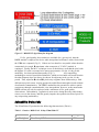
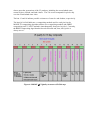
OBJECT
CLASS
NUM_ VA L
VA LUE
= A SSOCIATEDPLATFORMSHORTNAM E
= " 1"
=1
= "AM-1"
END_ OBJECT
OBJECT
CLASS
NUM_ VA L
VA LUE
= ASSOCIATEDPLATFORMSHORTNAME
= A SSOCIATEDINSTRUM ENTSHORTNAME
= " 1"
=1
= "MODIS"
END_ OBJECT
END_OBJECT
END_ GROUP
GROUP
OBJECT
CLASS
OBJECT
CLASS
NUM_ VA L
VA LUE
END_ OBJECT
GROUP
CLASS
OBJECT
NUM_ VA L
= ASSOCIATEDINSTRUM ENTSHORTNAME
= ASSOCIATEDPLATFORMINSTRUM ENTSENSORCONTAINER
= ASSOCIATEDPLATFORMINSTRUM ENTSENSOR
= ADDITIONA LATTRIBUTES
= ADDITIONA LATTRIBUTESCONTAINER
= "1"
= A DDITIONALATTRIBUTENAM E
= " 1"
=1
= "QAPERCENTGOODQUA LITY"
= ADDITIONA LATTRIBUTENAM E
= INFORMATIONCONTENT
= " 1"
= PARAM ETERVA LUE
=1
CLASS
= "1"
VA LUE
= "0"
END_OBJECT
= PA RAMETERVA LUE
END_ GROUP
END_OBJECT
OBJECT
CLASS
OBJECT
CLASS
NUM_ VA L
VA LUE
= INFORMATIONCONTENT
= ADDITIONA LATTRIBUTESCONTAINER
= "2"
= A DDITIONALATTRIBUTENAM E
= " 2"
=1
= "QAPERCENTOTHERQUA LITY"
END_ OBJECT
GROUP
CLASS
OBJECT
= ADDITIONA LATTRIBUTENAM E
= INFORMATIONCONTENT
= " 2"
= PARAM ETERVA LUE
NUM_ VA L
=1
CLASS
= "2"
VA LUE
= "100"
END_OBJECT
= PA RAMETERVA LUE
END_ GROUP
END_OBJECT
OBJECT
CLASS
OBJECT
CLASS
NUM_ VA L
VA LUE
END_ OBJECT
GROUP
CLASS
= INFORMATIONCONTENT
= ADDITIONA LATTRIBUTESCONTAINER
= "3"
= A DDITIONALATTRIBUTENAM E
= " 3"
=1
= "QAPERCENTNOTPRODUCEDCLOUD"
= ADDITIONA LATTRIBUTENAM E
= INFORMATIONCONTENT
= " 3"
OBJECT
= PARAM ETERVA LUE
NUM_ VA L
=1
CLASS
= "3"
VA LUE
= "0"
END_OBJECT
= PA RAMETERVA LUE
END_ GROUP
END_OBJECT
OBJECT
CLASS
OBJECT
CLASS
NUM_ VA L
VA LUE
= INFORMATIONCONTENT
= ADDITIONA LATTRIBUTESCONTAINER
= "4"
= A DDITIONALATTRIBUTENAM E
= " 4"
=1
= "QAPERCENTNOTPRODUCEDOTHER"
END_ OBJECT
GROUP
CLASS
OBJECT
= ADDITIONA LATTRIBUTENAM E
= INFORMATIONCONTENT
= " 4"
= PARAM ETERVA LUE
NUM_ VA L
=1
CLASS
= "4"
VA LUE
= "0"
END_OBJECT
= PA RAMETERVA LUE
END_ GROUP
END_OBJECT
OBJECT
CLASS
OBJECT
CLASS
= INFORMATIONCONTENT
= ADDITIONA LATTRIBUTESCONTAINER
= "5"
= A DDITIONALATTRIBUTENAM E
= " 5"
NUM_ VA L
VA LUE
=1
= "NDVI500M16DA YQCLASSPERCENTA GE"
END_ OBJECT
GROUP
CLASS
OBJECT
= ADDITIONA LATTRIBUTENAM E
= INFORMATIONCONTENT
= " 5"
= PARAM ETERVA LUE
NUM_ VA L
=1
CLASS
= "5"
VA LUE
= "0"
END_OBJECT
= PA RAMETERVA LUE
END_ GROUP
END_OBJECT
OBJECT
CLASS
OBJECT
CLASS
NUM_ VA L
VA LUE
END_ OBJECT
GROUP
CLASS
OBJECT
NUM_ VA L
= INFORMATIONCONTENT
= ADDITIONA LATTRIBUTESCONTAINER
= "6"
= A DDITIONALATTRIBUTENAM E
= " 6"
=1
= " EVI500M16DA YQCLA SSPERCENTA GE"
= ADDITIONA LATTRIBUTENAM E
= INFORMATIONCONTENT
= " 6"
= PARAM ETERVA LUE
=1
CLASS
= "6"
VA LUE
= "0"
END_OBJECT
END_ GROUP
= PA RAMETERVA LUE
= INFORMATIONCONTENT
END_OBJECT
OBJECT
CLASS
OBJECT
CLASS
NUM_ VA L
VA LUE
= ADDITIONA LATTRIBUTESCONTAINER
= "7"
= A DDITIONALATTRIBUTENAM E
= " 7"
=1
= "HORIZONTALTILENUMBER"
END_ OBJECT
GROUP
CLASS
OBJECT
= ADDITIONA LATTRIBUTENAM E
= INFORMATIONCONTENT
= " 7"
= PARAM ETERVA LUE
NUM_ VA L
=1
CLASS
= "7"
VA LUE
= "12"
END_OBJECT
= PA RAMETERVA LUE
END_ GROUP
END_OBJECT
OBJECT
CLASS
OBJECT
CLASS
NUM_ VA L
VA LUE
END_ OBJECT
GROUP
CLASS
OBJECT
= INFORMATIONCONTENT
= ADDITIONA LATTRIBUTESCONTAINER
= "8"
= A DDITIONALATTRIBUTENAM E
= " 8"
=1
= " VERTICALTILENUMBER"
= ADDITIONA LATTRIBUTENAM E
= INFORMATIONCONTENT
= " 8"
= PARAM ETERVA LUE
NUM_ VA L
=1
CLASS
= "8"
VA LUE
= "03"
END_OBJECT
= PA RAMETERVA LUE
END_ GROUP
END_OBJECT
OBJECT
CLASS
OBJECT
CLASS
NUM_ VA L
VA LUE
END_ OBJECT
GROUP
CLASS
OBJECT
NUM_ VA L
= INFORMATIONCONTENT
= ADDITIONA LATTRIBUTESCONTAINER
= "9"
= A DDITIONALATTRIBUTENAM E
= " 9"
=1
= "TileID"
= ADDITIONA LATTRIBUTENAM E
= INFORMATIONCONTENT
= " 9"
= PARAM ETERVA LUE
=1
CLASS
= "9"
VA LUE
= "11012003"
END_OBJECT
END_ GROUP
END_OBJECT
OBJECT
CLASS
OBJECT
CLASS
NUM_ VA L
= PA RAMETERVA LUE
= INFORMATIONCONTENT
= ADDITIONA LATTRIBUTESCONTAINER
= "10"
= A DDITIONALATTRIBUTENAM E
= " 10"
=1
VA LUE
= "PRODUCTRESOLUTION"
END_ OBJECT
= ADDITIONA LATTRIBUTENAM E
GROUP
= INFORMATIONCONTENT
CLASS
= " 1"
OBJECT
= PARAM ETERVA LUE
NUM_ VA L
=1
CLASS
= "10"
VA LUE
= "500m Product resolution"
END_OBJECT
= PA RAMETERVA LUE
END_ GROUP
END_OBJECT
END_ GROUP
END_ GROUP
= INFORMATIONCONTENT
= ADDITIONA LATTRIBUTESCONTAINER
= ADDITIONA LATTRIBUTES
= INVENTORYM ETADATA
END
ArchiveMetadata.0:
GROUP
GROUPTYPE
OBJECT
NUM_ VA L
VA LUE
END_OBJECT
OBJECT
NUM_ VA L
VA LUE
END_OBJECT
OBJECT
NUM_ VA L
VA LUE
= A RCHIVEDM ETADATA
= MASTERGROUP
= CHARA CTERISTICBINA NGULARSIZE
=1
= 15.000000
= CHA RACTERISTICBINANGULA RSIZE
= CHARA CTERISTICBINSIZE
=1
= 463.312717
= CHA RACTERISTICBINSIZE
= DATACOLUMNS
=1
= 2400
END_OBJECT
OBJECT
NUM_ VA L
VA LUE
END_OBJECT
OBJECT
NUM_ VA L
VA LUE
END_OBJECT
OBJECT
NUM_ VA L
VA LUE
END_OBJECT
OBJECT
NUM_ VA L
VA LUE
END_OBJECT
OBJECT
NUM_ VA L
VA LUE
END_OBJECT
OBJECT
NUM_ VA L
VA LUE
END_OBJECT
OBJECT
NUM_ VA L
= DATACOLUM NS
= DATAROWS
=1
= 2400
= DATAROWS
= GLOBA LGRIDCOLUM NS
=1
= 86400
= GLOBA LGRIDCOLUMNS
= GLOBA LGRIDROWS
=1
= 43200
= GLOBA LGRIDROWS
= NUM BEROFDA YS
=1
= 12
= NUM BEROFDA YS
= DA YSOFYEA R
= 16
= (129, 130, 132, 134, 135, 136, 138, 140, 141, 142, 143, 144, -1, -1, -1, -1)
= DA YSOFYEA R
= GEOA NYA BNORMA L
=1
= "True"
= GEOA NYA BNORMA L
= GEOESTMAXRM SERROR
=1
VA LUE
END_OBJECT
OBJECT
NUM_ VA L
VA LUE
END_OBJECT
OBJECT
NUM_ VA L
VA LUE
END_OBJECT
OBJECT
NUM_ VA L
VA LUE
END_OBJECT
OBJECT
NUM_ VA L
VA LUE
END_OBJECT
OBJECT
NUM_ VA L
VA LUE
END_OBJECT
OBJECT
NUM_ VA L
VA LUE
END_OBJECT
OBJECT
= 500.000000
= GEOESTMAXRMSERROR
= SPSOPA RAM ETERS
=4
= ("2749", " 4334", "2749a", "4334a")
= SPSOPA RAMETERS
= A LGORITHM PACKA GEA CCEPTA NCEDATE
=1
= "1998-01-01"
= A LGORITHMPA CKA GEACCEPTANCEDATE
= A LGORITHM PACKA GEMATURITYCODE
=1
= "LA UNCH"
= A LGORITHMPA CKA GEMATURITYCODE
= A LGORITHM PACKA GENAME
=1
= "MOD13A1"
= A LGORITHMPA CKA GENAME
= A LGORITHM PACKA GEVERSION
=1
= "2"
= A LGORITHMPA CKA GEVERSION
= INSTRUM ENTNAME
=1
= "Moderate-Resolution Imaging SpectroRad io meter"
= INSTRUM ENTNAM E
= LONGNAME
NUM_ VA L
VA LUE
END_OBJECT
OBJECT
NUM_ VA L
VA LUE
END_OBJECT
OBJECT
NUM_ VA L
=1
= "MODIS Vegetation Index (16 day 250m/ 500m)"
= LONGNAM E
= PROCESSINGCENTER
=1
= "MODAPS"
= PROCESSINGCENTER
= INPUTFILENAM E
= 160
VA LUE
= ("MOD09GHK.A 2000129.h12v03.001.2000141075429.hdf",
"MOD09GHK.A2000130.h12v03.001.2000142041234.hdf",
"MOD09GHK.A2000132.h12v03.001.2000160053350.hdf",
"MOD09GHK.A2000134.h12v03.001.2000144220328.hdf",
"MOD09GHK.A2000135.h12v03.001.2000154031029.hdf", "
MOD09GHK.A 2000136.h12v03.001.2000158082455.hdf",
"MOD09GHK.A2000138.h12v03.001.2000153185705.hdf",
"MOD09GHK.A2000140.h12v03.001.2000147061411.hdf",
"MOD09GHK.A2000141.h12v03.001.2000161002506.hdf",
"MOD09GHK.A2000142.h12v03.001.2000148130723.hdf", "
MOD09GHK.A 2000143.h12v03.001.2000149081545.hdf",
"MOD09GHK.A2000144.h12v03.001.2000149230504.hdf",
"MODPTHKM .A2000129.h 12v 03.001.2000141073858.hdf",
"MODPTHKM .A2000130.h 12v 03.001.2000142040658.hdf",
"MODPTHKM .A2000132.h 12v 03.001.2000160051253.hdf", "
MODPTHKM.A2000134.h 12v03.001.2000144215620.hdf",
"MODPTHKM .A2000135.h 12v 03.001.2000154025448.hdf",
"MODPTHKM .A2000136.h 12v 03.001.2000158081928.hdf",
"MODPTHKM .A2000138.h 12v 03.001.2000153182654.hdf",
"MODPTHKM .A2000140.h 12v 03.001.2000147060121.hdf", "
MODPTHKM.A2000141.h 12v03.001.2000161002034.hdf",
"MODPTHKM .A2000142.h 12v 03.001.2000148124614.hdf",
"MODPTHKM .A2000143.h 12v 03.001.2000149073716.hdf",
"MODPTHKM .A2000144.h 12v 03.001.2000149225454.hdf",
"MOD09GST.A 2000129.h12v03.001.2000141074039.hdf", "
MOD09GST.A2000130.h 12v 03.001.2000142040805.hdf",
"MOD09GST.A 2000132.h12v03.001.2000160051656.hdf",
"MOD09GST.A 2000134.h12v03.001.2000144215648.hdf",
"MOD09GST.A 2000135.h12v03.001.2000154025947.hdf",
"MOD09GST.A 2000136.h12v03.001.2000158082022.hdf", "
MOD09GST.A2000138.h 12v 03.001.2000153183355.hdf",
"MOD09GST.A 2000140.h12v03.001.2000147060458.hdf",
"MOD09GST.A 2000141.h12v03.001.2000161002222.hdf",
"MOD09GST.A 2000142.h12v03.001.2000148125032.hdf",
"MOD09GST.A 2000143.h12v03.001.2000149074236.hdf", "
MOD09GST.A2000144.h 12v 03.001.2000149225650.hdf",
"MODM GGA D.A 2000129.h12v03.001.2000141074013.hdf",
"MODM GGA D.A 2000130.h12v03.001.2000142040725.hdf",
"MODM GGA D.A 2000132.h12v03.001.2000160051520.hdf",
"MODM GGA D.A 2000134.h12v03.001.2000144215630.hdf", "
MODM GGAD.A2000135.h 12v 03.001.2000154025805.hdf",
"MODM GGA D.A 2000136.h12v03.001.2000158081952.hdf",
"MODM GGA D.A 2000138.h12v03.001.2000153182947.hdf",
"MODM GGA D.A 2000140.h12v03.001.2000147060323.hdf",
"MODM GGA D.A 2000141.h12v03.001.2000161002052.hdf", "
MODM GGAD.A2000142.h 12v 03.001.2000148124812.hdf",
"MODM GGA D.A 2000143.h12v03.001.2000149074004.hdf",
"MODM GGA D.A 2000144.h12v03.001.2000149225558.hdf")
END_OBJECT
OBJECT
NUM_ VA L
VA LUE
END_OBJECT
OBJECT
NUM_ VA L
VA LUE
END_OBJECT
GROUP
OBJECT
NUM_ VA L
VA LUE
END_OBJECT
OBJECT
NUM_ VA L
VA LUE
END_OBJECT
= INPUTFILENAM E
= QAPERCENTPOORQ250MOR500M 16DA YNDVI
= 16
= (0, 0, 0, 0, 50, 19, 24, 5, 0, 2, 0, 0, 0, 0, 0, 0)
= QAPERCENTPOORQ250MOR500M 16DA YNDVI
= QAPERCENTPOORQ250MOR500M 16DA YEVI
= 16
= (0, 0, 0, 0, 49, 19, 24, 5, 0, 2, 0, 0, 0, 0, 0, 1)
= QAPERCENTPOORQ250MOR500M 16DA YEVI
= BOUNDINGRECTANGLE
= NORTHBOUNDINGCOORDINATE
=1
= 60.000000
= NORTHBOUNDINGCOORDINATE
= SOUTHBOUNDINGCOORDINATE
=1
= 50.000000
= SOUTHBOUNDINGCOORDINATE
OBJECT
NUM_ VA L
VA LUE
END_OBJECT
OBJECT
NUM_ VA L
VA LUE
END_OBJECT
END_ GROUP
OBJECT
NUM_ VA L
VA LUE
END_OBJECT
OBJECT
NUM_ VA L
VA LUE
END_OBJECT
OBJECT
NUM_ VA L
VA LUE
END_OBJECT
END_ GROUP
END
= EASTBOUNDINGCOORDINATE
=1
= -77.792984
= EASTBOUNDINGCOORDINATE
= W ESTBOUNDINGCOORDINATE
=1
= -119.975003
= WESTBOUNDINGCOORDINATE
= BOUNDINGRECTANGLE
= PERCENTLA ND
=1
= 100
= PERCENTLA ND
= SEAPROCESSED
=1
= " Yes"
= SEA PROCESSED
= DESCRREVISION
=1
= "1.0"
= DESCRREVISION
= ARCHIVEDM ETADATA
APPENDIX 2
MOD13A2 Global and Local Metadata
Attributes
Structural Metdata
StructMetadata.0: GROUP=Sw athStructure
END_GROUP=Sw athStructure
GROUP=GridStructure
GROUP=GRID_1
GridName="MODIS_ Grid_16DA Y_1km_ VI"
XDim=1200
YDim=1200
UpperLeftPointMtrs=(-6671703.118599,6671703.118599)
LowerRightMtrs=(-5559752.598833,5559752.598833)
Projection=GCTP_ISINUS
ProjParams=(6371007.181000,0,0,0,0,0,0,0,21600,0,1,0,0)
SphereCode=-1
GROUP=Dimension
END_ GROUP=Dimension
GROUP=DataField
OBJECT=DataField_1
DataField Name=" 1 km 16 days NDVI"
DataType=DFNT_INT16
DimList=(" YDim"," XDim")
END_ OBJECT=DataField_1
OBJECT=DataField_2
DataField Name=" 1 km 16 days EVI"
DataType=DFNT_INT16
DimList=(" YDim"," XDim")
END_ OBJECT=DataField_2
OBJECT=DataField_3
DataField Name=" 1 km 16 days NDVI Quality"
DataType=DFNT_ UINT16
DimList=(" YDim"," XDim")
END_ OBJECT=DataField_3
OBJECT=DataField_4
DataField Name=" 1 km 16 days EVI Quality"
DataType=DFNT_ UINT16
DimList=(" YDim"," XDim")
END_ OBJECT=DataField_4
OBJECT=DataField_5
DataField Name=" 1 km 16 days red reflectance"
DataType=DFNT_INT16
DimList=(" YDim"," XDim")
END_ OBJECT=DataField_5
OBJECT=DataField_6
DataField Name=" 1 km 16 days NIR reflectance"
DataType=DFNT_INT16
DimList=(" YDim"," XDim")
END_ OBJECT=DataField_6
OBJECT=DataField_7
DataField Name=" 1 km 16 days blue reflectance"
DataType=DFNT_INT16
DimList=(" YDim"," XDim")
END_ OBJECT=DataField_7
OBJECT=DataField_8
DataField Name=" 1 km 16 days MIR reflectance"
DataType=DFNT_INT16
DimList=(" YDim"," XDim")
END_ OBJECT=DataField_8
OBJECT=DataField_9
DataField Name=" 1 km 16 days average view zenith angle"
DataType=DFNT_INT16
DimList=(" YDim"," XDim")
END_ OBJECT=DataField_9
OBJECT=DataField_10
DataField Name=" 1 km 16 days average sun zenith angle"
DataType=DFNT_INT16
DimList=(" YDim"," XDim")
END_ OBJECT=DataField_10
OBJECT=DataField_11
DataField Name=" 1 km 16 days average relative azimuth
angle"
DataType=DFNT_INT16
DimList=(" YDim"," XDim")
END_ OBJECT=DataField_11
END_ GROUP=DataField
GROUP=MergedFields
END_ GROUP=MergedFields
END_ GROUP=GRID_1
END_GROUP=GridStructure
GROUP=PointStructure
END_GROUP=PointStructure
END
CoreMetadata
Inventory Metdata
GROUP
GROUPTYPE
= INVENTORYM ETADATA
= MASTERGROUP
GROUP
= ECSDATA GRANULE
OBJECT
= LOCA LGRA NULEID
NUM_ VA L
VA LUE
END_ OBJECT
OBJECT
NUM_ VA L
VA LUE
END_ OBJECT
OBJECT
NUM_ VA L
VA LUE
END_ OBJECT
OBJECT
NUM_ VA L
VA LUE
END_OBJECT
OBJECT
NUM_ VA L
VA LUE
END_OBJECT
END_ GROUP
GROUP
=1
= "MOD13A 2.A2000129.h12v03.002.2000172115628.hdf"
= LOCA LGRANULEID
= PRODUCTIONDATETIM E
=1
= " 2000-06-20T15:56:28.000Z"
= PRODUCTIONDAT ETIM E
= DA YNIGHTFLA G
=1
= " Both"
= DA YNIGHTFLA G
= REPROCESSINGA CTUA L
=1
= "processed once"
= REPROCESSINGA CTUA L
= REPROCESSINGPLANNED
=1
= "further update anticipated"
= REPROCESSINGPLANNED
= ECSDATA GRANULE
= M EASUREDPARAM ETER
OBJECT
CLASS
GROUP
CLASS
OBJECT
NUM_ VA L
= M EASUREDPARAM ETERCONTAINER
= "1"
= QAFLA GS
= " 1"
= AUTOMATICQUA LITYFLA GEXPLA NATION
=1
CLASS
= "1"
VA LUE
= "Product will be evaluated after launch"
END_OBJECT
OBJECT
NUM_ VA L
= AUTOMATICQUA LITYFLA GEXPLA NATION
= AUTOMATICQUA LITYFLA G
=1
CLASS
= "1"
VA LUE
= "Suspect"
END_OBJECT
END_ GROUP
GROUP
CLASS
OBJECT
NUM_ VA L
= AUTOMATICQUA LITYFLA G
= QA FLA GS
= QASTATS
= " 1"
= QAPERCENTMISSINGDATA
=1
CLASS
= "1"
VA LUE
=0
END_OBJECT
OBJECT
NUM_ VA L
= QAPERCENTM ISSINGDATA
= QAPERCENTOUTOFBOUNDSDATA
=1
CLASS
= "1"
VA LUE
=0
END_OBJECT
= QAPERCENTOUTOFBOUNDSDATA
OBJECT
= QAPERCENTCLOUDCOVER
NUM_ VA L
=1
CLASS
= "1"
VA LUE
= 15
END_OBJECT
OBJECT
= QAPERCENTCLOUDCOVER
= QAPERCENTINTERPOLATEDDATA
NUM_ VA L
=1
CLASS
= "1"
VA LUE
=0
END_OBJECT
= QAPERCENTINTERPOLATEDDATA
END_ GROUP
OBJECT
CLASS
NUM_ VA L
VA LUE
= QA STATS
= PARAM ETERNAM E
= " 1"
=1
= "1 km 16 days NDVI"
END_ OBJECT
END_OBJECT
OBJECT
CLASS
GROUP
CLASS
OBJECT
NUM_ VA L
= PARAM ETERNAME
= M EASUREDPA RAM ETERCONTAINER
= M EASUREDPARAM ETERCONTAINER
= "2"
= QAFLA GS
= " 2"
= AUTOMATICQUA LITYFLA GEXPLA NATION
=1
CLASS
= "2"
VA LUE
= "Product will be evaluated after launch"
END_OBJECT
OBJECT
= AUTOMATICQUA LITYFLA GEXPLA NATION
= AUTOMATICQUA LITYFLA G
NUM_ VA L
=1
CLASS
= "2"
VA LUE
= "Suspect"
END_OBJECT
END_ GROUP
GROUP
CLASS
OBJECT
NUM_ VA L
= AUTOMATICQUA LITYFLA G
= QA FLA GS
= QASTATS
= " 2"
= QAPERCENTMISSINGDATA
=1
CLASS
= "2"
VA LUE
=0
END_OBJECT
OBJECT
NUM_ VA L
= QAPERCENTM ISSINGDATA
= QAPERCENTOUTOFBOUNDSDATA
=1
CLASS
= "2"
VA LUE
=0
END_OBJECT
OBJECT
NUM_ VA L
= QAPERCENTOUTOFBOUNDSDATA
= QAPERCENTCLOUDCOVER
=1
CLASS
= "2"
VA LUE
= 15
END_OBJECT
OBJECT
NUM_ VA L
= QAPERCENTCLOUDCOVER
= QAPERCENTINTERPOLATEDDATA
=1
CLASS
= "2"
VA LUE
=0
END_OBJECT
= QAPERCENTINTERPOLATEDDATA
END_ GROUP
OBJECT
CLASS
NUM_ VA L
VA LUE
= QA STATS
= PARAM ETERNAM E
= " 2"
=1
= "1 km 16 days EVI"
END_ OBJECT
END_OBJECT
OBJECT
CLASS
GROUP
CLASS
OBJECT
NUM_ VA L
= PARAM ETERNAME
= M EASUREDPA RAM ETERCONTAINER
= M EASUREDPARAM ETERCONTAINER
= "3"
= QAFLA GS
= " 3"
= AUTOMATICQUA LITYFLA GEXPLA NATION
=1
CLASS
= "3"
VA LUE
= "Product will be evaluated after launch"
END_OBJECT
OBJECT
NUM_ VA L
= AUTOMATICQUA LITYFLA GEXPLA NATION
= AUTOMATICQUA LITYFLA G
=1
CLASS
= "3"
VA LUE
= "Suspect"
END_OBJECT
END_ GROUP
GROUP
CLASS
OBJECT
NUM_ VA L
CLASS
= AUTOMATICQUA LITYFLA G
= QA FLA GS
= QASTATS
= " 3"
= QAPERCENTMISSINGDATA
=1
= "3"
VA LUE
=0
END_OBJECT
OBJECT
= QAPERCENTM ISSINGDATA
= QAPERCENTOUTOFBOUNDSDATA
NUM_ VA L
=1
CLASS
= "3"
VA LUE
=0
END_OBJECT
OBJECT
= QAPERCENTOUTOFBOUNDSDATA
= QAPERCENTCLOUDCOVER
NUM_ VA L
=1
CLASS
= "3"
VA LUE
= 15
END_OBJECT
OBJECT
= QAPERCENTCLOUDCOVER
= QAPERCENTINTERPOLATEDDATA
NUM_ VA L
=1
CLASS
= "3"
VA LUE
=0
END_OBJECT
= QAPERCENTINTERPOLATEDDATA
END_ GROUP
OBJECT
CLASS
NUM_ VA L
VA LUE
= QA STATS
= PARAM ETERNAM E
= " 3"
=1
= "1 km 16 days NDVI Quality"
END_ OBJECT
END_OBJECT
OBJECT
CLASS
GROUP
= PARAM ETERNAME
= M EASUREDPA RAM ETERCONTAINER
= M EASUREDPARAM ETERCONTAINER
= "4"
= QAFLA GS
CLASS
OBJECT
NUM_ VA L
= " 4"
= AUTOMATICQUA LITYFLA GEXPLA NATION
=1
CLASS
= "4"
VA LUE
= "Product will be evaluated after launch"
END_OBJECT
OBJECT
NUM_ VA L
= AUTOMATICQUA LITYFLA GEXPLA NATION
= AUTOMATICQUA LITYFLA G
=1
CLASS
= "4"
VA LUE
= "Suspect"
END_OBJECT
END_ GROUP
GROUP
CLASS
OBJECT
NUM_ VA L
= AUTOMATICQUA LITYFLA G
= QA FLA GS
= QASTATS
= " 4"
= QAPERCENTMISSINGDATA
=1
CLASS
= "4"
VA LUE
=0
END_OBJECT
OBJECT
NUM_ VA L
= QAPERCENTM ISSINGDATA
= QAPERCENTOUTOFBOUNDSDATA
=1
CLASS
= "4"
VA LUE
=0
END_OBJECT
OBJECT
NUM_ VA L
CLASS
= QAPERCENTOUTOFBOUNDSDATA
= QAPERCENTCLOUDCOVER
=1
= "4"
VA LUE
= 15
END_OBJECT
OBJECT
= QAPERCENTCLOUDCOVER
= QAPERCENTINTERPOLATEDDATA
NUM_ VA L
=1
CLASS
= "4"
VA LUE
=0
END_OBJECT
= QAPERCENTINTERPOLATEDDATA
END_ GROUP
OBJECT
CLASS
NUM_ VA L
VA LUE
= QA STATS
= PARAM ETERNAME
= " 4"
=1
= "1 km 16 days EVI Quality"
END_ OBJECT
END_OBJECT
OBJECT
CLASS
GROUP
CLASS
OBJECT
NUM_ VA L
= PARAM ETERNAME
= M EASUREDPA RAM ETERCONTAINER
= M EASUREDPARAM ETERCONTAINER
= "5"
= QAFLA GS
= " 5"
= AUTOMATICQUA LITYFLA GEXPLA NATION
=1
CLASS
= "5"
VA LUE
= "Product will be evaluated after launch"
END_OBJECT
OBJECT
NUM_ VA L
= AUTOMATICQUA LITYFLA GEXPLA NATION
= AUTOMATICQUA LITYFLA G
=1
CLASS
= "5"
VA LUE
= "Suspect"
END_OBJECT
END_ GROUP
GROUP
CLASS
OBJECT
NUM_ VA L
= AUTOMATICQUA LITYFLA G
= QA FLA GS
= QASTATS
= " 5"
= QAPERCENTMISSINGDATA
=1
CLASS
= "5"
VA LUE
=0
END_OBJECT
OBJECT
NUM_ VA L
= QAPERCENTM ISSINGDATA
= QAPERCENTOUTOFBOUNDSDATA
=1
CLASS
= "5"
VA LUE
=0
END_OBJECT
OBJECT
NUM_ VA L
= QAPERCENTOUTOFBOUNDSDATA
= QAPERCENTCLOUDCOVER
=1
CLASS
= "5"
VA LUE
= 15
END_OBJECT
OBJECT
NUM_ VA L
= QAPERCENTCLOUDCOVER
= QAPERCENTINTERPOLATEDDATA
=1
CLASS
= "5"
VA LUE
=0
END_OBJECT
END_ GROUP
OBJECT
CLASS
= QAPERCENTINTERPOLATEDDATA
= QA STATS
= PARAM ETERNAM E
= " 5"
NUM_ VA L
VA LUE
=1
= "1 km 16 days red reflectance"
END_ OBJECT
END_OBJECT
OBJECT
CLASS
GROUP
CLASS
OBJECT
NUM_ VA L
= PARAM ETERNAME
= M EASUREDPA RAM ETERCONTAINER
= M EASUREDPARAM ETERCONTAINER
= "6"
= QAFLA GS
= " 6"
= AUTOMATICQUA LITYFLA GEXPLA NATION
=1
CLASS
= "6"
VA LUE
= "Product will be evaluated after launch"
END_OBJECT
OBJECT
NUM_ VA L
= AUTOMATICQUA LITYFLA GEXPLA NATION
= AUTOMATICQUA LITYFLA G
=1
CLASS
= "6"
VA LUE
= "Suspect"
END_OBJECT
END_ GROUP
GROUP
CLASS
OBJECT
NUM_ VA L
= AUTOMATICQUA LITYFLA G
= QA FLA GS
= QASTATS
= " 6"
= QAPERCENTMISSINGDATA
=1
CLASS
= "6"
VA LUE
=0
END_OBJECT
OBJECT
= QAPERCENTM ISSINGDATA
= QAPERCENTOUTOFBOUNDSDATA
NUM_ VA L
=1
CLASS
= "6"
VA LUE
=0
END_OBJECT
OBJECT
= QAPERCENTOUTOFBOUNDSDATA
= QAPERCENTCLOUDCOVER
NUM_ VA L
=1
CLASS
= "6"
VA LUE
= 15
END_OBJECT
OBJECT
= QAPERCENTCLOUDCOVER
= QAPERCENTINTERPOLATEDDATA
NUM_ VA L
=1
CLASS
= "6"
VA LUE
=0
END_OBJECT
= QAPERCENTINTERPOLATEDDATA
END_ GROUP
OBJECT
CLASS
NUM_ VA L
VA LUE
= QA STATS
= PARAM ETERNAM E
= " 6"
=1
= "1 km 16 days NIR reflectance"
END_ OBJECT
END_OBJECT
OBJECT
CLASS
GROUP
CLASS
OBJECT
NUM_ VA L
= PARAM ETERNAME
= M EASUREDPA RAM ETERCONTAINER
= M EASUREDPARAM ETERCONTAINER
= "7"
= QAFLA GS
= " 7"
= AUTOMATICQUA LITYFLA GEXPLA NATION
=1
CLASS
= "7"
VA LUE
= "Product will be evaluated after launch"
END_OBJECT
OBJECT
NUM_ VA L
= AUTOMATICQUA LITYFLA GEXPLA NATION
= AUTOMATICQUA LITYFLA G
=1
CLASS
= "7"
VA LUE
= "Suspect"
END_OBJECT
END_ GROUP
GROUP
CLASS
OBJECT
NUM_ VA L
= AUTOMATICQUA LITYFLA G
= QA FLA GS
= QASTATS
= " 7"
= QAPERCENTMISSINGDATA
=1
CLASS
= "7"
VA LUE
=0
END_OBJECT
OBJECT
NUM_ VA L
= QAPERCENTM ISSINGDATA
= QAPERCENTOUTOFBOUNDSDATA
=1
CLASS
= "7"
VA LUE
=0
END_OBJECT
OBJECT
NUM_ VA L
= QAPERCENTOUTOFBOUNDSDATA
= QAPERCENTCLOUDCOVER
=1
CLASS
= "7"
VA LUE
= 15
END_OBJECT
OBJECT
= QAPERCENTCLOUDCOVER
= QAPERCENTINTERPOLATEDDATA
NUM_ VA L
=1
CLASS
= "7"
VA LUE
=0
END_OBJECT
= QAPERCENTINTERPOLATEDDATA
END_ GROUP
OBJECT
CLASS
NUM_ VA L
VA LUE
= QA STATS
= PARAM ETERNAM E
= " 7"
=1
= "1 km 16 days blue reflectance"
END_ OBJECT
END_OBJECT
OBJECT
CLASS
GROUP
CLASS
OBJECT
NUM_ VA L
= PARAM ETERNAME
= M EASUREDPA RAM ETERCONTAINER
= M EASUREDPARAM ETERCONTAINER
= "8"
= QAFLA GS
= " 8"
= AUTOMATICQUA LITYFLA GEXPLA NATION
=1
CLASS
= "8"
VA LUE
= "Product will be evaluated after launch"
END_OBJECT
OBJECT
NUM_ VA L
= AUTOMATICQUA LITYFLA GEXPLA NATION
= AUTOMATICQUA LITYFLA G
=1
CLASS
= "8"
VA LUE
= "Suspect"
END_OBJECT
END_ GROUP
GROUP
= AUTOMATICQUA LITYFLA G
= QA FLA GS
= QASTATS
CLASS
OBJECT
NUM_ VA L
= " 8"
= QAPERCENTMISSINGDATA
=1
CLASS
= "8"
VA LUE
=0
END_OBJECT
OBJECT
NUM_ VA L
= QAPERCENTM ISSINGDATA
= QAPERCENTOUTOFBOUNDSDATA
=1
CLASS
= "8"
VA LUE
=0
END_OBJECT
OBJECT
NUM_ VA L
= QAPERCENTOUTOFBOUNDSDATA
= QAPERCENTCLOUDCOVER
=1
CLASS
= "8"
VA LUE
= 15
END_OBJECT
OBJECT
NUM_ VA L
= QAPERCENTCLOUDCOVER
= QAPERCENTINTERPOLATEDDATA
=1
CLASS
= "8"
VA LUE
=0
END_OBJECT
END_ GROUP
OBJECT
CLASS
NUM_ VA L
VA LUE
END_ OBJECT
= QAPERCENTINTERPOLATEDDATA
= QA STATS
= PARAM ETERNAM E
= " 8"
=1
= "1 km 16 days MIR reflectance"
= PARAM ETERNAME
END_OBJECT
OBJECT
CLASS
GROUP
CLASS
OBJECT
NUM_ VA L
= M EASUREDPA RAM ETERCONTAINER
= M EASUREDPARAM ETERCONTAINER
= "9"
= QAFLA GS
= " 9"
= AUTOMATICQUA LITYFLA GEXPLA NATION
=1
CLASS
= "9"
VA LUE
= "Product will be evaluated after launch"
END_OBJECT
OBJECT
NUM_ VA L
= AUTOMATICQUA LITYFLA GEXPLA NATION
= AUTOMATICQUA LITYFLA G
=1
CLASS
= "9"
VA LUE
= "Suspect"
END_OBJECT
END_ GROUP
GROUP
CLASS
OBJECT
NUM_ VA L
= AUTOMATICQUA LITYFLA G
= QA FLA GS
= QASTATS
= " 9"
= QAPERCENTMISSINGDATA
=1
CLASS
= "9"
VA LUE
=0
END_OBJECT
OBJECT
NUM_ VA L
= QAPERCENTM ISSINGDATA
= QAPERCENTOUTOFBOUNDSDATA
=1
CLASS
= "9"
VA LUE
=0
END_OBJECT
OBJECT
NUM_ VA L
= QAPERCENTOUTOFBOUNDSDATA
= QAPERCENTCLOUDCOVER
=1
CLASS
= "9"
VA LUE
= 15
END_OBJECT
OBJECT
NUM_ VA L
= QAPERCENTCLOUDCOVER
= QAPERCENTINTERPOLATEDDATA
=1
CLASS
= "9"
VA LUE
=0
END_OBJECT
END_ GROUP
OBJECT
CLASS
NUM_ VA L
VA LUE
END_ OBJECT
END_OBJECT
OBJECT
CLASS
GROUP
CLASS
OBJECT
NUM_ VA L
= QAPERCENTINTERPOLATEDDATA
= QA STATS
= PARAM ETERNAM E
= " 9"
=1
= "1 km 16 days average view zen ith angle"
= PARAM ETERNAME
= M EASUREDPA RAM ETERCONTAINER
= M EASUREDPARAM ETERCONTAINER
= "10"
= QAFLA GS
= " 1"
= AUTOMATICQUA LITYFLA GEXPLA NATION
=1
CLASS
= "10"
VA LUE
= "Product will be evaluated after launch"
END_OBJECT
= AUTOMATICQUA LITYFLA GEXPLA NATION
OBJECT
NUM_ VA L
= AUTOMATICQUA LITYFLA G
=1
CLASS
= "10"
VA LUE
= "Suspect"
END_OBJECT
END_ GROUP
GROUP
CLASS
OBJECT
NUM_ VA L
= AUTOMATICQUA LITYFLA G
= QA FLA GS
= QASTATS
= " 1"
= QAPERCENTMISSINGDATA
=1
CLASS
= "10"
VA LUE
=0
END_OBJECT
OBJECT
NUM_ VA L
= QAPERCENTM ISSINGDATA
= QAPERCENTOUTOFBOUNDSDATA
=1
CLASS
= "10"
VA LUE
=0
END_OBJECT
OBJECT
NUM_ VA L
= QAPERCENTOUTOFBOUNDSDATA
= QAPERCENTCLOUDCOVER
=1
CLASS
= "10"
VA LUE
= 15
END_OBJECT
OBJECT
NUM_ VA L
= QAPERCENTCLOUDCOVER
= QAPERCENTINTERPOLATEDDATA
=1
CLASS
= "10"
VA LUE
=0
END_OBJECT
END_ GROUP
OBJECT
CLASS
NUM_ VA L
VA LUE
END_ OBJECT
END_OBJECT
OBJECT
CLASS
GROUP
CLASS
OBJECT
NUM_ VA L
= QAPERCENTINTERPOLATEDDATA
= QA STATS
= PARAM ETERNAM E
= " 10"
=1
= "1 km 16 days average sun zenith angle"
= PARAM ETERNAME
= M EASUREDPA RAM ETERCONTAINER
= M EASUREDPARAM ETERCONTAINER
= "11"
= QAFLA GS
= " 1"
= AUTOMATICQUA LITYFLA GEXPLA NATION
=1
CLASS
= "11"
VA LUE
= "Product will be evaluated after launch"
END_OBJECT
OBJECT
NUM_ VA L
= AUTOMATICQUA LITYFLA GEXPLA NATION
= AUTOMATICQUA LITYFLA G
=1
CLASS
= "11"
VA LUE
= "Suspect"
END_OBJECT
END_ GROUP
GROUP
CLASS
OBJECT
NUM_ VA L
= AUTOMATICQUA LITYFLA G
= QA FLA GS
= QASTATS
= " 1"
= QAPERCENTMISSINGDATA
=1
CLASS
= "11"
VA LUE
=0
END_OBJECT
OBJECT
NUM_ VA L
= QAPERCENTM ISSINGDATA
= QAPERCENTOUTOFBOUNDSDATA
=1
CLASS
= "11"
VA LUE
=0
END_OBJECT
OBJECT
NUM_ VA L
= QAPERCENTOUTOFBOUNDSDATA
= QAPERCENTCLOUDCOVER
=1
CLASS
= "11"
VA LUE
= 15
END_OBJECT
OBJECT
NUM_ VA L
= QAPERCENTCLOUDCOVER
= QAPERCENTINTERPOLATEDDATA
=1
CLASS
= "11"
VA LUE
=0
END_OBJECT
END_ GROUP
OBJECT
CLASS
NUM_ VA L
VA LUE
END_ OBJECT
END_OBJECT
END_ GROUP
GROUP
= QAPERCENTINTERPOLATEDDATA
= QA STATS
= PARAM ETERNAM E
= " 11"
=1
= "1 km 16 days average relative azimuth angle"
= PARAM ETERNAME
= M EASUREDPA RAM ETERCONTAINER
= M EASUREDPA RAMETER
= COLLECTIONDESCRIPTIONCLASS
OBJECT
NUM_ VA L
VA LUE
END_OBJECT
OBJECT
NUM_ VA L
VA LUE
END_OBJECT
END_ GROUP
GROUP
OBJECT
NUM_ VA L
= VERSIONID
=1
=1
= VERSIONID
= SHORTNAM E
=1
= "MOD13A 2"
= SHORTNAM E
= COLLECTIONDESCRIPTIONCLASS
= INPUTGRA NULE
= INPUTPOINTER
= 16
VA LUE
= ("MODA GA GG.A2000129.h12v03.002.2000141041139.hdf",
"MODA GA GG.A2000130.h12v03.002.2000142002530.hdf",
"MODA GA GG.A2000134.h12v03.002.2000144180903.hdf",
"MODA GA GG.A2000138.h12v03.002.2000153152724.hdf",
"MODA GA GG.A2000139.h12v03.002.2000146065616.hdf", "
M ODA GA GG.A2000140.h12v03.002.2000147023341.hdf" ,
"MODA GA GG.A2000142.h12v03.002.2000148093933.hdf",
"MODA GA GG.A2000143.h12v03.002.2000149044849.hdf",
"MODA GA GG.A2000144.h12v03.002.2000149191241.hdf")
END_OBJECT
END_ GROUP
GROUP
GROUP
GROUP
OBJECT
CLASS
GROUP
CLASS
OBJECT
= INPUTPOINTER
= INPUTGRA NULE
= SPATIA LDOMAINCONTAINER
= HORIZONTALSPATIA LDOMAINCONTAINER
= GPOLYGON
= GPOLYGONCONTAINER
= "1"
= GRINGPOINT
= "1"
= GRINGPOINTLONGITUDE
NUM_ VA L
CLASS
VA LUE
=4
= " 1"
= (-119.975003, -99.977781, -77.792984, -93.351581)
END_ OBJECT
OBJECT
NUM_ VA L
CLASS
VA LUE
= GRINGPOINTLONGITUDE
= GRINGPOINTLATITUDE
=4
= " 1"
= (60.000000, 60.000000, 50.000000, 50.000000)
END_ OBJECT
OBJECT
NUM_ VA L
CLASS
VA LUE
= GRINGPOINTLATITUDE
= GRINGPOINTSEQUENCENO
=4
= " 1"
= (1, 2, 3, 4)
END_ OBJECT
END_ GROUP
GROUP
CLASS
OBJECT
NUM_ VA L
CLASS
VA LUE
END_ OBJECT
END_ GROUP
END_OBJECT
END_ GROUP
END_ GROUP
END_ GROUP
= GRINGPOINTSEQUENCENO
= GRINGPOINT
= GRING
= "1"
= EXCLUSIONGRINGFLA G
=1
= " 1"
= "N"
= EXCLUSIONGRINGFLA G
= GRING
= GPOLYGONCONTAINER
= GPOLYGON
= HORIZONTA LSPATIA LDOMAINCONTAINER
= SPATIALDOMAINCONTAINER
GROUP
OBJECT
NUM_ VA L
VA LUE
END_OBJECT
OBJECT
NUM_ VA L
VA LUE
END_OBJECT
OBJECT
NUM_ VA L
VA LUE
END_OBJECT
OBJECT
NUM_ VA L
VA LUE
END_OBJECT
END_ GROUP
GROUP
OBJECT
NUM_ VA L
VA LUE
END_OBJECT
END_ GROUP
GROUP
OBJECT
CLASS
= RANGEDATETIM E
= RANGEENDINGDATE
=1
= " 2000-05-23"
= RA NGEENDINGDATE
= RANGEENDINGTIM E
=1
= " 20:00:00.000000"
= RA NGEENDINGTIM E
= RANGEBEGINNINGDATE
=1
= " 2000-05-08"
= RA NGEBEGINNINGDATE
= RANGEBEGINNINGTIM E
=1
= " 07:10:00.000000"
= RA NGEBEGINNINGTIM E
= RA NGEDATETIM E
= PGEVERSIONCLASS
= PGEVERSION
=1
= " 2.2.1"
= PGEVERSION
= PGEVERSIONCLA SS
= ASSOCIATEDPLATFORMINSTRUM ENTSENSOR
= A SSOCIATEDPLATFORMINSTRUM ENTSENSORCONTAINER
= "1"
OBJECT
CLASS
NUM_ VA L
VA LUE
= A SSOCIATEDSENSORSHORTNAM E
= " 1"
=1
= "CCD"
END_ OBJECT
OBJECT
CLASS
NUM_ VA L
VA LUE
= ASSOCIATEDSENSORSHORTNAME
= A SSOCIATEDPLATFORMSHORTNAM E
= " 1"
=1
= "AM-1"
END_ OBJECT
OBJECT
CLASS
NUM_ VA L
VA LUE
= ASSOCIATEDPLATFORMSHORTNAME
= A SSOCIATEDINSTRUM ENTSHORTNAME
= " 1"
=1
= "MODIS"
END_ OBJECT
END_OBJECT
END_ GROUP
GROUP
OBJECT
CLASS
OBJECT
CLASS
NUM_ VA L
VA LUE
END_ OBJECT
GROUP
CLASS
= ASSOCIATEDINSTRUM ENTSHORTNAME
= ASSOCIATEDPLATFORMINSTRUM ENTSENSORCONTAINER
= ASSOCIATEDPLATFORMINSTRUM ENTSENSOR
= ADDITIONA LATTRIBUTES
= ADDITIONA LATTRIBUTESCONTAINER
= "1"
= A DDITIONALATTRIBUTENAM E
= " 1"
=1
= "QAPERCENTGOODQUA LITY"
= ADDITIONA LATTRIBUTENAM E
= INFORMATIONCONTENT
= " 1"
OBJECT
= PARAM ETERVA LUE
NUM_ VA L
=1
CLASS
= "1"
VA LUE
= "0"
END_OBJECT
= PA RAMETERVA LUE
END_ GROUP
END_OBJECT
OBJECT
CLASS
OBJECT
CLASS
NUM_ VA L
VA LUE
= INFORMATIONCONTENT
= ADDITIONA LATTRIBUTESCONTAINER
= "2"
= A DDITIONALATTRIBUTENAM E
= " 2"
=1
= "QAPERCENTOTHERQUA LITY"
END_ OBJECT
GROUP
CLASS
OBJECT
= ADDITIONA LATTRIBUTENAM E
= INFORMATIONCONTENT
= " 2"
= PARAM ETERVA LUE
NUM_ VA L
=1
CLASS
= "2"
VA LUE
= "100"
END_OBJECT
= PA RAMETERVA LUE
END_ GROUP
END_OBJECT
OBJECT
CLASS
OBJECT
CLASS
= INFORMATIONCONTENT
= ADDITIONA LATTRIBUTESCONTAINER
= "3"
= A DDITIONALATTRIBUTENAM E
= " 3"
NUM_ VA L
VA LUE
=1
= "QAPERCENTNOTPRODUCEDCLOUD"
END_ OBJECT
GROUP
CLASS
OBJECT
= ADDITIONA LATTRIBUTENAM E
= INFORMATIONCONTENT
= " 3"
= PARAM ETERVA LUE
NUM_ VA L
=1
CLASS
= "3"
VA LUE
= "0"
END_OBJECT
= PA RAMETERVA LUE
END_ GROUP
END_OBJECT
OBJECT
CLASS
OBJECT
CLASS
NUM_ VA L
VA LUE
END_ OBJECT
GROUP
CLASS
OBJECT
NUM_ VA L
= INFORMATIONCONTENT
= ADDITIONA LATTRIBUTESCONTAINER
= "4"
= A DDITIONALATTRIBUTENAM E
= " 4"
=1
= "QAPERCENTNOTPRODUCEDOTHER"
= ADDITIONA LATTRIBUTENAM E
= INFORMATIONCONTENT
= " 4"
= PARAM ETERVA LUE
=1
CLASS
= "4"
VA LUE
= "0"
END_OBJECT
END_ GROUP
= PA RAMETERVA LUE
= INFORMATIONCONTENT
END_OBJECT
OBJECT
CLASS
OBJECT
CLASS
NUM_ VA L
VA LUE
= ADDITIONA LATTRIBUTESCONTAINER
= "5"
= A DDITIONALATTRIBUTENAM E
= " 5"
=1
= "NDVI1KM 16DA YQCLASSPERCENTA GE"
END_ OBJECT
GROUP
CLASS
OBJECT
= ADDITIONA LATTRIBUTENAM E
= INFORMATIONCONTENT
= " 5"
= PARAM ETERVA LUE
NUM_ VA L
=1
CLASS
= "5"
VA LUE
= "0"
END_OBJECT
= PA RAMETERVA LUE
END_ GROUP
END_OBJECT
OBJECT
CLASS
OBJECT
CLASS
NUM_ VA L
VA LUE
END_ OBJECT
GROUP
CLASS
OBJECT
= INFORMATIONCONTENT
= ADDITIONA LATTRIBUTESCONTAINER
= "6"
= A DDITIONALATTRIBUTENAM E
= " 6"
=1
= " EVI1KM 16DA YQCLASSPERCENTA GE"
= ADDITIONA LATTRIBUTENAM E
= INFORMATIONCONTENT
= " 6"
= PARAM ETERVA LUE
NUM_ VA L
=1
CLASS
= "6"
VA LUE
= "0"
END_OBJECT
= PA RAMETERVA LUE
END_ GROUP
END_OBJECT
OBJECT
CLASS
OBJECT
CLASS
NUM_ VA L
VA LUE
= INFORMATIONCONTENT
= ADDITIONA LATTRIBUTESCONTAINER
= "7"
= A DDITIONALATTRIBUTENAM E
= " 7"
=1
= "HORIZONTALTILENUMBER"
END_ OBJECT
GROUP
CLASS
OBJECT
= ADDITIONA LATTRIBUTENAM E
= INFORMATIONCONTENT
= " 7"
= PARAM ETERVA LUE
NUM_ VA L
=1
CLASS
= "7"
VA LUE
= "12"
END_OBJECT
= PA RAMETERVA LUE
END_ GROUP
END_OBJECT
OBJECT
CLASS
OBJECT
CLASS
NUM_ VA L
= INFORMATIONCONTENT
= ADDITIONA LATTRIBUTESCONTAINER
= "8"
= A DDITIONALATTRIBUTENAM E
= " 8"
=1
VA LUE
= " VERTICALTILENUMBER"
END_ OBJECT
GROUP
CLASS
OBJECT
= ADDITIONA LATTRIBUTENAM E
= INFORMATIONCONTENT
= " 8"
= PARAM ETERVA LUE
NUM_ VA L
=1
CLASS
= "8"
VA LUE
= "03"
END_OBJECT
= PA RAMETERVA LUE
END_ GROUP
END_OBJECT
OBJECT
CLASS
OBJECT
CLASS
NUM_ VA L
VA LUE
END_ OBJECT
GROUP
CLASS
OBJECT
NUM_ VA L
= INFORMATIONCONTENT
= ADDITIONA LATTRIBUTESCONTAINER
= "9"
= A DDITIONALATTRIBUTENAM E
= " 9"
=1
= "TileID"
= ADDITIONA LATTRIBUTENAM E
= INFORMATIONCONTENT
= " 9"
= PARAM ETERVA LUE
=1
CLASS
= "9"
VA LUE
= "11012003"
END_OBJECT
END_ GROUP
END_OBJECT
= PA RAMETERVA LUE
= INFORMATIONCONTENT
= ADDITIONA LATTRIBUTESCONTAINER
END_ GROUP
END_ GROUP
= ADDITIONA LATTRIBUTES
= INVENTORYM ETADATA
END
Archive Metadata
GROUP
GROUPTYPE
OBJECT
NUM_ VA L
VA LUE
END_OBJECT
OBJECT
NUM_ VA L
VA LUE
END_OBJECT
OBJECT
NUM_ VA L
VA LUE
END_OBJECT
OBJECT
NUM_ VA L
VA LUE
END_OBJECT
OBJECT
NUM_ VA L
VA LUE
END_OBJECT
OBJECT
NUM_ VA L
= A RCHIVEDM ETADATA
= MASTERGROUP
= CHARA CTERISTICBINA NGULARSIZE
=1
= 30.000000
= CHA RACTERISTICBINANGULA RSIZE
= CHARA CTERISTICBINSIZE
=1
= 926.625433
= CHA RACTERISTICBINSIZE
= DATACOLUMNS
=1
= 1200
= DATACOLUM NS
= DATAROWS
=1
= 1200
= DATAROWS
= GLOBA LGRIDCOLUM NS
=1
= 43200
= GLOBA LGRIDCOLUMNS
= GLOBA LGRIDROWS
=1
VA LUE
= 21600
END_OBJECT
OBJECT
NUM_ VA L
VA LUE
END_OBJECT
OBJECT
NUM_ VA L
VA LUE
END_OBJECT
OBJECT
NUM_ VA L
VA LUE
END_OBJECT
OBJECT
NUM_ VA L
VA LUE
END_OBJECT
OBJECT
NUM_ VA L
VA LUE
END_OBJECT
OBJECT
NUM_ VA L
VA LUE
END_OBJECT
OBJECT
= GLOBA LGRIDROWS
= NUM BEROFDA YS
=1
=9
= NUM BEROFDA YS
= DA YSOFYEA R
= 16
= (129, 130, 134, 138, 139, 140, 142, 143, 144, -1, -1, -1, -1, -1, -1, -1)
= DA YSOFYEA R
= SPSOPA RAM ETERS
=4
= ("2749", " 4334", "2749a", "4334a")
= SPSOPA RAMETERS
= A LGORITHM PACKA GEA CCEPTA NCEDATE
=1
= "1998-03-31"
= A LGORITHMPA CKA GEACCEPTANCEDATE
= A LGORITHM PACKA GEMATURITYCODE
=1
= "LA UNCH"
= A LGORITHMPA CKA GEMATURITYCODE
= A LGORITHM PACKA GENAME
=1
= "MOD13A2"
= A LGORITHMPA CKA GENAME
= A LGORITHM PACKA GEVERSION
NUM_ VA L
VA LUE
END_OBJECT
OBJECT
NUM_ VA L
VA LUE
END_OBJECT
OBJECT
NUM_ VA L
VA LUE
END_OBJECT
OBJECT
NUM_ VA L
VA LUE
END_OBJECT
OBJECT
NUM_ VA L
VA LUE
END_OBJECT
OBJECT
NUM_ VA L
VA LUE
END_OBJECT
OBJECT
NUM_ VA L
=1
= "2"
= A LGORITHMPA CKA GEVERSION
= GEOA NYA BNORMA L
=1
= "False"
= GEOA NYA BNORMA L
= GEOESTMAXRM SERROR
=1
= 500.000000
= GEOESTMAXRMSERROR
= INSTRUM ENTNAME
=1
= "Moderate-Resolution Imaging SpectroRad io meter"
= INSTRUM ENTNAM E
= LONGNAME
=1
= "MODIS Vegetation Index (16 day 1km)"
= LONGNAM E
= PROCESSINGCENTER
=1
= "MODAPS"
= PROCESSINGCENTER
= INPUTFILENAM E
= 16
VA LUE
= ("MODA GA GG.A 2000129.h12v03.002.2000141041139.hdf",
"MODA GA GG.A2000130.h12v03.002.2000142002530.hdf",
"MODA GA GG.A2000134.h12v03.002.2000144180903.hdf",
"MODA GA GG.A2000138.h12v03.002.2000153152724.hdf",
"MODA GA GG.A2000139.h12v03.002.2000146065616.hdf", "
MODA GA GG.A 2000140.h12v03.002.2000147023341.hdf",
"MODA GA GG.A2000142.h12v03.002.2000148093933.hdf",
"MODA GA GG.A2000143.h12v03.002.2000149044849.hdf",
"MODA GA GG.A2000144.h12v03.002.2000149191241.hdf")
END_OBJECT
OBJECT
NUM_ VA L
VA LUE
END_OBJECT
OBJECT
NUM_ VA L
VA LUE
END_OBJECT
GROUP
OBJECT
NUM_ VA L
VA LUE
END_OBJECT
OBJECT
NUM_ VA L
VA LUE
END_OBJECT
OBJECT
NUM_ VA L
VA LUE
END_OBJECT
OBJECT
NUM_ VA L
VA LUE
= INPUTFILENAM E
= QAPERCENTPOORQ1KM 16DA YNDVI
= 16
= (0, 0, 0, 0, 23, 9, 35, 25, 5, 2, 1, 0, 0, 0, 0, 0)
= QAPERCENTPOORQ1KM16DA YNDVI
= QAPERCENTPOORQ1KM 16DA YEVI
= 16
= (0, 0, 0, 0, 23, 9, 35, 25, 5, 2, 1, 0, 0, 0, 0, 0)
= QAPERCENTPOORQ1KM16DA YEVI
= BOUNDINGRECTANGLE
= NORTHBOUNDINGCOORDINATE
=1
= 60.000000
= NORTHBOUNDINGCOORDINATE
= SOUTHBOUNDINGCOORDINATE
=1
= 50.000000
= SOUTHBOUNDINGCOORDINATE
= EASTBOUNDINGCOORDINATE
=1
= -77.792984
= EASTBOUNDINGCOORDINATE
= W ESTBOUNDINGCOORDINATE
=1
= -119.975003
END_OBJECT
END_ GROUP
OBJECT
NUM_ VA L
VA LUE
END_OBJECT
OBJECT
NUM_ VA L
VA LUE
END_OBJECT
OBJECT
NUM_ VA L
VA LUE
= WESTBOUNDINGCOORDINATE
= BOUNDINGRECTANGLE
= PERCENTLA ND
=1
= 100
= PERCENTLA ND
= SEAPROCESSED
=1
= " Yes"
= SEA PROCESSED
= DESCRREVISION
=1
= "1.0"
END_ OBJECT
= DESCRREVISION
END_ GROUP
= ARCHIVEDM ETADATA
END