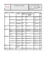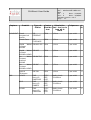
1
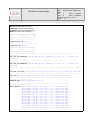
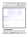
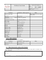
Centre de Gestion et de Traitement de Données Ref. : 0605004-NT-UDEV-V01-R06 Ed. : 1 Date : 11/04/06 Rev. : 6 Date : 31/08/09 Software version : 0.6.5 Number of pages : 30 CALXTRACT project : extraction of multisensors data in coincidence with CALIPSO CALXtract User Guide Name Date Prepared by Nicolas PASCAL James MANLEY ICARE/CGTD/UDEV Approved by For Application 31/08/09 Signature CALXtract User Guide Ref. : 0605004-NT-UDEV-V01R06 Ed. : 1 Date : 11/04/06 Rev. : 6 Date : 31/08/09 Software version : 0.6.5 Page : 2 MODIFICATIONS Edition Revision Date Revision Purpose 1 0 11/04/06 Creation 1 1 31/05/07 - The “philosophy” of the project has also been changed. At the beginning, calxtract was supposed to be a tool that can be run by any user. At this time, the focus points more on the products, which are built by the Icare exploitation team. Update to reflect changes in the calxtract software v0.3.3 : - New variables have been added in the caltrack products. This document includes those addings. The unit of the Optical Thickness variables has been set as none. In previous revision, it was set as “km” 1 2 27/07/07 - New variables have been added in the caltrack products. This document includes those addings. The MODIS Modis_Rad_#XX which were ignored and the PARASOL water vapour collum. - The generated file does not contain all the products as before. The new version generates scientific data files issued from only two different products. One of which is caliop 05kmclay. The second one is configured in the pcf configuration. 1 3 14/01/08 CALIOP Cloud is not the only possible sub track. It is possible to have a CALIOP level 1 sub track. 1 4 27/06/08 Insert new variables names. 1 6 31/08/09 Insert new variables names to reflect software updates CALXtract User Guide Ref. : 0605004-NT-UDEV-V01R06 Ed. : 1 Date : 11/04/06 Rev. : 6 Date : 31/08/09 Software version : 0.6.5 Page : 3 TABLE OF CONTENTS 1.ABBREVIATIONS AND GLOSSARY.........................................................................4 2.INTRODUCTION....................................................................................................5 3.INSTALLATION AND CONFIGURATION...................................................................6 3.1.Prerequisites applications........................................................................................6 3.2.Prerequisites libraries...............................................................................................6 3.3.Installation................................................................................................................6 4.USAGE..................................................................................................................7 4.1.Command line (low level usage)..............................................................................7 4.2.PCF file content........................................................................................................7 4.2.1.Product Sensor Filters.......................................................................................9 4.2.2.Main subtrack..................................................................................................10 4.3.Execution script (high level usage)........................................................................11 4.4.Input files................................................................................................................12 4.5.Output Product description.....................................................................................14 4.5.1.File format.......................................................................................................14 4.5.2.Variables.........................................................................................................15 5.REFERENCES......................................................................................................26 CALXtract User Guide Ref. : 0605004-NT-UDEV-V01R06 Ed. : 1 Date : 11/04/06 Rev. : 6 Date : 31/08/09 Software version : 0.6.5 Page : 4 1. ABBREVIATIONS AND GLOSSARY CALIOP Cloud Aerosol LIdar with Orthogonal Polarization CALIPSO CALTRACK CALXTRACT CVS DPC HDF IIR OMI PCF Cloud Aerosol LIdar Infrared Pathfinder Satellite Observations The name of the products that constructs the calxtract application The application that produces the caltrack files Concurrent Versions System Data Product Catalog Hierarchical Data Format Imaging Infrared Radiometer Ozone Monitoring Instrument Process Control File. It is an ascii file that contains all the parameters required for a run. Wide Field Camera WFC CALXtract User Guide Ref. : 0605004-NT-UDEV-V01R06 Ed. : 1 Date : 11/04/06 Rev. : 6 Date : 31/08/09 Software version : 0.6.5 Page : 5 2. INTRODUCTION This document focused mainly on the usage of the calxtract application. It also describes the content and the structure of the caltrack files, but if your need is only to use those files, you could prefer the document entitled “caltrack product catalog” that focuses more on the files produced by the calxtract software. This application does the extraction of parameters issued of different sensors (CALIOP, IIR, MODIS, PARASOL, CERES, ECMWF analysis, CLOUDSAT, and more in the future) under the CALIPSO's LIDAR subtrack or under the CALIOP level one subtrack. This software is mainly the result of a project that has been submitted to ICARE by : – Geneviève Sèze – Frédéric Parol – Jacques Pelon Ref. : 0605004-NT-UDEV-V01R06 Ed. : 1 Date : 11/04/06 Rev. : 6 Date : 31/08/09 Software version : 0.6.5 Page : 6 CALXtract User Guide 3. INSTALLATION AND CONFIGURATION 3.1. PREREQUISITES APPLICATIONS Name Version Description gcc >3.2.3 Needed to build the application autoconf >2.5 Needed to configure the build automake >1.6 Needed to build the application python [OPTIONAL] Needed to use the “high level” run script >2.4.1 3.2. PREREQUISITES LIBRARIES Libraries external to ICARE : Name HDF Version >=4.2r1 Description Used to read and write hdf files. Lien http://hdf.ncsa.uiuc.ed u/ ICARE libraries : Name Vers ion Description hdfcpp 1.1.0 This library encapsulates the hdf one to offer a higher level access in C++ filedata 0.2.0 Contains modules that permit to read the data of different types of sensors Lien 3.3. INSTALLATION 1) Download and extract the package, using the command tar xzf calxtract_X_X.tgz 2) Go in the extraction directory ( cd calxtract ), and use the usual tryptic : 3) ./configure prefix=<the_directory_where_you_want_to_install_the_software> REM : If you do not give a prefix argument to the configure script ( by typing only ./configure ) the software will be installed in the default install directory on your system ( /usr/bin or /usr/local/bin ), and will be accessible to all users on your system, but you will need the root access to execute the make install command. 4) make 5) make install CALXtract User Guide Ref. : 0605004-NT-UDEV-V01R06 Ed. : 1 Date : 11/04/06 Rev. : 6 Date : 31/08/09 Software version : 0.6.5 Page : 7 4. USAGE The basic principle of calxtract is to take as only argument a Process Control File (PCF) that contains all the parameters needed for the run (like the input files). But the drawback is that the user is responsible of the determination of the input files that contain some potential coincidences. So, to make the usage of calxtract easier, a high-level script in python, that encapsulates the build of the PCF file and the call to the executable has been developed. This method is the “easy to use” one, and should be better for users external to the Icare Team. 4.1. COMMAND LINE (LOW LEVEL USAGE) usage: <pathtotheinstalldirectory>/bin/calxtract <pcf_file> 4.2. PCF FILE CONTENT The file given as a command line argument is an ascii file that contains the following parameters. <path> must be replaced by a directory path. <product> designs the product to output in addition to CALIOP cloud 5km. ############################################ # # # CONFIGURATION FILE CALXTRACT # # # ############################################ ################################################# # CALXTRACT CONFIGURATION PARAMETERS (FIXED) ################################################# # Wether the output file must use the HDF compression or not UseHDFCompression=0 # Print out process information Verbose=1 # Overwrite the existing files Overwrite=1 # The radix that will start the output file name OutputFileRadix=calxtract_ # Name of the log file LogName=calxtract.log # Set the acceptable colocation frame between a CALIOP shot and a sensor measurement : if the distance between the position of a sensor's measurement and the position of a CALIOP shot is less than the ColocationTolerance set, those 2 measurements are considered as colocated. The ColocationTolerance value is in ° in a plane approximation CALXtract User Guide Ref. : 0605004-NT-UDEV-V01R06 Ed. : 1 Date : 11/04/06 Rev. : 6 Date : 31/08/09 Software version : 0.6.5 Page : 8 IIRColocationTolerance=0.005 MODISColocationTolerance=0.005 PARASOLColocationTolerance=0.05 CLOUDSATColocationTolerance=0.01 CERESColocationTolerance=0.1 ############################# ### OUTPUTS ### ############################# # The output file directory OutputDirectory=<path>/ # The log file output directory LogDirectory=<path>/ ############################ ### INPUTS ### ############################ # The input CAL_LID_L2_05kmCLay file. This file is the "master" one and is MANDATORY CAL_LID_L2_05kmCLay=(<path>/CAL_LID_L2_05kmCLayProvV110.20060828T1238 52ZD.hdf) # The input CAL_LID_L2_05kmALay file. Same half orbit than the CAL_LID_L2_05kmCLay one CAL_LID_L2_05kmALay=(<path>/CAL_LID_L2_05kmALayProvV110.20060828T1238 52ZD.hdf) # The input CAL_IIR_L2_Track file. Same half orbit than the CAL_LID_L2_05kmCLay one CAL_IIR_L2_Track=(<path>/CAL_IIR_L2_TrackProvV101.20060828T123852ZD.hdf) # The input CAL_LID_L1 file. Same half orbit than the CAL_LID_L2_05kmCLay one CAL_LID_L1=(<path>/CAL_LID_L1ProvV110.20060828T123852ZD.hdf) # The input PARASOL_RB2 file that has potential coincidences with the CAL_LID_L2_05kmCLay orbit PARASOL_RB2=(<path>/P3L2TRGB040110JL) # The MODIS_MYD06 files that have potential coincidences with the CAL_LID_L2_05kmCLay orbit MODIS_MYD06=(<path>/MYD06_L2.A2006240.1230.005.2006245102737.hdf, <path>/MYD06_L2.A2006240.1235.005.2006245103716.hdf, <path>/MYD06_L2.A2006240.1240.005.2006245110928.hdf, <path>/MYD06_L2.A2006240.1245.005.2006245105911.hdf, <path>/MYD06_L2.A2006240.1250.005.2006245105512.hdf, <path>/MYD06_L2.A2006240.1255.005.2006245105605.hdf, <path>/MYD06_L2.A2006240.1300.005.2006245110258.hdf, <path>/MYD06_L2.A2006240.1305.005.2006245103408.hdf, <path>/MYD06_L2.A2006240.1310.005.2006245104705.hdf, <path>/MYD06_L2.A2006240.1315.005.2006245110133.hdf, <path>/MYD06_L2.A2006240.1320.005.2006245105636.hdf, <path>/MYD06_L2.A2006240.1325.005.2006245112225.hdf, <path>/MYD06_L2.A2006240.1330.005.2006245104432.hdf, <path>/MYD06_L2.A2006240.1335.005.2006245104758.hdf) # The MODIS_MYD021KM files that have potential coincidences with the CALXtract User Guide Ref. : 0605004-NT-UDEV-V01R06 Ed. : 1 Date : 11/04/06 Rev. : 6 Date : 31/08/09 Software version : 0.6.5 Page : 9 CAL_LID_L2_05kmCLay orbit MODIS_MYD021KM=(<path>/MYD021KM.A2006240.1230.005.2006242023728.hdf, <path>/MYD021KM.A2006240.1235.005.2006242023628.hdf, <path>/MYD021KM.A2006240.1240.005.2006242025311.hdf, <path>/MYD021KM.A2006240.1245.005.2006242030306.hdf, <path>/MYD021KM.A2006240.1250.005.2006242030010.hdf, <path>/MYD021KM.A2006240.1255.005.2006242025504.hdf, <path>/MYD021KM.A2006240.1300.005.2006242030023.hdf, <path>/MYD021KM.A2006240.1305.005.2006242025804.hdf, <path>/MYD021KM.A2006240.1310.005.2006242031142.hdf, <path>/MYD021KM.A2006240.1315.005.2006242031511.hdf, <path>/MYD021KM.A2006240.1320.005.2006242033440.hdf, <path>/MYD021KM.A2006240.1325.005.2006242032723.hdf, <path>/MYD021KM.A2006240.1330.005.2006242032225.hdf, <path>/MYD021KM.A2006240.1335.005.2006242031317.hdf) # The CLOUDSAT files that have potential coincidences with the CAL_LID_L2_05kmCLay orbit CLOUDSAT_GEOPROF=(<path>/2006240121122_01779_CS_2B GEOPROF_GRANULE_P_R03_E02.hdf) CLOUDSAT_CLDCLASS=(<path>/2006240121122_01779_CS_2B CLDCLASS_GRANULE_P_R03_E02.hdf) # The GMAO meteo files GMAO_mis_x=(<path>/DAS.llk.asm.tsyn2d_mis_x.GEOS403.2006082800.2006082821.V01) GMAO_mis_p=(<path>/DAS.llk.asm.tsyn3d_mis_p.GEOS403.2006082800.2006082818.V01) ######################### ### SENSOR FILTERS ### ######################### #Select the product to extract in addition to caliop 05mclay (all others are filtered out) SensorFilters=<product> #Select the main sub track ether caliop_05kmclay or caliop_lid_l1 MainSubTrack=<main subtrack> 4.2.1. Product Sensor Filters The extraction of data take in account only two products, one of which is CALIOP cloud 5km. A filter must be set in order to ignore all other files. The syntax of this command is SensorFilters=<product>. The <product> token is one of the following: Product CALIOP aerosol 5km <product> token syntax caliop_05kmalay Misc CALXtract User Guide Product <product> token syntax CALIOP cloud 5km Misc Will be filtered to the output in any case. CALIOP L1 CLOUDSAT geometrical profile Ref. : 0605004-NT-UDEV-V01R06 Ed. : 1 Date : 11/04/06 Rev. : 6 Date : 31/08/09 Software version : 0.6.5 Page : 10 caliop_lid_l1 Cloud cloudsat_2b_geoprof CLOUDSAT Cloud Class cloudsat_2b_cldclass IIR L2 track iir_l2 MODIS L1B modis_myd021km MODIS cloud modis_myd06_l2 MYD04 MODIS_MYD04 MYD05 MODIS_MYD05 PARASOL BR2 parasol_rb2 PARASOL OC2 PARASOL_OC2 PARASOL LS2 PARASOL_LS2 PARASOL L1 PARASOL_L1 CERES CRS ceres OMI CLDO2 omi_cldo2 OMI NO2 omi_no2 OMI CLDRR omi_cldrr 4.2.2. Main subtrack Select the main subtrack and its variables. Product <product> token syntax CALIOP cloud 5km caliop_05kmclay CALIOP L1 caliop_lid_l1 Misc 4.3. EXECUTION SCRIPT (HIGH LEVEL USAGE) The another way to run the application is to use a python script which is situed in the “tools” directory. Usage: production_calxtract.py [options] Options: h, help show this help message and exit CALXtract User Guide Ref. : 0605004-NT-UDEV-V01R06 Ed. : 1 Date : 11/04/06 Rev. : 6 Date : 31/08/09 Software version : 0.6.5 Page : 11 t TIMESTAMP, timestamp=TIMESTAMP Timestamp of the master CAL_LID_L2 (or CAL_LID_L1) input file (format YYYYMMDDTHHMMSS) [MANDATORY] i INPUT_DIR, input_directory=INPUT_DIR Root of the CALIPSO data directory (default:/DATA/LIENS) o OUTPUT_DIR, output_directory=OUTPUT_DIR CALXTRACT output directory (default:/home/pascal/calxtract/data) c CALXTRACT_CFG_FILE, calxtract_cfg=CALXTRACT_CFG_FILE Path to the calxtract configuration file. It contains the calxtract "fixed" parameters v, verbose Print out processing informations x, overwrite Overwrite existing files k, keep_pcf_file Keep the output PCF file at the end of the script s MAIN_SUBTRACK, main_subtrack=MAIN_SUBTRACK Sets the main subtrack product, either caliop_05kmclay or caliop_l1. In most cases, the basic usage of this script is : python <pathtoinstalldir>/tools/production_calxtract.py t o <outputdirs root> where : • <path-to-install-dir> : the directory where calxtract has been installed • <calipso-orbit-timestamp> : the timestamp of a CALIPSO half-orbit start, having the format <YYYY-MM-DDTHH-MM-SS>, with YYYY, MM and DD are respectively the year (on 4 digits), the month (on 2 digits), and HH, MM, SS are the hours, minutes and seconds on 2 digits • <output-dirs-root> : must be an existing directory where you are allowed to write. The subdirectories <YYYY>/<YYYY_MM_DD> will be created to store the output files, with YYYY, MM and DD are respectively the year, the month and the day of the input CALIPSO half-orbit 4.4. INPUT FILES kind : o stands for optional, m stand for mandatory and u stands for unused. Ref. : 0605004-NT-UDEV-V01R06 Ed. : 1 Date : 11/04/06 Rev. : 6 Date : 31/08/09 Software version : 0.6.5 Page : 12 CALXtract User Guide Capteur CALIOP Produit Type de fichier CAL_LID_L1 cloud 5km ty pe 2 par orbite : m 1 jour + 1 nuit CAL_LID_L2 LARC _05kmCLay 5km 2 par orbite : m 1 jour + 1 nuit aerosol 5km CAL_LID_L2 LARC _05kmALay 5km 2 par orbite : o 1 jour + 1 nuit IIR L2 track CAL_IIR_L2_ LARC Track 1km*1km 2 par orbite : o 1 jour + 1 nuit MODIS L1B MYD021KM DAAC 21km*21km 1 par 5 min. o cloud MYD06_L2 DAAC 5km*5km 1 par 5 min. o MYD04 MODIS_MYD DAAC 04 1 par 5 min. o MYD05 MODIS_MYD DAAC 05 1 par 5 min. o cloud BR2 PARASOL_R ICARE B2 20km*20km 1 per orbit : o 1 jour OC2 PARASOL_O ICARE C2 20km*20km 1 per orbit : o 1 jour LS2 PARASOL_L S2 ICARE 20km*20km 1 per orbit : o 1 jour L1 PARASOL_L 1 ICARE 3km*3km 1 per orbit : o 1 jour CER_CRS_A qua-FM4MODIS LARC CERES CRS ECMWF analysis LARC Fréquence 333m PARASOL L1 Centre Résolution distribu (lat * lon) ou le teur long de la trace ECMWF 1km*1,25km 1 par heure u 1 par jour u CALXtract User Guide Capteur Produit CLOUDSAT Cloud geometrical profile Centre Résolution distribu (lat * lon) ou le teur long de la trace Fréquence ty pe 2BGEOPROF CIRA 1,1km 1 per orbit o 2BCLDCLASS CIRA 1,1km 1 per orbit o Liquid Water 2B-LWC-RO CIRA Content RADAR 1,1km 1 per orbit u Liquid Water 2B-LWC Content RADAR+LIDAR CIRA 1,1km 1 per orbit u Ice Water 2B-IWC-RO Content method RADAR CIRA 1,1km 1 per orbit u Ice Water 2B-IWC Content RADAR+LIDAR CIRA 1,1km 1 per orbit u Optical Thickness 2B-TAU CIRA 1,1km 1 per orbit u CLDO2 OMIAura_L2OMCLDO2 GSFC GES DISC - Nadir pixels 13x24 km 1 per orbit o NO2 OMIAura_L2OMNO2 GSFC GES DISC - Nadir pixels 13x24 km 1 per orbit o CLDRR OMIAura_L2OMCLDRR GSFC GES DISC - Nadir pixels 13x24 km 1 per orbit o Cloud Class OMI Type de fichier Ref. : 0605004-NT-UDEV-V01R06 Ed. : 1 Date : 11/04/06 Rev. : 6 Date : 31/08/09 Software version : 0.6.5 Page : 13 CALXtract User Guide Ref. : 0605004-NT-UDEV-V01R06 Ed. : 1 Date : 11/04/06 Rev. : 6 Date : 31/08/09 Software version : 0.6.5 Page : 14 4.5. OUTPUT PRODUCT DESCRIPTION 4.5.1. File format The output products will be in a HDF4 format, where each sds will contain the values of an physical variable along the CALIPSO subtrack. The output files will have a name that has been defined in the configuration file: For more details on the HDF4 format (link to the official page, reading tools and more), you may refer to the ICARE hdf description page : http://www.icare.univ-lille1.fr/ howto_hdf/ The output file will be organised like this : CALXtract User Guide Ref. : 0605004-NT-UDEV-V01R06 Ed. : 1 Date : 11/04/06 Rev. : 6 Date : 31/08/09 Software version : 0.6.5 Page : 15 4.5.2. Variables Here is an exhaustive list of the variables extracted from the input files. Not all variables are present, it depends on the products filtered. Name Description Unit Common to all caltrack unit products °north [Latitude Latitude 90,90] °east [Longitude Longitude 180,180] Time, using the TAI 93 Time seconds convention CALIOP L1 CAL_LID_L1_Total_Attenuat The Total Attenuated Backscatter km-1.sr-1 ed_Backscatter_532 signal at 532nm CAL_LID_L1_Perpendicular The perpendicular component of _Attenuated_Backscatter_ the attenuated backscatter at km-1.sr-1 532 532nm CAL_LID_L1_Attenuated_B The Attenuated Backscatter km-1.sr-1 ackscatter_1064 signal at 1064nm CAL_LID_L1_Molecular_Nu molecules.m The Molecular Number Density mber_Density ^-3 The Temperature for each meteo CAL_LID_L1_Temperature °C level The Pressure for each meteo CAL_LID_L1_Pressure mb level CAL_LID_L1_Ozone_Numbe molecules.m The Ozone Number Density r_Density ^-3 CAL_LID_L1_Relative_Humi The relative humidity for each % dity meteo level CAL_LID_L1_Land_Water_M The Land Water Mask unitless ask CAL_LID_L1_Tropopause_H The height of the tropopause Km eight CAL_LID_L1_Tropopause_T The temperature of the °C emperature tropopause PARASOL L1 Index [i_row,icol] of the coincident Pixel in the input P3L1_Input_Index unitless product. See in the file attribute to know which is this file Type float32 float32 float64 float32[583] float32[583] float32[583] float32[33] float32[33] float32[33] float32[33] float32[33] int8 float32 float32 int16[2] CALXtract User Guide Name P3L1_Number_Available_Vi ewing_Direction P3L1_Solar_Azimuth_Angle P3L1_Pixel_Quality_Index P3L1_Solar_Zenith_Angle P3L1_View_Zenith_Angle_6 70P2 P3L1_Relative_Azimuth_An gle_670P2 P3L1_Delta_Thetav_Cosphi P3L1_Delta_Thetav_Sinphi P3L1_Normalized_Radianc e_443NP P3L1_Normalized_Radianc e_490P P3L1_Normalized_Radianc e_1020NP P3L1_Normalized_Radianc e_565NP P3L1_Normalized_Radianc e_670P P3L1_Normalized_Radianc e_763NP P3L1_Normalized_Radianc e_765NP P3L1_Normalized_Radianc e_865P P3L1_Normalized_Radianc e_910NP Ref. : 0605004-NT-UDEV-V01R06 Ed. : 1 Date : 11/04/06 Rev. : 6 Date : 31/08/09 Software version : 0.6.5 Page : 16 Description Number of available viewing directions Ndir in the following 1<=id<=Ndir Solar Azimuth Angle Pixel Data Quality Index for each direction. Also known as DQX Solar Zenith Angle for each direction View Zenith Angle for filter 670P2, for each direction Relative Azimuth Angle for filter 670P2, for each direction Relative variation of viewing geometry between the filters, for each direction. See the appendix C of the PARASOL Level-1 Product Data Format and User Manual for details Relative variation of viewing geometry between the filters, for each direction. See the appendix C of the PARASOL Level-1 Product Data Format and User Manual for details Normalized Radiance for Channel 443NP, for each direction Normalized Radiance for Channel 490P, for each direction Normalized Radiance for Channel 1020NP, for each direction Normalized Radiance for Channel 565NP, for each direction Normalized Radiance for Channel 670P, for each direction Normalized Radiance for Channel 763NP, for each direction Normalized Radiance for Channel 765NP, for each direction Normalized Radiance for Channel 865P, for each direction Normalized Radiance for Channel 910NP, for each direction Unit Type unitless uint8 ° uint8 unitless uint16 ° uint16 ° uint16[16] ° uint16[16] ° int8[16] ° int8[16] unitless int16[16] unitless int16[16] unitless int16[16] unitless int16[16] unitless int16[16] unitless int16[16] unitless int16[16] unitless int16[16] unitless int16[16] CALXtract User Guide Name P3L1_Q_Stokes_490P P3L1_Q_Stokes_670P P3L1_Q_Stokes_865P P3L1_U_Stokes_490P P3L1_U_Stokes_670P P3L1_U_Stokes_865P MYD021KM_Input_File_Ind ex MYD021KM_Input_Pixel_In dex MYD021KM_EV_250_Aggr1 km_RefSB_Band1 MYD021KM_EV_250_Aggr1 km_RefSB_Band2 MYD021KM_EV_500_Aggr1 km_RefSB_Band3 MYD021KM_EV_500_Aggr1 km_RefSB_Band4 Ref. : 0605004-NT-UDEV-V01R06 Ed. : 1 Date : 11/04/06 Rev. : 6 Date : 31/08/09 Software version : 0.6.5 Page : 17 Description Second component of Stokes vector (Q) for Channel 490P, for each direction Second component of Stokes vector (Q) for Channel 670P, for each direction Second component of Stokes vector (Q) for Channel 865P, for each direction Third component of Stokes vector (U) for Channel 490P, for each direction Third component of Stokes vector (U) for Channel 670P, for each direction Third component of Stokes vector (U) for Channel 865P, for each direction MODIS MYD021KM Index of the input file where the coincidence has been found. See in the file attributes to see the list of files Index [i_row,icol] of the coincident Pixel in the input granule Earth View 250M Aggregated 1km Reflective Solar Bands Scaled Integers of channel n°1 (0.645µm) Earth View 250M Aggregated 1km Reflective Solar Bands Scaled Integers of channel n°2 (0.865µm) Earth View 500M Aggregated 1km Reflective Solar Bands Scaled Integers of channel n°3 (0.469µm) Earth View 500M Aggregated 1km Reflective Solar Bands Scaled Integers of channel n°4 (0.555µm) Unit Type unitless int16[16] unitless int16[16] unitless int16[16] unitless int16[16] unitless int16[16] unitless int16[16] unitless int16[2] unitless int16 W/m²/µm/sr uint16 W/m²/µm/sr uint16 W/m²/µm/sr uint16 W/m²/µm/sr uint16 CALXtract User Guide Name Ref. : 0605004-NT-UDEV-V01R06 Ed. : 1 Date : 11/04/06 Rev. : 6 Date : 31/08/09 Software version : 0.6.5 Page : 18 Description Earth View 500M Aggregated MYD021KM_EV_500_Aggr1 1km Reflective Solar Bands km_RefSB_Band5 Scaled Integers of channel n°5 (1.240µm) Earth View 500M Aggregated MYD021KM_EV_500_Aggr1 1km Reflective Solar Bands km_RefSB_Band6 Scaled Integers of channel n°6 (1.640µm) Earth View 500M Aggregated MYD021KM_EV_500_Aggr1 1km Reflective Solar Bands km_RefSB_Band7 Scaled Integers of channel n°7 (2.130µm) Earth View 1KM Reflective Solar MYD021KM_EV_1KM_RefSB Bands Scaled Integers of channel _Band8 n°8 (0.4125µm) Earth View 1KM Reflective Solar MYD021KM_EV_1KM_RefSB Bands Scaled Integers of channel _Band9 n°9 (0.443µm) Earth View 1KM Reflective Solar MYD021KM_EV_1KM_RefSB Bands Scaled Integers of channel _Band10 n°10 (0.488µm) Earth View 1KM Reflective Solar MYD021KM_EV_1KM_RefSB Bands Scaled Integers of channel _Band11 n°11 (0.541µm) Earth View 1KM Reflective Solar MYD021KM_EV_1KM_RefSB Bands Scaled Integers of channel _Band12 n°12 (0.551µm) Earth View 1KM Reflective Solar MYD021KM_EV_1KM_RefSB Bands Scaled Integers of channel _Band13LO n°13LO (0.667µm) Earth View 1KM Reflective Solar MYD021KM_EV_1KM_RefSB Bands Scaled Integers of channel _Band13HI n°13HI (0.667µm) Earth View 1KM Reflective Solar MYD021KM_EV_1KM_RefSB Bands Scaled Integers of channel _Band14LO n°14LO (0.678µm) Earth View 1KM Reflective Solar MYD021KM_EV_1KM_RefSB Bands Scaled Integers of channel _Band14HI n°14HI (0.678µm) Earth View 1KM Reflective Solar MYD021KM_EV_1KM_RefSB Bands Scaled Integers of channel _Band15 n°15 (0.748µm) Unit Type W/m²/µm/sr uint16 W/m²/µm/sr uint16 W/m²/µm/sr uint16 W/m²/µm/sr uint16 W/m²/µm/sr uint16 W/m²/µm/sr uint16 W/m²/µm/sr uint16 W/m²/µm/sr uint16 W/m²/µm/sr uint16 W/m²/µm/sr uint16 W/m²/µm/sr uint16 W/m²/µm/sr uint16 W/m²/µm/sr uint16 CALXtract User Guide Name Ref. : 0605004-NT-UDEV-V01R06 Ed. : 1 Date : 11/04/06 Rev. : 6 Date : 31/08/09 Software version : 0.6.5 Page : 19 Description Earth View 1KM Reflective Solar MYD021KM_EV_1KM_RefSB Bands Scaled Integers of channel _Band16 n°16 (1.3005µm) Earth View 1KM Reflective Solar MYD021KM_EV_1KM_RefSB Bands Scaled Integers of channel _Band17 n°17 (0.905µm) Earth View 1KM Reflective Solar MYD021KM_EV_1KM_RefSB Bands Scaled Integers of channel _Band18 n°18 (0.936µm) Earth View 1KM Reflective Solar MYD021KM_EV_1KM_RefSB Bands Scaled Integers of channel _Band19 n°19 (0.940µm) Earth View 1KM Reflective Solar MYD021KM_EV_1KM_RefSB Bands Scaled Integers of channel _Band26 n°26 (1.375µm) Earth View 1KM Emissive Bands MYD021KM_EV_1KM_Emiss Scaled Integers of channel n°20 ive_Band20 (3.750µm) Earth View 1KM Emissive Bands MYD021KM_EV_1KM_Emiss Scaled Integers of channel n°21 ive_Band21 (3.959µm) Earth View 1KM Emissive Bands MYD021KM_EV_1KM_Emiss Scaled Integers of channel n°22 ive_Band22 (3.959µm) Earth View 1KM Emissive Bands MYD021KM_EV_1KM_Emiss Scaled Integers of channel n°23 ive_Band23 (4.050µm) Earth View 1KM Emissive Bands MYD021KM_EV_1KM_Emiss Scaled Integers of channel n°24 ive_Band24 (4.465µm) Earth View 1KM Emissive Bands MYD021KM_EV_1KM_Emiss Scaled Integers of channel n°25 ive_Band25 (4.515µm) Earth View 1KM Emissive Bands MYD021KM_EV_1KM_Emiss Scaled Integers of channel n°27 ive_Band27 (6.715µm) Earth View 1KM Emissive Bands MYD021KM_EV_1KM_Emiss Scaled Integers of channel n°28 ive_Band28 (7.325µm) Earth View 1KM Emissive Bands MYD021KM_EV_1KM_Emiss Scaled Integers of channel n°29 ive_Band29 (8.550µm) Unit Type W/m²/µm/sr uint16 W/m²/µm/sr uint16 W/m²/µm/sr uint16 W/m²/µm/sr uint16 W/m²/µm/sr uint16 W/m²/µm/sr uint16 W/m²/µm/sr uint16 W/m²/µm/sr uint16 W/m²/µm/sr uint16 W/m²/µm/sr uint16 W/m²/µm/sr uint16 W/m²/µm/sr uint16 W/m²/µm/sr uint16 W/m²/µm/sr uint16 CALXtract User Guide Name MYD021KM_EV_1KM_Emiss ive_Band30 MYD021KM_EV_1KM_Emiss ive_Band31 MYD021KM_EV_1KM_Emiss ive_Band32 MYD021KM_EV_1KM_Emiss ive_Band33 MYD021KM_EV_1KM_Emiss ive_Band34 MYD021KM_EV_1KM_Emiss ive_Band35 MYD021KM_EV_1KM_Emiss ive_Band36 CS_1B_CPR_Input_File_Ind ex Ref. : 0605004-NT-UDEV-V01R06 Ed. : 1 Date : 11/04/06 Rev. : 6 Date : 31/08/09 Software version : 0.6.5 Page : 20 Description Earth View 1KM Emissive Bands Scaled Integers of channel n°30 (9.730µm) Earth View 1KM Emissive Bands Scaled Integers of channel n°31 (11.030µm) Earth View 1KM Emissive Bands Scaled Integers of channel n°32 (12.020µm) Earth View 1KM Emissive Bands Scaled Integers of channel n°33 (13.335µm) Earth View 1KM Emissive Bands Scaled Integers of channel n°34 (13.635µm) Earth View 1KM Emissive Bands Scaled Integers of channel n°35 (13.935µm) Earth View 1KM Emissive Bands Scaled Integers of channel n°36 (14.235µm) CLOUDSAT 1B-CPR Index of the input file where the coincidence has been found. See in the file attributes to see the list of files CS_1B_CPR_Input_Profile_I Index of the coincident profile ndex CS_1B_CPR_Range_to_inte Range to the CPR boresight rcept intercept with the geoid Range to first bin is the distance CS_1B_CPR_Range_to_first between the satellite and the _bin starting bin number of the ray in meters Echo Power is the calibrated CS_1B_CPR_ReceivedEcho range gate power in watts, made Powers in-flight and averaged CALIOP L2 05kmCLay CAL_LID_L2_05KMCLAY_DE Surface Elevation read from the M_Surface_Elevation Digital Elevation Model (DEM) CAL_LID_L2_05KMCLAY_Lid Lidar Echo Ground Elevation ar_Surface_Elevation Unit Type W/m²/µm/sr uint16 W/m²/µm/sr uint16 W/m²/µm/sr uint16 W/m²/µm/sr uint16 W/m²/µm/sr uint16 W/m²/µm/sr uint16 W/m²/µm/sr uint16 unitless int16 unitless int16 Km float32 m float32 W float32[125] Km float32 Km float32 CALXtract User Guide Name CAL_LID_L2_05KMCLAY_Su rface_Elevation_Detection_ Frequency CAL_LID_L2_05KMCLAY_Nu mber_Layers_Found CAL_LID_L2_05KMCLAY_La yer_Top_Altitude CAL_LID_L2_05KMCLAY_La yer_Base_Altitude CAL_LID_L2_05KMCLAY_Fe ature_Classification_Flags CAL_LID_L2_05KMCLAY_Fe ature_Optical_Depth_532 Ref. : 0605004-NT-UDEV-V01R06 Ed. : 1 Date : 11/04/06 Rev. : 6 Date : 31/08/09 Software version : 0.6.5 Page : 21 Description Unit Type Lidar Echo Surface Detection Frequency unitless uint8 Number of Cloud Layers Found Layer int8 Cloud Layer Top Altitude Km float32[10] Cloud Layer Base Altitude Km float32[10] Cloud Layer feature classification unitless flags Cloud Layer Optical Depth at unitless 532nm Cloud Layer Thermodynamic Phase, as read in the feature classification flags CAL_LID_L2_05KMCLAY_Ph 0=undefined unitless ase 1=ice 2=water 3=mixed CALIOP L2 05kmALay CAL_LID_L2_05KMALAY_Nu Number of Aerosol Layers Found Layer mber_Layers_Found CAL_LID_L2_05KMALAY_La Aerosol Layer Top Altitude Km yer_Top_Altitude CAL_LID_L2_05KMALAY_La Aerosol Layer Base Altitude Km yer_Base_Altitude CAL_LID_L2_05KMALAY_Fe Aerosol layer feature unitless ature_Classification_Flags classification flags CAL_LID_L2_05KMALAY_La Aerosol Layer Top Temperature °C yer_Top_Temperature CAL_LID_L2_05KMALAY_La Aerosol Layer Base Temperature °C yer_Base_Temperature CAL_LID_L2_05KMALAY_La Aerosol Layer Top Pressure hPa yer_Top_Pressure CAL_LID_L2_05KMALAY_La Aerosol Layer Base Pressure hPa yer_Base_Pressure CAL_LID_L2_05KMALAY_Fe Aerosol Layer Optical Depth at unitless ature_Optical_Depth_532 532nm CALIPSO IIR L2 Track CAL_IIR_L2_Brightness_Te Brightness Temperature at 12µm K mperature_12_05 uint16[10] float32[10] uint8 int8 float32[8] float32[8] uint16[8] float32[8] float32[8] float32[8] float32[8] float32[8] float32 CALXtract User Guide Ref. : 0605004-NT-UDEV-V01R06 Ed. : 1 Date : 11/04/06 Rev. : 6 Date : 31/08/09 Software version : 0.6.5 Page : 22 Name Description CAL_IIR_L2_Brightness_Te Brightness Temperature at mperature_10_60 10,6µm CAL_IIR_L2_Brightness_Te Brightness Temperature at mperature_08_65 8,65µm CAL_IIR_L2_Effective_Parti Size of the Particles at 5km cle_Size Resolution CAL_IIR_L2_Particle_Shape Particle Shape Index _Index CAL_IIR_L2_Ice_Water_Path Ice Water Path PARASOL OC2 Index [i_row,icol] of the coincident Pixel in the input P3L2TOGC_Input_Index product. See in the file attribute to know which is this file P3L2TOGC_Pixel_Confiden Pixel confidence data indicator ce_Data Quality of the fit : IQ = (1 P3L2TOGC_Fit_Quality DLmoy/2E-3) > 0 P3L2TOGC_Solar_Zenith_A Solar Zenith Angle ngle P3L2TOGC_Aerosol_OD_86 Aerosol Optical Thickness at 5 865nm P3L2TOGC_Aerosol_OD_67 Aerosol Optical Thickness at 0 670nm P3L2TOGC_Aerosol_Angstr Aerosol Angström Coefficient om_Coefficient P3L2TOGC_Single_Scatteri Single Scattering Albedo at ng_Albedo_865 865nm P3L2TOGC_Aerosol_Scatte Aerosol Scattering Asymmetry ring_Asymmetry_Factor Factor P3L2TOGC_Aerosol_Index Aerosol Index P3L2TOGC_Aerosol_Effecti Aerosol Effective Radius ve_Radius P3L2TOGC_Fine_Mode_Effe Fine Mode Effective Radius ctive_Radius P3L2TOGC_Large_Mode_Ef Large Mode Effective Radius fective_Radius P3L2TOGC_Fine_Mode_OD Fine Mode Optical Thickness at _865 865nm P3L2TOGC_Fine_Mode_OD Fine Mode Optical Thickness at _670 670nm Unit Type K float32 K float32 µm float32 unitless int8 % float32 unitless int16[2] unitless uint32 unitless uint8 ° uint16 unitless uint16 unitless uint16 unitless uint16 unitless uint8 unitless uint8 unitless uint16 µm uint8 µm uint8 µm uint8 unitless uint16 unitless uint16 CALXtract User Guide Name P3L2TOGC_Fine_Mode_Ang strom_Exponent P3L2TOGC_Spherical_Coar se_Mode_OD_865 P3L2TOGC_Non_Spherical_ Coarse_Mode_OD_865 P3L2TOGC_Relative_Contri b_Non_Spherical_Part_Coar se_Mode P3L2TOGC_Refractive_Inde x_Fine_Mode P3L2TOGC_Refractive_Inde x_Coarse_Mode P3L2TOGC_Log_Backscatte ring_Coefficient_565 P3L2TOGC_Log_Backscatte ring_Coefficient_1020 P3L2TLGC_Input_Index P3L2TLGC_Land_Water_Ind icator P3L2TLGC_Pixel_Confidenc e_Data P3L2TLGC_Aerosol_OD_86 5 P3L2TLGC_Aerosol_Model_ Refractive_Index P3L2TLGC_Aerosol_Model_ Angstrom_Coefficient P3L2TLGC_Aerosol_Index P3L2TLGC_Fixed_Model_O D_865 P3L2TLGC_Quality_Index_V iewing_Geometry Ref. : 0605004-NT-UDEV-V01R06 Ed. : 1 Date : 11/04/06 Rev. : 6 Date : 31/08/09 Software version : 0.6.5 Page : 23 Description Fine Mode Angström Exponent Optical Thickness of Spherical Coarse Mode at 865nm Optical Thickness of NonSpherical Coarse Mode at 865nm Relative Contribution of NonSpherical Particles in Coarse Mode Refractive Index of Fine Mode, only for Fine Mode Optical Thickness at 865nm > 0.02 Refractive Index of Coarse Mode, only for Spherical Coarse Mode at 865nm > 0.02 Logarithm of the Backscattering Coefficient at 565nm Logarithm of the Backscattering Coefficient at 1020nm PARASOL LS2 Index [i_row,icol] of the coincident Pixel in the input product. See in the file attribute to know which is this file Land (100), Water (0) or Mixed (50) Indicator Pixel confidence data indicator Aerosol Optical Thickness at 865nm Aerosol Model Refractive Index (Real Part) Aerosol Model Angström Coefficient Aerosol Index Fixed Model Optical Thickness at 865nm Quality Index for Viewing Geometry (0:bad ; 1:excellent) Quality Index for Polarized P3L2TLGC_Quality_Index_P Reflectance Fit (0:bad ; olarized_Reflectance_Fit 1:excellent) Unit Type unitless uint16 unitless uint16 unitless uint16 unitless uint8 unitless uint8 unitless uint8 unitless uint16 unitless uint16 unitless int16[2] unitless uint8 unitless uint32 unitless uint16 unitless uint8 unitless uint8 unitless uint16 unitless uint16 unitless uint16 unitless uint8 CALXtract User Guide Name P3L2TRGB_Input_Index P3L2TRGB_Cloud_Cover Ref. : 0605004-NT-UDEV-V01R06 Ed. : 1 Date : 11/04/06 Rev. : 6 Date : 31/08/09 Software version : 0.6.5 Page : 24 Description PARASOL RB2 Index [i_row,icol] of the coincident Pixel in the input product. See in the file attribute to know which is this file cloud cover, defined as the number of cloudy pixels divided by the total number of pixels Unit Type unitless int16[2] unitless uint8 P3L2TRGB_Directional_Clo Directional Apparent Cloud Cover unitless ud_Cover mean cloud oxygen pressure P3L2TRGB_Cloud_Oxygen_ (expected to be close of the cloud hPa Pressure middle pressure) P3L2TRGB_Cloud_Oxygen_ Angular Standard Deviation of the hPa Pressure_Angular_Stddev Cloud Oxygen Pressure mean cloud Rayleigh pressure P3L2TRGB_Cloud_Rayleigh (expected to be close of the cloud hPa _Pressure top pressure) P3L2TRGB_Cloud_Rayleigh Angular Standard Deviation of the hPa _Pressure_Angular_Stddev Cloud Rayleigh Pressure linear mean cloud optical P3L2TRGB_Cloud_Optical_ thickness (670 nm over land and unitless Thickness 865 nm over ocean) Relative Spatial Standard P3L2TRGB_Cloud_Optical_ Deviation of Cloud Optical % Thickness_Stddev Thickness P3L2TRGB_Cloud_Phase Cloud Phase unitless P3L2TRGB_Water_Vapor_C Water Vapor Column, based on g/cm² olumn clear pixel measurements Mean albedo at 670 nm over land P3L2TRGB_Mean_Albedo unitless and 865 nm over ocean, aka avis Relative spatial standard P3L2TRGB_Albedo_Spatial_ deviation of the albedos (based % Stddev on the direction-means), aka rsd_avis Relative angular standard P3L2TRGB_Albedo_Angular deviation of the albedos (based % _Stddev on the spatial-means), aka rad_avis uint8 uint8 uint8 uint8 uint8 uint16 uint8 uint8 uint8 uint16 uint8 uint8 CALXtract User Guide Ref. : 0605004-NT-UDEV-V01R06 Ed. : 1 Date : 11/04/06 Rev. : 6 Date : 31/08/09 Software version : 0.6.5 Page : 25 Name Description Surface type indicator, aka tmc [0] : 100% water P3L2TRGB_Surface_Type_I [10] : > 90% water ndex [50] : mixed [90] : > 90% Land [100] : 100% Land P3L2TRGB_Cos_Solar_Zeni Cosine of the Solar Zenith Angle th_Angle for central pixel, aka mus Relative Angular standard P3L2TRGB_Scene_Albedo_ deviation of the Scene Albedo, Angular_Stddev aka rad_ascvis Homogeneity coefficient of the optical thickness : τ*/ τ where τ is the scene mean P3L2TRGB_Optical_Thickne optical thickness, and τ* is the ss_Homegeneity_Coef optical thickness derived from the scene mean reflectance, aka eps_tau MODIS MYD04_L2 Index of the input file where the coincidence has been found. See MYD04_Input_File_Index in the file attributes to see the list of files Index [i_row,icol] of the MYD04_Input_Pixel_Index coincident Pixel in the input granule Aerosol Optical Thickness at 0.55 MYD04_Optical_Depth_Lan micron for both ocean (best) and d_And_Ocean land (corrected) with best quality data(Quality flag=3) MYD04_Optical_Depth_Rati Ratio of small mode optical depth o_Small_Land_And_Ocean at 0.55 micron Aerosol Optical Thickness at 7 MYD04_Effective_Optical_ bands for best solution for 0.47, Depth_Best_Ocean 0.55, 0.66, 0.86, 1.24, 1.63, 2.13 um MYD04_Angstrom_Expone Angstrom Exponent for 0.55 and nt_1_Ocean 0.86 micron MODIS MYD05_L2 Index of the input file where the coincidence has been found. See MYD05_Input_File_Index in the file attributes to see the list of files Unit % Type uint8 unitless uint8 % uint8 unitless uint8 unitless int16 unitless int16 unitless int16 unitless int16 unitless int16[7] unitless int16[2] unitless int16[2] CALXtract User Guide Ref. : 0605004-NT-UDEV-V01R06 Ed. : 1 Date : 11/04/06 Rev. : 6 Date : 31/08/09 Software version : 0.6.5 Page : 26 Name Description Index [i_row,icol] of the MYD05_Input_Pixel_Index coincident Pixel in the input granule MYD05_Water_Vapor_Near Total Column Precipitable Water _Infrared Vapor - Near Infrared Retrieval MYD05_Water_Vapor_Infra Total Column Precipitable Water red Vapor - Infrared Retrieval Aerosol Correction Factor for MYD05_Water_Vapor_Corr Water Vapor - Near Infrared ection_Factors Retrieval MYD05_Quality_Assurance Run time QA flags _Infrared MYD05_Quality_Assurance Run time QA flags _Near_Infrared MYD05_Cloud_Mask MODIS Cloud Mask, First Byte MODIS MYD06_L2 Index of the input file where the coincidence has been found. See MYD06_Input_File_Index in the file attributes to see the list of files Index [i_row,icol] of the MYD06_Input_Pixel_Index coincident Pixel in the input granule MYD06_Brightness_Tempe Brightness Temperature of rature_Band_29 Channel n°29 (8.550µm) MYD06_Brightness_Tempe Brightness Temperature of rature_Band_31 Channel n°31 (11.030µm) MYD06_Brightness_Tempe Brightness Temperature of rature_Band_32 Channel n°32. (12.020µm) MYD06_Brightness_Tempe Brightness Temperature of rature_Band_33 Channel n°33 (13.335µm) MYD06_Brightness_Tempe Brightness Temperature of rature_Band_34 Channel n°34 (13.635µm) MYD06_Brightness_Tempe Brightness Temperature of rature_Band_35 Channel n°35 (13.935µm) MYD06_Brightness_Tempe Brightness Temperature of rature_Band_36 Channel n°36 (14.235µm) Cloud Optical Thickness twoMYD06_Cloud_Optical_Thic channel retrieval using band 7 kness and either band 1, 2, or 5 Unit Type unitless int16 cm int16 cm int16 unitless int16 unitless int8[5] unitless int8 unitless int8 unitless int16[2] unitless int16 K int16 K int16 K int16 K int16 K int16 K int16 K int16 unitless int16 CALXtract User Guide Name Ref. : 0605004-NT-UDEV-V01R06 Ed. : 1 Date : 11/04/06 Rev. : 6 Date : 31/08/09 Software version : 0.6.5 Page : 27 Description Unit Column Water Path two-band MYD06_Cloud_Water_Path retrieval using band 7 and either g/m² band 1, 2, or 5 MYD06_Cloud_Top_Pressur Cloud Top Pressure hPa e Number of Clear Pixels (of 1km) MYD06_Number_Clear_Pix at 5km resolution. Read in the nb_pixels el Cloud_Mask_1km dataset Number of Cloudy Pixels (of 1km) MYD06_Number_Cloudy_Pi at 5km resolution. Read in the nb_pixels xel Cloud_Mask_1km dataset Number of Indetermined Pixels MYD06_Number_Indetermi (of 1km) at 5km resolution. Read nb_pixels ned_Pixel in the Cloud_Mask_1km dataset Cloud Particle Effective Radius two-channel retrieval using band MYD06_Cloud_Effective_Ra 7 and either band 1, 2, or 5 µm dius (specified in Quality_Assurance_1km) Cloud Phase Determination Used MYD06_Cloud_Phase_Optic in Optical Thickness/Effective al_Properties Radius Retrieval Cloud Multi Layer Identification MYD06_Cloud_Multi_Layer_ From MODIS Shortwave Flag Observations MYD06_Cloud_Fraction Cloud Fraction MODIS Cloud Mask at 5km, First MYD06_Cloud_Mask_5km Byte MODIS Cloud Mask at 1km, L2 MYD06_Cloud_Mask_1km MOD06 QA Plan MYD06_Quality_Assurance Quality Assurance at 5x5 _5km Resolution MYD06_Quality_Assurance Quality Assurance at 1x1 _1km Resolution CLOUDSAT 2B-GEOPROF Index of the input file where the CS_2B_GEOPROF_Input_Fil coincidence has been found. See unitless e_Index in the file attributes to see the list of files CS_2B_GEOPROF_Input_Pr Index of the coincident profile unitless ofile_Index Type int16 int16 int8 int8 int8 int8 int16 int16 int8 int8 int8 int8 int8 int16 int16 CALXtract User Guide Ref. : 0605004-NT-UDEV-V01R06 Ed. : 1 Date : 11/04/06 Rev. : 6 Date : 31/08/09 Software version : 0.6.5 Page : 28 Name Description Height of range bin in Reflectivity/Cloud Mask above CS_2B_GEOPROF_Height reference surface (~ mean sea level) Each CPR resolution volume is assigned 1 bit mask value: 0 = No cloud detected 1 = likely bad data 5 = likely ground clutter CS_2B_GEOPROF_CPR_Clo 5-10 = week detection found ud_mask using along track integration 20 to 40 = Cloud detected .. increasing values represents clouds with lower chance of a being a false detection CS_2B_GEOPROF_Gaseous Gaseous attenuation _Attenuation Radar reflectivity factor Ze is CS_2B_GEOPROF_Radar_R calculated with the echo power eflectivity and other input data as described in Li and Durden (2001) CLOUDSAT 2B-CLDCLASS Index of the input file where the CS_2B_CLDCLASS_Input_Fil coincidence has been found. See e_Index in the file attributes to see the list of files CS_2B_CLDCLASS_Input_Pr Index of the coincident profile ofile_Index Height of range bin in Reflectivity/Cloud Mask above CS_2B_CLDCLASS_Height reference surface (~ mean sea level) Algorithm outputs (cloud type CS_2B_CLDCLASS_cloud_s and different flags) are combined cenario into a 16 bit cloud_scenario OMI-CLDO2 Effective cloud fraction clipped omi_cldo2_cloud_fraction between 0.0 and 1.0 omi_cldo2_cloud_pressure Effective cloud pressure OMI-NO2 omi_no2_cloud_fraction Effective cloud fraction omi_no2_cloud_pressure Effective cloud pressure Unit Type m int16[125] unitless int8[125] dBZe int16[125] dBZe int16[125] unitless int16 unitless int16 m int16[125] unitless int16[125] unitless float32 hPa int16 unitless hPa int16 int16 CALXtract User Guide Ref. : 0605004-NT-UDEV-V01R06 Ed. : 1 Date : 11/04/06 Rev. : 6 Date : 31/08/09 Software version : 0.6.5 Page : 29 Name Description omi_no2_ColumnAmountN NO2 tropospheric column density O2Trop omi_no2_ColumnAmountN Precision of the NO2 tropospheric O2TropStd column density OMI-CLDRR omi_cldrr_cloud_fraction Cloud Fraction for O3 omi_cldrr_cloud_pressure Cloud Pressure for O3 omi_cldrr_rad_cloud_fracti Radiative Cloud Fraction on Unit Type molec/cm^2 float32 molec/cm^2 float32 unitless hPa float32 float32 unitless float32 The values used to represents absent or dummy ones (also called Fill Values) depend of the type of the variable. Type Fill Value float32 -inf float64 -inf int8 -128 uint8 255 CALXtract User Guide Ref. : 0605004-NT-UDEV-V01R06 Ed. : 1 Date : 11/04/06 Rev. : 6 Date : 31/08/09 Software version : 0.6.5 Page : 30 5. REFERENCES Title Versio n Link HDF 4 reference manual 4.2r1 http://hdf.ncsa.uiuc.edu/doc.html HDF 4 user guide 4.2r1 http://hdf.ncsa.uiuc.edu/doc.html CALIPSO DPC 3.0 http://eosweb.larc.nasa.gov/PRODOCS/calipso/DP C/ MODIS file specifications CERES DPC http://modisatmos.gsfc.nasa.gov/MOD06_L2/spec.html R4V1 http://earthwww.larc.nasa.gov/ceresdoc/DPC/DPC_current/D PC.html PARASOL Level 2 Product. Ed1Rev http://www-icare.univ-lille1.fr/fr/parasol.php Data Format and User 1 Manual Cloudsat Handbook Data OMI Data website Products description http://www.cloudsat.cira.colostate.edu/cloudsat_ documentation/ http://disc.sci.gsfc.nasa.gov/Aura/data-holdings/ OMI/