1
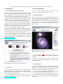
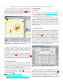
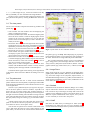
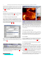
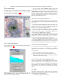
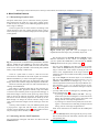
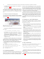
ALADIN User’s Manual
Daniel Egret1,2 , Franc¸ois Bonnarel1 , Pierre Fernique1 , Thomas Boch1 , Olivier Bienaym´e1
1
2
CDS, UMR 7550, Observatoire de Strasbourg, 11 rue de l’Universit´e, 67000 Strasbourg, France
present address: Observatoire de Paris
Email: [email protected]
February 16, 2004– Aladin Manual 2nd release – describing Aladin version 2.
Abstract. A LADIN is an interactive sky atlas developed and maintained by the Centre de Donn´ees astronomiques de Strasbourg
(CDS) for the identification of astronomical sources through visual analysis of reference sky images.
Contents
1
Introduction
1.1 The ALADIN interactive sky atlas . . . . . . .
1.2 The CDS . . . . . . . . . . . . . . . . . . . .
3
3
3
2
The user interfaces
2.1 Aladin previewer . . . . . . . . . . . . . . . .
2.2 Aladin applet . . . . . . . . . . . . . . . . . .
2.3 Aladin Standalone . . . . . . . . . . . . . . . .
3
3
3
4
Using Aladin
3.1 Access . . . . . . . . . . . . . . . . . . . . .
3.2 Getting started . . . . . . . . . . . . . . . . .
3.3 The view panels . . . . . . . . . . . . . . . .
3.4 The plane stack . . . . . . . . . . . . . . . .
3.4.1 Image Plane . . . . . . . . . . . . . .
3.4.2 Simbad . . . . . . . . . . . . . . . .
3.4.3 VizieR . . . . . . . . . . . . . . . .
3.4.4 NED . . . . . . . . . . . . . . . . .
3.4.5 Mission logs and Image Archives . .
3.4.6 Instrument Field of View . . . . . . .
3.4.7 My Data . . . . . . . . . . . . . . .
3.5 Learning more about the astronomical objects
3.5.1 Selecting objects . . . . . . . . . . .
3.5.2 The Measurement window . . . . . .
3.6 The tool bar . . . . . . . . . . . . . . . . . .
3.6.1 Properties . . . . . . . . . . . . . . .
3.6.2 Draw . . . . . . . . . . . . . . . . .
3.6.3 Text, Tags . . . . . . . . . . . . . . .
3.6.4 Distance (Dist) . . . . . . . . . . . .
3.6.5 RGB colour composition . . . . . . .
3.6.6 Contour plots . . . . . . . . . . . . .
3.6.7 Colour map (Histog.) . . . . . . . . .
3.6.8 Zoom and image manipulation . . . .
3.6.9 Scale and coordinate grid . . . . . . .
3.6.10 Cut-and-paste using the Pad window .
3.7 Help . . . . . . . . . . . . . . . . . . . . . .
4
4
4
5
5
5
5
5
6
6
6
6
6
6
7
7
7
7
7
7
7
8
8
8
8
8
8
3
.
.
.
.
.
.
.
.
.
.
.
.
.
.
.
.
.
.
.
.
.
.
.
.
.
.
4 More Detailed Features
4.1 Manipulating the plane stack . . . . . .
4.2 Interacting with the VizieR database . .
4.3 Shortcut commands for loading data . .
4.4 Coordinates manipulation . . . . . . . .
4.5 Using the SHIFT key for hidden features
4.6 URL command lines . . . . . . . . . .
.
.
.
.
.
.
5 Filters in Aladin
5.1 Introduction . . . . . . . . . . . . . .
5.2 Syntax . . . . . . . . . . . . . . . . .
5.2.1 Invocating columns . . . . . .
5.2.2 Comments . . . . . . . . . .
5.2.3 Arithmetic
expressions
UCDs/columns . . . . . . . .
5.2.4 Conditions . . . . . . . . . .
5.2.5 Constraints . . . . . . . . . .
5.2.6 Actions . . . . . . . . . . . .
5.2.7 Defining a color . . . . . . . .
5.2.8 Symbol shape . . . . . . . . .
5.3 Usage in Aladin . . . . . . . . . . . .
5.3.1 Creating a filter . . . . . . . .
5.3.2 Modifying a filter . . . . . . .
5.3.3 Syntax errors . . . . . . . . .
5.3.4 Activate/Deactivate a filter . .
5.3.5 Scope of a filter . . . . . . . .
5.3.6 Applying multiple filters . . .
5.3.7 Creating a filter in script mode
5.3.8 Miscellaneous . . . . . . . .
.
.
.
.
.
.
.
.
.
.
.
.
.
.
.
. . . .
. . . .
. . . .
. . . .
using
. . . .
. . . .
. . . .
. . . .
. . . .
. . . .
. . . .
. . . .
. . . .
. . . .
. . . .
. . . .
. . . .
. . . .
. . . .
12
12
13
13
13
13
14
14
14
14
14
14
15
15
15
.
.
.
.
.
.
.
.
.
.
.
.
.
.
15
15
15
16
16
16
16
16
6
The image database
6.1 Database summary . . . . .
6.2 DSS Images . . . . . . . . .
6.3 MAMA/CAI Images . . . .
6.4 2MASS near-infrared survey
6.5 The image server . . . . . .
6.6 Image astrometry . . . . . .
6.7 Image compression . . . . .
.
.
.
.
.
.
.
.
.
.
.
.
.
.
.
.
.
.
.
.
.
.
.
.
.
.
.
.
.
.
.
.
.
.
.
.
.
.
.
.
.
.
.
.
.
.
.
.
.
.
.
.
.
.
.
.
.
.
.
.
.
.
.
.
.
.
.
.
.
.
.
.
.
.
.
.
.
.
9
9
9
10
10
10
10
11
11
11
11
12
2
Daniel Egret, Franc¸ois Bonnarel, Pierre Fernique, Thomas Boch, Olivier Bienaym´e: ALADIN User’s Manual
7 The catalogue and survey server
7.1 VizieR . . . . . . . . . . . . . . . . . . . . . .
7.2 Archive previews . . . . . . . . . . . . . . . .
17
17
17
8 Specific features of the Stand-alone version
8.1 Starting the Stand-alone version . . . . . . .
8.1.1 The Java Virtual Machine . . . . . .
8.1.2 The AladinJava Stand-alone package
8.2 Loading personal files with Aladin Standalone
8.2.1 Local images . . . . . . . . . . . . .
8.2.2 Calibrating Images . . . . . . . . . .
8.2.3 Local Tables . . . . . . . . . . . . .
8.3 Saving and Printing . . . . . . . . . . . . . .
8.4 Defining additional servers . . . . . . . . . .
8.5 Script language . . . . . . . . . . . . . . . .
17
17
17
17
18
18
18
18
18
19
19
9
User feedback
.
.
.
.
.
.
.
.
.
.
20
10 Acknowledgements
20
A Backus Naur Form of filter syntax
21
Daniel Egret, Franc¸ois Bonnarel, Pierre Fernique, Thomas Boch, Olivier Bienaym´e: ALADIN User’s Manual
3
1. Introduction
2. The user interfaces
1.1. The ALADIN interactive sky atlas
A LADIN is currently available in three main modes: A LADIN
previewer; java applet; java stand-alone version.
A LADIN is an interactive sky atlas developed and maintained
by the Centre de Donn´ees astronomiques de Strasbourg (CDS)
for the identification of astronomical sources through visual
analysis of reference sky images (Bonnarel et al. 2000).
A LADIN fully benefits from the environment of CDS
databases and services (S IMBAD reference database, VizieR
catalogue service, etc.), and is designed as a multi-purpose service for use by the professional astronomical community.
A LADIN allows the user to visualize digitized images of
any part of the sky, to superimpose entries from the CDS astronomical catalogues and tables, and to interactively access
related data and information from S IMBAD, NED, VizieR, or
other archives for all known objects in the field.
A LADIN is particularly useful for multi-spectral crossidentifications of astronomical sources, observation preparation and quality control of new data sets (by comparison with
standard catalogues covering the same region of sky).
The A LADIN interactive atlas is available in three main
modes: a simple previewer, a java applet, and a java standalone application (to be downloaded by the user). A LADIN
is publicly accessible on the World-Wide Web at the address:
http://aladin.u-strasbg.fr/.
2.1. Aladin previewer
The A LADIN previewer is a pre-formatted image server providing a compressed image of fixed size, around a given object or position, either in full resolution (14.10 × 14.10 for the
DSS-I used as default reference atlas), or as a global plate view
(approximately 6◦ × 6◦ according to the survey). When an object name is given, its position is resolved through the S IMBAD
name resolver.
Fig. 2. Result page of A LADIN previewer for the galaxy M51.
The default image is from DSS-I.
The result page (Fig. 2) gives also access to the other survey images available, and to the full resolution FITS image for
download.
This is a direct and simple tool for sky visualization, without the interactive features (catalogue access, overlays...) of the
main Java version.
Fig. 1. Home page of A LADIN at the CDS Web site.
1.2. The CDS
The Centre de Donn´ees astronomiques de Strasbourg (CDS)
defines, develops, and maintains services to help astronomers
find the information they need from the very rapidly increasing
wealth of astronomical information.
A detailed description of the CDS on-line services can be
found, e.g., in Genova et al. (2000), or at the CDS web site:
http://cdsweb.u-strasbg.fr/.
2.2. Aladin applet
The Aladin Java applet is the primary public interface, supporting queries to the CDS image server, overlays from any catalogue or table available at CDS, or from S IMBAD and NED
databases, and access to a number of remote archives.
A LADIN applet is available directly through current Web
browsers (such as Netscape, Mozilla or IExplorer).
It allows the user to query images, catalogues, data, to manipulate the images by zooming or modifying the dynamics, to
access the full records of any sources, to add or draw symbols,
vectors, etc.
4
Daniel Egret, Franc¸ois Bonnarel, Pierre Fernique, Thomas Boch, Olivier Bienaym´e: ALADIN User’s Manual
Access to personal files is not possible from the applet (due
to security restrictions of the Java language). However, personnal files accessible through a URL (section 3.4.7) remains
available with the Java applet version. These restrictions do not
apply to the stand-alone. version (see below).
3. Using Aladin
3.1. Access
The A LADIN home page is available through the CDS Web
server at the following address: http://aladin.u-strasbg.fr/
This site provides access to A LADIN documentation, including scientific reports, recent publications, etc.
A list of the mirror sites for the A LADIN applet is also kept
up-to-date on the home page. Note that a mirror copy of the
applet is available at the NASA/IPAC Extragalactic Database
(NED) where it provides access to the NED collection of FITS
images featuring extragalactic objects, and another one at the
CFHT, where it is used to assist submissions for the Queue
Service Observing.
3.2. Getting started
Fig. 3. Example of A LADIN window, with an image centered
on the Hydar I cluster of galaxies ACO 1060, and objects from
SIMBAD, GSC2.2 and NED marked by symbols.
The typical usage scenario starts with a request of the digitized
image for an area of the sky defined by its central position or
name of central object (to be resolved by S IMBAD). This is
done by pushing the Load button which opens the query panel
in a new window (Fig.4). The left side of the query panel lists
the different image servers (starting with the Aladin image collection at CDS), while the right side lists the data and archive
servers. Push the button corresponding to the Aladin server,
type in the Target box the name object, push the submit button and the list of all available images for the field will be displayed. The user is expected to select one (or several) of the
proposed images, and to push the submit button.
Aladin Java is compatible from Java release 1.1.2. If your
web browser (Explorer, Netscape, Mozilla...) supports java,
you support Aladin Java Applet. On some recent browsers you
have to install a java plugin machine, then follow your browser
documentation.
A LADIN Java interface and tools are developed and maintained by Pierre Fernique1 (CDS, Strasbourg). Contour, filter
and data tree tools have been developed by Thomas Boch2
(CDS, Strasbourg) in the framework of the Astrophysical
Virtual Observatory (AVO), an EC RTD project 2002-2004.
2.3. Aladin Standalone
A LADIN Standalone is a program that you can download in
order to run Aladin Java as a stand-alone application on your
local machine. The main advantage is to overcome general security restrictions of on-line applets: you can load and save image/data on your disk, print finding charts, etc.
If you choose this solution, you will have, if this is not yet
done, to download the Aladin Java package3 .
Instructions concerning the installation of these packages
are given in Section 8.
1
2
3
http://cdsweb.u-strasbg.fr/people/pf.html
http://cdsweb.u-strasbg.fr/ boch
http://aladin.u-strasbg.fr/AladinJava?frame=downloading
Fig. 4. Example of Images/Data A LADIN Load panel.
Images are extracted, e.g., from Digitized Sky Surveys
(DSS) covering the whole sky in several colours (section 6).
The size of a sky field is determined by the resolution of the
image. For full resolution images it is 14.10 in the case of DSSI and 12.90 for DSS-II. The image server also currently provides DSS images in low resolution (about 1.5◦ × 1.5◦ ), and
global views of the original photographic Schmidt plates (about
Daniel Egret, Franc¸ois Bonnarel, Pierre Fernique, Thomas Boch, Olivier Bienaym´e: ALADIN User’s Manual
5
6◦ × 6◦ ). Other image surveys, such as the 2 Micron All Sky
Survey (2MASS), are also included in the image database.
To abort a query, click on the plane name associated to your
query. Remove this plane by clicking the Del button in the tool
bar.
3.3. The view panels
The A LADIN interface comprises the following windows and
panels (Fig. 5):
– View window: the main window used for displaying the
image or catalogue projections.
– Position (and shortcut) window: the small rectangular panel
above the View window is used for displaying the current
position of the cursor. By clicking on it you can grab the
position of the last selected object, or enter a shortcut command (see section 4.3).
– Plane stack: this is the panel at the right of the View window
topped by the eye logo. The status of the different planes is
specified by icons and colour signals (sections 3.4 and 4.1).
– Tool bar: a set of icons between the View windows and the
Plane stack gives access to control functions (3.6).
– Zoom window: the square window at the bottom right corner displays a quick view of the complete field, and can be
used to monitor the zoom factor (3.6.8).
– Measurement window: the rectangular panel at the bottom
is used for displaying data related to objects selected (with
mouse and cursor) in the View window (3.5.2). It can be
split into a separate (wider) window.
– Status panel: a small rectangular area between the View
window and the Measurement window is mainly used for
displaying status messages related to selected objects.
Contextual menus appear when clicking on the right button
of the mouse. These menus are different according to the view
panels.
3.4. The plane stack
The interface allows the user to stack several information
planes related to the same sky field, to superimpose related data
from catalogues and databases, and to obtain interactive access
to the original data.
The user’s eye symbolized by the eye logo sees the projection of all active planes in the View window. A specific icon
shows the type of a plane (image, data, graphical element, or
filter). The status of a plane is specified by a coloured signal to
the right of its name: flashing when the data are being retrieved,
green when the data have been successfully retrieved, red when
the query failed, orange for warning (e.g. no astrometric reduction).
A black triangle at the left of the plane logo shows which
plane is used as the reference projection (see section 4.1 for
more details on how to use the plane stack).
You can click on a plane icon to activate or deactivate it (the
icon is dark when the plane is active). When clicking on the
plane name you select it for the control buttons authorized for
Fig. 5. Layout of the A LADIN interface window.
this plane type (e.g. the Prop. button displaying its properties).
Click and drag the plane icons to change the order of display in
the stack. The first active image hides all planes underneath.
The possible information planes can be of four different
types: image planes (from the image data base or from observatory archives), data planes (from S IMBAD, NED or V IZIE R),
graphics (labels, tags, Field of Views, etc.), or filters (section 5).
3.4.1. Image Plane
Image pixels from the A LADIN database of digitized photographic plates (DSS-I, MAMA, DSS-II), from the 2MASS survey, from other image servers (SkyView, SuperCosmos), or
from distributed image archives (e.g. HST). Functionalities include zooming capabilities, inverse video, modification of the
colour table (see 3.6.7, 3.6.8, 6).
3.4.2. Simbad
Information from the S IMBAD database (Wenger et al. 2000);
objects referenced in S IMBAD are visualized by colour symbols overlaid on top of the image; the shape and colour of the
symbols can be modified on request, and written labels can be
added for explicit identification of the objects; these features
are also available for all the other data planes.
3.4.3. VizieR
Data from the CDS library of catalogues or tables (VizieR4 ;
Ochsenbein et al. 2000); the user can type a catalogue name,
or select the desired catalogue from a preselected list including
4
http://vizier.u-strasbg.fr/
6
Daniel Egret, Franc¸ois Bonnarel, Pierre Fernique, Thomas Boch, Olivier Bienaym´e: ALADIN User’s Manual
the major reference catalogues and surveys; the user can alternatively select the catalogues for which entries may be available in the corresponding sky field, using the V IZIE R query
mechanism by position, catalogue name or keyword; see below 4.2 for more details.
3.4.4. NED
Information from the NED database: objects referenced in the
NASA/IPAC Extragalactic Database5 can also be visualized
through queries submitted to the NED server at IPAC.
3.4.5. Mission logs and Image Archives
Archive images through mission logs: Hubble Space Telescope
(HST), Chandra, VLA/NRAO and FIRST images are currently
available, among others. The user should first query the corresponding observation log before retrieving the archived images
from the Image, Association(CADC) and similar buttons in
the Measurement field (Fig. 6 and 7).
Fig. 8. Example of A LADIN display of a famous image from
the HST archive (WFPC2) featuring the Eagle Nebula. Objects
present in Simbad, GSC, and USNO B1.0 are flagged with different symbols. Field size is 2.6 arcmin (full image, right) and
1.6 arcmin (left).
3.4.6. Instrument Field of View
It is possible to overlay the field of view (F OV) of some major instruments (presently: CFHT cameras, XMM-Newton and
ISO instruments, HST–WFPC2 camera). Rotation of the field,
when applicable, can be monitored through the Prop. tool.
3.4.7. My Data
Fig. 6. Load panel for Mission logs and image archives. An
example of data extracted from the HST mission log can be
seen in Fig. 7.
Local, user data files can also be overlaid: just specify an URL
and push the submit button. The stand-alone version allows to
load files directly from directories. (see Section 8.2 below).
3.5. Learning more about the astronomical objects
3.5.1. Selecting objects
Fig. 7. Querying image archives: the archive log contains pointers to the actual images indicated by Image buttons in the corresponding lines of the Measurement window. See Fig. 8 for an
example of HST image display.
5
http://nedwww.ipac.caltech.edu/
For information planes related to data bases (S IMBAD, V IZIE R,
NED) links are provided to the original data. This is done in
the following way: when selecting an object on the image,
with mouse and cursor, summary information is displayed in
the Measurement panel on the bottom of the A LADIN window
(section 3.5.2); the data line includes links to the original data
that can be activated. The retrieved information will appear in
a separate window on the Internet browser.
It is also possible to select with the mouse and cursor all objects in a rectangular area: the corresponding objects are listed
in the Measurement window; the colour of the triangle at the
left of each line recalls the data plane to which it refers.
Daniel Egret, Franc¸ois Bonnarel, Pierre Fernique, Thomas Boch, Olivier Bienaym´e: ALADIN User’s Manual
7
To select all the objects of a data plane, use the contextual
popup menu related to the plane stack.
At any moment the position of the cursor is translated in
terms of right ascension and declination on the sky and visualized in the Position window (see also 4.4).
3.5.2. The Measurement window
When objects are selected as explained above, the data for these
objects corresponding to the active data planes are listed in
the Measurement window; on the bottom of the A LADIN window. This list includes basic information (name, position and,
when applicable, number of bibliographical references) and active links to the original catalogue or database. Clicking on this
link will open a separate browse window with the related data
or bibliography from SIMBAD, NED, or VizieR.
You can scroll up/down/left/right the contents of the measurement window just by clicking-and-dragging on it. You can
also split the measurement window in a separate (resizeable)
window, by clicking on the out arrow, at the top right corner
of the measurement panel. It allows you to consult more easily
long lines and long lists.
3.6. The tool bar
The tool bar provides a number of control tools to help visualize the data and analyze the images.
3.6.1. Properties
The Prop. button provides information about the properties of
the selected plane (i.e. the one with a framed name): number of
entries, for data planes; source and reference for image planes.
The Properties window pops up, and it is possible to modify
the configuration of the plane. In particular, you can change
the colours, or the symbol used for displaying the objects.
The contents of the Properties window (Fig. 9) may change
according to the plane type.
Note that it is now possible to adjust the symbol size according to a measurement of this object (section 5).
3.6.2. Draw
To draw lines or contours, use the Draw button. You have two
modes:
- click-and-drag mode: draw a “hand-line”
- click-and-click mode: draw a “poly-line”. You have to take
the cursor out of the view to stop the polyline.
The drawing is memorized together with astronomical positions. It means that you can display it on another image not
necessarily having the same resolution.
You can move a contour with the Select tool by clickingand-dragging one of its control points. First select the contour
and then click-and-drag one of the control points (little squares
on the contour).
Fig. 9. Examples of Properties windows for a catalogue plane
(left) and for an image plane (right). The colour and shape
of the symbols from a data plane, displayed in the View window, can be modified by using the corresponding menus (left).
Epoch and source of the image are given in the corresponding
window (right). It is also possible to modify the projection of
the data points, or the astrometric registration of the image.
3.6.3. Text, Tags
You can display text or mark objects with tags by pushing the
related Text or Tag button.
3.6.4. Distance (Dist)
Fig. 10. Example of display obtained when using the Dist button.
The Dist button activates an “Overplot measurer” allowing
you to draw vectors in the View window: the corresponding
angular distance, differences in right ascension and declination,
and position angle, appear in the Status panel below the View
window (Fig. 10).
3.6.5. RGB colour composition
If you have load two or three images covering the same field,
you can call the RGB colour composition by pushing the rgb
button. A popup window will be displayed, allowing you to select which images will be assigned red, green and blue colours.
Astrometric registration will be computed, using by default the
highest resolution image as a reference.
You can also use the A LADIN previewer that can provide
directly a color (RGB) image (Fig. 2).
8
Daniel Egret, Franc¸ois Bonnarel, Pierre Fernique, Thomas Boch, Olivier Bienaym´e: ALADIN User’s Manual
3.6.6. Contour plots
The cont button can be used to draw isocontours, computed
from the selected current image: these contours can be overlaid
on other images as illustrated in fig. 11.
You can reverse colours (Reverse button), apply false
colours (BB, A, Gray, similar to the corresponding features of
DS9/saoimage), and adjust the pixels dynamics: move the left
triangle towards the right to suppress the background noise;
move the right triangle towards the left to enhance the objects;
adjust the middle triangle according to the histogram to enhance the intermediate gray levels.
3.6.8. Zoom and image manipulation
Fig. 11. Contour plot of M 33.
The square window at the bottom right corner is the Zoom window; it displays a quick view of the current active image on the
plane stack.
The green rectangle specifies the size of the current view
seen in the large View window, according to the zoom scale
and the total size of the A LADIN window. By dragging this
rectangle, you can change the displayed area.
The zoom scale can be changed: i) with the little menu
button, or ii) through the contextual popup menu (right button
clicking in the View window), or iii) directly clicking in the
View window if the Zoom button is activated.
The size of the View window depends on the total size
of the Aladin Window. With the Applet version, click on the
Detach button to separate Aladin from the browser, and by doing so, you will be able to maximize the window size.
To get a survey image adjacent to the current one, it is possible to use the Zoom tool with a factor less than 1. After that,
use the Grab coord button of the image server form and select
the center of the next image by clicking in the view margin.
3.6.7. Colour map (Histog.)
You can modify the colour map of the image by clicking on the
Histog. button (Fig. 12).
3.6.9. Scale and coordinate grid
By invoking the contextual menu (popup menu: clicking the
right button of the mouse; or CTRL click in the MacOS environment) in the view frame, you can display the scale and
coordinate grid:
1. the scale: a small line gives the scale of the view;
2. the coordinate grid (for constant RA and DEC values);
3. the target: a large cross (+) indicates the object or position
used as center in the initial query.
3.6.10. Cut-and-paste using the Pad window
Open the “Pad window” with the Pad button. This window
stores information associated to the graphical planes (tags, distances, ...) and also data about astronomical objects selected
with the mouse. It is available for cut-and-paste. For example,
from the Pad, it is easy to export some data from Aladin to MS
Excel.
3.7. Help
Fig. 12. Colour map panel. This window pops up when you
push the Histog. button. It displays the histogram of pixel values of the current background image.
Opening the interactive H ELP mode menu, move the mouse
pointer on one of the interface components: a short help related
to this component will be displayed.
Click elsewhere to quit the help mode.
Daniel Egret, Franc¸ois Bonnarel, Pierre Fernique, Thomas Boch, Olivier Bienaym´e: ALADIN User’s Manual
9
4. More Detailed Features
4.1. Manipulating the plane stack
The plane stack allows you to control the current projection.
Each plane keeps the result of a server query (image servers
or data servers) or possibly some additional graphical objects,
such as tags or drawings.
Click on a plane icon to ask to activate it according to the
current projection; the icon is dark when the plane is active.
Click on the eye icon to switch on/off projection of all possible
overlay planes.
Fig. 14. VizieR query panel and a list of catalogues in the
neighbourhood of the target, list provided by keywords.
Fig. 13. A plane stack in a field featuring the Pleiades. Simbad,
GSC2.2, USNO-B1, and 2MASS are the active data planes.
NED has no entry in this (stellar) field (as can be seen from the
status icon on the right). 2MASS is the selected plane (framed
name), ready for Prop. or Cont. tools.
Click on a plane name to select it; then the tool buttons which are authorized for this kind of plane are activated.
Maintain the Shift key to select several planes together.
Click and drag the plane icons to change the order of the
display in the stack. The first image hides all planes underneath.
Delete the selected plane (the one with a framed name) by
clicking on the Del button.
Each image or catalogue plane has its own projection parameters (target, radius, projection method). Only one of them
is used at a time and other planes are projected accordingly. A
little black triangle at the left of the plane logo shows which
plane is used as the reference projection. Other planes which
can also be used as reference projection are shown by an unfilled triangle. To change the current reference image of the
view, click on the little triangle in front of the logo of the new
image.
You may create a folder to sort your different planes (open
a pop-up menu –right click with the mouse– from the plane
window). Notice that filters (section 5) inside a folder are active
only for images, below the filter, inside the folder.
4.2. Interacting with the VizieR database
The astronomical catalogues and tables are taken from the
VizieR data base.
The interface between ALADIN Java and VizieR presents
different alternatives for the choice of catalogues. Once
you have pushed the Load button, and selected the VizieR
Catalogs button from the query window (Fig. 14):
– just type in the Target box the name object or its coordinates. Then the submit button provides a list of all catalogues which have a fair chance of having at least one
source in the neighbourhood of the target (section 7.1).
Catalogues in this list can then be selected by a mouse click
on their title;
– type in the Target box the name object or its coordinates
and type in the Catalogue box the acronym (e.g. HD) or
CDS/ADC identification of catalogue (e.g. III/135); a
comma-separated list of acronyms may be specified for several catalogues, e.g. BD,CD,CPD. Browse the list of catalogues6 for a complete list of available catalogue acronyms
or identifications;
– you may refine the list of catalogues by submitting additional constraints (Fig. 14):
– by entering words in the Author, free text... box (e.g.
author name), the list of catalogues is restricted to those
having the specified word(s) in their description and
having sources in the target neighbourhood.
– by clicking on a selection of keywords, the list of catalogues is restricted to those matching all keywords and
having sources in the target neighbourhood.
Other Vizier alternatives are offered from the Load panel
(Fig. 14):
– select the Surveys button, the largest all-sky surveys available are listed, and can be selected by a mouse click on the
corresponding line.
6
http://cdsweb.u-strasbg.fr/cats/cats.htx
10
Daniel Egret, Franc¸ois Bonnarel, Pierre Fernique, Thomas Boch, Olivier Bienaym´e: ALADIN User’s Manual
– the Missions button triggers display of the available observing logs (see 3.4.5).
Note that catalogues can be displayed in the View window without a background image, making possibly easier direct comparison of two catalogues or tables. In this case the
projection is even more precise, as it is not adjusted to the pixel
size.
4.3. Shortcut commands for loading data
As an alternative to using the Load button, shortcut commands
can be submitted by clicking in the Position window, just below
the menu (Fig. 15).
will move at the corresponding position in the View window.
Also if you click on the View vindow, the corresponding position will be automatically memorized in the Position window
and in the note Pad window. Move the cursor in the Position
window (or in the note Pad window ) to retrieve this position
and possibly cut-and-paste into another application.
When you move the cursor on the object data line in the
measurement window, the position of this object is automatically given (in the current coordinate reference system) in the
position window. You can easily display coordinates in another
reference system using the nearby menu button: if you select,
e.g., the Gal reference system and move the cursor on the object data line, you will see the position displayed in Galactic
coordinates.
4.5. Using the
SHIFT
key for hidden features
In order to keep the Aladin interface as simple as possible,
some features are hidden and require the usage of the SHIFT
key. By this way, you can:
Fig. 15. Inserting a shortcut command (blue text on white background) in the Position window.
The shortcut commands follow this syntax (no space after
the comma):
Get ServerName[,ServerName] Target
– ServerName can be Simbad, NED, Aladin or VizieR. For
this last one, the catalogue specification is required (in
parentheses). For Aladin, the survey, colour, or resolution
can be specified as well between parentheses.
– Target can be a Simbad identifier or J2000 coordinates in
sexagesimal syntax.
If the Target is omitted, Aladin takes into account the last
specified target. If, for an initial query, there is only a Target
and no ServerName, Aladin will load a default set (currently:
DSS-I high resolution image, SIMBAD and GSC1.2).
You will find in the FAQ of the interactive H ELP menu
detailled possibilities for the syntax of shortcut commands.
Examples:
get Simbad,VizieR(GSC1.2) M 81
get Simbad 00 42 44.10 +41 16 08.8
get Aladin(DSS2),VizieR(USNO2) NGC 7436
get Aladin(DSS2),NED 18 19 -13 50
get Skyview(Rosat) M 1
get SSS(UKST) M 2
4.4. Coordinates manipulation
It is possible to visualize the location of a specific object or position in the current view, by simply clicking in the Position
window, and typing the coordinates (or Simbad identifier).
After pressing the ‘RETURN’ key, the current target (large +)
– Remove several planes at a time: specify several planes by
clicking on their name, with the SHIFT key down. After
that, press the Del button.
– Remove all planes: with the SHIFT key down, press the Del
button.
– Select several individual sources: maintain the SHIFT key
down and click on each source.
– Select all sources of a plane: specify the plane by clicking on its name and with the SHIFT key down press the
Select button (possibly twice if there was previously some
selected objects).
– Open links in new browser windows: click on the links with
the SHIFT key down.
– Force a catalogue projection: in the plane stack, click on
the left of the plane logo of a catalogue with the SHIFT key
down (where there should have a little black triangle if it
was an image plane).
– Center the view: click in the Zoom Frame (at the bottomright of the screen) with the SHIFT key down to re-center
the current view (only if the current image is larger than the
view window).
4.6. URL command lines
It is possible to use a URL (Uniform Resource Locator) for
sending input to the Aladin server. Here is an example:
http://aladin.u-strasbg.fr/AladinJava?script=get+
Aladin,Simbad,VizieR(GSC2.2)+M50
Opening this URL from a browser triggers the display of
a DSS-I view of the open cluster M 50, with SIMBAD and
GSC2.2 overlays.
The detailed syntax of the input string following the question mark is the same as the syntax of the script language (see
section 8.5).
Daniel Egret, Franc¸ois Bonnarel, Pierre Fernique, Thomas Boch, Olivier Bienaym´e: ALADIN User’s Manual
An automatic generator of scripts and of URL helps you
building more easily simple scripts and URL.
(see
http://aladin.u-strasbg.fr/java/nphaladin.pl?frame=form )
5. Filters in Aladin
5.1. Introduction
Filters are an elaborated feature in Aladin allowing one to customize the display of catalogue planes in Aladin.
Without filters, all entries from a catalogue plane are displayed with the same symbol and the same colour: the only
parameters used, from the original catalogue, are the sky coordinates (RA and Dec) of each entry.
Thanks to the filters feature, it is possible to use the other
parameters from the original catalogue (e.g., magnitudes, object types, velocities) in order to perform selections, and modify the symbol shape, color, size, or text, according to a parameter or a combination of parameters (using arithmetic operators:
+ − ∗ / ˆ). The position of the symbols is always the sky position in the current field.
Figure 16 is an illustration of the possible use of a filter:
bright sources have been circled ans labelled while magnified
proper motions are plotted. This example can be built using
and modifying predifined filters: M AGNITUDE - CUT, P ROPER
MOTIONS . . .
11
16. The magnitudes come from the first column for which the
object has a photometric magnitude given by a UCD of the
$[PHOT*] form.
For this example, the filter command appearing in the filter
window has the form: $[PHOT*]<16 {draw} and can
be easily modified. The UCD generic name $[PHOT*] may
be replaced by any columns of loaded tables. The names of all
the avalaible loaded columns during a Aladin session can be
displayed by activitating a pop-up menu (right button mouse)
in the command menu of the filter properties window. This allows to select and load a column name in the filter command
window.
5.2. Syntax
A Filter consists of a list of Constraints and associated
Actions.
Example of filter:
Constraint 1 { Action 1
Action 2 }
Constraint 2 { Action 3 }
A Constraint is a set of Conditions combined by logical
operators (AND, OR).
Example of constraint:
(Condition 1 && Condition 2) || Condition 3
A Condition applies to Parameters (or combination of parameters).
Examples of conditions:
Parameter >= Value
Parameter 1 - Parameter 2 = Value
Parameters are specified via the corresponding column
names or UCDs (Unified Content Descriptors). Examples of
parameters:
via UCD : $[PHOT_JHN_V]
via column name : ${Vmag}
Fig. 16. Example of magnitude-circle and proper motions filter
result
A list of predifined filters is proposed to cover some frequent situations and a pop-up menu helps you to build filter
commands.
For instance the predefined M AGNITUDE CUT filter allows
to draw the objects of a table having a magnitude smaller than
A Value can be a numeric value or a string value.
The global structure is quite similar to a switch structure in
C which would have a break statement at the end of each case.
It means that if a source verifies one constraint, the program
will not run into following cases for this source.
Note: for a given constraint, the list of actions immediately
follows the constraint and must be embraced by brackets {}.
Each action has to be separated either by a carriage return or
by a semicolon.
Figure 17 illustrates how a filter is applied to a set of
sources. If a source verifies the first constraint, then each corresponding action is made and the next source is processed. If
it doesn’t, the program checks whether the source verifies the
next constraint, and so on until there are no more blocks. If the
source verifies no constraint at all, it is not drawn.
5.2.1. Invocating columns
In constraints and in the parameters of actions, UCDs and column names have to be pointed out in a specific way.
12
Daniel Egret, Franc¸ois Bonnarel, Pierre Fernique, Thomas Boch, Olivier Bienaym´e: ALADIN User’s Manual
5.2.3. Arithmetic expressions using UCDs/columns
BEGIN
NO
The following operators are used to combine catalogue parameters: +, -, *, /, ˆ . The parameters are specified via the corresponding UCDs or column names. They can be used to define
constraints, but also in some action parameters. Example:
Are there
remaining sources ?
${Bjmag}-$[PHOT_JHN_V]>1 {
# Do some action
...
draw ellipse( $[EXTENSION_RAD],
$[EXTENSION_RAD]*(1-$[PHYS_ECCENTRICITY]ˆ2)ˆ0.5,
$[POS_POS-ANG] )
}
YES
Consider next source
Go to the begin of the filter
Are there
remaining blocks
NO
5.2.4. Conditions
YES
A Condition is an arithmetic combination of Parameters followed by a Comparison Operator followed by a Value.
The table below summarizes the allowed comparison operators for a numeric value.
Consider next block
Do the current source
verifies constraints of
the current block ?
Operator
=
!=
>=
>
<=
<
NO
YES
Perform all
corresponding actions
Operator
=
!=
Fig. 17. How a filter processes a set of sources
– Parameters always begin with $ (dollar sign)
– UCDs are enclosed in square brackets []. E.g:
$[POS_EQ_PMDEC] or $[PHOT_FLUX_RATIO]
are valid UCD names.
– Column names are enclosed in braces {}.
${LumRat} or ${Imag} are valid column names.
UCD names are case insensitive (in fact, they are automatically converted to uppercase) whereas column names are case
sensitive.
The star * and the question mark ? can be used as a wildcards in UCDs or column names. For instance, $[PHOT*] will
point out the first column name being tagged by a UCD beginning with PHOT.
5.2.2. Comments
Example
=1
!=1
>= 12.0
> 12.0
<= 12.0
< 12.0
The table below summarizes the allowed comparison operators for a string value.
END
The syntax is the following:
Meaning
Equality
Inequality
Greater or equals
Strictly greater
Less or equals
Strictly less
Meaning
(case sensitive)
String equality
String inequality
Example
= ”Galaxy”
! = ”U V ”
When performing a comparison on strings, only one parameter can be used, i.e. combination of parameters is not allowed
in this case.
Note: there is a special condition called undefined(ucd or
column name) which is true if the entered ucd/column name is
not present for the current object. Example:
# Draw black symbols for sources with no Bjmag
undefined(${Bjmag}) {
draw black
}
# Process sources with column Bjmag
...
You can also use the following functions:
–
–
–
–
–
–
–
–
abs : absolute value
cos : cosinus
deg2rad : convert degrees to radians
ln : natural logarithm (base e)
log : base 10 logarithm
rad2deg : convert radians to degrees
sin : sinus
tan : tangent
Comments may be inserted into filters. Each line beginning
with ”#” will be ignored. Example:
E.g:
# This is a comment
log(abs(${Fi})/${Fx})>44 {draw}
Daniel Egret, Franc¸ois Bonnarel, Pierre Fernique, Thomas Boch, Olivier Bienaym´e: ALADIN User’s Manual
5.2.5. Constraints
The logical operators used to combine conditions are && –
logical AND – and || – logical OR. Example:
($[PHOT_PHG_B]<16 && $[PHOT_PHG_R]<15)
|| $[CLASS_OBJECT]="Star" {
draw
}
A constraint can also be empty. In such a case, the corresponding actions apply to all sources. Example:
# No constraint, the action block
#
is applied to all sources
{draw blue}
5.2.6. Actions
Actions change the appearance of symbols in the related catalogue plane. Available actions are:
– hide: does not display the entry. This action is useful to hide
a part of the plane sources.
– draw ...: when used without parameters, this action draws
the source as usual using the default shape and color of
the plane. The action has two optional parameters for customizing both shape and color of the symbols. Example:
draw green square
– You can also draw a text string, which may be either a constant string or the content of a column. The color can also be
specified. Example: draw $[CLASS_OBJECT] blue
5.2.7. Defining a color
You can specify the color you want to assign to either a symbol
or a text string. The color function is optional and can be placed
either after the draw keyword, or after the optional shape function. Example:
{
# Color function after the "draw" keyword
draw blue square
# Color function after the shape function
draw circle(-$[PHOT_PHG_B]) #00ff00
}
There are different ways to define a color:
– #rrggbb, where rr, gg, bb are respectively the values of red,
green and blue components of the color in hexadecimal.
Example: {draw #44dd99}
– predefined color names: allowed values are black, blue,
cyan, darkGray, gray, green, lightGray, magenta, orange,
pink, red white, yellow. Example: {draw red}
– rgb function allows to define a color whose components
depend on some column values. For each component, the
max and the min values are computed, so that each value
is normalized in order to be in the range 0-255. Example:
{draw rgb($[PHOT_PHG_B],0,-$[PHOT_PHG_B])}
13
– rainbow function has a single parameter in the range 0-1.
This filter aims at going through the whole visible spectrum (red to violet, 0 to 1). If the parameter is variable
(for instance a column name), the values are normalized between 0 and 1. This can be used to visualize a color index.
Example: {draw rainbow($[PHOT_JHN_U-B])}
5.2.8. Symbol shape
Symbol shape can be customized, through the call of an optional parameter, placed either just after the draw keyword, or
after the color function.
There are shapes without parameter: they are the same as
those in the properties of a catalogue plane: square, rhomb,
cross, plus, dot, microdot. Example:
# Filter drawing different shapes
# according to the object class
# Draw a plus for Star objects
$[CLASS_OBJECT]="Star" {draw plus}
# Draw a rhomb for Radio objects
$[CLASS_OBJECT]="Radio" {draw rhomb}
# Draw a dot for other objects
{draw dot}
In addition, there are some shape functions requiring parameters:
* the circle function is used to draw a circle whose radius depends on a parameter which can be any column or combination of columns. The typical use of this function is drawing
circles according to magnitude values. There are 2 optional
parameters to define the minimum and the maximum radius size in pixels (otherwise, these values are set by default). Parameter values are normalized to fit into the range.
Example:
# Draw circles according to Johnson B mag.
{draw circle(-$[PHOT_JHN_B])}
# Draw circles according to Johnson B mag.
# Set min value to 3, max value to 40
{draw circle(-$[PHOT_JHN_B],3,40)}
* the fillcircle function is similar to the circle one. It draws a
filled circle instead of an empty one.
* the ellipse function is typically used to draw dimension ellipses or error ellipses. It takes 3 parameters : the semimajor axis, the semi-minor axis. If the unit of one parameter
is missing or not understood, semi-major and semi-minor
axis are assumed to be in arcsec, and the position angle is
assumed to be in degrees. If the position angle can’t be retrieved or is empty, its value is assumed to be zero.
Example:
# Drawing dimension ellipses for Simbad
#
and GSC2 sources
{
# Ellipses for Simbad
draw ellipse(0.5*${DimMa},
0.5*${DimMi}, ${DimPA})
14
Daniel Egret, Franc¸ois Bonnarel, Pierre Fernique, Thomas Boch, Olivier Bienaym´e: ALADIN User’s Manual
# Ellipses for GSC2
draw ellipse( $[EXTENSION_RAD],
$[EXTENSION_RAD]*(1$[PHYS_ECCENTRICITY]ˆ2)ˆ0.5,
$[POS_POS-ANG] )
}
* the pm function was designed to allow the visualization
of proper motion of stars. It takes 2 parameters which are
the proper motion in right ascension and the proper motion in declination, and draws an array corresponding to
this proper motion. If units are missing or could not be understood, both parameters are assumed to be in mas/yr. By
default, a proper motion of 1mas/yr is displayed by an array
of 1arcsec.
E.g:
# Draws proper motions
# 1mas/yr will correspond
#
to an array of 5 arcsec
{draw pm(5*$[POS_EQ_PMRA],5*$[POS_EQ_PMDEC])}
5.3.2. Modifying a filter
To modify a filter, open the Properties window of the filter.
Then, modify the definition and press Apply to confirm the
changes. If the filter is active, the result will be updated. If it
is not, the new definition will be taken into account as soon as
the filter becomes activated.
5.3.3. Syntax errors
When creating or modifying a filter, one may enter a definition which is syntactically incorrect. If it happened, the filter
is deactivated, and a message pops up announcing the detected
error. At the same time, the status disc next to the filter name in
the stack, turns to red.
If you try to activate a filter whose definition is incorrect,
you will see a message asking you to correct the error.
5.3.4. Activate/Deactivate a filter
Filters are like other planes: you can easily activate or deactivate them, just by clicking on the logo.
5.3. Usage in Aladin
5.3.1. Creating a filter
5.3.5. Scope of a filter
A filter applies to all active catalogue planes located below it
in the stack. If the filter is in a folder, it applies to all active
catalogues located below it within the same folder, including
catalogues being in subfolders.
Fig. 18. Creating a filter in 3 steps
Fig. 19. Scope of filters (see text)
Figure 18 describes how to create a filter. First, click on
the Filter button in the tool bar. This will create in the stack
a new plane dedicated to a filter. The Properties window will
pop up, in order to let you enter your definition. Type in your
filter definition or choose a predifined filter, and press the Apply
button.
In the properties window of a filter, predefined filters are
intended to help you understand the syntax of a filter.
Figure 19 explains this principle. Two filters, TEST and
CIRCLE, have been created. TEST just prints the text string
TEST, and CIRCLE draws a circle according to the magnitude
of the object.
As you can see, the filter TEST applies to planes GSC1.2
and USNO2 which are below it, but does not apply to plane
Simbad. CIRCLE applies to GSC1,2, which is in the same
Daniel Egret, Franc¸ois Bonnarel, Pierre Fernique, Thomas Boch, Olivier Bienaym´e: ALADIN User’s Manual
folder, but does not apply to USNO2 even though it is located
below CIRCLE.
Whenever a filter or a catalogue plane has moved, whenever a new catalogue plane is created, filters results are automatically reprocessed and updated.
5.3.6. Applying multiple filters
You can apply several filters simultaneously. Each filter has its
own scope, and each filter performs its actions apart from each
other.
15
– Export: creates a new catalogue plane containing all filtered
sources. This can be useful to save the result of a filtering
process.
The names of all the avalaible loaded columns during a
Aladin session can be displayed by activitating a pop-up menu
(right button mouse) in the command menu of the filter properties window. This allows to select and load a column name in
the filter command window.
6. The image database
6.1. Database summary
5.3.7. Creating a filter in script mode
Filters can be used in script mode, via in-line commands. The
syntax is almost identical. The only difference is that the command starts with filter filtername { and ends with
a closing bracket }. The filter definition can be on multiple
lines: the prompt shows Aladin - Filter def. until
the final } is entered.
Example:
Aladin> filter circle {
Aladin - Filter def.> {draw circle(-$[PHOT*])}
Aladin - Filter def.> }
5.3.8. Miscellaneous
The A LADIN image collection consists of:
– The whole sky image database from the first Digitized Sky
Survey (DSS-I) digitized from photographic plates and distributed by the Space Telescope Science Institute (STScI)
as a set of slightly compressed FITS images (with a resolution of 1.8 arcsec.);
– DSS-II: full sky R and I-band, and Palomar B-band surveys scanned at STScI with a pixel size of 1 arcsec.;
– Images of crowded fields (Galactic Plane, Magellanic
Clouds) at the full resolution of 0.6700 , scanned at
the Centre d’Analyse des Images (MAMA machine),
Observatoire de Paris; the ESO-R survey also digitized with
the MAMA will be soon included in the data base;
– Global plate views (5 deg ×5 deg or 6 deg ×6 deg according to the survey) are also available for all the plates contributing to the image atlas: these are built at CDS by averaging blocks of pixels from the original scans;
– Low resolution images: Aladin image server also provides
DSS-I images in low resolution (generally 1.5 x 1.5 degrees);
– The 2MASS J, H, and Ks images. The sky survey have
been released by the 2MASS Project7 (Incremental Release
2) and is progressively included in the Aladin image collection.
Access is also provided to other image servers: currently
SkyView, SuperCosmos, and several mirror copies of the DSS
image service.
Other image sets are available through the Missions in
Vizier feature (section 3.4.5): currently HST or FIRST images
can be retrieved and displayed.
Finally, user-provided images, in FITS format, having suitable World Coordinate System information in the header can
also be used through Aladin; this functionality is available
browsing your local directories for the Java stand-alone version (section 8.2). It is also available for the Java applet version
for personnal files accessible through a URL (section 3.4.7).
Fig. 20. Export feature
6.2. DSS Images
Figure 20 shows buttons contained in the Properties window of a filter.
The database currently includes the first and second Digitized
Sky Survey (DSS-I and DSS-II) produced by the Space
7
http://www.ipac.caltech.edu/2mass/
16
Daniel Egret, Franc¸ois Bonnarel, Pierre Fernique, Thomas Boch, Olivier Bienaym´e: ALADIN User’s Manual
6.4. 2MASS near-infrared survey
2MASS J, H, and Ks images are the original, slightly compressed images from the 2MASS survey. They are currently not
recomputed: this means that the retrieved image field includes
the requested position, but is not centered on this position, as
this is done for the high-resolution DSS images.
6.5. The image server
DSS images are generally available in the following resolutions:
– the Full resolution (about 10x10 arcmin) corresponding to
the original digitizations;
– the Low resolution (about 1.5x1.5 degrees) providing an
intermediate view consistent with the field of view of major
telescopes (DSS-I images only);
– the Global Plate view (about 5x5 degrees) reproducing the
photographic Schmidt plates.
Fig. 21. Low resolution image of M31: the field size is 1.6◦
(image from DSS-I). Highlighted symbols in the display (green
square) show selected objects, for which the data (from GSC
and Tycho-2) are displayed in the Measurement window. A
filled blue triangle in this window signals the GSC entry closest
to the cursor.
The image server for A LADIN is able to deal with various
survey data, in heterogeneous formats (uncompressed FITS,
compressed JPEG, etc.).
High resolution images are currently stored as subimages
of 500 × 500 pixels (DSS-I), 768 × 768 pixels (DSS-II), or
1024 × 1024 pixels (MAMA).
6.6. Image astrometry
Telescope Institute for the needs of the Hubble Space
Telescope.
To create the DSS-I images, the STScI team scanned
the first epoch (1950/1955) Palomar E Red and United
Kingdom Schmidt J Blue plates (1980–), including the SERC
J Equatorial Extension and some short V-band plates at low
galactic latitude, with a pixel size of 1.7 arcsec. (25µm).
Images are slightly compressed (factor of 10).
DSS-II images in the R-band come from Palomar POSS-II
F and the UK Schmidt SES, AAO-R, and SERC-ER, scanned
with a 1 arcsec. (15µm) sampling interval. DSS-II images in
the B-band come from POSS-II J. DSS-II images in the I-band
come from Palomar POSS-II N and SERC-I. The blue plates
POSS-I O are progressively included.
Astrometric information comes from the FITS header of the
DSS image, and is generally accurate to the arcsecond.
However, in some cases, plate astrometry can be off by up
to 400 preventing an absolute astrometric usage. The main reasons are:
1. the pixel is 1.700 wide for the STScI images and 0.6700 wide
for the MAMA images ;
2. the error on the position given by the DSS-I calibrations
(STScI images) can be of the order of 400 on the plate edges.
The accuracy of the positions of one given image can easily
be checked by superimposing reference astrometric catalogues
such as the Tycho-2 Catalogue8 or the US Naval Observatory
Catalogue of Astrometric Standards (USNO-A2.0)9 .
You can visualize the FITS header only for the images
downloaded in FITS format. Select the plane of this image in
the plane stack by clicking on its name and press the Prop.
button. You will find a button to visualize its FITS header.
6.3. MAMA/CAI Images
High resolution digitization of POSS-II, SERC-J, SERC-ER,
SERC-SR, SERC-I, or ESO-R plates featuring crowded regions of the sky (Galactic Plane and Magellanic Clouds) have
been provided by the MAMA facility at the Centre d’Analyse
des Images (CAI), Observatoire de Paris. Sampling is 0.6700 per
pixel (10µm).
These images are better suited to visual inspection of very
faint objects.
6.7. Image compression
For the A LADIN Java interface and for the A LADIN previewer,
the current choice is to provide the user with a slightly compressed image, in JPEG 8-bit format, constructed from the original uncompressed FITS images. JPEG is a general purpose
standard which is supported by all current Internet browsers.
8
9
http://vizier.u-strasbg.fr/viz-bin/Cat?Tycho-2
http://vizier.u-strasbg.fr/viz-bin/Cat?USNO
Daniel Egret, Franc¸ois Bonnarel, Pierre Fernique, Thomas Boch, Olivier Bienaym´e: ALADIN User’s Manual
17
The size of such an image does not exceed 30 kBytes, and thus
the corresponding network load is very small.
You may load the original digitized FITS images of POSS
surveys, mostly to examine the faintest objects or faint and extented objects. This is done after pushing the submit button
(Fig.4) and selecting the FITS format into the Info Frame window.
7. The catalogue and survey server
7.1. VizieR
The ability to access all V IZIE R multi wavelength catalogues
and tables directly from A LADIN is a unique feature which
makes it an extremely powerful tool for any cross-identification
or classification work.
The request of a catalogue around a target relies on a special feature – the genie of the lamp: this is the ability to decide which catalogues, among the database of (currently) about
4000 catalogues or tables, contain data records for astronomical objects lying in the selected sky area. In order to do that,
an index map of V IZIE R catalogues is produced (and kept upto-date), on the basis of about ten pixels per square degree: for
each such ‘pixel’ the index gives the list of all catalogues and
tables which have entries in the field.
When a user requests a catalogue around a target, this index is queried and the list of useful catalogues is returned. It
is possible, at this stage, either to list all catalogues, or to produce a subset selected on the basis of keywords, as explained
in section 4.2.
Note that, as the index “pixels” generally match an area
larger than the current sky field, there is simply a good chance,
but not 100%, to actually obtain entries in the field when querying one of the selected tables.
Fig. 22. A view of the Aladin Standalone version featuring
the Antennae galaxies. Objects present in Tycho-2, GSC, and
USNO A2.0 are flagged with different symbols, and a contour
of the field of view of the HST WFPC2 camera has been displayed using the FoV function. Field size is 14 arcmin. The
Save and Print buttons in the top menu are typical of the
Standalone version.
It is possible to Save the work session (in a proprietary
Aladin Java AJ format) for future re-use, or to Print a postscript
version of the main View (Fig. 23).
7.2. Archive previews
8.1. Starting the Stand-alone version
In order to access image from archives, you should first query
the VizieR service for the mission log of the archive (for example, the HST log or the FIRST log) around a target (see section 3.4.5).
Secondly, you select the resulting positions in the View
window and look at the corresponding data in the Measurement
window. If you find a button Image in the data line, click on
it to retrieve the corresponding archive image (Fig. 7). A new
plane will be created automatically in the stack.
A LADIN Standalone version requires a Java Virtual Machine.
To be sure that you have a sufficiently recent one, download the
Aladin Java package that includes a Java VM.
8. Specific features of the Stand-alone version
A LADIN Standalone is a program that you can download in
order to run Aladin Java as a standalone application on your
local machine.
The main advantage is to overcome Java security restrictions: you can load and save image/data on your disk, print
fields, etc. If you choose this solution, you should first download the Aladin Java package10 .
10
http://aladin.u-strasbg.fr/AladinJava?frame=downloading
8.1.1. The Java Virtual Machine
The Java binary code generated by a Java compiler is independent from any hardware and operating system. To be executed, it needs a virtual machine, i.e. a program analyzing the
binary code and executing the instructions. This virtual machine is dependent on hardware and operating system. Two
types of Virtual Machines exist: those included inside current
Web Browsers, and those running as an independent program.
8.1.2. The AladinJava Stand-alone package
The AladinJava Standalone package is packaged by
InstallAnywhere (by ZeroG, http://www.zerog.com). The
package includes the Aladin code and an embedded Java
Virtual Machine.
18
Daniel Egret, Franc¸ois Bonnarel, Pierre Fernique, Thomas Boch, Olivier Bienaym´e: ALADIN User’s Manual
8.2.2. Calibrating Images
Images without astrometric calibration can be loaded. In order
to visualize and overlay catalogues on them you will need to
build an astrometric calibration.
To calibrate or to redo the calibration of any images, astrometric calibration tools are available in Aladin. The astrometric reduction menu is activated from the properties menu
associated to your image plane. You will also need astrometric references from another calibrated images of the same area
or from a corresponding astrometric catalogue. Just clicking a
few common stars to your uncalibrated image and to your reference frame image or catalogue can be sufficient to obtain a
rough astrometric calibration (examples for image calibrations
are given at the address: http://aladin.u-strasbg.fr/tutorials).
8.2.3. Local Tables
Tables should be in one of the following formats:
Fig. 23. Postcript printout of a DSS-I field featuring NGC 3314,
produced from the Standalone version.
The installation does not require any special privilege but
depends on your operating system (see the Aladin standalone
installation web page).
Executing the Aladin Standalone code will also depend on
your operating system: for instance an “icon menu” under Mac
and Windows, “Aladin” command under Unix, etc... The standalone version can also be started with a java command line:
”java -jar Aladin.jar”
Notice that InstallAnywhere provides a script to uninstall
the codes.
8.2. Loading personal files with Aladin Standalone
The stand-alone version allows you to load personal images or
tables, stored on your local computer hard disk.
– Tab-Separated-Value (TSV): one record per line, each
field separated by a TAB. By default, the first column is
assumed to be Right Ascension, and the second column
Declination (both in J2000 equatorial system). Values are
to be given in decimal degrees, or in sexagesimal hours and
degrees. Heading line can be present, as shown below:
RAJ2000
------185.701
185.766
185.704
185.710
DEJ2000
------15.822
15.795
15.844
15.849
GSC number
---------0144501972
0144502507
0144501918
0144502383
Pmag
----15.55
13.92
15.06
14.78
– XML: The VOTable XML format is developed by the
International Virtual Observatory in Astronomy (IVOA).
It allows to describe astronomical catalogues with XML.
Aladin uses it to retrieve data from VizieR, Simbad,
NED, or to load local data files. The VOTable format is detailed at the following address: http://vizier.ustrasbg.fr/doc/VOTable.
Aladin also supports AstroRes, the predecessor of
VOTable. Astrores format is detailed at the following address: http://vizier.u-strasbg.fr/doc/astrores.htx
8.2.1. Local images
Images should be in FITS format, with WCS fields11 in the
header (see e.g. Greisen & Calabretta 1995).
Note that you have to increase your JVM memory if you
need to load large files. To do that you can play with two parameters of the java command:
-ms<number>: set the initial Java heap size
-mx<number>: set the maximum Java heap size
For example, a command like: java -ms800m -mx800m
-jar Aladin.jar might allow you to manipulate the large
CFH12K images (400MB).
11
http://www.cv.nrao.edu/fits/documents/wcs/wcs.html
8.3. Saving and Printing
It is possible to Print a postscript version of the main View
(Fig. 23). Different options are offered to Save data from an
Aladin session:
– The work session can be saved (in a proprietary Aladin Java
AJ format) for future re-use
– Catalogues or images loaded in the plane stack can be saved
respectively in ascii or fits formats.
– A file view with the current overlays can be saved in bmp
format.
– An HTML page with links to the original images loaded in
the plane stack can also be created.
Daniel Egret, Franc¸ois Bonnarel, Pierre Fernique, Thomas Boch, Olivier Bienaym´e: ALADIN User’s Manual
19
8.4. Defining additional servers
8.5. Script language
The user of the Standalone version can define and query new
data or image servers, besides Simbad, Aladin or VizieR.
To do that, you have to append the new server definitions in
the configuration file AlaGlu.dic present in the Standalone
package, and restart Aladin.
The servers have to be accessible by a simple URL with a
HTTP GET method. The syntax required for these server definitions follows the GLU recommendations. Adapt this short
example to your own needs:
In order to use Aladin Java in script mode, Aladin can be controlled via in-line commands. These commands have to be submitted to the Aladin> prompt which appears just after starting the application (only with the stand-alone version). Script
commands can also be entered in the Position window (section 4.3). Additionally, the window interface can be removed
by launching Aladin with the -script parameter.
The in-line commands are:
– get servers [target] [radiusUnit]:
execute a shortcut command (see also section 4.3) to call
%ActionName
Foo
image and data servers
%Description
My own server definition
(ex: ‘get aladin(DSS2),VizieR(GSC) M99’)
%Aladin.Label
MyServer
– load file: create a new plane with the file (image or
%Aladin.Menu
Others...
data)
%Aladin.LabelPlane MyServer $1/$2
–
sync: wait until all planes are ready
%DistribDomain
ALADIN
–
save file: save the current view (FITS format; after
%Owner
CDS’Aladin
sync)
%Url
http://xxx/yyy?ra=$1&dec=$2
–
export nn file: export the plane number nn (BMP
&radius=$3&color=$4...
formats; after sync)
%Param.Description $1=Right Ascension
%Param.Description $2=Declination
– backup file: generate a backup (proprietary AJ format)
%Param.Description $3=Radius
of the Aladin plane stack (after sync)
%Param.Description $4=Color
– zoom fct: change zoom factor on the current view
%Param.DataType
$1=Target(RA)
(1/2x, 4x, ...)
%Param.DataType
$2=Target(DEC)
– reverse [on/off]: (un)reverse the current view
%Param.DataType
$3=Field(Radius)
– flipflop [V|H]: vertical (resp. horizontal) pixel im%Param.Value
$3=14.1 arcmin
age inversion
%Param.Value
$4=Red
–
cm {gray|BB|A}: select the colour map
%Param.Value
$4=Blue
–
RGB [n1 n2 [n3|diff]]: create a RGB image from
%Param.Value
$4=Infrared
plane number n1, n2 [,n3] a ”*” after a plane number spec%ResultDataType
Mime(image/fits)
ifies the ref plane
– contour [nn [[no]smooth] [zoom]]: draw nn
isocontours on the selected plane (default: 4 levels) (zoom:
– ActionName: Unique identifier
– Description: Server description
draw the contours only on the zoom area).
– Aladin.Label: Button or menu label
– filter [name] {filter-content}: create a fil– Aladin.Menu: label or upper-level button (in case of a submenu)
ter, the filter-content must follow the filter instruction rules
– Aladin.LabelPlane: Template of the plane label. $n is to be re(see section 5.3.7)
placed by the corresponding parameters
(ex: $[PHOT*]<16 {draw} )
– DistribDomain: keep this line “as is”
– filter [name] [on/off]: switch on/off the speci– Owner: keep this line “as is”
fied filter
– Url: Server url template with $n variables specifying the fields
– md [name]: create a new folder
which have to be filled up by the users
– mv nn1|name1 [nn2|name2...]
– Param.Description $n=: Description of the field number n
mm99|name99: move planes nn|name below plane
– Param.DataType
$n=:
Data
type
of
the
cormm99|name99 (or into if mm99|name99 is a folder)
responding
parameter.
The
available
types
are:
– rm [nn|name]: remove a plane (the selected plane or
Target(COO—RA—DE—SIMBAD—NED)
and
the plane nn|name) or a folder and its content
Field(RA—DE—SQR—RADIUS)
–
select nn|name: select the plane nn|name (number 1
– Param.Value $n=: Default value, or list of possible values, for
is the bottom plane)
the corresponding parameter
–
hide [nn|name]: hide a plane (the current selected
– ResultDataType Mime(xxx): To specify the data type proplane or the plane number nn) or the plane named name
vided by the server. For images: image/fits (fits file), image/gfits
– show [nn|name]: show a plane (the selected plane or
(gzipped), image/hfits (h-compressed), and for data: text/plain,
the plane number nn|name) number nn)
text/tsv or text/csv (tab separated value syntax) and text/xml for
data in XML/strores syntax (see section 8.2.3).
– ref nn|name: set the plane nn|name as the reference
plane
The servers that you have defined will be accessible by the
– reset: reset the Aladin plane stack
buttons at the left side (images) or right side (data) of the server
– grid [on/off]: (un)activate the coordinate grid
selector window, in your local Aladin standalone version.
– reticle [on/off]: (un)activate the reticle
20
Daniel Egret, Franc¸ois Bonnarel, Pierre Fernique, Thomas Boch, Olivier Bienaym´e: ALADIN User’s Manual
–
–
–
–
–
–
–
info msg: print a message in the status window
scale [on/off]: (un)activate the scale line
status: display stack plane status
help: display this help
pause [nn]: wait nn seconds (default: one)
sync: wait until all planes are ready
timeout nn|off: set nn minutes as timeout (default:
15)
– mem: display the current memory size
– quit: stop Aladin.
Script example
Suppose that the file foo contains the following lines:
grid
get aladin(dss2),vizier(usno2) m99
sync
zoom 2x
cm BB
save m99.bmp
quit
By redirecting the Aladin standard input as below:
java -jar Aladin.jar -script < foo
Aladin produces transparently an image file called m99.bmp
with a DSS2 image and the USNO2 catalogue overlay.
Collaboration with STScI, and especially with the late
Barry Lasker, and with Brian McLean, is gratefully acknowledged. We thank Jean Guibert and Ren´e Chesnel from
CAI/MAMA for their continuous support to the project. We
thank Roc Cutri (IPAC) for his kind help in setting up the access to 2MASS images and data. Implementation of external
links has been made possible by the collaboration of the service producers.
The Digitized Sky Survey was produced at the Space Telescope
Science Institute under U.S. Government grant NAG W-2166. The
images of these surveys are based on photographic data obtained using the Oschin Schmidt Telescope on Palomar Mountain and the UK
Schmidt Telescope.
Java is a registered trademark of Sun Microsystems.
References
Bonnarel, F., Fernique, P., Bienaym´e, O., et al., 2000, A&AS 143, 33
(Aladin)
Genova, F., Egret, D., Bienaym´e, O., et al., 2000, A&AS, 143, 1
(CDS)
Greisen, E.W., Calabretta, M., 1995, in Astronomical Data Analysis
Software and Systems IV, ASP Conf. Ser. 77, p. 233 (FITS WCS)
Guibert, J. 1992, in Digitized Optical Sky Surveys, H.T. MacGillivray
& E.B. Thomson (Eds.), Kluwer Academic Publ., p. 103
(MAMA)
Ochsenbein, F., Bauer, P., Genova, F., 2000, 143, 23 (VizieR)
Wenger, M., Ochsenbein, F., Egret, D., et al., 2000, A&AS, 143, 9
(Simbad)
Launching Aladin with predefined images or data
The script commands can also be used in the URL (see section 4.6) to directly launch a predefined set of images and data.
For example, the following URL will launch Aladin, for a field
around NGC 1097, with a DSS2 image, S IMBAD, NED, and
USN02 data, on reverse mode, and a coordinate grid:
http://aladin.u-strasbg.fr/AladinJava?script=get+
Aladin(DSS2),Simbad,NED,VizieR(usno2)+NGC1097;
grid+on;sync;reverse
Local images can be called by using the following script
command: get MyData(YourURL).
9. User feedback
The users play an important role by giving feedback on the
desired features and user-friendliness of the interfaces, by mail
to [email protected].
New developments are currently considered as additional
modules which will be incorporated to the general release only
when needed, possibly as optional downloads, in order to keep
the default version simple and efficient.
10. Acknowledgements
CDS acknowledges the support of INSU-CNRS, the Centre
National d’Etudes Spatiales (CNES), and Universit´e Louis
Pasteur.
Daniel Egret, Franc¸ois Bonnarel, Pierre Fernique, Thomas Boch, Olivier Bienaym´e: ALADIN User’s Manual
21
Appendices
Appendix A: Backus Naur Form of filter syntax
This is an attempt to describe the syntax of a filter in the extended Backus-Naur-Form. It describes in a shorter way what has
been explained in section 5.2.
<filter> ::= <constraints block>+
<constraints block> ::= <constraint> "{" (<action><action separator>)* "}"
<action separator> ::= Carriage Return | ";"
<constraint> ::= ( <simple condition> [ <logical operator> <constraint> ] )
| "undefined(" (<UCD>|<column>) ")"
<condition> ::= <expression> <comparison operator> <value>
<expression> ::= ( ["+"|"-"] (<UCD>|<column>|<numeric>)
[ ( ("+"|"-"|"*"|"/") <expression> | "ˆ" <numeric> ) ] )
| <function>"("<expression>")"
<function> ::= abs | cos | deg2rad | ln | log | rad2deg | sin | tan
<value> ::= <string> | ( <numeric> [<unit>] )
<logical operator> ::= "&&" | "||"
<comparison operator> ::=
"==" | "!=" | ">" | ">=" | "<" | "<="
<action> ::=
"draw" [ <color function> ] [ (<shape function>|<UCD>|<column>|<string>) ]
| "hide"
<UCD> ::= "$[" UCD name "]"
<column> ::= "${" column name "}"
<shape function> ::=
|
|
|
(("circle"|"fillcircle")"("<expression> [","<numeric>","<numeric>]")")
"ellipse(" <expression> "," <expression> "," <expression> ")"
"pm(" <expression> "," <expression> ")"
"square" | "rhomb" | "cross" | "plus" | "dot" | "microdot"
<color function> ::=
|
|
|
|
"rgb(" <expression>, <expression>, <expression> ")"
"rainbow(" <expression> ")"
"black" | "blue" | "cyan" | "darkGray" | "gray" | "green"
"lightGray" | "magenta" | "orange" | "pink" | "red" | "white"
"yellow"