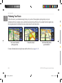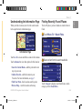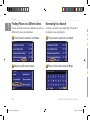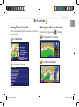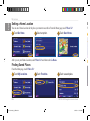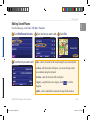
1
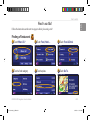
GPS NAVIGATION SYSTEM
DNX7200
GPS NAVIGATION INSTRUCTION MANUAL
B64-3966-00
190-00771-00_0A.indb 1
1/12/2007 3:28:01 PM
WARNING
Read this manual carefully before starting to operate the Kenwood Car Navigation System and follow the manual’s instructions. Kenwood is not liable for problems or
accidents resulting from failure to observe the instructions in this manual.
190-00771-88_0A_EN.indd 2
5/24/2007 9:19:49 AM
Garmin is a registered trademark of Garmin Ltd. or its subsidiaries and may not be used without the express permission of Garmin. SiRF, SiRFstar and the SiRF logo are
registered trademarks of SiRF Technology, Inc. SiRFstarIII and SiRF Powered are trademarks of SiRF Technology.
DNX7200 GPS Navigation Instruction Manual
190-00771-88_0A_EN.indd 1
English
®
EN-
5/24/2007 9:19:49 AM
English
Table of Contents
Warning...................................................iii
Caution....................................................iv
Software License Agreement...................v
First Time Setup......................... vi
Product Registration...............................vi
Find It and Go!............................. 1
Finding a Restaurant ............................. 1
Following Your Route.............................. 2
Where To?.................................... 3
Finding an Address ................................ 3
Finding a Place Using the Map............... 4
Understanding the Information Page...... 5
Finding Recently Found Places ............. 5
Finding Places in a Different Area........... 6
Narrowing Your Search........................... 6
My Locations .............................. 7
Saving Places You Find.......................... 7
Saving Your Current Location................. 7
Setting a Home Location......................... 8
EN-ii
190-00771-88_0A_EN.indd 2
Finding Saved Places............................. 8
Editing Saved Places.............................. 9
Deleting a Saved Place......................... 10
The Map and Other Tools.......... 11
Viewing the Map Page...........................11
Trip Computer....................................... 12
Turn List................................................ 12
GPS Info Page...................................... 13
Creating and Editing Routes.... 14
Creating a New Saved Route............... 14
Editing a Saved Route.......................... 15
Adding Stops to Your Route.................. 16
Saving the Active Route........................ 17
Navigating a Saved Route.................... 17
Recalculating the Route........................ 17
Deleting All Saved Routes.................... 17
Stopping Your Route............................. 17
Adding a Detour to a Route.................. 17
Adding Avoidances............................... 18
Using the Mileage Logs........................ 19
Traffic Information..................... 20
Viewing Traffic Events........................... 20
Avoiding Traffic..................................... 21
Changing the Traffic Settings................ 22
Adding a Traffic Subscription................ 23
Changing the Settings.............. 24
Adjusting the Volume............................ 24
Changing the General Settings............. 24
Changing the Navigation Settings......... 28
Viewing Unit Information (About).......... 29
Appendix.................................... 30
Using the Remote Control..................... 30
Updating Software and Map Data......... 30
Clearing All User Data........................... 30
Custom POIs (Points of Interest).......... 31
Index........................................... 32
Using The Logs.......................... 19
Adjusting the Track Log........................ 19
DNX7200 GPS Navigation Instruction Manual
5/24/2007 9:19:49 AM
English
Warning
This manual uses the term Warning to indicate a potentially hazardous situation, which, if not avoided, could result in death or serious injury.
Failure to avoid the following potentially hazardous situations could
result in an accident or collision resulting in death or serious injury.
When navigating, carefully compare information displayed on the unit to
all available navigation sources, including information from street signs,
visual sightings, and maps. For safety, always resolve any discrepancies or
questions before continuing navigation.
Always operate the vehicle in a safe manner. Do not become distracted
by the unit while driving, and always be fully aware of all driving
conditions. Minimize the amount of time spent viewing the screen of the
unit while driving and use voice prompts when possible.
Do not enter destinations, change settings, or access any functions
requiring prolonged use of the unit’s controls while driving. Pull over in
a safe and legal manner before attempting such operations.
Keep the system’s volume at a low enough level to be able to hear
outside noises while driving. If you can no longer hear outside noises,
you may be unable to react adequately to the traffic situation. This may
cause accidents.
DNX7200 GPS Navigation Instruction Manual
190-00771-88_0A_EN.indd 3
This navigation system can be used when the ignition key is turned to
ON or ACC. However, to preserve the battery, it should be used with
the engine running whenever possible. Using the navigation system for
a long time with the engine switched off can cause the battery to run
down.
The navigation system will not display the correct current position of the
vehicle the first time it is used after purchase, or if the battery has been
removed for a long time. GPS satellite signals will soon be received,
however, and the correct position will be displayed.
Be careful of the surrounding temperature. Using the navigation system
at extremely high or low temperatures can lead to malfunction or
damage. Also note that the unit can be damaged by strong vibration or
metal objects or by water getting inside the unit.
EN-iii
5/24/2007 9:19:49 AM
English
Preface
Caution
This manual uses the term Caution to indicate a potentially hazardous situation, which, if not avoided, may result in minor injury or property damage. It
may also be used without the symbol to alert you to avoid unsafe practices.
Failure to avoid the following potentially hazardous situations may
result in injury or property damage.
The unit is designed to provide you with route suggestions. It does not
reflect road closures or road conditions, traffic congestion, weather
conditions, or other factors that may affect safety or timing while
driving.
Use the unit only as a navigational aid. Do not attempt to use the unit
for any purpose requiring precise measurement of direction, distance,
location, or topography.
The Global Positioning System (GPS) is operated by the United
States government, which is solely responsible for its accuracy and
maintenance. The government’s system is subject to changes which
could affect the accuracy and performance of all GPS equipment,
including the unit. Although the unit is a precision navigation device,
any navigation device can be misused or misinterpreted and, therefore,
become unsafe.
Important Information
Map Data Information: One of the goals of Garmin is to provide customers with the most complete and accurate cartography that is available to
us at a reasonable cost. We use a combination of governmental and private data sources, which we identify in product literature and copyright messages
displayed to the consumer. Virtually all data sources contain inaccurate or incomplete data to some extent. In some countries, complete and accurate map
information is either not available or is prohibitively expensive.
EN-iv
190-00771-88_0A_EN.indd 4
DNX7200 GPS Navigation Instruction Manual
5/24/2007 9:19:49 AM
Software License Agreement
English
e,
re,
Preface
BY USING THE DNX7200, YOU AGREE TO BE BOUND BY THE
TERMS AND CONDITIONS OF THE FOLLOWING SOFTWARE
LICENSE AGREEMENT. PLEASE READ THIS AGREEMENT
CAREFULLY.
Garmin grants you a limited license to use the software embedded in this
device (the “Software”) in binary executable form in the normal operation
of the product. Title, ownership rights, and intellectual property rights in
and to the Software remain in Garmin.
You acknowledge that the Software is the property of Garmin and
is protected under the United States of America copyright laws and
international copyright treaties. You further acknowledge that the
structure, organization, and code of the Software are valuable trade secrets
of Garmin and that the Software in source code form remains a valuable
trade secret of Garmin. You agree not to decompile, disassemble, modify,
reverse assemble, reverse engineer, or reduce to human readable form the
Software or any part thereof or create any derivative works based on the
Software. You agree not to export or re-export the Software to any country
in violation of the export control laws of the United States of America.
DNX7200 GPS Navigation Instruction Manual
190-00771-88_0A_EN.indd 5
EN-
5/24/2007 9:19:49 AM
English
Preface
First Time Setup
The first time you use your Kenwood Navigation System, you need to complete a series of steps to setup the system.
These steps normally have to be performed only once.
• Select a language
• Select your current time zone
• Select whether you want your system to auto-adjust for daylight saving time
• Select your preferred units of measure (statute or metric)
Follo
Fin
➊T
Product Registration
After completing Setup, your system will display its registration code. This
screen is only shown once. After setup, the code may be accessed from the
Main Menu by selecting Settings >
About > Software.
➍T
Connect to http://my.garmin.com to register your Kenwood Navigation System.
Doing so allows you to sign up for e-mail notifications of the latest software
and map updates from Garmin.
EN-vi
190-00771-88_0A_EN.indd 6
DNX7200 GPS Navigation Instruction Manual
5/24/2007 9:19:50 AM
Find It and Go!
English
Find It and Go!
Follow the instructions on the next two pages to find a place and go to it!
Finding a Restaurant
➊ Touch Where To?
➋ Touch Food, Hotel….
➌ Touch Food & Drink.
➍ Touch a food category.
➎ Touch a place.
➏ Touch Go To.
DNX7200 GPS Navigation Instruction Manual
190-00771-88_0A_EN.indd 1
EN-
5/24/2007 9:19:51 AM
English
Find It and Go!
Following Your Route
Follow the route to your destination using the map. As you travel, the navigation system guides you to your
destination with voice prompts, arrows, and directions along the top of the map. If you depart from the original route,
the navigation system recalculates the route and provides new route instructions.
Fin
➊F
W
Your route is marked
with a green line.
Follow the arrows.
A checkered flag marks
your destination.
For more information about using the map and the other tools, see pages 11–13.
EN-
190-00771-88_0A_EN.indd 2
➍E
t
DNX7200 GPS Navigation Instruction Manual
5/24/2007 9:19:52 AM
Where To?
English
oute,
Where to?
Finding an Address
➊ From the Menu page, touch
➋ Select a state. Select a city
➌ Enter the address number
➍ Enter the street name and
➎ Select the street. Select the
➏ Select the address, if
Where To? > Address.
touch Done.
DNX7200 GPS Navigation Instruction Manual
190-00771-88_0A_EN.indd 3
or enter a postal code.
city, if necessary.
and touch Done.
necessary. Touch Go To.
EN-
5/24/2007 9:19:52 AM
English
Where to?
Finding a Place �����������
Using the Map
From the Menu page, touch
View Map. You
can also touch Where to? > Browse Map. Touch
anywhere on the map to recenter the map on that
location.
➊ Touch any object on the map. Touch Review.
Tips for Browsing the Map
• Use the
and
icons to zoom in and out.
• Touch an object on the map. The map recenters on
that location, and an arrow appears pointing at the
object you selected.
• Touch Review to open the location’s information
page; for more information, see the next page.
• Touch Save As Favorite to save the location
selected by the pointer to your Favorites.
• Touch Back to return to the previous screen.
➋ Touch Go To or Advanced.
EN-
190-00771-88_0A_EN.indd 4
DNX7200 GPS Navigation Instruction Manual
5/24/2007 9:19:53 AM
Understanding the Information Page
When you find a location, select it in the search results
list to open the item’s information page.
Finding Recently Found Places
The last 50 places you have found are stored in Recent
Finds.
English
on
he
Where to?
➊ Touch Where To? > Recent Finds.
n
Information Page
Touch Go To to create and follow a route to this location.
Touch Advanced to view other options for this location:
• Insert in Current Route—add this point as the next
stop in your route.
• Add As Favorite—add this location to your
Favorites. For more information, see page 7.
• Find Near Point—find a location near this point.
• Browse Map—view this location on the map.
DNX7200 GPS Navigation Instruction Manual
190-00771-88_0A_EN.indd 5
➋ Select an item from the search results list.
Touch Category to display recent finds from a certain
category, such as Food, Hotel….
EN-
5/24/2007 9:19:53 AM
English
Where to?
Finding Places in a Different Area
You can search for locations in a different area, such as a
different city or near your destination.
➊ From the search results list, touch Near….
Narrowing Your Search
To narrow your search, you can spell part of the name of
the location you are searching for.
➊ From the search results list, touch Spell.
Sav
After
in the
➊T
➋ Select one of the search options.
➋ Enter part of the name and touch Done.
➋T
EN-
190-00771-88_0A_EN.indd 6
DNX7200 GPS Navigation Instruction Manual
5/24/2007 9:19:54 AM
My Locations
Saving Places You Find
After you have found a place you want to save, select it
in the results list.
➊ Touch Advanced.
➋ Touch Add As Favorite.
DNX7200 GPS Navigation Instruction Manual
190-00771-88_0A_EN.indd 7
English
My Locations
Saving Your Current Location
From the Menu page, touch
View Map.
➊ Touch anywhere on the map.
➋ Touch Save As Favorite.
EN-
5/24/2007 9:19:55 AM
English
My Locations
Setting a Home Location
Edi
You can set a Home Location for the place you return to most often. From the Menu page, touch Where To?
➊ Touch Go Home.
➋ Select an option.
From
➌ Touch Save Home.
➊T
After you set your Home Location, touch Where To? and then touch Go Home.
➍T
Finding Saved Places
From the Menu page, touch Where To?
➊ Touch My Locations.
EN-
190-00771-88_0A_EN.indd 8
➋ Touch Favorites.
➌ Touch a saved place.
DNX7200 GPS Navigation Instruction Manual
5/24/2007 9:19:56 AM
My Locations
English
Editing Saved Places
From the Menu page, touch Tools > My Data > Favorites.
➊ Touch Edit/Review Favorites. ➋ Touch the item you want to edit. ➌ Touch Edit.
➍ Touch the item you want to edit.
Name—enter a new name for the location using the on-screen keyboard.
Location—edit the location of the place; you can use the map or enter
new coordinates using the keyboard.
Elevation—enter the elevation of the saved place.
Category—assign this place to a category; touch
categories.
to view the
Symbol—select a symbol that is shown on the map for this location.
DNX7200 GPS Navigation Instruction Manual
190-00771-88_0A_EN.indd 9
EN-
5/24/2007 9:19:57 AM
English
My Locations
Deleting a Saved Place
From the Menu page, touch Tools > My Data > Favorites.
➊ Touch Delete Favorites.
➋ Touch By Selection.
➌ Touch a saved location.
Vie
From
show
➍ Touch Delete.
By Selection—touch each location and delete it individually.
By Category—select one category to delete all of the locations assigned
to that category.
Delete All—removes all saved places from your Favorites.
EN-10
190-00771-88_0A_EN.indd 10
DNX7200 GPS Navigation Instruction Manual
5/24/2007 9:19:57 AM
Tou
The Map and Other Tools
English
The Map and Other Tools
Viewing the Map Page
From the Menu page, touch View Map to open the map. Touch an area of the map to see additional information, as
shown below. The position icon shows your current location.
While navigating a route, touch the green
text bar to open the Turn List. See page 12.
Touch
Reshow the last turn.
Touch
to zoom out.
to zoom in.
Touch the Speed or Arrival
data field to open the Trip
Computer. See page 12.
ed
Touch the map to view and
browse a 2-D map.
Map Page while Navigating a Route
DNX7200 GPS Navigation Instruction Manual
190-00771-88_0A_EN.indd 11
EN-11
5/24/2007 9:19:58 AM
English
The Map and Other Tools
Trip Computer
Turn List
Trip Computer, select Speed or Arrival on
To view the �����������������������
the map. Or, from the Menu page, touch Tools > Trip
Computer.
While navigating a route, touch the green text bar on the
map page to open the Turn List. Or, from the Menu page,
touch Tools > Turn List.
The Trip Computer indicates your current speed and
provides helpful statistics about your trip.
Current speed
Current
direction
of travel
Distance to your final
destination
Total
distance
traveled
(odometer)
Touch Reset Trip to reset all information on the Trip
Computer. To reset the Maximum Speed, touch Reset
Max.
EN-12
190-00771-88_0A_EN.indd 12
The Turn List displays a list of turn-by-turn instructions
for your entire route as well as arrival information.
Direction of this turn
GPS
From
the u
the M
S
Sat
str
Distance to this turn
Turn directions
Touch View All to see all the turns in the route. Touch
and
to scroll through the list.
Touch a turn to see the turn on a map (the Next Turn
page). Touch
and
to scroll through all the
turns in the route. Touch
and
to zoom in and out
of the turn on the map.
DNX7200 GPS Navigation Instruction Manual
5/24/2007 9:19:58 AM
The s
satell
satell
satell
The Map and Other Tools
From the Menu page, touch the signal strength bars in
the upper left corner to view the GPS Info page. Or, from
the Menu page, touch Tools > GPS Info.
Sky view
Satellite signal
strength bars
The sky view shows the satellites you are receiving. The
satellite signal strength bars indicate the strength of each
satellite you are receiving. A solid bar indicates the GPS
satellite is ready for use.
DNX7200 GPS Navigation Instruction Manual
190-00771-88_0A_EN.indd 13
GPS Settings
From the Menu page, touch Settings > General > GPS.
You can also access the GPS Settings by touching the
GPS Settings button on the GPS Info page.
English
GPS Info Page
Use Indoors—touch Yes to turn the GPS receiver off.
Set Position—set your position, if Use Indoors is
enabled. Select your location on the map and touch OK.
WAAS/EGNOS—disable and enable WAAS/EGNOS.
WAAS and EGNOS are systems of satellites and ground
stations that provide GPS signal corrections, giving you
even better position accuracy. To learn about WAAS and
EGNOS, visit www.garmin.com/aboutGPS/waas.html.
EN-13
5/24/2007 9:19:59 AM
English
Creating and Editing Routes
Creating and Editing Routes
Edi
From
Creating a New Saved Route
From the Menu page, touch Tools > My Data > Routes.
➊ Touch Create New
➋ Select an option and touch
Saved Route.
Next. Select the starting point.
➊T
➌ Select an option and touch
Next. Select the ending point.
➍T
➍ To add a stop, touch Yes, then ➎ Select your preference .
touch Next. Select the point.
EN-14
190-00771-88_0A_EN.indd 14
and touch Next.
➏ Touch Finish.
DNX7200 GPS Navigation Instruction Manual
5/24/2007 9:20:00 AM
Creating and Editing Routes
English
Editing a Saved Route
From the Menu page, touch Tools > My Data > Routes.
➊ Touch Edit/Review Routes.
➋ Touch the route to edit.
➌ Touch Edit.
ch
point.
➍ Touch the item to edit.
Rename—enter a new name for the route using the on-screen keyboard.
Edit/Review Points—add, arrange, remove, re-order, and review points
in the route. For more info, see the next page.
Change Preference—change calculation preference to Faster Time,
Shorter Distance, or Off Road.
Delete Route—delete this route.
DNX7200 GPS Navigation Instruction Manual
190-00771-88_0A_EN.indd 15
EN-15
5/24/2007 9:20:00 AM
English
Creating and Editing Routes
Adding Stops to Your Route
You can add midpoints (also called via points or stops) to your route as you create it, as described on page 14. You
can also add points to your route when you edit the route, as described below. Follow the steps on the previous page
to begin editing the route.
➌ Touch where you to want to
Touch
Edit/Review
Points.
add the point.
➊
➋ Touch Add.
➍ Touch a method and then
select the point.
➎ Add points as necessary.
Touch Done when finished.
Auto Arrange—arranges the points
to provide the shortest route.
Remove—touch the point you want
to remove and then touch Remove.
Re-Order—touch the point to move
and touch Move Up or Move Down.
Touch Done when finished.
EN-16
190-00771-88_0A_EN.indd 16
DNX7200 GPS Navigation Instruction Manual
5/24/2007 9:20:01 AM
Creating and Editing Routes
From the Menu page, touch Tools > My Data >
Routes > Save Active Route.
to
Navigating a Saved Route
From the Menu page, touch Tools > My Data >
Routes > Navigate Saved Route. Touch the route
you want to navigate.
Recalculating the Route
From the Menu page, touch Tools > My Data >
Routes > Recalculate Route.
Deleting All Saved Routes
From the Menu page, touch Tools > My Data >
Routes >
> Delete All Saved Routes.
Stopping Your Route
From the Menu page, touch Stop. Then touch Yes.
DNX7200 GPS Navigation Instruction Manual
190-00771-88_0A_EN.indd 17
Adding �a Detour to a Route
English
Saving the Active Route
If you need to take a detour from your current route,
open the Menu page and touch Detour.
1 kilometer, 5 kilometers, or 10 kilometers—select
the distance of the detour. For example if a road sign
indicates that the street is closed for the next five
kilometers, touch 5 kilometers in the list. The navigation
system recalculates your route for the next five
kilometers.
Detour by Road(s) In Route—select roads in your route
to avoid. For example, if the highway ramp is closed,
select the ramp in the list of roads. The navigation
system recalculates your route to avoid that ramp.
Detour by Traffic Event on Route—if you are using
an FM Traffic Receiver, you can detour around traffic
events.
Remove All Detours—touch to remove any detours you
have entered for the route.
EN-17
5/24/2007 9:20:01 AM
English
Creating and Editing Routes
Adding Avoidances
From the Menu page, touch Settings > Navigation >
to view more road types to avoid.
Creating Custom Avoids
You can enter specific areas and roads
to avoid in your routes. From the
Avoidance Setup menu, touch
two times and then touch Custom
Avoids.
> Avoidance Setup. Select the road type to avoid. Touch
➊ Touch Add New Avoid Area
➋ Touch the first corner
➌ Touch the second corner
➍ Touch Finish.
or Add New Avoid Road.
and touch Next.
EN-18
190-00771-88_0A_EN.indd 18
and touch Next.
DNX7200 GPS Navigation Instruction Manual
5/24/2007 9:20:02 AM
Using The Logs
Adjusting the Track Log
As you travel, the navigator creates a bread crumb trail
(track log) of your movement. From the Menu page,
touch Tools > My Data > Track Log.
English
Using The Logs
Using the Mileage Logs
You can keep four different mileage logs of your travels.
From the Menu page, touch Tools > My Data > Mileage
Log. Touch a log to edit it.
Recording—turn off and on the track log recorder.
Percentage Full—displays the current percentage
capacity of the track log. To clear the track log, touch
Percentage Full > Yes > OK.
Map Display—displays the current track log on the
map. Select a zoom setting at which the track log is
shown. Touch OK. Your track log is displayed as a fine
dotted line on the map.
Name—enter a new name.
Distance—reset the mileage log.
Active—make this log active or inactive.
DNX7200 GPS Navigation Instruction Manual
190-00771-88_0A_EN.indd 19
EN-19
5/24/2007 9:20:02 AM
English
Traffic Information
Traffic Information
Using an optional FM Traffic Receiver, the navigation
system can receive and use traffic information. When a
traffic message is received, you can see the event on the
map and change your route to avoid the traffic incident.
For more information about the FM Traffic Receiver,
visit the Garmin Web site (www.garmin.com). For
participating FM subscription providers and covered
cities, refer to http://www.garmin.com/fmtraffic.
Make sure the FM Traffic Receiver is connected to the
DNX7200.
Avo
Viewing Traffic Events
From the Menu page, touch Tools > Traffic Info. Select
an item in the Traffic Events list to view the details.
Touch Near… to view traffic at a different location.
190-00771-88_0A_EN.indd 20
➊F
Traffic Symbol
Traffic
source
and
signal
strength
Color
code
Traffic Events List
EN-20
The m
road
Sev
The b
=
=
=
DNX7200 GPS Navigation Instruction Manual
5/24/2007 9:20:03 AM
affic
urce
nd
gnal
ngth
Avoiding Traffic
The map page displays a
when there is a traffic event of medium or high severity on your current route or on the
road you are driving. When you are following a route, touch the
to avoid the traffic.
➊ From the map, touch
.
➋ Touch an item to avoid.
English
lect
Traffic Information
➌ Touch Detour Around.
Severity Color Code
The bars to the left of the traffic symbols indicate the severity of the traffic incident:
= Low severity (green); traffic is still flowing.
= Medium severity (yellow); traffic is a bit congested.
= High severity (red); traffic is heavily congested or stopped.
DNX7200 GPS Navigation Instruction Manual
190-00771-88_0A_EN.indd 21
EN-21
5/24/2007 9:20:03 AM
English
Traffic Information
for information about adding an FM Traffic subscription.
Traffic Symbols
International
Symbols
Meaning
Road Condition
North
American
Symbols
Road Construction
Congestion
Accident
Incident
Information
Symbols on Map—change the symbols used to indicate
the type of traffic event. Touch Style to use American
or International symbols. Touch each symbol to set the
zoom scale at which each symbol appears on the map.
Severity on the Map—select the scale at which the
severity is displayed on the map.
Avoid Traffic—select Yes to avoid traffic events when
generating a route.
From the Menu page, touch Settings > Traffic.
Subscriptions—view your traffic subscriptions. Touch
the subscription to display the expiration date. To add a
subscription, touch Add Subscription. See the next page
190-00771-88_0A_EN.indd 22
Your
add s
FM T
25‑ch
➊T
Audio Notification—turn on or off the audio notification
when a traffic event occurs on the road you are traveling
on or the route you are navigating.
Changing the Traffic Settings
EN-22
Add
DNX7200 GPS Navigation Instruction Manual
5/24/2007 9:20:04 AM
➎T
Traffic Information
Your FM Traffic Receiver may come with a subscription, or you may be in an area with free service. You can also
add subscriptions to expand your service area. Touch Settings > About > FM Traffic Receiver and write down your
FM Traffic Receiver’s unit ID. Go to http://www.garmin.com/fmtraffic to purchase a traffic subscription and get a
25‑character traffic subscription code.
➊ Touch Settings.
➋ Touch Traffic.
➌ Touch
➎ Touch Next.
➏ Enter the code and
➐ Touch OK.
touch Next.
DNX7200 GPS Navigation Instruction Manual
190-00771-88_0A_EN.indd 23
Subscriptions.
English
Adding a Traffic Subscription
➍ Touch Add
Subscription
EN-23
5/24/2007 9:20:05 AM
English
Changing the Settings
Changing the Settings
Adjusting the Volume
From the Menu page, touch Volume. Touch the
and
to adjust the volume. Touch Mute to silence the
audio output.
Changing the General Settings
From the Menu page, touch Settings >
General.
Two
text-t
GPS
Touch Settings to open the Audio Settings page. See
page 25 for more information.
From the Menu page, touch Settings > General > GPS.
See page 13.
Changing the Language
190-00771-88_0A_EN.indd 24
Lang
text-t
Engli
to-sp
that a
exten
name
Lang
voice
speak
From the Menu page, touch Settings > General >
Language.
EN-24
Voice
prom
and t
OK.
DNX7200 GPS Navigation Instruction Manual
5/24/2007 9:20:05 AM
Changing the Settings
Two different types of voice languages are available:
text-to-speech and pre-recorded.
Languages noted with a person’s name and (TTS) are
text-to-speech (TTS) voices: for example, American
English-Jill (TTS) is a text-to-speech voice. The textto-speech voices “read” and “speak” the same words
that are displayed on the screen. The voices have an
extensive vocabulary, and they pronounce the street
names as you approach turns.
Languages without a person’s name are pre-recorded
voices, which have a limited vocabulary and do not
speak names of locations or streets.
NOTE: If you change the Voice Language, you
must restart to complete this change.
DNX7200 GPS Navigation Instruction Manual
190-00771-88_0A_EN.indd 25
Text Language—change the on-screen text to the
selected language. Changing the text language does not
change the language of map data or user-entered data.
English
Voice Language—change the language for all voice
prompts and messages. Touch the voice you want to use
and touch OK. To delete that voice, touch Delete and
OK.
Speech Rate—select the rate at which prompts are
spoken.
Customizing the ���������������
Audio Settings
From the Menu page, touch Settings > General >
Audio.
Attention Tone—turn on or off the attention tone
sounded before voice prompts.
Touch Screen Tone—turn on or off the tone sounded
each time you touch the screen.
Keypress Tone—turn on or off the tone sounded each
time you press a button on the remote.
Speed Adjusted Volume—select how much the volume
increases as your speed increases. Low increases your
volume slightly; High increases your volume the most.
EN-25
5/24/2007 9:20:05 AM
English
Changing the Settings
Customizing Proximity Alerts
From the Menu page, touch Settings > General >
Proximity Alerts to adjust the notifications for custom
POIs you have loaded. See page 31.
Changing Your Time Settings
From the Menu page, touch Settings > General > Time.
Time Zone—select your time zone.
Time Format—select 12 or 24 hour time format.
Daylight Saving—select Auto, Yes, or No. The Auto
setting automatically adjusts the time for daylight saving
based on your time zone.
Turning Safe Mode Off and On
From the Menu page, touch Settings > General > Safe
Mode. Turn on or off the Safe Mode, which disables all
unit functions that require significant operator attention
and could become a distraction while driving. When
it is turned on, Safe Mode operates when the vehicle’s
parking break is disengaged.
Changing the Map Settings
From the Menu page, touch Settings >
Map.
Selecting Units
From the Menu page, touch Settings > General > Units.
Change units of measure to Statute, Metric, or Custom.
EN-26
190-00771-88_0A_EN.indd 26
Map Detail—adjust the amount of detail shown on the
map. Displaying more detail causes the map to redraw
slowly.
DNX7200 GPS Navigation Instruction Manual
5/24/2007 9:20:05 AM
Changing the Settings
can customize this setting to Never or While Routing.
• 2D North Up—display the map in 2 dimensions
(2‑D) with North at the top.
• 2D Track Up—display the map in 2 dimensions
(2‑D) with your direction of travel at the top of the
screen.
• 3D Track Up—display the map in 3 dimensions
(3‑D) with your direction of travel at the top of the
screen. This is the default map view.
Color Mode—select Day for a bright background.
Select Night for a black background. Select Auto to
automatically switch between the two.
Map Data Fields—customize the width and contents of
the data fields displayed on the map page. Normal is the
default setting.
Auto Zoom—disable or enable automatic zooming on
the map for optimal viewing. You can also specify a
maximum Auto Zoom distance, from 30 meters to 500
kilometers.
3.
4.
5.
6.
7.
8.
Route Color—select the color of the route line.
Dim Roads—dim roads that are not on your route. You
DNX7200 GPS Navigation Instruction Manual
190-00771-88_0A_EN.indd 27
1. From the Menu page, touch Settings >
> Map Data Fields.
2. Select Wide or Thin. Then touch Next.
English
Orientation—change the perspective of the map.
Map >
Touch the navigation data field you want to customize.
Select the type of data field.
Select how the data field appears.
Touch OK. Repeat for each navigation data field.
Touch Next to customize the non-navigating data fields.
Touch Finish to return to the Map Settings menu.
EN-27
5/24/2007 9:20:06 AM
English
Changing the Settings
Text Size—adjust the display size of text on the map.
Zoom Level Detail—customize which map items appear
at various zoom levels. For each map item, you can
select Off, Auto, or a maximum zoom distance, from 30
meters to 1200 kilometers.
Note: More detail increases the time it takes the
map to refresh.
Detail Maps—enable and disable the preloaded detailed
maps.
Changing the Navigation Settings
From the Menu page, touch Settings >
Navigation.
Vehicle—specify your vehicle type.
Preference—select a preference for route calculations.
Ask Preference—select whether the unit asks for your
preference each time it calculates a route.
Base Map—select the appropriate base map (Americas,
Atlantic, or Pacific) depending on your location.
Next Turn Pop-up—select when the Next Turn pop-up
window appears.
Off-Route Recalculation—set the way the unit
responds when off the route. You can silence the “offroute, recalculating” message here.
EN-28
190-00771-88_0A_EN.indd 28
DNX7200 GPS Navigation Instruction Manual
5/24/2007 9:20:06 AM
Changing the Settings
Detail Maps—view information about the preloaded
detailed maps.
Avoidance Setup—see page 18.
Restoring the Settings
Adjusting the Traffic Settings
To restore the unit to its original settings, open the Menu
page and touch Settings > Restore Defaults > Yes.
See page 22.
English
Continuous Auto Routing—enable or disable the
Continuous Auto Routing feature. This feature allows
the unit to continually search for a better route to your
destination. Continuous Auto Routing may be useful if a
traffic accident occurs or there are time-restricted turns
on the current route. A
is displayed on the map when
a better route than the one you are currently taking is
available. Touch the
to take the better route.
FM Traffic Receiver—If you have a FM Traffic
Receiver, you can view the FM Traffic Receiver’s unit
ID.
GPS SW Version—SiRF version being used in the GPS
is shown.
Viewing ������������������
Unit Information �������
(About)
From the Menu page, touch Settings >
About.
Software—the unit’s software version, audio version,
unit ID, and registration code are listed.
DNX7200 GPS Navigation Instruction Manual
190-00771-88_0A_EN.indd 29
EN-29
5/24/2007 9:20:06 AM
English
Appendix
Appendix
Using the Remote Control
You can use a standard Kenwood system remote control
with the navigation system.
Updating Software and Map Data
To update the unit software, you must have an SD card,
an SD card reader, and an Internet connection.
To update the navigation software:
1. Go to www.garmin.com/Kenwood. Select Updates and
Downloads.
2. Click Download next to the unit software.
3. Follow the instructions on the website to complete the
installation of the updated software
EN-30
190-00771-88_0A_EN.indd 30
You can also purchase map data updates. Check
www.garmin.com/Kenwood to see if an update for your
map software is available.
Clearing All User Data
You can clear all user data, including all favorite places,
routes, custom POIs, tracks, mileage logs, and your
home location, at one time.
CAUTION: You cannot recover your user data
once it is deleted.
1. Touch Tools > My Data > Clear All.
2. Touch Yes. The navigation system restarts.
DNX7200 GPS Navigation Instruction Manual
5/24/2007 9:20:06 AM
Cus
You c
datab
Intern
infor
zones
of the
After
POI L
you c
DNX
www
Load
the H
Appendix
Adjusting the Proximity Alerts
After downloading your POI database, use the Garmin
POI Loader to install the POIs onto an SD card. Then,
you can use the SD card to load the POIs into the
DNX7200. The POI Loader is available at
www.garmin.com/products/poiloader. Refer to the POI
Loader Help file for more information; press F1 to open
the Help file.
Audio Notifications—turn off or on the alerts that sound
as you approach a custom POI.
You can manually load custom points of interest (POI)
databases, available from various companies on the
Internet. Some custom POI databases contain alert
information for points such as safety cameras and school
zones. The unit can notify you when you approach one
of these points.
Caution: Garmin is not responsible for the
consequences of using a custom POI database or
the accuracy of the safety camera or other custom
POI database.
DNX7200 GPS Navigation Instruction Manual
190-00771-88_0A_EN.indd 31
To turn on or off the proximity alerts for custom POIs,
open the Menu page and touch Settings > General >
Proximity Alerts.
English
Custom POIs (Points of Interest)
Visual Notification—turn off or on the pop-up alerts
that appear as you approach a custom POI.
Continuous Notification—select which alerts (which
types of POIs) you will be continually notified of.
EN-31
5/24/2007 9:20:06 AM
English
Index
Index
Symbols
2 Dimensional 27
3 Dimensional 27
A
Adding a traffic subscription 23
Add as favorite 5
Audio version 29
Auto arrange, route 16
Avoidances 18
Avoiding traffic 21
B
Better route 29
Browse the map 4
C
Category for saved locations 9
Changing settings 24–29
general settings 24
map settings 26
navigation settings 28
volume 24
EN-32
190-00771-88_0A_EN.indd 32
Color mode 27
Continuous auto routing 29
Coordinates, entering 9
Custom avoids 18
Custom POIs 31
D
Data fields
customizing 27
location of 11
Default settings 29
Deleting
all saved routes 17
My Favorites 10
routes 15
saved locations 10
Detour, adding 17
Driving directions 12
E
Edit/Review points 15
Editing saved places 9
EGNOS 13
Elevation, entering 9
Expanding your search 6
F
License agreement v
Location of saved place,
editing 9
Finding places 3–6
address 3
item on the map 4
recent finds 5
restaurant 1
saved places 8
spell the name 3
Find near point 5
Following your route 2
M
Map 11
browse 4
customize 26
orientation 27
zoom 4, 11, 12
Metric units 26
Midpoints in the route 16
Mileage logs 19
My Locations 7–10
Go Home 8
My Favorites 8
Recent finds 5
G
General settings 24
Go Home 8
GPS info page 13
H
Home location 8
I
N
Insert point in current route , 5
Items to avoid 29
L
Language 24
Name of a saved place 9, 15
Narrowing your search 6
Navigating a saved route 17
Navigation settings 28
Near button 6
North Up 27
DNX7200 GPS Navigation Instruction Manual
5/24/2007 9:20:07 AM
Index
Odometer 12
Off-Route voice 28
Original settings 29
P
Places
editing 9
finding 3–6
saving 7
Position icon 11
Product Registration vi
Proximity alert 31
R
Re-order points in route 16
Recalculating the route 17
Recently found places 5
Registering your system vi
Registration code vi, 29
Remote control 30
Remove all detours 17
Remove points from route 16
Rename
route 15
saved location 9
Reset
max. speed 12
mileage log 19
trip computer 12
Restoring settings 29
Routes 14–18
add point 5
create new 14
detour 17
edit a saved route 15
navigate a saved route 17
save the active route 17
stop 17
Routing preferences 28
S
Safe mode 26
Saved places
deleting 10
editing 9
finding 8
DNX7200 GPS Navigation Instruction Manual
190-00771-88_0A_EN.indd 33
Saved routes
adding points to 16
deleting 15, 17
editing 15
navigating 17
Saving places you find 7
Saving the active route 17
Set position 13
Software license agreement v
Software version 29
Speed (Speedometer) 12
Spell 6
Stop navigation 17
Symbol for locations 9
Vehicle type 28
Via points 16
Viewing the map 11
Voice language 25
Volume 24
T
W
Text language 25
Time 26
Track log 19
Track up 27
Traffic
avoid 21
events 20
Traffic information 20–23
Trip Computer 12
Turn List 12
English
O
U
Unit ID
FM Traffic Receiver 29
software 29
Use Indoors 13
V
Where To? 3–6
Z
Zoom 4, 11, 12
EN-33
5/24/2007 9:20:07 AM
DNX7200AN4̲Navicover̲En.indd 42
07.8.9 7:23:41 PM
DNX7200AN4̲Navicover̲En.indd 43
07.8.9 7:23:42 PM
For the latest free software updates (excluding map data) throughout the life of your
Garmin products, visit the Garmin Web site at www.garmin.com.
© Copyright 2007 Kenwood Corporation and Garmin Ltd. or its subsidiaries
www.garmin.com
190-00771-88_0A_EN.indd 34
5/24/2007 9:20:07 AM