Transcript
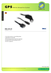
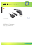
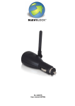
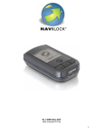
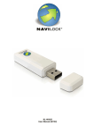
 Navilock
BT-451 Bluetooth GPS
NEW u-blox ANTARIS®4 SuperSense® Chipset
"The Navilock BT-451 Bluetooth GPS receiver combines new technology in a new design. Its ANTARIS®4
SuperSense® GPS chipset, developed by u-blox, brings unmatched positioning performance to PDA,
smartphone, notebook PC and mobile phone users. u-blox' high sensitivity GPS chip enables the receiver to
work even when placed in covert locations, such as trouser pockets or belt clips, without losing the signal.”
General specification
o u-blox ANTARIS*4 SuperSense” GPS Chipset
High Sensitivity (Tracking sensitivity: -158 dBm)
© 19 hrs battery life
WAAS, EGNOS und MSAS Support
* Very short TTFF (Time To First Fix)
e Support of NMEA 0183 Protocol
° Internal patch antenna
Mini USB port for power supply
Home and car charger as well as Mini-USB
° and belt pouch included in delivery
Specification
* Chipset: u-blox ANTARIS®4 SuperSense®
* Frequency: L1, 1575.42 MHz
® C/A Code: 1.023 MHz
® Channels: 16 channels max.
° Positions update rate: 4 Hz
° Tracking sensitivity: -158 dBm
® Acquisition sensitivity: -148 dBm
® Cold start sensitivity: -142 dBm
* Position accuracy 2,5m CEP2 5,0m SEP3and
SBAS' 2,0m CEP2 3,0m SEP3
®Speed: 0.1 m/s
° Time: 1us synchronized to GPS time
Time
9 Re-registration: 1 sec., average
© Hot start: 3,5 sec., average
© Warm start: 33 sec., average
© Cold start: 34 sec., average
Date
e Basic settings : WGS-84
Dynamic facts
o Recepetion height: Max. 18,000 Meter (60,000 Feet)
e Reception speed: Max. 515 Meter/sec
o Speed-up: Max. 4g
o Shock: Max. 20m/sec x 3
Power supply
© Power connection: 5V DC via Mini-USB connector
o Battery performance: 3,7V Li-ION 1000mA
Interface characteristics
e Baud rate: 9,600 bps
e Output protocol: NMEA 0183 GGA, GLL, GSA, GSV,
RMC, VTG
Physical characteristics
e Size: 71,20mm x 41,80mm x 21,80mm
e Working temperature range: -10°C to +60°C
Bundle Version with Navilock Europe Route Planner
and GPS Pilot or Directions Navigator 7 available
[> @blox Version
1 SBAS (Satellite Based Agmentation System) is the generic term that refers to differential GPS applied to a wide area, such as an entire
continent. WAAS and EGNOS are examples of SBAS networks, and are comprised of a series of reference stations that generate GPS
corrections which are broadcast to GPS rovers via geostationary satellites.
2 CEP (Circular Error Probable) - In a circular normal distribution, the radius of the circle containing 50 percent of
the individual measurements being made, or the radius of the circle within which there is a 50 percent probability of being located.
3 SEP (Spherical Error Probable) The radius of a sphere within which there is a 50 percent probability of locating a point or being located.
SEP is the three-dimensional analogue of CEP.
Product-No. 60307
www.navilock.com