1
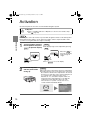
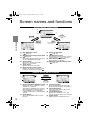
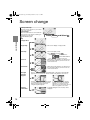
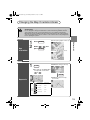
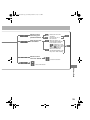
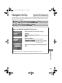
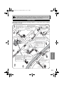
NAVIGATION SYSTEM
Navi_EA.book Page 2 Monday, March 28, 2005 4:13 PM
Contents, Accessories, and Laser
Before Use
Accessories
Please contact an Authorized Mazda Repairer if you are missing
any of the following accessories.
●Map Disc
●Owner’s Manual
CAUTION:
THIS PRODUCT IS A CLASS I LASER PRODUCT.
HOWEVER THIS PRODUCT USES A VISIBLE/
INVISIBLE LASER BEAM WHICH COULD CAUSE
HAZARDOUS RADIATION EXPOSURE IF DIRECTED.
BE SURE TO OPERATE THIS PRODUCT
CORRECTLY AS INSTRUCTED.
USE OF CONTROLS OR ADJUSTMENTS OR
PERFORMANCE OF PROCEDURES OTHER THAN
THOSE SPECIFIED HEREIN MAY RESULT IN
HAZARDOUS RADIATION EXPOSURE. DO NOT
OPEN COVERS AND DO NOT REPAIR YOURSELF.
REFER SERVICING TO QUALIFIED PERSONNEL.
Preparation
Immediate
use
Advanced
use
Laser products:
Wave length: 650 nm
Laser power: No hazardous radiation is emitted with safety protection.
If
necessary
2
Navi_EA.book Page 3 Monday, March 28, 2005 4:13 PM
Product
Accessories ...............................................................................................................2
Laser Product ............................................................................................................2
Contents ....................................................................................................................3
Safety Information......................................................................................................4
Introduction ................................................................................................................6
Names and Functions................................................................................................8
Activation .................................................................................................................10
Screen names and functions ...................................................................................12
Screen change ........................................................................................................14
● Changing the Map Orientation/Scale ............................................ 15
Before Use
Getting
started
Destination Entry and Route Search ........ 16
● Change (Change Search Area) ● Address
● Point of interest
● Emergency
● Memory Point
● Home
● Preset Destination
● Previous Destination
● Intersection
● Freeway On/Off Ramp
● Phone number
● Coordinates
● Select from map
Routing
Use POI ........................................................................................ 22
Character Entry .................................................................... 23
Direct Destination Input .............................................................. 24
POI Icons on Maps / Delete Destination ............................. 25
Route Options ............................................................................................... 26
Address Book ..........................................................................................................32
Voice Recognition .......................................................................... 38
Navigation Set Up....................................................................................................40
Precautions/System Performance ...........................................................................48
● Voice Guidance
● GPS
● Map Matching
● Positioning Accuracy
● Route Guide
● Route Search
Troubleshooting .......................................................................................................54
● Verification First
● Error Messages
Maintenance ............................................................................................................55
Address
Book
Voice
Recognition
Navigation
Set Up
As
necessary
3
Navi_EA.book Page 4 Monday, March 28, 2005 4:13 PM
Safety Information
Before Use
■ Read this owner’s manual for your Navigation System carefully before using the system.
They contain instructions about how to use the system in a safe and effective manner.
Mazda assumes no responsibility for any problems resulting from failure to observe the instructions
given in this manual.
■ This manual uses pictographs to show you how to use the product safely and to alert you to potential
dangers resulting from improper connections and operation. The meanings of the pictographs are
explained below. It is important that you fully understand the pictographs and explanations in order to
use this manual and the system properly.
Warning
Warning
The presence of this Warning symbol in the text is intended to
alert you to the importance of heeding the operation
instructions. Failure to heed the instructions may result in
severe injury or death.
■ Do not keep your eyes fixed on the monitor screen or operate the system
while driving.
Warnings
Do not change the settings and destination locations while driving. Minimize the time
spent on viewing the monitor screen and listening to the voice guidance while driving.
Operating the system will distract the driver from looking ahead of the vehicle and can
cause accidents. Always stop the vehicle in a safe location and use the parking brake
before operating the system.
■ Always obey local traffic regulations.
Your guided route may include roads that are not open to vehicles or are closed due to
traffic regulations. Comply with the local traffic regulations and take another route.
■ Do not use the unit when it is out of order.
If the unit is out of order (no image, no sound) or in an abnormal state (has foreign matter
in it, is exposed to water, is smoking, or smells), then turn it off immediately and consult
with an Expert repairer, we recommend an Authorized Mazda Repairer. Using the unit in
an out-of-order condition may lead to accidents, fires, or electric shocks.
■ Use the proper power supply.
This product is designed for operation with a negative grounded 12 V DC battery system.
■ Do not disassemble.
Do not disassemble the product or attempt to repair it yourself. If the product needs to be
repaired, take it to an Expert repairer, we recommend an Authorized Mazda Repairer.
4
Navi_EA.book Page 5 Monday, March 28, 2005 4:13 PM
Cautions
■ Do not use the product where it is exposed to water, moisture, or dust.
Exposure to water, moisture, or dust may lead to smoke, fire, or other damage to the unit.
Make especially sure that the unit does not get wet in car washes or on rainy days.
Before Use
Caution
The presence of this Caution symbol in the text is intended to
alert you to the importance of heeding the operation
instructions. Failure to heed the instructions may result in injury
or material damage.
Caution
■ Keep the voice guidance volume at an appropriate level.
Keep the volume level low enough to be aware of road and traffic conditions while driving.
■ Protect the Deck Mechanism.
Do not insert any foreign objects into the slot of this unit.
■ This navigation system is designed use for exclusively in automobiles.
This navigation system should only be installed in an automobile. Do not install it in a
ship, aircraft, or any other vehicles except an automobile. Do not use it detached from the
vehicle.
■ Do not insert or allow your hand or fingers to be caught in the unit.
To prevent injury, do not get your hand or fingers caught in moving parts or in the disc
slot. Especially watch out for infants.
Operation is subject to the following two conditions;
(1) this device may not cause interference, and
(2) this device must accept any interference,
including interference that may cause undesired operation of the device.
5
Navi_EA.book Page 6 Monday, March 28, 2005 4:13 PM
Introduction
Before Use
Use This Product Safety
■ Extremely
low or high temperatures may interfere with normal operation
The inside of the vehicle can become very hot or cold when it is parked for extended
periods in direct sunlight or in cold places with the engine turned off. The navigation system
may not operate normally under such circumstances. Turn off the navigation system until
the inside of the vehicle has cooled down or warmed up. If the system does not operate
thereafter, consult an Expert repairer, we recommend an Authorized Mazda Repairer.
Navigation System
This navigation system utilizes GPS* satellite signals, Speed sensor and Gyrosensor to track
and display your vehicle’s current position, and to guide you from your starting point to your
destination along a calculated route.
* : GPS (Global Positioning System) is a position detecting system utilizing the signals from GPS satellites
deployed by the U.S. Defense Department.
Screens
Screens displayed in this manual may differ from those on the actual display.
6
Navi_EA.book Page 7 Monday, March 28, 2005 4:13 PM
Before Use
7
Navi_EA.book Page 8 Monday, March 28, 2005 4:13 PM
Names and Functions
Before Use
VOICE key
VOICE
Initiates vocal guidance for route
maneuvers. Use when adjusting
the display(
page 13)
POS
Joystick
ENTER
Selects items
by tilting it up, down, right, and left.
RET
ENTER
RET key
Returns to the previous screen.
MENU
ZOOM key
ZOOM
Changes the map scale.
(
page 15)
DIM
TALK
8
Navi_EA.book Page 9 Monday, March 28, 2005 4:13 PM
ENTER
Displays your current position.
Before Use
POS (Position) key
POS
ENTER key
Executes a selected item.
MENU key
MENU
Select a menu.
(
page 13)
DIM key
DIM
Changes the display brightness.
(
page 13)
TALK Switch
TALK
Use for switching to voice
recognition or canceling.
9
Navi_EA.book Page 10 Monday, March 28, 2005 4:13 PM
Activation
Insert the map disc into the unit to start the Mobile Navigation System.
■ Map Disc
Cautions
● Refer to “Handling and Care of Map Discs” to know how to handle a map
disc (
page 55).
Note
●The map disc cannot be inserted or ejected while the ignition switch is in the OFF position.
●Remember that the battery can run down if the ignition switch is kept in the ON or ACC
position for a long time while the engine not running.
Getting started
1
Turn the ignition switch to
the ON position and press
OPEN
Note
●This display angle can be adjusted by pressing
to open the display.
TILT .
When the TILT is
pressed, the display
angle changes in
stages.
●Press OPEN to close the display.
2
Insert the map disc
with the printed side
facing up.
Note
●The main unit is located in the glove box compartment.
●Condensation may form on the optical lens or the map
disc inside the unit when the temperature in the vehicle
increases in a short time such as when heating the car
on a cold day. This condensation may cause
malfunctions. If so, unload the map disc and do not
operate the unit for approximately 1 hour. Wipe the
condensation off the map disc with a soft cloth.
If the unit does not operate correctly after 1 hour,
consult an Authorized Mazda Dealer.
[CAUTION] screen
10
Navi_EA.book Page 11 Monday, March 28, 2005 4:13 PM
3
Read CAUTION carefully,
and select
and
press ENTER .
Caution
Most functions are inhibited while the
vehicle is in motion.
Please read the handbook for operation
instructions.
Always obey traffic regulations.
●The Current Position screen appears.
●You can select the language by select
and press ENTER . You can also change the
selected language using Language Selection. (
page 47)
If 3 minutes elapse without any operation, the display changes automatically to Language
Selection. (
page 47)
●The CAUTION screen remains on the display unless you select
Getting started
Note
and press ENTER .
Removing the Map Disc
When the ignition switch is in the ACC position and press
Caution
(EJECT).
Do not get your hand or fingers caught in
moving parts or in the disc slot. This can
cause injuries. Children are inquisitive, try
to install or remove the map disc without
infants looking on.
Buttons on the screen
Select the buttons by using Joystick and press ENTER .
Colors for unavailable buttons will be pale.
11
Navi_EA.book Page 12 Monday, March 28, 2005 4:13 PM
Screen names and functions
Screens Before Setting Route
(1)
(2)
(4)
(3)
ENTER
ENTER
Current position screen
RET
RET
Getting started
Returns after a
few seconds.
Returns after a
few seconds. (5)
(6)
(7)
(1) Map Orientation control
(
page 15)
(2) GPS (Global Positioning System) marker
(
page 49)
(3) Clock
Clock will be displayed when you set up
Clock on Navigation Set Up On.
(4) Vehicle marker
Shows the current position and
direction of your vehicle.
(5) Scale display
Displays the scale of the map.
(6) Distance from current position
Displays the distance from the current
position to the position pointed by .
(8)
(9) (10)
(7) Screen Configuration
(
page 14)
(8) Set Destination button
The destination or way point will be set at the
position pointed by
in the scroll screen.
(9) Store Memory Point button
Stores markers on the map.
(10) POI (Point of Interest) Display button
(
page 22)
Screens During Route Guidance
(3)
ENTER
(2)
(1)
RET
(4)
Returns after a
few seconds.
(1) Distance and Time to Destination display
Displays the time* and distance to the
destination or way point.
Selecting this will display the next and
further information on the way point or
time and distance to the destination.
(* Either required time or estimated time
arrival)
(2) Route display
Shows the provided route as a thick
blue line.
12
(5)
(6)
(3) Turn Arrow display
Shows the direction to turn at the next
junction and the distance to the junction.
(4) Current Road Name
Shows the name of the road you are
currently driving on.
(5) Change Route button
Displays the Route Option menu so that
settings for route calculation can be changed.
(6) Volume button
Displays the volume adjustment screen.
Navi_EA.book Page 13 Monday, March 28, 2005 4:13 PM
Menu
Menu appears when pressing MENU .
Destination Entry and Route Search (
Address Book (
page 32)
Cancel Guidance (
page 25)
Navigation Set Up (
page 40)
Route Options (
page 26)
page 16)
Display Menu screen will be shown when you press VOICE
(DISP) and hold.
Note
Display Menu screen will be disappeared when they have been unused during a few seconds.
■ Adjusting
Getting started
Screen adjustments and settings
the screen quality
●Adjusts the screen brightness
Select “BRIGHT”, press ENTER and the screen will be brighter when scrolling it to the
right, or darker when scrolling it to the left.
●Adjusts the screen contrast
Select “CONTRAST”, press ENTER and the screen will be lighter when scrolling it to the
right, or deeper when scrolling it to the left.
Note
• Adjust by scrolling the Joystick to the right and left.
• Restore the adjustment value to the default when selecting “RESET”, press ENTER .
■ Clearing
the screen
Select “RET”, press ENTER and the screen will disappear.
The screen will appear again when pressing any buttons.
■ Daytime
screen/Night screen
Turning the headlights on swithches the screen from the daytime screen to night screen.
Turn on the small lamp to make the screen more visible.
• Alternatively, you can carry out the same operation by using
DIM
.
13
Navi_EA.book Page 14 Monday, March 28, 2005 4:13 PM
Screen change
Current position map
Shows the current position of your vehicle
on the scale selected.
Route and flags
When the route has been set, the blue line
represents the route and the following two
flags appear on the map.
: Destination point
Press ENTER and Select
Map
configuration
Getting started
Single map
One-screen display of map possible.
Dual map
Dual screen display of map.
Press ENTER and Select
.
Select
: Show POI icon
: Show RDS-TMC info
Turn List
Turn Arrow
Enlarged
Junction
Diagram
Press ZOOM : Change the view scale
While using route guidance, the directions for
the next junction where you have to turn are
shown as Turn List.
While using route guidance, the directions for
the next junction where you have to turn are
shown as Turn Arrow.
Before a fork in the road, an enlarged diagram of the junction automatically
appears in a second screen. This is to make route guidance even clearer.
During route guidance, an enlarged diagram
of an approaching fork or junction appears.
When you drive past the junction, the
enlarged diagram disappears.
Freeway
information
14
During route guidance, an enlarged
diagram of the freeway automatically
appears in a second screen as you
approach a fork on the freeway. This is to
make route guidance even clearer.
A simplified diagram of the freeway can be
displayed.
Navi_EA.book Page 15 Monday, March 28, 2005 4:13 PM
Changing the Map Orientation/Scale
■ Do not keep your eyes fixed on the monitor screen or operate the system
while driving
Warning
Do not change the settings and destination locations while driving. Minimize the time
spent viewing the monitor screen and listening to the voice guidance while driving.
Operating the system will distract the driver from looking ahead of the vehicle and may
cause an accident. Always stop the vehicle in a safe location and use the parking brake
before operating the system.
Select
,
and
press ENTER
● Head Up: The direction you are
Getting started
Map
orientation
1
2
● North Up: Geographic north is up.
Press ENTER
heading is up.
1
● ZOOM OUT: Enlarges the map.
ZOOM
●The map can be displayed in
13 steps with scales from
to
.
ZOOM
● ZOOM IN: Reduces the map.
(more detail.)
Map scale
Position
before
change
Imperial display
Metric display
128 mi (mile)
256 km
16 mi (mile)
32 km
2 mi (mile)
4 km
1/4 mi (mile)
500 m
1/32 mi (mile)
50 m
<Scale bar>
15
Navi_EA.book Page 16 Monday, March 28, 2005 4:13 PM
Destination Entry and Route Search
●You can set the destination using various methods provided by the system.
Before Steps
Change
(Change
Search Area)
MENU
ENTER
select
Select the de
Open the [DESTINATION
ENTRY] Menu
Select
Routing
Open the
[DESTINATION
ENTRY] Menu
Select
: ID, OR, WA
: CA, NV
: AZ, CO, MT
: IA, KS, MN,
: OK, TX
: IL, IN, KY, M
When entering the
street name directly
When narrowing
down to house no.
Enter the
house no
Select
When narrowing
down to city name
Select
Cancel the
city selectio
Address
Displays 5
city name lis
nearest the
current
position.
Displays the
city name
input screen
16
Navi_EA.book Page 17 Monday, March 28, 2005 4:13 PM
● Do not keep your eyes fixed on the monitor screen or operate the system while driving.
Warnings
Do not change the settings and destination locations while driving. Minimize the time spent
viewing the monitor screen and listening to the voice guidance while driving. Operating the system
will distract the driver from looking ahead of the vehicle and may cause an accident. Always stop
the vehicle in a safe location before operating the system.
● Route searches with the navigation system can include roads that you can not drive on and roads that
you are prohibited from driving on due to traffic regulations. Please comply with the traffic regulations.
Select the desired Search Area
: ID, OR, WA,
: CA, NV
: AZ, CO, MT, NM, UT, WY
: IA, KS, MN, MO, ND, NE, SD
: OK, TX
: IL, IN, KY, MI, OH, WI
: AR, AL, LA, MS, TN
: CT, MA, ME, NH, NJ, NY, RI, VT
: DC, DE, MD, PA, VA, WV
: FL, GA, NC, SC
: CANADA
Enter the
street
name and
select
rrowing
house no.
Enter the
house no.
rrowing
city name
:
Cancel the
city selection.
:
Displays 5
city name list
nearest the
current
position.
Enter
the city
name
:
Displays the
city name
input screen.
Enter
the city
name
Select the
street
name
from the
list
Direct
destination
input
(
page 24)
Routing
tering the
me directly
DESTINATION ENTRY Menu
screen appears
Select
:
Search
from the
map.
● For Character Entry, please refer to page 23.
17
Navi_EA.book Page 18 Monday, March 28, 2005 4:13 PM
Destination Entry and Route Search
Open the
[DESTINATION
ENTRY] Menu
Select
When entering
the destination
point directly
When
narrowing down
to category
name
Enter the
category
name
Select
When
narrowing down
to city name
Point of
interest
Cancel the
city selection
Select
Routing
Displays 5
city name lis
nearest the
current
position.
Displays the
city name
input screen
Select
When stopped
Displays the police
station input
screen.
Emergency
(When driving)
: Sorts
: Sorts
Displays the
hospital input
screen.
When driving
Displays the police
station input
screen.
Displays the
hospital input
screen.
18
Select the
Sorts the
Navi_EA.book Page 19 Monday, March 28, 2005 4:13 PM
en entering
destination
t directly
en
owing down
ategory
e
Enter the
the
destination
point and
select
Enter the
category
name
Select the
name
from the
list
ct
en
owing down
ty name
Direct
destination
input
(
page 24)
:
Cancel the
city selection.
ct
ays the police
on input
en.
Enter
the city
name
:
Displays the
city name
input screen.
Enter
the city
name
Routing
en stopped
:
Displays 5
city name list
nearest the
current
position.
:
Search
from the
map.
Select the sort methods
: Sorts the Memory Point by Distance.
: Sorts the Memory Point by name.
Select the name from
the list
ays the
tal input
en.
en driving
Sorts the Memory Point by Distance.
ays the police
on input
en.
ays the
tal input
en.
● For Character Entry, please refer to page 23.
19
Navi_EA.book Page 20 Tuesday, March 29, 2005 10:31 AM
Destination Entry and Route Search
Before Steps
Memory Point
MENU
ENTER
Open the
[DESTINATION
ENTRY] Menu
select
Select
Select the ca
Memory Poin
: Display up
: Display th
: The order o
Select
Home
Routing
Preset Destination
Select
Select the de
Previous Destination
Select
Select
Select the P
Intersection
Select
Enter/Select
1st street na
Enter/Select
name of the
freeway
Select
Enter/Select
Select
Enter the lat
Freeway On/
Off Ramp
Phone number
: degrees
Coordinates
: minutes
: seconds
Select from
map
20
Select
Navi_EA.book Page 21 Monday, March 28, 2005 4:13 PM
Select the category for the desired
Memory Point
: Display up to five previous suggestions.
: Display the previous suggestions.
Select the
desired Memory
Point
: The order of the displayed list can be changed.
Select the desired Preset Dest.
Enter/Select the
1st street name
Enter/Select the
name of the
freeway
Enter/Select the
2nd street name
Select
or
Enter/Select the phone number
Enter the latitude
: degrees
Enter the
longitude
Direct destination
input
(
page 24)
Routing
Select the Previous Dest.
Select the
junction name.
Select the
desired Memory
Point
Select
: minutes
: seconds
● For Character Entry, please refer to page 23.
21
Navi_EA.book Page 22 Monday, March 28, 2005 4:13 PM
●You can select one of the six
categories on the menu or List
Categories and then select the POI(s)
to be displayed on the map.
Use POI
Before Steps
ENTER
ENTER
Open the
[QUICK POI]
Displaying
POI(s) on a
Map
Select
Select the
categories to be
displayed up to a
maximum of five.
● POI icon chart
(
page 25)
For categories
other than the six
displayed, select
and
select them from
the list shown.
Routing
Select the POI
you want to find
from the listed
categories.
After you make a
selection, the point of
interest you selected
appears on the map.
: Search POI
along the route
during the guidance
and show the list.
Local
Search
Deleting
POI
Markers
Before Steps
Displaying POI(s) on a Map (
Display the POI.
Showing
POI Data
22
above)
Select the desired
POI by moving on
top of the POI icon.
The name of the selected
POI appears.
If no data is stored for the
selected POI, the POI
name is not displayed.
Select
(Information)
The POI(s) data is
displayed.
: Stores the
location of
POI as a
memory
point.
Navi_EA.book Page 23 Monday, March 28, 2005 4:13 PM
Character Entry
Select the first several
characters on the screen.
Select
Select
Select
Select your target
in the list.
Names of which spelling starts
with the entered character appear.
● If a desired name is not in
the list, go back to the step 1,
and try fewer characters.
:
Select
:
:
:
The order of the displayed list
can be changed. (Displayed
list varies or
may not be
displayed depending on what
was input.)
:
Text can be input again.
(
may not be displayed
depending on what was
input.
may be displayed
: Move the cursor to the previous
position and delete a character.
Routing
To enter
the street
name, city
name, and
other.
:
Display up to five previous
suggestions.
Display the previous
suggestions.
Text flow (Right)
Text flow (Left)
: The list appears.
when
● Examples
Street: ANBERG
Enter by selecting characters:
-
A N
is selected.)
Street: STRASSE DES 17. JUNI
Enter by selecting characters:
D E S
1 7
Street: ACHATWEG
Enter by selecting characters:
-
A C H A T
To enter
the house
number,
and other.
Select the characters on
the screen.
Select
: Move the cursor to
the previous position
and delete a
character.
23
Navi_EA.book Page 24 Monday, March 28, 2005 4:13 PM
Direct Destination Input
1
ENTER
Position the
cursor on your
destination on
the map
Scroll the map and change the map
scale if necessary.
2
Routing
Direct
Destination
Input
ENTER
ENTER
3
Select
4
Select
Select
(Destination).
Route calculation will be carried out and the entire route
will be displayed on the map.
Select
(Way point) to set the address as a way point
on your route (
page 32). You can set up to 5 waypoints per trip.
.
Route guidance begins using displayed route.
Note
●If your desired route cannot be found,
(Change
route) allows the route option settings to be changed.
(
page 26)
●Selecting
for five seconds or more will launch the
Demo mode.
Operate after Step 3 of [Direct Destination Input]
Selecting
Route
4
Select
5
Select
.
The calculation route can be selected from one of three
types namely, Quick (the fastest route), Altern. (the
standard route), or Short (the shortest route).
(Information).
Details regarding the individual routes (i.e., required time
total distance, roads used, etc.)
Select either
,
,
or
, and then select
when you have
decided on the route to
be used.
24
Navi_EA.book Page 25 Monday, March 28, 2005 4:13 PM
POI Icons on Maps / Delete Destination
■ POI (Point of Interest) Icons
The following are POI icons shown on maps.
Restaurant
Leisure
Shopping
All restaurants
Golf course
Fast Food
Ski resort
Japanese
Cinema
Chinese
Bowling center
French
Casino
Italian
Ice skating rink
Other Restaurants
Sports center
Shopping center
Community
Town hall
Hospital
Park & Recreation
Community center
Exhibition center
Others
Vineyard
Car
Historical Monument
Railway Station
Airport
Bus station
Ferry port
Park & Ride
freeway service
Tourist information
Routing
Tourist attraction
Travel
Music club
Gasoline Station
Theatre
Parking
Hotel
Car Rental
Museum
Hotel
University
Town center
Delete
destination
MENU
ENTER
ENTER
Select
Select
ENTER
25
Navi_EA.book Page 26 Monday, March 28, 2005 4:13 PM
●During route guidance you can
change the route options, stop or
check the route.
Route Options
Before Steps
MENU
ENTER
Open the
[ROUTE
OPTIONS] Menu
select
Select
Search
Condition
Routing
Select
Route
Preferences
26
Navi_EA.book Page 27 Monday, March 28, 2005 4:13 PM
Warning
■ Do not keep your eyes fixed on the monitor screen or operate the system while driving
Do not change the settings and destination locations while driving. Minimize the time spent
viewing the monitor screen and listening to the voice guidance while driving. Operating the system
will distract the driver from looking ahead of the vehicle and may cause an accident. Always stop
the vehicle in a safe location and use the parking brake before operating the system.
The route with the quickest time will
be used.
Routing
The alternative route will be used.
The route with the shortest distance
will be used.
Each time a button is selected it
will toggle between usage and
non-usage of the corresponding
roads or ferries.
can be selected during route
●
guidance.
● The route will not necessarily follow the
specified conditions.
27
Navi_EA.book Page 28 Monday, March 28, 2005 4:13 PM
Route Options
Before Steps
MENU
ENTER
Open the
[ROUTE
OPTIONS] Menu
select
Select
Addition of
Way points
Routing
When a new
destination is set
by
Select
(Destination), it
will replace the
current
destination and
route calculation
will be carried
out once again.
Modification
of Destination
or Way Point
Positions
Modification
of the
Visiting
Order
Deletion of
Destination
or Way
Points
Deletion of
Destination
and All Way
Points
28
Set the way point using
your preferred method.
Select
(Change
Select the
location to
Location).
Shows the m
destination/w
Select the buttons for the
When the
been comp
visiting or
updated a
way points in the order that
they should be visited.
If you wish to cancel an
indication, select
.
Alternatively, you can
cancel it by selecting the
destination/way points that
set the order.
Select the button
corresponding to the
destination or way
point to be deleted.
: Cancel the deletion
: Ca
Navi_EA.book Page 29 Monday, March 28, 2005 4:13 PM
ay point using
erred method.
added, and then select
(Change
).
buttons for the
in the order that
d be visited.
to cancel an
select
.
ly, you can
y selecting the
n/way points that
er.
e button
onding to the
on or way
be deleted.
Select the button for the
location to be modified.
Shows the map for the
destination/way points.
. selected steps
Routing
● When setting up the
When the required way
2nd way point you also
points have been setup,
indicate the order in which need to indicate the
order.
they are to be visited.
● Repeat from the
Choose the location to be
Select
, when
you want to set up more
than three way-points.
Move
to location
and then press ENTER .
When the sequence has
been completed, the
visiting order will be
updated automatically.
: Cancel the deletion
Cancel the deletion
29
Navi_EA.book Page 30 Monday, March 28, 2005 4:13 PM
Route Options
Before Steps
Display
Route
MENU
ENTER
Open the
[ROUTE
OPTIONS] Menu
select
Select
The Entire R
Enter the ma
Routing
Select
Use the butt
: Enter
Route
Preview
: Move th
: Carry o
will be d
: Stop th
: Carry o
button w
: Move to
: Display
Setting the
conditions
for
simulation
run
POIs: D
it will be
display
Recalculates
the route
Select
If, for exa
If
Stops route
guidance
30
Select
i
: Cance
Navi_EA.book Page 31 Monday, March 28, 2005 4:13 PM
The Entire Route screen appears.
Enter the map scroll.
Routing
Use the buttons displayed on screen to carry out a simulation run.
: Enter the map scroll.
: Move the start point.
: Carry out a simulation run in the direction of the start point. When the run has been started, this button
will be displayed as
, and when selected, it will cause running to take place at high speed.
: Stop the simulation run.
: Carry out a simulation run in the direction of the destination. When the run has been started, this
button will be displayed as
, and when selected, it will cause running to take place at high speed.
: Move to the destination.
: Displays the EDIT ROUTE PREVIEW screen.
: Stops at the destination or the next way point.
: Stops at a point of interest which has been setup on the route.
: Delete the POI which has been selected.
RET
POIs: Display the six POIs from Quick-POI storage. When one of these is selected,
it will be displayed on the map; furthermore,
can be selected to
display items other than shown here. For more details, refer to page 43.
If, for example, Restaurant is selected for POIs and a simulation run is started using
, this will then stop at a restaurant on the route.
If
is selected here, the system will display information relating to the establishment question.
: Cancel the Cancel Guidance.
31
Navi_EA.book Page 32 Monday, March 28, 2005 4:13 PM
●You can, edit, or delete any
destinations, way points, or
marked point.
Address Book
Before Steps
Memory Point
Storage
MENU
ENTER
select
Open the
[ADDRESS
BOOK]
Select the
category from
the list.
Select
Memory Point
Confirmation
and
Modification
Address Book
Memory
Point
Deletion
All Memory
Point
Deletion
Category
Name
Modification
32
Changes t
category n
Navi_EA.book Page 33 Monday, March 28, 2005 4:13 PM
ect the
egory from
list.
Set a memory
point using your
preferred method.
Select a memory
point to be modified
: Allows the display icon to be
selected. Page 1 and 2 contain
standard icons, whereas the
With Sound page contains icons
which also playback sounds.
: Allows the storage category to
be changed. Select the button
corresponding to the new
category.
: Allows the name to be changed.
When editing has been
completed, select
.
Furthermore, select
to
display names on the map, or
if these names are not to
be displayed.
: Allows memory points to be
checked and modified on the
map screen. After checking.
: Allows the telephone number to
be modified. When editing has
been completed, select
.
Address Book
Select a memory
point to be
deleted.
: Cancel the deletion.
: Cancel the deletion.
Erase letters using
, enter the new letter, and then select
.
Changes the selected
category name
33
Navi_EA.book Page 34 Monday, March 28, 2005 4:13 PM
Address Book
Before Steps
MENU
ENTER
select
Avoid Area Open the
[ADDRESS
Storage
BOOK]
Avoid Area
Confirmation
and
Modification
Avoid Area
Deletion
All Avoid
Area
Deletion
Category
Name
Modification
Address Book
34
Select
Navi_EA.book Page 35 Monday, March 28, 2005 4:13 PM
Select an avoid
area using your
preferred method.
Select an avoid area
to be modified.
: Reduces the size of the
avoid area.
: Increases the size of
the avoid area.
: Allows the name to be
changed. When editing has
been completed, select
. Furthermore, select
to display names on the
map, or
if these names
are not to be displayed.
: Allows avoid area to be
checked and modified on the
map screen. After checking.
Select an avoid
area to be deleted.
: Cancel the deletion.
: Cancel the deletion.
Address Book
35
Navi_EA.book Page 36 Monday, March 28, 2005 4:13 PM
Address Book
Before Steps
MENU
ENTER
select
z
Destination &
Way Points
Previous
Destination
Deletion
Open the
[ADDRESS
BOOK]
Select
(
page 28)
Select
All Previous
Destination Deletion
Select
Preset
Destination
Storage
Preset Destination
Confirmation and
Modification
Address Book
Preset
Destination
Deletion
All Preset
Destination Deletion
36
Displays Icons
at Memory
Points
Select
Starts Route
calculation
Select
Navi_EA.book Page 37 Monday, March 28, 2005 4:13 PM
Select a destination to
be deleted.
: The order of the displayed
list can be changed.
: Cancel the deletion.
: Cancel the deletion.
Select a preset number.
Set a preset number using your
preferred method
Select a preset number.
Select the button
corresponding to the item to be
modified
: Cancel the deletion.
Address Book
Select a preset number
to be deleted.
: Cancel the deletion.
37
Navi_EA.book Page 38 Monday, March 28, 2005 4:13 PM
Voice Recognition
●Voice control can be carried out by simply
Pressing TALK and using a voice command
page 39) spoken into the microphone.
(
● Microphone surface
Voice entry recognition.
Voice
Recognition
Structure
● TALK
(Steering Wheel)
Use for switching to voice recognition or canceling.
TALK Switch
Set up the language in advance.
Select the
Language
Voice Recognition
Basic
Usage
Pattern
Cancel
Voice
Recognition
1
2
Press MENU
ENTER
select
ENTER
select
ENTER
select
3
Select your preferred language from the list
1
2
1
Press TALK (Steering Wheel)
Speak the desired voice command
Long press TALK (Steering Wheel)
(Press it more than 0.7 seconds.)
Note
After the navigation system has been set, voice recognition needs approximately 2 minutes
for activation on preparation. Wait momentarily.
38
Navi_EA.book Page 39 Monday, March 28, 2005 4:13 PM
Avoiding Voice Recognition Errors.
Read the notes listed below to allow the Voice Recognition function to recognize your voice properly.
●Speak a voice command clearly.
●Keep yourself in a safe driving position. Do not face or approach the microphone to make a
voice command to recognize.
Voice recognition may fail to recognize your command due to voice tone. If this happens,
change the tone of your voice by speaking more loudly and clearly.
●Keep the inside of the vehicle quiet when making a voice command. Your command may be compromised
by noises made by people, blinkers, the horn, vehicle vibration, and noises from outside the vehicle.
●Use the language you selected in voice recognition.
Voice Recognition Command
The following voice commands can be used with voice control.
School
Amusement Park
Casino
Golf Course
Historical Monument
Marina
Museum
Ski Resort/Skiing
Sports Complex/Stadium
Performing Arts
Tourist Attraction
Tourist Information
Winery
Restaurant/I'm Hungry/Show Restaurant
American Restaurant/American Food
Chinese Restaurant/Chinese Food
Continental Restaurant/Continental Food
Fast Food/Fast Food Restaurant
French Restaurant/French Food
Italian Restaurant/Italian Food
Japanese Restaurant/Japanese Food
Mexican Restaurant/Mexican Food
Seafood Restaurant/Seafood
Thai Restaurant/Thai Food
Other Restaurant/Other Food
Grocery Store
Shopping Mall
Airport
Bus Station
Ferry Terminal
Hotel
Rental Car Agency
Rest Area
Train Station
Business Facility
POI Off
Destination Operation Commands
[Go] Home
Enter Destination
Add to Waypoint
(Go to/Previous) Starting Point
[Go to] Previous Destination
[Go to] Preset Destination [Number] 1
[Go to] Preset Destination [Number] 2
[Go to] Preset Destination [Number] 3
[Go to] Preset Destination [Number] 4
[Go to] Preset Destination [Number] 5
Cancel
Guidance Commands
Louder
Softer
[Show] (Whole/Entire) Route [Map]
[Show] Next Way Point [Map]
Show First Way Point [Map]
Show Second Way Point [Map]
Show Third Way Point [Map]
Show Fourth Way Point [Map]
Show Fifth Way Point [Map]
Show Destination [Map]
(Delete/Cancel) Next Way Point
Yes
No
(Delete/Cancel) Destination
(Delete/Cancel) All Way Points and
Destination
Voice Guidance Off
Voice Guidance On
Quick
Alternative
Short
Detour
Detour Entire Route
[Change to] Arrow (Guide/Guidance)
[Change to] Turn List (Guide/Guidance)
[Change to] Freeway (Guide/Guidance)
[Change to] Intersection (Guide/Guidance)
Display Commands
display [set] day [mode]
display [set] night [mode]
display [set] auto [mode]
Voice Recognition
Shortcut Commands
[Show] Current (Position/Location)
[Show] Map
Repeat [Voice] [Guidance]
Cancel
Map Operation Commands
Zoom In
Zoom Out
Zoom In Maximum
Zoom Out Maximum
Right Map Zoom In
Right Map Zoom Out
Right Map (Zoom In Maximum/
Minimum Scale)
Right Map (Zoom Out Maximum/Maximum Scale)
[Change to/Show] North up [Mode]
[Change to/Show] Heading up [Mode]
[Change] Map Direction
Right Map [Change to/Show] North up [Mode]
Right Map [Change to/Show] Heading Up [Mode]
Right Map [Change Map] Direction
[Show/Change to] Dual Map [Mode]
[Show/Change to] Single Map [Mode]
(Store/Mark) [This Point]
POI Display Commands
Automobile Club
Gas Station/Gas
Parking/Parking Lot/Parking Garage/Car Park
Auto Service & Maintenance/Auto Service
ATM
Bank
Town Center/City Center
Convention Center/Exhibition Center
Court House
Government Offices
Higher Education/University/College
Hospital
Library
Parks & Recreation/Park & Recreation
Police Station
( ): Indicates the commands to be the object of “/”
[]: Recognizes without saying the command in “[]”
“/”: Recognizes when saying either commands before and after “/”
39
Navi_EA.book Page 40 Monday, March 28, 2005 4:13 PM
Navigation Set Up
●You can alter the map display conditions, the route guidance conditions and show the
system information.
Warning
■ Stop your vehicle before the following operations.
Do not change the settings and destination locations while driving. Minimize the time
spent viewing the monitor screen and listening to the voice guidance while driving.
Operating the system will distract the driver from looking ahead of the vehicle and may
cause an accident.
Always stop the vehicle in a safe location and put the parking brake on before operating
the system.
Before Steps
MENU
Open
[NAVIGATION SET UP]
Navigation Set Up
40
ENTER
select
ENTER
(
page 41)
(
page 43)
(
page 47)
(
page 47)
(
page 44)
(
page 46)
Navi_EA.book Page 41 Monday, March 28, 2005 4:13 PM
Navigation Set Up
MENU
ENTER
User Setting
select
ENTER
Before Steps
ENTER
Open the
[USER SETTINGS]
screen
select
ENTER
■ MAP Color
Select a screen color from
■ Map Mode
of
options.
Select page
● Auto : The display will automatically switch between Day
and Night illumination mode when the headlights are
turned off and on respectively.
● Day : The display will be presented in Day illumination mode
regardless of whether the headlights are on or off.
● Night : The display will be presented in Night illumination mode
regardless of whether the headlights are on or off.
■ Distance
Select the distance unit from
■ Notify traffic restriction
or
.
The display of warnings during route guidance when passing
through areas with traffic restrictions can be turned on or off
■ Arrival Time
The time which is displayed until the destination or a way point
can be set as an estimated arrival time or the remaining time.
Select
to display the estimated arrival time, or
to
display the remaining time.
Navigation Set Up
■ How to exit
41
Navi_EA.book Page 42 Monday, March 28, 2005 4:13 PM
Navigation Set Up
MENU
ENTER
User Setting
select
ENTER
Before Steps
ENTER
Open the
[USER SETTINGS]
screen
select
ENTER
■ Keyboard layout
The layout of input keys can be selected as
■ Guidance Screen
or
.
Select page
Select whether Turn List screen, Turn arrow screen and
Enlarged Junction diagram screen are displayed automatically.
■ freeway information
Allows selection of whether guidance screen is to be displayed
while driving on freeway.
■ Clock
Allows selection of whether of whether clock is to be displeyed.
■ Border guidance
Allows selection of whether guidance will be displayed when
crossing international borders.
Select page
Navigation Set Up
42
■ Beep
■ How to exit
Allows selection of whether beep will sound.
Navi_EA.book Page 43 Monday, March 28, 2005 4:13 PM
Navigation Set Up
Quick POI Selection
This function allows you set the categories on the area displayed when the (Point of interest)
menu is selected on the map. Quick POI enables you store up to six different kinds category
which you use most regularly.
1
2
MENU
ENTER
ENTER
select
select
ENTER
ENTER
Open the [QUICK POI SELECTION] screen
Select the button for Quick POI storage.
Note
●Select the category to be changed
: This button allows you to restore the factory setting.
Select a category.
Once selected, subcategories will be displayed.
: Subcategories from all of the
individual categories will be
displayed together.
Select the subcategories to be displayed on the
map.
Navigation Set Up
Repeat the above steps to add further POI markers displayed on the menu.
43
Navi_EA.book Page 44 Monday, March 28, 2005 4:13 PM
Navigation Set Up
Calibration
This function allows you to correct any error in the position or direction of your vehicle display.
Before Steps
MENU
ENTER
select
Adjusting Current Position and Direction
ENTER
select
ENTER
Open the [Position calibration] screen
Move
to the correct position and select ENTER .
Use
or
and select
Navigation Set Up
44
ENTER
s
Open t
Map Ve
This function automatically corrects any error in the display of the current position that
might occur after tire replacement.
select
The curr
a GPS s
to adjust the direction in which you are heading,
.
Distance
ENTER
Set Clo
Please h
This info
ENTER
ENTER
Distance is displayed
You will have to drive about 6 miles (10 km) before distance correction is complete.
s
Map and
Navi_EA.book Page 45 Monday, March 28, 2005 4:13 PM
ENTER
ENTER
select
ENTER
Set Clock
The current time is set using this function. Since time notification is provided by
a GPS satellite, time-zone adjustment can be carried out automatically.
ENTER
NTER
.
select
ENTER
Open the [SET CLOCK] screen
Select
if you would prefer 24-hour display;
for 12-hour display.
Select
to move the setting ahead by one hour,
and similarly, select
to move it back by one
hour.
How to exit
.
ou are heading,
Map Version
ent position that
Please have the map and software version numbers available in advance.
This information can be found by using the following procedure:
ENTER
select
ENTER
Map and software versions are now displayed.
Navigation Set Up
is complete.
45
Navi_EA.book Page 46 Monday, March 28, 2005 4:13 PM
Navigation Set Up
Restore System Defaults
This function replaces all the settings in the mobile navigation system with the initial default
settings.
MENU
ENTER
select
ENTER
Before Steps
select
ENTER
ENTER
Open the [SYSTEM DEFAULTS] screen
Select
.
:Restores the average speed setting to the initial
value upon factory setting.
If you execute Restore System Defaults, all of your Stored setting data will be deleted.
[Default List]
Item
Menu names
For maps (one screen and dual
screen)
Map display mode
Map Display scale/Map scale for
Dual-screen is not object of backup.
Display guidance language
Q-POI map display
Q-POI Selection
Navigation Set Up
Search Area
Map Color
Day/Night/Auto Setting
Distance
Units (Miles/KM) (Global setting)
Volume Presets
Right Screen Setting, POI
Passage Point Display/Current
Location, Map Screen (Time
Requirement, Time, Direction/
Distance)
Time display change (12h/24h)
Keyboard layout
Right screen settings RDS-TMC
On-Route Scroll Setting Mode
On-Route Scroll Display Items
Arrival Time
Passage Point Display/full route
screen (Time Requirement, Time,
Direction/Distance)
Navigation Setup (Clock)
Navigation Setup (Beep)
Voice Recognition
Speech recognition Language
selection
46
Initial condition
North up
2D, single-screen display
Single-screen: 10,000 map (1/16 mi)
Dual-screen: 40,000 map (1/4 mi)
US English (female)
All Off
A : Gas station
B : ATM
C : Parks
D : Grocery store
E : All Restaurant
F : Hotel
U9 (including Washington DC)
1
Auto
Km
4 (1 to 7)
On
24h
ABC
N/A
Next passage point or
Destination mode
Unselected
Time
Way points
Off
On
UK English (female)
Item
Map display
Map Configuration
freeway Information
Navi setting Display Intersection view
RDS-TMC
RDS-TMC display setting
DRGS setting (requires
confirmation on licensing issues)
Voice guidance setting
Country selection
Country setting (country code)
List of Menu Guidance
Navigation setting Guidance
conditions Average speed
Residential
Navigation setting Guidance
conditions Average speed
Main Road
Navigation setting Guidance
conditions Average speed
freeway
Allow freeway
Navigation setting Route setting
Allow freeway
Allow Toll Road
Navigation setting Route setting
Allow Toll Road
Allow Ferry
Navigation setting Route setting
Allow Ferry
Allow Restricted Road
Navigation setting Route setting
Allow Restricted Road
Allow Car Train
Navigation setting Route setting
Allow Car Train
Notify traffic restrict.
Border guidance
Initial condition
Turn List Mode
Off
ON
N/A
N/A
N/A
N/A
N/A
20 MPH(30 KPH)
40 MPH(60 KPH)
60 MPH(100 KPH)
On
Off
Off
Off
On
On
OFF
Navi_EA.book Page 47 Monday, March 28, 2005 4:13 PM
Navigation Set Up
Language
You can change the languege of the menu and the voice guidance.
MENU
ENTER
select
ENTER
Before Steps
ENTER
select
ENTER
Open the [LANGUAGE] screen
Select your preferred language from the list.
: Select the language when using voice activate.
(
page 38)
Volume Adjustment
This function replaces all the settings in the mobile navigation system with the initial default
settings.
MENU
ENTER
select
ENTER
Before Steps
ENTER
select
ENTER
Select the appropriate button to set the volume
to between
(minimum) and
(maximum).
: Sound output will be muted.
Navigation Set Up
Open the [VOLUME] screen
47
Navi_EA.book Page 48 Monday, March 28, 2005 4:13 PM
Precautions/System Performance
Voice Guidance
Warnings
● The navigation system is just a support system for the driver. The driver should
always pay attention to the traffic situation to safely make decisions. You may
be unable at times to arrive at your destination due to out-of-date information
on a map disc. You should be especially careful when selecting an urgent
destination such as a hospital or a police station.
● Your route may sometimes include roads that are not open to vehicles or are
closed due to traffic regulations. Please comply with the local traffic
regulations.
● Do not change the settings and destination locations while driving. Minimize
the time spent viewing the monitor screen and listening to the voice guidance
while driving. Operating the system will distract the driver from looking ahead
of the vehicle and may cause an accident. Always stop the vehicle in a safe
location and use the parking brake before operating the system.
Voice guidance has the following functions:
■ Intersection
guidance
●The system voice announces the distance to an upcoming turn and the turning direction.
This guidance function is automatic. Therefore, you do not have to set it, and it cannot be
disabled.
●The system vocally announces the distance to an upcoming highway branching point or
junction.
Route
Second branching point
150m
100m
As necessary
48
First branching point
Roundabout.
Take the second
exit.
Left turn ahead,
then right turn.
In 700m left turn.
When two intersections are close together, the
voice guidance may be late.
When two roundabouts are close together, the
voice guidance for the second may be late.
Navi_EA.book Page 49 Monday, March 28, 2005 4:13 PM
GPS
GPS is a position detecting system utilizing the signals
from GPS satellites deployed by the U.S. Department of
Defense. The Mobile Navigation System uses input from
three or more satellites and calculates the vehicle position
based on the principle of triangulation.
The positioning accuracy of the system corresponds to the
error display of the GPS which is from about 30 to 200 meters.
●If you are using the system for the first time, or if you have not used it for some time, it takes
about 5 minutes (or about 2 minutes in open areas) to calculate your vehicle’s position.
■ GPS
signal reception is poor in the following places
In tunnels
Among high-rise buildings Under elevated roads
In wooded areas
●The GPS satellites are controlled by the U.S. Defense Department, which may intentionally
lower positioning accuracy. In such cases, there may be vehicle position deviations.
●There may be vehicle position deviations for some time until GPS signals are received after
turning on the ignition.
Map Matching
Position Correction for Elevated Roads
Position accuracy is improved by detecting if the vehicle is
running on or under an elevated road.
Position Correction for Parking Garages
Position accuracy is improved by detecting if the vehicle is
driving in an elevated or underground parking garage.
As necessary
This function compares your vehicle’s tracking data with the road data on the map
disc, applies dead reckoning to determine the road you are driving on, and displays
your vehicle on that road on the map.
●Intelligent map matching addresses the following problems to achieve high accuracy in
vehicle positioning.
High-precision Gyrosensor
A gyro detects turns with an accuracy of 0.05° per second.
Combined with a speed sensor, it enables the system to
display the current vehicle position even where GPS signals
may be blocked.
●Using a spare tire in place of the regular one may cause vehicle position deviations.
●Any difference between the direction which your vehicle actually travels and that shown on
the map is automatically eliminated by azimuth correction.
49
Navi_EA.book Page 50 Monday, March 28, 2005 4:13 PM
Precautions/System Performance
Positioning Accuracy
In the following situations, your vehicle position may not be displayed correctly on the
map. But, as you keep driving, your vehicle position will be automatically corrected
utilizing map matching and GPS data.
Running on an
elevated road
Making a turn after Running on a steep Running on a spiral Entering an intersection
driving on a long
where a road branches
mountain road
road
straight road
off at a small angle
CAR FERRY
P
O
T
S
Running on gridiron Running on a
layout of roads
slippery road with
tire chains
Snaking on a wide
road
When your vehicle
is on a turntable
with the ignition
turned off
After getting off a
ferryboat or vehicle
train
Route Guide
Although you may encounter the following problems in route guide, there is nothing
wrong with the system.
In 300 m
right turn
As necessary
Left turn
ahead
For certain intersection shapes,
the upcoming turn or the name of
the intersection may not be
announced.
For certain intersection shapes,
you may be prompted to turn right
or left When you should actually
stay on the same road.
Voice guidance for the planned
route may continue even after you
have deviated from that route
such as having turned too early.
In 300 m
right turn
m
300
0m
Some points where the road
divides on highways or toll roads
may not be displayed or
announced.
50
The Intersection Zoom Map may
not always agree with the actual
shape of the intersection.
The announced distance to an
upcoming turn may differ slightly
from reality.
Navi_EA.book Page 51 Monday, March 28, 2005 4:13 PM
Warning
The navigation system is just a support system for the driver. The driver should always pay
attention to the traffic situation to safely make decisions. You may be unable to arrive at your
destination due to out-of-date information on a map disc. You should be especially careful
when selecting an urgent destination such as a hospital or a police station.
Route Search
Although you may encounter the following problems in a route search, there is nothing
wrong with the system.
The guide map may
show roads that are not
passable due to closure
in winter or for other
reasons.
It may also show roads
that are out of use due
to the opening of a new
road or for other
reasons.
It may also show
roads that only permit
one-way traffic.
Road
out of
use
?
?
?
which
exit?
?
Destination
Depending upon the shape of
roundabout (rotary), the guide
map may show a wrong exit.
• There may be cases
where the route remains
unchanged after another
search.
• A congested route may
be shown.
Destination
?
?
?
The route shown only
reaches a point near
your destination if your
destination has no
direct access road or
the road is too narrow.
As necessary
Destination
It may show a
common road under
or over an elevated
road.
It may show a route
where you'll have to
make a U-turn.
?
Destination
51
Navi_EA.book Page 52 Monday, March 28, 2005 4:13 PM
Troubleshooting
Verification First
Note
There may be some problems due to operational errors or mistakes. Please read this manual
again and verify that there really is a problem before calling an Expert repairer, we
recommend an Authorized Mazda Repairer to ask for repair services.
Symptom
No picture
Display doesn’t
open or close
Check point
●Check if a fuse has been blown.
Consult an Expert repairer, we recommend an Authorized
Mazda Repairer.
●Check if the voltage level of the vehicle battery is low.
Recharge the battery or change batteries.
●Check if the vehicle position changed when ACC was set to
OFF.
When, for example,
The vehicle
position is not
correct
As necessary
52
• The vehicle was transported by a ferry boat.
• The vehicle was rotated on a turn table in a parking lot.
• The vehicle was transported by a tow track or other such
vehicle.
Drive the vehicle for a while where you are receiving
GPS signals.
Navi_EA.book Page 53 Monday, March 28, 2005 4:13 PM
Symptom
Check point
No GPS
symbols are
displayed
●GPS signals may not be received because of obstructions.
After moving the vehicle away from obstructions, the GPS
signals can be received.
The vehicle
position is not
displayed
●Check if the mode is set to the current position screen.
Press
POS
Buttons in the
remote control
do not beep
●Check if [Beep] is set to [Off] (
page 42).
As necessary
No voice
guidance
●Check if the volume control for the voice guidance has been
turned off.
●Check if the vehicle is off the route.
Repeat the route search while checking the route guide
screen.
●Check if you are driving the vehicle in the wrong direction on
the route.
Repeat the route search checking the direction of the
destination.
53
Navi_EA.book Page 54 Monday, March 28, 2005 4:13 PM
Troubleshooting
Error message
As necessary
54
Error Messages
Solution
The disc
installed is not
a MAP DVD.
●The disc is not installed or the incorrect disk is installed.
Check if the disk is installed. If installed, check if the
installed disk is correct.
Cannot Read
Disc
●The disc is wet, dirty, scratched, or upside down, or the disc
cannot be played with this unit.
Eject the disc and check it.
MAP DVD read
error, due to
overheating.
For more
information
please consult
your
Navigation
Owner’s
Manual.
●The disk is overheated.
Check if there are heat absorbing objects around the
main unit.
Navi_EA.book Page 55 Monday, March 28, 2005 4:13 PM
Maintenance
Care of the Product
■ Cleaning
this product
Use a dry, soft cloth to wipe it.
■ Cautions
for cleaning
Never use solvents such as benzene and thinners, they could mar the surface of the unit.
■ Map
disc
If you require the latest map disc, consult an Expert repairer, we recommend an Authorized
Mazda Repairer.
Handling and Care of Map Discs
■ How
to hold the disc
■ Disc
Cleaning
Label side
●Do not touch the underside of the disc.
●Do not scratch the disc.
●Do not bend the disc.
●When not in use, keep the disc in the case.
●Use a dry, soft cloth to wipe from the center outward.
■ Do
not leave discs in the following places:
<Right>
<Wrong>
●Direct sunlight
●Near car heaters
●In dirty, dusty and damp areas
●On seats and dashboards
As necessary
55
Navi_EA.book Page 56 Monday, March 28, 2005 4:13 PM