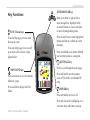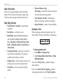
1
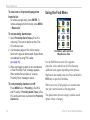
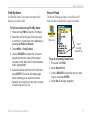
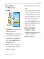
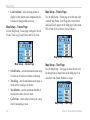
Owner’s Manual eTrex HC series ® personal navigator (eTrex Vista HCx shown) © 2007 Garmin Ltd. or its subsidiaries Garmin International, Inc. 1200 East 151st Street, Olathe, Kansas 66062, USA Tel. (913) 397.8200 or (800) 800.1020 Fax (913) 397.8282 Garmin (Europe) Ltd. Liberty House Hounsdown Business Park, Southampton, Hampshire, SO40 9RB UK Tel.+44 (0) 870.8501241 (outside the UK) 0808 2380000 (within the UK) Fax+44 (0) 870.8501251 Garmin Corporation No. 68, Jangshu 2nd Road, Shijr, Taipei County, Taiwan Tel. 886/2.2642.9199 Fax 886/2.2642.9099 All rights reserved. Except as expressly provided herein, no part of this manual may be reproduced, copied, transmitted, disseminated, downloaded or stored in any storage medium, for any purpose without the express prior written consent of Garmin. Garmin hereby grants permission to download a single copy of this manual onto a hard drive or other electronic storage medium to be viewed and to print one copy of this manual or of any revision hereto, provided that such electronic or printed copy of this manual must contain the complete text of this copyright notice and provided further that any unauthorized commercial distribution of this manual or any revision hereto is strictly prohibited. Information in this document is subject to change without notice. Garmin reserves the right to change or improve its products and to make changes in the content without obligation to notify any person or organization of such changes or improvements. Visit the Garmin Web site (www.garmin.com) for current updates and supplemental information concerning the use and operation of this and other Garmin products. Garmin® is a trademark of Garmin Ltd. or its subsidiaries, registered in the USA and other countries. Garmin Mobile™, myGarmin™ eTrex®, AutoLocate®, TracBack®, BlueChart®, and MapSource® are trademarks of Garmin Ltd. or its subsidiaries. These trademarks may not be used without the express permission of Garmin. microSD™ is a trademark of The SD Card Association. TransFlash™ is a trademark of SanDisk Corporation. Other trademarks are those of their respective owners. July 2007 Part Number 190-00817-00 Rev. B Printed in Taiwan Introduction Introduction Thank you for choosing the Garmin® eTrex Vista® HCx, eTrex Legend® HCx, eTrex Summit® HC, or eTrex Venture® HC. These units use the proven performance of Garmin high-sensitivity GPS and fullfeatured mapping to create an unsurpassed portable GPS receiver. The eTrex models operate identically with a few exceptions. If a feature is discussed in this manual that is not universal for all HC series units, a notation is made. Take a moment to compare the contents of this package with the packing list on the box. If any pieces are missing, contact your Garmin dealer immediately. Tips and Shortcuts • To quickly return to the Main Menu from any page, press the MENU key twice. • To extend battery life, turn off the GPS when not using the eTrex for navigation. Decrease the level of the display’s backlight by quickly pressing and releasing the POWER key. Product Registration Help us better support you by completing our online registration today! Connect to our Web site at http://my.garmin.com. Keep the original sales receipt, or a photocopy, in a safe place. Contact Garmin Contact Garmin if you have any questions while using your eTrex. In the USA contact Garmin Product Support by phone: (913) 397-8200 or (800) 800-1020, Monday–Friday, 8 AM–5 PM Central Time; or go to www.garmin.com/support/, and click Product Support. In Europe, contact Garmin (Europe) Ltd. at +44 (0) 870.8501241 (outside the UK) or 0808 2380000 (within the UK). Optional �Accessories ����������� For a complete list of available accessories and maps for use with the eTrex, refer to http://buy.garmin.com. WARNING: See the Important Safety and Product Information sheet in the product box for product warnings and other important information. eTrex HC series Owner’s Manual Introduction Table of Contents Introduction.........................................................i Tips and Shortcuts................................................i Product Registration.............................................i Optional Accessories............................................i Getting Started...................................................1 Installing Batteries and Lanyard.........................1 Operating the eTrex..............................................2 Key Functions............................................................ 3 Turning on the eTrex............................................4 Adjusting the Backlight.......................................4 Initializing the GPS Receiver...............................4 Basic Operation.................................................7 Creating and Using Waypoints...........................7 Proximity Waypoints............................................9 Using the Find Menu......................................... 10 Using Tracks...................................................... 16 Creating a Route................................................ 20 Main Menu.......................................................... 36 Tracks................................................................. 36 Routes Page....................................................... 36 Highway Page.................................................... 36 Setup Menu........................................................ 37 Proximity Waypoints......................................... 43 Calendar............................................................. 43 Calculator........................................................... 44 Stopwatch.......................................................... 44 Sun and Moon.................................................... 44 Hunt & Fish........................................................ 44 Games Menu...................................................... 44 Appendix..........................................................45 Specifications.................................................... 45 Software License Agreement........................... 47 Declaration of Conformity................................ 47 Index.................................................................48 Main Pages.......................................................23 Satellite Page..................................................... 24 Map Page............................................................ 24 Compass Page................................................... 27 Altimeter Page................................................... 32 Trip Computer Page.......................................... 35 ii eTrex HC series Owner’s Manual Getting Started Getting Started Installing Batteries and Lanyard The eTrex operates on two AA batteries (not included). Use Alkaline, NiMH, or Lithium batteries. See page 37 for setting the battery type. To install the batteries: 1. Place the loop of the lanyard through the slot at the base of the unit. 2. Route the strap through the loop, and pull tight. Optional belt clip (attaches to belt or waistband) USB connector port (under weather cap) PUSH TO EJECT 1. Remove the battery cover by turning the locking ring 1/4 turn counter-clockwise and pulling the cover loose. 2. Insert the batteries, observing the proper Locking pin slot polarity. To install the lanyard: Battery compartment Remove the batteries when you do not plan to use the unit for several months. Stored data is not lost when batteries are removed. eTrex HC series Owner’s Manual Belt clip knob Lanyard installation Auxiliary mount adapter (Do not discard. This adapter attaches to the unit for connection to mounting kits.) Getting Started Operating the eTrex Understanding Terms Select—move the highlighted area on the screen up, down, left, or right with the ENTER/ROCKER key to select individual fields. Highlighted field Field Key—when you are directed to press a key, press and quickly release the key. Field—the location on a page where data or an option can be shown or entered. On-screen button—use the ENTER/ROCKER key to select a button, and press it in to ENTER. Scroll bar—when viewing a list of items too long to appear on the screen, a scroll bar appears next to the list. To scroll through a list, press up or down on the ROCKER, or use the In and Out keys. Default—the factory setting saved in the unit’s memory. You can change the settings, and revert to the factory settings when you select Restore Defaults. On-screen buttons Manual Conventions In this manual, when you are instructed to select an item, small arrows (>) appear in the text. They indicate that you should highlight a series of items on the screen using the ROCKER, and press in to ENTER after each item. For example, if you see “select Service > Show Info,” you should highlight Service, and press ENTER. Then highlight Show Info, and press ENTER again. eTrex HC series Owner’s Manual Getting Started Key Functions IN/OUT Zoom keys From the Map page, press to zoom the map in or out. From any other page, press to scroll up or down a list or move a highlighted slider. ENTER/ROCKER key Rock up or down or right or left to move through lists; highlight fields, on-screen buttons, or icons; enter data; or move the map panning arrow. Press in and release to enter highlighted options and data or confirm on-screen messages. Press in and hold at any time to MARK your current location as a waypoint. QUIT/PAGE key MENU/FIND key Press and release to view the Options Menu for a page. Press and hold to display the Find Menu. Press to cycle through the main pages. Press and hold to turn the compass on or off (Vista HCx and Summit HC only). POWER key Press and hold to turn on or off. Press and release for backlighting or to view time, date, and battery capacity. eTrex HC series Owner’s Manual Getting Started Turning on the eTrex To turn the eTrex on and off: Press and hold POWER. Adjusting the Backlight To adjust the backlight level: 1. Press and quickly release the POWER key. 2. Press up on the ROCKER to increase the brightness and down to decrease. 3. Press ENTER or QUIT to close. Initializing the GPS Receiver The first time you turn on your eTrex, the GPS receiver must collect satellite data and establish its current location. To receive satellite signals, you must be outdoors and have a clear view of the sky. To initialize your eTrex: Hold the unit in front of you facing the sky. While the GPS receiver is searching for the satellite signals, a “Locating Satellites” message is replaced by an “Acquiring Satellites” message until enough signals are acquired to fix its location. The outer circle represents the horizon. The inner circle is a location 45 degrees from the horizon. The number of each overhead satellite is shown. The strength of each satellite signal is shown. If the unit cannot establish a satellite fix, a list of solutions appears. Highlight the appropriate solution, and press ENTER. eTrex HC series Owner’s Manual Getting Started The Status Bar and Date and Time The Status Bar and Date/Time Window appear below the backlight adjustment slider when you press and release POWER. Status Bar - Date/Time Window Power to the unit is provided by batteries or from an auxiliary source. Power status is shown on the Main Menu and the Status Bar. The Battery Power icon shows the remaining power as the battery is depleted. The external power icon is shown when the unit is powered externally. Satellite signal status is shown when searching for or acquiring satellites , a 2D fix is attained and a 3D fix is attained. The Electronic Compass (Vista HCx and Summit HC only) appears when activated. Using the Mapping Databases Many of the eTrex features require detailed mapping data to be fully operational, so you need to transfer maps before using the unit. The eTrex Vista HCx and Legend HCx are equipped with a slot for a microSD™ card (user provided) that can be loaded with detailed maps from optional MapSource disks. With selected MapSource mapping data, you can view listings of nearby restaurants, lodging, shopping centers, attractions and entertainment, and addresses. The amount of data transferable is 24 MB for the eTrex Summit HC and Venture HC, for the eTrex Vista HCx and Legend HCx it is determined by the size of the microSD card. Use the USB Interface Cable, provided with the unit, to transfer MapSource data from a computer to the microSD card when installed in the eTrex. Purchase additional microSD cards at your local electronics supplier, or see the Garmin Web site: www.garmin.com for compatible MapSource products and pre-loaded microSD cards. eTrex HC series Owner’s Manual Getting Started Transferring Data to a microSD™ Card The eTrex Vista HCx and Legend HCx are equipped with a microSD data card slot. To install a microSD card: microSD card location PUSH TO EJECT 1. Remove the battery compartment cover from the back of the unit. 2. Locate the card slot at the upper-left edge of the battery tray, and slide the card into the slot. USB port weather cover 3. Press down on the card and release quickly to eject it from the slot and remove it from the eTrex. USB port Contacts on card must face away from the batteries. an 1. Lift the weather cover from the USB port on the back of the unit. 2. Connect the USB cable to the USB port on your computer and to the mini-USB port on the back of the unit. 3. Follow instructions for selecting and downloading maps provided with the MapSource map data disk. Accessing the microSD card slot Taiw To transfer map data to a microSD card: Battery compartment with cover removed PUS H TO EJE CT microSD card inserted in card slot Installing and removing the microSD card Accessing the USB port eTrex HC series Owner’s Manual Basic Operation Basic Operation This section explains some of the more common operations you can perform with your eTrex, including creating and using waypoints, using the Find Menu, and how to create and use tracks and routes. Creating and Using Waypoints Waypoints are locations or landmarks you record and store in your GPS. You can add waypoints to routes and even create a Go To directly to the selected waypoint. You can create waypoints using three methods. Press ENTER while at a location, create a waypoint on the Map page, or enter coordinates for a waypoint manually. Marking Your Current Location Press in and hold the ROCKER to quickly mark your current location creating a new waypoint. You must have a valid position (2D or 3D) fix to mark your current location. eTrex HC series Owner’s Manual Waypoint symbol Waypoint name Mark Waypoint Page To mark your current location: 1. Press and hold the ROCKER (MARK) until the Mark Waypoint page appears. A default threedigit name and symbol are assigned to the new waypoint. 2. To accept the waypoint with the default information, highlight OK. OR To change any information, select the appropriate field, and press ENTER to open the on-screen keypad. After entering and confirming your changes, select OK. Basic Operation Creating Waypoints Using the Map To create a waypoint using the Map page: 1. On the Map page, use the ROCKER to move the pointer to the map item you want to mark. 2. Press in and quickly release the ROCKER to capture the pointer location and open the information page for the map item. 3. Select Save. If there is no information for that point, a “No map information at this point. Do you want to create a user waypoint here?” prompt appears. Select Yes. Editing Waypoints You can edit waypoints to change the symbol, name, note, location, and elevation. To edit a waypoint: To delete a waypoint: From the the Waypoints page, select the waypoint you want to delete > Delete. Note: When you delete a waypoint, you cannot recover it from the unit. To move a waypoint on the Map Page: 1. Press FIND > Waypoints. 2. Select the waypoint you want to move, and press ENTER. 3. Select Map to show the waypoint on the map. 4. Press ENTER to place a MOVE marker next to the waypoint. 5. Use the ROCKER to move the waypoint to a new location, and press ENTER. 1. Press and hold FIND. 2. Select Waypoints. 3. Select the waypoint you want to edit, and press Enter. 4. Make changes by highlighting each field. Use the waypoint symbol chart and alphanumeric keypad to enter new data. eTrex HC series Owner’s Manual Basic Operation To calculate a location by averaging: 1. Find a location that you want to calculate an average for, press MARK > Avg to begin averaging. 2. Press Save. Proximity Waypoints Use the Proximity Waypoints page to define an alarm circle around a waypoint. (HCx version shown.) Projecting a Waypoint Create a new waypoint by projecting the distance and a bearing from one location to a new location. To project a waypoint: 1. Press FIND > Waypoints. 2. Select the waypoint you want to project. The Waypoint Information page opens. 3. Press MENU > Project Waypoint to open the Project Waypoint page. 4. Enter the distance and bearing to the projected waypoint in the appropriate fields, and press QUIT when finished. eTrex HC series Owner’s Manual Proximity Waypoints Page To add a proximity waypoint: 1. Press MENU twice > Proximity. 2. Select an empty line, and press ENTER. 3. Select a waypoint from the Waypoints List or from any other group of Find items to open the information page for the item. 4. Select Use to add the point to the list on the Proximity Waypoints page. 5. Using the ROCKER, select the Radius field and enter a value. Basic Operation To clear one or all proximity waypoints from the list: Using the Find Menu To remove a single entry, press ENTER. To remove all waypoints from the list, press MENU > Remove All. To set proximity alarm tones: 1. Select Proximity Alarm Tones (eTrex HCx units only). The tone for alarms on the eTrex HC units is pre-set. 2. Use the setup page on HCx units to assign tones to the types of alarms listed. Speed Alerts are obtained by using POI Loader. (see page 16). 3. When you trigger an alarm, a tone sounds and a “Near Proximity Point” message appears. When outside the set radius, a “Leaving Proximity Point” message is shown. To turn proximity alarms on or off: Press MENU twice > Proximity (eTrex HCx and HC units) > Proximity Alarm Tones (eTrex HCx units) and check or uncheck the Proximity Alarms box. 10 Find Menu with optional MapSource data Use the Find Menu to search for waypoints, geocaches, cities, and exits in the eTrex basemap. Additional icons appear depending on the optional MapSource data loaded to the unit. Press and hold the FIND key to open the Find Menu. When you access a Find group list, it contains items near your current location or the map pointer. The options menu for each category contains search options. Select a Category. eTrex HC series Owner’s Manual Basic Operation Find By Name Use Find By Name, if you know the name of the location you want to find. Recent Finds The Recent Finds page shows a list of the last 50 items you have searched for or gone to recently. To find a location using Find By Name: 1. Press and hold FIND to open the Find Menu. 2. Select the icon for the type of item you want to search for, or search the entire database by selecting All Points of Interest. 3. Press MENU > Find By Name. 4. Use the ROCKER to operate the on-screen keypad and enter the name of the location you want to find. When the Find list contains a match, highlight OK. 5. Select the location item from the Find list and press ENTER. The item’s information page opens, allowing you to save the item as a waypoint, show the item on the map, or create a route to the item (Go To). Recent Finds icon List of recently found items To go to a recently found item: 1. Press and hold FIND. 2. Select Recent Find. 3. Use the ROCKER to select the item you want to go to, and press ENTER. 4. Select Go To to begin navigation. eTrex HC series Owner’s Manual11 Basic Operation Using the Find Item Information Page When you select an item from the Find item list and press Enter, detailed information about the item is shown. Each information page contains three onscreen buttons. Different buttons appear depending on whether you are selecting a Find item to navigate to, or adding a Find item to a route list as a waypoint. Find Information Page Options Menu To use the Options Menu: 1. With an information page open for a Find item, press MENU to open the Options Menu. 2. Use the ROCKER to select an option: • Average Location—sample a new waypoint location over time, and average the result for a more accurate location reference. See page 9. • Project Waypoint—create a new waypoint referencing another location by entering bearing and distance from the referenced location. See page 9. • Find Near Here—return to the Find Menu to search for map items near the item. 12 • Change Reference—point to a new location on the Map page using the pointer. • Set Proximity—program an alarm to sound when you are within a specified radius of an item. • Add To Route—include this item on a new route or add it to an existing route. See page 20. • View Sun and Moon—view Sun and Moon tables for this item’s location. See page 44. • View Hunt and Fish—view Hunt and Fish tables for this item’s location. See page 44. • Map Information—show the map from which the map item originated. See page 6 for information about downloading detailed maps. eTrex HC series Owner’s Manual Basic Operation To find an item near another item: 1. Press and hold FIND. 2. Select a category. 3. Select an item from the Find list. 4. Press MENU, select Find Near Here. The Find Menu opens with each category containing items near the item selected. 5. Select a category icon, and press ENTER to open a Find list of items near the item. To find an item from another location on the map: 1. Press and hold FIND. 2. Select an icon on the Find Menu. 3. Press MENU, select Change Reference. The Map page appears. 4. Use the ROCKER to pan the arrow (pointer) to the map location you want. The Find list shows a list of items near the new map location. Finding a Waypoint The Waypoints page contains a list of all saved waypoints. Waypoints are stored in alphanumeric order and are identified by an assigned symbol. To find a waypoint: 1. Press and hold FIND. 2. Select Waypoints and choose a waypoint. Waypoints icon Finding a Geocache Select Geocache to view the list of geocache locations created by you or downloaded from your computer. A geocache location is a waypoint with a geocache symbol to separate it from others. For more information about geocaching, log on to http://my.garmin.com, and click “Go Geocaching.” eTrex HC series Owner’s Manual13 Basic Operation To find a geocache: 1. Press and hold FIND. 2. Highlight Geocache. You can view found geocaches or those that have not been found. 3. Use the ROCKER to highlight a geocache on the list. 4. Select Go To to navigate to the geocache location. When navigating to a geocache, the Compass page changes to Geocache Navigation mode and any additional information about the downloaded cache location is shown in the comment field. When a geocache is found, the unit marks the cache as found, logs an entry into the calendar, and provides an option that shows the nearest cache. Finding a City Select Cities from the Find Menu to find any city listed in the mapping data. To find a city: 1. Press and hold FIND. 2. Select Cities. The Cities page shows a list of cities near your current location. 3. Select a city from the list, and press ENTER. OR If the city you want is not listed, press MENU > select a search method. Finding an Interstate Exit Use the Exits icon on the Find Menu to find an interstate exit. To find an interstate exit: 1. Press and hold FIND. 2. Select Exits. A list of interstate exits near your location is shown. 14 eTrex HC series Owner’s Manual Basic Operation 3. Use the ROCKER to select an exit, and press ENTER. This page contains the exit description, a list of available services near the exit, and the distance and bearing from the exit to the highlighted service. 4. Select a service from the list, and press ENTER. Finding an Address If you downloaded detailed mapping data, use the Addresses icon on the Find Menu to find an address. When you enter the street number, street name, and city, the find feature matches that data with addresses in the map database. Addresses icon To find an address: 1. Press and hold FIND. 2. Select Addresses. NOTE: If your unit has a GPS fix, the <Enter Region> field is populated with your current region. You do not have to specify a city in the <Enter City>, because the database has information for the entire region. 3. Select the <Enter Number> field and type the street number using the on-screen keypad. Select OK. 4 Select the <Enter Street Name> field. The street list opens. 5. Use the on-screen keypad to enter the street name. Select OK. A list of matches appears. 6. Select the address. Finding an Intersection Addresses Page This feature also requires detailed mapping data. Follow the basic steps for finding an address when searching for an intersection. eTrex HC series Owner’s Manual15 Basic Operation Searching for a Point of Interest If you downloaded MapSource detailed mapping, you can use the All Points of Interest category on the Find Menu to locate a nearby restaurant, lodging, landmark, public building, or select a category. To find a point of interest: 1. Press and hold FIND. 2. Select All Points of Interest to show a list of all points near your current location. 3. Press MENU. 4. Select an item from the list, and press ENTER. POI Loader and Custom Points of Interest You can create your own category for points of interest by using the Garmin POI Loader utility for HCx units, downloadable from the Garmin Web site: www.garmin.com/products/poiloader/. Follow the Help instructions to use POI Loader. 16 Using Tracks The Tracks feature creates an electronic bread crumb trail, or “track log,” on the Map page as you travel. The track log contains information about points along its path. The track log starts recording as soon as the unit gets a location fix. The percentage of memory used by the current track log appears at the top of the Tracks page. Percentage of memory used List of saved tracks Tracks Page To clear the track log: 1. Press MENU twice to open the Main Menu. 2. Select Tracks. 3. Select the Clear button. A confirmation message appears. eTrex HC series Owner’s Manual Basic Operation To set up a track log: 1. Press MENU twice > Tracks. 2. Select Setup. Data card option (HCx units only) • Wrap When Full—the track log records over the oldest data with new data. • Record Method—distance records track points after a specified distance is traveled. Time creates track points after a specified time has elapsed. Auto (recommended) allows you to choose from five intervals. • Interval—records a track according to the Record Method and Interval. Enter a specific distance, time, or frequency. • Color—select the color of the active track on the map. • Log Track to Data Card—(HCx units only) records the current track log to the microSD card, in addition to the unit’s internal memory. Using this option allows you to record a large number of track points (depending on the capacity of the microSD card). Track logs on the data card are .gpx GPS position data files, and are not used by your unit. To save the entire track log: 1. Press MENU twice > Tracks. 2 Select Save. A message appears asking you if you want to save the entire track. 3. Select Yes to save the track. eTrex HC series Owner’s Manual17 Basic Operation Track name Track distance Calculated area Track color Saved Track Page To save a portion of the track log: 1. Press MENU twice > Tracks. 2. Select Save. 3. Select No to save only a portion of the track log. 4. Use the ROCKER to move the pointer to the point on the track line that you want to be the beginning point, and press ENTER. 5. Repeat to select an ending point. Select OK. 18 To log tracks to an HCx unit microSD card: 1. With the Track Log Setup page shown, select Data Card Setup. 2. Highlight the Log Track to Data Card option, and then press ENTER. A current date .gpx file appears in the Data Card Tracks list. This file is a continuous compilation of all track data for the indicated date. As long as this feature is enabled, a new file is recorded for each day you use the unit. Recording continues until the card is filled. 3. Use the USB cable to connect the unit to your computer, then access the USB Mass Storage feature explained on page 38. Open the track logs using Garmin MapSource or another .gpx file-compatible application. 4. To delete these track logs from the microSD card, highlight individual logs, and then press ENTER. Note: Do not remove the microSD card from the unit while logging a track or corruption of the data can result. eTrex HC series Owner’s Manual Basic Operation To view a track on the map: On the Saved Track page, select Map. A map showing the entire track appears. Begin and End markers and waypoints are added to the track. Track Profiles A Track Elevation Profile is created from elevation readings when using the eTrex Summit HC or the eTrex Vista HCx. All units show profiles, if using Digital Elevation Model (DEM) maps. Refer to the Garmin Web site for information about these maps. To view a track profile: Saved track on the Map page To calculate the area of a track: 1. With the Track Log page open and the Track Log on, press MENU. 2. Select Area Calculation, and press ENTER. 3. Press Enter to start the area calculation. As you move and define the area’s boundaries, a Stop button appears on the page. 4. When finished defining the area, press ENTER, and select Save. 1. Open the Saved Track page, and press MENU. 2. Select Profile. The beginning of the track is marked by a flag. Use the ROCKER to scroll across the track profile. At any point along the profile, press ENTER to show it on the map. 3. Press MENU to use Zoom Ranges and Hide Symbols options. Elevation Begin marker Distance from begin and end points End marker Track Profile Page eTrex HC series Owner’s Manual19 Basic Operation Navigating a Saved Track To use the TracBack feature: 1. With the Saved Tracks page for the track or the Track Log open, select TracBack, to show the track. Select the point to TracBack. 2. Use the ROCKER to move the pointer to the point on the map to start navigating the TracBack. 3. Select Follow Road (HCx units with detailed maps only) to route back to the point using available roadways, or select Follow Track to retrace your original path of travel. The Map page gives directions to the first turn on the track. 4. Move in the direction of the first turn. At the first turn, directions to each turn are shown. 5. Select Menu > Stop Navigation to exit. To create a waypoint on a saved track: 1. With a saved track on the map, use the ROCKER to move the pointer on the track point that you want to mark as a user waypoint. 2. Press and hold ENTER. 20 Creating a Route Routing creates a sequence of waypoints that lead you to your final destination. The eTrex stores 50 routes with up to 250 points each. Create or modify a route using the Routes page, and add waypoints to a route. Create complex routes using MapSource mapping. Route Page Route on the Map Page To create a route: 1. Press MENU twice > Routes. 2. Select New > <Select Next Point>. 3. Use the Find Menu to select a route waypoint from one of the Find groups. 4. Select Use to add it to the route. 5. Select Navigate. eTrex HC series Owner’s Manual Basic Operation Methods for routing you to a destination • If you select Go To on the Waypoint page, or for other Find items, a straight path is created. • If you select Navigate when on a Route page, the eTrex uses a route made of waypoints or Find Menu items. It navigates directly from point to point. • When using an eTrex HCx unit, both navigation methods change when you select the Follow Roads option on the Routing Setup page. Both Go To navigation and point-to-point allow you to Auto-route using roads. Auto-routing uses roadways in the map database to automatically calculate a route to your destination. Turns on roadways are preceded by a guidance message with a graphic of the turn. Using Auto-Routing (Auto-Routing is a feature available only with the eTrex Vista HCx and Legend HCx.) This feature is enabled when using City Navigator® mapping data. When you select a destination, and select Go To, you are queried, “Follow Road” or “Off Road.” Using Follow Roads increases the number of turns and shows an Active Route page. Select Off Road to view only a list of route points. A “Calculating Route” message appears until the route calculation is complete. Your route appears as a magenta line overlaying the map. Navigating a Route To navigate a saved route: 1. Press MENU twice > Routes. 2. Select a saved route > Navigate. 3. To stop navigating, press MENU > Stop Navigation. Route on Map Page eTrex HC series Owner’s Manual21 Basic Operation To preview the turns for an active route: 1. From the Routes page, select a saved route. 2. Select Navigate to begin navigation. 3. Press QUIT to view the list of turns on the route. To view an individual turn, select it. 4. Use the ROCKER to scroll through all turns. 2. Select a saved route > select the route name field at the top of the Route page. To review individual route points: 1. Press MENU twice > Routes. 2 Select a saved route > select a point on the Route page > ENTER > Review. 3. Select Save, Map, or Go To. To delete a route: From the page for that route press MENU > Delete Route. To select the off-road transition for a route: 1. Press MENU twice > Routes > Menu. Active Route Page when following roads Turn Preview Page Editing a Route Use the Route page to edit, change the route name, and review route points. To change the name of the route: 2. Select Off Road Transition > Route Leg Transition. 3. Select (Manual or Distance) when advancing to the next point. Select Distance to enter a radius, so that when within the entered distance, you are lead to the next point. Select Manual to transition to the next point anytime while navigating a route. 1. Press MENU twice > Routes. 22 eTrex HC series Owner’s Manual Main Pages Main Pages The eTrex Vista HCx and Summit HC has four main pages: Map page, Compass page, Altimeter page, and the Main Menu. The eTrex Legend HCx and Venture HC do not have the Altimeter page. Cycle through these pages by pressing QUIT. Add additional pages by using the page sequence option on the Main Menu. The Active Route page appears in the sequence when you are actively navigating a route. The Satellite page appears only at start up. Each page has an options menu. To view the options menu for a page, press MENU. Map Page Compass Page Altimeter Page Main Menu No Options Map Page Options Menu Compass Page Options Menu Altimeter Page Options Menu eTrex HC series Owner’s Manual23 Main Pages Satellite Page This page appears when you turn the unit on and is accessed from the Main Menu thereafter. Satellite Page Options • Use With GPS Off/On—enables you to turn the GPS receiver on or off. • Track Up/North Up—indicates whether satellites are shown with the rings oriented with North toward the top of the display or your current track toward the top of the screen. • Multicolor/Single Color—indicates whether each satellite appears as a different color. • New Location—use if you have moved the unit more than 600 miles (1,000 km). • GPS Elevation—shows your current elevation. Map Page A built-in basemap that includes cities, interstates, state and county highways, exit information, and lake and river outlines is shown on this page. Increased road detail, points of interest and mapping data is added when using MapSource detailed mapping data. Data fields Show menu Map Page with data fields Two map operating modes, position mode and pan mode, determine what is shown on the map display. 24 eTrex HC series Owner’s Manual Main Pages Position mode pans the map to keep your present location in the display area. The position marker shows your travel on the Map page. When you press the ROCKER, the eTrex enters pan mode, which moves the map to keep the white arrow (map pointer) within the display area. Add and configure up to four optional data fields at the top of the page to provide a varity of travel and navigational information. To show data fields on the Map Page: 1. Press MENU > Data Fields. The Show submenu appears. 2. Select the number of data fields you want to show on the Map page, and press ENTER. To change a data field display: 1. Press MENU > Change Data Fields. The first data field is highlighted. 2. Press ENTER. 3. Select an option. 4. Move to the next field, and repeat. Using Additional Map Data View listings of nearby restaurants, lodging, shopping centers, attractions and entertainment, and retrieve addresses and phone numbers for any listed location when using optional MapSource data disks and preprogrammed microSD cards. To review map information: 1. From the Map page, press MENU > Setup Map. 2. Select the Map Setup-information page. The list of maps stored appears. A check mark means the map is shown on the Map page. Changing the Zoom Range Press the In key to decrease the zoom range and show an area with greater detail; press the Out key to increase the range to see a larger area with less detail. The current zoom range setting is shown in the lower-left corner of the Map page. If no further map information is available, “overzoom” appears under the zoom range. When using MapSource maps, “mapsource” appears below the scale. eTrex HC series Owner’s Manual25 Main Pages Map Orientation There are two map orientations in the Setup Map option. North Up orients the map like a paper map. Track Up orients the map in the direction of travel. Map Page Options • Stop (Resume) Navigation—stops/resumes navigation. • Recalculate—recalculates a route. • Data Fields—opens the Show sub-menu so you can select the number of data fields to show: Map Only, 1 Wide Data Field, 2 Data Fields, 2 Wide Data Fields, 3 Data Fields, or 4 Data Fields. • Change Data Fields—allows you to select the type of data in the data fields. This option is available if data fields are selected. • Guidance Text—shows messages on the screen advising you of your next navigation move. • Setup Map—accesses six pages of display options. 26 • Measure Distance (Stop Measuring)—measures the distance from your current location to the map pointer. • Turn Declutter On (Off)—eliminates the display of items that can block road details. • Restore Defaults—returns to factory defaults. Guidance Text When navigating, guidance text appears above the map. Guidance Text gives directions to a destination. Guidance text To show guidance text: 1. Press MENU > Guidance Text. 2. Select Always Show, Never Show, or Show When Navigating. If you select Always Show, a guidance message always appears. If you select Show When Navigating, a guidance message appears until you select Stop Navigation. eTrex HC series Owner’s Manual Main Pages Measuring Distance To measure distance between two points: 1. Press Menu > Measure Distance. An onscreen arrow appears at your location with “REF” below it. 2. Move the arrow to the reference point (the starting point you want to measure from), and press ENTER. A push pin icon marks the starting point. 3. Move the arrow to the point you want to measure. The distance between the two points is shown in the upper-right corner. Compass Page The Compass page guides you to your destination with a graphic compass display and a bearing or course pointer. Bearing pointer The compass ring moves to indicate North orientation. Compass Page The rotating compass ring indicates the direction you are heading. The bearing and course pointers indicate the direction (bearing to or course of travel) to your destination, relative to your current heading direction. Choose a bearing pointer or course pointer for guidance. eTrex HC series Owner’s Manual27 Main Pages Using the Electronic Compass (All of the eTrex HC series units use a GPS data driven compass but only the Vista HCx and Summit HC have an additional electronic compass.) When you press and hold QUIT on these units, the electronic compass turns off and stays off until you press and hold QUIT again. The electronic compass functions like a magnetic compass when you are stationary. When you are moving and reach a pre-set speed, it uses data from the GPS receiver to maintain your heading. When you stop (after a pre-set time), it again operates like a magnetic compass. To turn the electronic compass on or off: 1. Press and hold Quit to turn the electronic compass on or off. The compass icon appears in the status bar when the electronic compass is on. When you are not using the electronic compass, turn it off to conserve batteries. When it is turned off, the unit uses the GPS receiver for navigation. 28 2. Hold the Vista HCx level to get an accurate electronic compass reading. Setting the speed and time for Compass Auto On and Off: 1. Press Menu twice > Setup. 2. Select Heading. 3. Select Switch to compass heading when below.... 4. Use the numeric keypad to enter a speed. 5. Select for more than... to set the time delay from the time options list. Calibrating the Electronic Compass Calibrate the electronic compass outdoors when you first use the Vista HCx or Summit HC. To ensure continued accuracy, calibrate after installing new batteries, after moving more than 100 miles (160 km), or experiencing a temperature change greater than 68º F (20º C) from the last calibration. The accuracy of the electronic compass is also adversely affected if the unit is not held level or you are near objects that affect magnetic fields, such as cars or buildings. eTrex HC series Owner’s Manual Main Pages To calibrate the electronic compass: 1. Press Menu > Calibration. 2. With Start selected, press ENTER, and follow on-screen directions for holding and turning the unit. Hold the unit level and turn slowly. • A Just Right, Too Fast, or Too Slow message appears notifying you to adjust your turning speed. Hold the unit level while turning. • A Calibration Successful message appears when finished. • If a Calibration Failed message appears, repeat the process. 3. Press ENTER to return to the Compass page. Compass Page Options • Sight ‘N Go—navigate to an object within your sight (Vista HCx and Summit HC only). • Stop/Resume Navigation—turns active navigation for a route or Go To on and off. • Recalculate—recalculates the path to a destination. • Course or Bearing Pointer—toggles between the course pointer and the bearing pointer. • Data Fields—selects the number of data fields that appear on the Compass page. • Change Data Fields—selects the type of data you want to show in the data fields. • Calibrate Compass—accesses the compass Calibration page (Vista HCx and Summit HC only). • Restore Defaults—returns to factory settings. eTrex HC series Owner’s Manual29 Main Pages Sight ‘N Go Navigation Sight ‘N Go navigation is available only on the Summit HC and Vista HCx with electronic compass. To use Sight ‘N Go to navigate: 4. Begin traveling to your destination on a course line using the course pointer as a guide. OR Select Project Waypoint. 1. Press MENU > Sight ‘N Go to start the feature. The compass ring with pointer is in-line with the two white sighting marks, one at the base of the screen and one at the top of the screen. Project Waypoint Page Sighting Page 2. Hold the unit at eye level and line up the two sighting marks with the distant object. Press ENTER to lock the direction. 3. Select Set Course. 30 5. Enter an estimated distance from your current location to establish a projected waypoint location. 6. Select Go To to open the Map page and begin navigation to the projected waypoint. The Compass page shows a bearing pointer for guidance. eTrex HC series Owner’s Manual Main Pages Using the Course or Bearing Pointer The bearing pointer and course pointer are independent of each other. The bearing pointer indicates the direction to your destination, and the course pointer indicates your relationship to a course line leading to the destination. If the bearing pointer arrow is pointing straight up, for example, you are going directly to your destination. If it points any direction other than up, turn toward that direction until the arrow is pointing up and then continue in that direction. The bearing pointer points to the destination. If you are using the course pointer option, and you drift away from the line of travel from your original location to your destination, the course deviation indicator (an arrow with horizontal dotted line) provides graphic indication of drift (right or left) according to the scale shown on the compass ring. Move to the right or left to get back on course. 0.25 mi Scale The course pointer indicates your course of travel from your original location and the distance off course. The bearing pointer always indicates the direction to your destination from your current location. eTrex HC series Owner’s Manual31 Main Pages Altimeter Page (The Altimeter page is provided with the Vista HCx and Summit HC only.) The Altimeter page shows you a profile of elevation changes over distance or time, or a profile of pressure changes over time. Selectable data fields Range grid measurement scale Elevation profile Current elevation Rate of ascent and descent Altimeter Page Configure the profile field in the center of the page to show either elevation or ambient pressure plots. Data fields at the top of the page are user selectable. 32 Altimeter Page Options • View Elevation Plot—Over Time or Over Distance—view over a set period of time or over a set distance. • View Pressure Plot—Barometer or Ambient Pressure—view a plot of elevation changes that occur over a set distance or view changes in barometric pressure for a set period of time. • Zoom Ranges—set the Zoom Ranges for elevation, distance, or time when you show the View Elevation Plot. Customize the View option displays using the Zoom Ranges option. • Change Data Fields—select the type of data you want to show in the data fields. • Reset—reset the elevation data and the maximum elevation data. • Calibrate Altimeter—if you know the correct elevation for your location, increase accuracy by using the Calibrate Altimeter option. • Restore Defaults—clears recorded data from the page and begin recording new data. eTrex HC series Owner’s Manual Main Pages Plot Over Time or Distance These two measurement options (changes over a set period of time or changes over a set distance) apply only to the View Elevation Plot option. View Pressure Plot is measured by time. Elevation Over Distance plot 2. Adjust the time and distance measurement using the elevation plot Zoom Ranges option. 3. To clear the plot, clear the Track Log. Adjusting the Zoom Ranges Set the zoom ranges for elevation, distance, or time when you use the View Elevation Plot. Pressure Over Time Plot View Pressure or Elevation Plots Select the View Elevation Plot to plot elevation. Select View Pressure Plot to barometric pressure. To view elevation or pressure plots: 1. Select the option you want from the Altimeter options menu to show the plot. Zoom Range Selection To adjust zoom ranges: 1. Select the type of plot you want to show and use the Rocker to select Zoom Ranges. 2. Move the Rocker up or down to adjust the vertical distance, and left or right to adjust the time or distance. Press ENTER to return. eTrex HC series Owner’s Manual33 Main Pages View Points Scroll through a recorded elevation or pressure profile to view the elevation or pressure, time of day, and date the point was created. Red crosshairs View Points on Map View the location of points on the Map page. To view altitude points on the Map Page: 1. With the Altimeter page open, use the ROCKER to move the crosshairs to the point. 2. Press ENTER to show the point on the map. Resetting Data To reset the elevation data and max elevation fields: View point for an altitude plot View point for a pressure plot 1. Press MENU > Reset. 2. Select the reset options, and press ENTER to place a check by an option. To use the View Points option: 1. Press Menu > View Pressure Plot or View Elevation Plot to open the Plot page. 2. Use the ROCKER to scroll the cross hairs across the profile. As the cross hairs move across the profile, the status window at the bottom of the page changes to show the date, time, and altitude or pressure for the point. 34 Reset Page eTrex HC series Owner’s Manual Main Pages 3. Highlight Apply, and press ENTER to reset the data fields. A confirmation message appears. Calibrating the Altimeter Because the altimeter relies on the barometric pressure to determine the elevation and the pressure at any given elevation can fluctuate, calibrate the altimeter to increase its accuracy. Trip Computer Page The Trip Computer page shows eight types of navigation data. Choosing Big Numbers arranges the page in three large data fields. To manually calibrate the altimeter: 1. Press Menu > Calibrate Altimeter. 2. At the message “Do You Know The Correct Elevation?” select Yes. If you do not know the elevation, select No to use the pressure option. If you do not know the pressure, select No to use the default GPS elevation. 3. Use the ROCKER to enter the new elevation or pressure. Select OK. Trip Computer Page Each data field is selectable and can contain one of many data information options. When the data field title is selected, press ENTER to make a new choice. Trip Computer Page Options The option menu allows you to reset the Trip Computer data when you are ready to start a new trip, choose between Big or Small Numbers, and Restore Defaults. eTrex HC series Owner’s Manual35 Main Pages Main Menu The Main Menu contains settings and features not found on the main pages and sub-menus. The time and date are shown at the bottom of this page. The Main Menu is accessible from any page by pressing MENU twice. To select an item on the Main Menu, highlight the menu item, and press ENTER. Main Menu 36 NOTE: If a page is added to the Main Page sequence, the icon for that page does not appear on the Main Menu. Tracks For more information, see page 16. Routes Page For more information, see page 20. Highway Page Highway Page The Highway page takes you point by point to your final destination. To navigate using the Highway page: While navigating, select Highway from the Main Menu, and observe your path of travel displayed on the highway graphic. eTrex HC series Owner’s Manual Main Pages Setup Menu To access the Setup Menu: From the Main Menu, select Setup. System Setup Page To access the System Setup page: From the Setup Menu, select System. • GPS—choose one of the GPS options other than Normal to save battery power. • WAAS/EGNOS—set Enable or Disable WAAS /EGNOS. • Battery Type—set the Battery Type for more accurate battery capacity status. • External Power Lost—set the unit to turn off if external power is lost. • Proximity Alarms—turn Proximity Alarms on and off (eTrex HCx units only). Use the option menu to restore defaults, or view the version of unit software and the Unit I.D. number. Display Setup Page You can choose a display mode, a color scheme for day and for night viewing, adjust the amount of time that the backlight stays on, and set the level of brightness. To access the Display Setup page: From the Setup Menu, select Display. • Display Mode—set for Auto (changes from day to night mode and back again at dusk and dawn), Day only, or Night only. • Daytime/Nightime Color Scheme Selection— set in Day and Night modes to one of 10 color schemes. • Backlight Timeout—choose from Stays On or delays of 15 seconds, 30 seconds, one minute, or two minutes. • Backlight Level—use the slider to adjust the brightness. eTrex HC series Owner’s Manual37 Main Pages Interface Setup Page Use when connecting to a computer. To access the Interface Setup page: From the Setup Menu, select Interface. The available interface format is Garmin—the proprietary format used to exchange waypoint, track, and map data with a computer. To activate �USB Mass Storage for HCx units: Note: If you have several network drives mapped to your computer, log on without connecting to the network or click Start > Settings > Control Panel > Administrative Tools > Computer Management > Storage > Disk Management and remap a drive letter for the storage device. 4. After the transfer, end the USB cable connection. Tones Setup Page 1. Connect the unit to a computer. 2. Select USB Mass Storage, and press Enter. 3. Double click My Computer to observe a new Removable Drive listing. This setup page allows you to select a unique tone for each of the tone applications. (For proximity alarm tones, see page 10.) To view information for the microSD card: Use to add, remove, or reorder any of the Main pages. Press Menu prior to opening the USB Mass Storage page and select Card Info. To transfer files to the microSD card: 1. Double-click the My Computer icon. 2. Browse the computer for the file. 3. For a computer, select the file, Edit > Copy. 38 Page Sequence Setup To move, insert or remove a Main Page: 1. From the Setup Menu select Page Seq. 2. To rearrange a page in the page sequence, select the page > ENTER. Select Move. 3. To insert a new page, select the page you want it inserted before, press ENTER > Insert. eTrex HC series Owner’s Manual Main Pages Map Setup Page Use the Map Setup page to adjust how items are shown on the Map page. To customize the Map Page display: Map Setup – General Page The Map Setup – General page contains the settings for Orientation, Below, Auto Zoom, Detail, and Lock On Road. 1. Press MENU > Setup Map. The top of the page contains icons for each setup page. 2. Use the ROCKER to select a page and to move up and down the feature fields on each page. General Points Information Map Setup – General Page Tracks Text Marine 3. With a Map Setup feature highlighted, press ENTER to show the list of options for that feature. Each page has a sub-menu of general options. To access this menu, press MENU with the preferred setup page displayed. • Orientation—selects how the map is shown. North Up always shows north at the top of the page. Track Up shows your current track toward the top of the page. • Below—sets the map scale at which the Track Up feature displays. All scales above that revert to the North Up map orientation. • Auto Zoom—zooms the map scale to include the beginning and ending points of a route. • Detail—selects the degree of map detail shown. eTrex HC series Owner’s Manual39 Main Pages • Lock On Road—locks the map pointer to display on the nearest road, compensating for variances in map position accuracy. Map Setup – Tracks Page Use the Map Setup –Tracks page settings for Saved Tracks, Track Log, Track Points, and Go To Line. Map Setup – Points Page Use the Map Setup – Points page to set the map scale at which Map Points, User Waypoints, Street Label, and Land Cover appear on the Map page. Select Auto, Off, or from 20 ft to 500 mi (5 m to 800 km). Map Setup – Points Page Map Setup – Tracks Page • Saved Tracks—sets the maximum zoom range at which saved tracks are shown on the map. • Track Log—sets the maximum zoom range at which active track logs are shown. • Track Points—sets the maximum number of track points used to record a track. • Go To Line—selects either a bearing or course line for navigating a track. 40 Map Setup – Text Page Use the Map Setup – Text page to select the text size for descriptions of map items on the Map page. You can select from Small, Medium, or Large. Map Setup – Text Page eTrex HC series Owner’s Manual Main Pages Map Setup – ����������������� Information Page Use the Map Setup – Information page to view a list of downloaded detailed maps such as topographic, marine charts, and maps with auto-routing capability. Highlight a map to show it on the map or turn it off. • Marine Colors—toggles colors on or off. • Spot Soundings—toggles spot soundings on or off. • Light Sectors—select from On, Off, and Auto. • Symbol Set—select the symbol set to use (Auto, GARMIN, NOAA, International). Routing Setup Map Setup – Information Page Press MENU to view options for displaying maps. Map Setup – Marine Page Use the Map Setup – Marine page to customize settings for marine colors, spot soundings, light sectors, and symbol sets. Choose options for guidance and following roads (Vista HCx and Legend HCx only). To setup Routing: From the Setup Menu, select Routing. Geocache Setup See the Garmin web site for information on geocache locations: http://my.garmin.com, and click Go Geocaching. To setup the Geocache feature: Map Setup – Marine Page 1. Access the Setup Menu, select Geocache. 2. Select the symbol fields if you want to assign other symbols. eTrex HC series Owner’s Manual41 Main Pages 3. Select Yes or No for a calendar entry when a geocache is found. Marine Alarms Setup To access the Marine Setup Page: From the Setup Menu, select Marine. • Anchor Drag Alarm—sets an alarm when you exceed a specified drift distance. • Off Course Alarm—sets an alarm to sound when off course. Time Setup. To access the Time Setup page: From the Setup Menu, select Time. • Time Format—choose from 12-hour or 24hour time format. • Time Zone—set to one of the eight US Time Zones or 24 International Time Zones. • Daylight Saving Time—On, Off or Auto. Units Setup To access the Units Setup page: From the Setup Menu, select Units. 42 • Position Format—sets the coordinate system in which a location is shown. • Map Datum—sets the description for geographic location, for mapping and navigation, and is not an actual map in the unit. • Distance/Speed—sets the unit of measurement to show your speed and distance. • Elevation (Vert. Speed)—sets the unit of measurement (Feet (ft/min), Meters (m/min), or Meters (m/sec)). • Depth—select the unit of measurement (Feet, Fathoms, or Meters). • Pressure—sets the unit of measurement (Inches, Millibars, or Hectopascals) to show pressure. Heading Setup Page You can select the type of heading mode. To access the Heading Setup page: From the Setup Menu, select Heading. • Display—choose from Cardinal Letters, Degrees or Mils. eTrex HC series Owner’s Manual Main Pages • North Reference—choose from True, Magnetic, Grid or User options. The following two features apply to the Vista HCx and Summit HC only: • Switch to compass heading when below— enter the selected speed for the unit to switch from using GPS to using the electronic compass for guidance. • for more than…—enter a time limit to switch to the compass. Calibration Setup Page For the Vista HCx and Summit HC only. Refer to page 28 and page 35. Altimeter Setup To setup the Altimeter: 1. From Setup Menu, select Altimeter. 2. Select the Auto Calibration field to select on or off. When on, elevation is corrected by GPS. 3. Select the Barometer Mode field to specify “Variable Elevation” (used when you are moving) or “Fixed Elevation” (used when stationary). Welcome Page Setup Insert a message when you turn the unit on. To setup the Welcome Page: 1. From the Setup Menu, select Welcome Message. 2. Use the on-screen keyboard to begin entering your message in the Welcome Message field. Jumpmaster Setup Jumpmaster is designed for experienced skydivers and is an option for the eTrex Vista HCx and Summit HC only. Refer the Garmin Web site for detailed information about this feature. Go to the Vista HCx or Summit HC page, and select Manuals. Proximity Waypoints Use the Proximity Waypoints page to define an alarm circle around a waypoint. See page 9. eTrex HC series Owner’s Manual43 Main Pages Calendar To access the Calendar: From the Main Menu, select Calendar. Calculator To access the Calculator: From the Main Menu, select Calculator. Stopwatch To access the Stopwatch: From the Main Menu, select Stopwatch. Hunt & Fish To show hunting and fishing predictions for a specified date and location: 1. From the Main Menu, select Hunt & Fish to view the predictions for a different date. Select Date to open the on-screen keypad. 2. To view the predictions for a location, select the Location field. Games Menu To open the Games Menu: From the Main Menu, select Games. Sun and Moon To access the Sun and Moon Page: From the Main Menu, select Sun and Moon to view the Sunrise/Sunset and Moon phases. 44 eTrex HC series Owner’s Manual Appendix Appendix Altimeter:(Vista HCx/Summit HC only) Accuracy; +/- 10 feet, resolution; 1 ft., user calibrated Specifications Physical Size: Power 4.2" H x 2.2" W x 1.2" D Weight: 5.6 ounces (159 g) with batteries installed. Display: 1.3" W x 1.7" H, 256-color, high resolution, transreflective TFT(176 x 220 pixels) backlit. Case: Rugged, fully gasketed, water resistant, IEC-529, IPX7 Temp: 5 to 158°F (-15 to 70° C) * * The temperature rating of the eTrex may exceed the usable range of some batteries. Some batteries can rupture at high temperatures. Performance Receiver: WAAS/EGNOS enabled, high-sensitivity Acquisition Times: (approx.) Hot start- 3 seconds Warm start- 33 seconds Cold start- 39 seconds Update Rate: Antenna: Compass: (Vista HCx/Summit HC only) Accuracy; +/- 5 degrees, resolution; 1 degree, user calibrated 1/second, continuous Built-in patch Source: Two 1.5 volt AA batteries, 12 V DC Adapter Cable, or PC/USB Adapter Battery Life: Up to 25 hours HCx units Up to 14 hours HC units Accuracy GPS: <10 meters (33 feet) 95% typical* * Subject to accuracy degradation to 100m 2DRMS under the U.S. DoD imposed Selective Availability (SA) Program when activated. DGPS: * 3 meters (10 feet) 95% typical* Wide Area Augmentation System (WAAS) accuracy in North America. Velocity: 0.1 meter/sec steady state Interfaces:Garmin Proprietary (USB) Data Storage Life: Indefinite; no memory battery required Map Storage: HCx units -Dependant on the formatted capacity of the microSD card. HC units - 24 MB eTrex HC series Owner’s Manual45 Appendix Connecting Your eTrex to a Computer Connect your eTrex to your computer using the PC/ USB connector cable provided. Note: Fully install the supplied MapSource Trip & Waypoint Manager software on your computer before connecting the USB cable to the computer. Follow the instructions for installation and operation provided with the software. To connect your eTrex to your computer: 1. Lift the USB port protective cover from the back of the eTrex, and insert the smaller connector on the USB cable into the matching port. 2. Connect the remaining cable end to your computer's USB port. Information about USB Drivers The USB drivers are automatically installed when you install the MapSource Trip and Waypoint Manager software that came with your eTrex. When you initially connect the eTrex to a USB port, your computer might prompt you to locate the 46 destination of the drivers for the device. You only need to install the drivers once. After the drivers are installed, your computer always detects your eTrex when it is connected. USB drivers might be updated periodically. Find updates at: www.garmin.com. Transferring Tracks or Waypoints from the eTrex to MapSource on Your Computer Tracks and waypoints saved on your eTrex can be saved and viewed in Garmin MapSource. To transfer: 1. Be certain Garmin MapSource Trip and Waypoint Manager is installed on your computer and open. 2. Click “Receive from Device” from the Transfer menu or click the “Receive from Device” icon at the top of the screen. eTrex HC series Owner’s Manual Appendix Software License Agreement BY USING THE eTrex, YOU AGREE TO BE BOUND BY THE TERMS AND CONDITIONS OF THE FOLLOWING SOFTWARE LICENSE AGREEMENT. PLEASE READ THIS AGREEMENT CAREFULLY. Garmin grants you a limited license to use the software embedded in this device (the “Software”) in binary executable form in the normal operation of the product. Title, ownership rights, and intellectual property rights in and to the Software remain in Garmin. You acknowledge that the Software is the property of Garmin and is protected under the United States of America copyright laws and international copyright treaties. You further acknowledge that the structure, organization, and code of the Software are valuable trade secrets of Garmin and that the Software in source code form remains a valuable trade secret of Garmin. You agree not to decompile, disassemble, modify, reverse assemble, reverse engineer, or reduce to human readable form the Software or any part thereof or create any derivative works based on the Software. You agree not to export or re-export the Software to any country in violation of the export control laws of the United States of America. Declaration of Conformity Hereby, Garmin declares that this product is in compliance with the essential requirements and other relevant provisions of Directive 1999/5/EC. To view the full Declaration of Conformity, see the Garmin Web site for your Garmin product: www.garmin.com/products/etrexVistahcx/, www.garmin.com/products/etrexLegendhcx/, www.garmin.com/products/etrexSummithc/, www.garmin.com/products/etrexVenturehc/. Click Manuals and select Declaration of Conformity. eTrex HC series Owner’s Manual47 Index Index A adjusting the backlight 4 altimeter page pressure/elevation plots 33 view points 34 auto-routing 21 F find B backlight 4 batteries 1 C compass bearing pointer 31 course pointer 31 compass page 27 Course Deviation Indicator (CDI) 31 creating waypoints using the map 8 D data fields 25 E Enter/Rocker key 3 48 a city 14 a geocache 13 an address 15 by name 10 point of interest 16 waypoints 13 H highway page 36 I initializing 4 installing and removing the microSD card 6 installing batteries 1 installing the lanyard 1 K key functions 3 L log track to data card 17 M main pages 23 map page 24 map data 25 measuring distance 27 orientation 26 setup 39 zoom range 25 mapping databases 5 marking a location 7 P T tracks 16 saving a track log 17 setting up a track 17 view a track 19 transferring data to a microSD card 5 Trip & Waypoint Manager 46 turning on the unit 3 points of interest 16 profile field 32 proximity waypoints 9 U R waypoints editing 8 moving 8 projecting 9 routes creating 20 deleting 22 off-road transition 22 turn previews 22 S satellite page 23 Sight N’Go 30 specifications 45 status bar 5 units page 38 W Z zoom ranges 33 eTrex HC series Owner’s Manual For the latest free software updates (excluding map data) throughout the life of your Garmin products, visit the Garmin Web site at www.garmin.com. © 2007 Garmin Ltd. or its subsidiaries Garmin International, Inc. 1200 East 151st Street, Olathe, Kansas 66062, USA Garmin (Europe) Ltd. Liberty House, Hounsdown Business Park, Southampton, Hampshire, SO40 9RB UK Garmin Corporation No. 68, Jangshu 2nd Road, Shijr, Taipei County, Taiwan www.garmin.com Part Number 190-00817-00 Rev. B