1
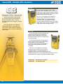
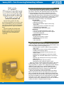
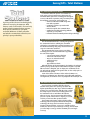
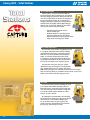
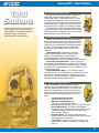
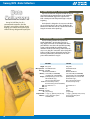
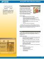
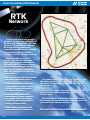
Survey/GPS Catalog
800-500-8575 • www.topconca.com
Commitment to our Clients
We understand the value of the relationship we have with our clients. You are our
most important asset. We will work very hard to make sure that we provide the
courtesy, attention and satisfaction that you would expect from a professional
organization. You will receive ...
• Outstanding customer service
• The highest quality products
• Unmatched product selection
• Value based pricing
We want to take this opportunity to thank you for your support over the past
12 years.
...Thank You!
www.topconca.com • Phone: 800-500-8575 • Fax: 916-374-8329 • 3380 Industrial Blvd. Suite 105, West Sacramento, CA 95691
Topcon California has approximately
4,000 square feet dedicated to your
supply needs! We make every effort
to ensure that your order is handled
quickly and correctly!
We are very proud of how pleasantly
surprised our customers are when they
visit our facility. It’s very common to
hear, “This is just like a candy store!”
Be sure to visit www.topconca.com for:
•
•
•
•
•
Product Information
Special Sale Information
Used Instruments
Special Announcements
Technical Support
TOPCON CALIFORNIA
SACRAMENTO
Topcon California is a “factory owned” retail store. There are only two of these type stores in the
entire United States. The Sacramento facility officially opened in January 1994 starting with six
employees. At that time, Topcon California occupied a total space of 4,000 square feet. Today
we have 25 employees and occupy approximately 10,000 square feet of space.
Table of Contents
Survey/GPS Catalog
HiPer® Family............................................................... 4-5
HiPer®XT, HiPer®Pro, HiPer®Lite+, HiPer®+, HiPer®L1
Millimeter GPS™.......................................................... 6-7
Modular GPS+ Receivers............................................... 8.
GB-500, GB-1000.
.
GPS Antennas ................................................................ 9.
CR-3, PG-A1, PG-A2
GIS Mapping............................................................. 10-11
GMS-2, GMS-200, GMS-110
Post-Processing/Network Software........................... 12.
Topcon Tools, TopNet Cors, TopNet RTK.
Total Stations........................................................... 13-15.
GPT-8200A, GPT-8203, GTS-820, GPT-7000i, GPT-7000, . ...
GTS-720, GTS-230W, GPT-3000W, GPT-3000LW .
Data Collectors & Software................................... 16-17
FC-2000, FC-100, TopSURV, TopLink.
.
Theodolites & DL Electronic Levels........................... 18
DT-200, DT-200L
Auto Levels.................................................................... 19.
AT-G Series, AT-24A.
.
Accessories............................................................... 20-21
Batteries & Chargers
RTK Network.................................................................. 22
Rental Rates.................................................................. 23
Index..............................................................................24
Survey/GPS - Integrated GPS+ Receivers
HiPer
Integrated GPS+ Receiver
The HiPer® Series of integrated
GPS receivers/antennas offers GPS
technology options for every need
and budget.
Each of the members of the
HiPer®Series feature an integrated
design that includes a GPS receiver,
antenna, and power supply – all
in a compact, waterproof, durable
housing that is designed to take the
bumps and bruises of the field.
Topcon’s GPS+ offers GPS plus GLONASS (dual-constellation)
gives you 40 percent more satellites to use, fewer headaches
in the field, and the most advanced GPS signal processing
and interference reduction in the industry. At the core is our
Paradigm™ chip featuring 40 universal super channels that can
each track all signals of either single-frequency GPS, dualfrequency GPS, or dual-frequency GPS+. Also, with 40 channels
you can track up to 20 satellites at once!
HiPer®XT RTK Integrated GPS+ Receiver
At the heart of this new system is Topcon’s
HiPer XT (eXtended Technology) system design.
This new receiver design provides a user with two
forms of RTK communication all inside one compact,
lightweight housing.
The HiPer®XT incorporates both a transmit-andreceive 2-watt UHF radio and a cellular modem giving
you two systems in one. Use two HiPer®XT receivers
as a base and rover system for areas outside reliable
digital cellular coverage. When operating in an area of reliable cellular
coverage or within an RTK network system, use both HiPer®XT receivers
as rover units to double your productivity and efficiency!
Many of these features are World’s Firsts:
• Completely cable free base & rover or rover & rover
RTK GPS System.
• World’s First 2-watt UHF Transmit & Receive system with
built-in cellular modem.
• Dual-constellation (GPS+GLONASS) satellite positioning technology.
• 40 channel all-in-view signal tracking ability.
• Industry leading 20Hz fast update rate.
• Upgradeable receiver options through simple computer codes.
HiPer®Pro Long-Range Integrated Receiver System
The innovative integrated design incorporates
a transmitting UHF radio in the base receiver,
eliminating the need for external radios and
batteries. And there’s no need to worry about UHF
radio interference because Topcon’s Free Channel
Scan technology detects disruptive radio signals and
compensates by automatically changing channels so
you can keep working all day with confidence in your
HiPer®Pro system.
The HiPer®Pro utilizes advanced Bluetooth® wireless technology
to give you a system free of the messy cables found at many base
stations. No more hassles of dealing with tangled, fragile cables
from external batteries, antennas, and RTK radios because the
wireless HiPer®Pro provides a complete, integrated RTK GPS system
with the added benefit of extended working range.
Standard Features:
• Completely cable-free design
• Long-range UHF radio – up to 4 miles of coverage!
• Compact, lightweight design
• Fully integrated receiver/antenna
• Dual-frequency, dual-constellation RTK GPS+ tracking
Survey/GPS - Integrated GPS+ Receivers
HiPer
Integrated GPS+ Receiver
The HiPer® Series also incorporates
our innovations in signal processing,
Advanced Multipath Reduction, and
Co-OpTM Tracking, making Topcon GPS+
the best in the field in under-canopy
and low signal strength reception.
HiPer® Lite+ Integrated GPS+ Receiver System
This compact system incorperates Topcon’s advanced
40-channel dual-frequency GPS technology, the
ParadigmTM chip, and offers all the Topcon innovations
in tracking technology such as Co-OpTMTracking and
Advanced Multipath Reduction. The HiPer®Lite+ also
incorporates our Euro-80 GPS board and is designed for
dual-frequency GPS tracking.
HiPer® Lite + Features:
• Super-fast and easy base station setup – tripod, tribrach, and
HiPer®Lite+ – you’re done!
• Cable-free rover works with Bluetooth® wireless technology
equipped field controllers
• Integrated spread spectrum radio works with HiPer®Lite + and standard HiPer®Lite rovers up to 1.5 miles away
• No FCC licensing requirements
• 40-channel dual-frequency GPS plus GLONASS availability
• Exclusive AMR and Co-op Tracking™ technology
HiPer®+ Integrated GPS+ Receiver System
HiPer®+ continues to offer the advantages of a small,
lightweight design and the power of dual-constellation
satellite tracking. In addition, the HiPer®+ boasts
wireless communication and an advanced center-mount
UHF antenna design that boosts RTK performance and
distance without any degradation of GPS signals!
Now avalible with GSM modem option! The new
HiPer®+ now can be ordered with either internal radio
or with internal GSM cell phone communications.
With GSM, just add a SIM card from a domestic service provider and
TopSURVTM GPS+ controller software to obtain rover connectivity with
cell-based reference station networks and long-range RTK without
radios.
• A data plan from a cellular service provider is required to use
GMS communications.
• Service providers that currently offer GMS/Data capabilities and SIM cards are: AT&T, T-Mobile, and Cingular Wireless.
Nextel offers GMS service but no SIM cards necessary for
HiPer®+.
• Contact a service provider for coverage maps and more
information.
®
HiPer L1 Single-Frequency Receiver Unlike other static GPS systems, the Topcon
HiPer®L1 is easily upgradeable to full-time dualfrequency L1+L2 with a simple computer code that
you can load yourself. Should you decide to go to
full dual-frequency RTK, you can easily upgrade the
HiPer®L1 with an internal PDL radio.
• Completely upgradeable system without having to swap
out hardware.
• Full dual-frequency measurements standard on “Cinderella”
days.
• Customizable system design with memory options up to 96Mb.
• 40 channel GPS receiver technology (Paradigm™ technology).
• Advanced Co-Op tracking for unsurpassed under-canopy
performance.
Survey/GPS - Millimeter GPS™
Millimeter GPSTM
World’s first millimeter-accurate
GPS system – up to 300 percent
more accurate than standard GPS!
Imagine taking your GPS rover and
transforming it into a super-precise
measuring device that rivals a robotic
total station. Or enabling your highly
productive 3D-GPS+ stake less grading
systems to speed through your highest
precision work. At a fraction of the
cost of a robotic total station system,
and without the single-user limitation.
Simply set up your Topcon RTK GPS+ system as usual, add a wireless
PZS - 1 sensor to your mobile rover, and set up the PZL - 1 transmitter
to get instant millimeter accurate elevations anywhere in the
LazerZone™.
PZL -1 Transmitter
Positioning Zone Laser transmitter sets up and
operates much like a standard rotating laser but
transmits a unique LazerZoneTM signal to provide
a working range of 2,000ft plus an incredible
measuring area of 33ft in height! Link up to four
laser transmitters for use on large sites to cover a
distance of nearly 8000ft with elevation changes
of more than 130ft. Multiple rovers can use the
same transmitter, even at different elevations for
continuous production.
Zone Width
Zone Radius
LazerZone Accuracy
Self-Leveling Range
Rotation Speed
Laser Class
Channels
Plumb Beam
Bluetooth® Wireless I/O Port
Power Supply
Operating Time
Waterproof
Operating Temperature
±10° (0-30m), ±5m
(30-300m)
300m (985ft) Vertical: 1 arc second
resolution
±5°
600rpm
Class 1 4 Yes Yes RS-232C Rechargeable Ni-MH (w/runcharge) 4 “D” Cell Batteries Approx. 20 hours (alkaline) Approx. 15 hours (rechargeable) IPX6 -20° to +50°C
PZS -1 Rover Sensor
Instantly computes precise vertical information
from the PZL-1 laser transmitter. Automatically
determines elevation based on your job site
control, eliminating the need for a movable mast
or grade rod. Mount the PZS-1 to your range
pole, where it receives the PLZ-1 laser signal and
wirelessly transmits data to your existing HiPer
rover.
Beam Detection ±10° by ±10° window
Channels 4
I/O Port RS-232C
Mounting 5/8 x 11 Thread
Waterproof IPX6
Operating Temp -20° to +50°C
Power Supply BT-59Q Camcorder Battery
Operating Time Approx. 8 hours
Weight Approx. 1kg
Survey/GPS - Millimeter GPS™
Millimeter GPSTM
99-051103-01 Consisting of:
99-051101-01 30-034121-01 30-034131-01 Millimeter GPSTM LazerZoneTMSystem Complete
LazerZone Transmitter & Receiver w/case
LazerZone Tripod w/bag
LazerZone Accessory kit w/bag
(1.83-2.0M Lazer-Zone composite rover rod, LazerZone bipod, & accessory bag)
99-051101-01 LazerZoneTM Transmitter & Receiver w/case
57099
Consisting of:
57101 Consisting of: PZL-1 Laser w/ TopSURV Millimeter GPS module
56999 - AC/DC converter AD-9B (120V) for PZL-1
57103 - Battery Pack BT-63Q for PZL-1
57104 - Battery Holder DB-63C for PZL-1
PZS-1 Sensor
57105 - PZS Plug
57106 - Sensor cable JC-8
60241 - Battery Charger BC-30 for PZS-1
60259 - Battery Pack BT-62Q for PZS-1
Controllers and Software
Part No
60322 60286 60288 60287 60289 60278 60280 60279 60281 60328 60329 60330
60331 60332 60272 60273 60336 60352 Description
TopSURV Millimeter GPS+ Software Module
FC-100, 64MB w/ TopSURV Pro GPS+
FC-100, 64MB w/ TopSURV Complete
Wireless FC-100, 64MB w/ TopSURV Pro GPS+
Wireless FC-100, 64MB w/ TopSURV Complete
FC-100, 128MB w/ TopSURV Pro GPS+
FC-100 128MB w/ TopSURV Complete
Wireless FC-100, 128MB w/ TopSURV Pro GPS+
Wireless FC-100, 128MB w/ TopSURV Complete
FC-2000 128MB w/ TopSURV Millimeter GPS+
BT Wireless FC-2000 w/128MB
w/ TopSURV Millimeter GPS+
FC-2000 128MB w/TopSURV Pro Millimeter GPS+
(w/Roading)
BT Wireless FC-2000 w/ 128MB
w/TopSURV Pro Millimeter GPS+
FC-2000 128MB w/ TopSURV Complete
TopSURV GPS+
TopSURV Pro GPS+ w/ Roading
TopSURV Millimeter GPS+
TopSURV Pro Millimeter GPS+(w/ Roading)
Accessories
56999 60241 60259 14-008051-01 30-034111-01 22-034102-01 22-034103-01 22-034104-01 22-034105-01 AC/DC Converter AD-9B (120V)
BC-30B (120V) Battery Charger
BT-62Q Battery, FC-100
PZS-1 - Leg E/Ody E/GB Series cable
2M LazerZone fixed height tripod
1.83 - 2.0M LazerZone composite rover rod
.5 Meter Composite rod extension
LazerZone accessory bag
Tripod Bag
Survey/GPS - Modular GPS+ Receivers
GB
GB - 500
The GB-500 provides advanced Topcon dualfrequency, dual-constellation, GPS+ receiver board
design inside a rugged, compact housing featuring a
simple MINTER display with LEDs providing satellite
tracking, battery, and recording status.
Modular GPS+ Receivers
At its core is our Paradigm® chip featuring 40
universal super channels that can each track
all signals of either L1 or L2 GPS frequencies.
It incorporates our new innovations in signal
processing, multipath mitigation and co-op tracking,
making Topcon GPS+ the best in the field for undercanopy and low signal strength reception.
The GB-500 and GB-1000 provide
an advanced Topcon dual-frequency,
dual-constellation, GPS+ receiver
board design inside a rugged, compact
housing.
Also, through the use of Options
Authorization Files, a customer can
select from a wide variety of options
to activate in the receiver to meet their
exact needs.
GB - 1000
The GB-1000 offers a built in LCD display and
operation panel. This display and interface is
ideal for checking satellite and receiver status,
initializing RTK base operation, or managing static
surveying operations.
The GB-1000 also provides a Compact-Flash
memory card slot and advanced communication
support. With USB, serial, and Ethernet
connections, nearly all communication links are
supported including LAN, WAN, and Internet
connectivity.
At its core is our Paradigm® chip featuring
40 universal super channels that can each track
all signals of either L1 or L2 GPS frequencies. It
incorporates our new innovations in signal processing,
multipath mitigation and co-op tracking, making Topcon GPS+ the best
in the field for under-canopy and low signal strength reception.
01-854502-01X
GB-500 Receiver, L1 w/cables
01-854402-01X
Assy, GB-1000 w/cables
Survey/GPS - Antennas
GPS
Antennas
The PG-A series of high-precision
GPS antennas is an exciting addition
to the complete line of Topcon
GPS products. These GPS microcentered antennas are available as
either a standard dual-frequency,
dual-constellation antenna (PG-A1)
or with the addition of integrated
UHF (PG-A2).
CR - 3 Zero-Centered Choke Ring GPS Antenna
The CR-3 is a zero-centered L1/L2 reference base station
antenna mounted on our single-depth choke ring. It
features a fully weatherproof design with an optional
cone environmental cover. The CR-3 choke ring
antenna brings proven technology and reliability to
high-end reference station systems.
It weighs about 3.7 kg with a diameter of
32.6cm and height of 10.1cm (without cone cover).
The included LNA accepts voltages from 2.7 to 12
volts and has 32 ± 2dB of gain. Output impedance
of the antenna is 50 Ohms. Frequency ranges are from 1565 to 1620
MHz and 1217 to 1260 MHz and the antenna has N-type connectors.
Features
Frequency
Weight
Dimensions
DC Voltage
LNA Gain
Output Imp.
Connector
Operating Temp
L1/L2; GPS/GLONASS; Reference base station antenna with choke ring; Ground Plane;
Zero Centered
Range 1: 1217-1260 MHz
Range 2: 1565-1620 MHz
3700 or 4100 with conic cap grams
326 x 101 w/o cap mm
Range: 02/07/2012 Volts
mA@current supply: 45@3 mA@typ.
32 ± 2 db
50 Ohm
N-type
Range: -40 to +55 degrees Celsius
Topcon continues its lead in GPS technology with the compact
and ultra-rugged PGA antennas. These high precision GPS microcentered antennas are available as either a standard dualfrequency, dual-constellation antenna (PG-A1) or with the addition
of integrated UHF (PG-A2).
PG - A1 Dual-Frequency/Dual-Constellation Antenna
The PG-A1 is a precision dual-frequency,
dual-constellation antenna featuring precision
micro-center technology and an integrated
ground plane to help eliminate errors caused
by multipath. The PG-A1 was designed to accompany the Topcon
modular receivers such as the Legacy-E, Legacy-H and Odyssey-RS.
PG - A2 Integrated UHF Antenna
The PG-A2 is the first antenna to provide both dualfrequency, dual-constellation satellite tracking and
integrated UHF antenna for maximum communication
range, all in one compact, durable design.
The PG-A2 is a precision dual-frequency, dualconstellation antenna with integrated UHF and
featuring precision micro center technology and an
integrated ground plane to help eliminate errors
caused by multipath. The PG-A2 was designed
to compliment the Odyssey-E integrated receiver,
UHG radio and Windows CE controller.
Survey/GPS - GIS Mapping
GMS
GIS Mapping
System
Incorporating advanced technology
not found in other hand-held GPS
units, the GMS-2 truly represents the
next generation of a compact satellite
positioning receiver.
Topcon engineers have incorporated our industry leading dualconstellation satellite tracking into a small hand-held GPS receiver,
the new GMS-2.
GMS - 2 GIS Mapping GPS Receiver
This innovative new system also provides an
integrated electronic compass and digital camera
powered by Topcon’s revolutionary imaging
technology. This powerful combination of dualconstellation satellite performance and digital
imaging technology has set a new standard for GIS
field mapping.
• Dual-Constellation Satellite Tracking
• Integrated Digital Camera & Electronic Compass
• Dual-use Performance as GIS Receiver or
Field Controller
• Internal Bluetooth® Wireless Technology
Connectivity
• Ultra Sharp Color TFT Touch Screen
Powered by Topcon’s TPSCORE® GPS chip technology, the
GMS-2 provides 50 channel tracking capability, for both GPS and
Glonass satellite systems. The TPSCORE® chip technology also provides
dual-purpose signal tracking for either meter-level GIS mapping
applications, or single-frequency carrier tracking for high-accuracy static
positioning. With an optional external L1 antenna, the GMS-2 can
perform post processed surveying applications for accuracies better
than 1cm.
In addition to being a stand-alone mapping grade receiver, the
GMS-2 can also utilize external correction services for real-time DGPS.
The GMS-2 provides access to the WAAS correction service as a
standard feature. Using its internal Bluetooth® connection, the GMS-2
can be configured to connect to a regional
GPS CORS network through a Bluetooth
enabled cell phone. When utilizing the
optional Topcon BR-1 Coast Guard
Beacon Receiver, the GMS-2 can correct
its raw GPS location for real time location,
mapping, and navigation applications.
A significant advantage of the GMS-2 is its ability to perform
multiple roles. With its Windows CE® operating system, a GMS-2 can
also be configured to be a field controller running the full suite of
Topcon’s TopSURV software to work with total stations and RTK GPS
systems. With the addition of the survey & GPS modules for TopSURV,
our GMS-2 can be used as either a stand-alone GIS receiver, or part
of an integrated system, providing flexibility not found in competing
systems.
10
Survey/GPS - GIS Mapping
GMS
GIS Mapping
System
The Topcon GMS series was designed
to provide a compact, rugged GIS
Mapping system that incorporates
all of the primary position correction
services – Beacon, WAAS, EGNOS, and
OmniSTAR®-VBS.
Utilizing Topcon’s integrated system design and Bluetooth®
wireless technology, the GMS-110 and the GMS-200 bring the
versatility of a backpack GIS solution without the mess of external
cables and components. The GMS receiver systems also provide
your choice of field data controller.
Users can also choose between ESRI’s ArcPad field solution
for the advanced GIS maintenance professional, and Topcon’s
TopSURV-GIS for the surveyor-friendly GIS data-acquisition system.
Both software systems are available on Topcon’s rugged FC-100
Windows® CE color touchscreen field computer.
GMS - 200 Multi-Purpose GIS/Mapping System
The GMS-200 system comes configured as a complete
backpack system. At the heart is the new Map-HP receiver.
Within its HiPer-sized, lightweight housing, Topcon has
packed a wealth of unbelievable technology. Consisting
of a Map-HP receiver with cables and charger, GPS L1/L2
data option, 10Hz RTK, WAAS option, internal PacCrest
compatible radio, 4Mb internal data storage, Omnistar
VBS/HP capable, MG-A2 antenna with adapter, and GIS
backpack w/pole. Just add an FC-100 or FC-2000 field
computer for a complete system!
• Built around our survey grade T112 GPS
board, the same powerful and reliable one
used in all of our popular HiPer series!
• Internal batteries eliminate cable hassles and
provide 15 hours of continuous use.
• MG-A2 antenna delivers dual-frequency and L-band reception in a waterproof, small enclosure!
• Integrated Bluetooth® communications!
• OmniSTAR®-VBS service delivers sub-accuracy while Omnistar HP is under 10cm accuracy!
• It’s RTK-ready with internal, PacCrest compatible, UHF radio for centimeter level survey-grade accuracy!
GMS - 110 Multi-Purpose GIS/Mapping System
The new Topcon GMS-110 system was designed to
provide a compact, rugged GIS Mapping system that
incorporates all of the primary position correction services
– Beacon, WAAS, EGNOS, and OmniSTAR®-VBS. Utilizing
Topcon’s integrated system design and Bluetooth®
wireless technology, the GMS-110 brings the versatility of
a backpack GIS solution without the mess of a bunch of
external cables and components.
• Sub-meter accuracy with real-time differential
correction from OmniSTAR®-VBS and
Navigation Beacons.
• OmniSTAR® satellite differential correction
provides wide area coverage.
• Coastal navigation beacons provide free
differential correction over most of North
America and Europe.
• WAAS and EGNOS ready.
11
Survey/GPS - Post-Processing/Networking Software
PostProcessing/
Networking
Software
Topcon Tools provides the data
processing capabilities you need for your
GPS system. With it, you get a powerful,
easy-to-use solution for post-processing
and adjustments for Topcon and RINEX
data!
Topcon’s TopNet also breaks new
ground as the world’s first reference
station software suite to offer dualconstellation GPS+GLONASS data
capability.
Topcon Tools Post-Processing and Adjustment Software
Topcon’s new Topcon Tools software provides a powerful postprocessing solution with an intuitive operator interface that’s easy to
learn and use. Impressive data automation routines take much of the
hassle out of GPS processing and get you the right answer fast!
Graphical Windows® based screens provide a map view of your
project along with sortable tables of observation and vector information.
With user-defined reports and customizable job configurations, Topcon
Tools can process and report data for specific projects and users.
Powerful data checking and editing is at your fingertips!
Post Processing
• Topcon GPS+ data processing
• RINEX data processing
• Direct import of data from Topcon receivers using
Topcon Link™
• Graphical map interface and tabular view of data
• Customizable job configurations
• Customizable point and baseline reports
Adjustments
• Least squares network adjustment of GPS+ data
• Extensive projection support and Geoid 99 support
• Customizable adjustment
• Export to industry standard formats
Import Data From:
• All Topcon GPS and GPS+ receivers
• RINEX data from any GPS receiver
• NGS data sheets
• ASCII control files
TopNET Reference Station Software
A key component of the modern GPS industry is the fixed reference
station, and Topcon’s innovative TopNet reference station software suite
is the perfect solution to meet this growing need.
• Communication to reference stations via Internet, modem, USB or serial
• Configuration of reference stations and site perimeters including remote firmware upload.
• Configuration of DGPS/RTK local broadcast from each reference station
• Configuration of data logging for each reference station
• Automatic and manual file download from each reference station
• Automatic and manual push to FTP site(s) of raw and/or RINEX data files
• Monitoring of satellite and site parameters
• Automated message sending on alarm via email
Topcon can provide a suite of TopNet products offering a wide range
of functionality scalable – from a single site to networks covering a
large geographical area. TopNet can be configured to provide complete
control over a single CORS site or a network of CORS sites with
additional options, giving you GPS+ RTK correction data generated
using information from all reference stations to model and reduce
errors, thereby improving precision and productivity.
Just place your static GPS+ antenna on the roof of your building,
link the cable from the antenna to the Odyssey-RS receiver in your
office, and TopNet will collect periodic positioning data automatically.
Combine this data with the information collected by your survey rovers
in the field, and TopNet processes the combined data in no time. With
TopNet you can log, archive, and post raw data files, convert RINEX,
and upload native raw files and RINEX files to an FTP site, all under the
security and control of a designated system manager.
12
Survey/GPS - Total Stations
Total
Stations
Topcon provides the most technologically
advanced surveying instruments. With
features such as the world’s first and only
optical robotic communication systems,
dual-optical reflectorless operation,
on-board Windows®CE data collection
and wireless remote data collection, our
priority is your productivity.
GPT–8200A Reflectorless Robotic
For the times when the job site or circumstances
make using a prism inconvenient or dangerous, the
GPT-8200 utilizes pulse-laser technology for the highest
accuracy reflectorless operation. Using a standard prism,
the GPT-8200 can measure a full 23,000 feet.
• Advanced reflectorless EDM design with
two mode operation.
• Completely cable-free operation with
wireless RC-2II.
• Radio-free optical data communication
• Sophisticated tracking technology without expensive, special prisms.
• Innovative Movement Anticipation tracking technology.
GPT - 8203M Reflectorless Robotic
The GPT-8203M instrument is covering new ground in
the construction business. Utilizing the remarkable
reflectorless range EDM of the standard GPT-8200 series,
the M instrument brings long-range measurement into
range for construction customers.
The GPT-8203M also boasts proven servo-driven
technology that can turn the instrument very quickly to
the next stakeout point.
• 7 speed servo-motor technology
• 1200 meter reflectorless range
• Easy to use onboard software
• Cable-free design
• Guide lights
• Upgradeable to robotic
Onboard software of the GPT-8203M is also intuitive. The onboard
software package makes upload and download of points easy. With
little more than a blueprint, you can input your coordinates for the
job and get them marked on the ground. You can also easily replace a
knocked-out hub quickly.
Some of the advanced features of the onboard software are;
batterboard calculation, tape dimension, and roading with templates
and alignments, all of which can be very helpful on the modern job site.
GTS - 820 Auto-Targeting/Auto-Tracking
Speed, precision, versatility, reliability. The new
GTS-820 series puts it all in a package to deliver the
highest productivity day after day, in all field conditions.
Compare it to any other robot. Sight the prism, activate
the unique Topcon “wide beam” tracking system and
the instrument locks on and follows the reflector
wherever it goes. The fast servo-motors will track the
prism at a speed of more than 12 degrees per second,
a full 20 percent faster than previous models.
The GTS-820 now features advanced CCD tracking
technology which incorporates Movement Anticipation
technology. This keeps the beam stuck to the prism
for unprecedented tracking accuracy. It is available in three
models; the GTS-821A (1-second angle accuracy), the GTS-823A
(3-second angle accuracy), and the GTS-825A (5-second angle
accuracy).
13
Survey/GPS - Total Stations
Total
Stations
CAPTURE
R E A L I T Y
GPT -7000i Imaging
Capture reality – don’t just measure it! With its
integrated digital camera technology, the new Topcon
GPT-7000i imaging total station makes your field data
come alive. Captured job site photos are incorporated
into your measurement data, or use the onboard
imaging technology to superimpose design points or
stakeout points. By adding optional digital imaging
software you can combine multiple job site photos
and create 3D models and point clouds!
• Dual-view integrated CCD camera:
wide and finder view
• Windows CE.NET 4.2 operating system
• Extra-large QVGA LCD TFT color display
• Pinpoint reflectorless measuring up to 250m
• Single prism measuring up to 3000m
GPT -7000 Reflectorless
The GPT-7000 series provides everything you need
in a complete reflectorless field solution including
advanced lithium-ion battery, removable Compact
Flash data card, and powerful on-board software.
Finally, an on-board solution that makes handsfree surveying a reality, with advanced reflectorless
capability that outperforms all other instruments in
its class! The GPT-7000 series, only from Topcon!
The GPT-7000 series gives you up to 1200m
reflectorless range, the longest in its class! Measure
up to 3000m with a prism. The unique dual optical
EDM design takes pulse laser reflectorless measurement to a higher
level. Even at long distances, it maintains focused beam accuracy and
allows you to measure only the target you select.
GTS -720
The GTS-720 series provides everything you need
in a complete field solution including advanced
lithium-ion battery, removable Compact Flash data
card, and powerful on-board software. Finally there
is an advanced field solution without the added
expense of a data collector.
By adopting the latest Windows® CE technology,
Topcon brings the advantages of the GUI (Graphical
User Interface) to a total station. Whether you
are an experienced user or just a beginner, the
graphical interface and intuitive design will allow
you to get up and running in no time.
14
Survey/GPS - Total Stations
Total
Stations
Topcon is known for its innovation and
cutting edge optical equipment. We
offer a full line of optical instruments
designed using our exclusive
optomechatronic technologies.
GTS - 230W Wireless Total Station
Like Topcon’s GTS-220 Series, the GTS-230W Series is
loaded with standard features including a long-life
10-hour NiMH battery, a “Point Guide Feature” to allow
fast alignment in staking tasks, and a laser plummet to
help make setup fast and easy. Even wireless operation is
standard with the GTS-230W Series, so you don’t have to
worry about messy or tangled cables slowing you down!
On board data collection, handy application programs,
and increased distance range and EDM accuracy complete
this package that’s been designed to speed up your work
while ensuring accuracy and ease of use.
GPT - 3000W Wireless, Dual-Optical
With the GPT-3000W series reflectorless total stations,
Topcon gives you the convenience of wireless technology
on the total stations with the longest reflectorless range
in their class. The GPT-3000W series provides the highest
measuring precision available due to its dual-optical
design, so you get incredible results every time, in all
situations.
Dual-Optical Design — Reflectorless measuring
requires a finely focused beam for pinpoint accuracy.
Prisms need a wider pattern to prevent off-center
measuring degradation. Topcon’s dual-optical system
gives you both for the maximum measuring accuracy all the time.
Precise Pulse-Laser Reflectorless — Topcon’s pulse-laser
“time-of-flight” system eliminates measuring errors caused by the
overlapping signals used in phase measuring systems. Accurately
measuring corners or through objects such as a chainlink fence is
always fast and reliable.
Longest Reflectorless Range — Up to 250m, the longest
reflectorless range in its class! Measures up to 3000m with a prism.
The dual optical design allows you the extended range using a
Class 1 laser — safe for all conditions — making it ideal for use in
high-traffic and other heavily populated areas.
GPT - 3000LW Long-Range Wireless
With its revolutionary 1200m reflectorless range the
3000LW sets a new standard for EDM range, delivering the
power for difficult shots that others just can’t match! The
new Topcon 3000LW series measures nearly four times
farther than any other competing total station, once again
demonstrating the technology advantages that Topcon
offers.
• 1200 Meter Reflectorless Range Measure 300m to ANY surface.
• Bluetooth® Communications - Just
add a FC-100 or FC-2000 with wireless Bluetooth capability and forget your cable problems forever!
• Precise Measurements - The ability of the 3000LW to
measure long-range is significant, but real advantage of this technology is what this increased measurement power
means at shorter distances.
• Dual-Laser Optics - one narrow beam for non-prism
functions, and a broader beam when using a prism for more
stable long-range measurement.
• “On-the-Spot” - highly focused infrared beam for a very stable, sharp spot that is less resistant to “spreading” over
distance.
15
Survey/GPS -Data Collectors
Data
Collectors
It may be half the size of a
conventional controller, but the
FC-100 is every bit as serious about
helping you control and collect your
critical survey, design and layout jobs.
FC-2000 Color Windows® CE Field Controller
Topcon’s FC-2000 was designed and built by Topcon,
not some third-party manufacturer. The FC-2000 was
built to the withstand rugged use required in the
field. A shockproof and waterproof design is only the
beginning.
The keyboard is designed to be easy to use whether
you are wearing gloves in the cold, or weathering the
summer heat. The unit even has a hook on the back to
hang the FC-2000 on the tripod leg!
FC-100 Windows® CE Field Controller
The FC-100 field controller incorporates the
graphical Windows® CE operating system on a
crisp, bright, color touch screen display that makes
your field data come alive. This powerful operating
system, combined with the versatility of dual
removable media for data storage and transfer; the
easy-access, long-life “camcorder” style rechargeable
battery; and the compact design that small on size,
but not in performance, makes the FC‑100 is the
perfect field controller for any job.
FC-2000
Weight
Microprocessor
Processor
OS
Memory
Display
Serial
USB
IrDA
Ethernet
BlueTooth
SD
Compact Flash
Batteries
16
800 grams
Intel PXA255 Xscale
400 MHz
Windows CE.NET 4.2
2 Eboot MB, 32 SDRAM MB,
128 (built in CF card) ROM MB
QVGA (landscape) 3.5 inch color
TFT Transflective type,
240 x 320 pixel dimensions
RS-232C Serial (D-sub 9)
RS-232C Serial (6 pin for total-station)
Type B mini Ver 1.1
no
no
Capable
yes (memory)
1 x Type I/_ (Memory and I/O card)
Li-ion rechargeable system
2200mAH/7.4V
FC-100
600 grams
Intel PXA255 Xscale
400 MHz
Windows CE.NET 4.2
0.512 Eboot MB, 64 SDRAM MB,
64/128 (built in CF card) ROM MB
QVGA (Portrait) 3.5 inch color TFT
Transreflective type,
240 x 320 pixel dimensions
RS-232C Serial (D-sub 9)
Type B mini Ver 1.1
no
no
Capable
yes (memory)
1 x Type I/_ (Memory and I/O card)
Li-ion rechargeable system
2200mAH/7.4V
Survey/GPS -Data Collection Software
GPS
Software
Windows® CE software for field
data collection, stakeout, and
control work.
TopSURV - Field Controller Software
This new Windows® CE software
installs easily in just minutes onto the
new Topcon FC-2000 field computer
and Topcon FC-100, or other popular
Windows® CE devices such as the At-Work
Ranger, Compaq IPaq or the Panasonic
Toughbook. Providing the user with an
intuitive graphical user interface, TopSURV
has set a new standard for field data
collection, stakeout, and control work.
Features Include:
• Internal NTRIP client added in TopSURV.
• Support Long Non-Prism mode added for GPT-3000L,
GPT-7000L, and GPT-8200A Total Stations.
• Display Cut/Fill values before storing a stakeout point.
• Ability to modify the HI for Resection when accessed from the Survey menu.
• Added Coarse mode data collection to the scanning function.
• Improved communications with RC2W.
The menus and screens have been designed with the operator in
mind. No hassles of hunting around for an option hidden deep inside
some sub-menu. All of the important field operations and features are
available at the press of a button or tap on the screen.
TopLinkTM
Topcon LINK is an import/export utility that aids in the transportation
of data to and from various Topcon instruments to a desktop or
laptop computer where post processing applications may be used to
manipulate the it.
TopLink can be used to:
• Import files from Topcon conventional total stations, robotic total stations, CE-based total stations, TPS controllers, and TPS GPS+ receivers to a computer.
• View and edit coordinate and raw data files and TopSURV files.
• Export an Option Authorization File (OAF) from computer to
TPS GPS+ receivers, coordinate data files to a total station,
any files to a TPS Controller.
• Edit localization parameters.
• View Linework information and images in the TopSURV job.
Import Data From:
• All Topcon GPS and GPS+ receivers
• Topcon total station import
• FC-2000 Data Collector
• RINEX data from any GPS receiver
• NGS Datasheets
• ASCII control files
17
Survey/GPS - Teodolites & DL Electronic Levels
Theodolites &
DL Electronic
Levels
Topcon’s DT-200 Series comes in two
variations: The standard DT-200 and
the deluxe DT-200L with an additional
laser for precision aiming.
The innovative DT-200 Series is the world’s first waterproof
and dustproof digital theodolites. They can stand up to any “wetweather” or dust condition in the field (DT-205/207/209 based on
IP-66). The benefit is that you will experience no downtime on the
job due to inclement weather.
DT - 200 High-Performance Digital Theodolite
The DT-200 series integrates the same high-quality
advanced absolute circle reading technology found in
Topcon’s high-performance total station products for more
accurate field calculations; and they continue to deliver the
highest quality optics and electronics you expect to find in
Topcon theodolites.
Available in three affordable models delivering 5”, 7”, or
9” angle accuracy, there is a DT-200 theodolite perfect for
any job. All models are compact and lightweight for easy
portability; their simple operation provides precise measurement in a
functional, hassle-free package.
DT - 200L High-Performance Digital Theodolite
The new DT-200L Series feature the same high-quality advanced
absolute circle reading technology found in Topcon’s high-performance
total station products, and they continue to deliver the highest quality
optics and electronics you expect to find in Topcon theodolites. All this,
plus the addition of a laser diode that’s perfect for easy, one-person
alignment jobs.
Topcon’s DL-101C/102C takes accuracy and ease of operation
to a higher level with its Advanced Image Process Technology.
The outstanding features make the DL-101C/102C ideal for high
precision applications including the performance of 1st and 2nd
order leveling and deformation monitoring.
DL-101C Digital Level
DL-102C Digital Level
With two levels of accuracy (0.4mm/1.0mm),
Topcon’s DL-101C and DL-102C Digital Levels
increase speed, accuracy and productivity in
the field. Both levels store data internally or to
a memory card through the standard PCMCIA
slot. The internal memory is 256K and up
to 8,000 points can be stored in memory. A
data collector can also be connected to the
DL Series RS232 port for differential leveling.
Processing software that includes a high
precision least squares adjustment routine is
also available. Enhanced features of the DL
series software include Inverted Rod Readings,
Compatibility with STAR* LEVEL Software and
User Defined Point Numbers.
18
Survey/GPS - Auto Levels
Auto Levels
Topcon offers a wide range of levels
for the land surveyor, civil engineer,
and contractor. These superiorly crafted
levels come in several categories
built for specific applications and
designed to suit any varying degrees of
functionality and budget constraints.
AT - G Series
Topcon offers a wide range of automatic levels
for the land surveyor, civil engineer and contractor.
All AT-G series levels feature a magneticallydampened compensator hung by four special
mylar ribbons having superior resistance to cold,
heat, and shock. The AT-G1 model features a 360°
glass horizontal circle using a 25x magnification microscope to read the
circle, while the AT-G2 thru AT-G7 have a standard 360° horizontal circle.
All models are waterproof with a nitrogen gas sealed telescope which
prevents clouding and moisture on the lens.
AT-G1
AT-G2/G2A
AT-G3
AT-G4
Telescope:
Length(mm/in.)
229/9
229/9
230/9
192/7.7
Image
Erect
Erect
Erect
Erect
Magnification
32x
32x
30x
26x
Objective Lens(mm/in.) 45/1.8
45.1.8
40/1.6
30/1.2
Relative Brightness
1.98
1.98
1.78
1.33
Field Of View
1° 20’
1° 20’
1° 30’
1° 30’
Resolving Power
2.5”
2.5”
3.0”
3.5”
Minimum Focus(m/ft.)
1.0/3.3
1.0/3.3
0.5/1.6
0.5/1.6
Stadia Constant
0
0
0
0
Stadia Ratio 100
100
100
100
Automating Leveling:
Setting Accuracy
Compensating
Range
AT-G6
AT-G7
193/7.7
Erect
24x 30/1.2
1.56
1° 30’
4.0”
0.5/1.6
0
100
204/8
Erect
22x
30/1.2
1.86
1° 30’
4.0”
0.9/2.9
0.1
100
± 0.3”
± 0.3”
± 0.3”
± 0.3”
± 0.3”
± 0.5”
± 15’
± 15’
± 15’
±15’
±15’
± 10’
Accuracy
1km Double Run Level: Without Optical ± 0.7
± 0.7
± 1.5
± 2.0
± 2.0
Micrometer (mm)
With Optical ± 0.4
± 0.4
± 1.0
—
—
—
Micrometer (mm)
Horizontal Circle:
Diameter (mm/in.)
90/3.5
90/3.5
117/4.6
117/4.6
117/4.6
1°(0.1g)
1°(0.1g)
1°(0.1g)
1°(0.1g)
Minimum Division
10’(0.1g)
± 2.5
–
102/4.0
1°(0.1g)
AT - 24A Automatic Level
The AT-24A is ideal for construction and surveying
contractors who demand the highest levels of
accuracy, reliability, and robust performance at the
lowest possible cost.
The AT-24A is available as in a kit called a “Grade
Pack,” which includes the AT-24A Level, a carrying
case, and a Topcon Tripod.
Telescope
Image:
Magnification:
Clear Objective aperture:
Minimum focus:
Stadia Constant:
Stadia Ratio:
Erect
24x
1.4 in (36mm)
2.6 ft (0.8m)
0
100
Degrees of Graduation:
1°
Sensitivity:
8’/2mm
Setting Accuracy:
Compensating Working Range: Accuracy
In 1 km Double Run Level:
±0.5”
±15’
Horizontal Circle
Circular Level
Automatic Leveling System
±2.0mm
19
Accessories – Batteries & Chargers
Accessories
Please request our “Field Supply Catalog”
for a complete listing of prisms, prism
accessories, rods and tripods as well as
our entire line of general field supplies.
Rover Rods
5125-00
Rover rod 5/8” x 11” fluorescent yellow
5125-20-YEL-GT Rover rod snap lock fluorescent yellow
5128-00
Rover rod carbon fiber
22-006003-01 Litepole (aluminum rod)
22-006004-01 Litepole (composite)
Rover Rod Accessories
8160-00
Prism pole bag
5001-20
Heads-up rod level
56273
Replacement shoe
56275
Topo shoe
56276
Large topo shoe
5194-00
Steel shoe w/replacement tip
5194-03
Steel shoe w/steel replacement tip
6000-002
Replacement tip for 5194-00
5195-00
Prism pole adjuster
5131-00
2’ Prism pole extension
91600
Steel tip for Composilite prism pole
91601
Topo boot for Composilite prism pole
91605
Point & tip for Composilite prism pole
Rover Rod and Fiberglass Adapters
2080-00
Female, 5” x 11” to Quick Release
2090-00
Female, Quick Release to 5/8” x 11” male
5180-00
Male, 5/8” X 11” to Male 5/8” x 11”
5181-00
Double female, 5/8” x 11”
2131-00
5/8” x 11” to 1/4” x 20”
GPS Tripods
5115-00-YEL
5119-00-YEL
5119-10-YEL
Precise GPS Tripod fixed height
Collapsible GPS Antenna Tripod
Heavy Duty GPS Antenna Tripod
GPS Cables
14-008005-03 14-008023-01
14-008027-01
14-008031-01
14-008016-03
14-008012-01
14-008012-03
Receiver to Serial DB9
Cigarette Lighter to SAE
Receiver to SAE
Receiver to USB
Receiver to SAE
Antenna cable (3m) to Legacy-E
Antenna cable (10m) to Legacy-E
GPS Antenna
30-050501-01
30-004101-01
30-030012-01
DG450BN
DXR45BN
HiPer Pro Antenna
Integrated UHF Rubber Duck Antenna for HiPer
HiPer Lite Antenna
Dual Ban Antenna 6¼”
HiPer+, HiPer Pro, HiPer XT Antenna
GPS Radio Antennas and Accessories
30-000048-03
C01263
CW4450C
B4503
A00911MOD
30-000024-01
30-000026-01
20
PDL Antenna, 2.4dBi 410-430
Mobile Antenna, 2.4dBi 450-470
Whip Antenna, 5 dB
Machine Rover Antenna 3dB 11”
Mag Mount 25’ RF cable
35W Radio to Legacy-E Cable
2W Rover to Legacy-E Cable
Accessories – Batteries & Chargers
BATTERY GUIDE
Instrument.............................. Battery
GTS-2B.............................................BT-5Q #51738
GTS-2R.............................................BT-17Q #51747
GTS-3B/C/D...................................BT-15Q #51749
CTS-1/2............................................BT-23Q #51725
GTS-4/ITS-1....................................BT-20Q #51748
GTS-200/210-GPT-1003.............BT-32Q #51727
GTS-220/GPT-2000/3000..........BT-52QA #51730
GTS-300/310GPT-1001/1002...BT24QW#51726
GTS-600/720/GPT-6000C..........BT-50Q #51739
GTS-510/710..................................BT-30Q #51727
GTS-800...........................................BT-56Q #60042
GMT-100..........................................BT-40Q #51719
AP-L1A..............................................KIT #50093K
DL-101/102....................................BT-31Q #52200
DM-A5..............................................BT-18Q #51728
DM-S2/S3.......................................BT-6Q #51735
DT-101/102....................................BT-35Q #53334
Total Station Batteries
51734 BT-3Q Battery Pack
50093K 12V Battery Kit – AP-L1A/
GTS-800(consists of 50093,
50091 & 50098)
50093 12V Battery – AP-L1A/GTS-800
50091 Soft Battery Case – AP-L1A
50098 Power Cable – AP-L1A
51719 BT-40Q On-Board Battery – GMT100
51724 BT-32Q On-Board Battery –
GTS-220/210/200/GPT-1003
51725 BT-23Q On-Board Battery – CTS-2/1
51726W BT-24QW On-Board Battery –
GTS-310/300/GPT-1001/1002
51727 BT-30Q On-Board Battery –
GTS-510/710
51730 BT-52QA On-Board NiMH Battery – GTS-220/GPT-2000
51731 BT-56Q On-Board Battery –
GTS-810/820/8000
51733 BT-2 On-Board Battery – GTS-2
51737 BT-3L Heavy Duty Battery –
all TS & EDM
51738 BT-5Q On-Board Battery – GTS-2B
51739 BT-50Q On-Board Battery – GTS-600
51746 BT-14Q On-Board Battery – ET-1/2
51747 BT-17Q On-Board Battery – GTS-2R
51748 BT-20Q On-Board Battery –
GTS-4/ITS-1
51749 BT-15Q On-Board Battery –
GTS-3/B/3C/D
DT -100 and DL-100 Batteries
53334
52200
BT-35Q Battery –DT-100 Series
BT-31Q Battery –DL-100 Series
GPS Magnetic Mounts
5114-01
Mag Mount- 3 magnets with quick release disconnect
5114-50
Mag Mount- single magnet with 5/8” X 11”
5114-51
Mag Mount- single magnet with quick release disconnect
5111-01
“Short” Quick Release Disconnect Adapters
GPS Vehicle Brackets
5114-20-YEL Truck Door Bracket to hold rover rod & antenna
5198-51
ATV Pole Bracket w/o Radio Pole
Power Cables
51750
51752
51753
51754
Battery Cable 1 for GTS-10D/DM-C2
Battery Cable 3, Lemo Style/GTS-2/DM
Battery Cable 4, 4-Pin Style GTS-/4/300/600/700/800ITS/ET
Battery Cable PC6 for BT-3L
Chargers & Converters
51722
51740
51741
51742
51743
51744
51755D
51756
51757
51758
51769D
52210
53345
51700
51701
51702
51703
51704
51705
51720
51766
51767
Auto Converter 5-12V to 8.4V
BC-4 Lemo Style 120V Battery Charger
BC-10B 4 Pin Charger 120V
BC-5 Quick Charger 4 Pin only 120V
BC-6 Heavy Duty Charger f/BT-3L
BC-10C 4 Pin Charger 230V
BC-20BR Chgr. for GTS-310/510/710/GPT-1001/1002 120V
BC-20CR Chgr. for GTS-310/510/710/GPT-1001/1002 230V
BC-27BR Chgr. for GTS-800/8000/600/220 120V
BC-27CR Chgr. for GTS-800/600/220 230V
BC-19BR Chgr. for GTS-210/200/2/2B/GMT-100/
GPT-1003/DL-100
BC-23B Standard Charger for DL-100 Series
BC-26 Chgr. for DT-100 Series Univ. Charging System
Universal Charger Base without cable
Cable, 3 Pin for GTS-220/600/800
Cable, 4 Pin for GTS-3/4/ITS1
Cable, 2 Pin for GTS-210/200
Cable, 2 Pin for GTS-310/510/710/GPT Series
Cable, 2 Pin LEMO Style
110 VAC Wall Adapter
Battery Cable with Clips
Voltage Reg. Module w/10’ Cable/Clips for GTS-800
12 Volt Charger
BPS1272
12 Volt Charger, 7.2Ah
Eyepieces and Filters
51311
Solar Reticle for GTS-210/200/GPT-1003
51321
Solar Reticle for GTS-2/2B/2S/ET-1/2
51341
Solar Reticle 6 for IT-S1/GTS-4/800/600/220/310/510/710/
GPT-1002/1002/GMT-100
51351
Solar Reticle for GTS-3/3B/3C/3D/2R
51332
Solar Filter for GTS-210
51331
Solar Filter for GTS-200
51322
Solar Filter for GTS-2/2B/2S/ET-1/2
51344
Solar Filter “Flip Up” for GTS310/510/710/800/
600/220GPT Series/GMT-100
51352
Solar Filter “Flip Up” 3, for GTS-3B/3C/3D/3C/2R
51363
Solar Filter “Flip Up” 5, for ET-1/2/GTS-2B
51318
Diagonal Eyepiece for GTS-210/200/CTS-1/2
51320
Diagonal Eyepiece for GTS-2/2B/2S
51330
Diagonal Eyepiece for ET-1/2
51340
Diagonal Eyepiece for GPT/310/510/800/600/220
53331
Diagonal Eyepiece for DT-100
55301
Eyepiece Prism with Darkener for DT100/100L
55303
Roof Plummet for DT-100
21
Dual-Constellation RTK Network
RTK
Network
Topcon California is very proud to
announce the exclusive availability of
the only dual-constellation - GPS and
Glonass - RTK network in California.
We designed our network with
reasonable baseline lengths allowing
us to yield the highest possible
accuracy as well as excellent coverage.
Working within our network
provides cost-effective operating
costs as well as great conveniences.
GPS and GLONASS bring you higher
productivity by giving you access to
more than 40 satellites. Below are
some other key factors to take into
consideration.
• Save 50% on your initial investment
not having to purchase a base.
• Eliminate having to set up a base
station get peace of mind not having to worry about security
concerns of the base.
• How about the unbelievable
convenience of simply stepping
out of your vehicle and in just
a few short minutes or seconds
getting a fixed position.
• Think about not having to deal
with crowded UHF frequencies!
22
The annual subscription fee is very reasonable as is
the wireless service. When all things are considered,
this method of surveying is extremely cost effective.
Check us out!
We have just added a new reference station in the
Vacaville area providing expanding coverage into
Solano County.
We are interested in growing our network to meet
the demand. If you are interested in hosting a base at
your location, be sure to contact us.
Be a part of the Topcon California network!
Equipment Rental: Please call for rates and availability
GPS+ “RTK” Receiver Systems
RTK Package
1– Base Receiver
1– Rover
1– Controller
1– Tribrach Adapter
1– Optical Plummet Tribrach
1– TP-10 Tripod
1– Rover Rod
1– Bi-Pod
1– Download PC software
RTK Accuracy
10mm + 1.5 ppm
horizontal
20mm + 2 ppm
vertical
1– HiPer w/integrated antenna, radio and batteries
1– Controller w/Rover rod & bracket
Network “RTK” Receivers
1– Network Rover
1– CDMA Modem
1– Controller
1– Download PC Software
Package “A” – Instrument Only
GTS-800/820 series (motorized)
GPT-8200 series (motorized & reflectorless)
GPT-7000/6000 series (reflectorless)
GPT-7000i (reflectorless & digital camera)
GTS-700/600 series
GPT-3000 series (reflectorless)
GTS-230 series
Package “B” –
Instrument Plus Prism, Prism Pole, and Tripod
RTK Rover only
Network “RTK”
Rover System Package
Total Station Packages
1st Rental
2 day
minimum
(includes training)
Data Collection & Accessories
Data Collection Systems
FC-100 w/TopSurv
(Topcon cable, PC cable, TopLink)
FC-2000 Collection System
(Topcon cable, PC cable, TopLink)
RANGER Collection System
(Topcon cable, PC cable, Survey Link)
Total Station Accessories
360 degree prism
Single prism assembly
Triple prism assembly
OP Tribrach
Prism pole
Bi-pod
Wood tripod
Aluminum tripod
Radius “Motorola” Radios & Accessories*
GP-1002 watt
GP-2004 watt
P1225 1 & 5 watt
*Radio package includes: 2 radios,2 nylon cases,
2 speaker mic, 2 extra batteries
GTS-800 series (motorized)
GPT-8200 series (motorized & reflectorless)
GPT-7000/6000 series (reflectorless)
GPT-7000i (reflectorless & digital camera)
GTS-720/600 series
GPT-3000 series (reflectorless)
GTS-230 series
Package “C” – Traverse Package
Instrument, 3 tripods, 2 prisms,
2 OPT Tribachs w/Adapters
GTS-800 series (motorized)
GPT-8200 series (motorized & reflectorless)
GPT-7000/6000 series (reflectorless)
GTS-720/600 series
GPT-3000 series (reflectorless)
GTS-230 series
Digital Level – Auto Level – Transit/Theodolite
Electronic Digital Level –
DL-102C digital level
* System includes: digital level, download cable to PC,
PC software, tripod, fiberglass rod
Auto Levels*
AT-G2
32X
AT-G3
30X
At-G6
24X
AT-G7/AT-22 22X
* All Auto level rentals include 1 tripod and 1 rod
Transits/Theodolites*
DT-209 10”
* All Transit/Theodolite rentals include 1 tripod and 1 rod
Accessories
Contractor’s 8’ rod
Fiberglass rod 25’
13.5’ Phily rod
Aluminum tripod
Wood tripod
Topcon California CAN NOT guarantee network coverage • MINIMUM 2 DAY RENTAL • 25% DISCOUNT ON SERVICE RENTALS
Rental options include the conversion from rental to purchase. Topcon California will apply 100% of the rental paid for the first 30 days.
For rental periods beyond 30 days 75% of the rental paid will apply toward the purchase price up to 80% of the stated rental value.
NO credit will be issued for LATE rental payments.
23
INDEX
A
H
T
Advanced Multipath Reduction 5
Antennas 9
AT-24A 19
AT-G Series 19
Auto-Targeting/Auto-Tracking 13
Automatic Level 19
Batteries 20
High-Performance
Digital Theodolite 18
HiPer 4
HiPer®+ 5
HiPer® L1 5
HiPer® Lite+ 5
HiPer®Pro 4
HiPer® Series 4, 5
HiPer XT 4
Theodolites 18
Topcon Tools 12
TopLinkTM 17
TopNET 12
TopSURV 17
TopSURV-GIS 11
Total 13
TPSCORE® 10
Transmitter 6
C
I
W
Chargers 20
Co-OpTM Tracking 5
CR-3 9
Imaging 14
Integrated GPS+ Receiver 4, 5
Integrated GPS+ Receivers 4
Wireless total station 15
D
L
Data Collectors 16
DL Electronic Levels 18
DT-200 18
DT-200L 18
Dual-Constellation 8
Dual-Frequency 8
LazerZone™
6
Long-Range Wireless 15
M
E
N
Equipment Rental 23
ESRI’s ArcPad 11
Networking Software 12
B
F
FC-100 16
FC-2000 16
Field Controller Software 17
G
GB-1000 8
GB-500 8
GIS Mapping 10
GMS-110 11
GMS-2 10
GMS-200 11
GPS 17
GPT–3000LW 15
GPT–3000W 15
GPT–7000 14
GPT–7000i 14
GPT–8200A 13
GPT–8203M 13
GTS - 230W 15
GTS-720 14
GTS–820 13
24
Millimeter GPS™ 6, 7
Modular GPS+ Receivers 8
P
PG-A1 9
PG-A2 9
Positioning Zone Laser 6
Post-Processing 12
PZL-1 6
PZS-1 6
R
Reference Station Software 12
Reflectorless Robotic 13
Rover 4
Rover Sensor 6
RTK 4
RTK Network 22
S
Software 17
Stations 13
Z
Zero-Centered Choke Ring
GPS Antenna 9
Topcon California is well known in the
industry for their servicing capabilities. We
receive repairs for all over the United States.
Our work comes in from surveyors, engineers,
construction companies and even other
surveying instrument dealers. We have been
focused on the service side of our business
from the very beginning. Regardless of the
required repairs, we have the equipment and
the personnel to tackle the job.
Experience, training and the proper tooling
is what makes the difference between an
average service center and an excellent
service center. We have more than 30 years
of combined experience repairing surveying
instruments of all kinds. All of our staff
members are regularly undergoing specialized
training courses. As you can see from the
pictures, our service center is equipped with all
of the necessary testing equipment. We have
full service capabilities from auto levels all the
way to GPS and robots.
Topcon California is a service orientated
company. We know that if we can provide
superior instrument repairs and superior
customer service, we will be your vendor of
choice. This is our overall goal. We are here to
win your business!
Machine Control, Laser
& GPS Catalog
3380 Industrial Blvd. Suite 105
West Sacramento, CA 95691
Phone 800-500-8575 Fax 916-374-8329
www.topconca.com