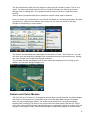
1
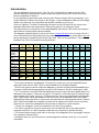
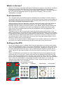
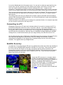
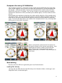
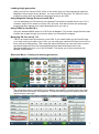
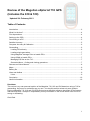
Review of the Magellan eXplorist 710 GPS (Includes the 610 & 510) Updated 25th February 2012 Table of Contents 1 Introduction ..................................................................................................................................... 2 What’s in the box? ........................................................................................................................... 4 First impressions ............................................................................................................................. 4 Setting up the GPS.......................................................................................................................... 4 Connecting to a PC ......................................................................................................................... 5 Satellite Accuracy ............................................................................................................................ 5 Compass Accuracy & Calibration .................................................................................................... 6 Geocaching ..................................................................................................................................... 6 Loading PQ’s directly ................................................................................................................... 6 Loading single geocaches............................................................................................................ 7 Using Magellan Vantage Point to handle PQ’s ............................................................................. 7 Using GSAK to handle PQ’s ........................................................................................................ 7 Managing PQ files on the 710 ...................................................................................................... 7 Geocache Menu – finding and viewing geocaches ...................................................................... 7 Camera and Voice Memos .............................................................................................................. 8 Maps ............................................................................................................................................... 9 Battery life ....................................................................................................................................... 9 Likes and dislikes ............................................................................................................................ 9 Likes: ........................................................................................................................................... 9 Conclusion .................................................................................................................................... 10 Useful Information ......................................................................................................................... 10 Disclaimer This review is my own personal opinion of the Magellan 710, 610 and 510 based on using a 710 for geocaching. Any errors or omissions are my own. You should use this review only as a guide to buying a Magellan 710, 610 and 510 GPS and not as a definitive reference document of the features and how they work. I accept no responsibility for any information in the review which turns out to be wrong or misleading. Chris Dale 1 Introduction The new Magellan eXplorist series, 710, 610, 510, 310 and GC are new to the UK. With specific features for geocaching, detailed maps and high sensitivity GPS receiver they are serious competition to Garmin. I’m an experienced geocacher and currently use a Garmin Oregon 550 for geocaching. I use Pocket Queries of caches and maps on the Oregon. I saw the Magellan eXplorist at the Mega Wales event and was very impressed and decided I wanted to try one out. I have an eXplorist 710 which is essentially the same as the 610 and 510 with some minor hardware differences and map options. Geocaching with all 3 is exactly the same. The table below is a comparison of the latest Magellan and Garmin GPS units, their features and functions including map options available. The Magellan eXplorist series is sold in the UK by Cotswold Outdoor who currently offer all 3 of the units with the full UK Ordnance Survey maps included in the price shown below, as well as the standard pre-loaded Europe Street/Topo map. This is a very good deal. They are also available from other UK stockists including Amazon. eXplorist 710 Geocaches 10,000 Waypoints 2000 Available 4Gb internal 1 Memory microSD Yes Card 2 Maps Yes Pre-loaded Yes 3 maps 4 Turn by Turn Yes 4 Navigation 5 Compass 3-axis 6 Camera Yes Video Yes Voice memo Yes 7 Wireless No Guide Price £5507 £440 eXplorist 610 10,000 2000 4Gb eXplorist 510 10,000 2000 2Gb Montana 650t 12,000 4000 3.0Gb Montana 650 12,000 4000 3.0Gb Montana 600 12,000 2000 3.0Gb Oregon 550t 5000 2000 850Mb Oregon 550 5000 2000 850Mb Oregon 450t 5000 2000 850Mb Oregon 450 5000 2000 850Mb Oregon 400t 2000 2000 850Mb Yes Yes Yes Yes Yes Yes Yes Yes Yes Yes Yes Yes Yes No Yes Yes Yes Yes Yes Yes Yes Yes Yes Yes Yes Yes Yes Yes Yes Yes Yes Yes Yes Yes Yes 3-axis Yes No No Yes £325 3-axis Yes No No Yes £280 3-axis No No No Yes £282 3-axis No No No Yes £240 2-axis No No No Yes Yes 4 3-axis Yes Yes Yes No £4507 £350 Yes 4 GPS Yes Yes Yes No 8 £350 Yes 4 3-axis Yes No No Yes £590 Yes 4 3-axis No No No Yes £480 Yes 4 3-axis No No No Yes £430 1 The memory quoted for the Magellan 710 and 610 is used up by the pre-installed Summit maps that come with the GPS. There is about 500Mb of free storage available. 2 All the units support various maps from Magellan or Garmin including USA/Canada/Europe (includes full UK) street/topographical and the UK GB Ordnance Survey (Landranger 1:50k). 3 The 710 and 610 come with USA/Canada/Europe Summit topo maps pre-loaded (which one depends on the region). These are very good. The Garmin‘t’ units come with the Garmin topo maps related to the region you buy it. These are similar to but not as detailed as the Magellan ones. These maps can be purchased for the other units. All the Magellan units come with a World Edition base map which is much more accurate than the ones supplied with the Garmin GPS. Open Street Maps are available free and can be loaded onto Garmin units very easily. These can be used on the Magellan but the process to add them is quite complex. 4 Turn by turn navigation for car (or pedestrian use) with voice guidance. 5 The 3-axis compass is electronic and means you can hold the unit at any angle and the compass works fine. A 2-axis compass needs the unit to held flat to operate correctly. 6 The camera allows images (and video in the case of the Magellan) to be ‘geotagged’ and you can navigate to photos/videos. 7 Wireless means you can send/receive caches/waypoints between units only. It is not Wi-Fi compatible. 2 8 The 710/610/510 from Cotswold Outdoor is a bundle including the full UK GB OS (Landranger) maps. This is a very good deal but the option to buy the unit without the GB OS maps is not available. The OS maps separately is £140 from Magellan. Amazon price is £440 for the 710 (no OS maps): 610 is £350 (no OS maps). 3 What’s in the box? With the 710 you get a standard USB cable, 2 AA batteries and basic user manual. A leaflet in the box tells you about your free 30 day trial ‘Premium Membership’ with Groundspeak (www.geocaching.com). The GPS screen has a plastic peel off protector. This has a ‘peel off’ tab so I guess isn’t designed to be left on and is only for shipping. There is no belt clip/karabiner or lanyard. First impressions The 710 has a really nice solid feel and fits comfortably into your hand. The touch screen is very sensitive and nice to use even with the screen protector left on. Removing that makes no appreciable difference so having a proper screen protector won’t affect the use of the screen. The screen is marginally larger than the Oregon. Without referring to the user manual the use of the menus and 2 keys on the side was pretty straightforward and intuitive. When first powered on you get an initial setup screen for language, and then it takes just a few moments to get a satellite signal and then displays the map. The eXplorist 710 and 610 come with a pre-loaded City (streets) and Summit (topo) maps as well as a worldwide base map that all the Magellan units are supplied with. The default screen is the map. The battery cover is easy to remove with a twist catch that recesses into the body. In the battery compartment is a microSD card slot for additional maps and storage. Also in the back is a speaker and camera lens which is protected with a clear window. The back cover features a solid metal strip for attaching the optional bike or car mount or belt clip. On the front of the unit is a small hole for the microphone for the voice memo and video camera feature. At the bottom is a rubber cover over the USB port. Two buttons on the top left default to ‘Mark waypoint’ and ‘Camera’. Both can be configured to any function you want in the setup menu. All other controls are on the touch screen. Setting up the GPS As soon as I started using it I realised I had to stop the beep when you touch a menu option! The menus are Magellan’s unique ‘Four Corner’ arrangement; an option in each corner of the screen. This allows quick access to menus and is very useful. Tapping the ‘four corner’ icon in the lower left brings up the main menu. If you’ve been using the map these options are not visible (instead you get map information so just tap the screen to bring up the ‘four corners’ again). There is a ‘Dashboard’ screen where you can customise what you want displayed for quick access as well as a OneTouch™ screen which can also be customised with options of your choice. There are two default icons on this One Touch screen for ‘Home’ and ‘Car’. Tapping the car icon for example tells you it isn’t saved and would you like to save your current location here? I tried this in the middle of a large airport car park to store where my car was. On returning to the airport just access the OneTouch™ menu, tap the car icon and you can navigate straight there. Very nice feature. In the example on the left: 1 Main menu 2 Options 3 Dashboard 4 Quick Menu 4 3 1 2 4 I’ve set the Dashboard to the Compass screen. You can set it to what you want and from the screen itself, tap the compass icon at the bottom and change it from there. From the main menu are various options including an obvious settings menu icon – a spanner and screwdriver. Tapping this brought up a quite easy to navigate settings menu where I found the ‘button sounds’ option and turned it off. All menus have a ‘back’ arrow to get you back a level. The menus are nicely laid out and it was easy to find what you wanted. The long menus scroll nicely up and down the page either by sliding your finger on the screen or using the up and down arrows. The settings menu also lets you calibrate the compass (requires a flexible wrist and strange waving of the hand) as well as the altimeter. You can set the altimeter to work as a barometric altimeter or use the GPS signal. Unlike the Garmin if you want to go into settings for a particular feature, for example maps then you can access it quickly from the map screen. Connecting to a PC Plugging the unit into the PC pops up a message asking if you want to connect to the PC or just use the USB power which is for use in a car as a ‘sat nav’. If you select USB power only the PC won’t detect it but if you do want to connect to a PC then just go into Settings – Connectivity menu and tell it to connect there. The unit appears as a ‘Magellan’ drive and the microSD card as a second drive. Although there is a Magellan software application available, Vantage Point, to load Pocket Queries you can ‘drag and drop’ the GPX files into the 710. All the eXplorist range hold 10,000 caches and 2000 waypoints (except the 310 and GC which hold 1000 and 500 waypoints respectively). With the Vantage Point software installed (download from Magellan) it also popped up a message telling me there was new firmware available. The upgrade was very straightforward. Satellite Accuracy I set both the 710 and the Oregon 550 up in my garden with a clear view of the sky including to the South for the WAAS/EGNOS satellites. I left them for 30 minutes. These are the results, the 710 on the left, the Oregon on the right. The Oregon has an option to switch on the augmentation system to pick up the WAAS/EGNOS satellites. The eXplorist has this enabled by default and can’t be turned off. I see no reason to turn it off. There is a belief it shortens battery life but this isn’t the case. I know that GPS accuracy is a complex subject but both show almost the same coordinates so seem very similar. Both are picking up satellite 37 (Artemis – European Space Agency) the augmented EGNOS signal. The Oregon displays the letter D in each satellite bar that is being corrected. The 710 gives no indications. Click here for more information about WAAS and EGNOS. 5 Compass Accuracy & Calibration The compass is electronic, 3 axis which means it works with the GPS held at any angle and while you are stopped. I went to look for a cache and used both the 710 and the Oregon 550 side by side – held apart by about 3 foot so the compasses didn’t interfere with each other. Both GPS’s were set to True North. The 710 has an option to set what speed the compass switches from electronic to GPS (controlled by the satellite signal). I set this to above 4 miles an hour. Both showed minor variations in bearing to the cache and the direction of the compass arrow (see screen shots). The 710 compass has options to choose a different compass ‘card’ but all show the sun and moon position and the direction to travel as a small (rather too small) red arrow. The arrow that stays static in the middle of the compass screen is very confusing. Both GPS’s got me to the cache very easily. When I arrived at the cache site the 710 showed 13 feet and the Oregon 4 feet (screen shots above). I then walked past the cache for about 50 feet and back again. This time the 710 showed 3 feet and the Oregon 8 feet (left). Conclusion? They are as good as each other! Geocaching My main use of the GPS is for geocaching and I use Pocket Queries. Loading PQ’s directly Just copy the two GPX files from the PQ directly to the Geoaches folder (“caches.gpx”) and Waypoints folder (“caches-wpts.gpx”). 6 Loading single geocaches When you click the ‘Send to GPS’ option on the cache page you’ll be prompted to install the Magellan Communicator by the browser. You only need to do this once. The GPX file is then transferred (along with any additional waypoints) directly to the GPS. Using Magellan Vantage Point to handle PQ’s You can download your PQ’s directly into Vantage Point and then transfer them to the 710. It creates a single file no matter how many PQ’s you load. It will also transfer the cache page images and these appear in the cache description when you view it. Using GSAK to handle PQ’s Using the standard GSAK export to a GPS (set as Magellan 710) sends a single file which also includes the images (though you have the option not to transfer the images). Managing PQ files on the 710 There is an Import and Export feature on the GPS. If you create folders on the microSD card (or in main memory) for each of your PQ’s you can copy your individual PQ files from the PC to them (caches and waypoints). Then using the Import and Export you can remove the current geocaches/waypoints from the Geocaches/Waypoints folder and replace them with geocaches/waypoints from one of the PQ folders. This allows you to store more than the allowed 10,000 caches. Geocache Menu – finding and viewing geocaches The geocaching menu is accessed from the default map display by pressing the main menu button and then Geocaches. A list appears. To search and bring up more options press the options button, lower right. 7 The Sort and Search option lets you search for caches by GC number or name. This is very useful. You don’t even need to put the GC bit in! With the Oregon you have to go into the settings menu to change this. The keyboard is rather fiddly to use as it is split across two screens. There is also a comprehensive filter to search for specific cache types or features. Once you select your Geocache you can view all the details of it including description, hint past logs and so on. Options at the bottom of the screen let you view the cache on the map, navigate to it and bring up more options. The options include setting the cache status on the GPS to ‘Found’, ‘Not Found’ etc. You can also write your logs and using Vantage Point upload them directly to geocaching.com. Writing any notes or logs is a bit fiddly with the split keyboard. You can also use the map display itself to find a cache and simply tap on it to bring up the details. You can then navigate straight to it. Camera and Voice Memos The 510, 610 and 710 have a 3.2 megapixel camera which records both still and video images with sound. The still camera is pretty basic and I found the white balance was off (images came out with a slight purple caste). The shutter lag is terrible! Don’t try and photograph anything that is moving! The video is very jerky and not the best quality. But then it’s a GPS, not a video camera. Both still and video images can be ‘geotagged’ with their location. You can navigate to an image or video. Downloading images is simple; they appear in a media folder 8 when connected to a PC. With the Vantage Point software you can view and copy the files very easily. Vantage Point also copies all the cache page photos when you download a PQ. The Voice Memo feature is very good. You can record notes about caches to save you writing things in a notebook. Maps The 710 and 610 sold in Europe come with pre-loaded Summit topo maps providing accurate street mapping and topographical features including contours. This includes full UK and Ireland coverage. There are GB Ordnance Survey maps using the OS 1:50,000 scale Landranger maps. Currently these OS maps are included with the 710, 610 and 510 pre-loaded when sold in the UK by Cotswold Outdoor. Amazon do not include the OS maps. These OS maps can only be bought separately direct from Magellan (about £140, whole UK but areas available). The screen shots below are of Caldicot town centre. When you zoom out (the left image) the map automatically ‘de-clutters’. As you zoom in (centre) the streets and other features (including POI) appear. The third image is the same location on Open Street Maps. The map is fully searchable by address or POI and is turn by turn routable for car or pedestrian including voice directions (voice on the 710 only). Battery life I tried both normal alkaline batteries (Duracell) and Eneloop NiMH batteries (remembering to set the option for batteries in the Setup menu). With Duracell I found I got about 14 hours but that was using the GPS a lot, playing with menus etc. With the NiMH batteries I found this a lot less, about 8 to 9 hours max. Likes and dislikes Likes: Ability to view geocache summary (how many stored, found, not found etc). Ability to delete geocaches and waypoints (including all at once) directly from the GPS without connecting to the PC. Ability to store multiple PQ’s (above the geocache limit) and select which PQ you want. Options for various functions quickly accessed without going into setup menu. For example to calibrate the compass you do it from the compass screen; to setup the map you do that from the map screen. ‘Dashboard’ and OneTouch™ screen for quick customisation of what you want displayed. Search for geocaches by name OR GC number. Ability to set the ‘alert’ distance as you approach your waypoint/geocache 9 Vantage Point software grabs your PQ and cache page images (not log images) and copies them to the GPS Display of memory used/free. Easy upload to geocaching.com of your finds and logs Dislikes: Distances less than 1 mile (5280 feet) show as feet and not decimals of a mile. So ¼ of a mile away is 1320 feet rather than .25 miles that I am used to! To enter text you use an on screen keyboard to select letters which is split across two screens. This makes writing logs and notes very fiddly. The Oregon has an option to show very large text in fields which is very useful if you normally wear glasses as I do to read. The 710 doesn’t have this feature, fields all have the same default text size. Conclusion I really liked the 710, felt nice to hold, easy to find things in the menu and switch between options. Geocaching was simple and easy. The ability to store multiple PQ’s of caches and waypoints in folders – the only limit is the size of the storage available is very neat. You then switch between PQ’s. Excellent quality pre-loaded Summit maps. The onscreen keyboard is fiddly to use with the split screen so I won’t be writing any logs with it! Adding a waypoint (mark your location) was initially fiddly until I put a short cut to the option on the One Touch menu. Would I swap it for my Oregon 550? Yes! Useful Information The user guide for the Magellan 710/610/510 can be downloaded from their website and is very comprehensive and in color, including lots of screen shots. Magellan Worldwide website - http://www.magellangps.com/ Magellan Europe Website - http://www.magellangps.com/eu/en-gb/index.htm Magellan eXplorist Discussion Forum (not hosted by Magellan) http://www.exploristforum.com/ 10