1
Magellan RoadMate 1212
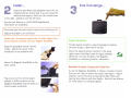
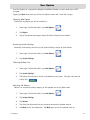
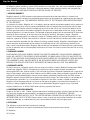
Check the Contents...
o
o
o
o
o
o
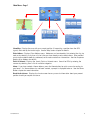
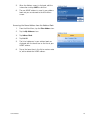
Magellan@ RoadMate™ 1212
Adjustable Mount
Basic Cradle
Adhesive Mounting Disk
Vehicle Power Adapter Cable
User Manual CD-ROM
The Magellan RoadMate has an internal battery that
may need to be charged the first time it is used.
The battery will begin charging as soon as power is
supplied to the Magellan RoadMate through the
vehicle power receptacle. (When the light on the
vehicle power adapter illuminates, it is properly
connected to 12 VDC. Note some vehicles require that
the ignition be on before power is delivered to the
vehicle power receptacle.)
Register your Magellan RoadMate at
www.magellangps.comlto keep updated on latest
offers and accessories.
© 2008 Magellan Navigation, Inc. All rights reserved.
The Magellan logo, Magellan, and Magellan RoadMate are
trademarks of Magellan Navigation, Inc.
2
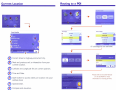
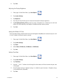
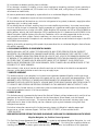
Install...
Turn it on and go...
Clean the area where the adjustable mount will be
installed with an alcohol pad. If you are using the
adhesive disk apply it firmly to a flat, smooth area
or the dash. (Allow to cure for 24 hours.)
See the User Manual on the CD-ROM for additional
information on installation.
Some areas have laws restricting the mounting of any devices on the
windshield. Be sure to check your local laws before mounting the
Magellan RoadMate to the windshield.
Please note: Accessories shown here may differ sl ightly from
the accessories provided with your Magellan RoadMate.
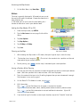
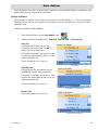
Snap the adjustable mount into the
cradle. Attach the mount to the
windshield or the adhesive disk.
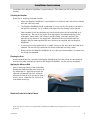
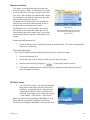
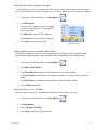
Signal Recepfon
For best signal reception, leave the garage or parking
structure to get a clear view of the sky.
Check the satellite status indicator in the upper
right corner of the Map screen for signal strength.
When the icon bars are green, the Magellan
RoadMate is computing position information.
•••1
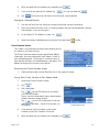
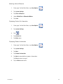
Attach the Magellan Road Mate to the
basic cradle.
Residents of Hawaii, Canada and Puerto Rico
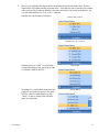
Plug one end of the vehicle power
adapter to USB connector on the
Magellan RoadMate and the other in a
vehicle power receptacle.
To use the Magellan RoadMate in Hawaii, Canada or Puerto
Rico you will need to select the proper map region. Region
selection can be found by accessing the Main Menu and
tapping User Options and then Region. See the User Manual
for more details on changing regions.
Thank you for your purchase of the
Magellan RoadMate 1212
Please do not return this product to the place of purchase
without first contacting Magellan Technical Support at
www.magellanGPS.com/support/.
For questions on using the Magellan RoadMate 1212, please
refer to the reference card or the CD-ROM supplied with this
product. If you are still unable to answer your question,
check our technical support web page at:
http://www.magellanGPS.com/su pport/
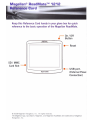
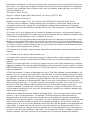
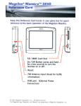
Ma ellan® RoadMate™ 1212
Reference Card
Keep this Reference Card handy in your glove box for quick
reference to the basic operation of the Magellan RoadMate.
, - - On / Off
•
Button
dlAGElLAII;,
SD / MMC
Card Slot
•
Reset
•
USB port.
(External Power
Connection)
•
.....
Maiellan Roadlllate
J
© 2008 Magellan Navigation, Inc. All rights reserved.
The Magellan logo, QuickSpell, Magellan, and Magellan RoadMate are trademarks of Magellan
Navigation, Inc.
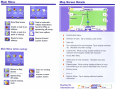
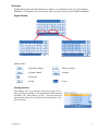
Map Screen Details
Main Menu
~-----'-A
.
Falrplex Dr
;:::======",!!!W~uuu~Jo
oilIrplex LX
t
View Map Screen
L.....,;.--,,-,
Create a route to an
address
Create a route to a
point of interest
Route to home
address
~:;:=.
Create a route with
multiple destinations
Search for POls on
approaching off-ramps
Select user options
Accesses Current
location Screen
E'0.6 mi
A
Current street name.
B
Direction of travel. Tap to display Locate screen.
C
Zoom out.
o
Main Menu (while routing)
;::;;~~
_11:...-.....
Return to Map
Screen
Search for POls on
approaching
off-ramps
Cancel existing
route
Detour on existing
route
Accesses Current
location Screen
Turn instructions for next manuever. Tap to display maneuver
list. (Available only when routing)
E
Current time. While routing, displays distance to next
maneuver and if tapped, repeats last manuever.
F
Access Main Menu.
G
Street name for next maneuver. (Available only when
routing)
H
Present speed. While routing, displays distance of route,
time remaining on the route or estimated time of arrival.
Volume control
J
Zoom in.
K
Satellite Status. Tap to display additional satellite
information.
Reading the
information bar
Right turn in 2.3 miles on Fairplex Dr. Arrive at final destination in 3.6 miles.
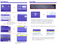
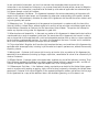
Satellite Signals
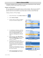
Routing to an Address by City
,
4 bars green: Strong signal
"
.
• mIB
Blank: No satellite signals.
Unable to compute position.
Xi~
,
-,
Tap on the satell ite status
icon to get a visual
representation of the
satellites and signal strength.
GPS Status
F
---. , . .
. .. . ··· .
.
---+
~~mm
For detailed GPS information, access the MFG GPS Status screen.
Main Menu> User Options> GPS Options> GPS Status
Keypad: Type in the first
few characters of the city.
SlIfCt City HMn!
f"';'" :
Stltet Strtt1 Nimt
.~
--.,.
''''.'
.
.
-,
." .
~
"
I
~
1i@i~'
~
Keypad: Enter
the street
name. You do not need to add direction
prefixes (N, E, W, S, etc.) but
you can if desired to limit the
number of streets displayed.
.
700·199
Tips on improving satellite signal strength
. . Leave the garage or parking structure so the GPS receiver has a
clear view of the sky.
. . Move away from large structures or overhanging trees that may
interfere with satellite reception.
. . You may need to relocate the Magellan RoadMate in your vehicle
to have a better view of the sky.
This receiver may not be able to get satellite signals while indoors. If you
are not getting strong satellite signals, go outside and follow the tips
provided above.
The Map screen wi II be
displayed and you will be
provided routing instructions.
Please refer to the User Manual on the
CD-ROM for more information on using
the keypad and the QuickSpell®
feature of the Magellan RoadMate.
~
Planner
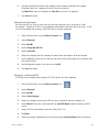
Exit POls
Exit POls can be accessed ONLY while travelling on a
freeway. If you try to use Exit POls while not on a freeway, a
warning will be displayed indicating that it is not available.
bit (ml)
II
II
II
01
•
Trip tum.
POOlS _THURS
C
A
K
Q
R
M",.
G
0
T
H
M
N
0
P
U
V
W
X
123
1.'
~
'.';lII;"
."~:.
oJ.
",II.
~_.t.~.t4
~-_.
7';',41
iii
"
~ L:e'
4<-",,"
"
!!I
!!I
..~ .:-~
""",.&
,,~- .
, ' t - '.
*0
1ilf
.~-
I
Use Address, Address
Book,POls or Intersection to
select destination.
Add idltfSS to Trip
0'
•• ....
• .
Se!tdbil
Repeat
New Trip: POOlSJHURS
4711 N.lOldo1 Av', 011<090, (an,,1
The Magellan RoadMate takes the upcoming exits and
computes which restaurants, gas stations, and hotels are
near the exit. If there are no POls for a category near
the exit, the icon for that category will not be shown.
Tap on the icon for the category and the exit you want to use:
POl""""
, 'hi
'toH9IJmJ
61Oi'I ..... An
\.M~c.u...u
~
I 05.
!lol! WMI'tr Itlll
SMlIliIai\(iIlbtN
'1M ~ ow
"""
....
....
'm
Gas stations at 0.2 mi exit
Food at 0.2 mi exit
Tapping on a POI in the list brings up the Route Method
screen, To create a route to the POI chosen, tap on the
orange "Calculate Route" icon.
Use the 'Guide Me' button to
access this trip.
Current Location
Current location
Routing to a POI
"I<! SUb ""9"Y
Afuo r.oo
_r.oo
1oI,,_r.oo
...... r.oo
Austrian food
(if subcategories are available)
I
i
I 00",
A
Current street or highway and current city.
B
Next and previous exit or intersection from your
current location.
C
Latitude and Longitude for your current position.
o
Time and Date.
E
Save button to quickly store your location into your
address book
F
Speedometer.
G
Compass and elevation.
I'JOOO Ii Aiporl DI
480 fJlll 10JO
XollWle.JJ _
Please refer to the User Manual
on the CD-ROM for more
information on routing to POls.
J
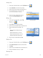
User Options. System Settin~.s
Volume: Tap 'Mute' to turn the speaker on or off.
Tap on the slider bar to change the speaker volume.
Brightness: Tap on the slider bar to change the
display brightness. Select 'On-battery dimming
(75%)' to conserve battery life while not connected
to external power.
Power: Select the duration that the receiver will turn
off if not moving or the touchscreen is not touched.
Time Zone: Choose your local time zone. Select
'Daylight Savings' when applicable to your area.
(Note: the Magellan RoadMate does not automatically change the daylight savings setting.)
Units of Measure: Select either 'Miles/Feet' or
'Kilometers/Meters' to assign the units of measure.
System Status: Tap the 'Next' button to access the
System Status where you can view product
information or ru n diagnostics.
605-0169-001 A
_
Magellan®
RoadMate™ 1212
User Manual
Magellan Navigation, Inc. 960 Overland Court, San Dimas, CA 91773
IMPORTANT SAFETY WARNINGS
The Magellan RoadMate is a vehicle-navigation aid designed to assist you in arriving to your selected destinations. When
using the Magellan RoadMate, these safety rules must be followed to prevent accidents that can result in injury or death to
yourself or others:
•
•
•
•
•
•
•
California and Minnesota law prohibits mounting any item to your windshield. Please check with your state or local law
enforcement for applicable regulations regarding windshield mounting. Go to www.magellanGPS.com for alternate
mounting solutions. An adhesive disk is supplied with the Magellan RoadMate for use as an alternate mounting solution
to the dashboard.
When driving, the need to view the display is minimal. The driver should enter data or program the Magellan RoadMate
only when the vehicle is stopped. Only a vehicle passenger should enter data or program the Magellan RoadMate while
the vehicle is moving.
It is your responsibility to comply with all traffic laws.
Every attempt is made to ensure that the database is accurate. However, roadways, points of interest (POIs), and
business and service locations may change over time. The database does not include, analyze, process, consider, or
reflect any of the following: legal restrictions (such as vehicular type, weight, height, width, load and speed restrictions);
road slope or grade; bridge height, width, weight, or other limits; population density; neighborhood quality or safety;
availability or proximity of law enforcement, emergency rescue, medical, or other assistance; construction work zones or
hazards; road or lane closures; road, traffic, or traffic facilities’ safety or condition; weather conditions; pavement
characteristics or conditions; special events; traffic congestion. It is your responsibility to disregard any unsafe,
hazardous, or illegal route suggestions.
Keep the Magellan RoadMate safe from extreme temperature conditions. For example, do not leave it exposed to direct
sunlight for an extended period of time.
Take care when mounting the Magellan RoadMate in your vehicle, whether using the windshield mount or other
mounting accessories, that it does not obstruct the driver's view of the road, interfere with the operation of the vehicle's
safety devices such as air bags, or present a hazard to occupants of the vehicle should the Magellan RoadMate be
dislodged while driving. You assume the risks associated with damage to your vehicle or vehicle occupants as the result
of your choices in mounting the Magellan RoadMate.
The battery in the Magellan RoadMate is rechargeable and should not be removed. In the event it should need to be
replaced, please contact Magellan Technical Support.
About Charging the Magellan RoadMate
•
•
•
•
An optional AC adapter is available as an accessory for your Magellan RoadMate. Use of another type of AC adapter can
result in malfunction and/or possible fire hazard due to battery over heating.
Use only the vehicle power cable approved for / supplied with your Magellan RoadMate. Use of another type of vehicle
power cable will result in malfunction and/or damage to the receiver.
For safety reasons, the battery in your Magellan RoadMate will stop charging when the ambient temperature is less than
32°F (0°C) or more than 113°F (45°C).
It will take approximately 6 hours of charging the Magellan RoadMate through the vehicle power adapter or optional AC
adapter to obtain a full battery charge.
About the Battery
•
•
Do not attempt to replace the battery. Please contact Magellan Technical Support for issues related to the battery.
Use only the charger approved for your Magellan RoadMate.
i
IMPORTANT SAFETY WARNINGS
Federal Communication Commission Interference Statement
This equipment has been tested and found to comply with the limits for a Class B digital device, pursuant to Part 15 of the
FCC Rules. These limits are designed to provide reasonable protection against harmful interference in a residential
installation. This equipment generates, uses and can radiate radio frequency energy and, if not installed and used in
accordance with the instructions, may cause harmful interference to radio communications. However, there is no guarantee
that interference will not occur in a particular installation. If this equipment does cause harmful interference to radio or
television reception, which can be determined by turning the equipment off and on, the user is encouraged to try to correct
the interference by one of the following measures:
•
•
•
•
-Reorient or relocate the receiving antenna.
-Increase the separation between the equipment and receiver.
-Connect the equipment into an outlet on a circuit different from that to which the receiver is connected.
-Consult the dealer or an experienced radio/TV technician for help.
This device complies with Part 15 of the FCC Rules. Operation is subject to the following two conditions: (1) This device
may not cause harmful interference, and (2) this device must accept any interference received, including interference that
may cause undesired operation.
FCC Caution: Any changes or modifications not expressly approved by the party responsible for compliance could void the
user's authority to operate this equipment.
IMPORTANT NOTE:
FCC Radiation Exposure Statement:
This equipment complies with FCC radiation exposure limits set forth for an uncontrolled environment. End users must
follow the specific operating instructions for satisfying RF exposure compliance.
This transmitter must not be co-located or operating in conjunction with any other antenna or transmitter.
In order to maintain compliance with FCC regulations, shielded cables must be used with this equipment. Operation with
non-approved equipment or unshielded cables is likely to result in interference to radio and TV reception. The user is
cautioned that changes and modifications made to the equipment without the approval of manufacturer could void the user's
authority to operate this equipment.
The Magellan RoadMate must be installed and operated at a distance no closer then 8 inches (20 cm) from the user.
This Class B digital apparatus meets all requirements of the Canadian Interference-Causing Equipment Regulations.
Cet appareil numerique de la classe B respecte toutes les exigences du Reglement sur le materiel brouilleur du Canada.
ii
IMPORTANT SAFETY WARNINGS
IC statement
Operation is subject to the following two conditions:
1.
2.
This device may not cause interference and
This device must accept any interference, including interference that may cause undesired operation of the
device.
IMPORTANT NOTE:
IC Radiation Exposure Statement:
This equipment complies with IC radiation exposure limits set forth for an uncontrolled environment. End users must follow
the specific operating instructions for satisfying RF exposure compliance.
This transmitter must not be co-located or operating in conjunction with any other antenna or transmitter.
The information provided in this document is subject to change without notice. Improvements and enhancements to the
product may occur without any formal notification. Check the Magellan website (www.magellanGPS) for product updates
and additional information.
© 2008 Magellan Navigation, Inc. All rights reserved. The Magellan Logo, Magellan, Magellan RoadMate, TrueView,
SmartDetour, and SmartVolume are trademarks of Magellan Navigation, Inc. No part of this user manual may be reproduced
or transmitted in any form or by any means, electronic or mechanical, including photocopying and recording, for any purpose
other than the purchaser’s personal use, without the prior written permission of Magellan Navigation, Inc.
604-0132-001 A
iii
Table of Contents
Magellan RoadMate 1212 ........................................................................................... 1
Magellan RoadMate 1212 ....................................................................................... 2
Fundamentals ............................................................................................................. 3
Powering on the Magellan RoadMate ........................................................................ 3
Turning the Magellan RoadMate On ..................................................................... 3
Turning the Magellan RoadMate Off .................................................................... 3
Selecting Auto-Power Shutdown Time .................................................................. 3
Volume .................................................................................................................. 3
Changing the Volume from the Map Screen. ......................................................... 3
Changing the Volume from User Options .............................................................. 4
Brightness ............................................................................................................. 4
Accessing the Brightness Control ........................................................................ 4
The Main Menu ...................................................................................................... 4
Accessing the Main Menu ................................................................................... 4
.Main Menu - Page 1 ........................................................................................... 5
.Main Menu - Page 2 ........................................................................................... 6
The Keypad ........................................................................................................... 7
Keypad Overview ................................................................................................. 7
Special Keys ..................................................................................................... 7
Selecting From List .............................................................................................. 7
Notes on Entering Data ........................................................................................ 8
Installation Instructions ............................................................................................... 9
Selecting the Location ............................................................................................ 9
Cleaning the Area ................................................................................................... 9
Applying the Adhesive Disk ..................................................................................... 9
Attach the Cradle to the Swivel Mount ...................................................................... 9
Secure the Swivel Mount to the Windshield or Adhesive Disk .................................... 10
Attaching the Magellan RoadMate to the Cradle ...................................................... 10
Adjust the Mount for Optimum Viewing .................................................................. 10
Connecting Power ................................................................................................ 10
Check Connection and Final Adjustments ............................................................... 10
Security .............................................................................................................. 11
Region ................................................................................................................ 11
Map Screen .............................................................................................................. 12
Accessing the Map Screen ................................................................................ 14
2D Mode ........................................................................................................... 14
Table of Contents
Magellan RoadMate 1212
1
Setting the Map Modes (2D or 3D) .................................................................... 14
Panning on the Map ......................................................................................... 14
Saving a Position While Panning ....................................................................... 14
Routing to a Panned Position ............................................................................ 15
Current Location Screen ....................................................................................... 15
Accessing the Current Location Screen .............................................................. 15
Saving Your Current Location to Your Address Book ............................................ 15
Maneuver List Screen ........................................................................................... 16
Accessing the Maneuver List ............................................................................. 16
Excluding a Maneuver ...................................................................................... 16
GPS Status Screen ............................................................................................... 16
Accessing the GPS Status Screen ..................................................................... 17
Zoom Levels ........................................................................................................ 17
Setting Zoom Levels ........................................................................................ 17
Volume ................................................................................................................ 17
Changing the Volume from the Map Screen. ....................................................... 17
Home Address .......................................................................................................... 18
Creating a Home Address ................................................................................. 18
Creating a Route to the Home Address ............................................................... 18
Changing the Home Address ............................................................................. 18
Accessing the Home Address from the Address Book .......................................... 19
Enter Address ........................................................................................................... 20
Entering an Address ............................................................................................. 20
Creating a Route to a New Address .................................................................... 20
My Addresses ....................................................................................................... 22
Accessing the My Addresses Menu .................................................................... 22
Previous Destinations ......................................................................................... 22
Routing to a Previous Destination (Method 1) ..................................................... 22
Routing to a Previous Destination (Method 2) ..................................................... 23
Saving a Previous Destination to Your Address Book ............................................ 23
Deleting a Previous Destination ......................................................................... 23
Address Book .................................................................................................... 24
Accessing an Address in Your Address Book ....................................................... 24
Routing to an Address in Your Address Book ...................................................... 24
Editing an Address in Your Address Book. .......................................................... 24
Deleting an Address in Your Address Book. ........................................................ 24
Favorites ........................................................................................................... 24
Accessing an Address from Favorites ................................................................. 25
Table of Contents
Magellan RoadMate 1212
2
Routing to an Address from Your Favorites List ................................................... 25
Editing an Address from Your Favorites List ....................................................... 25
Deleting an Address from Your Favorites List ...................................................... 25
Creating a New Entry ......................................................................................... 25
Creating a New Entry to You Address Book by Selecting on the Map ..................... 25
Creating a New Entry to You Address Book by Entering an Address ....................... 26
Creating a New Entry to You Address Book from a POI ........................................ 26
Creating a New Entry to You Address Book from by Intersections .......................... 27
Intersection ......................................................................................................... 27
Creating a Route to Two Intersecting Streets ...................................................... 27
Points of Interest (POI) .............................................................................................. 29
Categories and Subcategories ................................................................................ 29
Creating a Route to a POI by Category ............................................................... 29
Creating a Route to a POI by Name ................................................................... 30
Enhanced POIs .................................................................................................... 30
Loading a POI File ........................................................................................... 30
Selecting Categories for Display on the Map ....................................................... 31
Setting Alarms ................................................................................................ 31
Setting Alarm Parameters ................................................................................. 32
Routing to an Enhanced POI ............................................................................. 32
Saving an Enhanced POI to Your Address Book .................................................. 33
Travelling on a Route ................................................................................................ 34
Map Screen ......................................................................................................... 34
Split-Screen ...................................................................................................... 34
Maneuver List .................................................................................................... 34
You Have Arrived ............................................................................................... 35
Types of Routes ................................................................................................... 35
Route Method ...................................................................................................... 35
Special Routing Functions .................................................................................... 36
Routing to a POI Near an Approaching Freeway Exit ............................................ 36
Cancelling a Route .......................................................................................... 36
Detouring off a Route ....................................................................................... 36
Changing the Route Method ............................................................................. 37
Trip Planner ............................................................................................................. 38
Creating a Trip ................................................................................................ 38
Optimizing a Trip ............................................................................................. 39
Starting a Trip ................................................................................................. 40
Editing a Trip .................................................................................................. 40
Table of Contents
Magellan RoadMate 1212
3
Deleting a Trip ................................................................................................ 40
Renaming a Trip .............................................................................................. 40
Exit POIs .................................................................................................................. 42
Routing to a POI Near an Approaching Freeway Exit ............................................ 42
User Options ............................................................................................................ 43
Selecting Map Region ...................................................................................... 43
Accessing System Settings ............................................................................... 43
Checking Battery Life ....................................................................................... 43
Adjusting the Volume ....................................................................................... 43
Adjusting the Display Brightness ....................................................................... 44
Setting Auto Power Off Time ............................................................................. 44
Setting Time Zone ........................................................................................... 44
Selecting Units of Measure ............................................................................... 45
Displaying Contact Us Information .................................................................... 45
Displaying Product Information ......................................................................... 45
Performing Diagnostics .................................................................................... 46
Accessing the Trip Computer ............................................................................ 46
Selecting POIs to be Displayed on the Map ........................................................ 47
Deleting Addresses from the Address Book (Global) ............................................ 47
Setting the Map in 3D or 2D Mode .................................................................... 47
Setting the Map Display to Heading Up or North Up ........................................... 48
Setting Split Screen (TrueView™) Options ......................................................... 48
Setting Auto Night Map Display ........................................................................ 48
Setting Detour Options ..................................................................................... 49
Using the Simulator ......................................................................................... 49
Setting Tone Options ....................................................................................... 50
Setting Text-To-Speech Use .............................................................................. 50
Viewing Technical GPS Information ................................................................... 50
Setting the GPS Position .................................................................................. 51
Backing Up and Restoring Data ........................................................................ 51
Backing Up Data ............................................................................................. 51
Restoring Data ................................................................................................ 51
Viewing Map Information .................................................................................. 52
Table of Contents
Magellan RoadMate 1212
4
Magellan RoadMate 1212
The Magellan RoadMate 1212 is a vehicle navigation product that utilizes GPS signals from satellites
to calculate your precise location and compute details about its travel. Knowing its position and
movement, it can then overlay this information on detailed maps provided by NAVTEQ® to provide a
visual representation of your location.
With the Magellan RoadMate 1212 you can:
•
Store your home address and quickly get routing details to your home.
•
Create and save addresses in your address book that can be accessed at any time and get
routing information to that address.
•
Route to an address that you enter using the keypad and Magellan’s QuickSpell feature for
easy, errorless address entry.
•
Route to any point of interest (POI) that has been preloaded into your Magellan RoadMate.
•
Route to a POI that appears on the map while traveling simply by tapping on the POI icon.
•
Route to an intersection by selecting the intersecting streets.
•
Create a trip with multiple destinations using the trip planner. Handy for business people
who need routing information to many destinations.
•
View POIs that are ahead of you on the freeway. The exit POI function provides you with a
list of gas stations, restaurants, hotels and auto repair shops located nearby exits you are
approaching while traveling on a freeway.
•
Customize your Magellan RoadMate to meet your needs using the User Options menu.
The interface for the Magellan RoadMate is easy and simple to follow once you understand the basics.
You may never need to refer to this manual but if you do we have tried to present it in a form that you
can access the function you are trying to complete and follow the steps provided.
The Magellan RoadMate has a built-in battery so in most cases you will be able to follow these
instructions while reading them on your computer screen without plugging the Magellan RoadMate to
AC power. You should note that while indoors you may not get any satellite signals so your location
information would not be updated. However, the Centrality™ chipset installed in the Magellan
RoadMate will get satellite signals in some very rough locations so you may notice the Magellan
RoadMate computing a position, even indoors.
This document is set up to be printed on 8.5” x 11” (letter) paper should you desire a printed version
for your reference.
Magellan RoadMate 1212
1
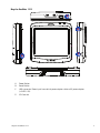
Magellan RoadMate 1212
A
B
D
C
A
Power Button
B
Reset Button
C
USB connector. Power input from vehicle power adapter cable or AC power adapter
(+5 VDC / 2A).
D
SD Card slot
Magellan RoadMate 1212
2
Fundamentals
Powering on the Magellan RoadMate
The On/Off button is located on the bottom right side of the Magellan RoadMate as shown in the
Overview chapter.
Turning the Magellan RoadMate On
1.
Press and hold the On/Off button for 1-2 seconds.
2.
Read the Warnings and tap OK.
Turning the Magellan RoadMate Off
1.
Press and hold the On/Off button for 1-2 seconds.
Selecting Auto-Power Shutdown Time
The Magellan RoadMate can be set up to shut down automatically using the time durations you can
select. The receiver will turn off after the selected duration has passed when; A) the position hasn’t
changed and B) the touchscreen hasn’t been pressed.
1.
Access the Main Menu.
2.
Tap the Next arrow to access the Main Menu Page 2.
3.
Tap User Options.
4.
Tap System Settings.
5.
Tap Power.
6.
Select Auto-Power Off time; Never, 10 Minutes, 20 Minutes or 30 Minutes.
7.
Tap Save.
8.
Tap the Back arrow to return to the Main Menu.
Volume
There are two ways to access the volume controls; one is tapping the speaker icon on the Map screen
and the other is through User Options.
Changing the Volume from the Map Screen.
1.
Tap the speaker icon
.
2.
Tap on the Mute button to mute the volume or tap inside the volume adjust bar below the
Mute button to change the volume levels.
3.
Tap
.
If you have the volume muted the speaker icon is displayed with a line through it indicating it is
muted. To unmute, tap the speaker icon again and the Magellan RoadMate will automatically
unmute. To make any other adjustments to the volume, press the speaker icon again.
Fundamentals
3
Changing the Volume from User Options
1.
Access the Main Menu.
2.
Tap the Next arrow to access the Main Menu Page 2.
3.
Tap User Options.
4.
Tap System Settings.
5.
Tap Volume.
6.
Tap on the Mute button to mute the volume or tap inside the volume adjust bar below the
Mute button to change the volume levels.
7.
Tap
.
Brightness
Accessing the Brightness Control
1.
Access the Main Menu.
2.
Tap the Next arrow to access the Main Menu Page 2.
3.
Tap User Options.
4.
Tap System Settings.
5.
Tap Brightness.
6.
Tap inside the brightness adjust bar to set the desired brightness.
7.
Tap
.
On the Brightness screen there is a checkbox for “On-battery dimming (75%)” When checked, the
Magellan RoadMate will dim to 75% of the brightness when operating exclusively on battery power.
This prolongs the battery life between charges. It can be turned off by tapping on the checkbox.
The Main Menu
The Main Menu screen is the center for all the available functions for the Magellan RoadMate. The
Main Menu consists of two pages with large, easy to access icons.
Accessing the Main Menu
From the Map screen tap the Menu button.
From the other screens, tap the Back button.
Fundamentals
4
.Main Menu - Page 1
Show Map: Displays the map with your current position (if computing a position from the GPS
signals) indicated by the blue triangle. See the Map Screen chapter for details.
Enter Address: Displays Enter Address menu. Addresses can be entered by first entering the city, zip
code, or by selecting a city from a list of cities you have already used as destinations. Also provides
access to your address book (my addresses) or to create a route to an intersection. See the chapter on
Routing to an Address for details.
Points of Interest: Displays the Search Points of Interest menu. Search for POIs by entering the
name or by selecting from a list of available categories.
Home: If you have created a Home address, press the Home button for quick access for routing to
your home. If a Home address has not been created, a prompt is displayed to do so. See the Home
Button chapter for more information.
Roadside Assistance: Displays the Locate screen for easy access to information about your present
position should you require assistance.
Fundamentals
5
.Main Menu - Page 2
Trip Planner: Opens the Trip Planner menu where you can create, edit, delete, rename or activate a
trip.
Exit POI’s: (Accessible only while on a freeway.) Provides a listing of restaurants, gas stations, or
hotels near approaching freeway exits. You can select one of the POIs presented and create a route to
it.
User Options: Accesses the User Options menu. This menu can be used to access functions used to
customize the Magellan RoadMate to your personal needs.
Home: If you have created a Home address, press the Home button for quick access for routing to
your home. If a Home address has not been created, a prompt is displayed to do so. See the Home
Button chapter for more information.
Roadside Assistance: Displays the Locate screen for easy access to information about your present
position should you require assistance.
Fundamentals
6
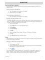
The Keypad
Understanding the keypad while entering an address is an important part of using your Magellan
RoadMate. The keypad is the most common means of entering data into the Magellan RoadMate.
Keypad Overview
Special Keys
Alphabetic Keypad
Numeric Keypad
Symbols Keypad
Spacebar
Backspace
Accept
Cancel
Selecting From List
After tapping “OK” to accept your input you may get a list of
items found in the database. The sample here shows the result
of tapping “OK” after entering “LOS A”. Use the scroll bar to
move up and down the list and tap on the desired item in the
list to continue.
Fundamentals
7
Notes on Entering Data
If you are having trouble getting the results you expected here are a few useful tips.
•
Make sure that you have spelled the name correctly. If you are unsure of the spelling, just
enter a few characters and tap “OK”. A long list of names will be displayed but you can
step through the list and probably be able to find the correct spelling.
•
Check for apostrophes and hyphens. If you are not seeing the POI you are looking for in
the POI list, check to see if the name has an apostrophe or hyphen.
•
When entering a street name you can use the street prefix (N. E. W. S. etc.) to narrow the
search. For example to find N. Main St. you could enter “N. Main” or “N Main”.
•
The more characters you enter, the smaller the list of possible options from which to
choose.
Fundamentals
8
Installation Instructions
Installation of the Magellan RoadMate is simple and easy. The hardest part will be picking the best
location.
Selecting the Location
A few tips on selecting the proper location.
•
Mount the Magellan RoadMate in a place where it can be easily seen and will not interfere
with your view of the road.
•
The Magellan RoadMate should be mounted in such a way that the antenna, (located in
the top of the receiver), has an unobstructed view of the sky through the windshield.
•
Select whether it will be mounted using the adjustable mount to the windshield or an
adhesive disk. Be sure to check your local and regional laws before mounting to the
windshield. Some states, like California and Minnesota, have laws restricting the
mounting of any device on the windshield. (Adhesive Disks are available from the
Magellan Store at www.magellanGPS.com if one was not supplied with the Magellan
RoadMate.)
•
If planning to use the adhesive disk, a smooth surface on the dash board will need to be
selected. Do not attach the adhesive disk to the windshield nor airbag covers.
•
Make sure that the Magellan RoadMate nor any cabling will be disturbed in the event that
the airbags are deployed.
Cleaning the Area
Use the alcohol pad that came with the Magellan RoadMate to clean the area on the windshield or
dash that has been selected for mounting the Magellan RoadMate. Let the area dry completely.
Applying the Adhesive Disk
(Skip if mounting directly to the windshield.)
Remove the protective tape from the back of
the adhesive disk. Apply the disk with the
adhesive side towards the dash. Maintain
pressure on the disk for 5 minutes to allow it
to set in place. Allow the disk 24 hours to
cure before continuing.
Attach the Cradle to the Swivel Mount
Please note that the swivel mount supplied with the Magellan RoadMate may be different then the one shown in this
document.
Installation
9
Line up the two tabs on the swivel mount
with the holes on the back of the cradle.
Push the cradle down until it locks in place
with the swivel mount.
Secure the Swivel Mount to the Windshield or Adhesive Disk
Make sure that the lever at the base of the
adjustable mount is in the up position. Place
the base of the swivel mount firmly over the
area of the windshield to be used or the
adhesive disk. Push the lever at the base of
the swivel mount all the way down until it
snaps in place. Carefully let go of the
assembly, making sure that it is securely
mounted.
Attaching the Magellan RoadMate to the Cradle
Align the tabs on the cradle to the indents on the
bottom of the Magellan RoadMate. Swivel the
cradle up so that it is flush against the back of the
receiver and snap it into place.
Adjust the Mount for Optimum Viewing
Loosen the adjustment locking knobs and position the Magellan RoadMate for optimum viewing.
Once set, tighten the locking knobs. (Never attempt to adjust the mount while driving.)
Installation
10
Connecting Power
Plug the end of the cigarette lighter adapter into a
12 VDC vehicle power receptacle. Connect the
other end of the cable to the Magellan RoadMate’s
USB connector as shown. If there is power at the
receptacle, the Magellan RoadMate will power on.
(Note: some vehicles apply power to the vehicle
power receptacle only when the ignition is on.)
Check Connection and Final Adjustments
If the power indicator light on the vehicle power cable connector is on, power is being supplied to the
Magellan RoadMate. If it is not on, check the cable connection to the vehicle power receptacle. If
the light is still not on, turn the vehicle’s ignition on.
Press the power button (located at the bottom right side of the RoadMate) and hold down for a few
seconds. The Magellan RoadMate will power on. Sit in a normal driving position and make any final
adjustments to the swivel mount for optimum viewing. Tighten the adjusting knobs on the swivel
mount to hold the Magellan RoadMate firmly in place.
Press the power button again to turn the Magellan RoadMate off and turn the ignition switch to the
vehicle to off. The Magellan RoadMate is connected and ready for use.
Security
It is recommended that the Magellan RoadMate is not left in plain view while unattended for reasons
of theft.
Please note that the Magellan RoadMate is a receiver only and does not transmit GPS location
signals. The receiver nor the vehicle can be tracked using the Magellan RoadMate.
Region
By default, the Magellan RoadMate has the region setting for the lower 48 United States. When the
receiver is turned on for the first time it may ask you to assign regions. Select the map region you
want to use by tapping on the item from the list.
If you are travelling in other regions you will need to change the map region by using the following
steps.
1
From the Main Menu, tap on the right arrow to access the second page of the Main Menu.
2
Tap on User Options.
3
Tap on Region.
4
Tap on the map region desired.
The Region option will display the map regions that are available for the Magellan RoadMate you are
using.
Installation
11
Map Screen
The most commonly used screen will be the Map screen. Whether on a route or just travelling around
town, chances are the Map screen will be displayed. There are two unique modes that the Map
screen can be displayed in; normal and routing.
In normal mode, your position is shown on the map along with the time and your speed. As you
travel, your position will be updated, giving you a clear view of your position and surrounding streets.
A
B
K
C
J
D
I
E
F
G
H
Map Screen - Normal Mode
A
Street name currently on.
B
Direction indicator. Tap to view the Current Location screen where you can save your
position into your Address Book.
C
Zoom out
D
POI icon. Sample shown here is for a gas station. Tap on the POI icon to create a route to
that POI. Note: If there are multiple POIs in the same area, a list of those POIs will be
displayed. Tap on the name in the list to access the routing function.
E
Current position icon
F
Time of day
G
Main Menu button. Tap to display the Main Menu.
H
Current speed of travel
I
Volume control. Tap to display the Volume Setting screen where the loudness can be
adjusted or muted. (If the volume has been muted, tapping this button unmutes the volume
without displaying the Volume Setting screen.)
J
Zoom in
K
Satellite Status. All four bars in green is optimal. Tap to display the GPS Status screen.
Map Screen
12
In routing mode additional information is displayed providing detailed information about the route
you’ve selected.
A
B
N
C
M
D
L
E
K
J
F
G
H
I
Map Screen - Routing Mode
A
Street name currently on.
B
Direction indicator. Tap to view the Current Location screen where you can save your
position into your Address Book.
C
Zoom out
D
POI icon. Sample shown here is for a gas station. Tap on the POI icon to create a route to
that POI. Note: If there are multiple POIs in the same area, a list of those POIs will be
displayed. Tap on the name in the list to access the routing function.
E
Current position icon
F
Next maneuver icon. Tap on the icon to display the Maneuver List screen.
G
Distance to next maneuver. Tap to repeat the last voice command.
H
Main Menu button. Tap to go to the Main Menu screen. Note that the Main Menu screen is
different when there is an active route. See the chapter on Routing for details.
I
Tap to toggle between distance remaining to reach destination, approximate time remaining
until the destination is reached and the approximate the time of day to arrive at the
destination.
J
Street name for the next maneuver
K
Graphical representation of the route
L
Volume control. Tap to display the Volume Setting screen where the loudness can be
adjusted or muted. (If the volume has been muted, tapping this button unmutes the volume
without displaying the Volume Setting screen.)
M
Zoom in
N
Satellite Status. All four bars in green is optimal. Tap to display the GPS Status screen.
Map Screen
13
Accessing the Map Screen
1.
On the Main Menu, tap Show Map.
2D Mode
The map is normally displayed in 3D mode but you can set
the map to 2D mode if so desired. Choose the mode that is
best suited for you.
In 2D mode, you can pan across the map looking for a
location to route to or save in your address book.
Setting the Map Modes (2D or 3D)
1.
From the Map screen, tap MENU.
2.
Tap the Next arrow to access page 2 of the Main
Menu.
3.
Tap User Options.
4.
Tap Map Options.
5.
Tap 3D Map or 2D Map.
6.
Tap Save.
Map Screen in 2D Mode
Map Screen in 3D Mode
Panning on the Map
1.
While viewing the Map screen in 2D mode, slide your finger or stylus across the map.
2.
The location icon changes to
. (The circle is the crosshairs for a position and the red
arrow points to your current location.
3.
To exit panning, tap
and the map is returned to your current position.
Saving a Position While Panning
1.
Pan the map until the icon crosshairs are over the location you want to save to your address
book. (Must be a position that is does not have a POI icon displayed.)
2.
Tap in the center of the icon circle. (If nothing happens then you are not zoomed in enough.
Tap the zoom in icon and try again.)
3.
On the Route To This Address? screen, tap
4.
Edit Information:
Tap
on the Edit Name line to create a name for this location.
Tap on any of the three (work, home, mobile) phone buttons to enter a phone number.
Tap
on the Edit Information line to add additional information. (Up to 35
characters can be entered.)
5.
If you want to tag this location as one of your favorites, tap on the “Favorite” check box.
Map Screen
.
14
6.
When the details for this address are acceptable, tap
7.
If you want to now route to this address tap
8.
Tap
.
or if you are done tap
.
to exit panning and return the icon to your current position.
Routing to a Panned Position
1.
Pan the map until the icon crosshairs are over the location you want to route to.
2.
Tap in the center of the icon circle. (If nothing happens then you are not zoomed in enough.
Tap the zoom in icon and try again.)
3.
On the Route To This Address? screen, tap
4.
Select the routing method desired and tap the Calculate Route
,
button.
Current Location Screen
This screen is accessed from the Map screen whether you are
on a route or just normal driving.
The Current Location screen displays approximate address
information, the next and previous cross streets, as well as
your latitude/longitude. To the right is a compass point in
your direction of travel, calculated elevation, and speed. The
bottom bar displays the current time and date.
Accessing the Current Location Screen
1.
From the Map screen, tap the direction icon in the upper left corner.
Saving Your Current Location to Your Address Book
1.
Access the Current Location screen.
2.
Tap
3.
Edit Information:
Tap
on the Edit Name line to create a
name for this location.
Tap on any of the three (work, home, mobile) phone
buttons to enter a phone number.
Tap
on the Edit Information line to add
additional information. (Up to 35 characters can
be entered.)
4.
If you want to tag this location as one of your
favorites, tap on the “Favorite” check box.
5.
When the details for this address are acceptable, tap
Map Screen
Saving Current Location
.
15
Maneuver List Screen
This screen is accessed from the Map screen and
only when routing. (Note: The Maneuver List screen
is not available until you begin moving on the route.)
Each line in the maneuver list provides details about
the maneuver in the order that they are to be made,
with the next maneuver at the top.
The bottom bar of the Maneuver List indicates the
distance and time to the next maneuver as well as
the total distance computed for the route.
Maneuver List
The Maneuver List can be modified if you want to
exclude one of the maneuvers should you want to
avoid travelling one of the streets listed. Instructions
to exclude one of the maneuvers is described in this
chapter.
The maneuver highlighted indicates that you
will be instructed to make a left turn in 0.3
miles on CA-57 S
Accessing the Maneuver List
1.
Tap the maneuver icon in the lower left corner of the Map screen. This icon is displayed only
while on an active route.
Excluding a Maneuver
This is used to modify the route to possibly avoid routing on a particular street.
1.
Access the Maneuver List.
2.
Tap on the item in the list with the street you want to try and avoid.
3.
Confirm the exclusion by tapping on
4.
The Magellan RoadMate recalculates the route and displays the Maneuver List with the
newly computed maneuvers.
. (Tap the back arrow to cancel.)
GPS Status Screen
1.
The GPS Status screen is also accessed from the
Map screen and displays the status of the GPS
satellites in a graphical format. (More technical
information on the GPS status can be found in
under the User Options menu: Main Menu Page 2
> User Options > GPS Options > GPS Status.)
Green bars indicate that the Magellan RoadMate is using
these satellites to compute the position; orange bars
indicate that the Magellan RoadMate is trying to lock on to
GPS Status Screen
Map Screen
16
the satellite signal; and no bar shown indicates a satellite that is not being tracked. The longer the
bars, the better the signal.
Accessing the GPS Status Screen
1.
From the Map screen, tap the GPS Signal Strength icon in the upper right corner.
Tap on the back arrow to return to the Map screen.
Zoom Levels
There are 23 zoom levels in the Magellan RoadMate, ranging from 100 feet to 1200 miles. Select the
zoom level that best suits your needs.
Setting Zoom Levels
1.
While viewing the Map screen, tap on the
(zoom in) or
(zoom out).
Volume
The volume can be adjusted or muted from the Map screen. (The volume can also be adjusted from
User Options > System Settings > Volume.)
Changing the Volume from the Map Screen.
1.
Tap the speaker icon
.
2.
Tap on the Mute button to mute the volume or tap inside the volume adjust bar below the
Mute button to change the volume levels.
3.
Tap
.
If you have the volume muted the speaker icon is displayed with a line through it indicating it is
muted. To unmute, tap the speaker icon again.
Map Screen
17
Home Address
Your home address can be entered and saved in the Magellan RoadMate for quick and easy access
when you need to create a route home.
Creating a Home Address
These instructions only apply if you have never entered a home address or if it has been deleted.
1.
Tap the Home Address icon
on the Main Menu screen.
2.
Confirm “Do you want to enter your HOME address?” Tap Yes.
3.
Follow the prompts to enter the address to be used as your HOME address.
4.
When the Address screen is displayed, edit the
information and top SAVE to continue.
5.
The HOME address is saved in your address book
and you are returned to the Main Menu screen.
Creating a Route to the Home Address
1.
Tap the Home Address icon
on the Main Menu screen.
2.
Tap Route.
3.
Select the Route Method desired and tap the
orange Calculate Route button.
Changing the Home Address
1.
Tap the Home Address icon
2.
Tap Change.
3.
Confirm “Do you want to replace the HOME address with a new address?” Tap Yes.
4.
Follow the prompts to enter the address to be used as your new HOME address.
Home Address
on the Main Menu screen.
18
5.
When the Address screen is displayed, edit the
information and top SAVE to continue.
6.
The new HOME address is saved in your address
book and you are returned to the Main Menu
screen.
Accessing the Home Address from the Address Book
1.
From the Main Menu, tap the Enter Address icon.
2.
Tap the My Addresses icon.
3.
Tap Address Book.
4.
Tap List All.
5.
The list of addresses in your address book are
displayed with the home icon on the line of your
HOME address.
6.
Tap on the home item in the list to create a route
to, edit or delete the HOME address.
Home Address
19
Enter Address
The Enter Address function is used to create a route from a newly entered address, an address in your
address book or to an intersection of two streets.
Entering an Address
While creating an address the first step is to indicate what city the address is in. This can be done by
inputting the name of the city, entering the zip code for the city or by selecting a city that has been
previously used.
Creating a Route to a New Address
1.
From the Main Menu, tap the Enter Address icon.
2.
Select the method to enter the city: Enter City, Enter Zip Code, or Previous City.
Enter City:
Use the keypad to enter the first few
characters of the city name. Tap OK to
display the list of cities found.
The button in the lower right corner is used
to select the sorting order of the list, by zip
code or alphabetically.
Tap on the desired city in the list.
List of Cities
Enter Zip Code:
Use the keypad the zip code for the city.
Tap OK when the zip code is complete.
The button in the lower right corner is used
to select the sorting order of the list, by zip
code or alphabetically.
Tap on the desired city in the list.
Cities with the Zip Code Entered
Previous City:
Tap on the desired city in the list.
List of Cities Previously Used
Enter Address
20
3.
With the city selected, the keypad will be displayed asking for the street name. Use the
keypad with QuickSpell to enter the street name. Enter the first few characters of the street
name and tap OK or continue entering characters until the list of streets is displayed. You
can use street prefixes (N, E, W, S, etc.) if desired.
Samples the city Pasadena, California:
Entering “ALLE” results in:
Entering “N A” or “N. A” results in:
Enter Address
However, typing in “NOR” can give some
unexpected results if you are trying to type
in the word “NORTH ALLEN”.:
Entering “NOR”
To resolve this, use the back arrow from the
street list and continue typing in the word
NORTH. Now all streets beginning with
“North” as well as streets with the north
prefix are displayed.
Entering “NORTH”
21
4.
Use the scroll bars to the right if necessary to view the name of the street desired. Tap on
the street name to continue.
5.
Use the keypad to enter the street number for
the address. Note in the top left corner is the
range of acceptable street numbers.
6.
Tap Done when the address is complete.
7.
Select the desired route method and tap the
orange Calculate Route button to begin routing.
My Addresses
My Addresses is where you store addresses that you want to keep as future destinations as well as
access addresses that you have gone to recently that may not be in your address book. The address
book can hold up to 100 addresses.
Accessing the My Addresses Menu
1.
From the Main Menu, tap the Enter Address icon.
2.
Tap on the my addresses icon.
3.
The My Addresses Menu is displayed.
Previous Destinations
Routing to a Previous Destination (Method 1)
1.
From the Main Menu, tap the Enter Address icon.
2.
Tap on the Previous Destinations icon.
3.
Select the destination from the list of previous destinations.
4.
Select the Route Method and tap the orange Calculate Route button.
Enter Address
22
Routing to a Previous Destination (Method 2)
1.
From the Main Menu, tap the Enter Address icon.
2.
Tap on the my addresses icon.
3.
Tap on Previous Destinations.
4.
Select the destination from the list of previous destinations.
5.
Tap on Route.
6.
Select the Route Method and tap the orange Calculate Route button.
Saving a Previous Destination to Your Address Book
1.
From the Main Menu, tap the Enter Address icon.
2.
Tap on the my addresses icon.
3.
Tap on Previous Destinations.
4.
Select the destination from the list of previous destinations.
5.
Tap on Edit.
6.
Apply any edits you want to make to this destination before saving.
7.
Check Favorite if you want this addresses store in your address book as a Favorite.
8.
Tap Save to store the address.
9.
The Previous Destination screen is displayed. Tap Route to route to this destination or the
Back arrow to return to the list of previous destinations.
Deleting a Previous Destination
1.
From the Main Menu, tap the Enter Address icon.
2.
Tap on the my addresses icon.
3.
Tap on Previous Destinations.
4.
Select the destination from the list of previous destinations.
5.
Tap on Delete.
6.
Confirm Deletion. Tap Yes.
7.
The Enter Address Menu will be displayed.
Enter Address
23
It is possible to delete all of the destinations in the Previous Destination List by accessing User
Options > Address Book Options > Clear Previous.
Address Book
Accessing an Address in Your Address Book
1.
From the Main Menu, tap the Enter Address icon.
2.
Tap on the my addresses icon.
3.
Tap on Address Book
4.
Tap List All to view the entire contents of your address book or tap on Search Address Book
to search for entries by searching on the name.
5.
From the list of addresses found, tap on the address record desired.
Routing to an Address in Your Address Book
1.
Access the address record from your address book as described in Accessing an Address in
Your Address Book.
2.
Tap on Route.
3.
Select the Route Method and tap on the orange Calculate Route button to continue.
Editing an Address in Your Address Book.
1.
Access the address record from your address book as described in Accessing an Address in
Your Address Book.
2.
Tap on Edit.
3.
Use the Edit Address Book screen to modify the name, information or phone numbers. The
street address cannot be changed.
4.
Tap Save when done.
Deleting an Address in Your Address Book.
1.
Access the address record from your address book as described in Accessing an Address in
Your Address Book.
2.
Tap on Delete.
3.
Confirm deletion. Tap Yes.
4.
You are returned to the list of addresses in your address book. If the list is now empty, you
are returned to the previous screen.
Favorites
Enter Address
24
Favorite addresses operate the same as other addresses in your address book. Addresses in your
address book can be marked as favorites to speed up the search for commonly used addresses.
Accessing an Address from Favorites
1.
From the Main Menu, tap the Enter Address icon.
2.
Tap on the my addresses icon.
3.
Tap on Favorites
4.
From the list of addresses found, tap on the address record desired.
Routing to an Address from Your Favorites List
1.
Access the address record from your Favoites as described in Accessing an Address from
Favorites.
2.
Tap on Route.
3.
Select the Route Method and tap on the orange Calculate Route button to continue.
Editing an Address from Your Favorites List
1.
Access the address record from your Favoites as described in Accessing an Address from
Favorites.
2.
Tap on Edit.
3.
Use the Edit Address Book screen to modify the name, information or phone numbers. The
street address cannot be changed.
4.
Tap Save when done.
Deleting an Address from Your Favorites List
1.
Access the address record from your Favoites as described in Accessing an Address from
Favorites.
2.
Tap on Delete.
3.
Confirm deletion. Tap Yes.
Creating a New Entry
This is used to create a new address and save it in your address book. You can create an entry by
selecting it on the map, entering the address, selecting an address from the list of POIs or choosing a
street intersection.
Creating a New Entry to You Address Book by Selecting on the Map
Enter Address
25
1.
From the Main Menu, tap the Enter Address icon.
2.
Tap on the my addresses icon.
3.
Tap on Create New Entry.
4.
Tap on Select on Map.
5.
The Map screen is displayed in 2D mode. Use your finger or stylus to pan around the map.
When the crosshair icon is over the location you want to add to your address book, tap in the
center of the crosshairs. (Note: you may need to zoom into a lower zoom level if the edit
Address Book screen is not displayed.)
6.
Edit the name, information and phone numbers for the location you selected on the map.
Tap the Favorites checkbox if you want this saved as a favorite address.
7.
Tap Save.
Creating a New Entry to You Address Book by Entering an Address
1.
From the Main Menu, tap the Enter Address icon.
2.
Tap on the my addresses icon.
3.
Tap on Create New Entry.
4.
Tap on Enter Address.
5.
Enter the address following the prompts. Detail on address entry can be found in this
chapter in the Entering an Address section,
6.
Edit the name, information and phone numbers for the location you selected on the map.
Tap the Favorites checkbox if you want this saved as a favorite address.
7.
Tap Save.
Creating a New Entry to You Address Book from a POI
1.
From the Main Menu, tap the Enter Address icon.
2.
Tap on the my addresses icon.
3.
Tap on Create New Entry.
4.
Tap on POIs.
5.
Select the category from the list of POI categories.
6.
If a subcategory list is displayed, select ALL Subcategories or one from the list.
Enter Address
26
7.
Select search criteria:
Near Current Position Displays POIs in the category selected nearest to your current
position. If no POIs are within a 50 mile radius, the search is empty and an alert displayed.
Near City: Enter a city name using the keypad (no QuickSpell) and select the city center
desired from the resulting list. This will display POIs in the category selected nearest to the
city center selected.(
Near Address: Enter an address using the standard address entry function. This will display
POIs in the category selected nearest to the address entered.
8.
Tap on the POI name desired from the list. Use the Prev and Next buttons to scroll up and
down the list.(
9.
Edit the name, information and phone numbers for the POI selected. Tap the Favorites
checkbox if you want this saved as a favorite address.
10. Tap Save.
Creating a New Entry to You Address Book from by Intersections
1.
From the Main Menu, tap the Enter Address icon.
2.
Tap on the my addresses icon.
3.
Tap on Create New Entry.
4.
Tap on Intersection.
5.
Select the city that the intersection is located in by entering the city name, entering the zip
code or selecting from the previous cities list.
6.
Search for the first street by spelling out the street name following the guidelines presented
in Entering an Address. Tap on the street from the list of streets.
7.
Search for the second street the same as in step 6. However, the Magellan RoadMate uses
QuickSpell to allow you to select only streets that intersect with the street selected in step
6. Tap on the intersecting street from the list of streets.
8.
Edit the name, information and phone numbers for the POI selected. Tap the Favorites
checkbox if you want this saved as a favorite address.
9.
Tap Save.
Intersection
Creating a Route to Two Intersecting Streets
1.
From the Main Menu, tap the Enter Address icon.
2.
Tap on the intersection icon.
Enter Address
27
3.
Select the city that the intersection is located in by entering the city name, entering the zip
code or selecting from the previous cities list.
4.
Search for the first street by spelling out the street name following the guidelines presented
in Entering an Address. Tap on the street from the list of streets.
5.
Search for the second street the same as in step 6. However, the Magellan RoadMate uses
QuickSpell to allow you to select only streets that intersect with the street selected in step
6. Tap on the intersecting street from the list of streets.
6.
Select the Route Method and tap on the orange Calculate Route button.
Enter Address
28
Points of Interest (POI)
The Magellan RoadMate has POIs preloaded that can be used as a destination for a route. Selecting
a restaurant or finding an ATM nearby is at your fingertips.
Categories and Subcategories
POIs are categorized into unique categories from gas stations to wineries. Most, but not all categories
are further organized into subcategories. Restaurants have, for example, 16 subcategories that
provide a way to search for restaurants serving Chinese food, or fast food, and even Swiss food.
Creating a Route to a POI by Category
1.
From the Main Menu, tap the Points of Interest icon.
2.
Select Search by Category.
3.
Use the scroll bars to view the categories
and tap on the desired category name.
Category List
4.
If a subcategory is displayed, use the the
scroll bars to view the subcategories and
tap on the desired subcategory name.
Select ALL SUBCATEGORIES if you are
unsure what subcategory best suits your
needs.
5.
Select the search criteria: Near Current
Position, Near What City? (requires entering
a city name) or Near Address (requires
entering an address).
6.
The top portion of the display shows
detailed information about the highlighted
POI in the list. The arrow and distance
indicates the direction and distance in a
straight line from your current position to
the POI.
Use the Prev and Next buttons to step up
and down the list of POIs found. Tap on the
POI name to continue.
7.
Select the route method and tap on the
orange Calculate Route button to begin.
Points of Interest
Sample Restaurant Sub Category List
Restaurants Near Current Position
29
Creating a Route to a POI by Name
1.
From the Main Menu, tap the Points of Interest icon.
2.
Select Search by Name.
3.
Spell the name of the POI to be used as the
destination. You need not enter the full
name, but the more characters you enter,
the easier it will be to find the exact POI
you are searching for.
4.
Select the search criteria: Near Current
Position, Near What City? (requires entering
a city name) or Near Address (requires
entering an address).
Sample Search by Name Input
5.
The top portion of the display shows
detailed information about the highlighted
POI in the list. The arrow and distance
indicates the direction and distance in a
straight line from your current position to
the POI.
Not that searching by name will show all
POIs that meet the name criteria,
regardless of category. In the sample
shown here, there are home improvement
Search Result for LOWE Near Position
centers (Lowe’s) and parks (Lowell Brandt
Park).
Use the Prev and Next buttons to step up and down the list of POIs found. Tap on the POI
name to continue.
6.
Select the route method and tap on the orange Calculate Route button to begin.
Enhanced POIs
Enhanced POIs are points of interest that are user-created using the POI Manager software found on
the CD-ROM. POI files created with the Magellan POI Manager software can be saved to the SD card
in the Magellan RoadMate.
Loading a POI File
1.
Save a POI file created with the Magellan POI Manager to an SD/MMC card installed in the
bottom of the Magellan RoadMate
2.
From the Main Menu, tap the Points of Interest icon.
3.
Select Enhanced.
4.
Select My POI.
Points of Interest
30
5.
Select Change My POI File.
6.
Select Select a POI File.
7.
Select the POI file to be loaded from the list of available POI files by tapping on the file
name.
Selecting Categories for Display on the Map
A POI file must be loaded (see Loading a POI File) for this function to operate.
1.
From the Main Menu, tap the Points of Interest icon.
2.
Select Enhanced.
3.
Select My POI.
4.
Select Change My POI FIle.
5.
Select Display Categories.
6.
Use the checkbox to the left of the category name to select or deselect the category.
(Checked means this category will have its icon displayed on the map.)
Tap Mark All to check all categories or Clear All to uncheck all categories.
7.
Tap Save when done.
Setting Alarms
A POI file must be loaded (see Loading a POI File) for this function to operate.An enhanced POI can
have an alarm that will alert you when you are in range set by “Alert Parameters.” Note that all
POIs in the categories selected will have their alarms set to on. A POI file must be loaded (see
Loading a POI File) for this function to operate.
1.
From the Main Menu, tap the Points of Interest icon.
2.
Select Enhanced.
3.
Select My POI.
4.
Select Change My POI FIle.
5.
Select Set Alarms.
Points of Interest
31
6.
Use the checkbox to the left of the category name to select or deselect the category.
(Checked means this category will have its alarms turned on.)
Tap Mark All to check all categories or Clear All to uncheck all categories.
7.
Tap Save when done.
Setting Alarm Parameters
An enhanced POI can have an alarm that will alert you when you are in range set by “Alert
Parameters.” Note that all POIs in the categories selected will have their alarms set to on. A POI
file must be loaded (see Loading a POI File) for this function to operate.
1.
From the Main Menu, tap the Points of Interest icon.
2.
Select Enhanced.
3.
Select My POI.
4.
Select Change My POI FIle.
5.
Select Set Alarms.
6.
Select the category from the category list whose alarm parameters are to be changed.
7.
Set the detection angle, the first warning and the last warning by tapping on the button with
the current setting.
8.
Use the keypad to enter in new values and tap OK.
9.
Tap Save when done.
Routing to an Enhanced POI
A POI file must be loaded (see Loading a POI File) for this function to operate.
1.
From the Main Menu, tap the Points of Interest icon.
2.
Select Enhanced.
3.
Select My POI.
4.
Select Select Category.
5.
Select the category containing the POI you want to route to from the category list.
6.
Select Nearest (near your current position) or Spell POI Name (requires entering the POI
name).
7.
Select the POI to be routed to from the “Select POI” list.
8.
Tap Route.
9.
Select the routing method desired and tap the orange Calculate Route button to continue.
Points of Interest
32
Saving an Enhanced POI to Your Address Book
A POI file must be loaded (see Loading a POI File) for this function to operate.
1.
From the Main Menu, tap the Points of Interest icon.
2.
Select Enhanced.
3.
Select My POI.
4.
Select Select Category.
5.
Select the category containing the POI you want to route to from the category list.
6.
Select Nearest (near your current position) or Spell POI Name (requires entering the POI
name).
7.
Select the POI to be routed to from the “Select POI” list.
8.
Tap Save.
9.
Edit the POI information and tap Save.
10. The Route To This POI screen is displayed again. Tap on Route to create a route or Cancel to
quit.
Points of Interest
33
Travelling on a Route
Map Screen
When a route has been calculated it will be displayed
on the Map screen in green with blue arrows
indicating direction of travel. The top of the screen
displays the name of the street you are on. The
bottom provides information about the next
maneuver needed.
The sample to the right shows that the next
maneuver will be to turn right in 3.3 miles on
Fairplex Dr. The total distance to the destination is
4.7 miles.
Map Screen with Route Shown
As the route progresses, voice alerts will be used to
prompt you of upcoming maneuvers. If you miss a
prompt, or want it repeated, tap on the ‘next maneuver in xxx mi.” data field.
There is also a bell that will alert you where the maneuver is to be performed. (This tone can be
changed in User Options > Tone Options.)
Split-Screen
As a maneuver is approached, the Magellan
RoadMate displays a split-screen alerting you of the
upcoming maneuver. This screen will close
automatically as the maneuver gets closer or you can
tap ESC to close this screen and return to the Map
screen. (This screen can be set to not display in User
Options > Map Options.)
Split-Screen
Maneuver List
The Maneuver List displays all of the maneuvers
needed to be made to complete the route and arrive
at the destination. To view the Maneuver List, tap on
the maneuver icon in the bottom left corner of the
Map screen. (The Maneuver List is described in
detail in the Map chapter of this manual.)
Maneuver List
Travelling on a Route
34
You Have Arrived
Finally, the Magellan RoadMate will provide a visual
alert when you have arrived at the destination. Tap
the Back arrow to return to the Map screen. (The
Magellan RoadMate will automatically return to the
Map screen after a fixed time if you do not tap the
Back arrow.)
You Have Arrived.
Types of Routes
There are a wide variety of ways to create a route and each of them are discussed in the chapter that
they are associated with. Some of the more common methods and the chapter they are described
are:
•
A route to a new address (Street Address)
•
A route to an address in your address book (Street Address)
•
A route to a Previous Destination (Street Address)
•
A route to a street intersection (Street Address)
•
A route to a POI preloaded in the Magellan RoadMate (Points of Interest)
•
A trip (a route with multiple destinations) (Trip Planner)
•
A route to your home address (Home Address)
Route Method
Regardless of which route type has been created, the
Magellan RoadMate needs to know how the route is
to be calculated. Routes can be calculated by
Fastest Time, Shortest Distance, Least Use of
Freeways or Most Use of Freeways. To select the
route method, tap on the radio button for the desired
method.
The Magellan RoadMate can be set to avoid toll roads
as much as possible by tapping on the Avoid Toll
Roads checkbox.
Route Method
The View on Map
button displays the Map
screen with the destination shown. Tap on ESC to return to the Route Method screen.
When the route method has been selected and you are ready to begin calculating
the route, tap on the Route Calculate button.
Route Calculate button
Travelling on a Route
35
Special Routing Functions
When a route is active, the Main Menu functions are changed to support special routing functions.
Routing to a POI Near an Approaching Freeway Exit
Note: This function is available only while on a freeway. Also, when you create a route to a POI near
an exit, the original route will be cancelled. You will need to reset the original route when you are
ready to continue.
1.
From the Map screen, tap MENU.
2.
Tap the Exit POIs icon.
3.
Tap on the POI icon (restaurant, gas station
or hotel) for the exit required.
4.
A list of POIs in the category selected that
are near the exit chosen will be displayed.
5.
Tap on the POI in the list that you want
routing directions to.
6.
Select the Route Method and tap the
orange Calculating Route button.
Exit POI List
Cancelling a Route
1.
From the Map screen, tap MENU.
2.
Tap the Cancel Route icon.
3.
Confirm cancelling of the route. Tap Yes.
Detouring off a Route
1.
From the Map screen, tap MENU.
2.
Tap the Detour icon.
3.
Select the distance to avoid (3 mi., 5 mi., 10 mi. or Custom) that will be used to calculate
the route will then put you back on the original route.
4.
Tap Route.
5.
The detour will be calculated using the same routing method used to create the route.
Travelling on a Route
36
Changing the Route Method
If you travel off the computed route, the Magellan RoadMate will automatically re-calculate the
routing information to get you to your original destination using the routing method you selected
when creating the route. However, if you want to change the routing method (while on or off the
route), you will need to use the re-route function.
1.
From the Map screen, tap MENU.
2.
Tap the Reroute icon.
3.
Select the desired routing method and tap the orange Calculate Route button.
Travelling on a Route
37
Trip Planner
The Trip Planner is used to create a route with multiple destinations. In this document we refer to a
route with multiple destinations as a “Trip”.
Creating a Trip
1.
From page 2 of the Main Menu, tap the Trip Planner icon.
2.
Select New from the Trip Planner Menu.
3.
Use the keypad to enter in a name for this
trip.
4.
Tap OK.
Enter a Trip Name
5.
Begin by adding the first destination in the
trip. Tap Add.
6.
Select the method to be used to find or
create the destination icon: Enter Address,
Address Book, POIs, or Intersection.
7.
Follow the instructions for the method
chosen to select the destination.
See the chapters on Enter Address and POI
for help in selecting destinations.
8.
Tap add to begin
When the destination is found the Add
Address to Trip screen is displayed. Tap
Save.
Tap Save to Add the Address
Trip Planner
38
9.
The list of trip destinations is displayed.
First Destination Added
10. Tap on the destination name to bring up the
menu or tap Append.
11. Repeat steps 5 though 9 until the trip is
complete with all desired destinations.
Tap to open menu.
12. Tap Save.
Saving completed trip.
Optimizing a Trip
While creating a trip or editing a trip you can optimize the order of the destinations but using the
Optimize button.
1.
View the trip list, either while creating the trip or from the Edit button when selecting Trip
Planner.
2.
Tap Optimize.
3.
Tap Save to store the changes to the trip.
Trip Planner
39
Starting a Trip
1.
From page 2 of the Main Menu, tap the Trip Planner icon.
2.
Select Guide Me from the Trip Planner Menu.
3.
Select the trip to be used from the stored trips list.
4.
Tap on the destination in the list to be used
to as the first destination in the trip.
5.
Select the routing method to be used and
tap the orange Calculate Route button.
Editing a Trip
1.
From page 2 of the Main Menu, tap the Trip
Select first destination.
Planner icon.
2.
Select Edit from the Trip Planner Menu.
3.
Select the trip to be edited from the stored trips list.
4.
Tap on the destination to be edited. You
can:
Add a destination following the one
selected.
Move the destination up in the list.
Move the destination down in the list.
Delete the destination from the trip.
5.
When the trip has been edited, tap Save.
Edit Trip
Deleting a Trip
1.
From page 2 of the Main Menu, tap the Trip Planner icon.
2.
Select Delete, Rename from the Trip Planner Menu.
3.
Tap Delete.
4.
Select the trip to be deleted from the stored trips list.
5.
Confirm the deletion of the trip. Tap Yes.
Renaming a Trip
Trip Planner
40
1.
From page 2 of the Main Menu, tap the Trip Planner icon.
2.
Select Delete, Rename from the Trip Planner Menu.
3.
Tap Rename.
4.
Select the trip to be renamed from the stored trips list.
5.
Use the keypad to edit the name of the trip.
6.
Tap OK.
Trip Planner
41
Exit POIs
The Exit POI function provides a way of accessing commonly used POIs that are near an exit you are
approaching while travelling on a freeway. Exit POIs include restaurants, gas stations and hotels.
Exit POIs can be accessed while on a route or just driving, as long as you are on a freeway.
Routing to a POI Near an Approaching Freeway Exit
Note: This function is available only while on a freeway. Also, when you create a route to a POI near
an exit, the original route will be cancelled if you are travelling on a route. You will need to reset the
original route when you are ready to continue.
1.
From the Map screen, tap MENU.
2.
Tap the Exit POIs icon.
3.
Tap on the POI icon (restaurant, gas station
or hotel) for the exit required.
Exit POI List
4.
A list of POIs in the category selected that
are near the exit chosen will be displayed.
5.
Tap on the POI in the list that you want
routing directions.
6.
Select the Route Method and tap the
orange Calculating Route button.
Sample List of Automotive POIs
Exit POIs
42
User Options
Use User Options to customize the Magellan RoadMate to better suit your needs from a GPS
navigator.
Tapping the Back arrow from any of the User Option screens will cancel the changes.
Selecting Map Region
Choose the map region you will be travelling in.
1.
From page 2 of the Main Menu, tap User Options.
2.
Tap Region.
3.
Tap on the desired map region (Lower 48 States, Puerto Rico or Hawaii).
Accessing System Settings
Commonly used settings are found in the System Settings section of User Options.
1.
From page 2 of the Main Menu, tap User Options.
2.
Tap System Settings.
Checking Battery Life
1.
From page 2 of the Main Menu, tap User Options.
2.
Tap System Settings.
3.
The battery life indicator is found at the bottom of the screen. All green indicated full
battery life.
Adjusting the Volume
Volume can also be adjusted by tapping on the speaker icon on the Map screen.
1.
From page 2 of the Main Menu, tap User Options.
2.
Tap System Settings.
3.
Tap Volume.
4.
Tap along the adjustment bar to increase or decrease the speaker volume.
5.
Tap Mute to turn the speaker off. Tap Mute again to turn the speaker back on.
User Options
43
6.
Tap Save.
Adjusting the Display Brightness
1.
From page 2 of the Main Menu, tap User Options.
2.
Tap System Settings.
3.
Tap Brightness.
4.
Tap along the adjustment bar to increase or decrease the display brightness.
5.
Tap On-battery dimming (75%) to set it on or off. (Checked is on.) Checking it on will save
battery life while operating the Magellan RoadMate without external power.
6.
Tap Save.
Setting Auto Power Off Time
The auto power setting will define the time that the Magellan RoadMate will automatically turn off if
it hasn’t moved or the touchscreen accessed.
1.
From page 2 of the Main Menu, tap User Options.
2.
Tap System Settings.
3.
Tap Power.
4.
Select Never, 10 Minutes, 20 Minutes or 30 Minutes.
5.
Tap Save.
Setting Time Zone
1.
From page 2 of the Main Menu, tap User Options.
2.
Tap System Settings.
3.
Tap Time Zone.
4.
Use the “-” and “+” buttons to set through the time zones until the time zone for your area
is displayed.
5.
Check Daylight Savings if daylight savings is in effect for your time zone. (Daylight savings
is not automatically adjusted.)
6.
Tap Save.
User Options
44
Selecting Units of Measure
1.
From page 2 of the Main Menu, tap User Options.
2.
Tap System Settings.
3.
Tap Units of Measure.
4.
Select Miles/Feet or Kilometers/Meters.
5.
Tap Save.
Displaying Contact Us Information
1.
From page 2 of the Main Menu, tap User Options.
2.
Tap System Settings.
3.
Tap
4.
Tap Contact Us.
5.
Tap Back arrow.
.
Displaying Product Information
1.
From page 2 of the Main Menu, tap User Options.
2.
Tap System Settings.
3.
Tap Next.
4.
Tap Product Information.
5.
Tap Next to view additional product information.
Tap Prev to return to page 1.
6.
User Options
Tap the Back arrow to exit.
45
Performing Diagnostics
1.
From page 2 of the Main Menu, tap User Options.
2.
Tap System Settings.
3.
Tap Next.
4.
Tap Diagnostics.
5.
Tap Audio Test, Touchscreen Test or Video Test.
6.
When done, tap the Back arrow to exit.
Accessing the Trip Computer
The trip computer records your average speed, the time in hours of the trip, the time in hours that
you were driving, and the distance of the trip. This information can be saved to a file for easy
access when the information is needed.
1.
From page 2 of the Main Menu, tap User Options.
2.
Tap Trip Computer.
3.
Select the Current Trip or a Saved Trip from
the list.
4.
Select Stop to stop recording information.
Select Reset to set all the information to
zero. Select Reset when you are starting a
trip or route that you want to record details
for.
Current Trip Computer
Select Save to store the trip computer
information to a file. You will be prompted
to enter a name for the file. Input a name and tap OK.
5.
User Options
Tap the Back arrow to exit.
46
Selecting POIs to be Displayed on the Map
In some areas the map can be cluttered with POIs making it difficult to find what you are looking
for. Use POI Selection to set what categories of icons will be shown and which ones will be hidden.
1.
From page 2 of the Main Menu, tap User Options.
2.
Tap POI Selection.
3.
Tap on the POI category in the list to toggle
its display setting on or off. (Checked POIs
will be displayed.
Tap Mark All to check all POI categories.
Tap Clear All to uncheck all POI categories.
4.
Tap Save to save changes and exit.
POI Selection Screen
Deleting Addresses from the Address Book (Global)
The chapter on addresses discusses how to delete individual addresses from the address book.
Address Book Options provides a way of globally deleting addresses from the address book.
1.
From page 2 of the Main Menu, tap User Options.
2.
Tap Address Book Options.
3.
Tap Clear Addresses to delete all of the addresses in your Address Book.
Tap Clear Favorites to delete only those addresses marked as Favorites from your Address
Book.
Tap Clear Previous to delete previous destinations from the Address Book.
4.
Tap the Back arrow to exit.
Setting the Map in 3D or 2D Mode
See the chapter on Maps for information regarding 3D and 2D modes of the map.
1.
From page 2 of the Main Menu, tap User Options.
2.
Tap Map Options.
3.
Select 3D Map or 2D Map.
4.
Tap Save to record the changes and exit.
User Options
47
Setting the Map Display to Heading Up or North Up
The map can be displayed with the top of the display in the direction of your heading or North.
1.
From page 2 of the Main Menu, tap User Options.
2.
Tap Map Options.
3.
Select Heading Up or North Up. (Note, North Up is available only when the map is set to 2D
mode.)
4.
Tap Save to record the changes and exit.
Setting Split Screen (TrueView™) Options
As you approach a maneuver, the display changes to the split screen mode. Under Map Options you
can turn off the split screen or set it to be just the TrueView portion of the split screen.
1.
From page 2 of the Main Menu, tap User Options.
2.
Tap Map Options.
3.
Tap Auto TrueView to turn set it to on or off. (Checked is on and the TrueView image will be
displayed.)
4.
Tap Split TrueView to set the TrueView display to split or single view. (Checked sets split
screen on.)
TrueView Split Screen
5.
TrueView Single Screen
Tap Save to record the changes and exit.
Setting Auto Night Map Display
Normally the map is displayed in the pastel colors for daytime use and a black background for
nighttime use. Unchecking the Auto Night Mode will keep the map display using the pastel colors.
1.
From page 2 of the Main Menu, tap User Options.
2.
Tap Map Options.
3.
Tap on Auto Night Mode. (Checked indicates that the map will automatically change to
night colors; unchecked and the map will always use the day colors.) Note: If the screen has
User Options
48
already switched to night colors, unchecking the box will not cause the display to go to the
day colors. The switch to day colors will occur the following morning and then stay in day
colors.)
4.
Tap Save to record the changes and exit.
Setting Detour Options
Normally the map is displayed in the pastel colors for daytime use and a black background for
nighttime use. Unchecking the Auto Night Mode will keep the map display using the pastel colors.
1.
From page 2 of the Main Menu, tap User Options.
2.
Tap Detour Options.
3.
Select the default for the distance to be
used to detour around traffic problems
while routing.
Set the alert timer. (Enter the time from
the keypad.)
Check Enable automatic detour on or off.
(Checked is on and the Magellan RoadMate
will automatically offer detour routing when
it computes you are stuck in slow or
stopped traffic situations.)
4.
Detour Options Screen
Tap Save to record the changes and exit.
Using the Simulator
When turned on, the simulator will offer the option of simulating movement on a route. Useful for
learning about the Magellan RoadMate while not driving.
1.
From page 2 of the Main Menu, tap User Options.
2.
Tap Simulator Mode.
3.
Tap Propose simulator mode when calculating
route. When checked, the Magellan RoadMate
will ask if you want the route simulated when it
is created. Simulation mode will ignore actual
movement and should only be used for training
purposes.
Tap on the speed factor desired.
Tap <<1mi or 1m>> to set the route forward or
backwards 1 mile.
Simulator Mode Screen
Tap Restart to begin the route you are currently
simulating back to the beginning.
User Options
49
Tap Stop to end simulating the current route you are simulating.
(The Simulate button is presently not active.)
4.
Tap Back arrow to record the changes and exit.
Setting Tone Options
Provides a way of selecting the tone used to announce arrival at a maneuver or destination.
1.
From page 2 of the Main Menu, tap User Options.
2.
Tap Tone Options.
3.
Select Bell, Chime or Beep.
4.
Tap Save to record the changes and exit.
Setting Text-To-Speech Use
1.
From page 2 of the Main Menu, tap User Options.
2.
Tap Navigation Instruction.
3.
Tap “Announce street name” or “Announce exit ramp name” to select when text-to-speech
will be used to indicate maneuvers.
4.
Tap Save to record the changes and exit.
Viewing Technical GPS Information
This screen provides technical information about the satellites being used to compute the GPS
position.
1.
From page 2 of the Main Menu, tap User Options.
2.
Tap GPS Options.
3.
Tap GPS Status.
PRN: pseudo random number that identifies
the satellite
AZ: Azimuth of the satellite
EL: Satellite elevation
SNR: Satellite signal-to-noise ratio
TTFF: Time to First Fix (in seconds)
4.
Tap Back arrow to exit.
User Options
50
Setting the GPS Position
Setting a GPS position is useful if you are not getting satellite information quickly because the
Magellan RoadMate has travelled over 500 miles while turned off. Setting the GPS position will
allow the Magellan RoadMate to compute which satellites are available and calculate the position
quicker.
1.
From page 2 of the Main Menu, tap User Options.
2.
Tap GPS Options.
3.
Tap Set GPS Position.
4.
Follow the prompts to enter the address where you currently are.
5.
Tap Done when finished entering the address.
Backing Up and Restoring Data
Backup and restore provides a way of storing the address book and other data to a SD/MMC card.
When the data has been backed up, it can be restored at any time. Please note that when you
restore from backed up data, address book and other data will be replaced with the data. The
Magellan RoadMate cannot append backed up data to your existing data.
Backing Up Data
1.
From page 2 of the Main Menu, tap User Options.
2.
Insert a SD or MMC card with available space into the SD slot of the Magellan RoadMate.
Note that backing up data will overwrite any back up files on the SD or MMC card.
3.
Tap Backup and Restore.
4.
Tap Backup.
5.
Confirm backup. Tap Yes.
6.
Operation successful! Tap OK.
7.
Tap Back arrow to exit.
Restoring Data
1.
From page 2 of the Main Menu, tap User Options.
2.
Insert a SD or MMC card with available space into the SD slot of the Magellan RoadMate.
Note that backing up data will overwrite any back up files on the SD or MMC card.
3.
Tap Backup and Restore.
4.
Tap Restore.
5.
Confirm restore. Tap Yes.
User Options
51
6.
Operation successful! Tap OK.
7.
Tap Back arrow to exit.
Viewing Map Information
1.
From page 2 of the Main Menu, tap User Options.
2.
Tap Map Information.
3.
Tap Back arrow to exit.
Map Information Screen
User Options
52
Magellan® RoadMate™ 1212
PIN 703-0066-002A
Adobe Acrobat Reader
required to view
documentation.
This CD uses Active Content which may be blocked by your PC. If you receive a "blocked
pop-up" notification while trying to access the User Manual or a link, right-click on the
message and select Allow Blocked Conten\.
@
2
a2?
~
~
~
<.i
~
"'.
if
.~
~
~
~
·~"'b~"
e-t1AGELLAN>
.~..
i'hts
resell<
~'\l-'b\~
ed. The M
\\a~
RQ?i
agel/an logo, Magellan, and l<\age
'b\~~
#
••".,,'<'"
Thank you for purchasing a Magellan GPS navigation system. If you
experience any technical difficulties or have any questions on its use,
please log onto our support page at www.magelianGPS.comlsupporV. If
you are still unable to resolve your problem, you may contact our
Technical Support Dept. (toll-free 800.707.9971 - 6 am to 5 pm
PST/PDT). Please do not return this product to the place of purchase.
Merci d'avoir choisi un systeme de navigation GPS Magellan. Si vous
rencontrez des difficultes techniques ou si vous avez des questions
concernant son fonctionnement, merci de visiter la section support de
notre site http://www.magelianGPS.comlsupporV. Si vous ne trouvez pas la
reponse a votre question, vous pouvez contacter notre Support Technique
(appel gratuit 800.707.9971 de 6 a.m a 5 p.m PST/PDT). Merci de ne pas
retourner cet appareil a son lieu d'achat.
Agradecemos que haya comprado el sistema de navegaci6n Magellan GPS
Si experimenta dificultades tecnicas 0 tiene preguntas sobre su uso, entre
a la pagina de soporte en www.magelianGPS.comlsupporV. Si aun asf no
puede resolver el problema, comuniquese con el Departamento de Soporte
Tecnico (Ilamada sin costo al 800.707.9971, de 6:00 a.m. a 5:00 p.m.,
hora normal del pacifico). No devuelva este producto al lugar de compra.
[
WWW.MAGELLANGPS.COM/SUPPORT/ ]
Part #606-0007-001 A
Magellan Warranty
All Magellan global positioning system (GPS) receivers are navigation aids, and are not intended to replace
other methods of navigation. Purchaser is advised to perform careful position charting and use good judgment. READ THE USER GUIDE CAREFULLY BEFORE USING THE PRODUCT.
1. MAGELLAN WARRANTY
Magellan warrants its GPS receivers and hardware accessories to be free from defects in material and
workmanship and will conform to its published specifications for the product for a period of one year from the
date of original purchase. THIS WARRANTY APPLIES ONLY TO THE ORIGINAL CONSUMER PURCHASER
OF THIS PRODUCT.
In the event of a defect, Magellan will, at its option, repair or replace the hardware product with a product of
like kind or quality, which may be new or reconditioned, with no charge to the purchaser for parts or labor.
Magellan's limit of liability under the limited warranty shall be the actual cash value of the product at the
time the purchaser returns the product to Magellan for repair less a reasonable amount for usage, as determined by Magellan in its sole discretion. The repaired or replaced product will be warranted for 90 days from
the date of return shipment, or for the balance of the original warranty, whichever is longer. Magellan
warrants that software products or software included in hardware products will be free from defects in the
media for a period of 30 days from the date of shipment and will substantially conform to the then current
user documentation provided with the software (including updates thereto). Magellan's sole obligation shall
be the correction or replacement of the media or the software so that it will substantially conform to the
then- current user documentation. Magellan does not warrant the software will meet purchaser's requirements
or that its operation will be uninterrupted, error-free or virus-free. Purchaser assumes the entire risk of using
the software.
2. PURCHASER'S REMEDY
PURCHASER'S EXCLUSIVE REMEDY UNDER THIS WRITTEN WARRANTY OR ANY IMPLIED WARRANTY
SHALL BE LIMITED TO THE REPAIR OR REPLACEMENT, AT MAGELLAN'S OPTION, OF ANY DEFECTIVE
PART OF THE RECEIVER OR ACCESSORIES WHICH ARE COVERED BY THIS WARRANTY. REPAIRS UNDER
THIS WARRANTY SHALL ONLY BE MADE AT AN AUTHORIZED MAGELLAN SERVICE CENTER. ANY
REPAIRS BY A SERVICE CENTER NOT AUTHORIZED BY MAGELLAN WILL VOID THIS WARRANTY.
3. PURCHASER'S DUTIES
To obtain service on a Magellan product the purchaser must obtain a Return Materials Authorization (RMA)
number from Magellan Technical Support or by submitting a repair request through our website at
www.magellanGPS.com, prior to shipping. The purchaser must return the product postpaid with a copy of the
original sales receipt, purchaser's return address and the RMA number clearly printed on the outside of the
package to the Authorized Magellan Service Center address provided by Magellan with the RMA number.
Magellan reserves the right to refuse to provide service free-of-charge if the sales receipt is not provided or if
the information contained in it is incomplete or illegible or if the serial number is altered or removed.
Magellan will not be responsible for any losses or damage to the product incurred while the product is in
transit or is being shipped for repair. Insurance is recommended. Magellan suggests using a trackable
shipping method such as UPS or FedEx when returning a product for service.
4. LIMITATION OF IMPLIED WARRANTIES
Except as set forth in item 1 above, all other expressed or implied warranties, including those of fitness for
any particular purpose or merchantability, are hereby disclaimed AND IF APPLICABLE, IMPLIED
WARRANTIES UNDER ARTICLE 35 OF THE UNITED NATIONS CONVENTION ON CONTRACTS FOR THE
INTERNATIONAL SALE OF GOODS. Some national, state, or local laws do not allow limitations on implied
warranty on how long an implied warranty lasts, so the above limitation may not apply to you.
5. EXCLUSIONS
The following are excluded from the warranty coverage:
(1) periodic maintenance and repair or replacement of parts due to normal wear and tear;
(2) batteries;
(3) finishes;
(4) installations or defects resulting from installation;
(5) any damage caused by (i) shipping, misuse, abuse, negligence, tampering, moisture, liquids, proximity or
exposure to heat, or improper use; (ii) disasters such as fire, flood, wind, and lightning; (iii) unauthorized
attachments or modification;
(6) service performed or attempted by anyone other than an authorized Magellan Service Center;
(7) any product, components or parts not manufactured by Magellan,
(8) that the receiver will be free from any claim for infringement of any patent, trademark, copyright or other
proprietary right, including trade secrets
(9) any damage due to accident, resulting from inaccurate satellite transmissions. Inaccurate transmissions
can occur due to changes in the position, health or geometry of a satellite or modifications to the receiver that
may be required due to any change in the GPS. (Note: Magellan GPS receivers use GPS or GPS+GLONASS to
obtain position, velocity and time information. GPS is operated by the U.S. Government and GLONASS is the
Global Navigation Satellite System of the Russian Federation, which are solely responsible for the accuracy
and maintenance of their systems. Certain conditions can cause inaccuracies which could require
modifications to the receiver. Examples of such conditions include but are not limited to changes in the GPS
or GLONASS transmission.).
Opening, dismantling or repairing of this product by anyone other than an authorized Magellan Service Center
will void this warranty.
6. EXCLUSION OF INCIDENTAL OR CONSEQUENTIAL DAMAGES
MAGELLAN SHALL NOT BE LIABLE TO PURCHASER OR ANY OTHER PERSON FOR ANY INDIRECT,
INCIDENTAL OR CONSEQUENTIAL DAMAGES WHATSOEVER, INCLUDING BUT NOT LIMITED TO LOST
PROFITS, DAMAGES RESULTING FROM DELAY OR LOSS OF USE, LOSS OF OR DAMAGES ARISING OUT
OF BREACH OF THIS WARRANTY OR ANY IMPLIED WARRANTY EVEN THOUGH CAUSED BY NEGLIGENCE
OR OTHER FAULT OF MAGELLAN OR NEGLIGENT USAGE OF THE PRODUCT. IN NO EVENT WILL
MAGELLAN BE RESPONSIBLE FOR SUCH DAMAGES, EVEN IF MAGELLAN HAS BEEN ADVISED OF THE
POSSIBILITY OF SUCH DAMAGES.
Some national, state, or local laws do not allow the exclusion or limitation of incidental or consequential
damages, so the above limitation or exclusion may not apply to you.
7. COMPLETE AGREEMENT
This written warranty is the complete, final and exclusive agreement between Magellan and the purchaser
with respect to the quality of performance of the goods and any and all warranties and representations. THIS
WARRANTY SETS FORTH ALL OF MAGELLAN'S RESPONSIBILITIES REGARDING THIS PRODUCT. THIS
WARRANTY GIVES YOU SPECIFIC RIGHTS. YOU MAY HAVE OTHER RIGHTS WHICH VARY FROM LOCALITY
TO LOCALITY AND CERTAIN LIMITATIONS CONTAINED IN THIS WARRANTY MAY NOT APPLY TO YOU.
If any part of this limited warranty is held to be invalid or unenforceable, the remainder of the limited warranty shall nonetheless remain in full force and effect.
8. CHOICE OF LAW.
This limited warranty is governed by the laws of the State of California, without reference to its conflict of law
provisions or the U.N. Convention on Contracts for the International Sale of Goods, and shall benefit
Magellan, its successors and assigns. This warranty does not affect the consumer's statutory rights under
applicable laws in force in their locality, nor the customer's rights against the dealer arising from their
sales/purchase contract.
For further information concerning this limited warranty, please visit Magellan’s website www.magellangps.com or call our customer support: Toll Free 1.800.707.9971, or from outside the US:
1.909.394.5000.
READ CAREFULLY BEFORE OPENING THE SEALED DISK PACKAGE, INSTALLING THIS PROGRAM OR USING THE DEVICE.
Magellan Navigation, Inc., End-User License Agreement
This End-User License Agreement (this “Agreement”) is made by and between Magellan Navigation, Inc. and
its affiliates (“Magellan”) and end-user of the Software (“Customer”). By clicking the acceptance button or
installing the Software, Customer agrees to be bound by all of the terms and conditions of this Agreement
provided with the Software, including the use restrictions, warranty disclaimer and limitation of liability set
forth therein. If Customer does not agree to be bound by all of the terms and conditions of this Agreement,
Customer must immediately stop installation and/or use of the Software, where applicable, and return the
Software to Magellan at:
(for Americas, Asia & Pacific)
Magellan Customer Support, 960 Overland Court, San Dimas, CA 91773, USA
(for Europe, Middle East & Africa)
Magellan Customer Support, Z.A.C. de la Fleuriaye, B.P. 6043344474 Carquefou Cedex, France
1.Grant of License to Software. Magellan hereby grants to Customer a non-exclusive, personal and nonassignable license to install, operate and use the Magellan software product covered by this Agreement
("Software") and use the documentation provided with the same ("Documentation"), subject to the following
restrictions:
(i) Customer shall use the Software for non-commercial purposes only and on a single computer owned or
leased by Customer, provided that Customer may transfer the Software from one computer to another so long
as the Software is operated only on one (1) computer at any time;
(ii) Customer shall use the Software solely to download data from that computer for use solely with a single
Magellan family handheld GPS receiver, and shall not sell, trade, lease, rent or hire out the Software to any
third party or otherwise act as a service bureau (which restriction, for the avoidance of doubt, shall extend to
any situation in which Customer becomes subject to any bankruptcy or insolvency laws or otherwise makes
any assignment for the benefit of its creditors);
(iii) Customer shall not modify, reverse engineer, decompile or disassemble or create derivative works of the
Software;
(iv) Customer shall not copy the Documentation; and
(v) Customer shall not remove or obscure the copyright, trademark notice, restrictive legend or any other
proprietary rights or notices included within the Software and on and in any documentation and training
materials.
Magellan (and, where applicable, its third party suppliers) retain all rights to the Software and any software
program(s) embedded into same and supplied by Magellan under license from third party suppliers, including
NAVTEQ North America, LLC and Tele Atlas N.V. ("Third Party Software"), not expressly granted to Customer
under this Agreement.
2.Third Party Software. Customer acknowledges that certain Third Party Software may be embedded in the
Software. As such, Customer may be required in connection with its use of the Software to agree to the terms
and conditions the applicable third party supplier requires of its end users. For installable and/or downloadable Software, such terms and conditions may require additional steps for Customer to manifest consent. For
boxed software, Customer shall be provided with copies of such terms and conditions and is required to
review and comply with same. In any event, Customer acknowledges and agrees that its rights to and use of
each item of Third Party Software shall be subject to the terms and conditions governing the same.
3.Copies of Software. Customer shall have the right to make one (1) copy of the Software for archival and
backup purposes, provided that such copy shall also reproduce all copyright and intellectual property rights
notices found on the original.
4.Ownership of Software and Certain Intellectual Property Rights. The license granted to Customer under
Section 1 is not a sale of the Software. The Software, Third Party Software and Documentation are
copyrighted works of authorship and contain valuable secret and confidential information proprietary to
Magellan and its third party suppliers, as applicable. Any and all intellectual property rights in or to the Software and Documentation shall be and remain the sole property of Magellan, and any and all intellectual
property rights in or to any Third Party Software shall be and remain the sole property of the applicable third
party supplier. Customer shall exercise due care in connection with the use, storage and copying of the
Software and will treat the Software, Third Party Software and the Documentation with the same degree of
care that it uses for its own confidential information. For the avoidance of doubt, as between Customer and
Magellan, Magellan shall retain exclusive use and ownership of all trademarks related to the Software.
5.Disclaimer of Warranties. MAGELLAN AND ITS THIRD PARTY SUPPLIERS MAKE NO WARRANTIES OR
REPRESENTATIONS, EXPRESS OR IMPLIED, REGARDING THE SOFTWARE, THIRD PARTY SOFTWARE,
MEDIA, DOCUMENTATION, RESULTS OR ACCURACY OF DATA AND HEREBY EXPRESSLY DISCLAIM ANY
WARRANTIES OF MERCHANTABILITY, FITNESS FOR A PARTICULAR PURPOSE OR NON-INFRINGEMENT.
THE SOFTWARE AND THIRD PARTY SOFTWARE ARE PROVIDED ON AN "AS IS" AND "AS AVAILABLE"
BASIS, AND MAGELLAN AND ITS THIRD PARTY SUPPLIERS DO NOT WARRANT THAT THE SOFTWARE
WILL MEET CUSTOMER'S REQUIREMENTS OR THAT ITS OPERATION WILL BE UNINTERRUPTED OR
ERROR-FREE.
6.Warning. The Software reflects conditions as they existed at various points in time before Customer
purchased its copy of the Software. Accordingly, the Software may contain inaccurate or incomplete data or
information due to the passage of time, road construction and changing conditions or otherwise. The Software does not include, analyze, process, consider or reflect any of the following: legal restrictions (such as
vehicular type, weight, height, width, load and speed restrictions); road slope or grade; bridge height, width,
weight or other limits; population density; neighborhood quality or safety; availability or proximity of law
enforcement, emergency rescue, medical or other assistance; construction work zones or hazards; road or
lane closures; road, traffic or traffic facilities safety or condition; weather conditions; pavement characteristics or conditions; special events; traffic congestion; travel time.
7.Limitation of Liability. IN NO EVENT SHALL MAGELLAN OR ITS THIRD PARTY SUPPLIERS BE LIABLE
UNDER THIS AGREEMENT OR OTHERWISE TO CUSTOMER OR ANY THIRD PARTY FOR ANY SPECIAL,
CONSEQUENTIAL, INCIDENTAL, INDIRECT OR PUNITIVE DAMAGES, INCLUDING LOSS OF PROFITS OR
SAVINGS, LOSS OF BUSINESS, BUSINESS INTERRUPTION, LOSS OF USE, DAMAGE TO OR
REPLACEMENT OF EQUIPMENT AND PROPERTY, OR RECOVERY OR REPLACEMENT OF PROGRAMS OR
DATA ARISING FROM CLAIMS BASED IN WARRANTY, CONTRACT, TORT (INCLUDING NEGLIGENCE),
STRICT LIABILITY, OR OTHERWISE EVEN IF MAGELLAN OR ITS THIRD PARTY SUPPLIERS HAVE BEEN
ADVISED OF THE POSSIBILITY OF SUCH CLAIMS OR DAMAGES. The total liability of Magellan under this
Agreement, whether arising from negligence or willful misconduct of Magellan, its employees, officers or
other agents, and under contract, tort or any other theory of liability, for any reasons, including with respect to
(i) death or injury to persons, or (ii) physical loss or damage to property, shall be limited to the amount of
damages foreseeable at the time of entering into this Agreement, which in no event shall exceed one hundred
dollars ($100).
8.Term and Termination
8.1Term. This Agreement shall remain in full force and effect in perpetuity, except that this Agreement shall
immediately and automatically terminate in the event that (i) Customer materially breaches this Agreement or
(ii) Customer becomes bankrupt or insolvent under the bankruptcy laws of the United States or other
governmental authority.
8.2Effect of Termination. Upon any termination of this Agreement by Magellan, all rights granted to Customer hereunder shall immediately terminate, and Customer shall delete and/or destroy all Software, Third
Party Software and Documentation and any copies thereof.
8.3Remedies not Limited. The exercise of any termination right under this Article 8 by Magellan shall not
limit or prejudice any right of Magellan to recover damages or other rights or remedies, or give rise to any right
or recovery by Customer.
9.Indemnification. Customer shall indemnify Magellan and its third party suppliers against any claims
related to Customer's use of the Software, Third Party Software and Documentation, including claims for loss
of data and business interruption.
10.General Provisions
10.1Force Majeure. Neither Customer nor Magellan shall be liable in any circumstances for failure to perform under this Agreement where such failure is due to a cause beyond such party's reasonable control.
10.2Notices. Any notices required or permitted to be given hereunder to Magellan, or any other
communications related hereto, shall be sent to the appropriate Magellan address set forth on the first page
of this Agreement by internationally-recognized overnight courier and shall be deemed received seventy-two
(72) hours following the posting of the same.
10.3Confidentiality. Any information disclosed by Magellan to Customer shall be held by Customer in confidence and not disclosed, and Customer shall treat such information with the same care with which it treats
its own confidential information, and shall use commercially reasonable efforts to ensure that such
information is not disclosed to a third party in any manner except with the prior written consent of Magellan,
except where such information is required to be disclosed by court order or applicable law or becomes publicly known through no fault of Customer.
10.4Entire Agreement; No Waiver. This Agreement represents the entire understanding of the parties with
respect to the subject matter hereof, and supersedes any other prior understanding of the parties, whether
written or oral. No amendment, alteration or waiver of this Agreement shall be effective unless made in writing and signed by both parties.
10.5Governing Law. This Agreement shall be governed and construed in accordance with the laws of the
State of California, United States, without regard to its conflicts of law principles and without regard to the
United Nations Convention on Contracts for the International Sale of Goods. The parties shall attempt to
resolve any disputes arising under this Agreement in good faith.
10.6Construction and Severability. In the event any portion of this Agreement is determined to be invalid or
unenforceable by a court of competent jurisdiction, the remainder of this Agreement shall remain in effect
and such provision shall be replaced with a valid and enforceable provision with an effect as close as possible
to the invalid or unenforceable provision. As used in this Agreement, the terms "include" and its correlative
terms shall be deemed to be terms of example and not limitation.
10.7Injunctive Relief. Magellan shall have the right to enforce the terms and conditions of this Agreement by
equitable relief where applicable, including injunctive relief and specific performance, without the necessity
of posting a bond.
10.8Assignment. Customer shall have no right to assign or transfer all or any portion of this Agreement by
operation of law or otherwise (including by merger, acquisition, consolidation or sale of all or substantially all
assets of Customer).
10.9Export Control. Customer agrees not to export from anywhere any part of the Software, including Third
Party Software, provided to Customer or any direct product thereof, except in compliance with, and with all
licenses and approvals required under, applicable export laws, rules and regulations.
10.10Government End Users. If the Software is being acquired by or on behalf of the United States government or any other entity seeking or applying rights similar to those customarily claimed by the United States
government, Customer shall contact Magellan at the appropriate Magellan address set forth on the first page
of this Agreement for a copy of the additional terms and conditions governing such Customer's use.