1
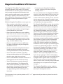
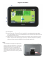
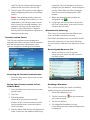
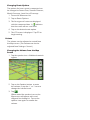
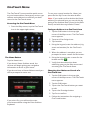
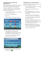
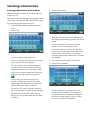
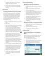
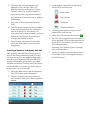
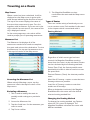
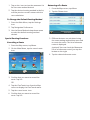
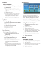
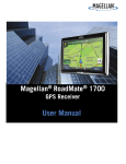
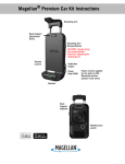
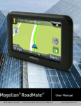
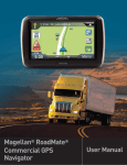
Magellan RoadMate
®
®
User Manual
www.CARiD.com
Magellan RoadMate GPS Receiver
The Magellan® RoadMate® receiver is a vehicle
navigation product that utilizes GPS signals
from satellites to calculate your precise location
and compute navigational information that
can be used to guide you to your destination.
Knowing its position and movement, it can
then overlay this information on detailed maps
to provide a visual representation of your
location.
With the Magellan RoadMate receiver you can:
• Save searches and addresses under the
OneTouch™ menu for fast, convenient
access to favorite destinations and searches.
• Store your home address and quickly get
routing details to your home.
• Enter and save addresses in your address
book that can be accessed at any time and
get routing information to that address.
• Route to an address that you enter using
the QuickSpell™ and Smart City search for
easy, errorless address entry.
• Route to any point of interest (POI) that
has been preloaded into your Magellan
RoadMate receiver.
• Create a route with multiple destinations.
Handy for business people who need
routing information to many destinations.
• Access the AAA TourBook® providing
ratings and descriptions on AAA-approved
places to stay, play, dine, and save.
• Access AAA Member Roadside Assistance™
information from the OneTouch menu.
• View POIs that are near exits ahead of
you on the highway. The Highway Exit
POIs function provides you with a list of
gas stations, restaurants, hotels and auto
repair shops located nearby exits you
are approaching while travelling on the
interstate.
• Customize your Magellan RoadMate
receiver to meet your needs using the
Settings menu.
The user interface for the Magellan RoadMate
receiver is easy and simple to follow once you
understand the basics. You may never need
to refer to this manual, but if you do, we have
tried to present it in a form that makes it easy
for you to access the function you are trying to
use and follow the steps provided.
The Magellan RoadMate receiver has a built-in
battery so, in most cases, you will be able to
follow these instructions while reading them
on your computer screen without plugging
the Magellan RoadMate receiver to the AC
power using an optional AC power adapter.
Note that a fully charged Magellan RoadMate
only has about 2 hours of battery life. You
should note that while indoors you may not
get strong enough satellite signals to compute
your location, so your location information
may not be updated. However, the power
of the GPS chipset installed in the Magellan
RoadMate receiver will pick up satellite signals
in some very demanding locations. You may
find that the Magellan RoadMate receiver is
computing a position, even indoors. Even
with the improved GPS chipset, the receiver
may not be able to always compute a fix
indoors. This is especially important to note
if you are in a garage or other overhanging
structure. If you find you are not getting strong
enough satellite signals while in a garage or
other structure, move to a location where
there is a clear view of the sky and you should
immediately see an improvement in signal
strength.
The Magellan RoadMate receiver includes
Voice Alerts (both prerecorded and Text-toSpeech) for driving instructions.
This document is set up to be printed on 8.5” x 11” paper should you desire a printed version for
your reference.
Magellan RoadMate
A
B
C
(A) Power Switch
(B) micro SD card slot. The microSD card is available for accessing optional map regions.
Check the Magellan store at www.magellangps.com for additional map regions that may
be available for your receiver.
(C) USB Connection. Power input from vehicle power adapter cable or optional AC power
adapter. Also used for connecting your receiver to a personal computer for updating
maps and software using the Magellan Content Manager application.
Reset
The reset button is located on the back of the
receiver in the lower right corner. If you have
problems with your receiver or in the unlikely
event that it locks up, use a paperclip and
gently insert it into the reset hole to press the
reset button with the receiver turned on. The
receiver should restart with the factory defaults
loaded.
Reset
Fundamentals
Powering on the Magellan RoadMate
receiver
The Power On/Off switch is located on the top
of the Magellan RoadMate receiver.
Turning the Magellan RoadMate receiver
On
1. Press the power switch.
2. After the initial splash screen the
Warnings screen is displayed. Read and
.
tap
Turning the Magellan RoadMate receiver
Off
Viewing the Battery Level Indicator
1. While viewing the Map screen, tap on the
Menu button in the right corner.
2. The battery level indicator is located in
the upper right corner of the Main Menu,
just below the satellite signal indicator.
Green bars indicate battery level.
Speaker Volume
Changing the Volume from the Map
Screen
1. Tap the speaker icon . Additional controls
appear.
1. Press the power switch. The receiver will
automatically power off in 15 seconds.
[Cancel] cancels the power off sequence
and returns to last viewed screen.
[Power Down Now] turns the receiver
off immediately, bypassing the 15 second
delay.
Note: Anytime the power cable is
disconnected from the receiver or if power is
turned off at the 12v power receptacle, the
receiver will begin the power off sequence.
Battery Levels
The Magellan RoadMate receiver has an
internal battery that is charging whenever
the receiver is connected to external power.
2. Tap the speaker button to mute the
volume, or tap the ‘+’ or ‘-’ buttons to raise
or lower the volume.
3. Tap
.
Changing the Volume from Settings
1. Access the Main Menu.
2. Tap the Settings icon .
3. Tap Sound.
4. Tap inside the Master volume adjust
bar to change the volume level of the
Magellan RoadMate receiver.
5. Tap
to save and exit.
Setting Button Sounds On or Off
1. Access the Main Menu.
Note: The battery can only be serviced by
authorized Magellan repair facilities.
2. Tap the Settings icon .
3. Tap Sound.
4. Tap the check box for Button Sounds.
Check to have button sounds played,
unchecked to turn them off.
Setting Smart Volume On or Off
Main Menu
The Main Menu screen is the center for all
available functions of the Magellan RoadMate
receiver. The Main Menu contains large, easy
to access icons for all the major functions.
Smart Volume is a feature of the receiver that
changes the volume automatically as your
speed changes, compensating for road noise.
1. Access the Main Menu.
2. Tap the Settings icon .
3. Tap Sound.
4. Tap the check box for Smart Volume.
When checked, Smart Volume is on.
Brightness
Accessing the Brightness Control
1. Access the Main Menu.
2. Tap the Settings icon .
Accessing the Main Menu
1. From the Map screen tap Menu.
Functions Available from the Main Menu
Address
3. Tap System.
4. Tap Brightness.
Points of
Interest
Previous
Intersection
5. Tap inside the brightness adjust bar to set
the desired brightness.
Note: On the Brightness Setting screen there
is a “Dim on Battery Power” option. When
checked, the Magellan RoadMate receiver
will reduce the brightness when operating
exclusively on battery power and you have not
used the touch screen for a few seconds. This
prolongs the battery life between charges.
City Center
Current
Location
Back
Enter an address as
a destination for you
route.
Select a Point of Interest
(POI) from the list of
preloaded locations as
a destination.
List of the most resent
destinations that you
have gone to before
allowing you to quickly
select one to route to
again.
Create a route to the
intersection of two
streets.
Create a route to the
geographical center of
a city.
Displays information
about your position
including the street
name, names of streets
forward and behind
you as well as the Lat/
Long information for
your position.
Access the Map screen.
Address Book
Settings
Satellite Status
Battery Level
Access the Address
Book where you
can save addresses
and destinations to
have available when
needed.
Displays the Settings
menu. This menu can
be used to access
functions used to
customize the Magellan
RoadMate receiver to
your personal needs.
Graphic display of the
strength of satellite
signals being received.
Graphic display of the
current battery level.
Symbols
Displays available
symbols.
Previous
Previous destination
list (Enter City only)
When entering a
city, the previous
destinations list displays
a list of cities previously
entered. Tap on a city
from the displayed list
to accept that city.
(Enter City only)
Displays a numeric
keypad to quickly enter
a city when the zip
code is known.
(Enter City only) While
entering a city, press
the List button to
bring up a list of cities
beginning with the
characters you have
entered.
(Entering City) Accepts
the suggested city that
is displayed in the data
field. (Entering street)
Brings up a list of
streets beginning with
the characters entered.
Zip Code
List
Keypad
The keypad is the most common method for
entering data into the Magellan RoadMate
receiver. Understanding the keypad while
entering an address is an important part of
using your Magellan RoadMate receiver.
Accept
Selecting From List
When a list of items found in the database are
displayed, use the arrows on the right to move
the list up and down and tap on the desired
item in the list to continue.
Selecting QWERTY or ABC Keyboard
1. Access the Main Menu.
Keypad Overview
Backspace
Shift
Space
Numeric
Moves the cursor one
position backwards,
deletes the preceding
character.
Shifts between
uppercase and
lowercase characters.
Inserts a space at the
cursor position.
Displays a numeric
keypad.
2. Tap the Settings icon .
3. Tap Keyboard.
4. Select QWERTY or ABC.
Notes on Entering Data
If you are having trouble getting the results
you expected, here are a few useful tips.
• Check for apostrophes and hyphens. If you
do not see the POI or street name you are
looking for in the list, check to see if the
name has an apostrophe or hyphen.
• The more characters you enter, the smaller
the list of possible options is from which to
choose.
• When entering a street or city name it is
not necessary to use accented letters. You
can enter city and streets names using only
standard characters.
QuickSpell
Another feature the Magellan RoadMate
receiver uses to make entering cities and
streets easier is a feature known as QuickSpell.
As letters are entered for a city or street the
Quickspell feature checks the database for
cities or streets that begin with the letters
entered. Any letters that could not be used to
spell a city or street name are greyed out. This
provides quick and error-free city and street
name entry.
If the city is correct, tap the
continue.
button to
button can be tapped to display
The
the list of cities that begin with the letters
entered.
Smart City Search
The Magellan RoadMate receiver utilizes a
feature known as “Smart City Search”. Smart
City Search attempts to predict the city you are
looking for. This prediction is based upon two
factors; your position and cities you’ve gone to
before.
Whenever entering or searching on an
address the first screen displayed is the Enter
City Name keyboard.
As letters are entered, Quickspell checks the
database for cities beginning with the letters
entered. Keys that don’t spell a city in the
database are greyed out and Smart City Search
displays a suggested city in the text field.
Quickspell and Smart City Search makes
entering an address quick and easy with little
chance for errors.
Map Screen
The most commonly used screen is the Map
screen. Whether you are following a route or
just traveling around a city, the chances are
that the Map screen will be displayed. The Map
screen can be displayed in two unique modes:
normal and routing.
In normal mode, your position is shown on
the map along with the time. As you travel,
your position will be updated, giving you a
clear view of your position and surrounding
streets.
H
G
F
F
E
B
A
B
G
A
In routing mode additional information is
displayed providing detailed information about
the route you have selected.
D
C
(A) Current location.
(B) Information display. Displays speed, time
of day, elevation, compass direction. Tap on
the information field to change.
(C) Zoom Out/In.
(D) Access Main Menu.
(E) Access Highway POIs (displayed only
while on a highway).
(F) Access volume controls.
(G) Access OneTouch Menu. OneTouch Menu
gives you instant access to your saved search
criteria and favorite destinations.
C
E
D
(A) Turn instructions for next maneuver. Tap
to display the maneuver list (available only
when routing). Distance and road name for
the next maneuver. Tap to repeat last voice
instruction.
(B) Speed limit
(C) Information display. Displays speed, time
of day, elevation, compass direction. While
routing it also can also display distance to
destination, estimated time of arrival (ETA),
and time remaining. Tap on the information
field to change.
(D) Zoom in and zoom out controls to change
the map scale.
(E) Access Main Menu.
(F) Access the list of nearest Highway Exit
POIs (available only when driving on a
highway/freeway/interstate).
(H) Access volume controls.
(G) Access OneTouch Menu. OneTouch Menu
gives you instant access to your saved search
criteria and favorite destinations.
Setting the Map Options
How your map is displayed can be customized
in Settings to your preferences.
1. From the Map screen, tap the MENU
button.
Panning on the Map
1. While viewing the Map screen, slide your
finger or a stylus across the map.
2. The map screen changes to Pan mode.
2. Tap the Settings Icon.
3. Tap Map button.
4. Use the Map Options screen to customize
what and how your map is to be
displayed.
3. When finished, tap
and the map
returns to your current position.
Routing to a Panned Position
1. Pan the map until the location you wish
to route to is displayed.
Setting the Map Modes (2D or 3D)
The map is normally displayed in 3D mode
(perspective view) but you can set the map to
2D mode (top down view) if so desired.
2. Tap on the map at the point you want to
go to. A red push pin will be displayed
along with information about the point
chosen at the top of the screen.
1. From the Map screen, tap anywhere on
the map. Additional controls appear.
2. Tap 2D to switch the map to 2D mode
from 3D mode, or tap 3D to switch the
map to 3D mode from 2D mode.
3. Tap
.
Setting Zoom Levels
Select the zoom level that best suits your
needs. Note that zoom levels are limited in 3D
mode. As you zoom out in 3D, the display will
switch to 2D at higher zoom levels.
1. Tap the ‘+’ or ‘-’ zoom level buttons at
the bottom of the Map screen to set the
desired zoom level.
3. Tap the GO button in the top left corner.
4. If an active route already exists, you will
need to define what to do with this new
route point:
Replace Destination: the next destination
is cleared and replaced with the one
selected from the Pan screen.
Go There Now: the selected location is
inserted in the route as an intermediate
destination before the next destination.
Add To Trip: the selected destination is
added to the end of the current trip.
5. Tap the large GO button on the right to
begin navigating and return to the Map
screen.
Note: if the panned position does not
match an existing street address (i.e. the
destination is not along a road or street
that is stored in the map database), the
guidance will stop on the road that is
closest to your destination. A dashed
line to your final destination will then be
displayed on the map.
Current Location Screen
The Current Location screen displays the
approximate address of your current position,
the next and previous intersections, your
latitude, longitude, heading and elevation.
(optional) Tap List Categories to select a
category for this address. New categories
can be added from the Select Category
from List screen by tapping the +Add
button.
5. When the details for this address are
acceptable, tap
.
6. If you have selected to save this point to
the OneTouch menu, you need to select
a button for the entry.
Maneuver List (Itinerary)
This screen is accessed from the Map screen
and is available only when routing.
Each line in the Maneuver List provides details
about the maneuvers in the order that they
are to be made, with the next maneuver at the
top.
Accessing the Maneuver List
1. When actively on a route, tap the
maneuver icon in the top left corner of
the Map screen.
Accessing the Current Location Screen
1. From the Map screen tap on the current
position icon.
Saving Your Current Location to Your
Address Book
1. From the Map screen tap on the current
position icon .
2. Tap Save.
3. Edit information:
(optional) If you want to save this
location to the OneTouch menu as well
as the address book, check the Add to
OneTouch box.
4. Tap the Name field and use the keypad to
enter a name for the Address Book entry.
Avoiding a Maneuver
This is used to modify the route to possibly
avoid routing on a particular street.
1. Access the Maneuver List.
2. Tap the Avoid icon
you want to avoid.
for the maneuver
3. Tap Yes to confirm.
4. The Magellan RoadMate receiver
recalculates the route and the Map screen
is displayed.
Changing Route Options
The options for how a route is computed can
be changed to Fastest Time, Shortest Distance,
Mostly Freeways, Least Use of Freeways.
1. Access the Maneuver List.
2. Tap on Route Options.
3. The four types of routes are displayed
with the computed time. A
indicates
that the route will use a toll road.
4. Tap on the desired route option.
5. The GO screen is displayed. Tap GO to
begin routing.
Volume
The volume can be adjusted or muted from
the Map screen. (The volume can also be
adjusted from Settings > Sound.)
Changing the Volume from the Map
Screen
1. Tap the speaker icon . Additional controls
appear.
2. Tap on the Speaker button to mute
the volume, or tap the ‘+’ or ‘-’ icons to
change the volume levels.
3. Tap
.
When muted the speaker icon on the
Map screen will appear with a red
diagonal line through it. Tap on the
speaker icon again ut unmute the
volume.
OneTouch Menu
The OneTouch™ menu provides quick access
to your home address, emergency services, gas
stations and addresses or searches you have
stored to the OneTouch menu.
Accessing the OneTouch Menu
1. From the Map screen, tap the OneTouch
icon in the upper right corner.
To use your current location for Home, just
press the Use My Current Location button.
Note: If you need to edit or delete the Home
address you selected here you can do this by
going to the Address Book (found in the Main
menu) and edit the entry labeled “Home”.
Saving an Address to a OneTouch Icon
1. Tap the Edit button in the top right
corner of the Map screen. The OneTouch
menu appears.
2. Tap one of the Assign icons.
3. Tap Location.
4. Using the keypad, enter the address (city,
street and number) for the OneTouch
icon.
5. When the address is complete you are
prompted to enter a name for the button.
The Home Button
Tap the Home icon.
If you have a Home Address saved, the
receiver will begin giving you navigation
information to arrive at your home.
If you do not have a Home Address saved you
will be prompted to enter one.
6. Using the keypad, enter a name for the
button and tap
.
7. Verify that the address has been
added by going to the Map screen and
accessing the OneTouch menu.
Changing the Address or Search of a
OneTouch Icon
1. Tap the Edit button in the top right
corner of the Map screen. The OneTouch
menu appears.
2. Tap the Edit button.
3. Tap on the OneTouch button you want
to edit.
4. Tap on the Re-assign button.
5. Tap Yes to confirm.
If you select Yes, you will need to enter
your home address using the Enter Address
keyboard.
6. Follow the instructions for assigning a
OneTouch button.
Saving a POI Search Criteria to a
OneTouch Icon
Besides frequently visited destinations, you can
also save POI search criteria to a OneTouch
button. For example you may frequently
search for coffee shops near your location or
gas stations along your route. You can save
these searches for later use.
1. Tap the OneTouch button in the top right
corner of the Map screen.
2. Tap one of the Assign buttons.
3. Tap Search.
4. Tap one of the POI categories in the list.
Setting a Route to a OneTouch Icon
With the OneTouch menu set up you can now
go to a saved address or search.
1. Tap the OneTouch button in the top right
corner of the Map screen.
2. Tap one of the assigned OneTouch
buttons.
3. If the assigned button is for a search,
the list of POIs is displayed. Tap on the
desired POI.
The “Preview” icon at the bottom of
the display allows you to step through
the available POIs while viewing their
location on the map.
4. The “Near...” button allows you to select
how the list is sorted (nearest your
current position, nearest a city you define
or near an address you enter).
5. Whether the destination was chosen
from a list of POIs or by an address, the
GO screen is displayed Tap on the Go
button to begin the route.
5. If the next screen contains a list of
subcategories, tap one of the POI
subcategories in the list to further narrow
the search, or tap “All Subcategories” to
select all the subcategories or continue
defining your search criteria.
6. Using the keypad, enter a name for the
.
button and tap
Selecting a Destination
Creating a Destination to an Address
3. Enter Street name:
When creating an address, the first step is to
enter the city.
The city can be specified by entering the name
of the city, entering the ZIP code for the city or
by selecting a previously used city.
1. From the Main Menu tap the Address
icon.
2. Enter City:
With the city selected, the keyboard will
be displayed prompting you for the street
name.
You have three ways to do this:
To select the city from the list of previous
cities, tap the Previous button.
To enter a new city: use the keyboard
to enter the first few characters of any
significant word in the city name. If the
city you are entering appears in the top
field you can tap on the city name or
.
Use the keyboard to enter the street
name. It is not necessary to enter
accented characters. Enter the first few
characters of any significant word in the
street name and tap the or continue
entering characters until the list of streets
is displayed.
4. Tap on the street name from the list.
5. Enter Street number:
At any time you can tap on the List
button to bring up a list of cities that
begin with the characters you entered.
Tap to select the city from the list.
To enter a ZIP code: if needed, tap the
Zip Code button to switch to the numeric
keyboard. Enter the ZIP code. Tap to
bring up a list of cities with the zip code
entered.
Use the keyboard to enter the street
number for the address. The range of
acceptable street numbers is displayed
before you start typing. Tap the when
the street number is complete.
6. The GO screen appears with the address
of the selected location, the estimated
time of arrival (ETA), the distance to
travel, and the routing method (e.g.
Fastest Time).
Intersections
Creating a Destination to an Intersection
When the street number is not known, an
intersecting street can pinpoint the location.
1. From the Main Menu, tap the Intersection
icon.
2. Enter City:
You have three ways to do this:
To select the city from the list of previous
cities, tap the Previous button.
(optional) Tap Options if you want to
change the routing method.
(optional) Tap on to preview the route.
7. Tap the large GO button on the right
to return to the Map screen and begin
routing.
Tip: If you know that you will use a
destination later, before tapping the
orange button you can tap Save to save it
in your Address Book or in the OneTouch
menu.
Tips on Entering Addresses Quickly
• When you are entering the name of a city
or a street, Magellan software only displays
those characters that appear in possible
search results. The other characters are
grayed out.
• When entering city names or street names,
tap the List button after a couple of letters;
Magellan software lists the items that
contain the specified characters.
• You can also search by ZIP codes. This
narrows the number of matching cities to
normally less then four.
To enter a new city: use the keyboard
to enter the first few characters of any
significant word in the city name. If the
city you are entering appears in the top
.
field you can tap on the city name or
At any time you can tap on the List
button to bring up a list of cities that
begin with the characters you entered.
Tap to select the city from the list.
To enter a ZIP code: if needed, tap the
Zip Code button to switch to the numeric
keyboard. Enter the ZIP code. Tap to
bring up a list of cities with the zip code
entered.
3. Enter Street name:
With the city selected, the keyboard will
be displayed prompting you for the street
name.
Use the keyboard to enter the street
name. It is not necessary to enter
accented characters. Enter the first few
characters of any significant word in the
street name and tap the or continue
entering characters until the list of streets
is displayed.
Tap on the street name from the list.
4. Enter the second street:
Enter the name of the second street as
you did the first street.
5. A screen appears with the address of the
selected location, the estimated time of
arrival (ETA), the distance to travel, and
the routing method (e.g. Fastest Time).
(optional) Tap Options if you want to
change the routing method.
6. Tap the large GO button on the right
to return to the Map screen and begin
routing.
City Centers
Creating a Destination to a City Center
City Center allows you to select any city on
the map as your destination. This option is
particularly useful when you want to go to
a city without having any specific address
to select. (A route to a city center uses
the geographical center of the city as the
destination point.)
1. From the Main Menu, tap the City Center
icon.
2. Enter City:
To select the city from the list of previous
cities, tap the Previous button.
To enter a new city: use the keyboard
to enter the first few characters of any
significant word in the city name. If the
city you are entering appears in the top
.
field you can tap on the city name or
At any time you can tap on the List
button to bring up a list of cities that
begin with the characters you entered.
Tap to select the city from the list.
To enter a ZIP code: if needed, tap the
Zip Code button to switch to the numeric
keyboard. Enter the ZIP code. Tap to
bring up a list of cities with the zip code
entered.
3. A screen appears with the address of the
selected location, the estimated time of
arrival (ETA), the distance to travel, and
the routing method (e.g. Fastest Time).
(optional) Tap Options if you want to
change the routing method.
4. Tap the large GO button on the right
to return to the Map screen and start
navigating.
Previous Destinations
Routing to a Previous Destination
1. From the Main Menu, tap the Previous
icon.
2. Select the destination from the list of
previous destinations.
3. A screen appears with the address of the
selected location, the estimated time of
arrival (ETA), the distance to travel, and
the routing method (e.g. Fastest).
(optional) Tap Options if you want to
change the routing method.
4. Tap the large GO button on the right
to return to the Map screen and start
navigating.
Clearing the list of Previous Destinations
1. Access the list of Previous Destinations as
described above.
2. Tap Delete All to clear the list.
3. To confirm the deletion, tap Yes.
Address Book
Saving a Destination to Your Address
Book
Whenever you create a destination you can
save the destination to your address book
before beginning the route.
1. On the Go screen, tap Save.
2. The Edit Information screen is displayed.
If you want to save this location to
the OneTouch menu, select Add to
OneTouch.
Edit information:
Tap the Name field and use the keyboard
to enter a name for the address book
entry.
(optional) Tap <Work, Cell or Home
phone> to specify a phone number for
the address book entry.
(optional) Tap List Categories to bring up
a list of categories you have created for
your address book. If the category you
want isn’t there, you can create one by
tapping the “+ Add” button at the bottom
of the screen.
3. When the details for this address are
.
acceptable, tap
4. If you have selected to save this to the
OneTouch menu, you be asked to select
a the OneTouch button you want it
assigned too.
Accessing an Address in Your Address
Book
1. From the Main Menu, tap the Address
Book icon.
2. To easily find the desired address you can
tap the top left corner of the screen and
narrow the list by the first letter of the
address book entries.
Routing to an Address in Your Address
Book
1. Access the address record from your
address book as described above.
2. Tap the GO icon of the desired address
book entry. A screen appears with
the address of the selected location,
the estimated time of arrival (ETA),
the distance to travel, and the routing
method (e.g. Fast).
3. (optional) Tap Options if you want to
change the routing method.
4. Tap the large GO button on the right
to return to the Map screen and start
navigating.
Points of Interest (POI)
The Magellan RoadMate receiver has
preloaded POIs that can be used as a
destination for a route. Selecting a restaurant
or finding a gas station nearby is at your
fingertips.
4. POIs near your current position are
displayed. You can tap “Near...” for
different search criteria (Near Current
Position, Near City, or Near Address).
Creating a Route to a POI by Category
POIs are categorized into unique categories
from gas stations to tourist attractions. Most,
but not all categories are further organized
into subcategories. Restaurants have, for
example, several subcategories that provide a
way to search for restaurants serving Chinese
food, fast food, or other favorites.
1. From the Main Menu, tap the Points of
Interest icon.
2. Tap one of the POI categories in the list.
If you select Near City or Near Address
you will need to enter the city or address
information.
5. Select the POI desired from the list of
POIs.
6. The ‘Go’ screen appears with the address
of the selected location, the estimated
time of arrival (ETA), the distance to
travel, and the routing method (e.g.
Fastest Time).
3. If the next screen contains a list of
subcategories, tap one of the POI
subcategories in the list to further narrow
the search.
(optional) Tap Options if you want
to change the routing method. You
can select from Fastest Time, Shortest
Distance, Mostly Freeways or Least Use of
Freeways.
7. Tap the large Go button on the right
to return to the Map screen and begin
navigating to the POI selected.
Creating a Route to a POI by Name
1. From the Main Menu, tap the Points of
Interest icon.
2. Tap the Search By Name button.
3. Spell the name of the POI to be used as
the destination. You don’t need to enter
the full name, but the more characters
you enter, the easier it will be to find the
.
exact POI you are searching for. Tap
4. POIs near your current position are
displayed. You can tap “Near” for
different search criteria (Near Current
Position, Near City, or Near Address).
If you select Near City or Near Address
you will need to enter the city or address
information.
3. Small symbols represent the following
service POIs near the exits:
Restaurants
Gas Stations
5. Select the POI desired from the list of
POIs.
Car Repair
6. The ‘Go’ screen appears with the address
of the selected location, the estimated
time of arrival (ETA), the distance to
travel, and the routing method (e.g. Fast).
Accommodations
(optional) Tap Options if you want to
change the routing method.
7. Tap the large Go button on the right
to return to the Map screen and start
navigating.
Creating a Route to a Highway Exit POI
The Highway Exit POIs function provides a
way of accessing commonly used POIs that
are near an exit you are approaching while
travelling on a highway. Highway Exit POIs
include restaurants, gas stations, car repair
facilities and hotels. Freeway Exit POIs can be
accessed while on a route or just driving, as
long as you are on a freeway.
1. From the Map screen, tap the Highway
Exit POIs button when it appears.
2. The list of the next freeway exits and
their distance from your current position
appear.
4. Tap any of the symbols to get a list of
related POIs near the exit.
5. Select one POI from the list, and tap
.
6. The ‘Go’ screen appears with the address
of the selected POI, the estimated time of
arrival (ETA), the distance to travel, and
the routing method.
(optional) Tap Options if you to change
the routing method.
7. Tap the Go button on the right to return
to the Map screen and begin routing to
the POI selected.
Traveling on a Route
Map Screen
When a route has been calculated, it will be
displayed on the Map screen in green with
small arrows indicating the direction of travel.
The top of the screen displays the name of
the street that comes next in your Turn List
together with its distance. If you are not in the
city in which the next street is, the name of the
city is displayed instead.
5. The Magellan RoadMate receiver
recalculates the route and the Map screen
returns.
Types of Routes
There are a wide variety of methods you can
use to create a route. Each method is discussed
in the chapter which is associated with it.
Routing Method
As the route progresses, voice alerts will be
used to prompt you of upcoming maneuvers.
Maneuver List
The Maneuver List displays all of the
maneuvers needed to be made to complete
the route and arrive at the destination. To view
the Maneuver List, tap on the maneuver icon
in the top left corner of the Map screen.
Regardless of which route type has been
created, the Magellan RoadMate needs to
know how the route is to be calculated. Routes
can be calculated by the following methods:
Fastest Time (Fast): the fastest possible route
provided the vehicle is able to travel at or near
the speed limit.
Shortest Distance (Short): the shortest possible
route.
Accessing the Maneuver List
When actively following a route, tap the
maneuver icon in the top left corner of the
Map screen.
Excluding a Maneuver
1. This is used to modify the route to
possibly avoid routing on a particular
street.
2. Access the Maneuver List.
3. Tap the Avoid icon for the maneuver you
want to avoid.
4. Tap Yes to confirm.
Most Use of Freeway: creates a route that uses
freeways whenever possible.
Least Use of Freeway: creates a route that
avoids use of freeways.
When a destination is selected, the Magellan
RoadMate offers the route with the default
selected routing method first.
Changing the Routing Method
To change the routing method, tap Options
when the ‘Go’ screen is displayed. The
Magellan RoadMate calculates the route with
different methods.
1. Tap on the icon to view the maneuver list
for the route method desired.
2. Tap the desired routing method in the list,
and the previous screen returns with the
new calculation.
Detouring off a Route
1. From the Map screen, tap Menu.
2. Tap the Detour icon.
To Change the Default Routing Method
1. From the Main Menu, tap the Settings
icon.
2. Tap Navigation Preferences.
3. Use the Route Method drop-down menu
to select the default routing method
desired.
Special Routing Functions
Cancelling a Route
1. From the Map screen, tap Menu.
2. On the Main Menu, tap the cancel route
icon.
3. Different detours are calculated using
the same routing method that was used
to create the route. The list of alternate
routes is displayed.
(optional) You can check the Maneuver
List of an alternate route if you tap the
button on the right.
4. Tap the desired alternate route.
3. Confirm that you want to cancel the
route. Tap Yes.
OR
4. Tap the OneTouch icon from the Map
screen to display the OneTouch menu.
5. Tap the cancel route icon.
6. Confirm that you want to cancel the
route. Tap Yes.
Settings
With user Settings you can customize the
Magellan RoadMate receiver to better suit your
personal needs and preferences.
Note: Tapping the Back arrow Tap from any
of the Setting screens saves your changes.
Accessing System Settings
From the Main Menu screen, tap the Settings
icon.
3. Tap Night Mode to select Automatic for
the timed adjustment, on always or off
always.
Setting Heading Up or North Up in 2D
Mode
1. From the Main Menu screen, tap the
Settings icon.
2. Tap Map.
3. Tap 3D, 2D Heading Up or 2D North Up
to toggle between settings.
Assigning Visible POIs
To avoid cluttering of the map, the POI icons
that are displayed on the map can be turned
on or off.
1. From the Main Menu screen, tap Settings.
2. Tap Map.
3. Tap POI Visibility.
Map Options
4. Use the POI Selection screen to check
those POIs you want shown and uncheck
those you want hidden.
Setting Auto Zoom on Turns
You can set the map to automatically zoom in
to the lowest level when coming up to a turn.
1. From the Main Menu screen, tap the
Settings icon.
2. Tap Map.
3. Checking Auto Zoom on Turns enables
this function.
Setting Auto Night Map Display
Normally the map is displayed in vivid colors
for daytime use and with dark tints for night
use. You can select whether to always use
daytime colors, night color or let the Magellan
RoadMate receiver switch between them
automatically a few minutes before sunrise
and a few minutes after sunset.
1. From the Main Menu screen, tap the
Settings icon.
2. Tap Map.
Setting Highway Lane Assist
When Highway Lane Assist is checked,
the map will display highway signs as you
approach a highway interchange giving you
visual indication of which lane you want to be
in.
1. From the Main Menu screen, tap the
Settings icon.
2. Tap Map.
3. Checking Highway Lane Assist enables
this function.
Sound
Setting Volume from Settings
1. From the Main Menu screen, tap the
Settings icon.
2. Tap Sound.
3. Tap inside the volume slider bar to set the
desired volume level.
Turning Button Sounds On/Off
1. From the Main Menu screen, tap the
Settings icon.
2. Tap Sound.
3. Unchecking Button Sounds will turn off
the audible indication that a button is
tapped.
Turning Smart Volume On/Off
Smart Volume adjusts the sound levels based
on vehicle speed which normally increases
road noise making the speaker harder to hear.
1. From the Main Menu screen, tap the
Settings icon.
2. Tap Sound.
3. Unchecking Smart Volume turns Smart
Volume off.
Navigation
Setting The Turn Warning Alert Sounds
1. From the Main Menu screen, tap the
Settings icon.
2. Tap Navigation Preferences.
3. Use the drop-down menu to select the
default sound you want played when
alerting you to a turn.
Enabling Landmark Guidance
Landmark Guidance uses common landmarks
when available to help you identify streets
requiring a maneuver.
1. From the Main Menu screen, tap the
Settings icon.
2. Tap Navigation Preferences.
3. Checking Enable Landmark Guidance
turns Landmark Guidance on.
Enabling Spoken Street Names
1. From the Main Menu screen, tap the
Settings icon.
2. Tap Navigation Preferences.
3. Checking Enable Spoken Street Names
allows street names to be spoken while
giving guidance.
Enabling U Turn Guidance
1. From the Main Menu screen, tap the
Settings icon.
2. Tap Navigation Preferences.
3. Checking Enable U Turns will allow the
receiver to use U turns when necessary to
compute your route.
Avoiding Toll Roads
1. From the Main Menu screen, tap the
Settings icon.
2. Tap Navigation Preferences.
Setting The Default Route Method
1. From the Main Menu screen, tap the
Settings icon.
2. Tap Navigation Preferences.
3. Use the drop-down menu to select the
default routing method.
3. Checking Avoid Toll Roads tells the
receiver to avoid toll roads whenever
possible.
Brightness
Phantom Alerts
Setting Brightness
1. Access the System Settings menu (above).
2. Tap Brightness.
3. Tap in the brightness slider to set the
brightness of the display for either day or
night use.
4. Tap the back arrow .
5. The Dim on Battery Power option will
prolong battery life by dimming the
display while using internal battery
power. Check to turn this option on.
Languages
Setting Languages
1. Access the System Settings menu (above).
2. Tap Languages.
Phantom Alerts provide information on
information that might affect the route you
are on. There are Standard Alerts that are
included in the Magellan Roadmate and
Premium Alerts that are greyed out until they
have been purchased from the Magellan Store.
Setting Phantom Alert Options
3. Tap on the desired language.
1. From the Main Menu screen, tap the
Settings icon.
4. Confirm the change.
2. Tap Phantom Alerts.
5. Tap the back arrow.
3. Tap on the alert to be set.
Speed Warnings
Setting Speed Warning Options
1. From the Main Menu screen, tap the
Settings icon.
2. Tap Speed Warning.
3. Set Audible Warning on or off.
4. Set Visible Warning on or off.
5. The Visible checkbox determines if the
speed limit icon is displayed on the
screen.
6. Set the number of miles above the speed
limit you want the warnings to be alerted
or highways and other roads.
4. There are three options for phantom
alerts that can be turned on or off; audio
alert, visual alert, and show on map.
5. When an option is checked it is turned
on.
6. Tap the back arrow.
Time Zone
Selecting the Time Zone
1. Access the System Settings menu (above).
2. Tap Time Zone.
3. Check Auto Time Zone or select your time
zone from one of the cities in the list.
4. Tap the back arrow.
Time Format
Setting the Time Format
1. Access the System Settings menu (above).
2. Tap Time Format.
3. Tap on 24 Hours or 12 hours with am/
pm.
4. Tap the back arrow.
Keyboard
Setting the Keyboard Layout.
1. From the Main Menu screen, tap the
Settings icon.
2. Tap Keyboard.
3. Select QWERTY (default) or ABC keyboard
layouts.
Units of Measure
Selecting Units of Measure
1. Access the System Settings menu (above).
2. Tap Units.
1. From the Main Menu screen, tap the
Settings icon.
2. Tap GPS Options.
3. Tap Set GPS Position.
4. Enter an address as you were selecting a
destination.
Viewing the GPS Status
1. From the Main Menu screen, tap the
Settings icon.
2. Tap GPS.
3. Tap Status.
4. (Optionally you can tap on the satellite
signal indicator in the upper right corner
of the OneTouch screen to access the
GPS Status screen.)
Auto Power Off
Setting Auto Power Off
Auto power is the duration of time that the
Magellan RoadMate receiver remains idle
before turning off automatically.
3. Tap on the desired unit of measure.
1. Access the System Settings menu (above).
4. Tap the back arrow.
2. Tap Auto-Off.
Regions
1. From the Main Menu screen, tap the
Settings icon.
2. Tap Region.
3. Select an available map that is installed in
your receiver.
GPS
Setting the GPS Position
3. Tap on the desired duration.
4. Tap the back arrow.
Default System Settings
Restoring All Default System Settings
1. Access the System Settings menu (above).
2. Tap Restore Default.
3. Confirm that you want to proceed in
restoring all the system defaults.
It is useful to set a GPS position if you are not
Product Information
receiving satellite information quickly due
to travelling over 800 km/500 mi with the
Viewing Product Information
Magellan RoadMate receiver turned off. Setting
1. From the Main Menu screen, tap the
the GPS position will allow the Magellan
Settings icon.
RoadMate receiver to compute which satellites
2. Tap Product Information.
are available and calculate the position more
3. (Note: Scroll down the page to view the
quickly.
Serial Number and Software Version.)
MAGELAN GPS
GPS SYSTEMS