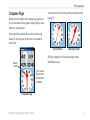
1
Owner’s Manual Astro ™ GPS-enabled dog tracking system © 2008 Garmin Ltd. or its subsidiaries Garmin International, Inc. 1200 East 151st Street, Olathe, Kansas 66062, USA Tel. (913) 397.8200 or (800) 800.1020 Fax (913) 397.8282 Garmin (Europe) Ltd. Liberty House Hounsdown Business Park, Southampton, Hampshire, SO40 9RB UK Tel. +44 (0) 870.8501241 (outside the UK) 0808 2380000 (within the UK) Fax +44 (0) 870.8501251 Garmin Corporation No. 68, Jangshu 2nd Road, Shijr, Taipei County, Taiwan Tel. 886/2.2642.9199 Fax 886/2.2642.9099 All rights reserved. Except as expressly provided herein, no part of this manual may be reproduced, copied, transmitted, disseminated, downloaded or stored in any storage medium, for any purpose without the express prior written consent of Garmin. Garmin hereby grants permission to download a single copy of this manual onto a hard drive or other electronic storage medium to be viewed and to print one copy of this manual or of any revision hereto, provided that such electronic or printed copy of this manual must contain the complete text of this copyright notice and provided further that any unauthorized commercial distribution of this manual or any revision hereto is strictly prohibited. Information in this document is subject to change without notice. Garmin reserves the right to change or improve its products and to make changes in the content without obligation to notify any person or organization of such changes or improvements. Visit the Garmin Web site (www.garmin.com) for current updates and supplemental information concerning the use and operation of this and other Garmin products. Garmin®, AutoLocate®, TracBack®, BlueChart®, MotionBased® and MapSource® are registered trademarks and Astro™ is a trademark of Garmin Ltd. or its subsidiaries and may not be used without the express permission of Garmin. This product includes technology owned by SiRF Technology, Inc. SiRF’s technology is protected by U.S. and foreign patents pending and issued. SiRF, SiRFstar and the SiRF logo are registered trademarks of SiRF Technology, Inc. SiRFstarIII and SiRF Powered are trademarks of SiRF Technology, Inc. microSD™ is a trademark of The SD Card Association. TransFlash™ is a trademark of SanDisk Corporation. Other trademarks and trade names are those of their respective owners. February 2008 Part Number 190-00714-00 Rev. C Printed in Taiwan Introduction Introduction Thank you for choosing the Garmin® Astro™ Dog Tracking System. The Astro 220 uses the proven performance of Garmin GPS and full-featured mapping to create an unsurpassed portable GPS receiver and, when combined with the DC 20, an accurate and reliable dog tracking system. Contact Garmin Contact Garmin if you have any questions while using your Astro 220. In the USA contact Garmin Product Support by phone: (913) 397-8200 or (800) 800-1020, or go to www.garmin.com/support/. Tip and Shortcuts • To quickly return to the Main Menu from any page, press the MENU key twice or press the BACK key repeatedly. • To extend battery life, turn off the GPS when not using the Astro 220 for navigation or dog tracking. Also, decrease the level of the display’s backlight, by quickly pressing and releasing the POWER key. • To extend the battery life of a DC 20, turn the unit off when not tracking a dog, or decrease the update rate. Astro Dog Tracking System Owner’s Manual Introduction Table of Contents Introduction.............................................................. i Contact Garmin.............................................................i Warning.......................................................................iv DC 20 Battery Warnings...............................................v Important Information..................................................vi myGarmin....................................................................vi Getting Started........................................................ 1 Unit Overview.............................................................. 1 Installing the Batteries................................................. 2 Using the Astro 220 Keypad Functions....................... 3 Turning on the Astro 220............................................. 4 Charging the DC 20..................................................... 5 Initializing the GPS Receivers..................................... 5 Calibrating the Astro 220 Compass............................. 6 Operating the Astro 220.............................................. 7 Dog Tracking........................................................... 9 Communicating with the DC 20................................... 9 Tracking a Dog...........................................................11 Tips for Successful Tracking...................................... 14 ii Main Menu............................................................. 15 Start New Hunt.......................................................... 15 Go To Marked Location............................................. 16 View Sunrise/Sunset................................................. 16 View Hunting Almanac.............................................. 16 Advanced.................................................................. 17 Mark Location....................................................... 17 Marking Your Current Location.................................. 17 Marking Hunting Specific Locations.......................... 18 Marking a Location Using the Map............................ 18 Averaging a Marked Location.................................... 19 Projecting a Location................................................. 19 Map Page............................................................... 20 Map Page Options..................................................... 21 Data Fields................................................................ 22 Measuring Distance................................................... 23 Find Features........................................................ 24 Find By Name............................................................ 24 Recent Finds............................................................. 25 Finding a Location..................................................... 27 Finding a Geocache.................................................. 27 Finding a City............................................................ 28 Astro Dog Tracking System Owner’s Manual Introduction Finding an Interstate Exit........................................... 28 Finding an Address.................................................... 28 Intersections.............................................................. 29 Searching for a Point of Interest................................ 29 GPS Applications................................................. 30 Trip Computer Page.................................................. 30 Compass Page.......................................................... 31 Altimeter Page........................................................... 35 Using Tracks.............................................................. 40 Routes....................................................................... 45 Navigating a Route.................................................... 45 Proximity Locations................................................... 49 Satellite Page............................................................ 50 Accessories.......................................................... 52 Calendar.................................................................... 52 Calculator.................................................................. 52 Stopwatch.................................................................. 53 View Sunrise/Sunset................................................. 53 View Hunting Almanac.............................................. 53 Games Menu............................................................. 53 Settings................................................................. 54 System Setup............................................................ 54 Astro Dog Tracking System Owner’s Manual Dog List Setup........................................................... 54 Dog Alerts Setup....................................................... 55 Display Setup............................................................ 55 Tones Setup.............................................................. 55 Main Menu Setup ..................................................... 56 Map Page Setup........................................................ 56 Routing Setup............................................................ 59 Geocache Setup........................................................ 60 Marine Alarms Setup................................................. 61 Time Setup................................................................ 61 Units Setup................................................................ 61 Heading Setup........................................................... 62 Calibration Setup....................................................... 62 Altimeter Setup.......................................................... 63 Appendix............................................................... 64 Specifications............................................................ 64 Optional Accessories................................................. 65 Caring for the Astro System...................................... 71 Software License Agreement.................................... 72 Product Registration.................................................. 72 FCC Compliance....................................................... 73 Limited Warranty....................................................... 75 iii Introduction Warning Failure to avoid the following potentially hazardous situations could result in an accident or collision resulting in death or serious injury. • When installing the unit in a vehicle, place the unit securely so that it does not obstruct the driver’s view of the road or interfere with vehicle operating controls, such as the steering wheel, foot pedals, or transmission levers. Do not place in front of or above any airbag. (See diagram). Do not mount where driver’s field of vision is blocked. Do not place unsecured on the vehicle dashboard. Do not mount in front of an airbag field of deployment. • When navigating, carefully compare information displayed on the unit to all available navigation sources, including information from street signs, visual sightings, and maps. For safety, always resolve any discrepancies or questions before continuing navigation and defer to posted road signs. • Always operate the vehicle in a safe manner. Do Not become distracted by the unit while driving, and always be fully aware of all driving conditions. Minimize the amount of time spent viewing the unit’s screen while driving and use voice prompts when possible. Do not input destinations, change settings, or access any functions requiring prolonged use of the unit’s controls while driving. Pull over in a safe and legal manner before attempting such operations. • This unit is designed to provide route suggestions. It is not designed to replace the need for driver attentiveness regarding road closures or road conditions, traffic congestion, weather conditions, or other factors that may affect safety while driving. WARNING: This product, its packaging, and its components contain chemicals known to the State of California to cause cancer, birth defects, or reproductive harm. This Notice is provided in accordance with California’s Proposition 65. See www.garmin.com/prop65 for more information. iv Astro Dog Tracking System Owner’s Manual Introduction NOTICE REGARDING LEGAL RESTRICTIONS; SPECIAL NOTICE TO USERS IN CALIFORNIA AND ALASKA: State law in California prohibits the use of GPS dog collars for the pursuit of mammals. Alaska law prohibits guides from using GPS devices to assist in the taking of big game animals. This is not intended to be an exhaustive list of applicable laws and ordinances, and Garmin makes no such guarantees or warranties that this list is complete. Check your state and local laws and ordinances to ensure you fully understand any restrictions applicable to this product in your jurisdiction prior to purchase and/or use. Garmin does not assume any responsibility for any fines, penalties, or damages that may be incurred as a result of any state or local law or ordinance relating to use of the product. DC 20 Battery Warnings If these guidelines are not followed, the internal lithium-ion battery may experience a shortened life span or may present a risk of damage to the DC 20, fire, chemical burn, electrolyte leak, and/or injury. • Contact your local waste department to properly dispose of the unit/battery. • Do not leave the unit exposed to a heat source or in a high temperature location, such as in the sun in an unattended vehicle on a hot day. To prevent damage, remove the unit from the vehicle or store it out of direct sunlight, such as in the glove box. • Do not incinerate. • When storing the unit for a limited length of time, store within the following temperature range: -4˚ to 140˚F (-20˚ to 40˚C). When storing the unit for an extended time, store within the following temperature range: 32˚ to 77˚F (0˚ to 25˚C). • Do not operate the unit outside of the following temperature range: -4˚ to 140˚F (-20˚ to 60˚C). • Recharge the unit within the following temperature range: 32˚ to 113˚F (0˚ to 45˚C). The DC 20 unit contains a replaceable, rechargeable lithium-ion battery, the following warnings also apply: • Do not recharge the battery outside of the unit or disassemble the battery. • Keep the used battery away from children. Do not disassemble, puncture, or damage the battery. • Only replace with a Garmin lithium-ion battery pack. Using another battery presents a risk of fire or explosion. To purchase a replacement battery, see your Garmin dealer or the Garmin Web site. • Do not leave the DC 20 where a dog may attempt to chew on it. If the battery cell is punctured, electrolyte can be released that can be harmful to the dog. Astro Dog Tracking System Owner’s Manual Introduction Important Information Map DATA INFORMATION: One of the goals of Garmin is to provide customers with the most complete and accurate cartography that is available to us at a reasonable cost. We use a combination of governmental and private data sources, which we identify in product literature and copyright messages displayed to the consumer. Virtually all data sources contain some inaccurate or incomplete data. In some countries, complete and accurate map information is either not available or is prohibitively expensive. NOTICE REGARDING WINDSHIELD MOUNTING; SPECIAL NOTICE TO DRIVERS IN CALIFORNIA AND MINNESOTA: State law prohibits drivers in California and Minnesota from using suction mounts on their windshields while operating motor vehicles. Check your state and local laws and ordinances for similar restrictions. Other Garmin dashboard or friction mounting options should be used. Garmin does not take any responsibility for any fines, penalties, or damages that may be incurred as a result of disregarding this notice or as a result of any other state or local law or ordinance relating to use of the unit. (See California Vehicle Code Section 26708(a); Minnesota Statutes 2005, Section 169.71.) myGarmin Go to http://my.garmin.com to access the latest services for your Garmin products. From the myGarmin Web site, you can do the following: • Register your Garmin unit. • Subscribe to online services for Points of Interest (POIs) and other useful items. • Unlock optional maps. • Access MotionBased® Web-based activity tracker where you can view your saved tracks on several types of maps. • Download geocaches to your unit. The California Electronic Waste Recycling Act of 2003 requires the recycling of certain electronics. For more information on the applicability to this product, see www.erecycle.com. vi Astro Dog Tracking System Owner’s Manual Getting Started Getting Started Unit Overview VHF antenna Power key LCD screen GPS antenna USB connector port (under weather cap) Lanyard attachment slot Belt clip button attachment location Battery compartment locking D-Ring Battery compartment cover and access to the microSD card tray Keypad Astro Dog Tracking System Owner’s Manual Getting Started Installing the Batteries The Astro 220 operates on two AA batteries (not included), which are located in the back of the unit. You can use Alkaline or NiMH batteries. See page 54 for information on setting the battery type. To install the batteries: 1. Remove the battery by turning the D-Ring 1/4 turn counter-clockwise and pulling the cover loose. 2. Insert the batteries, observing the proper polarity. A polarity diagram is molded into the battery compartment. 3. Reinstall the battery cover. Belt clip button installation (tighten the button securely) Wrist strap installation Battery compartment Remove the batteries from your Astro 220 when you do not expect to use the unit for several months. Data is not lost when batteries are removed. To install the lanyard: 1. Place the loop of the lanyard through the slot at the upper left side on the back of the unit. 2. Route the strap through the loop and pull tight. Belt clip Refer to page 67 for information on accessing the microSD data card in the battery compartment. Astro Dog Tracking System Owner’s Manual Getting Started Using the Astro 220 Keypad Functions POWER Key - Press and hold to turn the unit on or off. Press and release to adjust the backlighting. IN/OUT Zoom Keys - Press to zoom in or out on the Map page. Press to scroll up or down a list on any other page. DOG Key - Press and release at any time to view the Dog Tracker page. MARK Key - Press and release at any time to mark a variety of locations. BACK Key - Press and release to cancel data entry or move backwards through the pages to the Main Menu. Astro Dog Tracking System Owner’s Manual ROCKER Key - Press up, down, left, or right to highlight options and to enter data, or move the map panning arrow. Map Key - Press and release to view the Map page. MENU Key - Press and release to view page options. Press twice to view the Main Menu. ENT (ENTER) Key - Press and release to enter highlighted options, select data or confirm on‑screen messages. Getting Started Turning on the Astro 220 Adjusting the Astro 220 Backlight To turn the Astro 220 on and off: 1. Press and hold the POWER key, a tone sounds and the Introduction page appears, followed by the Dog Tracker page. 2. To turn off, press and hold the POWER key again. To adjust the backlight level: 1. Press and quickly release the POWER key. 2. Press the POWER key repeatedly to cycle through the brightness levels or use the ROCKER up/down arrows. 3. Press ENTER or BACK to close the backlight adjustment window. The first time you turn on the Astro 220, a message appears followed by a prompt. Thereafter, when the Astro 220 is turned on, the Introduction page appears, followed by the Dog Tracker page. You may want to adjust the backlight to see the display better. Backlight Adjustment Slider Introduction Page Dog Tracker Page See page 55 for information on changing the display colors and backlight time out. Astro Dog Tracking System Owner’s Manual Getting Started Charging the DC 20 Every DC 20 is partially charged before leaving the factory, so you don’t need to charge before using it. However, it is recommended that you fully charge the DC 20 before using it on a hunt. To charge the DC 20: 1. Connect the charging assembly to an appropriate electrical source. 2. Slide the slotted spade connector into the matching slot beneath the power switch. 3. Charge until the blue LED on the top of the unit turns off. Note: Charging a fully depleted DC 20 battery requires 3-1/2 to 4 hours. To turn the DC 20 on and off: 1. Press and hold the POWER key. When the unit turns on, the LED turns red and blinks at a steady pulse. 2. To turn off, press and hold the POWER key. Astro Dog Tracking System Owner’s Manual LED blinks red when power is on. DC 20 power key Battery charging slot Initializing the GPS Receivers The first time you turn on your Astro 220 and DC 20, each GPS receiver must collect overhead satellite signal data to establish its current location. To ensure proper initialization, the Astro 220 and DC 20 are shipped from the factory in AutoLocate® mode, which allows each receiver to “find itself” anywhere on Earth whenever you turn it on. To receive satellite signals, both units must be outdoors and have a clear view of the sky. Getting Started To initialize your Astro 220 and DC 20: Hold the units in front of you with the antennas held upward. While the Astro 220 GPS receiver is searching for the satellite signals, observe the GPS Signal Strength bars in the Status Bar at the top of the page. When the receiver has signals from at least three satellites, the GPS bars fill to indicate signal strength and a location fix, while the LED on the DC 20 double blinks at each pulse when a location fix is achieved. Calibrating the Astro 220 Compass It is recommended that the Astro 220 compass be calibrated the first time you use it, after periods of storage, after you install new batteries, or when exposed to temperature changes of greater that 20°F. Calibrate the electronic compass outdoors. The accuracy of the electronic compass is adversely affected if the unit is not held level or you are near objects that generate magnetic fields, such as cars or buildings. Hold the unit level and turn slowly. To calibrate the electronic compass: 1. From the Dog Tracker page or Compass page, press MENU to open the options menu. 2. Select Calibrate Compass to open the Calibration page. 3. Select Start and follow on-screen directions for holding and turning the unit. • A “Just Right,” “Too Fast,” or “Too Slow” message appears notifying you to adjust your turning speed, as needed. Hold the unit level while turning. • A “Calibration Successful” message appears when finished. Press ENTER to exit. • If a “Calibration Failed” message appears, repeat the process. Astro Dog Tracking System Owner’s Manual Getting Started Operating the Astro 220 on the ROCKER or use the In and Out keys to scroll a set of items. Understanding Terms Default—the factory setting saved in the unit’s memory. You can change the settings, but you can revert to the factory settings when you select Restore Defaults when it is an option. This section explains how to enter and select information with the Astro 220. The following terms are used throughout this manual: Select—move the highlighted area on the screen up, down, left, or right with the ROCKER to select individual fields. Key—when you are directed to press a key, press and quickly release the key. Field—the location on a page where data or an option can be shown and entered. A highlighted field appears yellow. On-screen button—use the ROCKER to select a button, and press ENTER. Scroll bar—when viewing a list of items too long to appear on the screen, a scroll bar appears along the right side of the list. To scroll through a list, press up or down Astro Dog Tracking System Owner’s Manual Wizard—an on-screen guide to performing functions that require multiple steps and options. Manual Conventions In this manual, when you are instructed to select an item, small arrows (>) appear in the text. They indicate that you should highlight a series of items on the screen using the ROCKER, and press the ENTER key after each item. For example, if you see “select Dog > Show Info,” you should highlight Dog, and press ENTER. Then highlight Show Info, and press ENTER again. Many features are controlled by wizards that guide you through the process with on-screen instructions and do not require detailed explanation. Getting Started To exit or return to a previous setting or page: Press the BACK key to move backward through your steps. Press BACK repeatedly to return to the Main Menu. • The Receiving Communication icon ( ) blinks whenever the unit detects an radio frequency signal on the channel it is receiving. For example, this icon blinks each time it receives a DC 20 signal. Using the Status Bar On-Screen Messages At the top of each page, the status bar provides status information for several unit features. Status Bar • Power to the unit is provided by either batteries or from an auxiliary source (vehicle power cable or USB cable). The Battery Power icon ( ) shows the remaining power as the battery is depleted. • The Auxiliary Power icon ( ) appears when the unit is powered by an external source. • Satellite signal strength bars are filled in when the unit has acquired satellites ( ). When a significant event in the operation of the unit occurs, an on-screen message appears to advise you of the occurrence. In each case, the condition is described and often a remedy is provided. Press ENTER to acknowledge the message and close the window. In some instances, the message may indicate a temporary condition such as the “Calculating Route” message and closes as soon as the process is completed. Astro Dog Tracking System Owner’s Manual Dog Tracking Dog Tracking This section explains some of the more common operations you can perform with your Astro 220, including communicating with the DC 20, tracking dogs, and adding dogs to the Dog List. Communicating with the DC 20 After the Astro 220 and the DC 20 have been turned on and both have a GPS location fix, you can then ensure the DC 20 is communicating with the Astro 220. If you are using the DC 20 that was packaged with your Astro 220 System, it has been linked with the Astro 220 at the factory, so you can begin tracking immediately. If you are using a new DC 20, then also follow instructions for adding a new dog on page 13. To view communication with the dog’s DC 20: Press the DOG key to view the Dog Tracker page with dog listed below the compass. Astro Dog Tracking System Owner’s Manual When in communication with the DC 20, this page indicates the direction of the dog, distance away from you, and status of the dog’s activity. The Astro 220 can keep track of ten dogs, but only three at a time are shown on the Dog Tracker page. When additional dogs are being tracked, use the ROCKER to scroll through the list of dogs. Direction to dog Distance to dog Dog status icon Dog Tracker Page To view details about a selected dog unit: Use the ROCKER key to select the dog on the list and then press ENTER to view its Dog Info page. Dog Tracking Dog status fields Position update rate and dog communication ID No. DC 20 GPS signal strength Dog name field DC 20 battery capacity DC 20 communication signal strength The dog being tracked is named at the top of the Dog Info page. The fields below the name show the dog’s status (a Running, Sitting, Treed, On-Point, or Unknown?), the distance from your location, the distance traveled, and the average speed. The field titled “Dog Unit”, indicates the position reporting update rate, the user assigned DC 20 ID number (0-49), the DC 20 battery capacity, the DC 20 to Astro 220 communication signal strength, and the DC 20 GPS signal strength. 10 Naming the dog By default the Astro 220 assigns the name Dog (Dog 1, Dog 2, etc.) to every Dog Unit (DC 20) linked to it. When you use the ROCKER, to select the Name Field on the Dog Info page and press ENTER, an on-screen keyboard appears. Use the ROCKER to move about the keyboard to place your dog’s name in the Name Field. Select OK and press ENTER when done. Using the Go To, Map, and Reset onscreen buttons • Selecting the Go To button at the bottom of the page and pressing ENTER takes you to the Map page with directions for navigating to your dog. • Selecting the Map button takes you to the Map page to view the location and movement of your dog. • Selecting the Reset button resets the dog stats and track log for that dog. Astro Dog Tracking System Owner’s Manual Dog Tracking Dog Info Page Options Menu This allows you to: • Stop/Start Tracking—stops and restarts tracking the dog associated with the Dog Info page. • Identify Dog Unit—rapidly blinks the DC 20’s red LED for ten seconds and indicates the software version. • Change Comm. Settings—allows you to assign a new ID number to a dog to avoid conflicting signals and/or the rate of reporting (5, 10, or 30 seconds). • Transfer Dog Unit Track—initiates transfer of detailed tracks from the DC 20 via the Astro 220 to a computer. See page 70 for details and procedures. • Delete Dog Unit Track—resets the DC 20 internal track log. • Change Dog Unit Type—allows you to identify your dog type in order to show the appropriate dog status symbols. Choose from Auto, Pointing Dog, Treeing Dog, or Pet. • Upgrade Dog Unit—allows free software upgrades to the DC 20 from your computer via the Astro 220. Refer to page 69 for details. Tracking a Dog Once you have attached the DC 20 to your dog (see the Set-up Guide for instructions on attaching the DC 20) and the dog begins to move away from you, begin tracking using the Dog Tracker page or the Map page. Make certain that your compass is calibrated and you are holding the Astro 220 level to achieve the most accurate readings. Tracking a dog on the Dog Tracker Page To view the dog’s direction, distance, and activity status, use the Dog Tracker page. To view the Dog Tracker page: Press the DOG key. Astro Dog Tracking System Owner’s Manual11 Dog Tracking Observe the Dog Tracker page to see that the dog you are tracking is identified and the direction pointer is pointing in its general direction. This works best when the dog is at least thirty feet away; inside that distance a NEAR message is shown. When NEAR, the pointer is shortened. The pointer may not point exactly at your dog as the system only sends location updates every 5 seconds. When you are close to the dog, GPS uncertainty and compass inaccuracy can contribute to several degrees of error on the dog pointer. Hold the Astro 220 level for accuracy. Observe the dog’s name, an icon showing its status, and the distance from your current location. (An unknown status symbol [?], indicates that the Astro 220 cannot determine the dog’s location.) Use the pointer to locate the direction to your dog. To change the color of your dog’s pointer, see page 40. Dog status icons Sitting 12 Running On point Treed Dog Tracker Page Options Menu With the Dog Tracker page open, press the MENU key to open the Options Menu. This allows you to: • Show Info—opens the Dog Info page for the selected dog. • Pause/Resume All Tracking—pauses tracking of all dogs as you move between hunts. • Calibrate Compass—allows you to calibrate the compass as explained on page 6. • View Dog List—opens the Dog List to allow for adding or removing dogs. • Small Numbers/Big Numbers—changes the size of the dog descriptions on the Dog Tracker page. Tracking a dog on the Map Page To view the dog’s location and your own location, use the Map page. To view the Map page: 1. Press the MAP key to open the Map page. Unknown Astro Dog Tracking System Owner’s Manual Dog Tracking 2. Observe a dog icon and the name of the dog on the map. A track showing the dog’s movements is also displayed. 3. Observe your current location and track on the map. Marked locations on map Dog status icon Dog’s track Accuracy Circle Your position is indicated by the black pointer Note: When the Map page is in the Track Up orientation mode, objects on the map appear to rotate around your position. Actually, as you move, the entire map reorients in the direction you are facing. To make the objects remain stable, set the orientation to North Up by following instructions for general map set-up on page 56. To learn more about the Map page features and custom settings, refer to page 56. Adding dogs to the Dog List If you purchased your Astro 220 as a kit, the DC 20 provided in the kit was linked to the Astro 220 at the factory. If you have additional DC 20 units, you can link them to the Astro 220 using the setup wizard in the Dog List. To add a new dog to the list: 1. With the Dog Tracker page open, press MENU > Dog List > <Add New>. Press ENTER to open the setup wizard. 2. Follow the setup wizard instructions using the ROCKER and ENTER keys to select and confirm options. By default, the new dog is named Dog and an ID number is randomly assigned. Note: The setup wizard may indicate that there is a conflict with the ID number of another dog. To resolve the conflict, follow the setup wizard instructions and as indicated in the following section. Astro Dog Tracking System Owner’s Manual13 Dog Tracking Conflicting dog signals Each dog you are tracking has its own ID number. If two dogs within range of the Astro 220 have the same ID the Astro 220 warns you of a conflicting ID signal. It then opens a setup wizard to guide you through the process of ignoring the conflict. If necessary, you can assign new ID numbers to each dog. Also, because you can track 10 dogs at once, certain IDs cannot be used together. For, example: 12, 22, 32, and 42 cannot be used together. Allow the Astro 220 to automatically assign IDs, unless you are an advanced user. To assign a new ID number to a dog: 1. With the Dog Info page open, press MENU > select Change Comm. Settings. 2. Follow the on-screen instructions. 3. Select an unassigned and non-conflicting ID > OK. 4. Change the update rate, if desired. Both 10 and 30 second updates reduce battery drain, but create a less detailed dog track and collected statistics. (See page 70 for downloading.) 14 5. Follow the on-screen instructions to finish the setup wizard. Note: You must be able to touch the Astro 220 to the DC 20 to change the ID. Tips for Successful Tracking Use a fully charged DC 20 Observe the Dog Info page to determine the battery capacity of the DC 20. A fully charged DC 20 operates for approximately 17 hours with 5 second interval reporting. Use line-of-sight radio communication The Astro 220 and DC 20 use radio signals to communicate with each other. Objects in the path of radio signals degrade the quality of signal that reaches your Astro 220. Keeping an unobstructed “line-of-sight” between you and your dog’s DC 20 produces the best communication signal. Partially or fully obstructed radio waves result in a poor signal. Astro Dog Tracking System Owner’s Manual Main Menu Line-of-Sight Radio Communication Main Menu BEST GOOD To open the Main Menu press MENU twice. Start New Hunt POOR This option provides the ability to easily reset dog statistics, track logs, and mark the location of your vehicle. To clear the statistics from a previous hunt and mark a new starting location: Select Start New Hunt and follow on-screen instructions. Astro Dog Tracking System Owner’s Manual15 Main Menu Go To Marked Location View Hunting Almanac View Sunrise/Sunset To show hunting and fishing predictions for a specified date and location: 1. Select View Hunting Almanac. The current date and location appear in the date and location fields at the top of the page. 2. To view the predictions for a different date, select Date to open the on-screen keypad. 3. To view the predictions for a location, select the Location field to open the New Location Options Menu. 4. Choose Use Map to select a point on the map using the pointer arrow. Press ENTER to show the table for that location. To navigate to a location you have marked: Select Go To Marked Location > select the location you want from the list. The View Sunrise/Sunset page shows sunrise, sunset, moonrise, and moonset times before beginning a hunt. To view sun and moon locations for a specified time, date, and location: 1. Select View Sunrise/Sunset. 2. To view the predictions for a different date and time, select either the Date or Time field to open the onscreen keypad. 3. To view the predictions for a different location, select the Location field to open the New Location Options Menu. 16 An almanac of tables provides you with a listing of predicted best times for hunting and fishing for a chosen date and location. Astro Dog Tracking System Owner’s Manual Mark Location Advanced Select Advanced to view the following advanced feature menus: Find—used for locating and navigating to marked locations and other items contained in the Astro 220 basemap and on downloaded MapSource® detailed maps. GPS Applications—navigation tools used to aid navigation and provide information about your progress. Accessories—convenient tools such as a calendar and calculator. Settings—allows you to customize Astro 220 features to your requirements. Mark Location Locations are landmarks you record and store in your Astro 220. When beginning a hunt, it’s a good practice to mark the location of your vehicle so you can use your Astro 220 to navigate back to it. The Start New Hunt option does this automatically, or you can press the MARK key. Marking Your Current Location Use the MARK key to quickly mark new locations. You must have a valid GPS position fix to mark your current location. To mark your current location: 1. Press MARK. The Mark Location window appears with the “New” option highlighted. 2. Press ENTER to view the Mark Location page. 3. To accept the location as a marked location, select OK. Astro Dog Tracking System Owner’s Manual17 Mark Location Marking Hunting Specific Locations When you press the MARK key, the Mark Location Menu appears with the New option highlighted. All of the items shown mark your current location, and some assign a special hunting related name and symbol to the marked location. Choose from Covey, Truck, ATV, Lodge, Camp, Blind, or Tree Stand. The Mark Covey option opens a window for entering data about a bird covey location for later review. You can enter the estimated number of birds flushed and the number taken and then select OK to mark that location. When you mark this location the date and time plus bird information is recorded to aid in finding this covey site again, and to aid in managing bird numbers. 18 Enter the number of birds flushed Enter the number of birds taken Marking a Location Using the Map You can quickly create a location using the Map page, when you use the ROCKER key to pan the map and move the arrow to a map item. To mark a location using the Map page: 1. Press MAP, and use the ROCKER to move the pointer to the map item you want to mark as a location. 2. Press ENTER to capture the pointer location and open the information page for the map item. 3. Select Save. If the map item selected contains no information, a “No map information at this point. Do you want to mark a location here?” message appears. Select Yes. 4. To change any information on the Location page, select the appropriate field, and press ENTER to open the on-screen keypad. After entering and confirming your changes, select OK. Astro Dog Tracking System Owner’s Manual Mark Location Editing a Location You can edit a location by changing the symbol, name, note, location coordinates, elevation, and depth. To edit a location: 1. Select Advanced > Find > Marked Locations to open the Location page. 2. Select the location you want to edit, and press ENTER. 3. Make changes by selecting each field and use the location symbol chart and alphanumeric keypad to enter new data. To move a location on the Map page: 1. Select Advanced > Find > Marked Locations. 2. Select Map to show the location on the map. 3. Press ENTER again to place a MOVE marker next to the location. 4. Use the ROCKER to move the location to a new location on the map, and press ENTER. Averaging a Marked Location You can average a marked location for more accuracy. To calculate the average location: 1. When at a location that you want to calculate an average for, and press MARK > Avg to open the Average Location page to begin averaging. 2. Press Save when done. Projecting a Location You can create a new location by projecting the distance and bearing from a marked location to a new location. To project a location: 1. Select Advanced > Find > Marked Locations. Select the location and press ENTER. 2. Press MENU > select Project Location. 3. Enter the bearing and distance to the projected location in the appropriate fields at the bottom of the page then to navigate to it, select Go To. Astro Dog Tracking System Owner’s Manual19 Map Page Map Page The Astro 220 comes with a built-in basemap that includes cities, interstates, state, and county highways, exit information, and lake and river outlines. The standard basemap can be enhanced using MapSource detailed mapping data as shown below. Map orientation arrow Map details from Garmin MapSource City Navigator North America NT Map scale Dog location Your current location There are two map operating modes. Position mode pans the map to keep your present location in the display area. The position marker shows your travel on the Map page. mode, which moves the map to keep the map pointer within the display area. You can move the map pointer about the page to highlight and identify map items. You can change the map scale to zoom in or out on items shown on the page by using the IN and OUT keys. When zoomed in, the map page shows an accuracy circle representing the area containing your current location. You can add and configure up to four optional data fields to the top of the page to provide a variety of travel and navigational information. You can view the detailed mapping data loaded on an optional microSD card. To review map information: 1. On the Map page, press MENU > select Setup Map. 2. Use the right or left ROCKER to select the Map Setup Info page. The list of maps stored in the unit microSD card appears. A check mark indicates the map is shown on the Map page. When you press the ROCKER, the Astro 220 enters pan 20 Astro Dog Tracking System Owner’s Manual Map Page Map Page Options Use the Map page Options Menu to customize the Map page. With the Map page open, press MENU > select an option > press ENTER. The following options are available: • Stop (Resume) Navigation—stops navigation and is disabled when there is no active navigation. • Recalculate—recalculates an auto route and is disabled when there is no active navigation. • Data Fields—opens the Show sub-menu so you can select the number of data fields to show at the top of the Map page: Map Only, 1 wide, 2 small, 3 (2 small and 1 wide), or 4 data fields. • Change Data Fields—allows you to select the type of data you want to show in the data fields. Available only if the data fields option is being used. • Guidance Text—shows messages advising you of your next move when navigating to a destination. • Setup Map—opens six pages of map display settings so you can customize the map to your preferences. • Measure Distance (Stop Measuring)—measures the distance from your location to the map pointer. • Turn Declutter On (Off)—eliminates the display of items on the map that can block road details when the map is zoomed out. • Restore Defaults—returns the map display to the factory set defaults. Astro Dog Tracking System Owner’s Manual21 Map Page Data Fields When navigating on the Map page, you can add and configure data fields at the top of the page that provide a variety of travel and navigational information. To show data fields on the Map page: 1. Press MENU > select Data Fields. 2. Select the data field configuration you want and press ENTER. Change data selection arrow 3 data field option To change the data shown in selected fields: 1. Press MENU > select Change Data Fields. 2. Observe a selection arrow in the corner of each data field on the Map page. 3. Select the field you want to change and press ENTER to show a list of options. 4. Select an option and press ENTER. Guidance Text When navigating a route, guidance text appears above the map. Guidance text shows useful information when navigating to a destination. Use guidance text to aid navigation Select from 3 options 22 Astro Dog Tracking System Owner’s Manual Map Page Measuring Distance You can measure the distance between two map items. To measure distance between two points: 1. Press MENU > Measure Distance. An on-screen arrow appears on the map at your current location with REF below it. 2. Move the arrow to the point you want to measure from and press ENTER. A push pin marks the point. 3. Move the arrow to the point you want to measure to. The distance between the two points is shown in the upper-right corner of the Map page. End point of measurement labeled REF Measured distance Push pin indicating the beginning point of the measurement Astro Dog Tracking System Owner’s Manual23 Find Features Find Features Use the Find Menu to search for marked locations, cities, and exits included in the Astro 220 basemap. Additional categories appear depending on the optional MapSource compatible detailed maps or BlueChart data loaded in the unit. When you open a Find category, it contains only those items near your current location or the pointer (if active). The options menu for each category contains a submenu of search options: Find By Name, Find Nearest (near your current location), Select Symbol (for location), Change Reference (by moving the pointer to a new location), Nearest Containing (a keyword you enter), and Select Category (for those groups, such as Food or Lodging). Use these options to shorten your search. Find By Name If you know the name of the location you want to find, use the Find By Name option. To find a location using Find By Name: 1. Press MENU twice > select Advanced > Find. 2. Use the ROCKER to select the type of item you want to find, and press ENTER. 3. Press MENU > select Find By Name. 4. Use the on-screen keypad and enter the name of the location you want to find. When the Find list contains a match, highlight OK. 5. Select the item in the Find list, and press ENTER. The information page opens, allowing you to save the item as a location, show the item on the map, or automatically create a route to the item (Go To). To open the Find Menu: Press MENU twice > select Advanced > Find. Find options menu 24 Astro Dog Tracking System Owner’s Manual Find Features Recent Finds The Recent Finds page contains a list of the last 50 items you have viewed while searching. To go to a recently found item: 1. Press MENU twice > select Advanced > Find > Recent Finds > to open the Recent Finds page. 2. Select the item you want to go to, and press ENTER to open the item’s information page. 3. Select Go To. Find Item Information Page Options Menu The options menu for each information page contains options for using a Find item as a tool for navigation. To use the Options Menu: 1. With an information page open for a Find item, press MENU. 2. Select an option > ENTER: • Average Location—average a marked location for a more accurate reference (see page 19). • Project Location—create a new location by referencing a known location by entering bearing and distance from that location (see page 19). • Find Near Here—returns to the Find Menu where you can search for map items near the item defined on the information page (see page 24). • Change Reference—point to a new location on the Map page using the pointer (see page 19) • Set Proximity—program an alarm to sound when you are within a specified radius of an item defined by the information page (see page 49). • Add To Route—include this item on a new route or add it to an existing route (see page 45). • View Sunrise/Sunset—view Sunrise/Sunset tables for this item location (see page 16). • View Hunting Almanac—view Hunting tables for this item location (see page 16). • Map Information—show the detailed map from which the map item originated. Astro Dog Tracking System Owner’s Manual25 Find Features To find an item near another item: 1. Press MENU twice > select Advanced > Find. 2. Select a category on the Find List, and press ENTER. 3. Select an item in the list, and press ENTER to open the information page. 4. Press MENU > select Find Near Here. The Find Menu opens again with each category containing items near the item selected on the information page. 5. Select a category and press ENTER to open a Find list of items near the item. 26 To find an item from another location on the map: 1. Press MENU twice > select Advanced > Find. 2. Select a location on the Find Menu, and press ENTER. 3. Press MENU > select Change Reference. The Map page appears. 4. Use the ROCKER to pan the arrow (pointer) to the map location you want, and press ENTER to show a list of items near the new map location. Astro Dog Tracking System Owner’s Manual Find Features Finding a Location The Marked Location page contains a list of all saved locations. Locations are stored in alphanumeric order and are also identified by a symbol assigned from a list of symbol types. To find a location: 1. Press MENU twice > select Advanced > Find. 2. Select Marked Locations to open the Location page. 3. Select a location, and press ENTER. Finding a Geocache To find a geocache: 1. Press MENU twice > select Advanced > Find. 2. Select Geocache to open the Geocache page. You can view either found geocaches or those that have not been found. 3. Select a geocache, and press ENTER to open the information page. 4. Select Go To to navigate to the geocache location. When a geocache is found, the unit marks the cache as found, logs an entry into the calendar, and provides an option that, when activated, shows the nearest cache. You can view the list of geocache locations created using your Astro 220 or downloaded from your computer. For more information about geocaching, go to my.garmin.com, login and click “Go Geocaching”. Astro Dog Tracking System Owner’s Manual27 Find Features Finding a City Select Cities on the Find Menu to find any city listed in the mapping database. To find a city: 1. Open the Find Menu. 2. Select Cities. The Cities page shows a list of cities near your current location. 3. Select a city from the list and press ENTER to open the information page for the selected city. OR If the city you want is not listed, press MENU > select a search method > ENTER. Finding an Interstate Exit Use Exits on the Find Menu to find an interstate exit. To find an interstate exit: 1. Open the Find Menu. 2. Select Exits > ENTER. The Exits page shows a list of interstate exits near your location. 28 3. Select an exit > ENTER to open the information page. This page contains the exit description, a list of available services near the exit, and the distance and bearing from the exit to the highlighted service. 4. Select a service from the list > ENTER to open the information page for the selected service. Finding an Address If you downloaded detailed mapping data, use Addresses on the Find Menu to find an address. When you enter the street number, street name, and city, the find feature matches that data with addresses in the map database. To find an address: 1. Open the Find Menu. 2. Select Addresses to open the Addresses Search page. If your unit has a GPS fix, the <ENTER Region> field is populated with your current region. You do not have to specify a city in the <ENTER City> field because the database has information for the entire region. 3. Select <ENTER Number> > ENTER. Astro Dog Tracking System Owner’s Manual Find Features 4. Enter the street number using the on-screen keypad. When finished, select OK. 5. Select <ENTER Street Name> >ENTER to open the street list. 6. Use the on-screen keypad to enter enough of the street name to show a match. When finished, select OK. 7. Select the best address match > ENTER to open the Address information page. Intersections This feature also requires detailed mapping data. Follow the basic steps for finding an address when searching for an intersection. Searching for a Point of Interest If you downloaded MapSource detailed mapping, you can use the All Points of Interest category on the Find Menu to locate a nearby restaurant, lodging, landmark, public building, or select a category from the Find Menu. To find a point of interest: 1. Open the Find Menu. 2. Select All Points of Interest to show a list of all points near your current location. 3. Press MENU to open the Options Menu where you can select options to narrow your search. 4. Select the item you want from the list, and press ENTER to open the information page for the selected item. POI Loader and Custom Points of Interest You can create your own category for points of interest by using the Garmin POI Loader utility, downloadable from the Garmin Web site: www.garmin.com/poiloader/. Follow the Help instructions to use POI Loader. Astro Dog Tracking System Owner’s Manual29 GPS Applications GPS Applications The Main Menu Advanced option contains the GPS Applications Menu. The Main Menu can be accessed by pressing the MENU key twice. Each GPS Application has an options menu, containing setup options and functions that apply to the application. To view the options menu for an application, press MENU. Trip Computer Page The Trip Computer page provides you with a wide variety of travel data that can be useful when navigating a long distance. It indicates your current speed, average speed, trip odometer, and many other helpful statistics useful for navigation. You can customize the trip computer screen to meet your personal requirements by pressing MENU and selecting Change Data Fields. 30 Trip Computer Page Options Menu The following options are available: • Reset—clears saved trip statistics. • Big Numbers—shows fewer data fields with larger numbers. • Change Data Fields—allows you to change the type of data shown on the Trip Computer. • Restore Defaults—returns the data fields to factory settings. Astro Dog Tracking System Owner’s Manual GPS Applications Compass Page During active navigation, the Compass page guides you to your destination with a graphic compass display and a bearing or course pointer. To learn how to use the bearing and course pointers refer to page 34. It also provides navigation data such as current speed, distance to the next point on the route, and estimated arrival time. Course Pointer Bearing Pointer Hold the compass level when navigating to ensure maximum accuracy. Bearing pointer The compass ring moves to indicate North orientation. Compass Page Astro Dog Tracking System Owner’s Manual31 GPS Applications Compass Page Options Use the options menu to customize the Compass page. With the Compass page open, press MENU. To select an option, highlight it, and press ENTER. The following options are available: • Sight ‘N Go—allows you to navigate to an object within your sight by pointing the unit at it. • Stop or Resume Navigation—turns active navigation for a route or a Go To on or off. • Recalculate—recalculates the path to a destination. • Course or Bearing Pointer—auto routes between the course pointer and the bearing pointer. • Data Fields—allows you to select from 2, 3 or 4 data fields that appear on the Compass page. • Change Data Fields—allows you to select the type of data you want to show in the data fields. 32 • Calibrate Compass—accesses the Compass Calibration page for calibrating the compass. • Restore Defaults—returns to the factory settings. Sight ‘N Go Navigation Sight ‘N Go allows you to set a course to a point you can see in the distance. To use Sight ‘N Go to navigate: 1. Press MENU > select Sight ‘N Go > to start the Sight ‘N Go feature. The compass ring with pointer is in line with the two sighting marks on the case (the top arrow of the ROCKER and tic mark at the top of display bezel). 2. Hold the unit at eye level and line up the two sighting marks with the distant object. 3. Press ENTER to lock the direction and open the Sighting page. Astro Dog Tracking System Owner’s Manual GPS Applications 7. Select Go To to open the Map page and begin navigation to the projected location. The Compass page shows a bearing pointer for guidance. Stop/Resume Navigation To stop navigation: Press MENU > select Stop Navigation. Sighting Page 4. Select Set Course to open the Compass page. 5. Begin traveling to your destination on a course line using the course pointer as a guide. OR Select Project Location to open the Project Location page. 6. Enter an estimated distance from your current location to establish a projected location. Astro Dog Tracking System Owner’s Manual33 GPS Applications Using the Course or Bearing Pointer The bearing pointer and course pointer work independently of each other. The bearing pointer indicates the direction to your destination, and the course pointer indicates your relationship to a course line leading to the destination. If the bearing pointer arrow is pointing straight ahead of you, you are traveling directly toward your destination. If it points any direction other than ahead, turn toward that direction until the arrow is pointing ahead and then continue in that direction. The bearing pointer points to the destination, regardless of the direction you are moving. The bearing pointer is most useful if you must move around obstacles (lakes, private property, etc.) in your path. of drift (right or left) according to the scale shown at the edge of the compass ring. The bearing pointer always indicates the direction to your destination from your current location. If you are using the course pointer option, and you drift away from the line of travel from your original location to your destination, the course deviation indicator (an arrow with horizontal dotted line) provides graphic indication 34 Astro Dog Tracking System Owner’s Manual GPS Applications Altimeter Page The Altimeter page can show you the current elevation, the rate of your ascent or descent, a profile of elevation changes over distance or time, or a profile of pressure changes over time. 0.25 mi Scale To open the Altimeter page: Press MENU twice > select Advanced > GPS Applications > Altimeter. The course pointer indicates your course of travel from your original location and the distance off course. Move to the center line to get back on course. This is most efficient if you are navigating on water or where there are no major obstacles in your path. It also helps you avoid hazards to either side of the course, such as shoals or submerged rocks. Selectable data fields Range grid measurement Rate of ascent or descent Elevation profile Altimeter Page Current elevation Astro Dog Tracking System Owner’s Manual35 GPS Applications Use the Altimeter page Options Menu to customize the Altimeter page. With the Altimeter page open, press MENU to open the Options Menu. • Zoom Ranges—allows you to select Zoom Ranges for elevation, distance, or time when you show the View Elevation Plot over distance or time. • Reset—allows you to reset the elevation data and the maximum elevation data. • Calibrate Altimeter—If you know the correct elevation for your location, you can increase the accuracy of the altimeter using the “Calibrate Altimeter” option. • Restore Defaults—clears recorded data from the page and begins recording new data. Customize the View option displays using the Zoom Ranges option to determine time, distance, pressure, and elevation parameters. • Plot Over Time or Plot Over Distance—plots the elevation over a period of time or plots the elevation over a distance. • View Elevation Plot (View Pressure Plot)—shows the elevation or the pressure plot. Plot Over Time or Distance These two measurement options (changes over a set period of time or changes over a set distance) apply only to the View Elevation Plot option. The View Pressure Plot option is measured by time and pressure only. When one The Status field at the bottom of the page shows the current elevation and your current rate of ascent or descent when moving. It can also show the ambient pressure and time of measurement. You can configure the profile field in the center of the page to show either elevation or ambient pressure plots as selected from the Altimeter page Options Menu. Data fields at the top of the page are user selectable and show a variety of recorded or current data. Altimeter Page Options 36 Astro Dog Tracking System Owner’s Manual GPS Applications option is active, the other is shown on the Altimeter page Options menu. Elevation over Distance plot Pressure over Time plot View Pressure or Elevation Plots Select the View Elevation Plot option to plot a profile of elevation changes that occur as you navigate over a set distance or period of time. Select View Pressure Plot to view a record of changes in barometric pressure for a set period of time. To view elevation or pressure plots: 1. Select the option you want from the Altimeter Options menu, and press ENTER to show the plot. 2. Adjust the time and distance measurement using the Zoom Ranges option explained on the pages that follow. 3. To clear the plot and start again, you must clear the Track Log. Zoom Ranges You can set the zoom ranges for elevation, distance, or time when you show the View Elevation Plot. • Ranges for vertical distance are shown as you press up or down on the ROCKER. • Ranges for linear distance are shown as you press left or right on the ROCKER. • Ranges for time are shown for a time plot when you press left or right on the ROCKER. Ranges for View Pressure Plot pressure values are shown when you press up or down on the ROCKER. Values for time are shown in the same manner as for elevation plots. Astro Dog Tracking System Owner’s Manual37 GPS Applications To adjust zoom ranges: 1. Select the type of plot you want to view, and use the ROCKER to select Zoom Ranges on the Options Menu. 2. Press ENTER to open the Zoom Ranges page. Press up or down on the ROCKER to adjust the vertical distance or pressure, and press left or right to adjust either the time or distance. OR Press up or down on the ROCKER while a plot is displayed to switch to the Zoom Range mode. 3. Press ENTER to return to the Plot page. View Points You can scroll through a recorded elevation or pressure profile to view data for any point along the profile. When the red vertical and horizontal cross hairs are stopped at a location along the profile, the screen shows the elevation or pressure, time of day, and date when the point was recorded. 38 To use the View Points option: While on the Altimeter page, press left or right on the ROCKER to scroll the cross hairs across the profile. As the cross hairs move across the profile, the status window at the bottom of the page changes to show the date, time, and altitude or pressure for the point at the intersection. View Points on Map You can view the location of points on the Map page. To view altitude points on the Map page: 1. With the Altimeter page open, use the ROCKER to move the red crosshairs to the point you want to view. 2. Press ENTER to show the altitude point on the map. The point is marked by the Map Pointer with location coordinates, the compass bearing, and distance from your current location. 3. Press BACK to close. Astro Dog Tracking System Owner’s Manual GPS Applications To reset the elevation data and max elevation fields: 1. Press MENU > select Reset to open the Reset page. 2. Use the ROCKER to select the reset options, and then press ENTER to place a check mark in the box next to a selected item. 3. Select Apply to reset the data fields. A confirmation message appears. You can reset or delete data for any of the other features represented on the list by placing a check mark in the box next to the item. 4. Select OK to reset the selected options. 5. To reset all categories shown on the page, select Select All. Calibrating the Altimeter The Astro 220 relies on the barometric pressure to determine elevation. Since the pressure at any given elevation can fluctuate, you can calibrate the altimeter to increase its accuracy if you know the elevation or pressure at your current location. To manually calibrate the altimeter: 1. Press MENU > select Calibrate Altimeter to open the Calibration page. 2. At the message “Do You Know The Correct Elevation?” select Yes, or if you do not know the elevation, select No to use the pressure option. If you do not know the pressure, select No to use the default GPS elevation. 3. Enter the new elevation or pressure > select OK. Changing the Data Fields The Altimeter page has two data fields that you can customize. To change a data field: 1. Press MENU > select Change Data Fields > select a data field to view a list of available data field options. 2. Select an option to place it in the data field. Astro Dog Tracking System Owner’s Manual39 GPS Applications Using Tracks The Tracks feature creates an electronic bread crumb trail or “track log” on the Map page of your travels and those of your dog(s). The track log contains information about points along its path, including time, location, and elevation for each point. The track log starts recording as soon as the unit gets a location fix. The percentage of memory used by the current track log appears at the top of the Tracks page. After you clear the track log, it shows 0%. Tracks Page 40 Track Log Setup To clear the track log: 1. Press MENU twice > select Advanced > GPS Applications > select Tracks. 2. Select Clear > select Yes to clear the track log. To setup a track log: 1. Press MENU twice > Advanced > GPS Applications > select Tracks. 2. Select Setup to open the Track Log Setup page. • Wrap When Full—sets the track log to record over the oldest data with new data when full. • Record Method—Distance records track points after a specified distance is traveled. Time creates track points after a specified time has elapsed. Auto, you can choose from five intervals. • Interval—records a track according to the Record Method and Interval. Enter a specific distance, time, or frequency. • Color—selects the color of the active track. If you want to change the color of a dog’s track and pointer, use the color option on the Saved Track page. Astro Dog Tracking System Owner’s Manual GPS Applications To save the entire track log: 1. Press MENU twice > select Advanced > GPS Applications > select Tracks. 2 Select Save. A message asks if you want to save the entire track. 3. Select Yes to save the track. A Saving Track message shows followed by the Saved Track page. Use the Saved Track page to rename the track, view the track distance, calculated area, and color for the track on the Map page. Changing the color of a dog’s saved track also changes the pointer color on the Dog Tracker page. To save a portion of the track log: 1. Press MENU twice > select Advanced > GPS Applications > select Tracks to open the Tracks page. 2. Select Save. A message appears asking you if you want to save the entire track. 3. Select No to save only a portion of the track log. The entire track appears. 4. Use the ROCKER to move the pointer to the point on the track line that you want to be the beginning point, and press ENTER. 5. Use the ROCKER to move the arrow to the point on the track line to be the ending point, and press ENTER. A “Saving Track” message appears followed by the Saved Track page. 6. Select OK. To view a track on the map: On the Saved Track page, select Map to open the Map page. A map showing the entire track appears. Begin and End markers and user location are added to the track. Astro Dog Tracking System Owner’s Manual41 GPS Applications 5. Press ENTER to save the new track to the Saved Tracks list on the Tracks page Track Profiles After you save a track, you have a record of the path you traveled and a track altitude profile. Saved track on the map To calculate the area of a track: 1. With the Track page open and the Track Log on, press MENU to open the Options Menu. 2. Select Area Calculation to open the Area Calculation page. 3. Press ENTER to start the area calculation. As you begin to move and define the area’s boundaries, a Stop button appears at the bottom of the page. 4. When finished defining the area, press ENTER to open the page with a Save button. 42 To view a track profile: 1. Open the Saved Track page, and press MENU > select Profile to view the Track Profile. The beginning and end of the track is marked by a flag. You can scroll across the track profile by pressing left or right on the ROCKER. As you scroll across the profile, the elevation for each point on the profile is shown at the top of the page, and the distance from the Begin point and the End point are shown at the bottom. 2. At any point along the profile, you can press ENTER to show that point on the map. 3. Press MENU > select Zoom Ranges and Hide Symbols options. To zoom ranges only, press up or down on the ROCKER. Astro Dog Tracking System Owner’s Manual GPS Applications You can create a Track Elevation Profile from Digital Elevation Models (DEM) maps (MapSource U.S. Topo), which include elevation data contained in the map. When these types of maps are available, a Use Map Data - Use Track Data option menu appears when you select Profile. Refer to the Garmin Web site, www.garmin.com/cartography/ontheTrail/, for more information about MapSource U.S. Topo maps. Elevation End marker Begin marker Distance from Begin and End points Track Profile Page Navigating a Saved Track You can save your track log to use later as a TracBack. When initiated, a TracBack route takes you back to the oldest stored track log point. To use the TracBack feature: 1. With the Saved Tracks page for the track or the Tracks page open, select TracBack > to open the TracBack page. A map showing the entire track appears and you are prompted to select the point you want to TracBack to. 2. Use the ROCKER to move the pointer to the point on the map, and press ENTER to start navigating the TracBack. 3. Select Follow Road to route back to the selected point using available roadways, or Follow Track to retrace your original path of travel. Select Don’t Ask Again if you want to use the same option each time you use TracBack. The Map page opens with directions to the first turn on the track at the top of the page. Astro Dog Tracking System Owner’s Manual43 GPS Applications 4. Move in the direction of the first turn. When you reach the first turn, directions to the next turn are shown, and so on, until you reach a destination. 5. To exit, press MENU > select Stop Navigation. To create a user location on a saved track: 1. With a saved track shown on the map, use the ROCKER to move the pointer to the place on the track that you want to mark as a user location. 2. Press MARK to open the Mark Location page. 3. Customize the user location, select OK to save. 4. To delete these track logs, select individual logs, and then press ENTER. Use the Delete All button to clear the entire list. Transfer of saved tracks to MapSource See page 70 for detailed instructions. To transfer a dog’s more detailed tracks from a DC 20, also see page 70. 44 Astro Dog Tracking System Owner’s Manual GPS Applications Routes Route navigation allows you to create a path to a destination with turn-by-turn directions. The Astro 220 lets you store 50 routes with up to 250 points each. To create a route: 1. Press MENU twice > Advanced > GPS Applications > select Routes to open the Routes page. 2. Use the ROCKER to select New to open the Routes page. 3. With the <Select Next Point> field selected, press ENTER to open the Find Menu. 4. Select a route location from one of the Find Menu categories, and open the information page for the selected location, city, exit, point of interest, and so on. 5. Select Use > to add it to the route. 6. To add more points to the route, repeat steps 3 to 5. 7. Select Navigate to begin navigating. Route Page Route on the Map Page Navigating a Route After you create a route, you can begin navigation immediately or save it to the Saved Routes list. Routes can use existing roadways to automatically calculate a route to your destination. Turns on roadways are added to the Active Route page and are preceded by a guidance message with a graphic of the turn. If there are not enough roads at your location to calculate a route, a message appears. Astro Dog Tracking System Owner’s Manual45 GPS Applications To navigate a saved route: 1. Press MENU twice > Advanced > GPS Applications > select Routes to open the Routes page. 2. Select a saved route, and press ENTER to open the Route page. 3. Select Navigate. 4. To stop navigating, press MENU > select Stop Navigation. Using the Follow Roads option on the Routing Setup page increases the number of turns and shows an Active Route page with a list of turns. If you selected the Off Road option, you can view only the list of points for a route from the Active Route page. See Routing Setup on page 59. To preview the turns for an active route: 1. On the Routes page, select a saved route, and press ENTER to open the Route page for the selected route. 46 Turn Preview Page 2. Select Navigate to begin navigation and show the route on the Map page. 3. To view the list of turns on the route, select Active Route from the GPS Applications Menu. To view an individual turn on the list, use the ROCKER to select it, and press ENTER. The Turn Preview page shows the turn and guidance text and a small field at the bottom shows the turn number in sequence and total turns in the route. Astro Dog Tracking System Owner’s Manual GPS Applications 4. To scroll through all turn previews, press up or down on the ROCKER. Press BACK to close the Turn Preview page. 5. To view a route profile, press the MENU key and select Profile from the Options Menu (only if using MapSource US topography maps.) To view all of the turns for an active route: 1. With an active route on the Map page, press BACK repeatedly to reach the Main Menu > Advanced > GPS Applications > Active Route. 2. Select any turn on the list and press ENTER to view the Turn Preview page for that turn. Editing a Route After you create a route, use the Route page to edit, change the route name, and review route points. To change the name of the route: 1. Press MENU twice > Advanced > GPS Applications > select Routes to open the Routes page. 2. Select a saved route and press ENTER. 3. Select the route name field at the top of the Route page and press ENTER. 4. Use the ROCKER to operate the on-screen keypad and edit the route name. To review individual route points: 1. Select a saved route and press ENTER. 2. Select a point on the route to open an options menu. 3. Select Review to open the information page for that route point. 4. Select Save (save the point as a location), Map (show the point on the Map page), or Go To (navigate to the point) >. To delete a route: 1. Select the route to be deleted and press ENTER. Then select Delete. 2. To delete all routes, press MENU to open the Save Routes Options Menu. Select Delete All Routes. Astro Dog Tracking System Owner’s Manual47 GPS Applications To select the off-road transition for a route: 1. From the Advanced Menu select GPS Applications. 2. Select Routes to open the Routes page. 3. Press MENU to open the Options Menu. 4. Select Off Road Transition to open the Off Route Transition page. 5. Select Route Leg Transition to view the list of options. 6. Select the method to use (Auto, Manual, or Distance) when advancing to the next point. Select Distance to enter a radius so that when you are within the entered distance, you are led to the next point on your route. Select Manual to transition to the next location anytime while navigating a route. 48 Using the Route Page Options The Route page shows all points stored in memory for the route selected on the Routes page. • Remove All—removes all locations from a saved route. • Reverse Route—reverses the order of the route points in the saved route. • Profile—creates a vertical profile of the route when MapSource DEM US Topo map data is used. • Copy Route—makes a copy of the saved route with the same name followed by a number. • Delete Route—deletes the saved route. • Change Data Fields—select different values for the two data fields at the bottom of the page. • Restore Defaults—restore route settings to the factory default setting. Astro Dog Tracking System Owner’s Manual GPS Applications Highway Page When navigating a route, the Highway page guides you to the destination using data fields and a graphic highway. Up to four user-selectable data fields show information such as speed, distance, time to next point on the route, etc. The Highway graphic provides visual guidance, taking you point by point to your final destination. Your course is represented by a center line down the middle of the graphic. As you move toward each point on your route, the graphic shows the direction you should move to stay on course to the next point. Use the In and Out keys to change the five scale settings for zooming in or out on the highway. To navigate using the Highway page: 1. While navigating, select Highway from the GPS Applications Menu, and observe your path of travel displayed on the highway graphic. 2. Use the Options Menu to do the following: • Stop navigation/resume navigation • Recalculate • Configure data fields from four to three with a destination guidance message • Change the data fields • Restore defaults to factory settings Proximity Locations Use the Proximity Locations page to define an alarm circle around a stored location. Astro Dog Tracking System Owner’s Manual49 GPS Applications To add a proximity location: 1. Access GPS Applications > select Proximity to open the Proximity Location page. 2. Select an empty line, and press ENTER to open the Find Menu. 3. Select a location from the Location List or from any other group of map points, and press ENTER to open the information page for the item. 4. Select Use to add the point to the list on the Proximity Location page. 5. Select Radius if you want to enter a value different than the default of 1 mile. To select alarm tones and turn proximity alarms on or off: 1. Select Proximity Alarm Tones to open the Proximity Alarm Tones Setup page. 2. Select each alarm field and press ENTER to view the list of tones. 3. Select the desired tone and press ENTER. 50 4. Activate the alarms by placing a check at the bottom of the page. Speed Alerts are proximity points obtained from services provided by using POI Loader. Satellite Page The Satellite page shows the receiver status, satellite locations, satellite signal strength, and the receiver’s current location when the unit receives signals from at least three satellites. Receiver status Location Satellite location Satellite signal strength Satellite Page Heading bug indicates your direction of movement Astro Dog Tracking System Owner’s Manual GPS Applications Using the Satellite Page Options Menu Press MENU to open the Options Menu. • Use With GPS Off/On—enables you to turn the GPS receiver on or off. • Track Up/North Up—indicates whether satellites are shown with the rings oriented with North toward the top of the display or your current heading toward the top of the display. • Multicolor/Single Color—indicates whether each satellite is shown in a different color or the same color. • New Location—use if you have moved the unit more than 600 miles and you are having trouble locking onto satellite signals. • GPS Elevation—your GPS-determined elevation. Astro Dog Tracking System Owner’s Manual51 Accessories Accessories To access the Accessories Menu: Press MENU twice > select Advanced > Accessories. Calendar Use the calendar to view archived locations for activities you want to navigate to for any given day and location. To use the Calendar: 1. Select Calendar. The Calendar page opens with the current week shown. 2. Use the ROCKER to select the day you want to add a location to, and press ENTER to show the page for that day. 3. Press MENU to open the Options Menu. Select Add Point to open the Find Menu. 52 4. Select the type of point you want to place on the Day page. (See page 24 for details on using the Find Menu.) With the information page for that point displayed, select Use to place the point reference on the Day page. 5. To remove points from a Day page, press MENU > select Remove Points to display the options. 6. To view other calendar formats, Sunrise/Sunset or the Hunting Almanac extended data for a specific date and location, press the MENU key, and use the ROCKER to make your choice. Calculator Your Astro 220 has both a standard and scientific calculator. To use the calculator: 1. Select Calculator. 2. Use the ROCKER and the ENTER key to operate. Astro Dog Tracking System Owner’s Manual Accessories Stopwatch Use the Astro 220 as a stopwatch, which includes a lap timer. You can also have the unit record the lap time based on distance To access the Stopwatch: Select Stopwatch. To time a lap by distance: Press MENU to open the Options Menu. Choose Lap by Distance. To return to the Lap by Button, repeat these same steps. To set a lap distance value: 1. Press MENU to open the Options Menu. Select Set Lap Distance. 2. Use the ROCKER to select the field you want to change. Enter the new value, and press ENTER. When done, select OK. View Sunrise/Sunset This feature is also accessed from the Main Menu. Refer to page 16 to learn details about its operation. View Hunting Almanac This feature is also accessed from the Main Menu. Refer to page 16 to learn details about its operation. Games Menu The Games Menu contains six games (Memory Race, Virtual Maze, GekoSmak, Nibbons, Gekoids, and Beast Hunt) for entertainment. Some games use GPS as a virtual component during play. Most games contain a short tutorial. To open the Games Menu: Select Games. Astro Dog Tracking System Owner’s Manual53 Settings Settings Customize the operation of your Astro 220. To access the Settings Menu: Press MENU twice > select Advanced > Settings. System Setup Controls settings for GPS, WAAS, battery type, language, external power, and proximity alarms. • GPS—sets the unit to operate in Normal mode, Battery Saver mode, GPS Off, or Demo Mode. • WAAS—enables or disables Wide Area Augmentation System. • Battery Type—allows you to select the battery type (alkaline, NiMH, or lithium). • External Power Lost—unit remains on (Stay On) or turns off (Turn Off) when external power is removed. • Proximity Alarms—indicates if custom points of interest proximity alarms are on or off. 54 Use the System Options Menu to Restore Defaults to return the System Setup fields to their original values, Card Info to view micro SD card status and Mass Storage Mode to use a microSD card as a data storage device. Software Version shows the software version and unit identification number. Mass Storage and Card Info are unavailable if a microSD card is not installed. Dog List Setup Use the Dog List to keep track of the dogs you have linked to your Astro 220. Dog List options allow you to view the Dog Info page, move the dog on the list, or remove the dog from the list. Astro Dog Tracking System Owner’s Manual Settings Dog Alerts Setup Use Dog Alerts to enable/disable pop-ups if your dog’s status changes. Refer to page 11 for information about how to identify your dog as a specific type and eliminate unwanted alerts. To silence these alarms when they are not wanted, check the Mute box on the Tones Setup page. • On-Point Alert—indicates that the dog is on-point. • Treed Alert—indicates that the dog has treed quarry and has confined its movements to a small area for 60 seconds. • GPS Lost Alert—the dog’s DC 20 has lost GPS satellite signals. • Lost Communication Alert—the Astro 220 is not receiving the DC 20 (out of range, lost power, etc.). Display Setup Use Display Settings to select a screen display color scheme for day and night viewing. You can set the backlight time out and the level of brightness and shorten the time out to save on battery power. • Display Mode—sets the display to Day, Night, or Auto mode. Select Auto to automatically switch from day to night at sunset and change back at sunrise. • Daytime Color Scheme/Nighttime Color Scheme— sets the color scheme to use when operating in Day or Night mode. • Backlight Timeout—sets the backlight to stay on when turned on, or time out after period of time has elapsed when using the battery. • Backlight Level—turns the backlight up or down. Press up on the ROCKER to increase the intensity Tones Setup Use the Tones Setup page to customize sound tones made by the Astro 220. To setup Tones: 1. Select Tone. 2. Select the desired option and each one sounds. 3. Press ENTER to select a tone. Astro Dog Tracking System Owner’s Manual55 Settings Main Menu Setup The Main Menu can be reordered to list the menu items as you desire or remove any items you do not wish to use. Map Page Setup Map Setup – General Page The Map Setup – General page contains the settings for Orientation, Below, Auto Zoom, Detail, and Lock On Road. Use the Setup Map option to adjust how items are shown on the Map page. To customize the Map page display: 1. From the Main Menu, select Advanced > Settings > Map. 2. Select Map to open the Map Setup page. The top of the page contains icons for each setup category. 3. Use the ROCKER to move from icon to icon when selecting a Map Setup category and to move up and down the feature fields on each page. 56 • Orientation—selects how the map is shown. North Up always shows north at the top of the page. Track Up shows the direction of your current heading toward the top of the page. • Below—sets the map scale at which the Track Up feature appears. All scales above that revert to the North Up map orientation. • Auto Zoom—zooms the map scale to include the beginning and ending points of a route. • Detail—selects the degree of map detail shown. Astro Dog Tracking System Owner’s Manual Settings • Lock On Road—locks the current position pointer to show on the nearest road, compensating for variances in map position accuracy. Map Setup – Tracks Page The Map Setup – Tracks page contains settings for Saved Tracks, Track Log, Track Points, and the Go To Line. Map Setup – Points Page Use the Map Setup – Points page to set the map scale at which Map Points, Marked Location, Street Label, and Land Cover appear on the Map page. Select Auto, Off, or a specific zoom level. Map Setup – Text Page • Saved Tracks—sets the maximum zoom range at which saved tracks are shown. • Track Log—sets the maximum zoom range at which active track logs are shown. • Track Points—sets the maximum number of track points used to record a track. • Go To Line—selects either a bearing or course line for navigating a track. Use the Map Setup – Text page to select the text size for descriptions of map items on the Map page. You can select from None, Small, Medium, or Large. Astro Dog Tracking System Owner’s Manual57 Settings Map Setup – Information Page Map Setup – Marine Page Press MENU to view the options for displaying maps. • Marine Colors—toggles marine colors on or off on the Map page. • Spot Soundings—toggles spot soundings on or off on the Map page. (Periodic depth measurements shown on the map.) • Light Sectors—select Off, Auto, or ON. (navigational light locations) • Symbol Set—select the symbol set to use (Auto, GARMIN, NOAA, International). The Map Setup –Information page shows a list of downloaded detailed maps such as topographic, marine charts, and MapSource maps with auto-routing capability. Use the ROCKER to select a map, and press ENTER to show it on the map display or turn it off. 58 Use the Map Setup – Marine page to customize settings for marine colors, spot soundings, light sectors, and symbol sets when using downloaded marine charts (MapSource BlueChart marine mapping data). Astro Dog Tracking System Owner’s Manual Settings Routing Setup Use the Routing Setup page to customize the manner in which routing functions behave. To access the Routing Setup page: 1. From the Main Menu select Advanced > Settings > Routing. • Guidance Method—allows the unit to calculate routes using the preferences below: Prompted—prompts you to select a preference before the route is calculated. Follow Road—creates a route that overlays the roads shown on the map. Off Road—creates a direct line from your current location to your destination. This is useful when traveling outside of the detailed map coverage area or where no roads exist. • Follow Road Method—sets how the unit calculates follow road routes based on one of the following preferences: Prompted—you are prompts you to select a preference before the route is calculated. Faster Time—calculates routes that are faster to drive but might be longer in distance. Shorter Distance—calculates routes that are shorter in distance but take more time to drive. • Next Turn Pop-up—turns the Next Turn pop-up window on or off. 2. Select Follow Road Options to open the Follow Road Options page where you can select additional route options. • Off Route Recalculation—allows you to set whether the unit prompts you when it is recalculating your route (Prompted) or recalculates automatically or Off. Astro Dog Tracking System Owner’s Manual59 Settings • Calculation Method—sets how the unit searches for the route using the criteria below. Quickest Calculation—calculates the route the quickest, but it might not produce the best route. Quick Calculation—takes more time to calculate but generates a better quality route. Better Route—generates an even better quality route but uses a longer calculation time. Best Route—generates the optimal route but takes the longest time to calculate. • Calculate Routes For—sets route calculation for the vehicle you are operating to optimize the route for your vehicle type, because some roads have vehicle-based restrictions. • Avoid—allows you to avoid certain road types and maneuvers on your route. Note: Before setting up and placing physical geocache stations on public or private land, be certain you are not in violation of ordinances or laws governing use of these properties. To access the Geocache Setup page: 1. From the Main Menu, select Advanced > Settings > Geocache. 2. Select the Calendar Entry When Found field > and choose Yes or No. Read instructions contained on this page to learn more about geocaching. Geocache Setup Use the Geocache Setup page to find and record items hidden at geographic locations. Go my.garmin.com, login and click Go Geocaching for details and how to download geocache locations from the Internet. 60 Astro Dog Tracking System Owner’s Manual Settings Marine Alarms Setup To access the Marine Setup page: From the Main Menu select Advanced > Settings > Marine Alarms. • Anchor Drag Alarm—sets an alarm when you exceed a specified drift distance. • Off Course Alarm—sets an alarm to sound when you are off your chosen course. Time Setup To access the Time Setup page: From the Main Menu, select Advanced > Settings > Time. • Time Format—sets 12 or 24 hour format. • Time Zone—sets the time zone for your city to show the correct local time. Select Other to enter a Universal Time Coordinate offset. Units Setup To access the Units Setup page: From the Main Menu select Advanced > Settings > Units. • Position Format—sets the coordinate system in which a particular location is shown. The default format is latitude and longitude in degrees, minutes, and thousandths of a minute (hdddomm.mmm). • Map Datum—sets the description for geographic location for surveying, mapping, and navigation and is not an actual map built into the unit. The default setting is WGS 84. The unit automatically chooses the best datum based on your chosen format. • Distance/Speed—sets the unit of measurement to show your speed and distance traveled. • Elevation (Vert. Speed)—sets the unit of measurement (Feet [ft/min], Meters [m/min], or Meters [m/sec]) to show your rate of ascent. Astro Dog Tracking System Owner’s Manual61 Settings • Depth—select the unit of measurement (Feet, Fathoms, or Meters). • Pressure—sets the unit of measurement (Inches, Millibars, or Hectopascals) to show pressure. Heading Setup Use the Heading Setup page to specify the type of heading display and the type of North reference used to calculate your heading. Note: Unless you have a working knowledge of headings and North referencing, it is recommended that you use the default values. To access the Heading Setup page: From the Main Menu select Advanced > Settings > Heading. • Display—sets the value (Cardinal Letters, Degrees, or Mils). • North Reference—provides headings based on a true, magnetic, grid, or specific user value. 62 • Switch to compass heading when below (for more than...)—allows you to enter a speed and time delay for electronic compass switching. Calibration Setup The Calibration Setup page allows you to calibrate the compass and altimeter for increased accuracy in navigation. To calibrate the compass: 1. From the Main Menu, select Advanced > Settings > Calibration. The “Which sensor would you like to calibrate?” message appears. 2. Select Compass to open the Compass Calibration page. Follow the instructions provided by the compass setup wizard. Astro Dog Tracking System Owner’s Manual Settings To calibrate the Altimeter: Select Altimeter to display the Altimeter Calibration page. Follow the instructions provided by the altimeter setup wizard. Altimeter Setup The Altimeter Setup page allows you to setup the altimeter to self-calibrate each time you turn on the unit, to function as a barometer, or to manually calibrate when you have accurate elevation or pressure data. To set up the altimeter: 1. On the Settings Menu, select Altimeter. 2. Select the Auto Calibration field > ENTER to select from On or Off. When On, elevation is corrected by the GPS receiver. 3. Select the Barometer Mode field > to select Variable Elevation (used when moving) or Fixed Elevation (used when stationary, allowing the altimeter to function as a standard barometer). Trip data is not recorded when in Fixed Elevation mode. To manually calibrate the altimeter: 1. Select the Calibrate Altimeter button >. Calibrate the altimeter using one of three methods: • Enter the correct elevation: this requires a reliable source for determining the elevation for your current location. • Enter the correct pressure: this requires a reliable source to determine the accurate barometric pressure at your current location. • Allow the GPS Receiver to determine the elevation. 2. When finished, a “Completed” or “Failed“ message appears. Astro Dog Tracking System Owner’s Manual63 Appendix Appendix Specifications Physical Size: Astro 220 - 6.25" H x 2.25" W x 1.25" D DC 20 - 1.75” H x 3.25” W x 1.5” D Weight: Astro 220 - 6.5 ounces (185 g) w/o batteries installed. DC 20 - 6.0 ounces (170g) w/battery pack- w/o collar attachment plate Display:Astro 220 - 1.5" W x 2.2" H, 256-color, high resolution, transreflective (160 x 240 pixels) with backlighting. Case: Rugged, fully gasketed, water resistant, IEC-529, IPX7 Temp Range: Astro 220 -4 to 158°F (-20 to 70°C)* DC 20 -4 to 140°F (-20 to 60°C) DC 20 charging temp. 32 to 113°F (0 to 45°C) Update Rate: 1/second, continuous Antenna: Astro 220 -Built-in quad helix DC 20 - Built-in Patch Accuracy GPS: <10 meters (33 feet) 95% DGPS: 3-5 meters (10-16 feet) 95% typical* * WAAS accuracy in North America. Velocity: 0.05 meter/sec steady state Miscellaneous Compass: Altimeter: Accuracy; +/- 2 degrees*, resolution; 1 degree Accuracy; +/- 10 feet*, resolution; 1 ft. Range -2,000 to 30,000 feet Subject to proper user calibration. * *The temperature rating of the Astro System may exceed the usable range of some batteries. Some batteries can rupture at high temperatures. Interfaces: USB for computer interface Data Storage Life: Indefinite; no memory battery required Map Storage: Depends on microSD card capacity* *A small portion of the card capacity has been used in formatting the card for use. GPS Performance Power Receiver: WAAS enabled Acquisition Times*: Approximately 1 second (warm start) Approximately 38 seconds (cold start) Approximately 45 seconds (factory reset) Source: Astro 220 -Two 1.5 volt AA batteries, USB Data Cable, Vehicle Power Adapter DC 20 - Internal rechargeable lithium-ion battery, Vehicle Power Adapter, AC charger On average for a stationary receiver with an open sky view. * 64 Astro Dog Tracking System Owner’s Manual Appendix Battery Life: Astro 220 - Up to 24 hours (typical use)* DC 20 - Up to 17 hours Recharge 3 to 4 hours *Alkaline batteries lose a significant amount of their capacity as the temperature decreases. Use Lithium batteries when operating in below-freezing conditions. Radio MURS Frequency: 151.82 MHz 151.88 MHz 151.94 MHz 154.57 MHz 154.60 MHz Range: Up to five miles (line of sight) Output POWER: DC 20 - 2 Watts Optional Accessories To obtain replacements for accessories provided with the unit and for optional accessories, contact your Garmin Dealer, or Garmin Product Support in the USA at 800/800.1020. Auto Navigation Kit—provides the accessories and map data for using the Astro 220 in an automobile. Vehicle POWER Adapter—powers the Astro 220 from an automobile cigarette lighter. MapSource Software Data Disks and Pre-Loaded microSD Cards—offer detailed mapping that is compatible with the Astro 220. Visit the Garmin Web site at www.garmin.com/products/astro/. Marine Mount Kit—Astro 220 installation on a boat. Automotive Mount Kit—Astro 220 installation on an automobile dash. (Does not include mapping data.) Automotive Windshield Suction Mount Kit—allows installation on an automobile windshield. Battery Pack—rechargeable, NiMH battery. (Astro 220) Retractable Tether—provides a convenient method for retaining the Astro 220. Short Antenna for use with the DC 20—for use in dense cover to reduce snagging of brush. Magnetic Mount Antenna—allows the Astro 220 to track dogs while in a vehicle. Replacement Lithium-Ion Battery for DC 20—replaces a DC 20 battery that no longer holds a charge. Replacement VHF Antenna—(2 pack) Replacement Carrying Case Replacement Dog Harness Astro Dog Tracking System Owner’s Manual65 Appendix Connecting your Astro 220 to a Computer Before connecting your Astro 220 to your computer you must install the USB drivers contained in the MapSource Trip & Waypoint Manager software. Note: Install the supplied MapSource Trip & Waypoint Manager software on your computer before connecting the USB cable to the computer. Follow the instructions for installation and operation provided with the software. Information about USB Drivers The USB drivers are automatically installed when you install the MapSource Trip and Waypoint Manager software that came with your Astro 220. When you initially connect the Astro 220 to a USB port, your computer might prompt you to locate the destination of the drivers for the device. You only need to install the drivers once. After the drivers are installed, your computer always detects your Astro 220 when it is connected. USB drivers might be updated periodically. You can update at: www.garmin.com. 66 To connect your Astro 220 to your computer: 1. Lift the USB protective cover from the back of the Astro 220, and insert the smaller connector on the USB cable into the matching port. 2. Connect the remaining cable end to your computer's USB port. Transferring Data to a microSD Card Many of the Astro 220 navigation features require detailed mapping data in order to be fully operational, so you may want to purchase and transfer maps before using the unit. A microSD card (provided by the user) can be loaded with detailed maps from optional MapSource disks for your computer to enhance the versatility of your Astro System. With selected MapSource detailed mapping data, you can view listings of nearby restaurants, lodging, shopping centers, attractions and entertainment, and even retrieve addresses and phone numbers for any listed location. To achieve the best terrain details, when hunting, use Garmin U.S. Topographic maps. The amount of data transferable is limited to the capacity printed on the microSD card. Astro Dog Tracking System Owner’s Manual Appendix Map data transfer requires installation of Trip and Waypoint Manager and the USB Interface Cable to transfer MapSource data from a computer to the microSD card in the Astro 220. To transfer other data to the microSD card, use the USB Mass Storage feature explained on page 68. You can purchase high capacity microSD cards at your electronics supplier or pre-loaded MapSource detailed map data cards from your Garmin dealer. See the Garmin Web site: www.garmin.com/cartography/ for compatible MapSource products. Use Garmin MapSource for transfer of both your own and your dog’s tracks from the Astro 220 to MapSource. Highly detailed dog tracks can be transferred from the DC 20 via the Astro using the “Transfer Dog Unit Track” option from the Dog Info page Option Menu. Back of Astro 220 with batteries removed microSD card tray is located in the back of the battery compartment Slide the tray cover back to open, then lift to remove or insert the microSD card. Slide the cover forward to lock in place Detail of microSD card tray To transfer Garmin MapSource map data to the microSD card: Follow the instructions for selecting and downloading maps provided with the MapSource map data disk. To install or remove the microSD card: 1. Remove the Battery Compartment Cover from the back of the unit and remove the batteries. 2. Locate the card tray in the battery compartment. Astro Dog Tracking System Owner’s Manual67 Appendix To use the USB Mass Storage Mode: 1. Connect the Astro to a computer using the USB cable provided. 2. Press MENU twice > select Advanced > select Settings > select System > MENU. 3. Select Mass Storage Mode. 4. Observe an Unplug or Eject icon shown on a PC’s system tray or a storage device icon for the microSD on a Macintosh®. 5. Double-click on a computer’s My Computer to observe a new Removable Disk Drive listed. If drives are networked, see the note below. If using a Macintosh, double-click on the icon to view the directory of files. To view information for the microSD card: Prior to downloading data to the microSD card, press MENU > View Card Info to view data card storage information To transfer files to the microSD card: 1. Double-click the My Computer desktop icon. 2. Browse the PC or Macintosh for the file to copy. 68 3. For a PC, select the file and select Edit > Copy and open the drive identified with the Astro 220. Note: If you have several network drives mapped to your computer, Windows® may experience difficulty assigning a drive letter for your unit microSD card. Either log on without connecting to the network or click Start > Settings > Control Panel > Administrative Tools > Computer Management > Storage > Disk Management and remap a drive letter for the Astro 220 removable storage device. 4. Select Edit > Paste. The file appears in the list of files on the Astro 220 microSD card. 5. For a Macintosh, click and drag the desired file into the microSD card directory. 6. After data transfer, double-click on the Unplug or Eject icon in your PC system tray and select Stop or unmount the connection if using a Macintosh. 7. Pressing and releasing the unit POWER button exits the USB Mass Storage page at any time, but can corrupt files if done while transferring data. Astro Dog Tracking System Owner’s Manual Appendix Upgrading DC 20 and Astro 220 software from the Garmin Web site During the life of your Astro Dog Tracking System, Garmin may offer periodic upgrades to the operating software downloaded from the Garmin Web site. Upgrading Astro 220 software To upgrade software on the Astro 220: 1. Be certain you have installed Garmin MapSource Trip and Waypoint Manager as explained on page 69. 2. Turn on the Astro 220 and connect it to your computer’s USB port using the cable provided with the unit. 3. Go to the http://garmin.com/products/Astro. Click on Updates & Downloads. 4. Follow instructions for using WebUpdater or click download from Unit Software from the Web site and follow instructions. Note: Do not turn off the Astro 220 or DC 20 during data transfer to avoid data corruption. Upgrading DC 20 software The DC 20 uses your Astro 220 as a wireless transfer device when transferring software updates and detailed dog tracks. 1. Be certain you have installed Garmin MapSource Trip and Waypoint Manager as explained on page 69. 2. Turn on the Astro 220 and connect it to your computer’s USB port using the cable provided with the unit. 3. Turn on the DC 20, place it within 12 inches of the Astro 220. 4. Go to the Garmin Web site and open the product page for the Astro System. Then select Updates & Downloads. 5. Open the Astro 220 Dog Info page for the DC 20 you are updating and press MENU > Upgrade Dog Unit and follow on-screen instructions. 6. Follow instructions for using WebUpdater or click download from Unit Software and follow instructions. Astro Dog Tracking System Owner’s Manual69 Appendix Transferring tracks from the Astro 220 to MapSource on your computer Tracks saved on your Astro 220 (both your own and your dog’s) can be saved and viewed in Garmin MapSource. To transfer tracks: 1. Be certain Garmin MapSource Trip and Waypoint Manager is installed on your computer and open. 2. Select the Tracks tab on the left side of the MapSource screen. 3. Click “Receive from Device” from the Transfer menu or click the “Receive from Device” icon at the top of the screen. Transferring more detailed dog tracks from a DC 20 to MapSource The dog tracks saved on your Astro 220 are detailed enough for most users to view the movements of their dog. However the DC 20 stores much more detailed tracks of the dog’s movements. These tracks can be transferred to MapSource on your computer using the Astro 220 as a wireless transfer device to a computer. 70 To transfer dog unit (DC 20) tracks: 1. Be certain Garmin MapSource Trip and Waypoint Manager is installed on your computer and open. 2. Turn on the Astro 220 and connect it to your computer’s USB port using the cable provided with the unit. 3. Turn on the DC 20 and place it within 12 inches of the Astro 220. 4. Open the Astro 220 Dog Info page for the DC 20 you are downloading tracks from and press MENU > Transfer Dog Unit Track. Wait until the track data is buffered in to your Astro 220 and a “Ready to communicate with PC” message appears. Do not press OK until Step 6 is completed. 5. Go to MapSource and click the Tracks tab on the left side of the screen. Click “Receive from Device” from the Transfer menu or click the “Receive from Device” icon at the top of the screen. When the “Receiving from...” window opens, be certain to uncheck the “Turn off Unit when transfer is complete” option. 6. Press the ENTER key on the Astro when done. Astro Dog Tracking System Owner’s Manual Appendix Caring for the Astro System Cleaning the Case Clean each unit’s outer casing (except for the Astro screen) using a cloth dampened with a mild detergent solution and then wipe dry. Avoid cleaners that may damage plastic. Cleaning the Astro 220 Screen Clean the Astro 220 screen using a soft, clean, lint-free cloth. Use water, isopropyl alcohol, or eyeglass cleaner. Apply the liquid to the cloth, and then gently wipe the screen with the moistened cloth. Cleaning the Dog Harness Hand wash the harness using a mild detergent solution, rinse, and then air dry. Avoid chemical cleaners that may damage the material. Do not dry in a clothes dryer. Storage Do not store where prolonged exposure to temperature extremes may occur, as permanent damage may result. Long-Term DC 20 Battery Storage: The normal long-term decrease in the charging capacity of lithiumion batteries can be accelerated by exposure to elevated temperatures. Storing a fully charged battery for more than three months in a location that exposes it to high temperatures (above 70° F) can significantly reduce its recharging capacity. Before storage, charge the battery to approximately 50% of capacity and store in a cool dry location where temperatures are not expected to exceed typical household levels. Do not store a fully depleted battery as it may not recharge after an extended period of storage. Fully charge the battery again after storage before using the DC 20. Water Immersion The Astro 220 and DC 20 are waterproof to IEC Standard 60529 IPX7. They can withstand immersion in 1 meter of water for 30 minutes. Prolonged submersion can cause damage to the units. After immersion, be certain to wipe and air dry the units before reuse or charging. Astro Dog Tracking System Owner’s Manual71 Appendix Software License Agreement Product Registration Garmin grants you a limited license to use the software embedded in this device (the “Software”) in binary executable form in the normal operation of the product. Title, ownership rights, and intellectual property rights in and to the Software remain in Garmin. Use this area to record the serial number (8-digit number located on the back of the Astro 220 and bottom of the DC 20) in case your system needs service. Keep the original sales receipt, or a photocopy, in a safe place. BY USING THE ASTRO SYSTEM, YOU AGREE TO BE BOUND BY THE TERMS AND CONDITIONS OF THE FOLLOWING SOFTWARE LICENSE AGREEMENT. PLEASE READ THIS AGREEMENT CAREFULLY. You acknowledge that the Software is the property of Garmin and is protected under the United States of America copyright laws and international copyright treaties. You further acknowledge that the structure, organization, and code of the Software are valuable trade secrets of Garmin and that the Software in source code form remains a valuable trade secret of Garmin. You agree not to decompile, disassemble, modify, reverse assemble, reverse engineer, or reduce to human readable form the Software or any part thereof or create any derivative works based on the Software. You agree not to export or re-export the Software to any country in violation of the export control laws of the United States of America. Help us to better support you by completing online registration today! Connect to our Web site at: http://my.garmin.com. Astro Number: ___ ___ ___ ___ ___ ___ ___ __ DC 20 Number: ___ ___ ___ ___ ___ ___ ___ __ DC 20 Number: ___ ___ ___ ___ ___ ___ ___ __ DC 20 Number: ___ ___ ___ ___ ___ ___ ___ __ DC 20 Number: ___ ___ ___ ___ ___ ___ ___ __ DC 20 Number: ___ ___ ___ ___ ___ ___ ___ __ Tell Us What You Think Tell us how you like this manual! Fill out the Product Documentation Survey. Go to: www.garmin.com/contactUs/, and click Product Documentation Survey. 72 Astro Dog Tracking System Owner’s Manual Appendix FCC Compliance This device complies with part 15 of the FCC Rules. Operation is subject to the following two conditions: (1) this device may not cause harmful interference, and (2) this device must accept any interference received, including interference that may cause undesired operation. This equipment has been tested and found to comply with the limits for a Class B digital device, pursuant to part 15 of the FCC rules. These limits are designed to provide reasonable protection against harmful interference in a residential installation. This equipment generates, uses, and can radiate radio frequency energy and may cause harmful interference to radio communications if not installed and used in accordance with the instructions. However, there is no guarantee that interference will not occur in a particular installation. If this equipment does cause harmful interference to radio or television reception, which can be determined by turning the equipment off and on, the user is encouraged to try to correct the interference by one of the following measures: • Reorient or relocate the receiving antenna. • Increase the separation between the equipment and the receiver. • Connect the equipment into an outlet that is on a different circuit from the GPS unit. • Consult the dealer or an experienced radio/TV technician for help. This product does not contain any user-serviceable parts. Repairs should only be made by an authorized Garmin service center. Unauthorized repairs or modifications could result in permanent damage to the equipment, and void your warranty and your authority to operate this device under Part 15 regulations. IMPORTANT: READ THIS INFORMATION BEFORE USING YOUR ASTRO DOG TRACKING SYSTEM: Exposure to Radio Frequency Signals—Your product is a low power radio transmitter and receiver. When it is on, it receives and also sends out radio frequency (RF) signals. In August 1996, The Federal Communications Commissions (FCC) adopted RF exposure guidelines with safety levels for handheld wireless radios. Those guidelines are consistent with safety standards previously set by both U.S. and international standards bodies: American National Standards Institute (ANSI) IEEE. C95.1‑1992; National Council on Radiation Protection and Measurements (NCRP) Report 86; International Commission on Non‑Ionizing Radiation Protection (ICNIRP) 1996. Those standards were based on comprehensive and periodic evaluations of the relevant scientific literature. For example, over 130 scientists, engineers, and physicians from universities, government health agencies, and industry reviewed the available body of research to develop the ANSI Standard (C95.1). The design of your radio complies with the FCC guidelines (and those standards). For body-worn and face-held operation, this radio demonstrates compliance and meets the FCC RF exposure guidelines for Astro Dog Tracking System Owner’s Manual73 Appendix uncontrolled exposure (general population) when used with approved accessories supplied with or designed for this product. Use of other accessories may not ensure compliance with FCC RF exposure guidelines. Antenna Care—Use only the supplied antenna. Unauthorized antennas, modifications, or attachments could damage the radio and may violate FCC regulations. Do Not use any radio that has a damaged antenna, because if it comes into contact with your skin, a minor burn can result. Electronic Devices—Most modern electronic equipment is shielded from RF signals. However, certain equipment may not be shielded against the RF signals from your wireless radio. Pacemakers—The Health Industry Manufacturers Association (HIMA) recommends that a minimum separation of six inches (6”) be maintained between a handheld wireless radio and a pacemaker to avoid potential interference with the pacemaker. These recommendations are consistent with the independent research by and recommendations of Wireless Technology Research. Persons with pacemakers should ALWAYS keep the radio more than six inches from their pacemaker when the radio is turned on, should not carry the radio in a breast pocket, should use the ear opposite the pacemaker to minimize the potential for interference, and should turn the radio off immediately if you have any reason to suspect that interference is taking place. some hearing aids. In the event of such interference, you may want to consult your hearing aid manufacturer to discuss alternatives. Other Medical Devices—If you use any other personal medical device, consult the manufacturer of your device to determine if it is adequately shielded from external RF energy. Your physician may be able to assist you in obtaining this information. Turn your radio OFF in health care facilities when any regulations posted in these areas instruct you to do so. Hospitals or health care facilities may be using equipment that could be sensitive to external RF energy. Vehicles—RF signals may affect improperly installed or inadequately shielded electronic systems in motor vehicles. Check with the manufacturer or its representative regarding your vehicle. You should also consult the manufacturer of any equipment that has been added to your vehicle. Posted Facilities—Turn your radio OFF in any facility where posted notices so require. Commercial Aircraft—Many commercial airlines prohibit the use of FRS/GMRS radios on board. Switch OFF your radio before boarding an aircraft or check the airline rules. Blasting Areas—To avoid interfering with blasting operations, turn your radio OFF when in a “blasting area” or in areas posted: “Turn off two‑way radio.” Obey all signs and instructions. Hearing Aids—Some digital wireless radios may interfere with 74 Astro Dog Tracking System Owner’s Manual Appendix Potentially Explosive Atmospheres—Turn your radio OFF and do not remove your battery when you are in any area with a potentially explosive atmosphere. Obey all signs and instructions. Sparks from your battery in such areas could cause an explosion or fire resulting in bodily injury or even death. Areas with a potentially explosive atmosphere are often, but not always clearly marked. They include fueling areas such as gasoline stations, below deck on boats, fuel or chemical transfer or storage facilities; vehicles using liquefied petroleum gas (such as propane or butane); areas where the air contains chemicals or particles, such as grain, dust, or metal powders; and any other area where you would normally be advised to turn off your vehicle engine. Limited Warranty This Garmin product is warranted to be free from defects in materials or workmanship for one year from the date of purchase. Within this period, Garmin will, at its sole option, repair or replace any components that fail in normal use. Such repairs or replacement will be made at no charge to the customer for parts or labor, provided that the customer shall be responsible for any transportation cost. This warranty does not cover failures due to abuse, misuse, accident, or unauthorized alteration or repairs. THE WARRANTIES AND REMEDIES CONTAINED HEREIN ARE EXCLUSIVE AND IN LIEU OF ALL OTHER WARRANTIES EXPRESS, IMPLIED, OR STATUTORY, INCLUDING ANY LIABILITY ARISING UNDER ANY WARRANTY OF MERCHANTABILITY OR FITNESS FOR A PARTICULAR PURPOSE, STATUTORY OR OTHERWISE. THIS WARRANTY GIVES YOU SPECIFIC LEGAL RIGHTS, WHICH MAY VARY FROM STATE TO STATE. IN NO EVENT SHALL GARMIN BE LIABLE FOR ANY INCIDENTAL, SPECIAL, INDIRECT, OR CONSEQUENTIAL DAMAGES, WHETHER RESULTING FROM THE USE, MISUSE, OR INABILITY TO USE THIS PRODUCT OR FROM DEFECTS IN THE PRODUCT. Some states do not allow the exclusion of incidental or consequential damages, so the above limitations may not apply to you. Garmin retains the exclusive right to repair or replace the unit or software or offer a full refund of the purchase price at its Astro Dog Tracking System Owner’s Manual75 Appendix sole discretion. SUCH REMEDY SHALL BE YOUR SOLE AND EXCLUSIVE REMEDY FOR ANY BREACH OF WARRANTY. To obtain warranty service, contact your local Garmin authorized dealer or call Garmin Product Support for shipping instructions and an RMA tracking number. Securely pack the unit and a copy of the original sales receipt, which is required as the proof of purchase for warranty repairs. Write the tracking number clearly on the outside of the package. Send the unit, freight charges prepaid, to any Garmin warranty service station. Online Auction Purchases: Products sold through online auctions are not eligible for rebates or other special offers from Garmin. Online auction confirmations are not accepted for warranty verification. To obtain warranty service, an original or copy of the sales receipt from the original retailer is required. Garmin will not replace missing components from any package purchased through an online auction. International Purchases: A separate warranty is provided by international distributors for units purchased outside the United States. This warranty is provided by the local in-country distributor and this distributor provides local service for your unit. Distributor warranties are only valid in the area of intended distribution. Units purchased in the United States or Canada must be returned to the Garmin service center in the United Kingdom, the United States, Canada, or Taiwan for service. 76 Astro Dog Tracking System Owner’s Manual Index Index A accessories 65 adding dogs to the Dog List 13 addresses 28 altimeter page calibration 39 data fields 39 options menu 36 pressure/elevation plots 37 view points 38 zoom ranges 37 B backlight 4 battery installation 2 battery warnings v bearing pointer 34 C calibrating the compass 6 changing a dog track color 40 changing data fields 39 charging the DC 20 5 cleaning 71 communicating with the DC 20 9 compass page calibrating the compass 6 options menu 32 conflicting dog signals 14 Course Deviation Indicator 34 course pointer 34 D data card storage information 68 display setup 55 dog alerts 55 dog info page 10 dog tracking 9 E elevation, GPS 51 ENTER key 3 F finding an address 28 an interstate exit 28 a city 28 a geocache 27 a point of interest 29 I IN/OUT Zoom keys 3 initializing the GPS receivers 5 installing the belt clip 2 installing the lanyard 2 L geocache setup 60 go to marked location 16 guidance text 21 locations averaging a location 19 marking 17 moving 19 projecting 19 H M G highway page 49 how to adjust zoom ranges 38 create a route 45 manually calibrate the altimeter 39 program a data field 39 project a location 19 use Sight N Go to navigate 32 use the View Points option 38 manual conventions 7 map page map data fields 22 measuring distance 23 options menu 21 review map information 20 MapSource 66 marine setup 60 marking a location using the map page 18 marking hunting specific locations 18 Astro Dog Tracking System Owner’s Manual77 Index marking current location 17 MARK key 3 MENU key 3 N naming the dog 10 north up/track up 51 P pause all tracking 12 POWER key 3, 4, 5 pressure plots, view 37 projecting a location 19 proximity alarm tones 50 proximity locations 49 Q QUIT key 3 R ROCKER key 3 routes 45 copying 48 creating 45 deleting 47 navigating 45 route page options 48 turn previews 46, 47 routing setup 59 S satellite page 50 selecting options 7 Sight ‘N Go 32 start new hunt 15 status bar 8 stop (resume) navigation 21 stop tracking 11 system setup 54 T time setup 61 tip and shortcuts i tracking a dog 11 tracks 40 calculating a track’s area 42 clearing 40 profiles 42 saving 41 setup 40 viewing 41 track up/north up 51 transferring data to a microSD card 67 transferring tracks 70 Trip and Waypoint Manager 66 W warnings iv U units setup 61 upgrading software 69 using the keypad 3 V view hunting almanac 16 view sunrise/sunset 16 78 Astro Dog Tracking System Owner’s Manual For the latest free software updates (excluding map data) throughout the life of your Garmin products, visit the Garmin Web site at www.garmin.com. © 2008 Garmin Ltd. or its subsidiaries Garmin International, Inc. 1200 East 151st Street, Olathe, Kansas 66062, USA Garmin (Europe) Ltd. Liberty House, Hounsdown Business Park, Southampton, Hampshire, SO40 9RB UK Garmin Corporation No. 68, Jangshu 2nd Road, Shijr, Taipei County, Taiwan www.garmin.com Part Number 190-00714-00 Rev. C