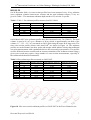
1
11th International Conference on Urban Drainage, Edinburgh, Scotland, UK, 2008
A new technique to measure cross-section
and longitudinal sediment profiles in sewers
J.-L. Bertrand-Krajewski 1*, C. Gibello 2
1
2
LGCIE, INSA-Lyon, 34 avenue des Arts, 69621 Villeurbanne cedex, France
Direction de l’Eau du Grand Lyon, 20 rue du Lac, BP 3103, 69399 Lyon cedex 03, France
* Corresponding author, email [email protected]
ABSTRACT
The measurement of sediment depth and profiles in sewers is still a difficult task. Various
attempts have been made since the 1990s to develop and apply automatic sediment
measurement techniques, but very few have been really implemented as routine techniques. A
new technique is presented in this paper, aiming to measure both cross-section and
longitudinal sediment profiles in sewers at large scale in both space and time. A marine sonar
coupled to a laser meter, installed on a floating frame, have been tested in a large man entry
sewer. The measurements are non intrusive and do not disturb or modify the sediment bed.
Each cross-section sediment profile is measured in 2 seconds, with a good accuracy
(approximately ± 1 cm). The on-line immediate display of the profiles on a laptop in the
sewer is very helpful for the operator to check the data acquisition and to repeat the
measurement in case any problem or failure is detected. For data processing, Excel® and
AutoCAD® macros have been developed to automatically correct the raw data files, to
calculate sediment areas and volumes and to draw 2D and simplified 3D views of the
sediment profiles. Examples of results for two experiments are given.
KEYWORDS
Measurements, monitoring, sewer sediments, sewer systems, sonar.
INTRODUCTION
The measurement of sediments deposited in sewers has always been a difficult task. For
operational purposes, rough estimations are made by sewermen, usually based on simple
evaluation of sediment depth in manholes by means of a graduated stick. For scientific
research programmes, measurements are also usually carried out manually with graduated
sticks, but with smaller space and time steps (see e.g. Laplace, 1991; Verbanck, 1992;
Bertrand-Krajewski et al., 2006). Manual measurements have many drawbacks, especially
i) the necessity of several persons for each measurement campaign (safety, access); ii) hard
and time consuming measurements, which cannot be made in several sites and along many
kilometres of sewers; iii) lack of cross-section sediments profiles (except in some very
specific cases); iv) impossibility to measure when high water levels and/or flow velocities
occur; v) possible disturbance of the sediment profile due to walking.
Various attempts have been made since the 1990s to develop and apply automatic sediment
measurement techniques and methods, but very few have been really implemented as routine
techniques. Inspired by previous measurements with an ultrasonic probe to measure the filling
of a sand trap in Seine-Saint-Denis (Chopard and Paitry, 1985), positive preliminary test were
Bertrand-Krajewski and Gibello
1
11th International Conference on Urban Drainage, Edinburgh, Scotland, UK, 2008
carried out to measure longitudinal sediment profiles in an experimental channel at the
Institute of Fluid Mechanics in Toulouse, France (Dartus and Bachoc, 1988). However,
despite its interest, the measurement system was not easily usable in sewers due to technical
constraints (Laplace, 1991). A fixed version to measure the evolution of local sediment levels
at one point was developed in an experimental channel and later used in the trunk sewer n° 13
in Marseille (Laplace et al., 1988; Laplace, 1991). The measurement system included i) an
ultrasonic probe attached under a fixed floating boat and ii) a second ultrasonic probe
measuring the water level in order to know the vertical position of the floating boat. Figure 1
shows the measurement system and an example of results.
Figure 1. Continuous measurements of water and sediment levels at a fixed position in a
sewer (from Laplace, 1991).
Lorenzen et al. (1992) initially developed the Göttingen Boat prototype in order to measure
the efficiency of the Göttingen Balls used for preventive sewer cleansing. The catamaran-type
boat measured longitudinal sediment profiles by floating downstream with the sewage flow.
The sediment level was derived from measurements of the angles of two arms, the first one
pressed on the sediment layer, the second one pressed on the sewer ceiling, and from
additional initial measurements in the absence of sediments. Geometrical relations allowed
calculating the sediment level and the position of the boat along the sewer. Figure 2 shows the
measurement system and an example of results. Uncertainty of measurements was evaluated
to be approximately ± 1 cm and reproducibility was excellent. However, as pointed by the
authors, “the sediment height is measured in the middle of the pipe only” and “the lower arm
is pressed more or less deeply into the sediment” depending on its characteristics.
Figure 2. Left: principle of the angle measurements. Right top: photo of the Göttingen boat,
right down: example of longitudinal water and sediment profiles (from Lorenzen et al., 1992).
2
A new technique to measure sediment profiles in sewers
11th International Conference on Urban Drainage, Edinburgh, Scotland, UK, 2008
More than fifteen years after the two above examples, very few developments have been
reported and, according to our knowledge, sewer sediment measurement has not progressed
significantly (see Ashley et al., 2004; Morel, 2005), despite innovative techniques applied in
very specific circumstances for local investigations along short distances (e.g. use of
endoscope by Oms, 2003 or cameras by Ahyerre, 1999).
Consequently, in order to be able to measure both cross-section and longitudinal sediment
profiles in sewers at large scale in both space and time, under normal flow conditions and in a
non-intrusive way, a better data acquisition technique was looked for. A market review was
carried out in 2005 and a marine sonar was identified as potentially usable for the above
purpose (Morel, 2005). A preliminary test was carried out in July 2005 in a large man-entry
sewer in Lyon with a first prototype. The results were positive and confirmed the interest of
further tests with a modified sensor. In 2006-2007, a specifically designed second prototype
was tested (Fromont and Legendre, 2007). The paper presents the sensors and the equipment
of the second prototype, the specific data processing method which has been developed, the
experimental site, two series of results and some conclusions and perspectives.
SENSORS AND EQUIPMENT
The main sensor is a 165 mm × 65 mm modified 1.1 MHz Multi-Return altimeter sonar,
model 11001 manufactured by Marine Electronics Ltd (Figure 3, left). Its rotating head scans
a 180° sector, with a range of measurable depth from 0.2 to 10 m. Echoes are measured with a
0.9° angle step, i.e. 200 measurements for each 180° sector. The beamwidth of 1.6°
corresponds to a theoretical distance resolution of 1 mm. The sonar is attached horizontally
under a 1 m × 0.5 m PVC floating frame prototype (Figure 3, right) to explore the underlying
sewer section and sediment bed. The sonar also includes additional sensors to measure both
rolling and pitching: this information is necessary to later correct the movements of the
floating frame generated by both the sewage flow and the operator. The software Profiler
4640 is used to set all measurement parameters of the sonar. The velocity of ultrasounds is
corrected according to water temperature and salinity by in situ calibration.
A LMC-J-0040-1/2 laser meter (Figure 3, left), attached vertically to the floating frame,
measures the distance hc between the frame and the sewer ceiling: this distance is used to
determine both the water level h and the position of the sonar in the sewer section. Its
measurement uncertainty is ± 2 mm in the range 0.2 - 30 m. The measured value resolution is
1 mm. The floating frame is also equipped with a battery and a WiFi transmitter installed in
an IP67 container.
laser meter
battery and
WiFi transmitter
sonar
floating frame
Figure 3. Left top: Sonar 11001 Multi Return. Left down: laser meter LMC-J-0040-1/2.
Right: floating frame.
Bertrand-Krajewski and Gibello
3
11th International Conference on Urban Drainage, Edinburgh, Scotland, UK, 2008
laptop
hc
laser
meter
Y
floating
frame
sonar
pole
Y
180°
X
Z
h
Z
Figure 4. Left: manual positioning of the floating frame in the sewer. Right: scheme of the
measurement principle.
Figure 5. On-line display of cross-section 2D sediment profiles and 3D view for several
cross-sections (Profiler 4640 user manual).
MEASUREMENT METHOD
The floating frame is introduced into the sewer through a manhole. In the sewer, it is
maintained in the appropriate position, i.e. parallel to the sewer wall and along the central axis,
by an operator by means of two poles (Figure 4, left). Initial settings for pitching and rolling
corrections are made. Then, the positioning is repeated along the sewer at each section where
a cross-section sediment profile is measured. During the experiments, the distance between
measurement sections were 5 or 20 m. At each measurement section, the height hc is
measured by the laser meter and the cross-section sediment profile is measured by the 180°
rotating sonar head (Figure 4, right). The complete profile is measured in 2 seconds.
Measurement results are immediately uploaded by the WiFi transmitter in a laptop brought in
the sewer by a second operator. The software Profiler 4640 supplied with the sonar then
displays the 2D profile and also a 3D view. This display (Figure 5) allows the on-line check
of the data and the detection of any wrong measurement or of any failure: the profile can be
measured again immediately if necessary. All data are recorded in the laptop for further data
processing.
4
A new technique to measure sediment profiles in sewers
11th International Conference on Urban Drainage, Edinburgh, Scotland, UK, 2008
DATA PROCESSING
The sonar works with polar coordinates. After conversion in Cartesian coordinates, the
software Profiler 4640 delivers an exportable text file containing the x-y-z coordinates of the
sediment bed profile (Figure 6). The X, Y and Z coordinates, centred on the sonar transducer,
correspond respectively to i) the longitudinal position along the sewer, set by the operator
before measurement at each cross section, ii) the horizontal distance between the central axis
of the sewer (where Y = 0, horizontal position of the sonar) and the lateral walls of the sewer,
and iii) the depth of the sediment bed.
X (m)
0
0
-0.001
-0.001
-0.001
-0.002
-0.002
-0.003
-0.003
Y (m)
-1.442
-1.447
-1.445
-1.446
-1.443
-1.447
-1.45
-1.441
-1.437
Z (m)
-0.013
0.01
0.033
0.056
0.078
0.101
0.124
0.146
0.169
hc (m)
3.163
3.163
3.163
3.163
3.163
3.163
3.163
3.163
3.163
Time
10535410
10535410
10535410
10535410
10535410
10535410
10535410
10535410
10535410
Figure 6. Extract of a raw data x-y-z file.
An Excel® macro has been developed (Fromont and Legendre, 2007) in order to
1) remove possible obvious outliers: a few number of echoes in some cross-section
profiles appear to be due to artefacts or correspond to locations which are outside the
sewer (e.g. Figure 5, left).
2) do geometrical corrections of the raw data before further use:
- pitching correction for the X coordinates: because of the pitching angle α, the abscissa
X1 is measured instead of the exact value X0 (Figure 7, side view)
- rolling correction for the Z and Y coordinates: because of the rolling angle β, the
sediment depth Z1 is measured instead of the exact value Z0 and the lateral distance Y1
is measured instead of the exact value Y0 (Figure 7, cross section view)
- parallelism correction: because of the non parallelism angle γ, the sewer width W1 is
measured instead of the exact value W0 (Figure 7, top view)
- centring correction: if the sonar is not on the central axis of the pipe, then Y’1 is not
equal to Y”1 (Figure 7, top view).
s on ar
side view
α
X1 X0
cross section view
Y0
s
Y’1
central axis
β
Y1
Z1
Z0
W0
s ona r
Y’’1
top view
X
γ
W1 W0
Figure 7. Geometrical corrections of raw data.
After corrections, the x-y-z file contains sediment bed coordinates corresponding to a crosssection profile centred on and perpendicular to the central axis of the sewer, and parallel to
both the sewer walls and the invert.
The corrected x-y-z file is then imported into AutoCAD® where a second macro (Fromont and
Legendre, 2007) has been developed to draw and superimpose exactly the sewer cross-section
Bertrand-Krajewski and Gibello
5
11th International Conference on Urban Drainage, Edinburgh, Scotland, UK, 2008
profile (whose coordinates are imported from the sewer section data base of the Grand Lyon
Sewer Department) and the cross-section sediment profile. The difference between the sewer
cross-section area and the sediment profile area allows calculating the sediment area A (Figure
8).
sewer
cross-section
cross-section
sediment profile
sediment
area A
Figure 8. Calculation of the cross-section sediment area A with the AutoCAD® macro.
The sediment volume Vk between two cross-sections numbered k and (k+1) is evaluated by
linear interpolation
Vk =
( Ak + Ak +1 ) ( X
2
k +1 − X k )
(1)
The integration of N successive cross-section sediment profiles and areas along a sewer reach
(measured e.g. every 5, 10 or 20 m) allows calculating the total sediment volume Vtot
Vtot =
N −1
∑ Vk
(2)
k =1
A simplified 3D representation is then drawn by the AutoCAD® macro (Figure 10).
EXPERIMENTAL SITE
4.1 m
Test measurements have been carried out in the Pierre Sémard sewer in Lyon, France (Figure
9). This large trunk sewer has two lateral sidewalks, which was very convenient for the first
measurements, and was known to have deposits. A 250 m long reach with easy access has
been chosen for sediment measurements.
4.1 m
1.3 m
2.8 m
Figure 9. Cross-section of the Pierre Sémard sewer.
6
A new technique to measure sediment profiles in sewers
11th International Conference on Urban Drainage, Edinburgh, Scotland, UK, 2008
RESULTS
On 20 December 2006, six cross-section profiles have been measured every 20 m: sediment
areas, sediment volumes between two sections and the total sediment volume (73 m3) are
given in Table 1. The maximum sediment depth reaches 0.25 m in the 3rd profile.
Table 1. Table 1. Six sediment profiles measured on 20/12/2006.
Section Distance X (m) Sediment area (m²)
profil 1
0
0.555
profil 2
20
0.548
profil 3
40
0.684
profil 4
60
0.533
profil 5
100
0.719
profil 6
120
0.550
Max sediment depth (m)
0.186
0.183
0.249
0.180
0.261
0.184
Total sediment volume (m3)
Sediment volume (m3)
11.03
12.32
12.16
25.03
12.69
73.23
On 20 March 2007, nine sediment profiles have been measured every 5 m (Table 2). The total
volume is equal to 8.2 m3 over a distance of 40 m, which is approximately one third of the
volume (11 + 12.3 = 23.3 m3) measured on 20/12/2006 along the same 40 m long reach. The
nine cross-section profiles drawn with AutoCAD® are shown in Figure 10. The sediment
profiles are not horizontal, but show peaks and troughs which indicate clearly that traditional
one point measurements with a graduated stick are not necessarily representative. The profiles
are also different between sections and an accurate estimation of the sediment volume along a
given sewer reach may require a large number of cross-section measurements, especially if
the sediment bed shows discontinuities.
Table 2. Nine sediment profiles measured on 20/03/2007.
Section Distance X (m) Sediment area (m²)
profil 1
0
0.227
profil 2
5
0.241
profil 3
10
0.224
profil 4
15
0.219
profil 5
20
0.184
profil 6
25
0.170
profil 7
30
0.226
profil 8
35
0.173
profil 9
40
0.191
Max sediment depth (m)
0.045
0.045
0.055
0.060
0.035
0.040
0.070
0.000
0.030
3
Total sediment volume (m )
3
Sediment volume (m )
1.170
1.163
1.108
1.008
0.885
0.990
0.998
0.910
8.23
Figure 10. Nine cross-section sediment profiles on 20/03/2007 in the Pierre Sémard sewer.
Bertrand-Krajewski and Gibello
7
11th International Conference on Urban Drainage, Edinburgh, Scotland, UK, 2008
Figure 11. Experimental egg-shape sewer reach available at the Grand Lyon Sewer Dpt.
CONCLUSIONS AND PERSPECTIVES
The sonar and the floating frame prototype measures cross-section sediment profiles in 2
seconds, with a good accuracy (the uncertainty in sediment depth is approximately ± 1 cm) in
large man entry sewers. The on-line immediate display of the profiles on a laptop in the sewer
is very helpful for the operator to check that data acquisition is correct and to repeat the
measurement in case any problem or failure is detected. Excel® and AutoCAD® macros have
been developed to automatically correct raw data files, to calculate sediment areas and
volumes and to draw 2D and simplified 3D longitudinal views of the sediment profiles.
The tests have been made in close collaboration between the researchers and the sewer
operator. The whole equipment is rather simple to use and was rapidly adopted by the
sewermen, which is a positive point. Measuring 13 profiles every 20 m over a 250 m long
sewer reach requires only 15 minutes for a trained team of operators. There is no need to
empty the sewer to make measurements (as required with other techniques using e.g. CCTV –
Morel, 2005). The measurements are non intrusive and do not disturb or modify the sediment
bed. If the water level is not high enough (i.e. the distance between the sonar and the sediment
bed is too short to get measurements), a simple temporary dam installed downstream the
sewer reach allows doing measurement in an easy way.
However, the first experiments carried out in a 1.8 m high egg-shape sewer reach (same shape
as shown in Figure 11, which corresponds to the most frequent section of the man entry
sewers in Lyon) were not successful. Numerous parasitic echoes, very likely due to too short
distances between the sonar and the sewer walls and the sediment bed, led to unusable data
and profiles. A modification of the sonar settings (frequency, internal data processing, etc.) is
tested in order to solve this difficulty.
Further work will include:
1) an improvement of the shape of the floating frame, to make it less sensitive to the
movement of the flowing water in the sewer, and to reduce the need of manual
handling with poles (a more autonomous equipment flowing downstream with the
sewage flow will be investigated in the future).
2) further improvement of the data processing macros (more efficient algorithms,
automation of some tasks, linkage with the Grand Lyon Sewer Department data base,
etc.).
8
A new technique to measure sediment profiles in sewers
11th International Conference on Urban Drainage, Edinburgh, Scotland, UK, 2008
3) the analysis of the most appropriate distance between cross-section profiles to ensure a
given uncertainty in the sediment volumes estimated by linear interpolation, especially
in cases where the sediment bed is not continuous and where local singularities may
have an effect on the sediment bed (connections, confluence, changes of slopes, etc.).
4) a series of tests, in a open-air experimental sewer reach (Figure 11) with easy access
and controlled conditions, in order to investigate
- the repeatability and the reproducibility of the measurements
- the uncertainty in sediment profiles and consequently in sediments areas and volumes
- the effect of the nature of deposits on the profile (comparison of sandy deposits having
a clear water-sediment interface to more organic and less dense deposits which may
create a more fuzzy water-sediment interface).
On longer term, if the first positive results are confirmed, this equipment will be used
1) for research experiments on sediment accumulation, movements and flushing in
sewers, for which more sewers will be monitored more easily and frequently than with
the traditional manual method using a graduated stick. This should contribute to a
better knowledge of the phenomena under various conditions and to improve models.
2) for operational purposes like more frequent and better monitoring of zones with high
risks of sedimentation, monitoring the efficiency of sewer cleansing devices, and a
better management of the persons and the equipments of the sewer cleansing teams.
ACKNOWLEDGEMENTS
Special thanks to R. Perez and A. Roibet, Master Students at INSA-Lyon in 2008, for their
update of the data processing macros and for having re-processed existing data series for this
paper.
REFERENCES
Ahyerre M. (1999). Bilans et mécanismes de migration de la pollution organique en réseau d'assainissement
unitaire. PhD thesis: Université Paris 6 / ENPC, Paris, France, 250 p.
Ashley R.M., Bertrand-Krajewski J.-L., Hvitved-Jacobsen T., Verbanck M., (editors) (2004). Solids in Sewers.
London (UK): IWA Publishing, Scientific and Technical Report n° 14, May 2004, 360 p. ISBN
1900222914.
Bertrand-Krajewski J.-L., Bardin J.-P., Gibello C. (2006). Long term monitoring of sewer sediment
accumulation and flushing experiments in a man-entry sewer. Wat. Sci. Tech., 54(6-7), 109-117.
Chopard P., Paitry A. (1985). Mesures d’ensablement par capteurs ultrasoniques. Service Départemental de
Seine-Saint-Denis, France, rapport, 24 p. (unpublished).
Dartus D., Bachoc A. (1988). Evaluation des capacités du système CR2M pour des mesures en laboratoire.
Toulouse (France): IMFT/CERGRENE, rapport, 70 p. (unpublished).
Fromont J., Legendre L. (2007). Automatisation du mesurage des sédiments en réseau d’assainissement. Rapport
de PIRD, LGCIE INSA-Lyon, Villeurbanne, France, 81 p.
Laplace D. (1991). Dynamique du dépôt en collecteur d'assainissement. PhD thesis: Institut National
Polytechnique de Toulouse, France, 202 p.
Laplace D., Dartus D., Bachoc A. (1988). Développement d’un dispositif de mesure « en continu » de la hauteur
de dépôt en collecteur d’assainissement. Toulouse (France) : IMFT, rapport n° 398 IMFT/ESL, 23 p.
Lorenzen A., Willms M., Dinkelacker A. (1992). The Göttingen boat. Wat. Sci. Tech., 25(8), 57-62.
Morel A. (2005). Métrologie et modélisation des sédiments en réseau d’assainissement. Rapport de Master
Recherche Génie Civil, INSA-Lyon, Villeurbanne, Septembre 2005.
Oms C. (2003). Localisation, nature et dynamique de l'interface eau-sédiment en réseau d'assainissement
unitaire. PhD thesis: ENPC, Marne-la-Vallée, France, 186 p.
Verbanck M. (1992). Field investigation on sediment occurrence and behaviour in Brussels combined sewers.
Wat. Sci. Tech., 25(8), 71-82.
Bertrand-Krajewski and Gibello
9